Embed Size (px)
Citation preview

Weather briefing – Thursday 11 June 2009
NCSU – team members…
Note: Data from many of our usual forecast tools (e.g., Bufkit, SREF, high-resolution simulated radar, SPC mesoanalysis page, etc.) were not available in
this retrospective mode… would show other/additional plots

5 Ops Objectives
1
Retrieval of collocated ground and airborne dual-frequency/polarimetric radar vertical structure and radiometer brightness temperatures in stratiform and weak convection
2Profiling of in situ microphysical properties, with particular emphasis placed on the ice phase
3Verification/calibration of ground-based multi-parameter radar retrievals
4Selected detailed sampling of the melting layer profiles and microphysics
5
Sampling of pre- and post-storm land surface characteristics at all radar and radiometer frequencies for backscatter cross-section and surface emissivity studies.

Decisions/Things to Keep in Mind(as a forecaster)
• Mission has to decide where to fly and what category of objective they’re fulfilling
• The ER-2 needs 24 hours’ notice to fly• The ER-2 crew has strict rest policies
– 12 hours after missions– 14 if mission is 8 hours– No more than 3 days without a down day
• Calls need to be made about current missions with past and future missions in mind (for the above reasons)
• The Citation should stay out of >35 dBZ• ER-2 takeoff no go if:
– 25 knots maximum steady or 35 gusts regardless of dir. – 15 knot maximum crosswind – 1/4 mile minimum visibility – Lightning within 5 NM
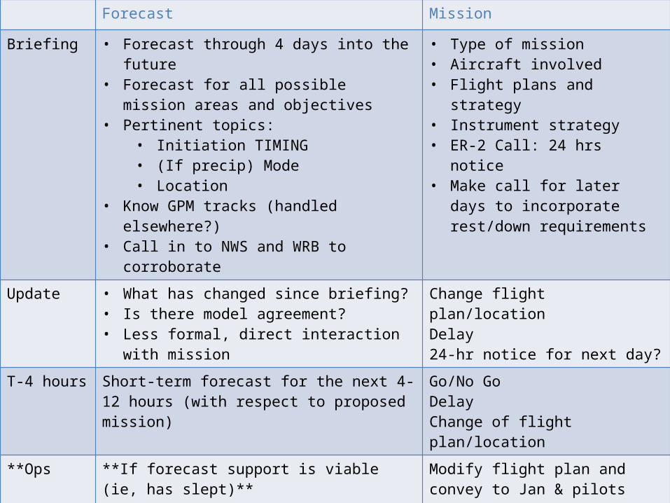
Forecast Mission
Briefing • Forecast through 4 days into the future• Forecast for all possible mission areas and
objectives• Pertinent topics:
• Initiation TIMING• (If precip) Mode• Location
• Know GPM tracks (handled elsewhere?)• Call in to NWS and WRB to corroborate
• Type of mission• Aircraft involved• Flight plans and strategy• Instrument strategy• ER-2 Call: 24 hrs notice• Make call for later days to
incorporate rest/down requirements
Update • What has changed since briefing?• Is there model agreement?• Less formal, direct interaction with mission
Change flight plan/locationDelay24-hr notice for next day?
T-4 hours Short-term forecast for the next 4-12 hours (with respect to proposed mission)
Go/No GoDelayChange of flight plan/location
**Ops **If forecast support is viable (ie, has slept)**Monitor current situation for mission and safety concerns
Modify flight plan and convey to Jan & pilots(for science reasons or something like ~35dBZ limit for Citation)
**Post-Ops **If forecast support12-24 hour range forecast for next mission (if any)
Review mission and make updated call for next mission if needed

Overview• Day -1 (W 10th): Stationary front to north, zonal flow aloft.
Humid & unstable with moderate shear. Organized convective storms in afternoon, some severe
• Day 0 (Th 11th): Instability and shear appear to have increased somewhat this morning, ingredients in place for organized convection. MCV to W this morning
• Day 1 (F 12th): Weak front drops southward during the day, possibly enhanced, organized convection over area
• Day 2 (Sa 13th) and beyond: Weak front to south of area, & weaker shear: Weaker, less organized convection. Potential for offshore convection with stalled front.

Day -1 surface analysis: 15 Z 10 June 2009

Day -1 (10 June)• MCS move east, passed to south of study area,
dissipated over GA• New convection developed ahead of MCV,
some severe (hail, wind) with these cells

Day -1 (10 June, 12-21 UTC)

NAM 500-mb Z analysis: 00 Z 11 June 2009

Nashville sounding, 00 Z 11 June 2009
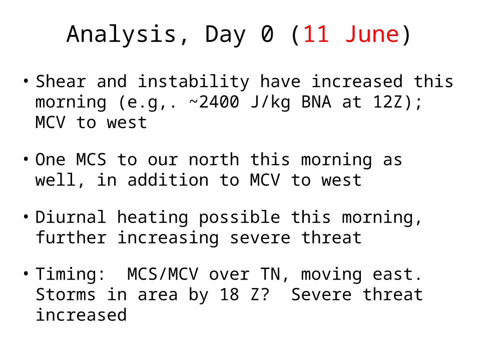
Analysis, Day 0 (11 June)
• Shear and instability have increased this morning (e.g,. ~2400 J/kg BNA at 12Z); MCV to west
• One MCS to our north this morning as well, in addition to MCV to west
• Diurnal heating possible this morning, further increasing severe threat
• Timing: MCS/MCV over TN, moving east. Storms in area by 18 Z? Severe threat increased

GOES-13 IR, 1215 Z 11 June

GOES-13 VIS, 1330 Z 11 June

NAM 500-mb Z, analysis: 12 Z 11 June 2009

HPC surface analysis: 12 Z 11 June 2009

NAM SLP, theta-e1000, 500Z valid: 12 Z 11 June

Nashville sounding, 12 Z 11 June 2009

SPC Day 1 outlook, valid 13Z 11th – 12Z 12th
Primary: Hail, wind

SE Radar Mosaic, 0-14 UTC 11 June
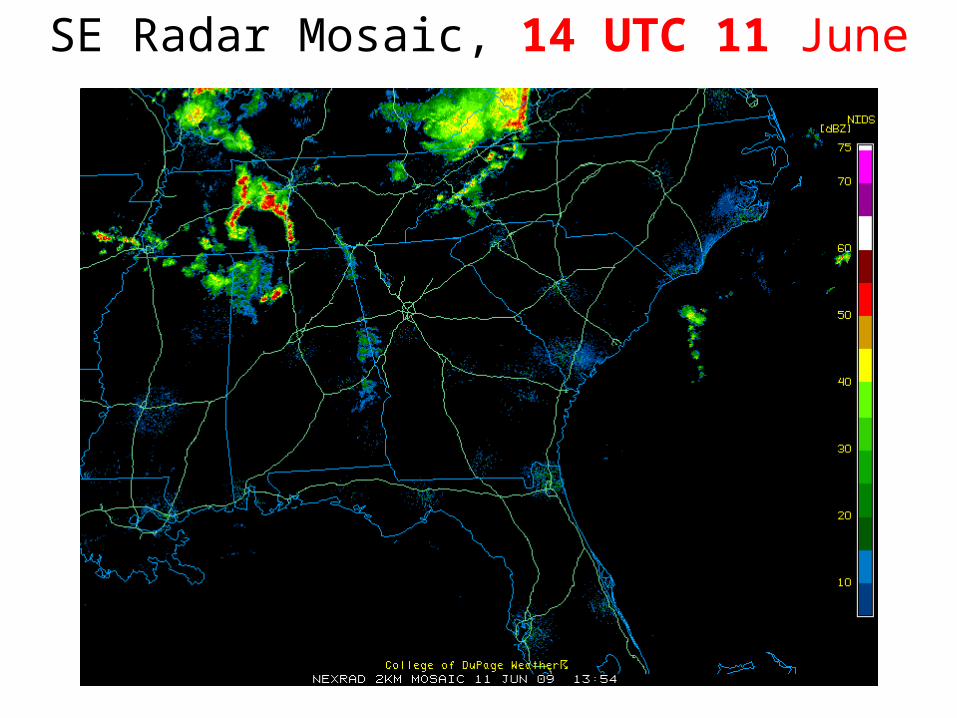
SE Radar Mosaic, 14 UTC 11 June
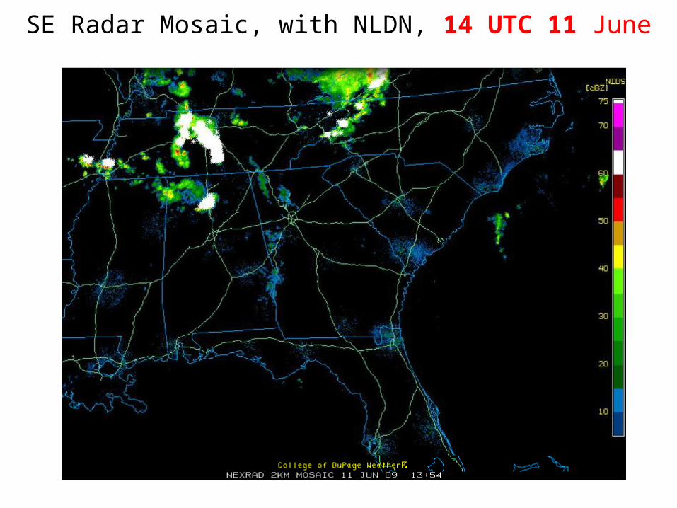
SE Radar Mosaic, with NLDN, 14 UTC 11 June

Day 0 Forecast (11 June)• Organized convection, MCV to west will approach
study area today; MCV in NAM initial condition
• New convection could fire ahead of MCV currently over western TN (similar to yesterday)
• Timing: Convective storms likely to develop between 17-20Z across study region (from west)
• Aircraft threats: Lightning, hail @Robins afternoon, Convection (winds, hail, lightning) KAVL after 17Z

NAM 12-h CAPE, CIN valid 12 Z 11 June
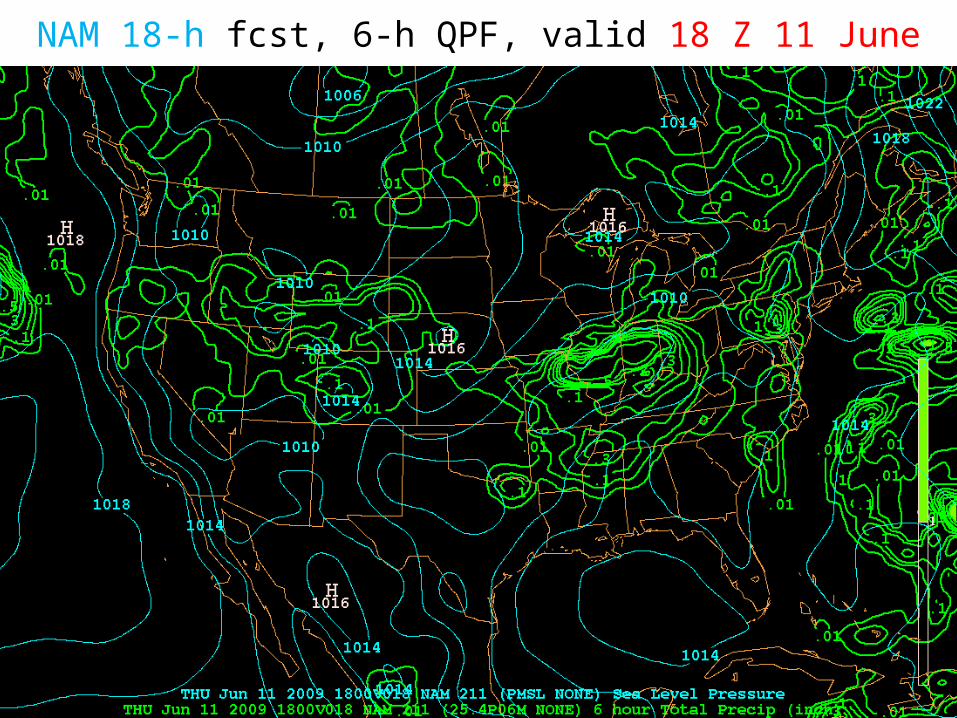
NAM 18-h fcst, 6-h QPF, valid 18 Z 11 June

NAM 18-h fcst sounding, valid 18 Z 11 JuneKAVL
WBZ: ~9200 ft
Freezing level ~11,000
Sfc-6 km shear ~ 30 kt

Day 1 Forecast (Fri 12 June)• Weak cold front approaches, opportunity for organized
convection ahead of front
• Timing of weak front difficult to establish; merges with lee trough late in day (by 00Z Sat)
• Now appears that passage will be around mid-day
• Only weak drying, stabilization behind front, more so in wake of any organized convection that forms
• As front stalls along coast, offshore convection potential increases early morning Sat and Sun (Day 2,3)

F36 NAM SLP, theta-e, 12Z 12 June

F48 NAM SLP, theta-e, 00Z 13 June

Days 2-3 (Sat, Sun)• Following weak cold front passage day 1, focus for convection
shifts southward, and to offshore waters
• Shear, instability will weaken, but sufficient instability to support diurnal orographic showers
• Frontal boundary advances northward again towards study area, potential for more showers Days 2, 3 (Sat, Sun)
• GFS shows MCV-type feature bringing strong storms to area Sun, but skeptical given convective origin of forcing in model forecast

60-h NAM SLP, theta-e, 500 Z 12 Z 13 June

Days 4+
• NW flow storms possible, shortwave passes north of area Saturday (model variability)
• With ridge axis to west (aloft), NW flow regime becomes established
• Longer term: Ensemble indicates very strong ridge developing over central US, study area in NW flow but dry with synoptic subsidence

60-h GFS 500-mb Z, SLP valid 12Z Sat 13 June

84-h GFS 500-mb Z, SLP valid 12Z Sun 14 June
Spurious system?

120-h GFS 500 Z, SLP valid 00Z Tue 16 June