Embed Size (px)
Citation preview

http://digimapforcolleges.edina.ac.uk
This is one of a series of teaching resources for use with Digimap for Colleges. For more details about this service, visit http://digimapforcolleges.edina.ac.uk
Wish you were here?Alan Parkinson
BTec Travel and Tourism teaching resource
College
© Crown Copyright and Database Right 2014. Ordnance Survey (Digimap Licence)

http://digimapforcolleges.edina.ac.uk
Introduction
The BTec Level1/Level 2 First Diploma in Travel and Tourism, and the BTec Level 1 Diploma in Introduction to the Travel and Tourism Industry both involve students in a great deal of research to develop their general understanding of the industry, and in particular the tourist attractions of the UK.
These materials are specifically designed to support the teaching of BTec First Travel and Tourism, and in particular Unit 2: UK Travel and Tourism Destinations
The focus of this unit being on the UK offers plenty of scope for using Digimap for Colleges to map the outcomes, and also make use of digital mapping, and the tools as part of the classwork and coursework that is produced by students. Maps can also be used to reinforce the importance of location when studying these places, which is a strong element of the specification here.
Ideas are provided for the first 6 lessons of the draft scheme of work provided to accompany the specification. This will provide some inspiration for using Digimap for Colleges, which can be adapted for the remaining lessons, and also for some of the other relevant units. There is a wealth of Geography and opportunities evident within the specification and the suggested activities.
The table below identifies some of the opportunities for using Digimap for Colleges to teach particular sections of the specification. The focus is on the first part of the module.
Lesson
Unit ContentUK Tourism categories
Possible activities involving Digimap
Notes
1 Capital Cities Call out UK destinations that have been visited and categorise them.Revise the location of the capital cities of the UK countries.
Include a short introduction to Digimap for Colleges as part of the course.
2 Seaside Resorts Discuss seaside resorts that have been visited by students – build up a map to show these.Explore the characteristics of resorts and produce a ‘blueprint’ for the perfect seaside resort.Discover current and historic piers if historic maps are available.
Investigate resorts on each of the coasts of the UKResearch Seaside Awards and criteria for their selection. Create a map of beaches which could be involved, and reasons for their inclusion.
3 Countryside areas such as National Parks and AONBs
Identify the National Parks and how they are shown on an OS map.Research one National Park and AONB, and produce a poster highlighting their key features and what they offer visitors, including maps.Learn locations of National Parks.
Could also explore the potential for London as a National Park.Consider the images that are used for the NP logos and why were they were chosen.Use Flickr slideshow.
4 Cultural and/or historic Explore what ‘culture’ means in Explore key cultural locations on

http://digimapforcolleges.edina.ac.ukdestinations this context.
Discuss the importance of destinations to overseas visitors, and why they are of interest. Plan a coach tour and itinerary.
the usual ‘circuit’ for overseas visitors.Could ask for maps of at least three scales for this activity.
5 UK gateway airports and UK seaports
Define the term ‘gateway’ and discuss airport ID codes. Mapping airports and seaports.
FlightRadar 24 can be used to view flights in real time and assess how busy particular airports are.This visualisation: http://contrailz.com/11_9_b0bt_-z3 provides a visual image for London airports.
6 Road and air travel Identify road and railway networks on maps – symbols that are used.Identify hubs.Create railway maps for main hubs.Creating a cultural tour using the train as method of transport.
Could explore the disused railways of the UK and how they are now used – sometimes for tourist purposes.Pinterest images of historic railway posters compared to current marketing for tourist purposes.
Preparation for teaching these lessons
Introduce students to the use of Digimap for Colleges, and download the User Guide from the resources section of the website if appropriate.
Assemble supporting resources for the teaching of this series of lessons, which could include access to images, hard copies of booklets and leaflets from a Tourist Information Centre, brochures, guide books and internet access. Students and teachers could also be asked in advance to source postcards and other supporting materials.
Digimap for Colleges Activities
Ideas are provided for the first 6 lessons of the draft scheme of work provided to accompany the specification. This will provide some inspiration for using Digimap for Colleges, which can be adapted for the remaining lessons, and also for some of the other relevant units.
Lesson 1
Students are expected to know about UK travel and tourism destinations and gateways. Identify capital cities of UK countries e.g. London, Edinburgh, Belfast, Cardiff
As students call out places they have visited within the UK, a list should be collated by the teacher, and these can be categorised into different groups, perhaps at the same time. Discussions on the types of attraction that are being listed may happen before this takes place e.g. historic, scenic or coastal. Use Digimap to ‘visit’ one or more of the capital cities in the UK, and compare them in terms of their tourist attractions.

http://digimapforcolleges.edina.ac.ukGroups should then be asked to create a categorised map for a particular type of attraction, using Digimap for Colleges, which can then be generated as a PDF map, and given an appropriate title. These can used to prompt discussions on the distribution of particular types of attractions, and whether there are patterns to this.
A display board of appropriate maps could also be produced for the classroom wall as the unit progresses. The ongoing reinforcement of location will be particularly helpful for this unit, and this is a strength of using Digimap for Colleges regularly.
Students are expected to know about attractions local to their particular location.
Discussion questions:
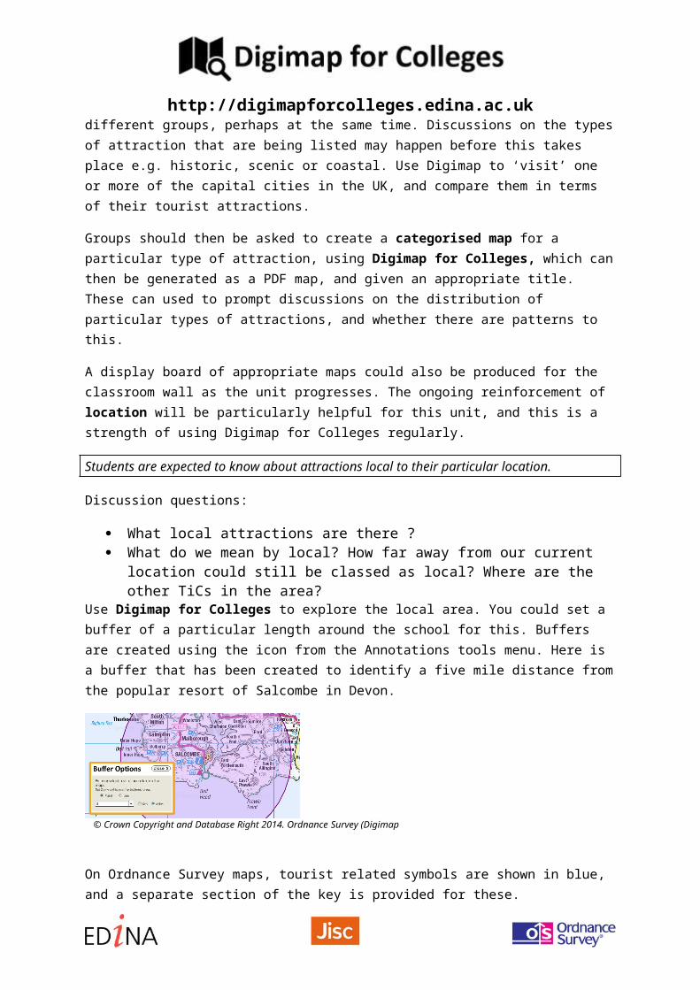
What local attractions are there ? What do we mean by local? How far away from our current location could still be
classed as local? Where are the other TiCs in the area?Use Digimap for Colleges to explore the local area. You could set a buffer of a particular length around the school for this. Buffers are created using the icon from the Annotations tools menu. Here is a buffer that has been created to identify a five mile distance from the popular resort of Salcombe in Devon.
On Ordnance Survey maps, tourist related symbols are shown in blue, and a separate section of the key is provided for these.
Students could use this key to produce an index of how ‘touristy’ the local area is compared to other nearby towns and villages.
© Crown Copyright and Database Right 2014. Ordnance Survey (Digimap Licence)
http://digimapforcolleges.edina.ac.ukHow is the local area described in the main tourist guides to the UK such as Lonely Planet and Rough Guide?
Lesson 2
Students are expected to know about seaside resorts on the E, S and W coasts e.g. Weston-super-Mare, Brighton, Scarborough
Seaside resorts are the focus for the start of this lesson. Teachers could identify a number of seaside resorts and create maps first. Students could then be asked to look for similarities between the resorts that are suggested.
Use the Seaside Resorts presentation (PPT) to support this method of introducing the resorts.
Identify a number of other coastal resorts that students have visited within the UK, and ask similar questions.
Use a series of maps of explore the nature of these resorts and add labels to show comments on what people thought of some of the resorts that are being explored.
Seaside Awards are also mentioned in the specification
Students could be allocated a resort which has the Seaside Award, and use Digimap for Colleges and annotation tools to identify evidence for particular tourist facilities which are expected of a resort that has this particular accreditation.
The list of 2014 holders of the Seaside Award and Blue Flags are shown here: http://www.keepbritaintidy.org/blueflagseasideawards2014/1362
One additional ‘fun’ activity could be to use the annotation tools to add any obvious clues as to the identity of a seaside location to a map that is lacking its name, and ask students to identify them. Blackpool has some fairly obvious features which won’t necessarily be obvious on the map.
Extension activity 1: Recipe for a Resort
Imagine putting together a ‘recipe’ for a seaside resort ?
What would the ingredients be, and how would they need to be combined to create the resort. How would you ‘serve up’ the results of your recipe? Set this as a creative / literacy task.
e.g. Take one pier, and stretch it out over the sea.
Serve with lashings of rain on Bank Holiday Monday…
Use the Recipe for a Seaside Resort sheet (PDF) to plan your ideas
Extension activity 2: Peering at piers

http://digimapforcolleges.edina.ac.ukPiers used to be much more common than they are now. Many resorts had a pier as a promenade, and to host additional entertainment, such as theatres and amusement arcades. Some have succumbed to flames, most recently Eastbourne pier in August 2014.
Use Digimap for Colleges to identify those resorts that have piers, and print them off at the same map scale to compare them. Which piers are the longest in the UK?
Here is a list of some resorts with piers: http://www.piers.org.uk/pierpages/NPS0regionssurv.html
See the Mystery Pier activity at the end of the document
Extension activity 3: “Answers on a postcard”
Using old seaside postcards or railway posters from UK resorts (these can easily be found online at sites like Pinterest) try to match the locations to the map, and perhaps identify the locations where the images in the postcard may have been taken. Here is an example image from Pinterest of Brighton pier, for example:
http://media-cache-ak0.pinimg.com/originals/2d/22/23/2d22232a86401741a65fb6ba74cb9ab6.jpg
Small images of the postcards can be added to Digimap using the Annotations toolbar. It’s a good idea to resize the images before adding them.
Details of how to add photos are provided in the Digimap user guide, but are summarised below:
Adding a photograph to Digimap for Colleges
Open the annotation tool bar and select the ‘add an image’ tool.
Click on the map where you want the picture to appear, a dialogue box will open:
http://digimapforcolleges.edina.ac.uk
Browse to the selected file. Use the Move Feature option to position the image correctly if it obscures some important detail. Select the four headed arrow and click on the photograph. You will be able to move it around on the map. To relocate the pin, click on the pin and both the photograph and the pin will move. De-select the arrow when you are happy with the new location.
Lesson 3
Students are expected to know the names of the National Parks of England and Wales, and National Scenic areas in Scotland, along with researching at least one AONB
There are 15 National Parks in England and Wales, and 40 National Scenic Areas in Scotland. Learning these will take some repetition and study, which Digimap for Colleges can assist with.
Identify the locations of the main National Parks on a larger map of the UK. How are these areas marked on OS maps?
The boundary of the parks is always shown, although the symbol varies.
On 1: 50 000 maps, it is a yellow continuous stripe.
The edge of the Peak District near Sheffield is shown to the right, for example:
On 1: 25 000 maps, it is a dis-continuous pink stripe.
Consider the definition of a National Park as shown below. The Environment Act 1995 revised the original legislation and set out two statutory purposes for National Parks in England and Wales:
1. Conserve and enhance the natural beauty, wildlife and cultural heritage
2. Promote opportunities for the understanding and enjoyment of the special qualities of National Parks by the Public
When National Parks carry out these purposes they also have the duty to:
3. Seek to foster the economic and social well being of local communities within the National Parks
Look for the following symbols, which connect with the idea of natural beauty, wildlife and cultural heritage:
© Crown Copyright and Database Right 2014. Ordnance Survey (Digimap Licence)

http://digimapforcolleges.edina.ac.uk
AONBs are more numerous, and are designated for similar reasons:
An Area of Outstanding Natural Beauty (AONB) is an area outside a National Park that is considered by Natural England to be of such outstanding natural beauty that it should be designated for the purpose of conserving and enhancing natural beauty.
Natural England is responsible for the designation of AONBs. Local authorities can propose an area for consideration by Natural England as a potential AONB but it is Natural England who decide whether to take it forward.
Students could explore their local area and put together a bid for it to become an AONB, and use the annotation tools to identify supporting evidence.
The production of a poster could be one outcome from this lesson. Students could create a series of map details to add to the poster. The poster should incorporate these maps, or be a map itself. Students could be introduced to websites such as Big Huge Labs, or apps such as Over and Phoster.
Rights of Way
There are new rules for access to land in National Parks, and these could be explored with students.
Extension Activity: Honeypots
National Parks usually have particular villages, which attract lots of visitors, because of the presence of a landscape or buildings of historical or cultural interest.
Use the mapping to explore honeypots and identify some common characteristics that they might have:
e.g. Castleton in the Peak District, Lyndhurst in the New Forest, Wroxham in the Norfolk Broads
Lesson 4

http://digimapforcolleges.edina.ac.ukStudents are expected to know a range of cultural and historical locations in the UK, and be able to plan a coach tour for USA holiday-makers that connects them together
Cultural and historic destinations offer a range of attractions to visitors, particularly those from overseas. The itinerary for Japanese, American or, increasingly Chinese visitors is a bit of a whistle-stop tour, and can include some or all of the following places:
London – iconic places in the city
Stratford upon Avon – Shakespeare
Stonehenge
Edinburgh – castle, tattoo, fringe, whisky
Cambridge – university
York – historic buildings, Minster
Liverpool – The Beatles, Ferry across the Mersey
Dublin – irish genealogy
Students should be asked to imagine a group of American visitors, who are on a coach tour. Identify and plan a route which they could take, using appropriate scales of mapping on Digimap. Remember that there is road-atlas scale mapping available as well as the larger map scales.
The next UK City of Culture will be Hull, in 2017: http://www.bbc.co.uk/news/entertainment-arts-25008856 - the previous one was Londonderry.
Why not explore Hull: a city that is not often mentioned, and identify the cultural potential.
Lesson 5
Students are expected to define the term ‘gateway’ airport and be familiar with the important UK airports and seaports. ID codes for airports should be known.
Gateway airports are those which are used as the main entry points for international flights. You could use: www.world-airport-codes.com to identify these, or take them from a Top 20 list by passengers.
Which airports have student used in the past? Can they remember the codes on their luggage tags? Airport runways are quite easy to spot from the air on mapping – can students explain the direction that the runways are facing?
The buffer tool could be used to explore the potential impact of noise generated by an airport. The buffer tool will work along a line.

http://digimapforcolleges.edina.ac.ukThe Contrailz tool: http://contrailz.com/11_9_b0bt_-z3 shows the routes taken from major London airports, so students could identify areas affected.
A final gateway that might be worth mentioning is the Channel Tunnel. You could ask students to locate the entrance to the tunnel and measure how far the train runs underground before it reaches the English Channel, using the measuring tool.
Lesson 6
Students are expected to recognise main road and railway hubs, and the network that they serve, and identify main railway stations.
Roads and railways are marked on all OS maps. The keys for 1: 25 000 and 1: 50 000 maps can be obtained when viewing them. At lower zoom levels, ‘road atlas’ style mapping is provided in Digimap for Colleges, which will be helpful for the activities in this lesson.
Access the relevant keys for maps to show how roads and railways are shown. Explore the location of the main railway stations in towns and cities. Are they often located in similar areas?
e.g. 1: 50 000
Many railways in the UK were lost during the ‘Beeching’ cuts in the 1960s http://en.wikipedia.org/wiki/Beeching_cuts
Some of these are now used for other purposes. Large scale mapping could be used to try to retrace the route of a ‘lost’ railway line, and perhaps produce a plan to resurrect the line. There has been a long running campaign to reinstate many local lines – there may be one near you.
Railway journeys have not always taken place in the same way and from the same stations as now. Some of the current railway hubs are larger than they used to be. Use historical mapping to explore the changing fortunes of stations like Crewe.
One interesting activity would be to look at the location of the major railway stations in London and look at their location relative to the actual centre of the city, and the current ‘edge’ of the city.
The marketing of railways is another interesting area that could be explored. Pinterest could once again be used to source vintage railway posters, such as the classic ‘Metroland’ posters, or those of the London Underground. Link this to the suggested activity of planning a cultural and historical tour using the railway as a form of transport.

http://digimapforcolleges.edina.ac.ukReferences
It is worth accessing a range of tourist-related books as background reading for students, such as Rough and Lonely Planet Guides to the UK.
Piers
Current: http://www.piers.org.uk/pierpages/NPS0regionssurv.html and lost (can you find them with the Historic slider?): http://www.piers.org.uk/pierpages/NPS0regionslost.html
National Parks
The Greater London National Park* is an idea which has been developed recently by Daniel Raven-Ellison: http://www.greaterlondonnationalpark.org.uk/
Scottish National Scenic Areas (NSAs): http://www.snh.gov.uk/protecting-scotlands-nature/protected-areas/national-designations/nsa/
A Pinterest board of images for this resource has been created, and will be added to periodically:
http://www.pinterest.com/geoblogs/digimap-btec-travel-and-tourism/
Sign up to Pinterest to create your own ‘mood boards’.
Airports
Guardian datablog with details on the world’s largest airports
http://www.theguardian.com/news/datablog/2012/may/04/world-top-100-airports

http://digimapforcolleges.edina.ac.ukAppendix: Mystery Pier Activity
Source: http://www.ordnancesurvey.co.uk/blog/2013/11/enter-our-piers-quiz/

http://digimapforcolleges.edina.ac.uk
Answers1. Clacton-on-Sea2. Brighton3. Llandudno4. Ryde5. Cromer6. Blackpool (North Pier)7. Bangor8. Mumbles
Shared on the Ordnance Survey Blog: http://www.ordnancesurvey.co.uk/blog/2013/11/enter-our-piers-quiz/
©EDINA at the University of Edinburgh 2014
This work is licensed under a Create Commons Attribution-Non Commercial Licence