Embed Size (px)
Citation preview
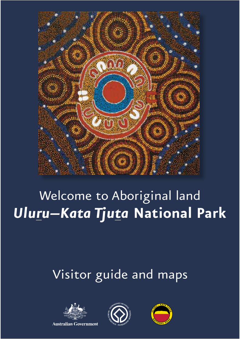
Welcome to Aboriginal land
Visitor guide and maps
Uluru–Kata Tjuta National Park
Kata Tjutadune viewing area
(sunrise and sunset)
to Kaltukatjaraand WA border(permit required)
Lasseter Highwayto Alice Springs 443 kmErlunda 241 km
sunset viewing areas
sunset viewingareas
sunrise viewing area
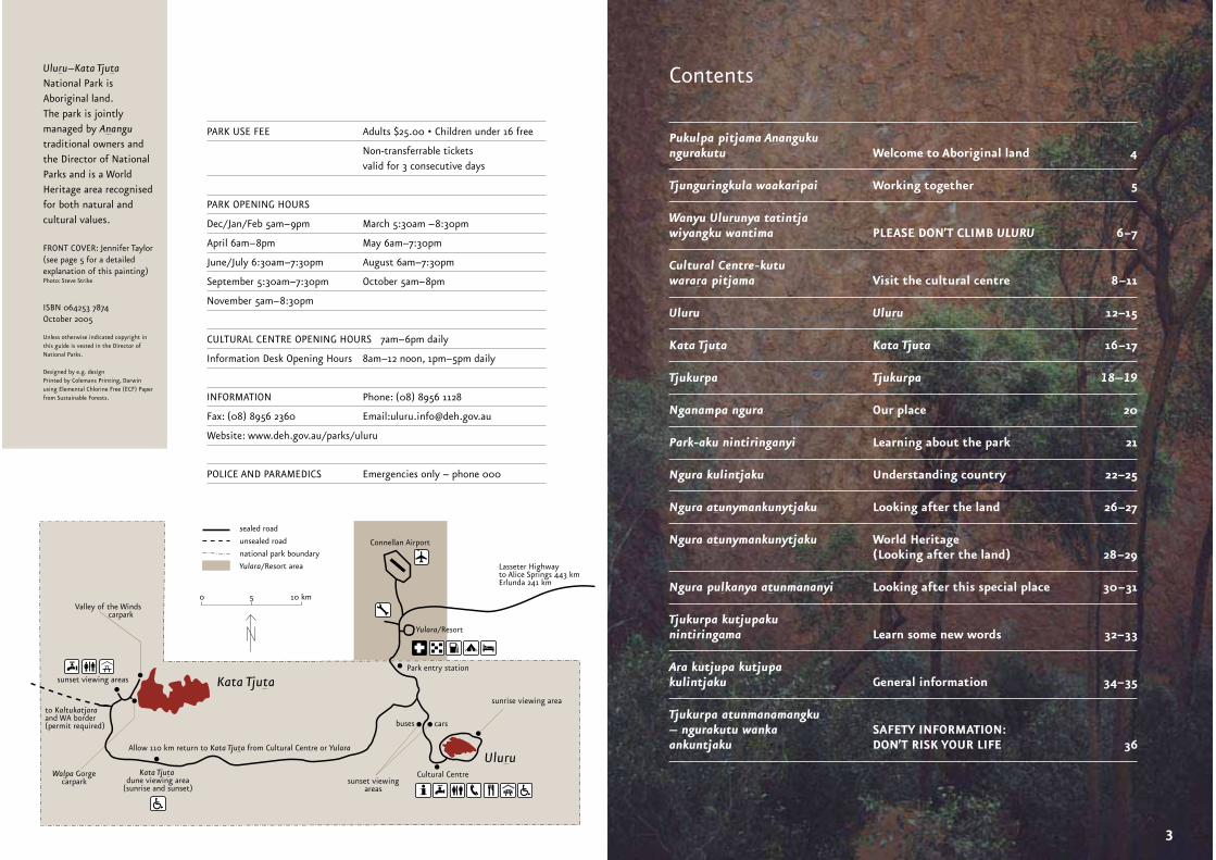
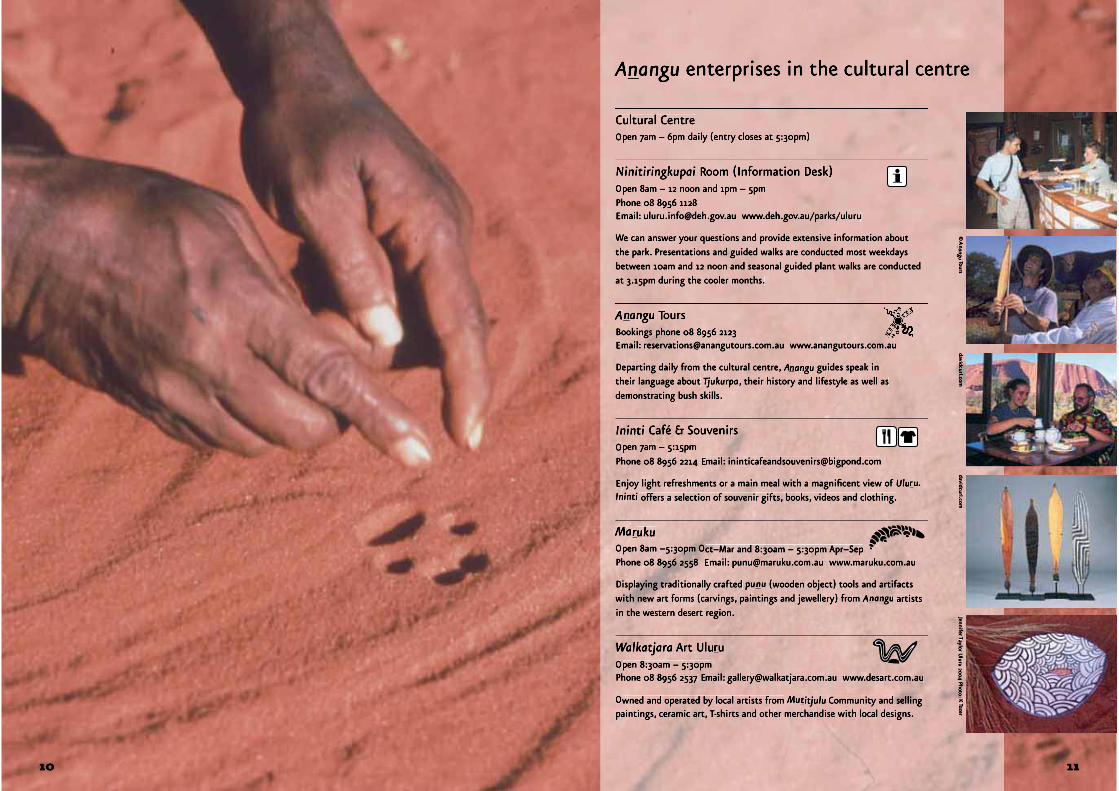
Cultural Centre
carsbuses
Valley of the Winds carpark
Park entry station
Connellan Airport
Yulara/Resort
sealed road
unsealed road
national park boundary
Yulara/Resort area
Allow 110 km return to Kata Tjuta from Cultural Centre or Yulara
0 5 10 km
Kata Tjuta
UluruWalpa Gorge
carpark
FRONT COVER: Jennifer Taylor(see page 5 for a detailed explanation of this painting) Photo: Steve Strike
ContentsUluru–Kata TjutaNational Park is Aboriginal land. The park is jointly managed by Anangutraditional owners and the Director of NationalParks and is a World Heritage area recognised for both natural and cultural values.
ISBN 064253 7874October 2005
Unless otherwise indicated copyright in this guide is vested in the Director of National Parks.
Designed by e.g. designPrinted by Colemans Printing, Darwin using Elemental Chlorine Free (ECF) Paper from Sustainable Forests.
Pukulpa pitjama Anangukungurakutu Welcome to Aboriginal land 4
Tjunguringkula waakaripai Working together 5
Wanyu Ulurunya tatintja wiyangku wantima PLEASE DON’T CLIMB ULURU 6–7
Cultural Centre-kutu warara pitjama Visit the cultural centre 8–11
Uluru Uluru 12–15
Kata Tjuta Kata Tjuta 16–17
Tjukurpa Tjukurpa 18–19
Nganampa ngura Our place 20
Park-aku nintiringanyi Learning about the park 21
Ngura kulintjaku Understanding country 22–25
Ngura atunymankunytjaku Looking after the land 26–27
Ngura atunymankunytjaku World Heritage (Looking after the land) 28–29
Ngura pulkanya atunmananyi Looking after this special place 30–31
Tjukurpa kutjupaku nintiringama Learn some new words 32–33
Ara kutjupa kutjupa kulintjaku General information 34–35
Tjukurpa atunmanamangku– ngurakutu wanka SAFETY INFORMATION:ankuntjaku DON’T RISK YOUR LIFE 36
PARK USE FEE Adults $25.00 • Children under 16 free
Non-transferrable tickets valid for 3 consecutive days
PARK OPENING HOURS
Dec/Jan/Feb 5am–9pm March 5:30am –8:30pm
April 6am–8pm May 6am–7:30pm
June/July 6:30am–7:30pm August 6am–7:30pm
September 5:30am–7:30pm October 5am–8pm
November 5am–8:30pm
CULTURAL CENTRE OPENING HOURS 7am–6pm daily
Information Desk Opening Hours 8am–12 noon, 1pm–5pm daily
INFORMATION Phone: (08) 8956 1128
Fax: (08) 8956 2360 Email:[email protected]
Website: www.deh.gov.au/parks/uluru
POLICE AND PARAMEDICS Emergencies only – phone 000
3
Pukulpa pitjama Anangukungurakutu
p pp p
Pukul ngalya yanamaAnanguku ngurakutu.—Yankunytjatjara welcome
Pukulpa pitjama Anangukungurakutu.—Pitjantjatjara welcome
This is Aboriginal land and you are welcome. Lookaround and learn in order to understand Aboriginal people and also understand that Aboriginal culture is strong and alive.—© Nellie Patterson,Traditional Owner
Welcome to Aboriginal land
We, the traditional landowners of Uluru–Kata Tjuta National Park, are Yankunytjatjara and Pitjantjatjara people. We speak our own language and teach it to our children. In our language we call ourselves Anangu(pronounced arn-ang-oo) and we would like you to use that word too.
The land that is now Uluru–Kata Tjuta National Park was created by the Tjukuritja (creation ancestors). In their travels they left marks in the landand made laws for us to keep and live by. We hope that, during your visit, you will learn about some of our creation ancestors and some of our law and culture. Please respect this knowledge and open your minds and hearts so you can really appreciate our enduring culture.
Uluru, Kata Tjuta and the land around them have always been very specialplaces. Now this is recognised by their listing as a World Heritage area forboth their cultural and natural values. We think you will be inspired by thenatural beauty and power of our land. We hope you enjoy it and return safely to your homes and families to share the knowledge you have gained.
Together with the TT Uluru–Kata Tjuta Board of Management and the staff of Parks Australia, we welcome you to Uluru–Kata Tjuta National Park.
For tens of thousands of years Uluru and Kata Tjuta were on Aboriginal land. Piranpa (non-Aboriginal) people put us in a reserve set aside for Anangu. In the 1940s the area was excised from the reserve area to be made a national park.During the years when we were not in control, our sacred places were not looked after properly. We were not able to look after the land the way our ancestors hadtaught us.
After many years of hard work and negotiations, the title deeds to Uluru–KataTjuta were handed back to us by the Governor General of Australia in 1985.We, in turn, leased the land back to the Federal Government for 99 years. Since that time we have been managing Uluru–Kata Tjuta National Park together with Parks Australia. This process of working together has come to be known as ‘joint management’. An important part of managing the park is keeping our traditional law to guide us. We try to do this while accommodating the interestsof non-A- nangu people on our lands.
It’s not always easy. We understand that visitors and people in business want to use the park. We also have aresponsibility to protect the environment of the park and our people. We want visitors to learn about our land andour culture and have a safe and happy visit.
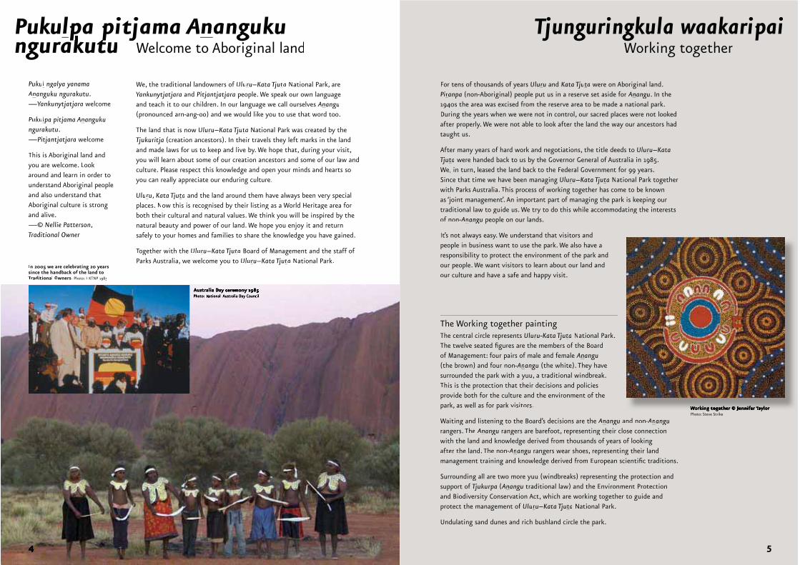
Tjunguringkula waakaripai
The Working together paintingThe central circle represents Uluru-Kata Tjuta National Park. The twelve seated figures are the members of the Board of Management: four pairs of male and female Anangu(the brown) and four non-A- nangu (the white). They havesurrounded the park with a yuu, a traditional windbreak. This is the protection that their decisions and policiesprovide both for the culture and the environment of thepark, as well as for park visitors.
Waiting and listening to the Board’s decisions are the Anangu and non-A- nangurangers. The Anangu rangers are barefoot, representing their close connection with the land and knowledge derived from thousands of years of lookingafter the land. The non-A- nangu rangers wear shoes, representing their landmanagement training and knowledge derived from European scientific traditions.
Surrounding all are two more yuu (windbreaks) representing the protection and support of Tjukurpa (Anangu traditional law) and the Environment Protectionand Biodiversity Conservation Act, which are working together to guide andprotect the management of Uluru–Kata Tjuta National Park.
Undulating sand dunes and rich bushland circle the park.
Working together
In 2005 we are celebrating 20 yearssince the handback of the land toTraditional Owners. Photo: UKTNP 1985
g g J yPhoto: Steve Strike
5
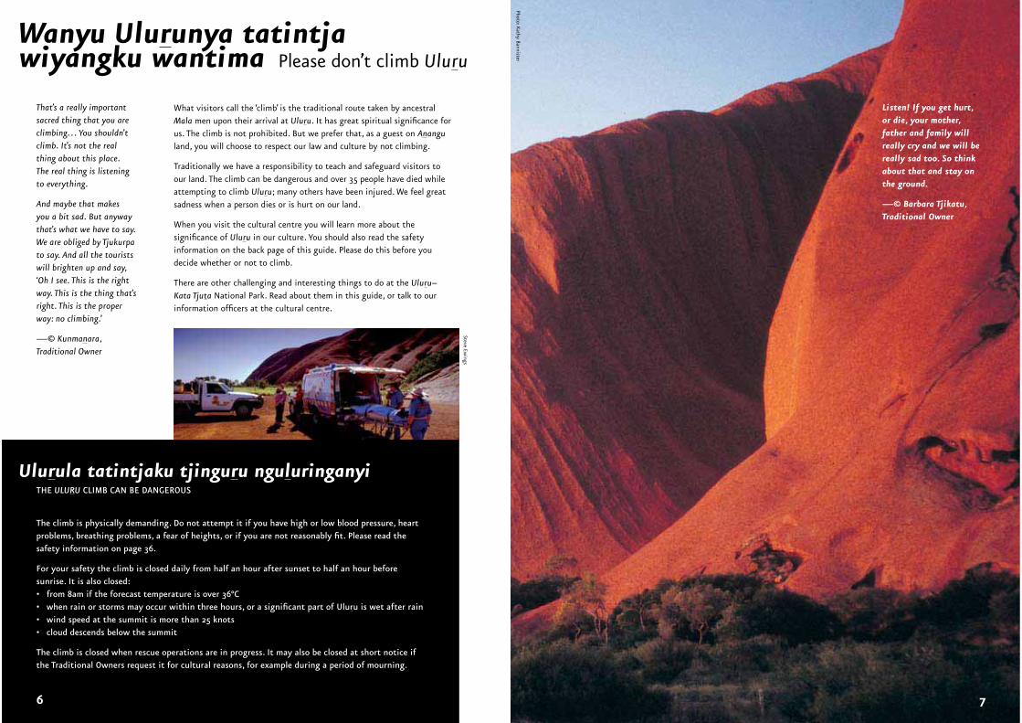
What visitors call the ‘climb’ is the traditional route taken by ancestral Mala men upon their arrival at Uluru. It has great spiritual significance for us. The climb is not prohibited. But we prefer that, as a guest on Ananguland, you will choose to respect our law and culture by not climbing.
Traditionally we have a responsibility to teach and safeguard visitors to our land. The climb can be dangerous and over 35 people have died while attempting to climb Uluru; many others have been injured. We feel great sadness when a person dies or is hurt on our land.
When you visit the cultural centre you will learn more about the significance of Uluru in our culture. You should also read the safety information on the back page of this guide. Please do this before you decide whether or not to climb.
There are other challenging and interesting things to do at the Uluru–Kata Tjuta National Park. Read about them in this guide, or talk to our information officers at the cultural centre.
That’s a really important sacred thing that you are climbing… You shouldn’t climb. It’s not the real thing about this place. The real thing is listening to everything.
And maybe that makes you a bit sad. But anyway that’s what we have to say. We are obliged by Tjukurpa to say. And all the tourists will brighten up and say, ‘Oh I see. This is the right way. This is the thing that’s right. This is the proper way: no climbing.’
—© Kunmanara,Traditional Owner
Listen! If you get hurt, or die, your mother, father and family will really cry and we will be really sad too. So thinkabout that and stay on the ground.
—© Barbara Tjikatu, Traditional Owner
SteveEw
ings
Photo: Kathy Bannister
THE ULURU CLIMB CAN BE DANGEROUS
The climb is physically demanding. Do not attempt it if you have high or low blood pressure, heart problems, breathing problems, a fear of heights, or if you are not reasonably fit. Please read the safety information on page 36.
For your safety the climb is closed daily from half an hour after sunset to half an hour before sunrise. It is also closed:• from 8am if the forecast temperature is over 36°C• when rain or storms may occur within three hours, or a significant part of Uluru is wet after rain• wind speed at the summit is more than 25 knots• cloud descends below the summit
The climb is closed when rescue operations are in progress. It may also be closed at short notice if the Traditional Owners request it for cultural reasons, for example during a period of mourning.
Ulurula tatintjaku tjinguru nguluringanyi
Wanyu Ulurunya tatintja wiyangku wantima Please don’t climb Uluru
76
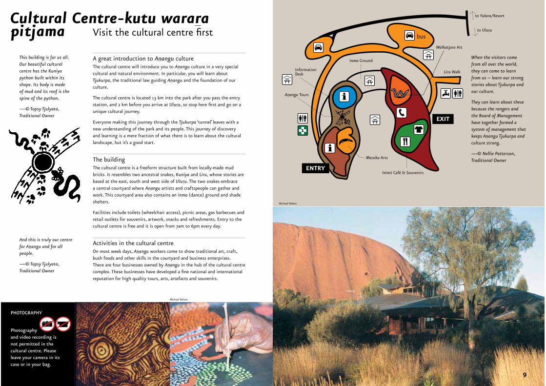
A great introduction to Anangu cultureThe cultural centre will introduce you to Anangu culture in a very special cultural and natural environment. In particular, you will learn about Tjukurpa, the traditional law guiding Anangu and the foundation of our culture.
The cultural centre is located 13 km into the park after you pass the entry station, and 2 km before you arrive at Uluru, so stop here first and go on a unique cultural journey.
Everyone making this journey through the Tjukurpa ‘tunnel’ leaves with a new understanding of the park and its people. This journey of discovery and learning is a mere fraction of what there is to learn about the cultural landscape, but it’s a good start.
The buildingThe cultural centre is a freeform structure built from locally-made mud bricks. It resembles two ancestral snakes, Kuniya and Liru, whose stories are based at the east, south and west side of Uluru. The two snakes embrace a central courtyard where Anangu artists and craftspeople can gather and work. This courtyard area also contains an inma (dance) ground and shade shelters.
Facilities include toilets (wheelchair access), picnic areas, gas barbecues and retail outlets for souvenirs, artwork, snacks and refreshments. Entry to the cultural centre is free and it is open from 7am to 6pm every day.
Activities in the cultural centreOn most week days, Anangu workers come to show traditional art, craft, bush foods and other skills in the courtyard and business enterprises. There are four businesses owned by Anangu in the hub of the cultural centre complex. These businesses have developed a fine national and international reputation for high quality tours, arts, artefacts and souvenirs.
When the visitors come from all over the world, they can come to learn from us – learn our strong stories about Tjukurpa and our culture.
They can learn about these because the rangers and the Board of Management have together formed a system of management that keeps Anangu Tjukurpa and culture strong.
—© Nellie Patterson, Traditional Owner
This building is for us all. Our beautiful cultural centre has the Kuniya python built within its shape. Its body is made of mud and its roof is the spine of the python.
—© Topsy Tjulyata, Traditional Owner
Cultural Centre-kutu wararapitjama
And this is truly our centre for Anangu and for all people.
—© Topsy Tjulyata, Traditional Owner
PHOTOGRAPHY
Photographyand video recording is not permitted in the cultural centre. Please leave your camera in its case or in your bag.
Michael Nelson
Michael Nelson
ENTRY
EXIT
InformationDesk
Inma Ground
to Yulara/Resort
to Uluru
Anangu Tours
Maruku Arts
Walkatjara Art
Liru Walk
Ininti Café & Souvenirs
bus
1
Visit the cultural centre first
8 9
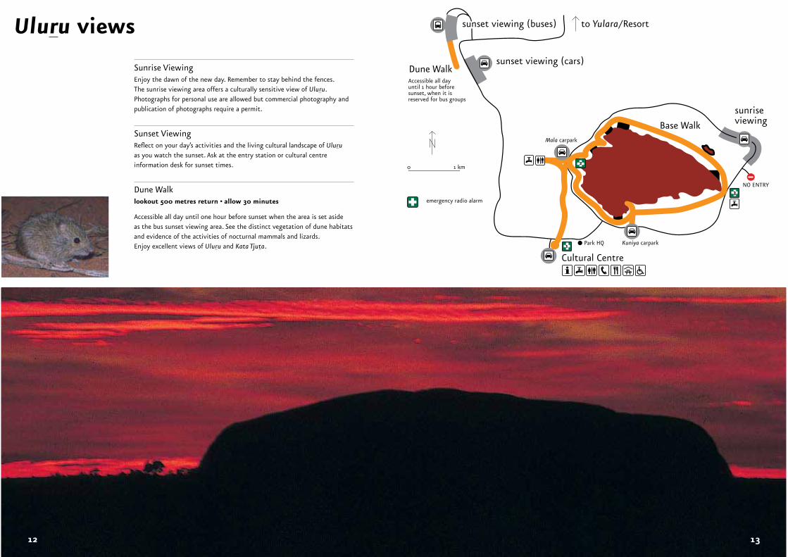
Uluru views
Sunrise ViewingEnjoy the dawn of the new day. Remember to stay behind the fences. The sunrise viewing area offers a culturally sensitive view of Uluru. Photographs for personal use are allowed but commercial photography and publication of photographs require a permit.
Sunset ViewingReflect on your day’s activities and the living cultural landscape of Uluruas you watch the sunset. Ask at the entry station or cultural centre information desk for sunset times.
Dune Walklookout 500 metres return • allow 30 minutes
Accessible all day until one hour before sunset when the area is set aside as the bus sunset viewing area. See the distinct vegetation of dune habitats and evidence of the activities of nocturnal mammals and lizards. Enjoy excellent views of Uluru and Kata Tjuta. Kuniya carparkPark HQ
Mala carpark
Base Walk
sunriseviewing
sunset viewing (cars)Dune WalkAccessible all dayuntil 1 hour before sunset, when it isreserved for bus groups
NO ENTRY
Cultural Centre1
2
3
0 1 km
emergency radio alarm
sunset viewing (buses) to Yulara/Resort
12 13
Uluru walks
Mala Puta
Pulari
Kuniya Piti
Taputji
Kuniya carpark
NOENTRY
Mutitjulu Waterhole
Park headquarters
Mala carpark
Kuniya Walk
Base Walk
LiruWalk
Cultural Centre
Mala Walk
Kantju Gorge
Tjukatjapi
WarayukiNgaltawata
2
1
3
0 1 km
sunrise viewing
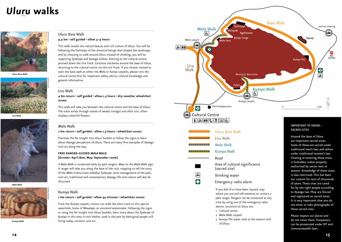
Uluru Base Walk9.4 km • self guided • allow 3–4 hours
This walk reveals the natural beauty and rich culture of Uluru. You will be following the footsteps of the ancestral beings that shaped the landscape, and by choosing to walk around Uluru instead of climbing, you will be respecting Tjukurpa and Anangu wishes. Starting at the cultural centre, proceed down the Liru Track. Continue clockwise around the base of Uluru, returning to the cultural centre via the Liru Track. If you choose instead to start the base walk at either the Mala or Kuniya carparks, please visit the cultural centre first for important safety advice, cultural knowledge and general information.
Liru Walk4 km return • self guided • allow 1.5 hours • dry–weather wheelchair access
This walk will take you between the cultural centre and the base of Uluru. The track winds through stands of wanari (mulga) and after rain, often displays colourful flowers.
Mala Walk2 km return • self guided • allow 1.5 hours • wheelchair access
Purchase the ‘An Insight into Uluru’ booklet or follow the signs to learn about Anangu perceptions of Uluru. There are many fine examples of Anangurock art along the way.
FREE RANGER–GUIDED MALA WALK[October–April 8am; May–September 10am]
A Mala Walk is conducted daily by park rangers. Meet at the Mala Walk sign. A ranger will take you along the base of the rock, stopping to tell the story of the Mala (rufous hare wallaby) Tjukurpa. Joint management of the park, rock art, traditional and contemporary Anangu life and culture will also be discussed.
Kuniya Walk1 km return • self guided • allow 45 minutes • wheelchair access
From the Kuniya carpark, visitors can walk the short track to this special waterhole, home of Wanampi, an ancestral watersnake. Following the signs or using the ‘An Insight into Uluru’ booklet, learn more about the Tjukurpa of Kuniya in this area. A rock shelter, used in the past by Aboriginal people still living today, contains rock art.
If you feel ill or have been injured, stay where you are and tell someone to contact a park ranger. Rangers can be contacted at any time by using one of the emergency radio alarms. Locations at Uluru are:1 Cultural centre 2 Mala Walk carpark3 Kuniya Piti water tank at the eastern end
of Uluru
Kuniya Walk
Mala Walk
Area of cultural significance (sacred site)
Road
Drinking water
Emergency radio alarm
Liru Walk
Uluru Base Walk
Uluru Base Walk
Liru Walk
Mala Walk
Kuniya Walk
IMPORTANT TO KNOW –SACRED SITES
Around the base of Uluruare important sacred areas. Some of these are sacred under traditional men’s law, and others under traditional women’s law. Viewing or entering these areas is forbidden unless properly authorised by senior men or women. Knowledge of these areas is also restricted. This has been our custom for tens of thousands of years. These sites are cared for by the right people according to Anangu law. They are fenced and registered as sacred areas. It is very important that you do not enter or take photographs of these sacred sites.
Please respect our places and do not enter them. Trespassers can be prosecuted under NT and Commonwealth laws.
Stanley Breedendavidcurl.com
davidcurl.comStanley Breeden
14 15
Valley of the Winds Walk
sunset viewing
Walpa Gorge Walk
Karingana (2nd) Lookout
Karu (1st) LookoutTrack closed here in extreme weather conditions
to Kaltukatjaraand WA border (permit required)
to Cultural Centre or Yulara/Resort
only toilet facilities at Kata Tjuta
Kata Tjuta dune viewing area(sunrise and sunset)
515 km
drinking water
emergency radio alarm
sealed road
unsealed road
0 1 km
6
78
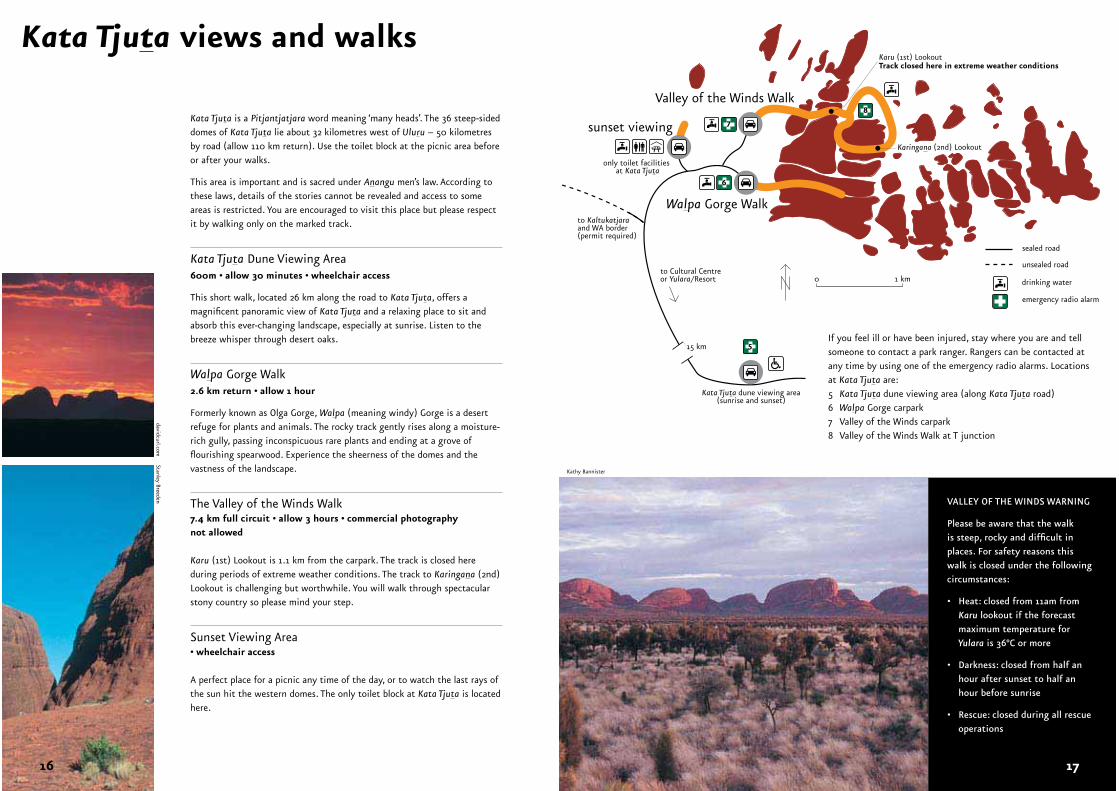
Kata Tjuta is a Pitjantjatjara word meaning ‘many heads’. The 36 steep-sided domes of Kata Tjuta lie about 32 kilometres west of Uluru – 50 kilometresby road (allow 110 km return). Use the toilet block at the picnic area before or after your walks.
This area is important and is sacred under Anangu men’s law. According to these laws, details of the stories cannot be revealed and access to some areas is restricted. You are encouraged to visit this place but please respect it by walking only on the marked track.
Kata Tjuta Dune Viewing Area600m • allow 30 minutes • wheelchair access
This short walk, located 26 km along the road to Kata Tjuta, offers a magnificent panoramic view of Kata Tjuta and a relaxing place to sit and absorb this ever-changing landscape, especially at sunrise. Listen to the breeze whisper through desert oaks.
Walpa Gorge Walk2.6 km return • allow 1 hour
Formerly known as Olga Gorge, Walpa (meaning windy) Gorge is a desert refuge for plants and animals. The rocky track gently rises along a moisture-rich gully, passing inconspicuous rare plants and ending at a grove of flourishing spearwood. Experience the sheerness of the domes and the vastness of the landscape.
The Valley of the Winds Walk7.4 km full circuit • allow 3 hours • commercial photography not allowed
Karu (1st) Lookout is 1.1 km from the carpark. The track is closed here during periods of extreme weather conditions. The track to Karingana (2nd) Lookout is challenging but worthwhile. You will walk through spectacular stony country so please mind your step.
Sunset Viewing Area• wheelchair access
A perfect place for a picnic any time of the day, or to watch the last rays of the sun hit the western domes. The only toilet block at Kata Tjuta is located here.
Kata Tjuta views and walks
davidcurl.comStanley Breeden
Kathy Bannister
If you feel ill or have been injured, stay where you are and tell someone to contact a park ranger. Rangers can be contacted at any time by using one of the emergency radio alarms. Locationsat Kata Tjuta are:5 Kata Tjuta dune viewing area (along Kata Tjuta road)6 Walpa Gorge carpark7 Valley of the Winds carpark 8 Valley of the Winds Walk at T junction
VALLEY OF THE WINDS WARNING
Please be aware that the walk is steep, rocky and difficult in places. For safety reasons this walk is closed under the following circumstances:
• Heat: closed from 11am from Karu lookout if the forecast maximum temperature for Yulara is 36°C or more
• Darkness: closed from half an hour after sunset to half an hour before sunrise
• Rescue: closed during all rescue operations
16 17
Tjukurpa is the foundation of our culture. Just as a house needs to stand on strong foundations, so our way of life stands on Tjukurpa. It is our traditional law guiding us today.
Some people try to translate Tjukurpa (pronounced like ‘chook-orr-pa’) as ‘Dreaming’ or ‘Dreamtime’. This does not seem right to us – Tjukurpa is real, not imaginary or fleeting. We prefer to use the Pitjantjatjara word ‘Tjukurpa’ or the Yankunytjatjara word ‘Wapar’ (pronounced like ‘wop-arr’) which contain the deeper, complex meaning.
Tjukurpa is our religious heritage, explaining our existence and guiding our daily life. Like religions anywhere in the world, the Tjukurpa provides answers to important questions, the rules for behaviour and for living together. It is the law for caring for one another and for the land that supports our existence. Tjukurpa tells of the relationships between people, plants, animals and the physical features of the land.
Knowledge of how these relationships came to be, what they mean and how they must be carried on is explained in the Tjukurpa.
Tjukurpa refers to the past, the present and the future at the same time. It refers to the time when Tjukuritja (ancestral beings), created the world as we know it. Tjukurpa also refers to Anangu religion, law, relationships and moral systems. Anangu life today revolves around Tjukurpa.
Tjukurpa
Nintiringula kamila tjamula tjanalanguru. Wiruralanintiringu munula watarkur-intjawiya. Nintiringula tjilpi munu pampa nguraritja tjutanguru, munula rawangku tjukurpa kututungka munu katangka kanyilku. Ngura nyangakula ninti – nganananinti.
We learnt from our grand-mothers and grandfathers and their generation. We learnt well and we have not forgotten. We’ve learnt from the old people of this place, and we’ll always keep the Tjukurpa in our hearts and minds. We know this place – we are ninti, knowledgeable.
—© Barbara Tjikatu, Traditional Owner
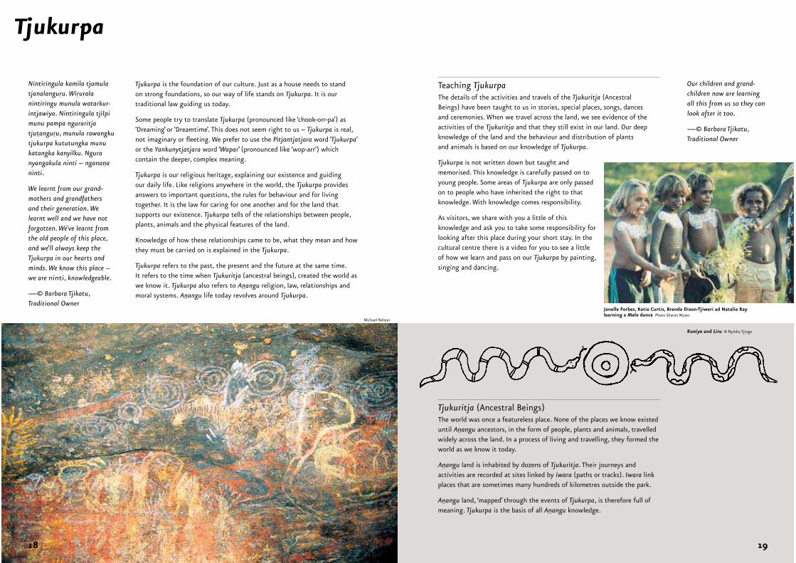
Teaching TjukurpaThe details of the activities and travels of the Tjukuritja (Ancestral Beings) have been taught to us in stories, special places, songs, dances and ceremonies. When we travel across the land, we see evidence of the activities of the Tjukuritja and that they still exist in our land. Our deepknowledge of the land and the behaviour and distribution of plants and animals is based on our knowledge of Tjukurpa.
Tjukurpa is not written down but taught and memorised. This knowledge is carefully passed on to young people. Some areas of Tjukurpa are only passed on to people who have inherited the right to that knowledge. With knowledge comes responsibility.
As visitors, we share with you a little of this knowledge and ask you to take some responsibility for looking after this place during your short stay. In the cultural centre there is a video for you to see a little of how we learn and pass on our Tjukurpa by painting, singing and dancing.
Tjukuritja (Ancestral Beings)The world was once a featureless place. None of the places we know existed until Anangu ancestors, in the form of people, plants and animals, travelled widely across the land. In a process of living and travelling, they formed the world as we know it today.
Anangu land is inhabited by dozens of Tjukuritja. Their journeys and activities are recorded at sites linked by iwara (paths or tracks). Iwara link places that are sometimes many hundreds of kilometres outside the park.
Anangu land, ‘mapped’ through the events of Tjukurpa, is therefore full of meaning. Tjukurpa is the basis of all Anangu knowledge.
Our children and grand-children now are learning all this from us so they can look after it too.
—© Barbara Tjikatu, Traditional Owner
Michael Nelson
Kuniya and Liru © Nyinku Tjingo
Janelle Forbes, Katie Curtis, Brenda Dixon-Tjiweri ad Natalie Raylearning a Mala dance Photo Sharon Wyatt
18 19
Uluru and Kata Tjuta have been part of our homeland for tens of thousands of years. In the past, although we did not live here all the time, our people visited often. We travelled over huge areas of country, hunting, gathering and foraging for food. We also visited important areas and passed on stories, performed ceremonies, looked after water-holes and burnt old spinifex.
Now that Piranpa have come here, some aspects of our lives have been changed forever. We live in communities, but often travel to our other homelands and visit relatives in western desert communities. We still like bush foods and hunt for them with our families. Our hunting tools are modern, but the bush foods, such as kangaroo and bush figs, are the same foods our people have always hunted.
Nganampa ngura
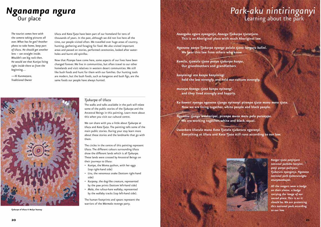
Tjukurpa of UluruThe walks and talks available in the park will relate some of the public stories of the Tjukurpa and the Ancestral Beings in this painting. Learn more about this when you visit our cultural centre.
We can share with you a little about Tjukurpa at Uluru and Kata Tjuta. The painting tells some of the main public stories. During your stay learn more about these stories and the landmarks that go with them.
The circles in the centre of this painting represent Uluru. The different colours surrounding Ulurushow the different lands which is all Tjukurpa. These lands were crossed by Ancestral Beings on their journeys to Uluru: • Kuniya, the Woma python, with her eggs
(top right-hand side)• Liru, the venomous snake (bottom right-hand
side)• Kurpany, the dog-like creature, represented
by the paw prints (bottom left-hand side)• Mala, the rufous-hare wallaby, represented
by the wallaby tracks (top left-hand side).
The human footprints and spears represent the warriors of the Warmala revenge party.
Park-aku nintiringanyi
Ananguku ngura nyangatja, Anangu Tjukurpa tjutatjara.This is an Aboriginal place with much Aboriginal law.
Nganana panya Tjukurpa nyanga palula tjana-languru kulini.We hear this law from others who know.
Kamilu, tjamulu tjana panya tjukurpa kunpu,Our grandmothers and grandfathers
kanyiningi ara kunpu kanyiningiheld the law strongly, and held our culture strongly,
munuya Anangu tjuta kunpu nyinangi.and they lived strongly and happily.
Ka kuwari nyanga nganana tjungu nyinanyi piranpa tjuta munu maru tjuta.Now we are living together, white people and black people.
Nganana tjungu waakaripai, piranpa munu maru palu purunypa.We are working together, white and black, equal.
Uwankara Ulurula munu Kata Tjutala tjukaruru ngaranyi.Everything at Uluru and Kata Tjuta still runs according to our law.
Our place
The tourist comes here with the camera taking pictures all over. What has he got? Another photo to take home, keep part of Uluru. He should get another lens – see straight inside. Wouldn’t see big rock then. He would see that Kuniya living right inside there as from the beginning…
—© Kunmanara, Traditional Owner
Ranger tjuta patjitjara national parkaku kanyini, patji panya pulitjara. Tjukaruru nyangatja. Nganananational park tjukarurungkuatunymankupai.
All the rangers wear a badge on their sleeve, a badge carrying the image of our sacred place. This is as it should be. We are protecting this national park according to our law.
Learning about the park
Tjukurpa of Uluru © Malya Teamay
20 21
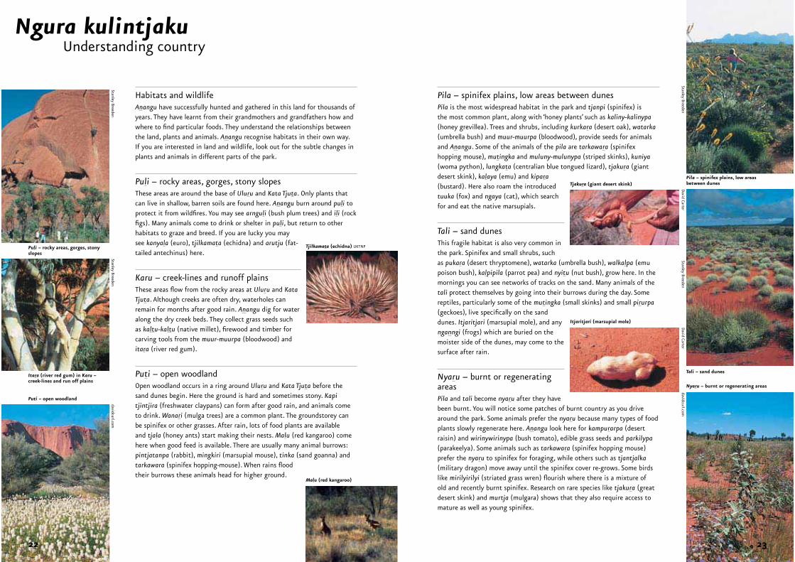
Habitats and wildlifeAnangu have successfully hunted and gathered in this land for thousands of years. They have learnt from their grandmothers and grandfathers how and where to find particular foods. They understand the relationships between the land, plants and animals. Anangu recognise habitats in their own way. If you are interested in land and wildlife, look out for the subtle changes in plants and animals in different parts of the park.
Puli – rocky areas, gorges, stony slopesThese areas are around the base of Uluru and Kata Tjuta. Only plants that can live in shallow, barren soils are found here. Anangu burn around puli to protect it from wildfires. You may see arnguli (bush plum trees) and ili (rock figs). Many animals come to drink or shelter in puli, but return to other habitats to graze and breed. If you are lucky you may see kanyala (euro), tjilkamata (echidna) and arutju (fat-tailed antechinus) here.
Karu – creek-lines and runoff plainsThese areas flow from the rocky areas at Uluru and KataTjuta. Although creeks are often dry, waterholes can remain for months after good rain. Anangu dig for water along the dry creek beds. They collect grass seeds such as kaltu-kaltu (native millet), firewood and timber for carving tools from the muur-muurpa (bloodwood) and itara (river red gum).
Puti – open woodlandOpen woodland occurs in a ring around Uluru and Kata Tjuta before the sand dunes begin. Here the ground is hard and sometimes stony. Kapitjintjira (freshwater claypans) can form after good rain, and animals come to drink. Wanari (mulga trees) are a common plant. The groundstorey can be spinifex or other grasses. After rain, lots of food plants are available and tjala (honey ants) start making their nests. Malu (red kangaroo) come here when good feed is available. There are usually many animal burrows: pintjatanpa (rabbit), mingkiri (marsupial mouse), tinka (sand goanna) and tarkawara (spinifex hopping-mouse). When rains flood their burrows these animals head for higher ground.
Pila – spinifex plains, low areas between dunesPila is the most widespread habitat in the park and tjanpi (spinifex) is the most common plant, along with ‘honey plants’ such as kaliny-kalinypa(honey grevillea). Trees and shrubs, including kurkara (desert oak), watarka(umbrella bush) and muur-muurpa (bloodwood), provide seeds for animals and Anangu. Some of the animals of the pila are tarkawara (spinifex hopping mouse), mutingka and muluny-mulunypa (striped skinks), kuniya(woma python), lungkata (centralian blue tongued lizard), tjakura (giant desert skink), kalaya (emu) and kipara(bustard). Here also roam the introduced tuuka (fox) and ngaya (cat), which search for and eat the native marsupials.
Tali – sand dunesThis fragile habitat is also very common in the park. Spinifex and small shrubs, such as pukara (desert thryptomene), watarka (umbrella bush), walkalpa (emu poison bush), kalpipila (parrot pea) and nyitu (nut bush), grow here. In the mornings you can see networks of tracks on the sand. Many animals of the tali protect themselves by going into their burrows during the day. Some reptiles, particularly some of the mutingka (small skinks) and small pirurpa(geckoes), live specifically on the sand dunes. Itjaritjari (marsupial mole), and any nganngi (frogs) which are buried on the moister side of the dunes, may come to the surface after rain.
Nyaru – burnt or regenerating areasPila and tali become nyaru after they have been burnt. You will notice some patches of burnt country as you drive around the park. Some animals prefer the nyaru because many types of food plants slowly regenerate here. Anangu look here for kampurarpa (desert raisin) and wirinywirinypa (bush tomato), edible grass seeds and parkilypa(parakeelya). Some animals such as tarkawara (spinifex hopping mouse) prefer the nyaru to spinifex for foraging, while others such as tjantjalka(military dragon) move away until the spinifex cover re-grows. Some birds like mirilyirilyi (striated grass wren) flourish where there is a mixture of old and recently burnt spinifex. Research on rare species like tjakura (great desert skink) and murtja (mulgara) shows that they also require access to mature as well as young spinifex.
Ngura kulintjaku
Puli – rocky areas, gorges, stony slopes
Itara (river red gum) in Karu –creek-lines and run off plains
Puti – open woodland
Tjilkamata (echidna) UKTNP
Malu (red kangaroo)
Tjakura (giant desert skink)
Itjaritjari (marsupial mole)
Pila – spinifex plains, low areas between dunes
Tali – sand dunes
Nyaru – burnt or regenerating areas
Understanding country
Stanley BreedenStanley Breeden
davidcurl.com
David Carter
David Carter
Stanley BreedenStanley Breeden
davidcurl.com
22 23
Wanitjunkupai – April, May
The beginning of the cold weather. This is when the park’s reptiles hibernate (Wanitjunkupai literally means hibernate). Tjuntalpa (clouds) start around April but usually don’t bring rain. They come from the south, brought mainly by westerly winds. Tjuntalpa sit low over the hills until late in the day.
Wari– late May, June, July
The cold time when there is nyinnga (frost) and kulyarkulyarpa (mist or dew) every morning, but little rain. Seasonal changes in the western desert are subtle.
We all know that it can get very hot in summer (average temperature 37.8°C). Few people realise that it can also get very cold at night in winter (average temperature 4.7°C). But here there is more to seasons than spring, summer, autumn and winter. Anangu, the Indigenous people of the landscape, notice a lot more of these changes than do visitors to their land. Some of these are described here.
‘Anangu don’t go by piranpadates, we only go by our own seasons… We know which fruits and foods we get during our seasons – that’s what is important to us.’
—© Barbara Tjikatu, Traditional Owner
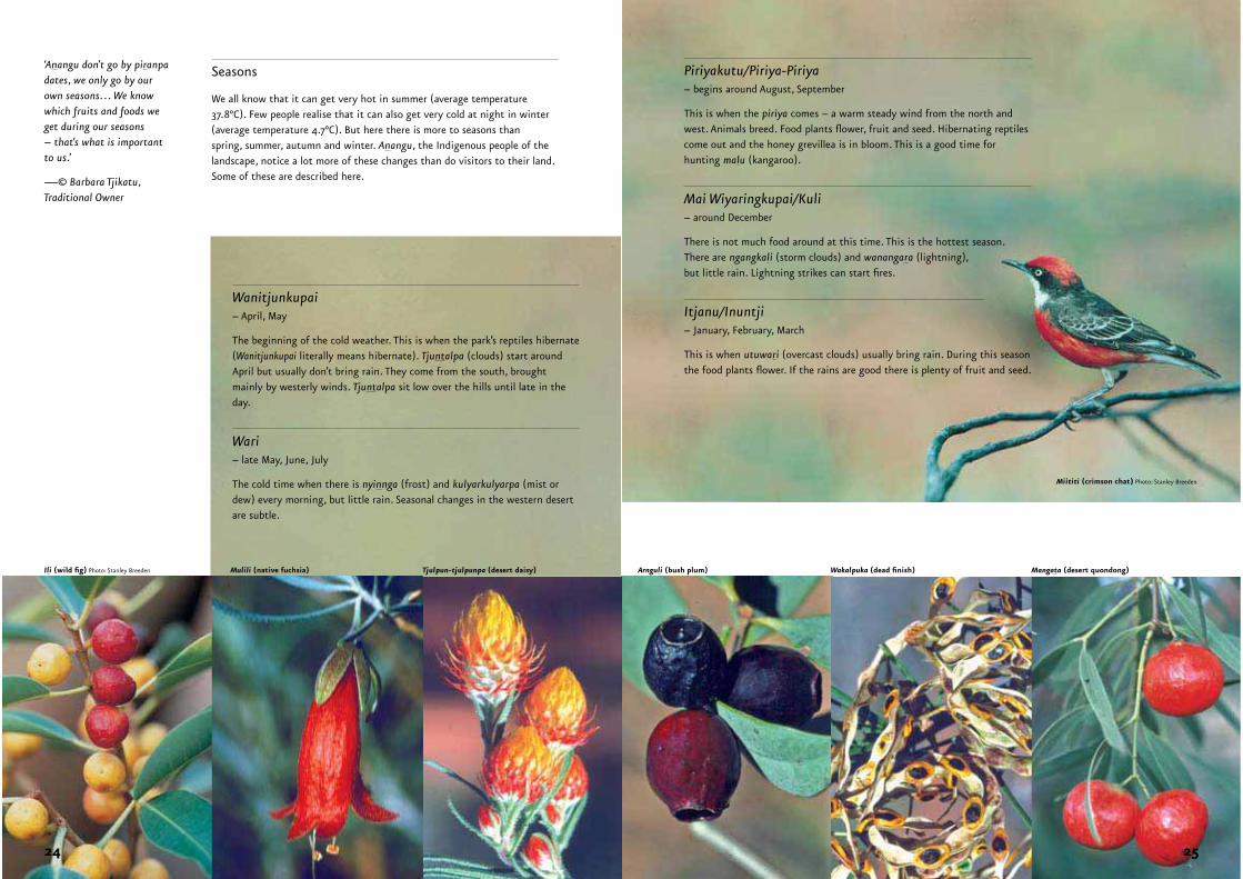
Seasons Piriyakutu/Piriya-Piriya– begins around August, September
This is when the piriya comes – a warm steady wind from the north and west. Animals breed. Food plants flower, fruit and seed. Hibernating reptiles come out and the honey grevillea is in bloom. This is a good time for hunting malu (kangaroo).
Mai Wiyaringkupai/Kuli– around December
There is not much food around at this time. This is the hottest season. There are ngangkali (storm clouds) and wanangara (lightning), but little rain. Lightning strikes can start fires.
Itjanu/Inuntji– January, February, March
This is when utuwari (overcast clouds) usually bring rain. During this season the food plants flower. If the rains are good there is plenty of fruit and seed.
Ili (wild fig) Photo: Stanley Breeden
Miititi (crimson chat) Photo: Stanley Breeden
Mulili (native fuchsia) Tjulpun-tjulpunpa (desert daisy) Arnguli (bush plum) Wakalpuka (dead finish) Mangata (desert quondong)
24 25
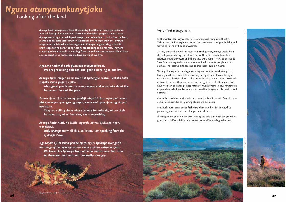
Anangu land management kept the country healthy for many generations. A lot of damage has been done since non-Aboriginal people arrived. Today, Anangu work together with park rangers and scientists to look after the land, plants and animals according to traditional law. Anangu train the piranparangers in traditional land management. Piranpa rangers bring scientific knowledge to the park. Young Anangu are training to be rangers. They are studying science as well as learning from the old men and women. We all have a responsibility to look after the land on which we live.
In the winter months you may notice dark smoke rising into the sky. This is how the first explorers learnt that there were other people living and travelling in the arid lands of Australia.
As they travelled around the country in small groups, Anangu would burn the old spinifex during the colder months. They did this to show their relatives where they were and where they were going. They also burned to ‘clean’ the country and make way for new food plants for people and for animals. The local wildlife adapted to this patch–burning method.
Today park rangers and Anangu work together to recreate the old patch burning method. This involves selecting the right time of year, the right weather and the right place. It also means burning around vulnerable stands of trees to protect them and selecting the right areas of old spinifex that have not been burnt for perhaps fifteen to twenty years. Today’s rangers use drip torches, rake hoes, helicopters and satellite imagery to plan and control burning.
Controlled patch burns also help to protect the land from wild fires that can occur in summer due to lightning strikes and accidents.
Previously burnt areas act as firebreaks when wild fires break out, thus preventing mass destruction of important habitats.
If management burns do not occur during the cold time then the growth of grass and spinifex builds up – a destructive wildfire waiting to happen.
Waru (fire) management ‘All the men and woman are working with the rangers and teaching them about waru work (patch burning) so that the country is growing properly and no big fires come here.’
—© Kunmanara, Traditional Owner
Ngura atunymankunytjaku
Nganana national park tjukaruru atunymankupai.We are protecting this national park according to our law.
Anangu tjuta ranger munu scientist tjutangka nintini Parkaku kuka tjutaku munu punu tjutaku.
Aboriginal people are training rangers and scientists about the fauna and flora of the park.
Paluru tjana tjalkultjunanyi yaaltji mingkiri tjuta nyinapai, munu piti tjanampa nyaangka ngarapai, munu mai nyaa tjana ngalkupai, uwankara. They are telling them where to look for animals, where their
burrows are, what food they eat – everything.
Anangu kutju ninti. Ka kulila, ngayalu kuwari Tjukurpa-nguruwangkanyi.
Only Anangu know all this. So listen, I am speaking from the Tjukurpa now.
Ngananala tjilpi munu pampa tjuta-nguru Tjukurpa nyangatja nintiringanyi ka nganana kulira munu pulkara witira kanyini.
We learn this Tjukurpa from old men and women. We listen to them and hold onto our law really strongly.
Ngiyari (thorny devil) Photo: Stanley Breeden
Stanley Breedendavidcurl.com
Looking after the land
26 27
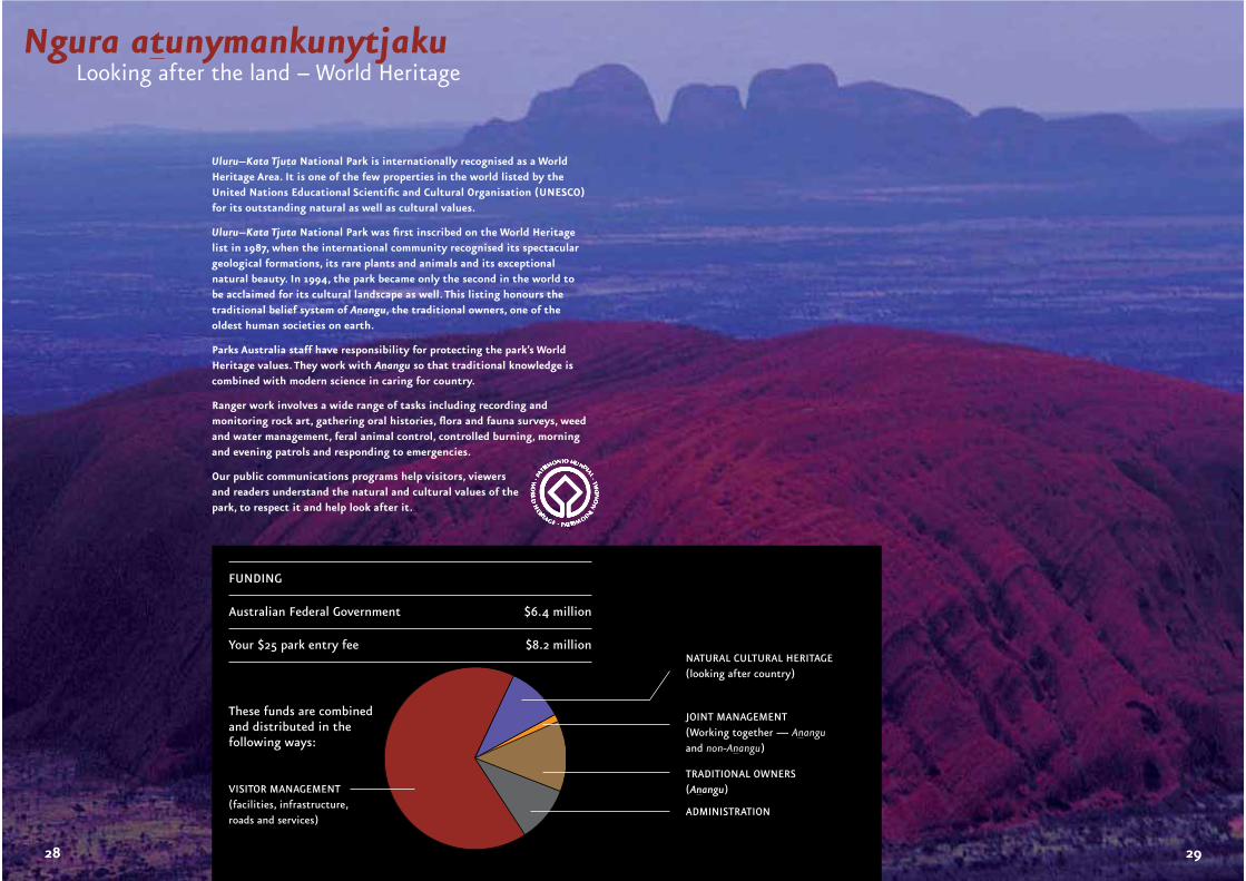
Ngura atunymankunytjakuLooking after the land – World Heritage
Uluru–Kata Tjuta National Park is internationally recognised as a World Heritage Area. It is one of the few properties in the world listed by the United Nations Educational Scientific and Cultural Organisation (UNESCO)for its outstanding natural as well as cultural values.
Uluru–Kata Tjuta National Park was first inscribed on the World Heritage list in 1987, when the international community recognised its spectacular geological formations, its rare plants and animals and its exceptional natural beauty. In 1994, the park became only the second in the world to be acclaimed for its cultural landscape as well. This listing honours the traditional belief system of Anangu, the traditional owners, one of the oldest human societies on earth.
Parks Australia staff have responsibility for protecting the park’s World Heritage values. They work with Anangu so that traditional knowledge is combined with modern science in caring for country.
Ranger work involves a wide range of tasks including recording and monitoring rock art, gathering oral histories, flora and fauna surveys, weed and water management, feral animal control, controlled burning, morning and evening patrols and responding to emergencies.
Our public communications programs help visitors, viewers and readers understand the natural and cultural values of the park, to respect it and help look after it.
FUNDING
Australian Federal Government $6.4 million
Your $25 park entry fee $8.2 million
These funds are combined and distributed in the following ways:
NATURAL CULTURAL HERITAGE (looking after country)
JOINT MANAGEMENT(Working together — Ananguand non-Anangu)
VISITOR MANAGEMENT(facilities, infrastructure, roads and services)
TRADITIONAL OWNERS(Anangu)
ADMINISTRATION
28 29
camp only at Yulara or Curtin Springs, not in the Park r12.28
cook on the barbecues provided and do not light any other fire within the Park r12.30
leave firearms, weapons, nets and the like outside the Park r12.18
stay on roads and signposted walking tracks at all times r12.55
observe speed limits and other Northern Territory road laws r12.43
only park your vehicle in areas which have parking signs r12.44
do not park your vehicle where “ No Parking” signs are present r12.44
do not stop your vehicle where “ No Stopping” signs are present r12.44
do not stop your vehicle where double or a single yellow line/s are present on the road edge r12.44
do not rock-climb, abseil, BASE jump or parachute in the Park r12.26
respect others and do not annoy them, especially with loud noise and/or disorderly, offensive or indecent behaviour r12.27
Welcome to Uluru-Kata Tjuta National Park. Anangu traditional owners have looked after this place for tens of thousands of years. Since becoming a National Park, Park Rangers have been here to help look after this place too. Remember you are visiting a special World Heritage Area that is valued for its landscape, flora, fauna and for its rich living culture. We welcome you to explore, enjoy and learn about the Park and also to help look after it. The following summary of Park regulations are based on legislation called the Environment Protection and Biodiversity Conservation (EPBC) Act and Regulations. You can help us to look after this special place by following them.
Please EPBC
stop at the Park Entry Station to show or purchase your Park Use Ticket each time you enter the Park. r12.54
validate your Park Use Ticket by printing your full name on it and ensure Park Entry Station staff date stamp your ticket r12.61
show your Park Use Ticket if a Park Ranger asks r12.61
follow any safety direction given by a Park Ranger r12.25
give your name and address if a Park Ranger asks for it r14.01
do not bring plant material (including firewood, domestic plants, seeds) or animals into the Park rr12.19/20
do not disturb or take away rocks, soil or sand in or from the Park rr12.16/27
stay safe by choosing not to climb Uluru or walk the Valley of the Winds track if closed by a Park Ranger
contact the Park’s Cultural Centre Information Desk about the many other Park activities available: Ph: +61 8 8956 1128 – Fax: +61 8 8956 2360 Email: [email protected] Web: www.deh.gov.au/parks/uluru r12.23
do not enter Mutitjulu Community without permission
respect Anangu and Park staff by not photographing them without permission
respect sacred sites by not entering or photographing them rr12.23/24
apply for a permit before taking and using an image (photography, filming/video, artwork) of Uluru-Kata Tjuta National Park for commercial gain (It is not permitted to take images of sacred sites or within the Cultural Centre complex) rr12.24/38
apply for a permit before doing anything for commercial purposes. This includes taking tours and selling or hiring anything (that is to be used in the park) and photography, filming/video, artwork or sound recording for commercial purposes Act s354, rr12.24/36
show your permit to carry out an activity within the Park if a Park Ranger asks rr12.59/14.01
observe and/or photograph plants and animals, but do not feed, touch, damage or take them Act s354
Ngura pulkanya atunmananyiLooking after this special place
Uluru-Kata Tjuta National Park is a Commonwealth Reserve under the Environment Protection and Biodiversity Conservation Act 1999. As a result, the laws in Uluru-Kata Tjuta differ in some ways from other areas within the Northern Territory. For more information please call the Cultural Centre on (08) 8956 1128.
For any information about the above summary of Park Regulations or the Park in general, please talk to Park Staff and ensure you visit the Park’s Cultural Centre.
Copies of the Environment Protection and Biodiversity Conservation (EPBC) Act 1999 and the Environment Protection and Biodiversity Conservation (EPBC) Regulations 2000 can be viewed at the Park’s Cultural Centre Information desk. For all legal purposes the complete EPBC Act and Regulations should be consulted.
Copies of this legislation may be obtained from:
• Department of the Environment and Heritage web-site: http://www.deh.gov.au/epbc/ (follow the prompts)
• CANPRINT Ph: 1300 656 863
EPBC Act (Reprint 2, 2004) - code: 0331823 - $37.25 plus postage
EPBC Regulations (Reprint 1, 2002) - code: 0220083 - $17.80 plus postage
EPBC Amendment Regulations 2003 (No.1) – 0332471 - $4.30 plus postage
Note: Information was correct at time of printing – October 2005, however future changes may occur.
30 31
Pitjantjatjara/Yankunytjatjara
Approximatepronounciation
English meaning
Anangu Arn-ang-oo Aboriginal people of westerndesert
atunymankuntjaku ar-toon-mun-koon-jark-oo
looking after
ininti in-nin-tea red bean of the bean tree
inma in-ma dance, ceremony
itjanu/inuntji e-jan-oo/e-noon-jee flower
karu car-oo creek
Kata Tjuta Kar-ta choo-ta many heads, name of 36 dome rock outcrop
Kuniya Koon-i-ya woma python
Kunmanara Koon-man-arr-a substitute name used instead of the name of a deceasedperson
Kurpany Core-pan devil dog, monster of theMala story
Liru Leer-oo poisonous snake: western brown snake, king brownsnake etc
mai may fruit and vegetable food
Mala Marl-a rufous-hare wallaby
maruku mar-oo-ku for black people – literally, Maru = black, ku = for
Mutitjulu Moot-it-joo-loo name of waterhole at base of Uluru, name of localAboriginal community
nganampa ngan-am-pa ours (many people including the speaker)
nganana ngan-arn-a all of us
ngura ngoo-rra home, camp, place
Nguraritja Ngoo-rrar-i-ja Traditional Owner
palya parl-ya hello/goodbye/thank you/finish
pila pill-ar spinifex plains
The letters r, n, l and t existin Pitjantjatjara/ Yankunyt-jatjara spelling system anduse similar sounds as in English.
The r with the underlinesounds just like the English‘r’, but the r without theunderline sounds more likethe rolled Scottish ‘rr’.
When the letters n, l, and t are underlined their sounds change. Linguists tell us that this denotes sounds that approximate rn, rland rt.
Almost without exception,the accent is placed on the first syllable of words.
piranpa peer-an-pa non-Aboriginal people(literally white)
piriya peer-ee-ya warm consistent wind from the north and west
puli poor-lee rock
puti poor-tea woodland, bushland
tali tar-lee sand dunes
tatintja tar-tin-ja climb
tjukuritja chook-orr-icha creation ancestors, ancestralbeings
Tjukurpa/Wapar Chook-orr-pa/wop-arr
complex meaning – creation time, lore, law, way of life,story
tjunguringkula choong-orr-ing-koola
come together
Uluru Ool-or-roo name of monolith
waakaripai wark-karr-i-pay work all the time (habitually)
walkatjara warl-ka-jar-ra having marks, literally walka = marks, -tjara = having
walpa wharl-pa wind
warmala wah-marl-a traditional revenge party
wari wah-rree cold
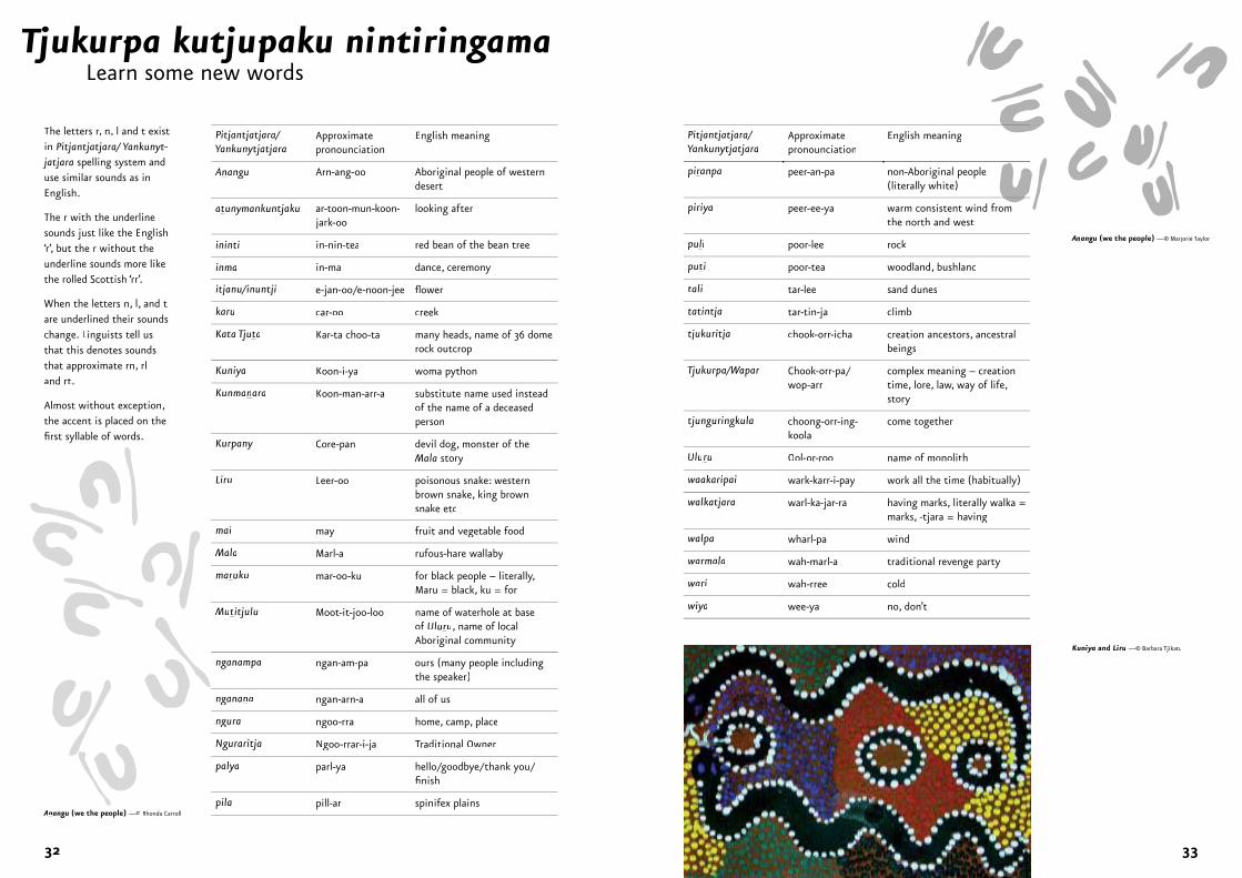
wiya wee-ya no, don’t
Pitjantjatjara/Yankunytjatjara
Approximatepronounciation
English meaning
Tjukurpa kutjupaku nintiringamaLearn some new words
jj
Kuniya and Liru —© Barbara TjikatuT
Anangu (we the people) —© Marjorie TaylorTT
Anangu (we the people) —© Rhonda Carroll
32 33
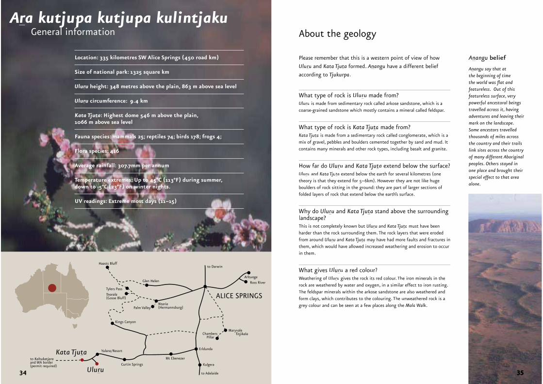
General informationAra kutjupa kutjupa kulintjaku
Please remember that this is a western point of view of how
Uluru and Kata Tjuta formed. Anangu have a different belief
according to Tjukurpa.
What type of rock is Uluru made from?Uluru is made from sedimentary rock called arkose sandstone, which is a coarse-grained sandstone which mostly contains a mineral called feldspar.
What type of rock is Kata Tjuta made from?Kata Tjuta is made from a sedimentary rock called conglomerate, which is amix of gravel, pebbles and boulders cemented together by sand and mud. It contains many minerals and other rock types, including basalt and granite.
How far do Uluru and Kata Tjuta extend below the surface?Uluru and Kata Tjuta extend below the earth for several kilometres (onetheory is that they extend for 5–6km). However they are not like huge boulders of rock sitting in the ground: they are part of larger sections of folded layers of rock that extend below the earth’s surface.
Why do Uluru and Kata Tjuta stand above the surrounding landscape?This is not completely known but Uluru and Kata Tjuta must have been harder than the rock surrounding them. The rock layers that were eroded from around Uluru and Kata Tjuta may have had more faults and fractures in them, which would have allowed increased weathering and erosion to occurin them.
What gives Uluru a red colour?Weathering of Uluru gives the rock its red colour. The iron minerals in therock are weathered by water and oxygen, in a similar effect to iron rusting.The feldspar minerals within the arkose sandstone are also weathered andform clays, which contributes to the colouring. The unweathered rock is a grey colour and can be seen at a few places along the Mala Walk.
Anangu belief
Anangu say that at the beginning of timethe world was flat andfeatureless. Out of this featureless surface, very powerful ancestoral beingstravelled across it, havingadventures and leaving their mark on the landscape. Some ancestors travelled thousands of miles acrossthe country and their trails link sites across the country of many different Aboriginal peoples. Others stayed in one place and brought their special effect to that areaalone.
About the geology
Erldunda
Kulgera
Mt Ebenezer
Curtin Springs
MaryvaleTitjikalaChambers
Pillar
Yulara/ResortKata Tjuta
Uluru
Haasts Bluff
Tylers Pass
Tnorala(Gosse Bluff)
Glen Helen
Ntaria(Hermannsburg)Palm Valley
ALICE SPRINGS
Arltunga
Ross River
to Darwin
to Adelaide
Kings Canyon
to Kaltukatjaraand WA border(permit required)
Location: 335 kilometres SW Alice Springs (450 road km)
Size of national park: 1325 square km
Uluru height: 348 metres above the plain, 863 m above sea level
Uluru circumference: 9.4 km
Kata Tjuta: Highest dome 546 m above the plain, 1066 m above sea level
Fauna species: mammals 25; reptiles 74; birds 178; frogs 4;
Flora species: 416
Average rainfall: 307.7mm per annum
Temperature extremes: Up to 45°C (113°F) during summer, down to -5°C (23°F) on winter nights.
UV readings: Extreme most days (11–15)
34
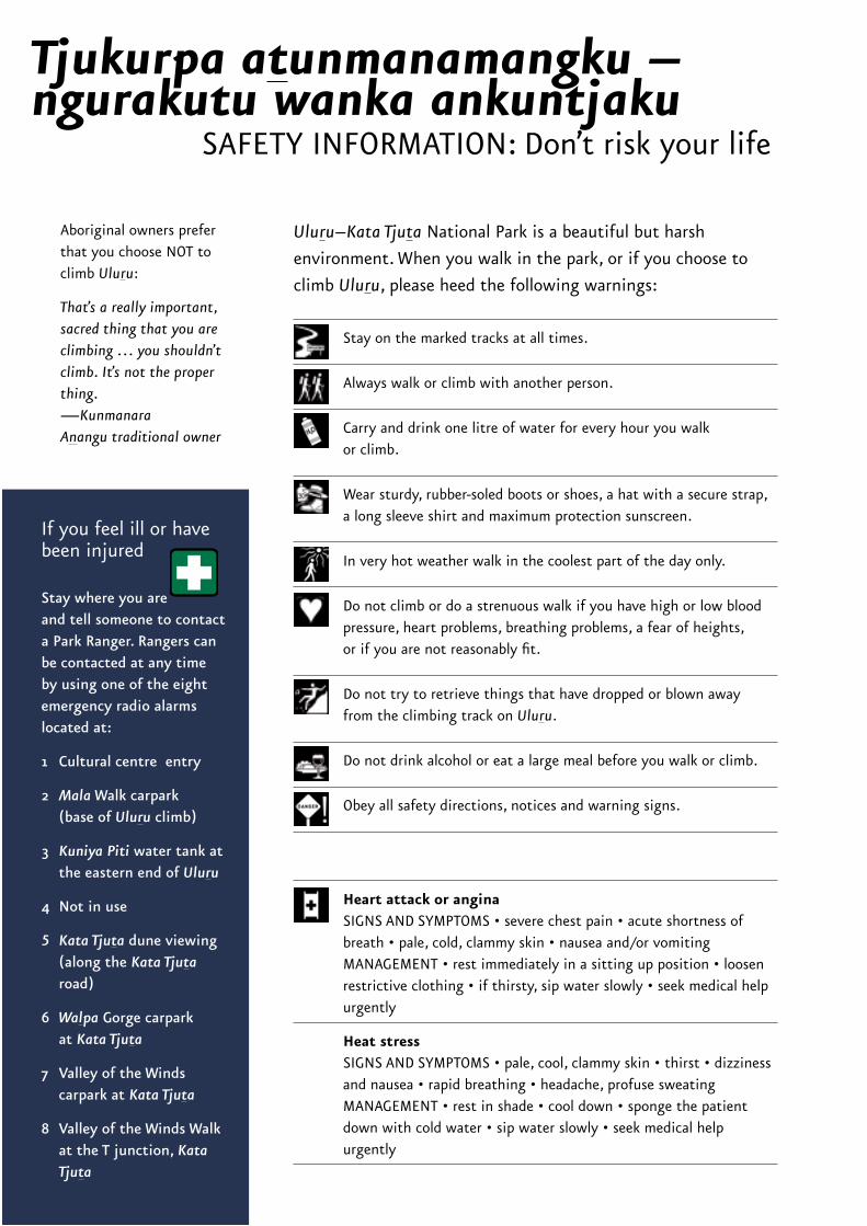
Uluru–Kata Tjuta National Park is a beautiful but harsh
environment. When you walk in the park, or if you choose to
climb Uluru, please heed the following warnings:
Aboriginal owners prefer that you choose NOT to climb Uluru:
That’s a really important, sacred thing that you are climbing … you shouldn’t climb. It’s not the proper thing.—KunmanaraAnangu traditional owner
If you feel ill or have been injured
Stay where you are and tell someone to contact a Park Ranger. Rangers can be contacted at any time by using one of the eight emergency radio alarms located at:
1 Cultural centre entry
2 Mala Walk carpark (base of Uluru climb)
3 Kuniya Piti water tank at the eastern end of Uluru
4 Not in use
5 Kata Tjuta dune viewing (along the Kata Tjutaroad)
6 Walpa Gorge carpark at Kata Tjuta
7 Valley of the Windscarpark at Kata Tjuta
8 Valley of the Winds Walkat the T junction, KataTjuta
Stay on the marked tracks at all times.
Always walk or climb with another person.
Carry and drink one litre of water for every hour you walk or climb.
Wear sturdy, rubber-soled boots or shoes, a hat with a secure strap, a long sleeve shirt and maximum protection sunscreen.
In very hot weather walk in the coolest part of the day only.
Do not climb or do a strenuous walk if you have high or low blood pressure, heart problems, breathing problems, a fear of heights, or if you are not reasonably fit.
Do not try to retrieve things that have dropped or blown away from the climbing track on Uluru.
Do not drink alcohol or eat a large meal before you walk or climb.
Obey all safety directions, notices and warning signs.
Heart attack or anginaSIGNS AND SYMPTOMS • severe chest pain • acute shortness of breath • pale, cold, clammy skin • nausea and/or vomiting MANAGEMENT • rest immediately in a sitting up position • loosen restrictive clothing • if thirsty, sip water slowly • seek medical help urgently
Heat stressSIGNS AND SYMPTOMS • pale, cool, clammy skin • thirst • dizziness and nausea • rapid breathing • headache, profuse sweating MANAGEMENT • rest in shade • cool down • sponge the patient down with cold water • sip water slowly • seek medical help urgently
Tjukurpa atunmanamangku – ngurakutu wanka ankuntjaku
SAFETY INFORMATION: Don’t risk your life