Embed Size (px)
Citation preview
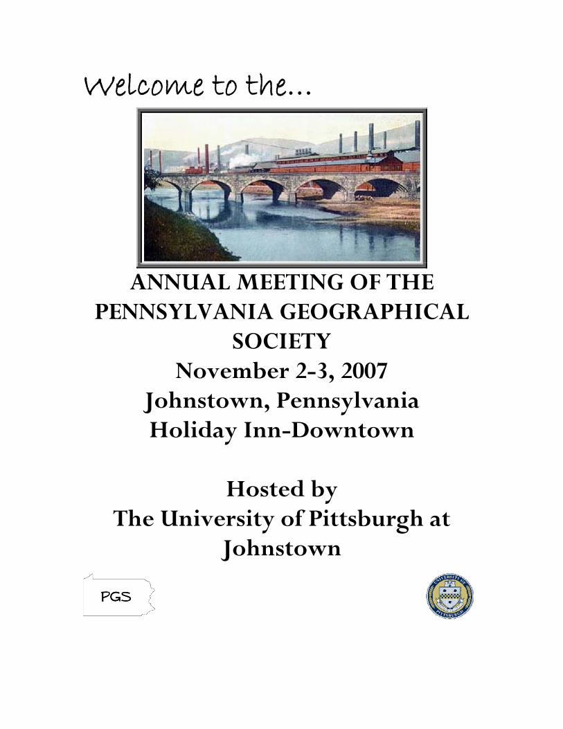
Welcome to the…
ANNUAL MEETING OF THE
PENNSYLVANIA GEOGRAPHICAL SOCIETY
November 2-3, 2007 Johnstown, Pennsylvania Holiday Inn-Downtown
Hosted by
The University of Pittsburgh at Johnstown
WELCOME!
Johnstown is again the host city for the annual meeting of the Pennsylvania Geographical Society. The meetings were last held here in 2001, shortly after the tragedies of “September 11th”. What has changed in the area since then? There have been several renovations and some completely new projects completed since 2001. One of those “renovations” is the Heritage Discovery Center, the location of the Friday banquet. Housed in an old brewery, the center seeks to educate the public in the rich ethnic and economic history of the immediate area. In addition, both the Point Stadium and the War Memorial Arena have seen significant renovations, the Pasquerilla Conference Center has been opened, and the restaurant at the top of the Incline Plane (City View) is back in business under a new owner. While the research presentations, workshops and panel discussions are all being held in the same rooms as in 2001, we will find younger colleagues and many students bringing fresh ideas and innovations to the presentations this year. We will also get to visit with a few active members who have moved on to other institutions beyond our area, or have begun to enjoy their retirement. The interaction between the enthusiasm of youth and the wisdom of the established professionals is always a key component of the dynamics of PGS meetings. In addition to the 2007 Conference Organizing Committee and the UPJ student assistants (see following pages), I’d like to thank the following for additional help along the way: Jim Alexander (Social Science Division Chair, UPJ), Dan Gotwald (UPJ Print Shop), Tim Hawkins (Shippensburg), Linda Just (UPJ User Services), Mary Lavine (UPJ), Kyle Olmstead (California), Joe Sernell (Johnstown IEOC), Kay Williams (Shippensburg). We are proud to host the PGS conference again and hope that everyone has an enjoyable and rewarding few days here in the “Flood City”. Greg Faiers Conference Chair
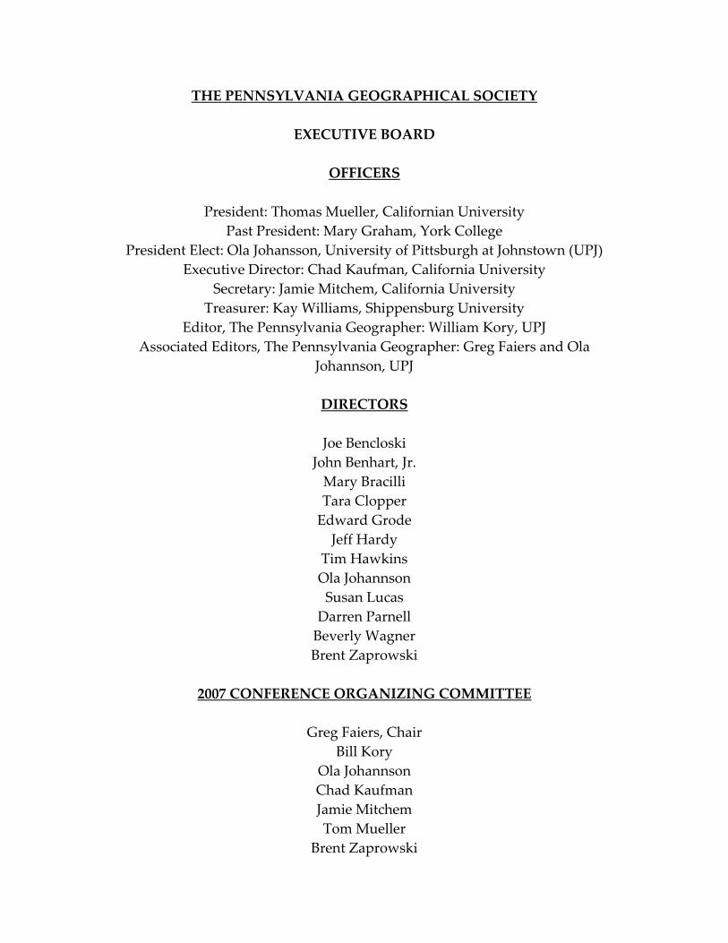
THE PENNSYLVANIA GEOGRAPHICAL SOCIETY
EXECUTIVE BOARD
OFFICERS
President: Thomas Mueller, Californian University Past President: Mary Graham, York College
President Elect: Ola Johansson, University of Pittsburgh at Johnstown (UPJ) Executive Director: Chad Kaufman, California University
Secretary: Jamie Mitchem, California University Treasurer: Kay Williams, Shippensburg University
Editor, The Pennsylvania Geographer: William Kory, UPJ Associated Editors, The Pennsylvania Geographer: Greg Faiers and Ola
Johannson, UPJ
DIRECTORS
Joe Bencloski John Benhart, Jr. Mary Bracilli Tara Clopper Edward Grode Jeff Hardy
Tim Hawkins Ola Johannson Susan Lucas Darren Parnell Beverly Wagner Brent Zaprowski
2007 CONFERENCE ORGANIZING COMMITTEE
Greg Faiers, Chair
Bill Kory Ola Johannson Chad Kaufman Jamie Mitchem Tom Mueller
Brent Zaprowski
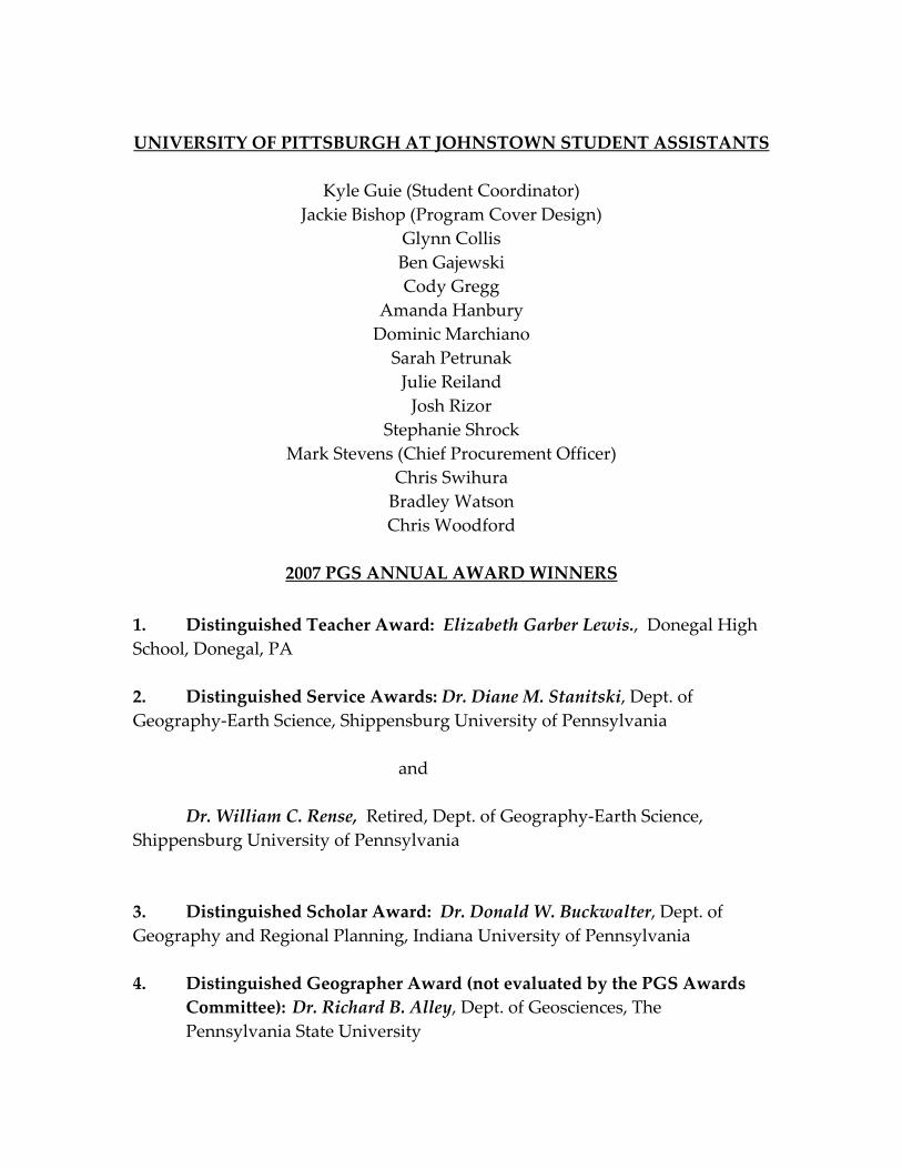
UNIVERSITY OF PITTSBURGH AT JOHNSTOWN STUDENT ASSISTANTS
Kyle Guie (Student Coordinator)
Jackie Bishop (Program Cover Design) Glynn Collis Ben Gajewski Cody Gregg
Amanda Hanbury Dominic Marchiano Sarah Petrunak Julie Reiland Josh Rizor
Stephanie Shrock Mark Stevens (Chief Procurement Officer)
Chris Swihura Bradley Watson Chris Woodford
2007 PGS ANNUAL AWARD WINNERS
1. Distinguished Teacher Award: Elizabeth Garber Lewis., Donegal High School, Donegal, PA 2. Distinguished Service Awards: Dr. Diane M. Stanitski, Dept. of Geography‐Earth Science, Shippensburg University of Pennsylvania
and Dr. William C. Rense, Retired, Dept. of Geography‐Earth Science,
Shippensburg University of Pennsylvania
3. Distinguished Scholar Award: Dr. Donald W. Buckwalter, Dept. of Geography and Regional Planning, Indiana University of Pennsylvania 4. Distinguished Geographer Award (not evaluated by the PGS Awards
Committee): Dr. Richard B. Alley, Dept. of Geosciences, The Pennsylvania State University

Holiday Inn Floor Plan
DIRECTIONS TO THE HERITAGE DISCOVERY CENTER (BANQUET SITE)
1. Take PA 56/403 west from downtown Johnstown. 2. Pass underneath the stone arch railroad bridge. 3. The road will curve to the left. 4. The Heritage Discovery Center will be on your left at the corner of 56/403
(Broad St.) and 6th Avenue.
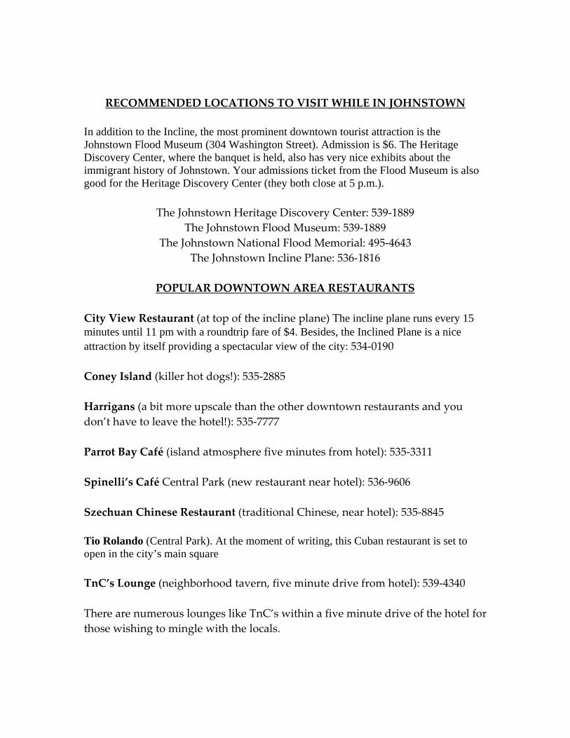
RECOMMENDED LOCATIONS TO VISIT WHILE IN JOHNSTOWN
In addition to the Incline, the most prominent downtown tourist attraction is the Johnstown Flood Museum (304 Washington Street). Admission is $6. The Heritage Discovery Center, where the banquet is held, also has very nice exhibits about the immigrant history of Johnstown. Your admissions ticket from the Flood Museum is also good for the Heritage Discovery Center (they both close at 5 p.m.).
The Johnstown Heritage Discovery Center: 539‐1889
The Johnstown Flood Museum: 539‐1889 The Johnstown National Flood Memorial: 495‐4643
The Johnstown Incline Plane: 536‐1816
POPULAR DOWNTOWN AREA RESTAURANTS
City View Restaurant (at top of the incline plane) The incline plane runs every 15 minutes until 11 pm with a roundtrip fare of $4. Besides, the Inclined Plane is a nice attraction by itself providing a spectacular view of the city: 534‐0190 Coney Island (killer hot dogs!): 535‐2885 Harrigans (a bit more upscale than the other downtown restaurants and you don’t have to leave the hotel!): 535‐7777 Parrot Bay Café (island atmosphere five minutes from hotel): 535‐3311 Spinelli’s Café Central Park (new restaurant near hotel): 536‐9606 Szechuan Chinese Restaurant (traditional Chinese, near hotel): 535‐8845 Tio Rolando (Central Park). At the moment of writing, this Cuban restaurant is set to open in the city’s main square TnC’s Lounge (neighborhood tavern, five minute drive from hotel): 539‐4340 There are numerous lounges like TnC’s within a five minute drive of the hotel for those wishing to mingle with the locals.
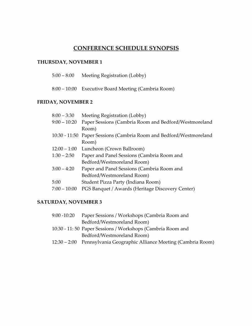
CONFERENCE SCHEDULE SYNOPSIS
THURSDAY, NOVEMBER 1 5:00 – 8:00 Meeting Registration (Lobby) 8:00 – 10:00 Executive Board Meeting (Cambria Room)
FRIDAY, NOVEMBER 2 8:00 – 3:30 Meeting Registration (Lobby)
9:00 – 10:20 Paper Sessions (Cambria Room and Bedford/Westmoreland Room)
10:30 ‐ 11:50 Paper Sessions (Cambria Room and Bedford/Westmoreland Room)
12:00 – 1:00 Luncheon (Crown Ballroom) 1:30 – 2:50 Paper and Panel Sessions (Cambria Room and
Bedford/Westmoreland Room) 3:00 – 4:20 Paper and Panel Sessions (Cambria Room and
Bedford/Westmoreland Room) 5:00 Student Pizza Party (Indiana Room) 7:00 – 10:00 PGS Banquet / Awards (Heritage Discovery Center)
SATURDAY, NOVEMBER 3
9:00 ‐10:20 Paper Sessions / Workshops (Cambria Room and Bedford/Westmoreland Room)
10:30 ‐ 11: 50 Paper Sessions / Workshops (Cambria Room and Bedford/Westmoreland Room)
12:30 – 2:00 Pennsylvania Geographic Alliance Meeting (Cambria Room)
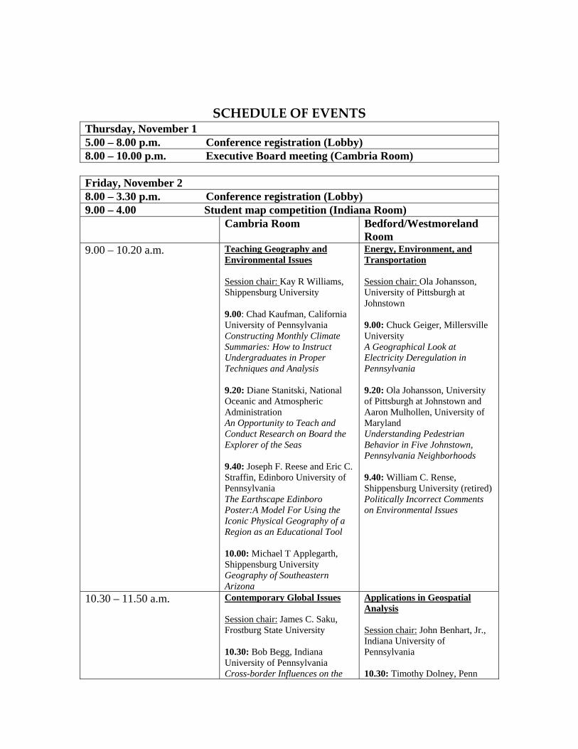
SCHEDULE OF EVENTS Thursday, November 1 5.00 – 8.00 p.m. Conference registration (Lobby) 8.00 – 10.00 p.m. Executive Board meeting (Cambria Room) Friday, November 2 8.00 – 3.30 p.m. Conference registration (Lobby) 9.00 – 4.00 Student map competition (Indiana Room) Cambria Room Bedford/Westmoreland
Room 9.00 – 10.20 a.m. Teaching Geography and
Environmental Issues Session chair: Kay R Williams, Shippensburg University 9.00: Chad Kaufman, California University of Pennsylvania Constructing Monthly Climate Summaries: How to Instruct Undergraduates in Proper Techniques and Analysis 9.20: Diane Stanitski, National Oceanic and Atmospheric Administration An Opportunity to Teach and Conduct Research on Board the Explorer of the Seas 9.40: Joseph F. Reese and Eric C. Straffin, Edinboro University of Pennsylvania The Earthscape Edinboro Poster:A Model For Using the Iconic Physical Geography of a Region as an Educational Tool 10.00: Michael T Applegarth, Shippensburg University Geography of Southeastern Arizona
Energy, Environment, and Transportation Session chair: Ola Johansson, University of Pittsburgh at Johnstown 9.00: Chuck Geiger, Millersville University A Geographical Look at Electricity Deregulation in Pennsylvania 9.20: Ola Johansson, University of Pittsburgh at Johnstown and Aaron Mulhollen, University of Maryland Understanding Pedestrian Behavior in Five Johnstown, Pennsylvania Neighborhoods 9.40: William C. Rense, Shippensburg University (retired) Politically Incorrect Comments on Environmental Issues
10.30 – 11.50 a.m. Contemporary Global Issues Session chair: James C. Saku, Frostburg State University 10.30: Bob Begg, Indiana University of Pennsylvania Cross-border Influences on the
Applications in Geospatial Analysis Session chair: John Benhart, Jr., Indiana University of Pennsylvania 10.30: Timothy Dolney, Penn

Configuration of the Bulgarian Apparel Industry 10.50: John E Benhart Sr. and George Pomeroy, Shippensburg University Landscapes of South Korea 11.10: James C. Saku, Frostburg State University Ethnic Conflict in Sub-Saharan Africa: Is There an End in Sight? 11.30: Donald W. Buckwalter, Indiana University of Pennsylvania Moscow under Communism 1921-1941: The Significance of Some Landscape Artifacts
State Altoona The VERTUS Model - Vehicle Emissions Related to Urban Sprawl 10.50: John Benhart, Jr., Indiana University of Pennsylvania Large-Format Mine Maps and Their Importance in Pennsylvania: Geospatial Data Development at the IUP Institute for Mine Mapping, Archival Procedures and Safety (IMAPS) 11.30: Jamie Mitchem and Tom Mueller, California University of Pennsylvania Spatial Analysis of Social Vulnerability in Southwestern Pennsylvania
12.00 – 1.00 p.m. Luncheon (Crown Ballroom) 1.00 – 1.30 p.m. PGS Annual Business Meeting Cambria Room Bedford/Westmoreland
Room 1.30 – 2.50 History, People and Landscape
Session chair: William Kory, University of Pittsburgh at Johnstown 1.30: Mary M. Graham, York College of Pennsylvania and Richard D. Stone, Shippensburg University The Vicksburg Campaign: Upholding the Myth of the Lost Cause via Selective Battlefield Preservation. 1.50: Paul D. McDermott, Montgomery College and Phillip Mobley, George Mason University Conococheague Manor: A View of Early Settlement and Vernacular Architecture in the Backcountry 2.10: Karen M. Trifonoff, Bloomsburg University Pennsylvania Population: Old People and Old Houses 2.30: William Kory, University
Student Paper Competition Session chair: Ola Johansson, University of Pittsburgh at Johnstown 1.30: Stephanie M Hill, Salisbury University A Study of Rainfall-Triggered Landslides on a Global Scale 1.50: Rui Li, The Pennsylvania State University The Role of Landmarks on Human Environmental Knowledge and Cognitive Map Development 2.10: Brent W. Moats, The Pennsylvania State University Assessment of Remote Sensing Techniques in Detecting Surface Water in Landsat Images 2.30: Erin E. Pierce, The Pennsylvania State University Evaluation of Digital Globe Programs For K-12 Educational Purposes
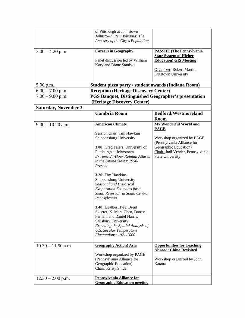
of Pittsburgh at Johnstown Johnstown, Pennsylvania: The Ancestry of the City’s Population
3.00 – 4.20 p.m. Careers in Geography Panel discussion led by William Kory and Diane Staniski
PASSHE (The Pennsylvania State System of Higher Education) GIS Meeting Organizer: Robert Martin, Kutztown University
5.00 p.m. Student pizza party / student awards (Indiana Room) 6.00 – 7.00 p.m. Reception (Heritage Discovery Center) 7.00 – 9.00 p.m. PGS Banquet, Distinguished Geographer’s presentation
(Heritage Discovery Center) Saturday, November 3 Cambria Room Bedford/Westmoreland
Room 9.00 – 10.20 a.m. American Climate
Session chair: Tim Hawkins, Shippensburg University 3.00: Greg Faiers, University of Pittsburgh at Johnstown Extreme 24-Hour Rainfall Atlases in the United States: 1950-Present 3.20: Tim Hawkins, Shippensburg University Seasonal and Historical Evaporation Estimates for a Small Reservoir in South Central Pennsylvania 3.40: Heather Hyre, Brent Skeeter, X. Mara Chen, Darren Parnell, and Daniel Harris, Salisbury University Extending the Spatial Analysis of U.S. Secular Temperature Fluctuations: 1971-2000
My Wonderful World and PAGE Workshop organized by PAGE (Pennsylvania Alliance for Geographic Education) Chair: Jodi Vender, Pennsylvania State University
10.30 – 11.50 a.m. Geography Action! Asia Workshop organized by PAGE (Pennsylvania Alliance for Geographic Education) Chair: Kristy Snider
Opportunities for Teaching Abroad: China Revisited Workshop organized by John Katana
12.30 – 2.00 p.m. Pennsylvania Alliance for Geographic Education meeting
ABSTRACTS
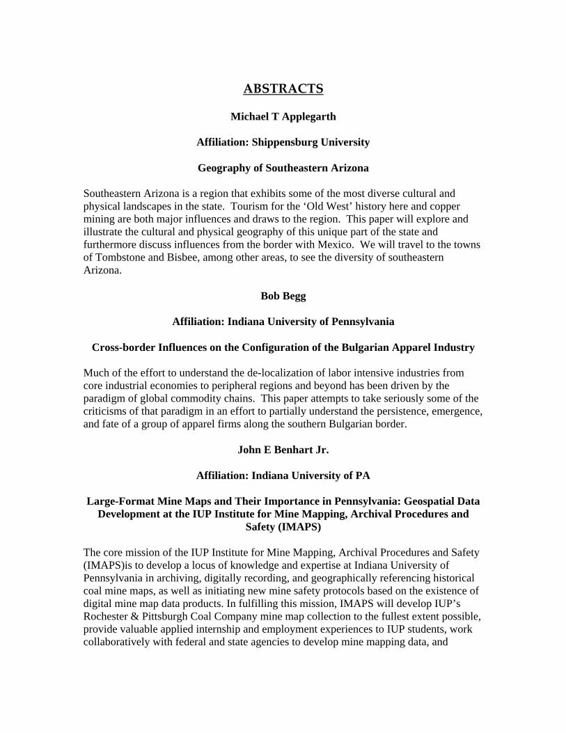
Michael T Applegarth
Affiliation: Shippensburg University
Geography of Southeastern Arizona Southeastern Arizona is a region that exhibits some of the most diverse cultural and physical landscapes in the state. Tourism for the ‘Old West’ history here and copper mining are both major influences and draws to the region. This paper will explore and illustrate the cultural and physical geography of this unique part of the state and furthermore discuss influences from the border with Mexico. We will travel to the towns of Tombstone and Bisbee, among other areas, to see the diversity of southeastern Arizona.
Bob Begg
Affiliation: Indiana University of Pennsylvania
Cross-border Influences on the Configuration of the Bulgarian Apparel Industry Much of the effort to understand the de-localization of labor intensive industries from core industrial economies to peripheral regions and beyond has been driven by the paradigm of global commodity chains. This paper attempts to take seriously some of the criticisms of that paradigm in an effort to partially understand the persistence, emergence, and fate of a group of apparel firms along the southern Bulgarian border.
John E Benhart Jr.
Affiliation: Indiana University of PA
Large-Format Mine Maps and Their Importance in Pennsylvania: Geospatial Data Development at the IUP Institute for Mine Mapping, Archival Procedures and
Safety (IMAPS)
The core mission of the IUP Institute for Mine Mapping, Archival Procedures and Safety (IMAPS)is to develop a locus of knowledge and expertise at Indiana University of Pennsylvania in archiving, digitally recording, and geographically referencing historical coal mine maps, as well as initiating new mine safety protocols based on the existence of digital mine map data products. In fulfilling this mission, IMAPS will develop IUP’s Rochester & Pittsburgh Coal Company mine map collection to the fullest extent possible, provide valuable applied internship and employment experiences to IUP students, work collaboratively with federal and state agencies to develop mine mapping data, and
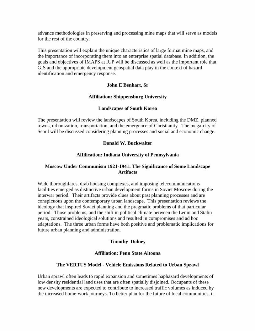
advance methodologies in preserving and processing mine maps that will serve as models for the rest of the country. This presentation will explain the unique characteristics of large format mine maps, and the importance of incorporating them into an enterprise spatial database. In addition, the goals and objectives of IMAPS at IUP will be discussed as well as the important role that GIS and the appropriate development geospatial data play in the context of hazard identification and emergency response.
John E Benhart, Sr
Affiliation: Shippensburg University
Landscapes of South Korea
The presentation will review the landscapes of South Korea, including the DMZ, planned towns, urbanization, transportation, and the emergence of Christianity. The mega-city of Seoul will be discussed considering planning processes and social and economic change.
Donald W. Buckwalter
Affilication: Indiana University of Pennsylvania
Moscow Under Communism 1921-1941: The Significance of Some Landscape Artifacts
Wide thoroughfares, drab housing complexes, and imposing telecommunications facilities emerged as distinctive urban development forms in Soviet Moscow during the interwar period. Their artifacts provide clues about past planning processes and are conspicuous upon the contemporary urban landscape. This presentation reviews the ideology that inspired Soviet planning and the pragmatic problems of that particular period. Those problems, and the shift in political climate between the Lenin and Stalin years, constrained ideological solutions and resulted in compromises and ad hoc adaptations. The three urban forms have both positive and problematic implications for future urban planning and administration.
Timothy Dolney
Affiliation: Penn State Altoona
The VERTUS Model - Vehicle Emissions Related to Urban Sprawl
Urban sprawl often leads to rapid expansion and sometimes haphazard developments of low density residential land uses that are often spatially disjoined. Occupants of these new developments are expected to contribute to increased traffic volumes as induced by the increased home-work journeys. To better plan for the future of local communities, it
is necessary to pay attention to the locations of such developments. Since changes of land use patterns and residential developments are long term processes and, in almost all cases, irreversible, modeling their future trends with computer simulations is one of few feasible approaches to better understand how they evolve and to better plan for their future courses.
This research discusses the design philosophy and implementation of the VERTUS (Vehicle Emissions Related to Urban Sprawl) model. This operational model was constructed using Visual Basics programming langue to perform high level customization of GIS (Geographic Information System) software. The model is specific towards estimating the amount of home-work journeys generated by a given level and area of urban sprawl. Consideration was given to examining ways in which different geographic variations may affect the outcomes of resulting home-work journeys. This model has been developed to assess how the number of home-work journeys impacts the environment in terms of vehicle emissions using projected housing increases for Geauga County, Ohio as a case study.
Greg Faiers
Affiliation: University of Pittsburgh at Johnstown
Extreme 24-Hour Rainfall Atlases in the United States: 1950-Present
Civil Engineers, water resource planners, agricultural scientists and many more have professional interests in obtaining reliable extreme rainfall probabilities. The Hydrology branch of the National Weather Service published a nation-wide atlas in the late 1950’s and this office and some of the Regional Climate Centers, have sought to update this information for the general public over the past 15 years. This presentation is an overview of these reports, the methodology entailed and some of the problems encountered in the preparation of these atlases.
Chuck Geiger
Affiliation: Millersville University
A Geographical Look at Electricity Deregulation in Pennsylvania
The process of electricity deregulation in Pennsylvania, begun in 1996, is scheduled for its “commencement” beginning around 2010. This report summarizes the current status of the transition and compares the perceptions of the different participants in the venture. Both praise and doubts abound, and vary regionally as well as across the sectors of the state’s economy.
Mary M. Graham
Affiliation: York College of Pennsylvania
And
Richard Stone
Affiliation: Shippensburg University
The Vicksburg Campaign: Upholding the Myth of the Lost Cause via Selective Battlefield Preservation.
Vicksburg, located high on the bluff above the Mississippi River was one of two of the last places on the river held by the Confederates in 1863. It provided a citadel that they perceived could not be captured by Union forces. After several failed attempts to take Vicksburg from the North, General Grant devised an alternative plan by which his troops attacked from the East via the back door. The authors examined the preservation of the various battlefields of the campaign taking into consideration the tenets of the Southern "Lost Cause." Differences in amount of preservation were ascertained with respect to whether the battlefield was preserved through federal state, or local efforts.
Tim Hawkins
Affiliation: Shippensburg University
Seasonal and Historical Evaporation Estimates for a Small Reservoir in South Central Pennsylvania
Evaporation estimates were made for a small municipal water supply reservoir in south central Pennsylvania using two common methods for estimating evaporation: the bulk profile and Thornthwaite methods. Data, including air temperature, water surface temperature, wind speed, and relative humidity, were collected from a meteorological buoy from May 17 to Oct 20, 2006. Thornthwaite evaporation estimates were generally higher during warm periods while bulk profile estimates were larger during cooler periods. However, over the five-month period estimates differed by 9.1%. Using historical meteorological data and the Thornthwaite method, 23.9 m of water (683 mm/yr) were estimated to have evaporated from the reservoir over its life. Estimated evaporation has been increasing in conjunction with known climate changes in the region.
Stephanie M. Hill
Affiliation: Salisbury University (Student)
A Study of Rainfall-Triggered Landslides on a Global Scale
Landslides, on a global scale, kill thousands of people and cause billions of dollars in property damage each year. Hong, Adler, and Huffman developed an algorithm that took into consideration the susceptibility of a landslide location based on topography, soil properties, and land cover, etc. and the Rainfall Intensity-Duration equation to detect possible landslide locations with regard to heavy rainfall. Actual global landslide locations from 2003 were then compared with algorithm predicted events and plotted into ArcMap to get a sense of how valid the algorithm actually was. The algorithm over predicted for the western coast of India and under predicted for the mountainous areas of northern India and central China. Further work will be completed to investigate if the satellites that were used have limitations with picking up orographic rainfall over these mountainous regions.
Heather Hyre, Brent Skeeter, X. Mara Chen, Darren Parnell, and Daniel Harris
Affiliation: Salisbury University
Extending the Spatial Analysis of U.S. Secular Temperature Fluctuations: 1971-2000
A previous study (Lawson et al. 1981) identified nine regions of distinct temperature trends across the U.S. based on the data from 1912-1971 for 27 benchmark stations. The purpose of this study is to use the same methodology to: (1) extend the analysis of temperature fluctuations from 1971-2000, (2) generate temperature trend clusters and compare them with the previous nine regions, and (3) suggest possible explanations for the differences between the clusters of the two study periods. The results of the current study indicate fourteen regions with distinct temperature trends. The differences in temperature trend clusters from the previous study indicate a lack of consistent temperature trend patterns.
Ola Johansson
Affiliation: University of Pittsburgh at Johnstown
and
Aaron Mulhollen
Affiliation: University of Maryland
Understanding Pedestrian Behavior in Five Johnstown, Pennsylvania Neighborhoods
In contemporary urban planning, alternatives to automobile use are considered beneficial, including enhanced urban livability, the promotion of good health and well-being of the population, and higher levels of sustainability. We have investigated the level of pedestrianism in five Johnstown, Pennsylvania neighborhoods with different physical and socio-economic characteristics. The primary method of data gathering was to conduct “headcounts” – recording the number of pedestrians through direct observation. At discrete time periods, observation teams conducted simultaneous pedestrian counts at the study sites. Data from the Census was subsequently used to correlate socio-economic characteristics with neighborhood pedestrian behavior. Previous studies of pedestrianism has used aggregate survey data; however, the headcount approach also allows for the comparison of individual, qualitative neighborhoods characteristics that can augment planners’ understanding of what factors affect pedestrian behavior.
Chad Kaufman
Affiliation: California University of Pennsylvania
Constructing Monthly Climate Summaries: How to Instruct Undergraduates in Proper Techniques & Analysis
The typical undergraduate student in the Atmospheric Sciences focuses on the present and prognosticates into the future. However, much can be learned by looking in the opposite direction --the past. From weather station data collected on from the Southwestern Pennsylvania region, students have been instructed which resources and analysis techniques are most effective in describing the climatic character of the past thirty days. Students are taught which elements of the analysis are appropriate in the summarization and how best to convey the important synoptic elements to the reader.
Technical writing styles are emphasized during the review process. Examples and resources will be shared during the discussion.
William B. Kory
Affiliation: University of Pittsburgh at Johnstown
Johnstown, Pennsylvania: The Ancestry of the City’s Population. “What is this person’s ancestry or ethnic origin ?” This was one of the questions listed on the long form of the 2000 US Census of Population. Of the nearly 24,000 people counted as residents in the city of Johnstown, a great majority answered the question related to their ancestry. The number, in fact, was higher than the total population, because many people reported multiple ancestries. This presentation will focus on the size and composition of ethnic population in the city of Johnstown. The groups will be ranked and compared to the largest groups which resided in the city thirty years ago. At that time, a survey was conducted to determine the ethnic composition of the city’s residents. The spatial distribution of the largest ethnic groups will be examined to determine the general location and “clusters” of various ethnic groups.
Rui Li (Student)
Affiliation: The Pennsylvania University at University Park
The role of landmarks on human environmental knowledge and cognitive map development
Finding our way out in a place is so ordinary which happens in almost everyday of our lives. However, understanding how we perceive and make use of the information of a familiar environment, which contributes to the application of navigational aids and emergency, holds high regards. Especially the order of a person developing the three levels of environmental knowledge: landmark-, route- and survey-based knowledge is still being debated in different frameworks. Experiments was conducted to review different frameworks in this paper and to understand the different scenarios of environment contributing to the development of environmental knowledge and cognitive map.
Paul D. McDermott, Professor Emeritus and Phillip Mobley
Affiliation: George Mason University
Conococheague Manor: A View of Early Settlement and Vernacular Architecture in the Backcountry
Conococheague Manor was the most westerly of the proprietary holdings of Lord Baltimore, Frederick Calvert, early colonial ruler of Maryland. Created in 1734, the manor was situated along the banks of the Potomac River in that part of the colony that was later to become Washington County (south of present-day Williamsport and about eight miles southwest of Hagerstown). The original survey of the manor included 10,581 acres, which made it an extremely large land holding.[i] The manor was one of two large proprietary holdings created in the backcountry to generate revenue for Lord Baltimore. The other holding, Monocacy, was established to the east of the Blue Ridge Mountains near Frederick, Maryland. When Conococheague and other manors failed to generate the anticipated revenue expected by Lord Baltimore, he divested himself of these holdings in the late 1760s. Fortunately for researchers, when Lord Baltimore divested himself of these holdings, a complete inventory of what was on the land was made in 1767. The quality of the inventories varied; no map survives showing the locations of the individual holdings; and much information has been lost with the passage of time. Still, the 1767 inventory and other records offer insight into certain aspects of colonial life, including patterns of tenancy and settlement, building construction, and land use.
Jamie Mitchem
Affiliation: California University of Pennsylvania
Spatial Analysis of Social Vulnerability in Southwestern Pennsylvania
Social vulnerability refers to a community’s ability to cope with environmental hazards, and it is influenced by the demographics and socioeconomic conditions in the area. This study analyzed U.S. Census data at the Census tract scale to investigate regional variations in social vulnerability in Greene, Fayette, Washington, and Westmoreland counties in southwestern Pennsylvania using principal components analysis and GIS software. The results of the study were superimposed with various hazards data (e.g. 100 year flood plain) to investigate spatial variations in overall place vulnerability. Specific indicators that impact social vulnerability in the region were analyzed to propose ways of reducing social vulnerability most effectively in an effort to hopefully reduce disaster losses in southwestern Pennsylvania.
Brent W Moats (Student)
Affiliation: Pennsylvania State University
Assessment of Remote Sensing Techniques in Detecting Surface Water
in Landsat Images
With changing climate conditions water resources are being increasingly important to Western Society. Availability of water has always been important in developing countries and will continue to be so as population growth and drought further stretch already critical resources. Remote sensing offers techniques to observe water levels and any changes that may occur. Remote sensing also includes the benefits of non-disturbance to the area observed and lower cost when compared to conducting a full field study. Numerous remote sensing techniques have been developed to detect surface water. This study will assess the accuracy of employing these techniques.
Tom Mueller
Affiliation: California University of Pennsylvania
Spatial Analysis of Social Vulnerability in Southwestern Pennsylvania
Social vulnerability refers to a community’s ability to cope with environmental hazards, and it is influenced by the demographics and socioeconomic conditions in the area. This study analyzed U.S. Census data at the Census tract scale to investigate regional variations in social vulnerability in Greene, Fayette, Washington, and Westmoreland counties in southwestern Pennsylvania using principal components analysis and GIS software. The results of the study were superimposed with various hazards data (e.g. 100 year flood plain) to investigate spatial variations in overall place vulnerability. Specific indicators that impact social vulnerability in the region were analyzed to propose ways of reducing social vulnerability most effectively in an effort to hopefully reduce disaster losses in southwestern Pennsylvania.
Erin E Pierce (Student)
Affiliation: Pennsylvania State University
Evaluation of Digital Globe Programs For K-12 Educational Purposes
The advent of accessible digital globe technology may be a useful weapon for the attack on geographic illiteracy, but teachers must first decide which program will best suit their educational environments before choosing one to implement in their classroom. The purpose of this project is to help educators identify whether Google Earth or NASA's
World Wind is the best program for their curriculum. The programs will be evaluated with respect to selected attributes deemed critical for educators: overall cost, ease of use, compatibility with educational goals, data availability and quality, as well as established support and user-community.
Joseph F Reese and Eric C. Straffin
Affiliation: Edinboro University of Pennsylvania
The Earthscape Edinboro Poster: A model for using the iconic physical geography of a region as an educational tool
Northwestern Pennsylvania is characterized by physical geographic features and phenomena that uniquely define its “earthscape”. We’ve created an educational poster that focuses on the identifying icons of Edinboro’s earthscape. These aspects include the Lake Erie shoreline, especially Presque Isle, lake-effect snow, French Creek watershed, local bedrock, especially related to petroleum, viticulture, and glacial landforms. These facets greatly impact the local landscape, economy, culture, tourism, and history. For Earth Science Week 2007, we’ve sent the poster to schools in northwestern Pennsylvania for their use. Importantly, every region has its own earthscape – one that’s useful as an effective educational tool.
William C Rense
Affiliation: Shippensburg University, Retired
Politically Incorrect Comments on Environmental Issues
Three important issues facing society today are (1) global warming (climate change), (2) energy and (3) urban sprawl. This paper provides comments – some politically incorrect – about these issues. Global warming and energy are closely related subjects. This paper looks specifically at the role of coal, nuclear power, renewable energy sources and ethanol while also questioning popular ideas about energy futures. The paper suggests that global warming is occurring but questions the magnitude of warming as well as the resulting severity of social, economic and environmental impacts. The paper also questions the critics of urban sprawl.
James C Saku
Affiliation: Frostburg State University
Ethnic conflict in Sub-Saharan Africa: Is there an end in sight?
Ethnic conflict is an endemic problem confronting sub-Saharan Africans. While historic factors such as colonial policies may account for ethnic division and conflict, the present geo-political landscape is also responsible for the conflict. The effect of ethnic conflict on
the economic and social lives of sub-Saharan Africans is significant. For example, national economies of countries like the Ivory Coast, Sierra Leone, Liberia and Rwanda have deteriorated over the years because of ethnic conflict. Without ethnic harmony, economic growth and prosperity will continue to deteriorate in sub-Saharan Africa. This paper discusses the factors that are responsible for ethnic conflict in sub-Saharan Africa. The impacts of ethnic conflict are examined and solutions to these problems are offered.
Diane Stanitiski
Affiliation: NOAA, Boulder, CO
An Opportunity to Teach and Conduct Research on Board the Explorer of the Seas
Royal Caribbean Cruise Lines has incorporated state-of-the-art technology on their ship, Explorer of the Seas, by adding ocean and atmospheric science laboratories to increase the public’s awareness and understanding of ocean science. Equipped with high-tech facilities, the Explorer helps scientists discover answers to some of today’s most significant questions in ocean and climate research. Ongoing, continuous observations along cruise tracks provide improved descriptions of seasonal to interannual variability in the ocean and atmosphere within the tropics. Opportunities exist for educators to develop and test new measurement methods and devices, conduct personal research, and lecture on board.
Karen M. Trifonoff
Affiliation: Bloomsburg University
Pennsylvania Population: Old People and Old Houses
Over the past 25 years, Pennsylvania has been characterized as a state with high rural and elderly populations. While true, stopping with these generalizations can cause us to overlook the more subtle population dynamics at work across the Commonwealth. This county level analysis looks at the rural and elderly nature of Pennsylvania population, and compares and contrasts these factors against other variables, such as income, education elderly home owners, and median house values. The paper focuses on quantitative analyses and map displays; a cartographic cross-classification is used to help visualize the data.
Kay R Williams
Affiliation: Shippensburg University
Teaching Conservation Effectively
It has become increasingly evident that Americans need to be much more aware of the true state of the environment and the roles humans play within it. Without exposure to
knowledge about Earth, we cannot be stewards of it. The majority of students today are growing up in a time of media frenzy, giving them the perception that it is necessary for information to be delivered to them in a variety of formats. Teaching conservation can incorporate an assortment of experiences that can be effective in enlightening students to their interconnections with nature and how they can become involved in its preservation. This poster illustrates a variety of techniques that have been utilized over the years to increase student participation in their learning experience and interest in the environment. These attempts have been well received, and according to evaluations of various kinds, seem to be effective in achieving these goals.
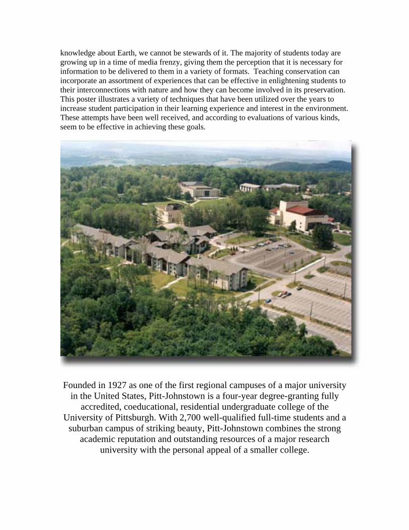
Founded in 1927 as one of the first regional campuses of a major university in the United States, Pitt-Johnstown is a four-year degree-granting fully
accredited, coeducational, residential undergraduate college of the University of Pittsburgh. With 2,700 well-qualified full-time students and a
suburban campus of striking beauty, Pitt-Johnstown combines the strong academic reputation and outstanding resources of a major research
university with the personal appeal of a smaller college.
REGISTRANTS (as of October 25, 2007)
Alexis Aguilar Judith Aker
Michael T. Applegarth Bob Begg
Toni Belskey Joe Bencloski
John Benhart, Jr John Benhart, Sr William Brady
Don Buckwalter Mara Chen
Glynn Collis Gary Coutu
Miriam Daisley Tim Dolney Greg Faiers
Chuck Geiger Mary Graham
Kyle Guie Tim Hawkins Stephanie Hill Heather Hyre Ola Johansson John Katana L. Kleitches
Bill Kory Kristen Kosaber
Mary Lavine Elizabeth Lewis
Mara Chen
Robert N. Martin Ron McCall
Paul D. McDermott Jamie Mitchem Brent W. Moats
Philip M. Mobley Tom Mueller
B. Okey George M. Palmeroy
Darren Parnell Erin Pierce
Cheryl Ploucha Matthew Puz, Jr. Rachel M. Ralls
J. F. Reese Rebecca Reinbold William C. Rense
James C. Saku Ruth Shirey
Bill Simmons Richard D. Stone
Connie Strittmatter Cal Thomas
Karen Trifonoff Jodi Vender
Kay Williams Nicholas Wise
Brent Zaprowski Robin Zavada
S. Zeglin
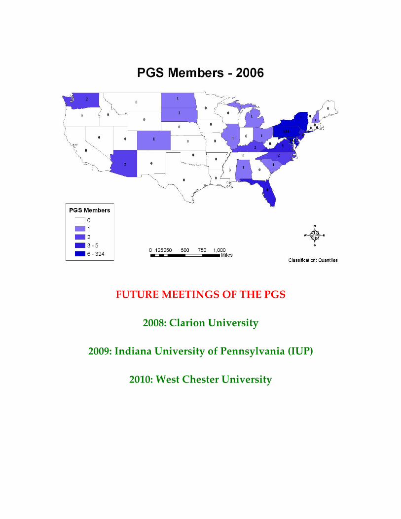
FUTURE MEETINGS OF THE PGS
2008: Clarion University
2009: Indiana University of Pennsylvania (IUP)
2010: West Chester University