Embed Size (px)
Citation preview
JULY 2019
WELCOME TO THE BALLARD BRIDGE PLANNING STUDY
DROP-IN SESSION
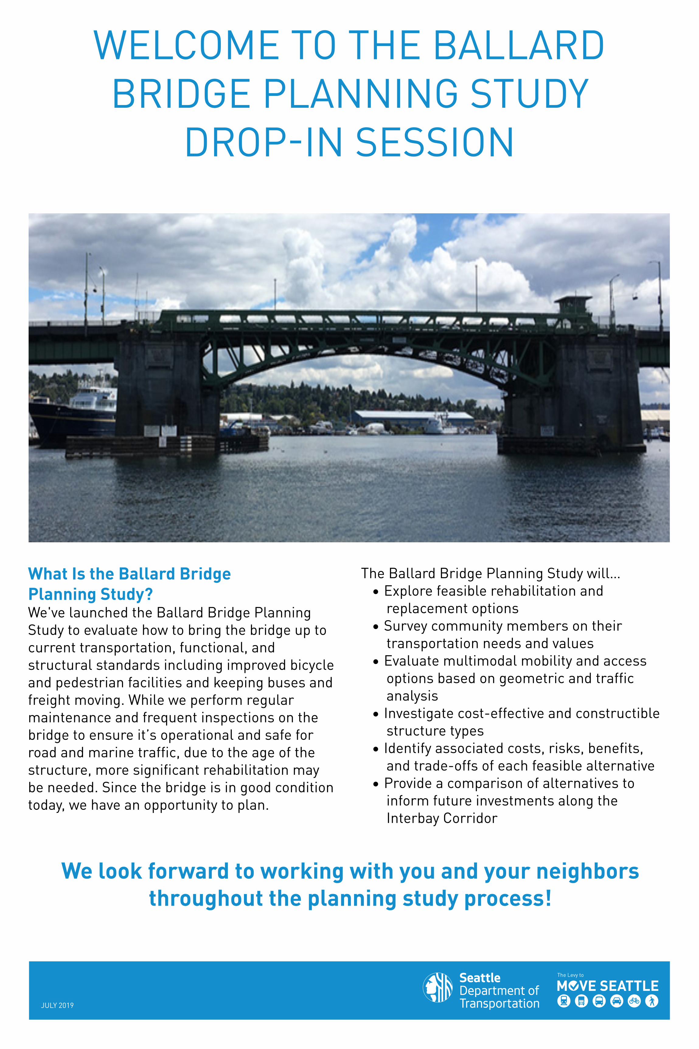
What Is the Ballard Bridge Planning Study?We've launched the Ballard Bridge Planning Study to evaluate how to bring the bridge up to current transportation, functional, and structural standards including improved bicycle and pedestrian facilities and keeping buses and freight moving. While we perform regular maintenance and frequent inspections on the bridge to ensure it’s operational and safe for road and marine traffic, due to the age of the structure, more significant rehabilitation may be needed. Since the bridge is in good condition today, we have an opportunity to plan.
We look forward to working with you and your neighbors throughout the planning study process!
The Ballard Bridge Planning Study will…• Explore feasible rehabilitation and
replacement options• Survey community members on their
transportation needs and values• Evaluate multimodal mobility and access
options based on geometric and traffic analysis
• Investigate cost-effective and constructible structure types
• Identify associated costs, risks, benefits, and trade-offs of each feasible alternative
• Provide a comparison of alternatives to inform future investments along the Interbay Corridor
JULY 2019
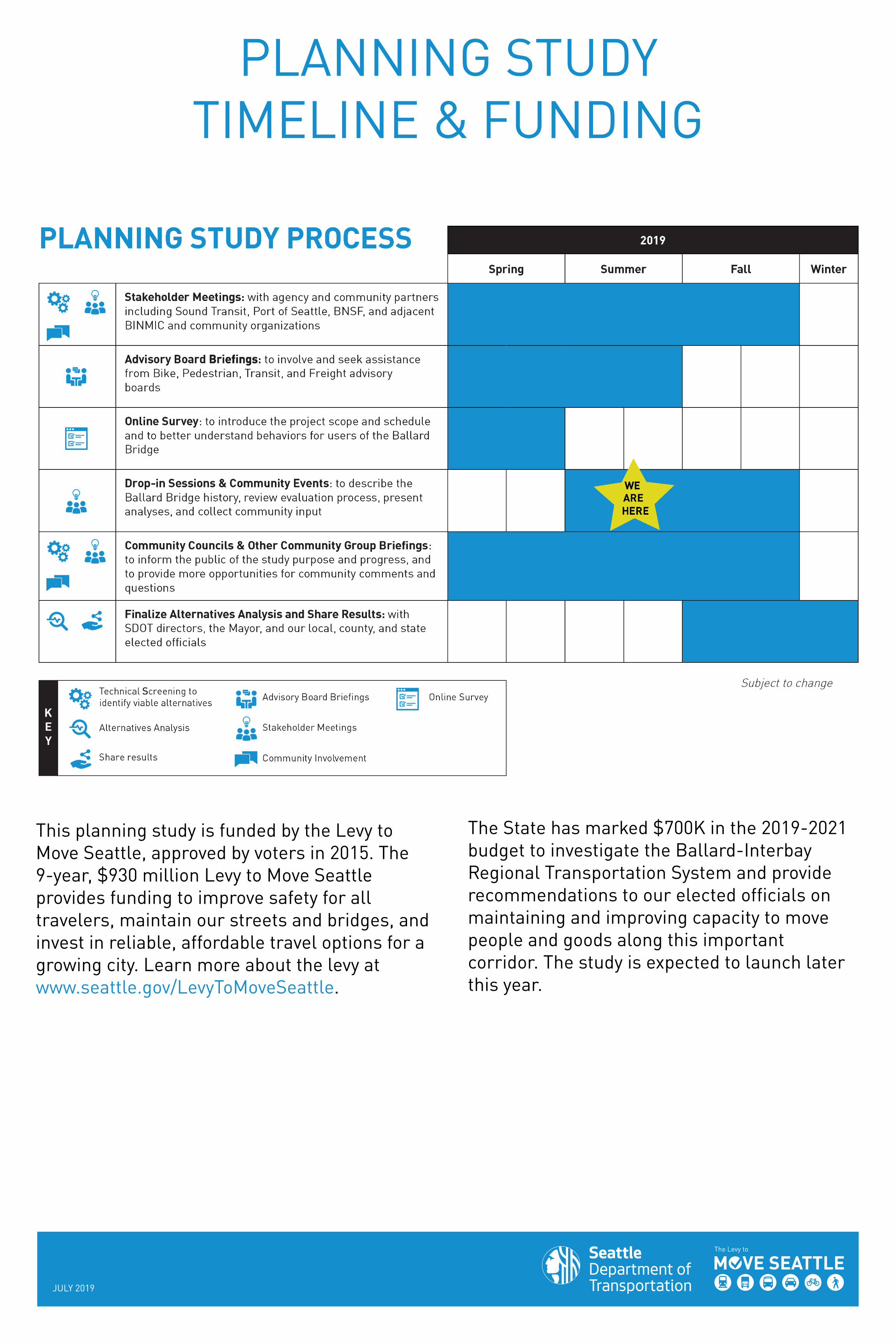
PLANNING STUDY TIMELINE & FUNDING
This planning study is funded by the Levy to Move Seattle, approved by voters in 2015. The 9-year, $930 million Levy to Move Seattle provides funding to improve safety for all travelers, maintain our streets and bridges, and invest in reliable, affordable travel options for a growing city. Learn more about the levy at www.seattle.gov/LevyToMoveSeattle.
The State has marked $700K in the 2019-2021 budget to investigate the Ballard-Interbay Regional Transportation System and provide recommendations to our elected officials on maintaining and improving capacity to move people and goods along this important corridor. The study is expected to launch later this year.
JULY 2019
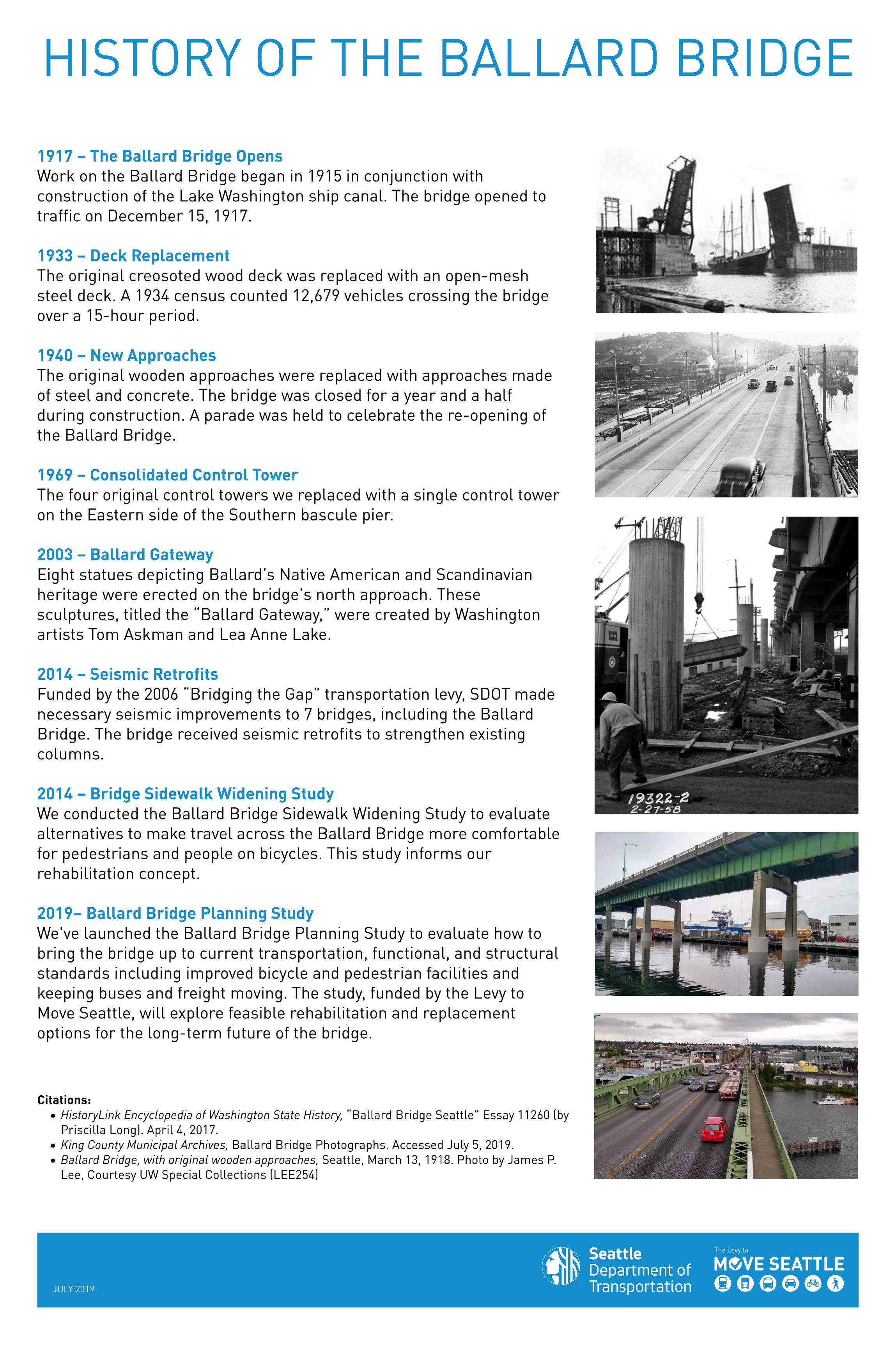
HISTORY OF THE BALLARD BRIDGE1917 – The Ballard Bridge OpensWork on the Ballard Bridge began in 1915 in conjunction with construction of the Lake Washington ship canal. The bridge opened to traffic on December 15, 1917.
1933 – Deck ReplacementThe original creosoted wood deck was replaced with an open-mesh steel deck. A 1934 census counted 12,679 vehicles crossing the bridge over a 15-hour period.
1940 – New ApproachesThe original wooden approaches were replaced with approaches made of steel and concrete. The bridge was closed for a year and a half during construction. A parade was held to celebrate the re-opening of the Ballard Bridge.
1969 – Consolidated Control TowerThe four original control towers we replaced with a single control tower on the Eastern side of the Southern bascule pier.
2003 – Ballard GatewayEight statues depicting Ballard’s Native American and Scandinavian heritage were erected on the bridge's north approach. These sculptures, titled the “Ballard Gateway,” were created by Washington artists Tom Askman and Lea Anne Lake.
2014 – Seismic RetrofitsFunded by the 2006 “Bridging the Gap” transportation levy, SDOT made necessary seismic improvements to 7 bridges, including the Ballard Bridge. The bridge received seismic retrofits to strengthen existing columns.
2014 – Bridge Sidewalk Widening StudyWe conducted the Ballard Bridge Sidewalk Widening Study to evaluate alternatives to make travel across the Ballard Bridge more comfortable for pedestrians and people on bicycles. This study informs our rehabilitation concept.
2019– Ballard Bridge Planning StudyWe've launched the Ballard Bridge Planning Study to evaluate how to bring the bridge up to current transportation, functional, and structural standards including improved bicycle and pedestrian facilities and keeping buses and freight moving. The study, funded by the Levy to Move Seattle, will explore feasible rehabilitation and replacement options for the long-term future of the bridge.
Citations:• HistoryLink Encyclopedia of Washington State History, “Ballard Bridge Seattle” Essay 11260 (by
Priscilla Long). April 4, 2017.• King County Municipal Archives, Ballard Bridge Photographs. Accessed July 5, 2019.• Ballard Bridge, with original wooden approaches, Seattle, March 13, 1918. Photo by James P.
Lee, Courtesy UW Special Collections (LEE254)
JULY 2019
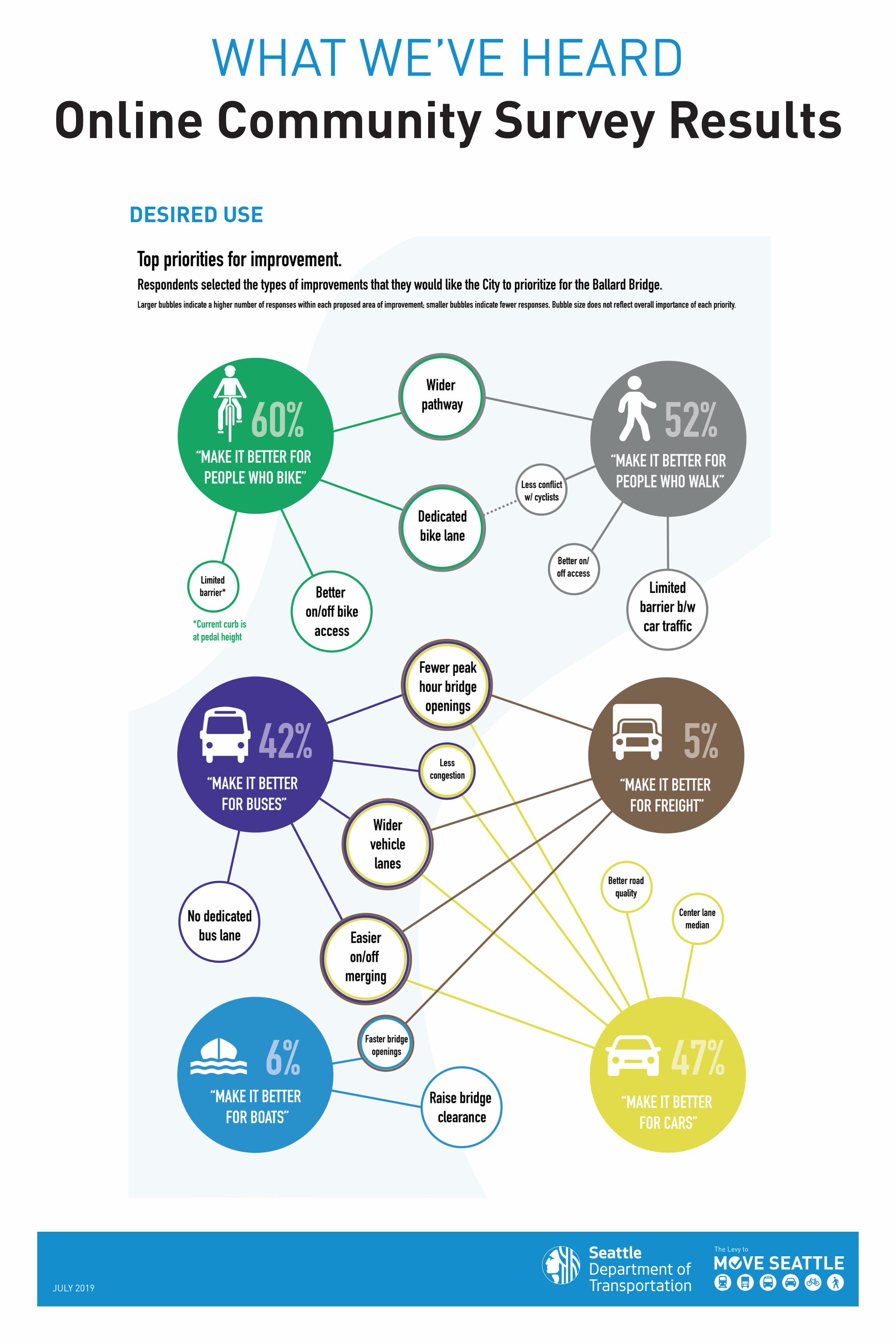
WHAT WE’VE HEARDOnline Community Survey Results
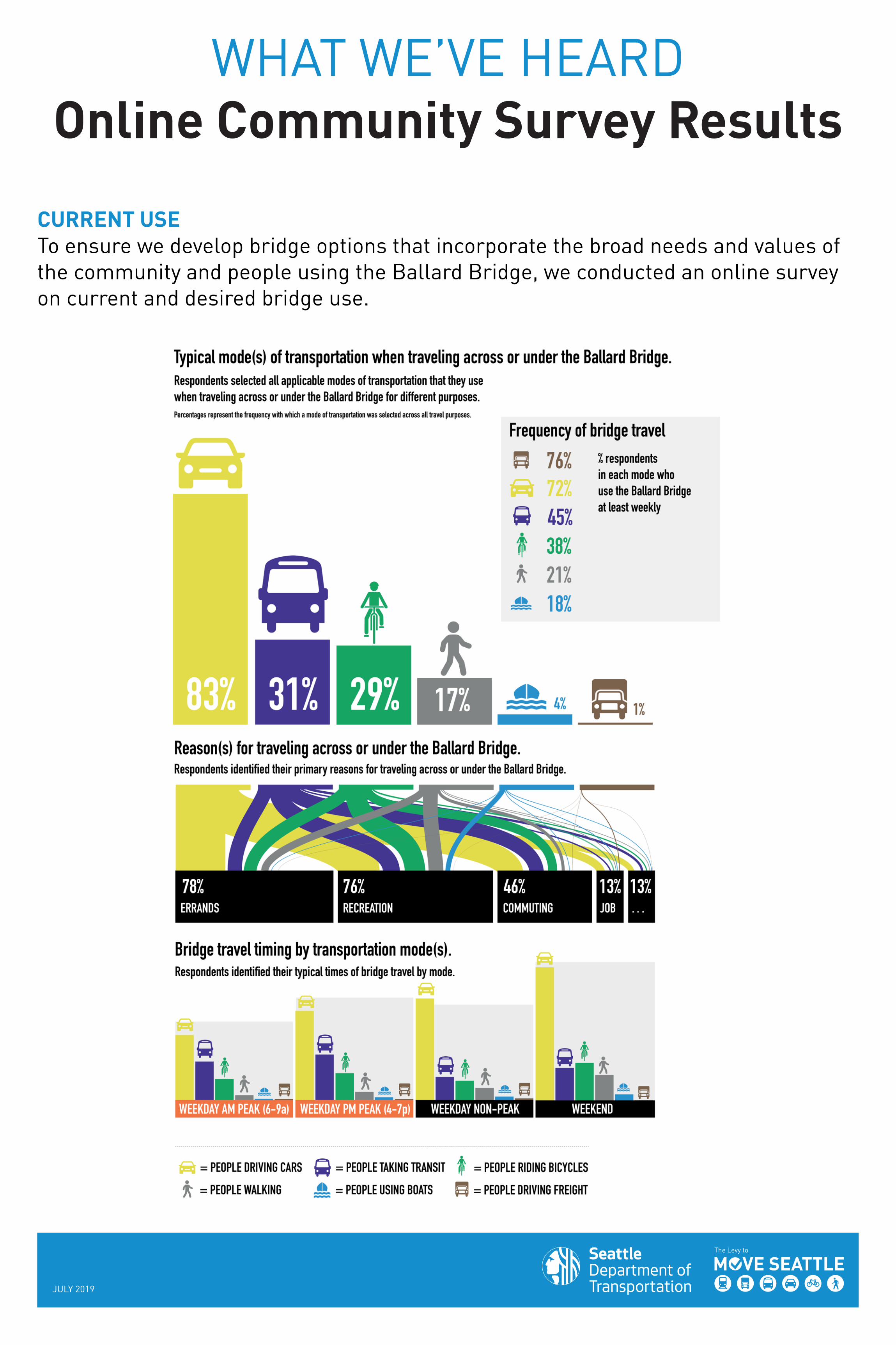
CURRENT USETo ensure we develop bridge options that incorporate the broad needs and values of the community and people using the Ballard Bridge, we conducted an online survey on current and desired bridge use.
JULY 2019
WHAT WE’VE HEARDOnline Community Survey Results
DESIRED USE
JULY 2019
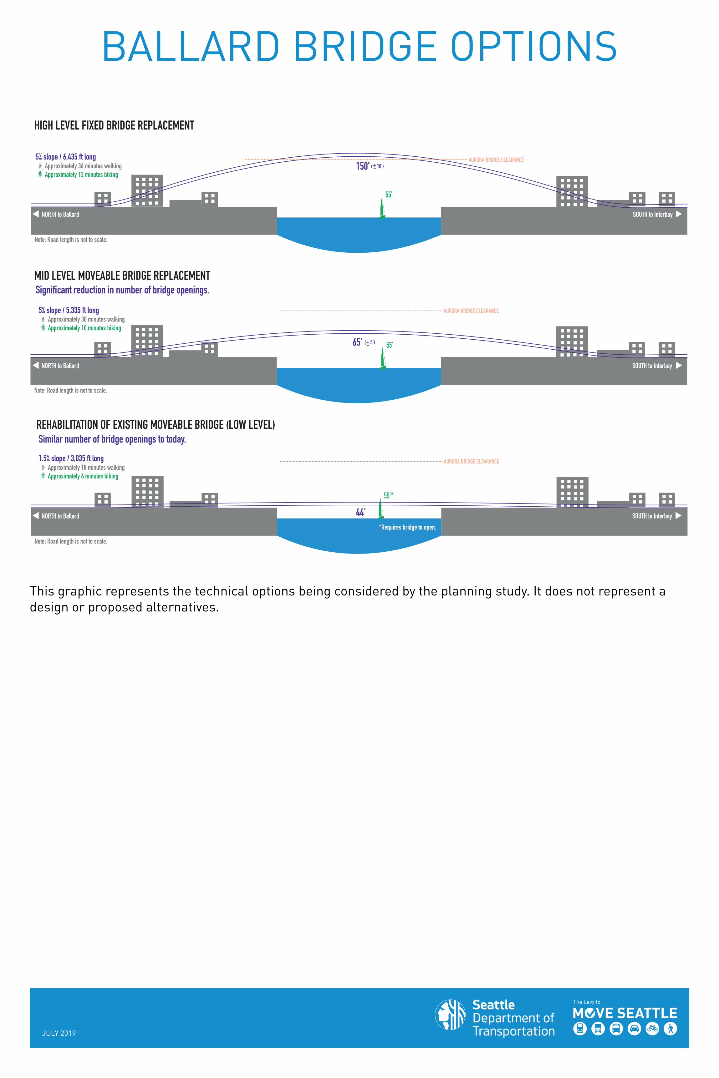
BALLARD BRIDGE OPTIONS
1.5% slope / 3,035 ft long Approximately 18 minutes walking Approximately 6 minutes biking
5% slope / 5,335 ft long Approximately 30 minutes walking Approximately 10 minutes biking
HIGH LEVEL FIXED BRIDGE REPLACEMENT
150’ ( 10’)
MID LEVEL MOVEABLE BRIDGE REPLACEMENT
Note: Road length is not to scale.
65’ ( 5’) 55’
REHABILITATION OF EXISTING MOVEABLE BRIDGE (LOW LEVEL)
44’
55’
*Requires bridge to open.
55’*
AURORA BRIDGE CLEARANCE
Significant reduction in number of bridge openings.
NORTH to Ballard
NORTH to Ballard
NORTH to Ballard
Note: Road length is not to scale.
Note: Road length is not to scale.
SOUTH to Interbay
SOUTH to Interbay
SOUTH to Interbay
BALLARD BRIDGE OPTIONS
AURORA BRIDGE CLEARANCE
AURORA BRIDGE CLEARANCE
5% slope / 6,435 ft long Approximately 36 minutes walking Approximately 12 minutes biking
+-
+-
Similar number of bridge openings to today.
This graphic represents the technical options being considered by the planning study. It does not represent a design or proposed alternatives.
JULY 2019
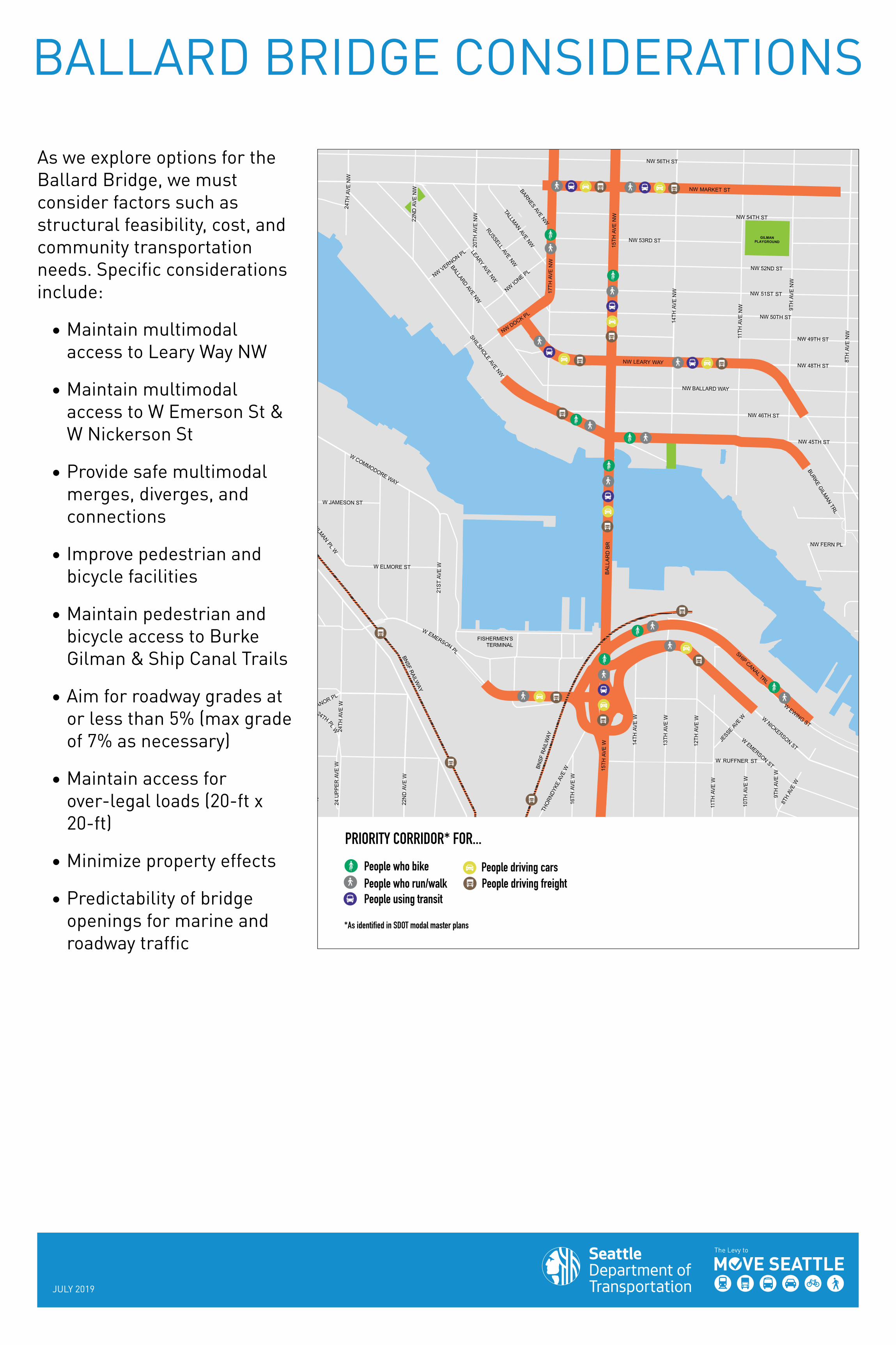
BALLARD BRIDGE CONSIDERATIONS
As we explore options for the Ballard Bridge, we must consider factors such as structural feasibility, cost, and community transportation needs. Specific considerations include:
• Maintain multimodalaccess to Leary Way NW
• Maintain multimodalaccess to W Emerson St &W Nickerson St
• Provide safe multimodalmerges, diverges, andconnections
• Improve pedestrian andbicycle facilities
• Maintain pedestrian andbicycle access to BurkeGilman & Ship Canal Trails
• Aim for roadway grades ator less than 5% (max gradeof 7% as necessary)
• Maintain access forover-legal loads (20-ft x20-ft)
• Minimize property effects
• Predictability of bridgeopenings for marine androadway traffic
3RD
AVE
NW
NW 43RD ST
NW 42ND ST
NW 44TH ST
5TH
AVE
NW
4TH
AVE
NW
BAKE
RA V
EN
W
RO
SSPL
AYG
RO
UN
D
LEARYW
AYNW
6TH
AVE
NW
NW 41ST ST
NW 40TH ST
NW BOWDOIN PL
2ND
AVE
NW
NW 55TH STNW55
THPL
7TH
AVE
NW
3RD
AVE
W
NW 36TH ST
NW 39TH ST
SHIP CANALTRL
6TH
AVE
W
NW 45TH ST
BURKE GILMAN TRL
8TH
AVE
NW
NW FERN PL
NW 48TH ST
NW 49TH ST
12TH
AVE
W
1 3TH
AVE
W
1 4TH
AVE
W
15TH
AVE
W
NW LEARY WAY
11TH
AVE
W
1 6TH
AVE
W
NW 46TH ST
SHILSHOLEAVE
NW
MANOR PL
17TH
AVE
NW
24TH
AVE
NW
22N
DAV
EN
W
9 TH
AVE
W
2 2N
DAV
EW
NW MARKET ST
LEARYAVE
NW
NWDOCK PL
24TH
AVE
W
20TH
AVE
NW
NWIO
NE PL
JESSE
AVE
W10
THAV
EW
RUSSELLAVE
NW
15TH
AVE
NW
W EMERSON ST
W NICKERSON ST
14TH
AVE
NW
11TH
AVE
NW
8TH
AVE
W
W BERTONA ST
9TH
AVE
NW
W EMERSON PL
NW 50TH ST
BALLARDAVE
NW
W RUFFNER ST
BALL
AR
D B
R
NW 56TH ST
THO
RNDY
KEAV
EW
NW VERNON PL
W ELMORE ST
W COMMODORE WAY
NW 54TH ST
W JAMESON ST
24TH PLW
NW 52ND ST
NW 51ST ST
NW BALLARD WAY
BARNESAVE
NW
NW 53RD ST
GILMAN PL W
WEWING ST
AVE
W
TALLMANAVE
NW
24U
PPE
RAV
EW
21S
TAV
EW
GILMANPLAYGROUND
SHIP CANAL TRL
FISHERMEN’S TERMINAL
BNSF RAILWAY
BNSF
RAI
LWAY
NPeople who bikePeople who run/walkPeople using transit
People driving carsPeople driving freight
PRIORITY CORRIDOR* FOR...
*As identified in SDOT modal master plans

JULY 2019
WHAT ELSE SHOULD WE CONSIDER?
Write your feedback on sticky notes