Embed Size (px)
Citation preview
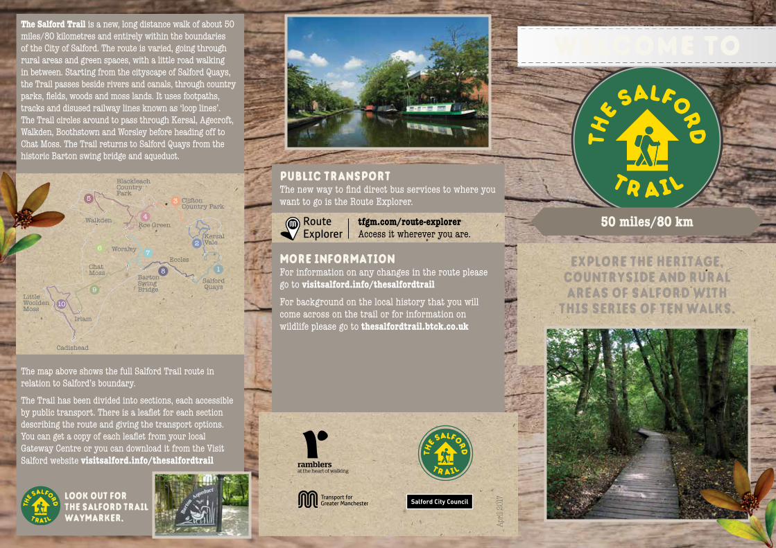
50 miles/80 km
explore the heritage, countryside and rural areas of salford with
this series of ten walks.
welcome toThe Salford Trail is a new, long distance walk of about 50 miles/80 kilometres and entirely within the boundaries of the City of Salford. The route is varied, going through rural areas and green spaces, with a little road walking in between. Starting from the cityscape of Salford Quays, the Trail passes beside rivers and canals, through country parks, fields, woods and moss lands. It uses footpaths, tracks and disused railway lines known as ‘loop lines’. The Trail circles around to pass through Kersal, Agecroft, Walkden, Boothstown and Worsley before heading off to Chat Moss. The Trail returns to Salford Quays from the historic Barton swing bridge and aqueduct.
The map above shows the full Salford Trail route in relation to Salford’s boundary.
The Trail has been divided into sections, each accessible by public transport. There is a leaflet for each section describing the route and giving the transport options. You can get a copy of each leaflet from your local Gateway Centre or you can download it from the Visit Salford website visitsalford.info/thesalfordtrail
SalfordQuays
8 1
2
35
67
9
10
4Roe Green
Walkden
Worsley
ChatMoss
Little Woolden Moss
Cadishead
Irlam
Eccles
BartonSwingBridge
Clifton Country Park
BlackleachCountry Park
KersalVale
the s
alford
t r ail
public transport The new way to find direct bus services to where you want to go is the Route Explorer.
tfgm.com/route-explorer Access it wherever you are.
more informationFor information on any changes in the route please go to visitsalford.info/thesalfordtrailFor background on the local history that you will come across on the trail or for information on wildlife please go to thesalfordtrail.btck.co.uk
April
201
7look out for the salford trail waymarker.

walk 5 - 6.5 miles/10.5km, about 3.5 hours
salford quays to peel park This first leg of the Salford Trail is mainly an urban walk taking you from the most modern development around Salford Quays alongside the Manchester Ship
Canal and the River Irwell. You pass some very important historical buildings and sites, finishing at Peel Park, one of the first Victorian parks.
roe green to walkden A walk from the village of Roe Green going through woods, passing fishing lakes, old lanes, a garden centre and arriving at Blackleach Country Park, then
along loop lines to Walkden Railway Station.
barton bridge to salford quays This is an urban walk close to the Manchester Ship Canal, passing through Eccles, with good views of the inspiring setting of MediaCityUK and Salford Quays.
brookhouse to irlam This walk crosses the wide open spaces of Chat Moss,
with an option to visit a fishermen’s cafe, ending on the main road in Irlam. It can be combined with walk 10 to reach Cadishead.
irlam to cadishead This walk explores the outer reaches of Salford crossing
reclaimed peat bogs and farmland to go alongside Glaze Brook. Passing an old manor house and more pasture, the walk ends at a bus terminus in Cadishead.
walkden to worsley This walk takes the route of now disused railway lines, known locally as ‘loop lines’, to reach a small nature reserve. It then crosses the East Lancs Road and joins the
Bridgewater Canal for the final section leading to Worsley.
worsley to barton or brookhouse This walk goes through Worsley Woods to Monton and along the Bridgewater Canal to Barton Swing Aqueduct. An alternative route along the Salford
Greenway leads to Brookhouse and Peel Green.
peel park to kersal This second leg of the Salford Trail takes you from Salford Museum and Art Gallery along the River Irwell, through Kersal Vale with an option to go over Kersal Moor.
kersal to clifton This walk follows the River Irwell upstream as it meanders through woodland and open spaces to a large country park.
clifton to roe green Whilst fairly near motorways for much of its length, this short section introduces the walker to quiet and peaceful areas of Salford.
walk 1 - 5 miles/8km, about 2.5 hours walk 8 - 3.5 miles/6km, about 2 hours
walk 9 - 5 miles/8km, about 2.5 hours
walk 10 - 7 miles/11.5km, about 4 hourswalk 6 - 5.5 miles/9km, about 2.5 hours
walk 7 - 3.5 miles/6km, about 2 hours
walk 2 -
walk 3 - 5 miles/8km, about 2.5 hours
walk 4 - 3 miles/6km, about 1.5 hours
route a. 5 miles/8km, about 2.5 hoursroute b. 3 miles/5km, about 1.5 hours