Embed Size (px)
Citation preview
Northamptonshire County Council
Wellingborough Part 2 Local Plan
Transport Modelling
Technical Note
August 2017
1
Wellingborough Part 2 Local Plan Transport Modelling
Technical note
Introduction
The North Northamptonshire Joint Core Strategy was adopted in July 2016 and
provides the overarching strategic policies for North Northamptonshire. Policies
specific to the local context are provided by Part 2 Local Plans.
The Borough Council of Wellingborough (BCW) has started to prepare their Local
Plan, called the Plan for the Borough of Wellingborough and undertook public
consultation on an Emerging Plan in 2016. Although the housing and employment
figures in the Local Plan are aligned to what is outlined within the Joint Core Strategy,
there have been some refinements, mostly within the town centre.
Northamptonshire County Council worked very closely with the Joint Planning Unit to
forecast the impact of the housing and employment growth outlined within the Joint
Core Strategy on the highway network and identify the infrastructure necessary to
meet the increase in demand.
The infrastructure that was tested in the Northamptonshire Strategic Transport Model
(NSTM) to support the Joint Core Strategy was informed by previous modelling work.
In Wellingborough town centre, the infrastructure requirement drew directly from the
adopted Town Centre Area Action Plan which was based on higher levels of housing
and retail growth in the town centre.
As part of the development of the Plan for the Borough Council of Wellingborough, it
was appropriate to look again at the infrastructure requirements in the town centre,
now a further refinement of the allocated growth in the town centre is known. In
particular, re-looking at the need for the Northern Interceptor and the associated
changes to the one-way system, as well as other infrastructure on the edge of the town
centre such as the north-south link road.
In order to do this, the revised housing, jobs and retail figures were tested to identify
the forecast impact on the highway network.
This technical report outlines the methodology used, the inputs, results and
conclusions that can be drawn from the transport modelling.
Background
The Northamptonshire Strategic Transport Model (NSTM) is Northamptonshire
County Council’s tool for testing major transport and development proposals. It is a full
four stage transport model covering; trip generation, mode choice, trip distribution and
assignment.

2
The demand model (trip generation/mode choice/trip distribution) and the public
transport model are created using EMME31 software. The highway model is created
using a suite of software called SATURN2 (Simulation and Assignment of Traffic to
Urban Road Networks) originally developed by the University of Leeds and since
marketed and developed in association with Atkins.
The model covers the whole of the county, with an increasingly less detailed coverage
beyond the county borders and is created in accordance with guidance issued by the
Department for Transport.
The model is developed for an average weekday (Monday to Friday) in the AM peak
hour (08:00-09:00) and in the PM peak hour (17:00-18:00). All directional link flows
are shown as actual flows and are measured in Passenger Car Units3 (PCUs). The
baseline model year is 2014.
Inputs
Land use and infrastructure assumptions were provided by the BCW for job, housing
and retail completions from 2014 to 2016 and planned growth to 2031. To avoid
having to build an entirely new baseline model at large expense, the completion
figures were included in the 2031 model to capture the sites that have already come
forward. The 2014 baseline model is the same that was used for the baseline Joint
Core Strategy modelling.
Completions and sites under 10 dwellings within Wellingborough were proportioned
across zones within the urban Wellingborough area, as for smaller villages there is
only one base zone to assign the housing to. Windfall and lapse rate housing was
proportioned across all the base year zones in the District.
The total job, housing and retail figures are provided in Table 1 below, with a more
detailed breakdown available in Appendix A.
Table 1: Job, housing and retail figures to 2031
The infrastructure included in the 2031 model is as outlined in Table 2 (which was
identified in the Joint Core Strategy).
As outlined previously, one of the aims of this transport modelling was to identify
whether in light of the revised housing, jobs and retail proposals for the town centre,
there was still a need for the following pieces of infrastructure:
Northern Interceptor Road
Queen Street two-way; and
1 EMME3 is a software package used to build the Demand Model and the Public Transport Model 2 SATURN is a software package used to build the observed highway model 3 Passenger Car Units is a measure where Heavy Goods Vehicles (HGVs) are converted to equivalent passengers cars using a
conversion factor based on Department for Transport guidance
2031 Jobs 2031 dwellings 2031 A1 Floorspace (sqm)
9,667 8,742 10,592

3
Church Street as bus only
In order to assess the impact on the highway network, these pieces of infrastructure
were not modelled.
Please note that transport modelling for the Joint Core Strategy had already
demonstrated that the Wellingborough Inner Relief Road, also known as north-south
link road, was not required.
Table 2: Infrastructure improvements included in the 2031 model
Junction/link
Improvement
A4500/A509/ Northampton Road Four arm signalised roundabout
A509/Rutherford Drive Improved capacity to A509 northern arm, taking into account Park Farm Way dualling
A509/Turnells Mill Lane/ Embankment
Four arm signalised roundabout
Senwick Road/Elsden Road/Midland Road
Signalised junction
A45/Wilby Way roundabout Four arm signalised roundabout
Park Farm Way dualling Included changes to junction saturation flows
Route 4 to WEAST WEAST development
Route 2 to WEAST WEAST development
Route to WEAST extension WEAST development
Eastern Relief Road (along Sidegate Lane)
WEAST development
Route 6 WEAST development
A509 Niort Way/ Kettering Road/ A510 Northern Way/ Harrowden Road
Northern arm changed to link related to IWIMP, A509 severed and downgraded
A509 Niort Way /Gleneages Drive Four arm roundabout
A509 Niort Way/ Hardwick Road Capacity improvement
A509 Niort Way – Wellingborough North priority access
Between Gleneagles Drive and A509/ A510/ Harrowden Road roundabouts
A509 Northern Way/ Nest Farm Road Four arm roundabout
A510 Northern Way/ Nest Farm Road Four arm roundabout
A510 Northern Way/ A510 Stewarts Road/ Sanders Road
Four arm roundabout to include Route 6 to WEAST
A509 Niort Way Upgraded to dual carriageway
IWIMP link Connecting Isham Bypass to A509 Niort Way
IWIMP link/ Red Hill Street Wellingborough North development
Isham bypass Bypass of Isham

4
Outputs and results
The following outputs were extracted from the transport model:
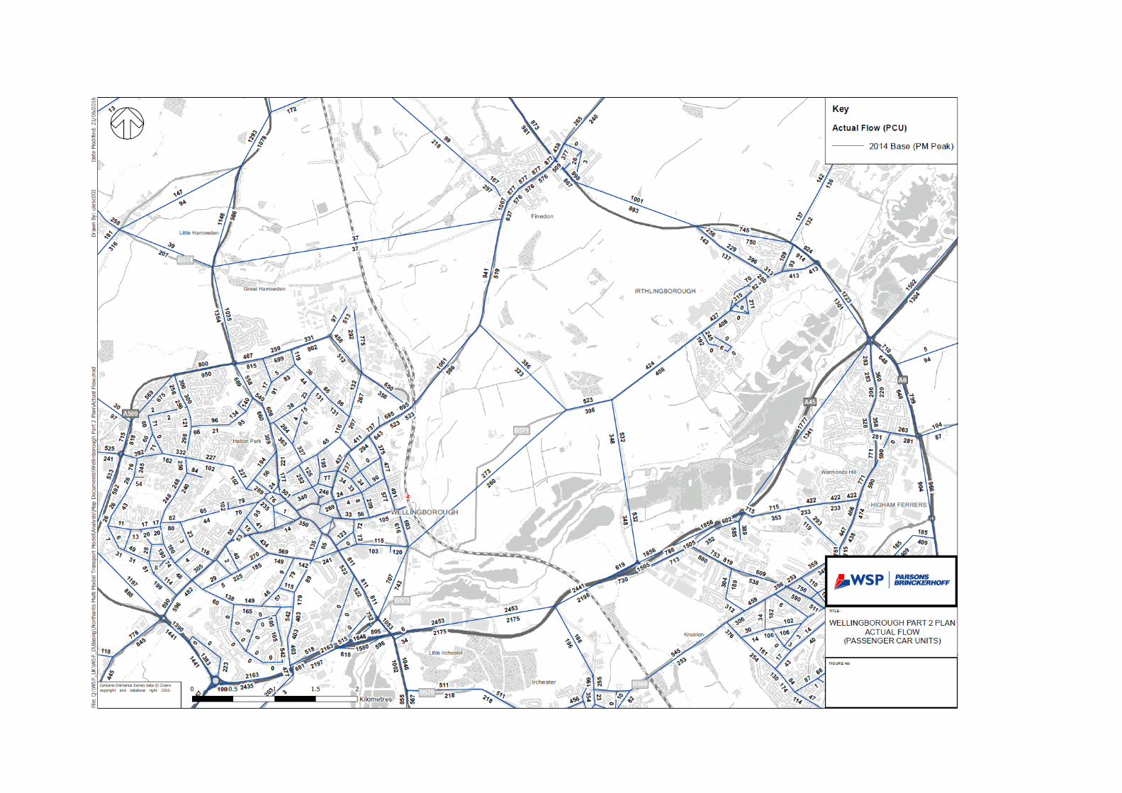
Directional actual link flows
Node volume over capacity (V/C)
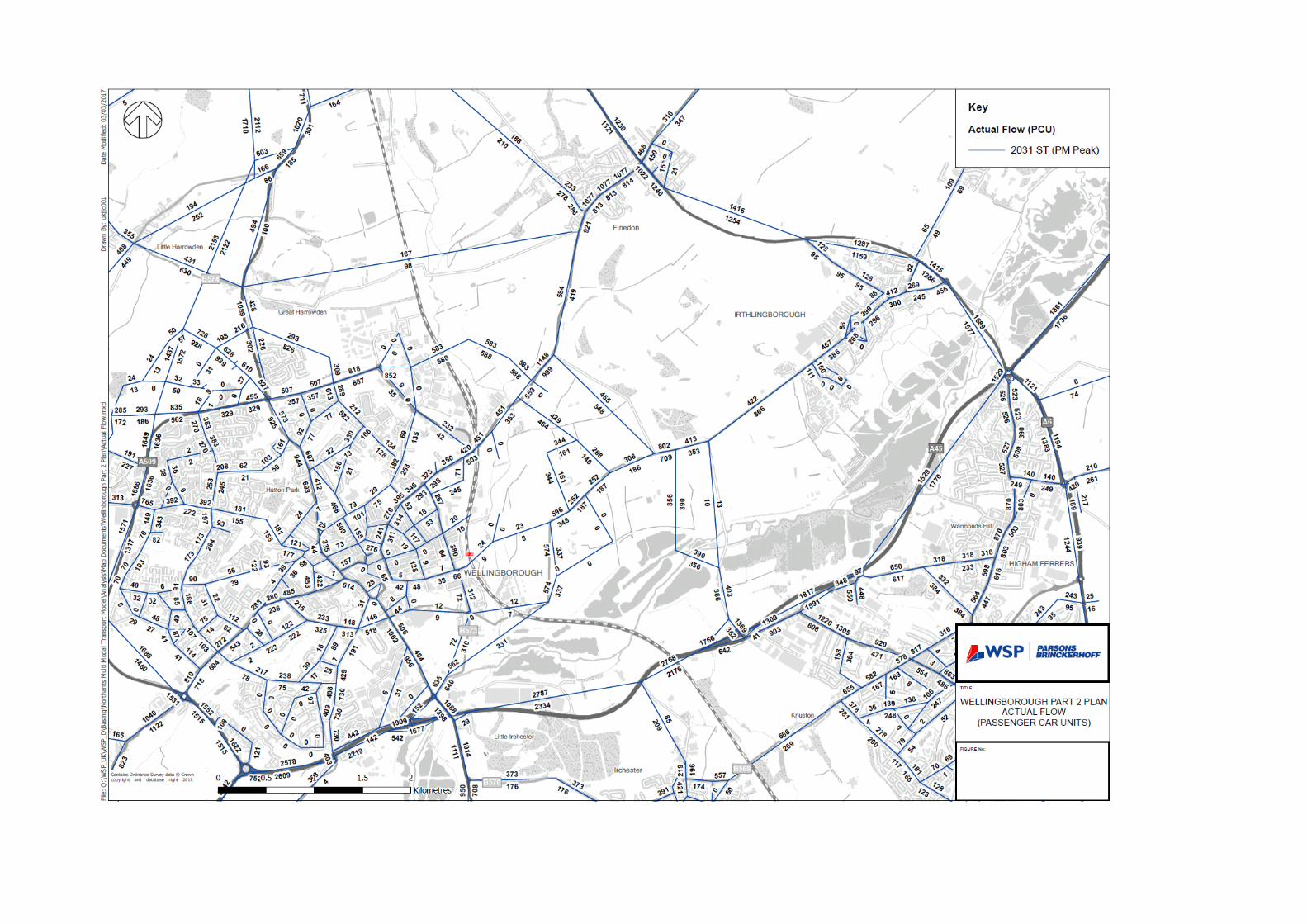
The baseline and 2031 actual flows and volume over capacity plots are available in
Appendix B to E.
Table 3 summarises the actual flow plots for the base year and 2031 in the AM and
PM peak on some of the key corridors.
Table 3: Actual flows on key roads in base and future year scenarios4
Road
2014 AM Peak
Two-way
2031 AM Peak
Two-Way
Difference 2014 PM Peak
Two-way
2031 PM Peak
Two-way
Difference
Actual
% Actual
%
A509 1371 3387 2016 60 1533 3322 1789 54
Harrowden Road
992 1345 353 26 1268 1551 283 18
Finedon Road 582 663 81 12 695 639 -56 -9
Embankment 1575 636 -939 -148 1450 382 -1068 -280
London Road 1297 1947 650 33 1333 1568 235 15
Northampton Road
1412 1538 126 8 1486 1528 42 3
A45 5066 5730 664 12 2831 3067 236 8
Senwick Road
1298 638 -660 -103 1219 384 -835 -217
Eastern Relief Road
- 732 - - - 893 - -
The outputs from the transport modelling of the Plan have been interpreted not only
in light of the change from the baseline figures but also by referencing the transport
modelling produced for the Joint Core Strategy. A summary of the actual flow results
grouped by area is described below.
Town centre
As a consequence of modelling no increase in retail within the town centre, there are
lower traffic flows within the town centre compared to the Joint Core Strategy
scenario. As a consequence, fewer junctions have been identified as over capacity in
the town centre in 2031. However there are still some junctions such as Alma Street/
Cannon Street and Midland Road/Victoria Road which are shown to be approaching
capacity in 2031. The transport modelling also highlights in the PM peak that Little
Green is approaching capacity.
The removal of the Northern Interceptor and the associated changes (such as
Church Street becoming bus-only etc.) does not appear to cause any significant
4 Actual flows are shown in Passenger Car Units (PCUs)

5
junction or link issues as it is mitigated to a large extent by the lower retail growth in
the town centre.
Edge of town centre
The infrastructure related to Wellingborough East appears to be showing some
pressure in the transport modelling, however this infrastructure has already been
extensively tested as part of Wellingborough East development and deemed to be
sufficient so this is not a concern. Similarly, some of the infrastructure to the north of
Wellingborough related to Isham bypass and IWIMP is showing some capacity
constraints. Again, Isham bypass and IWIMP has been subject to transport
modelling, and is also being revisited as part of the detailed design of Isham bypass
and designed accordingly, so the highway authority is content that any design
modifications will be picked up through this process.
As expected, both the Embankment and Senwick Road see a decrease in traffic due
to the implementation of the Eastern Relief Road and alternative access points to
Wellingborough East changing the distribution of traffic in this area of the town.
Traffic flows on Finedon Road and Northampton Road stay broadly similar between
2014 and 2031. Traffic flows on Harrowden Road and London Road are forecast to
increase by a similar percentage (26 to 33 percent in the AM peak and 15 to 18
percent in the PM peak).
Principal and strategic network
The greatest increase in two-way traffic flows is on the A509 Park Farm Way which
is a product of the increase in cumulative travel demand between Wellingborough
and Kettering as a result of the proposed growth, and the dualling on this section
which enhances journey times, making a more attractive route to traffic compared to
alternative routes.
Traffic flows on the A45 are broadly in line with those modelled for the Joint Core
Strategy, with traffic flows on the A45 forecast to increase by 12 percent in the AM
peak and 8 percent in the PM peak.
The A45 Wilby Way roundabout and the junctions around Wellingborough and
further afield at Rushden continue to show pressure, possibly a product of improving
flows at Chowns Mill and Rushden Lakes causing issues further along the A45.
Junction performance
Volume over capacity (V/C) is a measure of how congested a particular junction
(node) is and shows the figure for the most congested arm.
Any figures of over 85 percent suggest that the junction is over capacity; figures
between 75 and 85 percent suggest a junction is approaching capacity. Anything
over 100 percent is considered severe congestion. These outputs are useful to
understand where junctions may require an intervention to increase capacity and
improve performance.
6
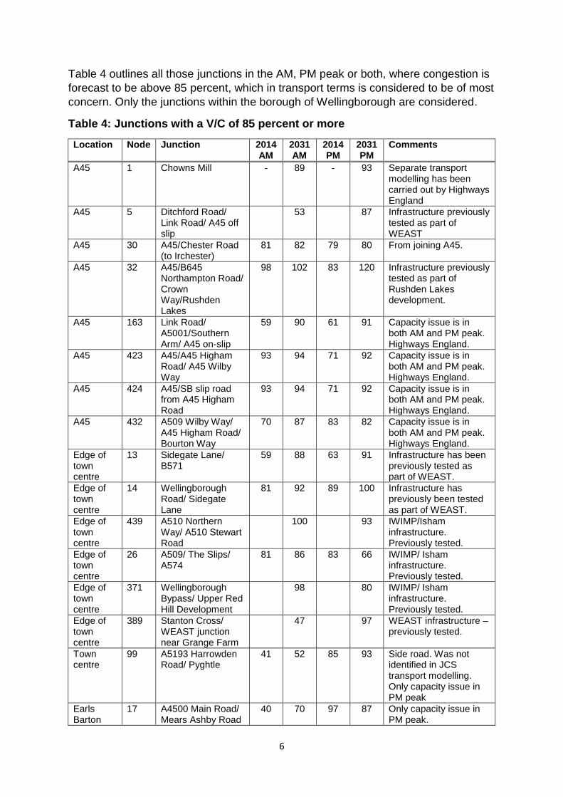
Table 4 outlines all those junctions in the AM, PM peak or both, where congestion is
forecast to be above 85 percent, which in transport terms is considered to be of most
concern. Only the junctions within the borough of Wellingborough are considered.
Table 4: Junctions with a V/C of 85 percent or more
Location Node Junction 2014 AM
2031 AM
2014 PM
2031 PM
Comments
A45 1 Chowns Mill - 89 - 93 Separate transport modelling has been carried out by Highways England
A45 5 Ditchford Road/ Link Road/ A45 off slip
53 87 Infrastructure previously tested as part of WEAST
A45 30 A45/Chester Road (to Irchester)
81 82 79 80 From joining A45.
A45 32 A45/B645 Northampton Road/ Crown Way/Rushden Lakes
98 102 83 120 Infrastructure previously tested as part of Rushden Lakes development.
A45 163 Link Road/ A5001/Southern Arm/ A45 on-slip
59 90 61 91 Capacity issue is in both AM and PM peak. Highways England.
A45 423 A45/A45 Higham Road/ A45 Wilby Way
93 94 71 92 Capacity issue is in both AM and PM peak. Highways England.
A45 424 A45/SB slip road from A45 Higham Road
93 94 71 92 Capacity issue is in both AM and PM peak. Highways England.
A45 432 A509 Wilby Way/ A45 Higham Road/ Bourton Way
70 87 83 82 Capacity issue is in both AM and PM peak. Highways England.
Edge of town centre
13 Sidegate Lane/ B571
59 88 63 91 Infrastructure has been previously tested as part of WEAST.
Edge of town centre
14 Wellingborough Road/ Sidegate Lane
81 92 89 100 Infrastructure has previously been tested as part of WEAST.
Edge of town centre
439 A510 Northern Way/ A510 Stewart Road
100 93 IWIMP/Isham infrastructure. Previously tested.
Edge of town centre
26 A509/ The Slips/ A574
81 86 83 66 IWIMP/ Isham infrastructure. Previously tested.
Edge of town centre
371 Wellingborough Bypass/ Upper Red Hill Development
98 80 IWIMP/ Isham infrastructure. Previously tested.
Edge of town centre
389 Stanton Cross/ WEAST junction near Grange Farm
47 97 WEAST infrastructure – previously tested.
Town centre
99 A5193 Harrowden Road/ Pyghtle
41 52 85 93 Side road. Was not identified in JCS transport modelling. Only capacity issue in PM peak
Earls Barton
17 A4500 Main Road/ Mears Ashby Road
40 70 97 87 Only capacity issue in PM peak.

7
Town Centre
113 Broad Green/Hardwick Road
44 34 64 91 Capacity issue is in PM peak.
Finedon 248 A510 Wellingborough Road/ Bell Hill
102 87 102 87 Capacity issue is in AM and PM peak.
Finedon 21 A6/A510 71 78 66 91 Capacity issue is in the PM peak.
Isham 375 Isham Bypass/ Hill Top Road/ A509 Kettering Road
100 92 IWIMP/Isham infrastructure. Previously tested.
Isham 419 Isham Bypass Link/ A509 Kettering Road
73 93 IWIMP/Isham infrastructure. Previously tested.
Of the junctions identified in Table 4, there are eight junctions where infrastructure
has previously been tested and deemed fit for purpose as part of development
proposals:
Sidegate Lane/ B571
Wellingborough Road/ Sidegate Lane
A510 Northern Way/ A510 Stewart Road
A509/ The Slips/ A574
Wellingborough Bypass/ Upper Red Hill Development
Stanton Cross/ WEAST junction near Grange Farm
Isham Bypass/ Hill Top Road/ A509 Kettering Road
Isham Bypass Link/ A509 Kettering Road
No further investigation is required at these junctions and the infrastructure in the
Emerging Plan IDP is sufficient.
There are five junctions managed by Northamptonshire County Council which have
been forecast to be over capacity in either the AM, PM or both peaks. These
junctions have been considered in further detail and improvements (if appropriate)
identified in Table 5.
Table 5: Junctions considered for further improvement
Junction Comment Improvement identified
A5193 Harrowden Road/ Pyghtle (Wellingborough)
This is a product of the way traffic is loading onto the network in the model rather than an issue.
No improvement required.
A4500 Main Road/ Mears Ashby Road (Earls Barton)
Only just overcapacity in the PM peak, and is an improvement over the existing modelled situation.
No improvement required.
Broad Green/Hardwick Road (Wellingborough)
This junction has been looked at previously and due to land constraints there is
No improvement required.

8
minimal opportunities for improvement at this location.
A510 Wellingborough Road/ Bell Hill (Finedon)
This is a product of the way traffic is loading onto the network in the model rather than an issue.
No improvement required.
A6/A510 (Finedon) Growth on the A6 and A510 will create pressure at this junction in particular in the PM peak.
Minor improvement may be required to roundabout (minor widening, signing and lining). Cost estimate £100k.
The remaining eight junctions are managed by Highways England. The flows
identified are in line with those identified in the Joint Core Strategy, however advice
should be sought from them regarding any further improvements they deem
necessary.
Conclusion
The transport modelling has demonstrated that the lower traffic flows within the town
centre compared to the Joint Core Strategy scenario results in fewer junctions being
identified as over capacity, however there are still some junctions such as Alma
Street/ Cannon Street and Midland Road/Victoria Road which are shown to be
approaching capacity in 2031 so may require improvement in the next Plan period.
The removal of the Northern Interceptor and the associated changes (such as
Church Street becoming bus-only etc.) does not appear to cause any significant
junction issues as it is mitigated to a large extent by the lower retail growth in the
town centre.
Of the new junctions highlighted as having a capacity issue that are managed by
Northamptonshire County Council, further investigation has identified that only the
A6/A510 junction is deemed to require an improvement.
The other junctions have either been disregarded as an issue due to the way in
which the NSTM models side road junctions, or previous investigations have
identified that there is no feasible scheme available due to land constraints.

Appendix A – Development assumptions
NSTM Zone
Development 2031 Jobs 2031
Dwellings
2031 A1 Floor-space (sqm)
Retail Space Value (£k)
97 Milner Road Finedon 30
97 PBW allocation 60
97 Completions/sites under 10 dws in Finedon 44
98 Brookside Garage Units 1 To 2, 347, Wellingborough Road, Finedon, Wellingborough
-1
98 WEAST SUE 5304 2980 2500 2631
126 Land off Austin Close 75
126 Land South of James Street 75
127 Completions/sites under 10 dws in Irchester 19
129 37 Valley Road, Wellingborough 15 16
129 Windsor Road 60
130 26, Knox Road, Wellingborough, NN8 1HW -18
130 Former Knapp Tool and Whitworth Bakery Site, London Road, Wellingborough, NN8 2DP
130 Land at London Road 3300 3473
131 80 Leyland Trading Estate, Irthlingborough Road, Wellingborough, NN8 1RT
1
131 Nene Court 484 509
131 The Old Granary Grange Farm, Irthlingboorugh Road, Wellingborough
-2
132 Saxby Bros Ltd, Chester Road 56
133 6, Phoenix Court, Wellingborough, NN8 2QE 3
133 Denington Road 1064 1120
133 Hampton Steel & Wire Limited, 39 43, London Road, Wellingborough, NN8 2DP
5
134 1, Berrymoor Court, Wellingborough, NN8 2DL 84 88
138 Northampton Road Post Office, Northampton Road, Wellingborough
28 29
139 66-74 Lea Way Wellingborough Northamptonshire NN8 3NG 23
144 Land Between Road And Rylstone Park Farm Way Wellingborough Northamptonshire
53
145 2-6, Huxley Close, Wellingborough, NN8 6AB 30
145 31-35, Booth Drive, Wellingborough, NN8 6GR 5
145 34-38, Rutherford Drive, Park Farm Industrial Estate, Wellingborough, NN8 6AE
17
145 39-44, Davy Close, Wellingborough, NN8 6XX
145 Land rear of 14 to 38 and fronting, Sywell Road, Davy Close, Wellingborough, NN8 6XX
31
145 Mahle Powertrain, 31, Booth Drive, Park Farm Industrial Estate, Wellingborough, NN8 6GR
160
145 Plot U adjoining, Rutherford Drive, Wellingborough, NN8 6AQ 46
145 Unit 15, Regent Park 37 Booth Drive, Wellingborough, NN8 6GR 6
150 Hardwick Park 45
150 Completions/sites under 10 dws in Hardwick 5
150 Completions/sites under 10 dws in Orlingbury 1

150 The Lodge Manor Farm 2, Taggies Yard, Orlingbury, Kettering, NN14 1QH
1
150 Wellingborough North SUE 1220 1284
151 1, Fleming Close, Park Farm Industrial Estate, Wellingborough, NN8 6JF
2
151 5, Faraday Court, Wellingborough, NN8 6XY 3
151 Unit D, 1 - 5, Whittle Close, Wellingborough, NN8 6TY 6
153 16-18, Stewarts Road, Wellingborough, NN8 4RJ 28
153 2, Trojan Centre, Finedon Road Industrial Estate, Wellingborough, NN8 4ST
3
153 2-20, Don White Road, Wellingborough, NN8 4FT 60
153 4 Saxon Court, Bradfield Road, Wellingborough, NN8 4RQ -5
153 40-44, Bradfield Road, Wellingborough, NN8 4HB
153 5, Nielson Road, Finedon Road Industrial Estate, Wellingborough, NN8 4PE
153 5, Stanton Close, Wellingborough, NN8 4HN 87
153 61-65, Sanders Road, Wellingborough, NN8 4NL 5
153 7-11, Stewarts Road, Wellingborough, NN8 4RJ 10
153 99, Sanders Road, Wellingborough, NN8 4NL -2
153 Univar Ltd, 9-11 Links Road, Wellingborough, NN8 4EY 2
154 3-4 (Larner Pallets), Bevan Close, Wellingborough, NN8 4BL 109
154 Land Between Finedon Road and Nest Lane 100
154 Rear 56 Nest Lane 16
155 1, Grant Road, Wellingborough, NN8 1ES 10
155 Leys Road/Highfield Road 40
156 Completions/sites under 10 dws in Grendon 2
157 29a, Doddington Road, Wollaston, NN29 7PR 68
157 Land East of Hookhams Path Wollaston 80
157 Completions/sites under 10 dws in Wollaston 25
158 Completions/sites under 10 dws in Wilby 1
158 Wilby Church Of England Primary School, Church Lane, Wilby, Wellingborough, NN8 2UG
-1
159 120-140, Glebe Road, Mears Ashby, Northampton, NN6 0DL 110 116
159 240, Sywell Road, Mears Ashby, Northampton, NN6 0DL 14
159 Completions/sites under 10 dws in Mears Ashby 14
160 204, Holcot Lane, Sywell, Northampton, NN6 0BG 24
160 Hendrickson Site 7 (Unit 35), Sywell Aerodrome, Wellingborough Road, Sywell, Northampton, NN6 0BN
73
160 Minton Distribution Centre Wellingborough Road Sywell 120
160 Site B Unit 1 Lancaster Hanger, Wellingborough Road, Sywell, Northampton, NN6 0BN
55
160 Completions/sites under 10 dws in Sywell 9
160 Thistledown Barn, 204 Holcot Lane, Sywell, Northampton, NN6 0BG
63
161 East Lodge Farm, Washbrook Lane, Ecton 84 88
161 Completions/sites under 10 dws in Ecton 9
162 108 The Grange, Northampton Road, Earls Barton, Northampton, NN6 0JH
46

162 18-20, Baron Avenue, Earls Barton, Northampton, NN6 0JE 22
162 38, Main Road, Earls Barton, Northampton, NN6 0TW 9
162 Land Adj 16, 80 Main Road, Earls Barton, Northampton 31
162 Land To The North off Main Road, and Northampton Road, Earls Barton, Northampton
280
163 23-27, Titley Bawk Avenue, Earls Barton, Northampton, NN6 0LA
2
163 58 Bowlers Yard High Street Earls Barton NN6 0NA 11
244 15 Ladywell Court, Linnet Close, Wellingborough, NN8 4UL 3
418 31b, Alma Street, Wellingborough, NN8 4DH -82
418 Former Gold Street, 106 Gold Street 468 493
418 Site G TCAAP - Alma St/ Cambridge St Backlands 50
418 Site I TCAAP - PO Sorting Office 23 717 755
418 Wellingborough Medical Centre 106, Gold Street, Wellingborough, NN8 4ES
27 28
446 2A, High Street, Wellingborough, NN8 4HR -8
446 3 Queen Street, Wellingborough 29 31
446 38a British Rail Sports And Social Club Broad Green Wellingborough Northamptonshire NN8 4LH
60
446 39b, Cambridge House, Cambridge Street, Wellingborough, NN8 1DW
446 59, High Street, Finedon, Wellingborough, NN9 5JN
446 60, Midland Road, Wellingborough, NN8 1LU
446 Charlton House 15, Great Park Street, Wellingborough, NN8 4PR
14
446 Croyland Abbey and Croyland Hall, 1A Tithe Barn Road, Wellingborough, Northants, NN8 1BJ
14
446 Everyday Champions Church, 47 Havelock Street, Wellingborough, NN8 4LG
3
446 Railway Sports & Social Club 38a, Broad Green, Wellingborough, NN8 4LH
20
446 Site C High Street Site 113 356 375
447 2-4, Arthur Street, Wellingborough, NN8 3HH 12
447 George Cox Shoes Westfield Road NN8 3HB 25
447 Rear of 4-8, Barnabas Street, Wellingborough, NN8 3HB 1
448 Former Victoria Junior School Stanley Road, Wellingborough, Northamptonshire, NN8 1EA
23
448 Former Waendel Centre, 86 Stanley Road, Wellingborough, NN8 1DY
14
448 Gilmore & Vale Ltd 9 Mill Road Wellingborough NN8 1PF 14
459 Former A J Sectional between 11 and 11A, Thrapston Road, Finedon, Wellingborough, NN9 5DG
40
466 Completions/sites under 10 dws in Bozeat 18
467 7, Williams Way, Wollaston, Wellingborough, NN29 7RQ
469 Flat 39A, The Square, Earls Barton, Northampton, NN6 0NA 106 112
469 Land Rear Of 1 To 27, Thorpe Road, off Station Road, Earls Barton
39
469 Completions/sites under 10 dws in Earls Barton 122
471 Grove Farm 39, High Street, Great Doddington, NN29 7TQ 1
472 12-14, Edmonds Close, Wellingborough, NN8 2QY 2
472 90, Denington Road, Wellingborough, NN8 2RB 100

472 The Open University, 65-69 Denington Road, Wellingborough, NN8 2QH
68
498 304 Former Scrapyard, Station Road, Isham, Kettering, NN15 5NT
57
498 Furnace Lane, Finedon Sidings, Little Harrowden, Wellingborough, NN9 5NY
34
498 Completions/sites under 10 dws in Great Harrowden 1
498 Completions/sites under 10 dws in Little Harrowden -13
649 WEAST - additional capacity
652 WEAST - Grange Farm, Irthlingborough Road, Wellingborough
652 WEAST - Independent Landowners - Irthlingborough Grange 44
652 WEAST - Independent Landowners - Mandalin House
665 30 High Street, Wellingborough, Northamptonshire 10
672 Park Farm/Shelley Way 600
682 Wellingborough North (Land off the A509 Niort Way and A510 Northen Way and south of Great Harrowden Wellingborough)
215
683 Wellingborough North (Land off the A509 Niort Way and A510 Northen Way and south of Great Harrowden Wellingborough)
215
684 Wellingborough North (Land off the A509 Niort Way and A510 Northen Way and south of Great Harrowden Wellingborough)
215
685 Wellingborough North (Land off the A509 Niort Way and A510 Northen Way and south of Great Harrowden Wellingborough)
215
686 Wellingborough North (Land off the A509 Niort Way and A510 Northen Way and south of Great Harrowden Wellingborough)
107
687 Wellingborough North (Land off the A509 Niort Way and A510 Northen Way and south of Great Harrowden Wellingborough)
667
688 Wellingborough North (Land off the A509 Niort Way and A510 Northen Way and south of Great Harrowden Wellingborough)
215
688 Wellingborough North Additional capacity 265
692 140-160 Appleby Lodge, Sywell Road, Wellingborough, NN8 6BS
2500
707 Phase 2b Land off Eastfield Road 131
707 Phase 3 Land off Eastfield Road 75
724 Land Off, The Sorrels, Isham, Kettering 16
724 Completions/sites under 10 dws in Isham 14
735 Wellingborough North (Land off the A509 Niort Way and A510 Northen Way and south of Great Harrowden Wellingborough)
321
- Lapse Rate (11% of all sites of less than 10 dws) -27
- Windfall (Average of last 6 years on sites of less than 10 dwellings)
564
- Completions/sites under 10 dws in Wellingborough 737
Total 9667 8742 10592 11147

Appendix B – Base year actual flows (2014 AM and PM Peak)

Appendix C – Future Year flows (2031 AM and PM Peak)

Appendix D – Baseline volume over capacity (2014 AM and PM peak)


Appendix E – Future year volume over capacity (2031 AM and PM Peak)