Embed Size (px)
Citation preview
Brisbane City Plan 2000 — Volume 1Amended 15 April 2011
Chapter 4, page 259b
Wes
t E
nd—
Wo
ollo
ong
abb
a D
istr
ict
Loca
l Pla
nC
hapt
er 4
: Loc
al P
lans
West End—Woolloongabba District Local Plan
1 Introduction
This Local Plan contains specific additional local planning requirements. Where it conflicts with the requirements of the City Plan, this Local Plan prevails. In using this Local Plan, reference should also be made to Section 1.1—Using a Local Plan at the front of this chapter.
2 Development principles
2.1 The continued co–existence of the area’s diverse mix of residential, industrial, commercial, retail and community uses (e.g. schools, churches and cultural facilities) will be strongly encouraged to provide social and built form diversity.
2.2 The major institutions located in or adjoining the Local Plan area (including the Queensland Cultural Centre, South Bank, the Queensland Conservatorium Griffith University, the Mater and Princess Alexandra Hospitals, Southbank Institute and Queensland University of Technology) will remain as focal points for their important services, facilities and employment opportunities. They are to be enhanced by the encouragement of:
• ancillary uses such as offices and accommodation in and around these institutions to meet their growing needs
• better access to them by all transport modes.
2.3 The Buranda shopping centre and the strip shopping centres along Boundary Street, Annerley and Ipswich/Logan Roads will continue to service the retail and business needs of the local community. In particular, the West End Centre is to maintain its traditional character and pedestrian friendly environment. The Woolloongabba Centre will maintain its historically
significant presence to Logan Road and Stanley Street, with development accommodating new active street frontages and high density residential on the western side of Ipswich Road.
2.4 The Local Plan area will continue to provide a diverse mix of housing that serves the needs of households in the community at different stages in their life cycle.
2.5 Development in the Local Plan area is to complement the traditional ‘timber and tin’ character by respecting the character streetscapes and amenity of the area. The West End Estate and pre 1946 housing is to be protected.
2.6 The River’s edge will remain as a dominant feature of the Local Plan area providing an important network of parks that are well used by the local and Citywide community. New development will enhance these parks and this riverside setting through improving access to these parks, the use of appropriate building setbacks, materials and design, and landscaping.
2.7 The high level of accessibility (public transport, walking and cycling) to both the City Centre and local services/facilities will be maintained and enhanced through:
• i m p l e m e n t i n g C o u n c i l – a p p r o v e d recommendations of the South Brisbane Mobility Study
• ensuring new development provides appropriate access paths, landscaping and pedestrian awnings
2.8 Development in the Local Plan area maintains and enhances views of significance to the City and locality from the public realm:
• across the West End peninsula to the City Centre and the D’Aguilar Ranges
• to significant landmarks within the locality
• to the Brisbane River.
2.9 Existing community facilities are to be protected and new residential development in close proximity to venues for the pursuit of sporting and recreation activities are to be adequately buffered from noise and lighting impacts to ensure the ongoing provision of cultural, social or community services. Opportunities for new community facilities and services are encouraged and adequately supported by Council.
3 Precinct intents
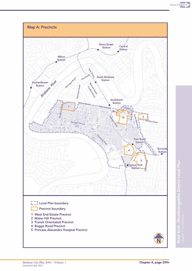
Map A—Precinct Map indicates the precincts of this Local Plan.
Amended 15 April 2011Brisbane City Plan 2000 — Volume 1Chapter 4, page 259c
Wes
t E
nd—
Wo
ollo
ong
abb
a D
istr
ict
Loca
l Pla
nC
hapt
er 4
: Loc
al P
lans
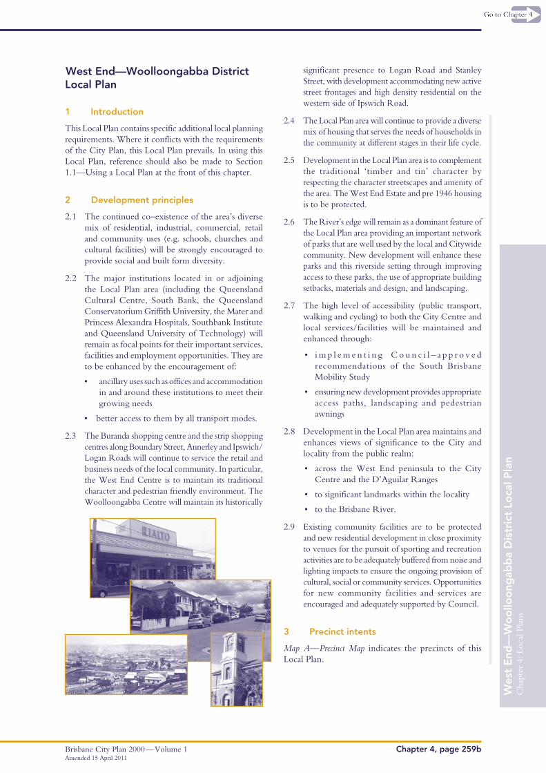
3.1 Precinct 1—West End Estate
This precinct contains a relatively intact, historically significant grouping of small nineteenth century and early twentieth century workers cottages characterised by one storey timber and tin detached houses on small narrow lots. These houses are to be preserved in their current form. Their setting is to be protected so that the precinct retains its original character. Significant changes that alter the form, scale, and setting of the buildings are not supported.
3.2 Precinct 2—Mater Hill
Sub–precinct 2(a)
Office and shop activities on sites fronting Stanley Street provide an active street frontage to reinforce the commercial building form of Stanley Street. Residential uses will be supported on the upper storeys, given the sub–precinct’s location next to the Mater Hospital, the South Bank Railway Station and Busway Stations.
Sub–precinct 2(b)
Hospital supporting uses such as ‘outpatient’ services are supported on lower levels fronting Hancock Street, where impacts on surrounding residential uses are addressed. Short term accommodation will also be supported, given its location next to the Mater Hospital, the South Bank Railway Station and Busway Stations.
Sub–precinct 2(c)
This sub–precinct contains the Mater Hospital, and includes major hospital and medical facilities, as well as ancillary uses including administration, educational and research facilities, specialty services, and a range of other services for the use of employees, patients and visitors to the hospital. Scale and intensity of development should be respectful of the existing heritage buildings in the sub–precinct and of nearby residential and educational uses in terms of building heights, overshadowing and traffic impacts.
Major hospital and medical facilities with a high intensity built form and scale should be concentrated north of the heritage area to maximise access to and from car parking facilities and the Mater Hill Busway Station. Lower intensity ancillary uses that support the hospital and medical facilities should be located in the southern portion of the sub–precinct near Clarence Street.
3.3 Precinct 3—Transit Oriented
State Government facilities such as Goprint are located in this precinct. Given its location close to the
Woolloongabba Busway Station and shopping activities, this precinct represents a major future redevelopment opportunity. A mix of uses, such as commercial, retail, high density residential, low cost housing, park and community uses would be supported.
3.4 Precinct 4—Boggo Road
This precinct should be developed as an integrated urban village comprising significant employment, a mix of residential densities, affordable and adaptable housing, a small convenience shopping facility, community facilities and park, due to its proximity to the City Centre, major hospitals, educational institutions and public transport.
The precinct should have a busway station on a busway corridor linking Buranda Busway Station with the University of Queensland.
Development is to have regard for the residential neighbours and the heritage significance of the Gaol. Any extension of Merton Road into this precinct will not be supported.
3.5 Precinct 5—Princess Alexandra Hospital
The Princess Alexandra Hospital is an important medical facility for Brisbane and the region. The land in the north of the precinct provides an opportunity for the development of education and research facilities that would service this and other institutions, such as universities.
This precinct is designated as Community Infrastructure under the Act and as such, development is exempt from the City Plan. However, it is recommended that future development address:
• traffic implications of the development
• pedestrian and cycle access and integration with existing and future public transport
• architectural treatment of the buildings and high quality landscaping, given the high visibility of the site.
4 Level of assessment
The following tables contain exceptions to the level of assessment, overriding the levels of assessment in Chapter 3.
A preliminary approval may change the level of assessment identified in these tables. The trigger for assessment in the level of assessment table is material change of use and/or building work (associated with a use or structure specified in the level of assessment table) unless otherwise specified.
Brisbane City Plan 2000 — Volume 1Amended 15 April 2011
Chapter 4, page 259d
Wes
t E
nd—
Wo
ollo
ong
abb
a D
istr
ict
Loca
l Pla
nC
hapt
er 4
: Loc
al P
lans
4.1 Precinct 1—West End Estate
Code Assessment Applicable Codes
Notifiable
1. House West End–Woolloongabba District Local Plan Code
Impact Assessment Relevant Codes
Generally appropriate
1. House where not complying with Acceptable Solutions A2.1, A3.1, A4.1, A4.2, A4.3, A5.1, A5.2, A6, A7.2, in Precinct 9 of the West End Woolloongabba District Local Plan Code
West End–Woolloongabba District Local Plan Code
4.2 Precinct 2—Mater Hill
Code Assessment Applicable Codes
Sub–precinct 2(b)
1. Medical Centre where not exceeding 2 storeys where part of a residential building and fronting Hancock Street
West End–Woolloongabba District Local Plan Code
Sub–precinct 2(c)
1. Club West End–Woolloongabba District Local Plan Code, Centre Amenity and Performance Code, Centre Design Code and Community Use Code (for Community Facility only) Industrial Amenity and Performance Code
2. Community Facilities
3. Indoor Sport and Recreation
4. Industry where
• for scientific or technological research related to medical services
• not identified in Schedule 1 or Schedule 2
5. Medical Centre
6. Office
7. Restaurant
8. Shop
5 West End—Woolloongabba District Local Plan Code
This Code provides additional and/or alternative Acceptable Solutions to the Codes in Chapter 5 and takes precedence over the Codes in Chapter 5.
Where an Acceptable Solution or the corresponding Performance Criterion in this Local Plan Code directly varies from an Acceptable Solution and Performance Criterion in the Local Plan Code in Chapter 5, the
Acceptable Solution and Performance Criterion in this Local Plan Code takes precedence. All remaining Acceptable Solutions and Performance Criteria from applicable or relevant generic Codes in Chapter 5 will continue to apply.
The purpose of this Code is to ensure that development in the Local Plan area is consistent with the development principles and precinct intents of this Local Plan.
Amended 15 April 2011Brisbane City Plan 2000 — Volume 1Chapter 4, page 259e
Wes
t E
nd—
Wo
ollo
ong
abb
a D
istr
ict
Loca
l Pla
nC
hapt
er 4
: Loc
al P
lans
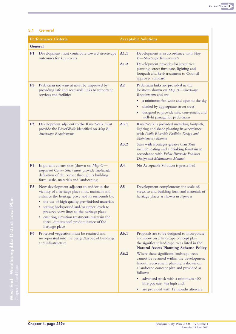
5.1 General
Performance Criteria Acceptable Solutions
General
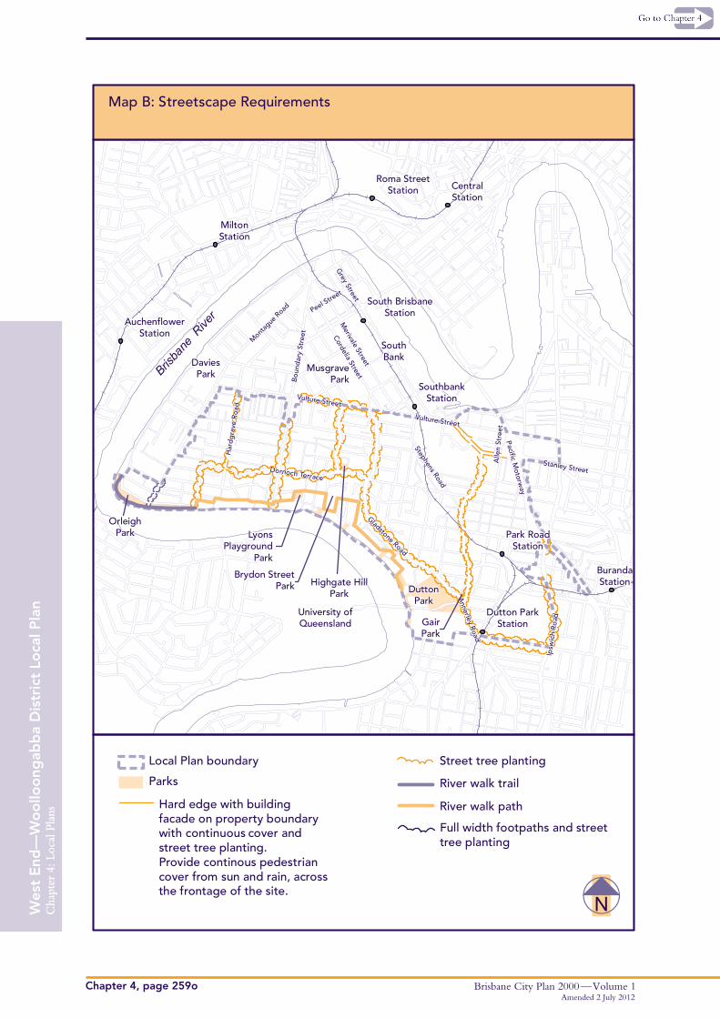
P1 Development must contribute toward streetscape outcomes for key streets
A1.1 Development is in accordance with Map B—Streetscape Requirements
A1.2 Development provides for street tree planting, street furniture, lighting and footpath and kerb treatment to Council approved standard
P2 Pedestrian movement must be improved by providing safe and accessible links to important services and facilities
A2 Pedestrian links are provided in the locations shown on Map B—Streetscape Requirements and are:
• a minimum 6m wide and open to the sky
• shaded by appropriate street trees
• designed to provide safe, convenient and well–lit passage for pedestrians
P3 Development adjacent to the RiverWalk must provide the RiverWalk identified on Map B—Streetscape Requirements
A3.1 RiverWalk is provided including footpath, lighting and shade planting in accordance with Public Riverside Facilities Design and Maintenance Manual
A3.2 Sites with frontages greater than 35m include seating and a drinking fountain in accordance with Public Riverside Facilities Design and Maintenance Manual
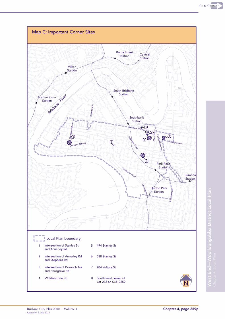
P4 Important corner sites (shown on Map C—Important Corner Sites) must provide landmark definition of the corner through its building form, scale, materials and landscaping
A4 No Acceptable Solution is prescribed
P5 New development adjacent to and/or in the vicinity of a heritage place must maintain and enhance the heritage place and its surrounds by:• the use of high quality pre–finished materials• setting background and/or upper levels to
preserve view lines to the heritage place • ensuring elevation treatments maintain the
three–dimensional predominance of the heritage place
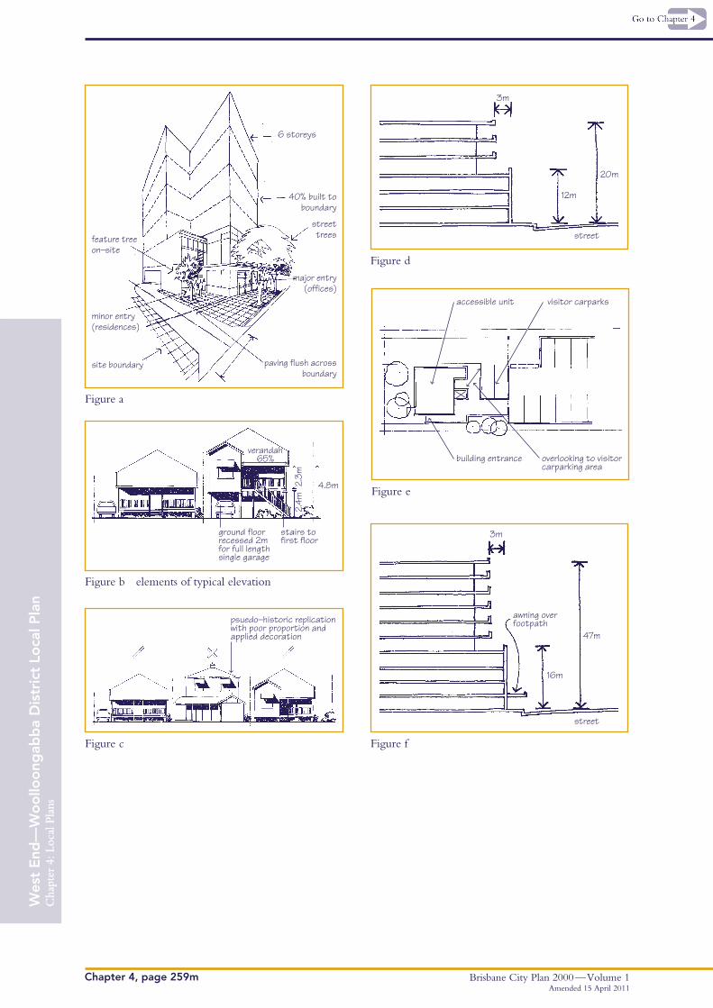
A5 Development complements the scale of, views to and building form and materials of heritage places as shown in Figure a
P6 Protected vegetation must be retained and incorporated into the design/layout of buildings and infrastructure
A6.1 Proposals are to be designed to incorporate and show on a landscape concept plan the significant landscape trees listed in the Natural Assets Planning Scheme Policy
A6.2 Where these significant landscape trees cannot be retained within the development layout, replacement planting is shown on a landscape concept plan and provided as follows:
• advanced stock with a minimum 400 litre pot size, 4m high and,
• are provided with 12 months aftercare
Brisbane City Plan 2000 — Volume 1Amended 15 April 2011
Chapter 4, page 259f
Wes
t E
nd—
Wo
ollo
ong
abb
a D
istr
ict
Loca
l Pla
nC
hapt
er 4
: Loc
al P
lans
Performance Criteria Acceptable Solutions
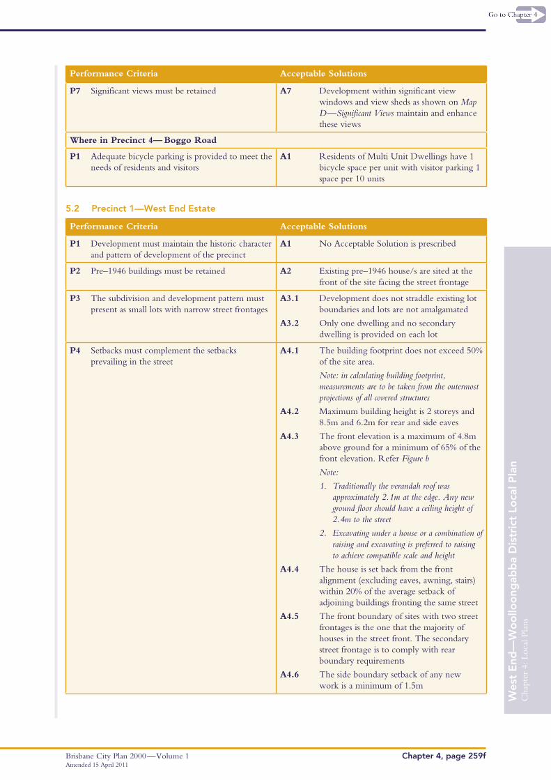
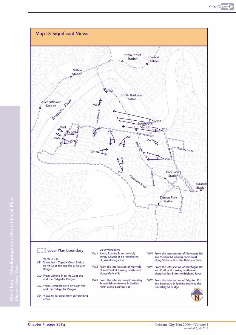
P7 Significant views must be retained A7 Development within significant view windows and view sheds as shown on Map D—Significant Views maintain and enhance these views
Where in Precinct 4— Boggo Road
P1 Adequate bicycle parking is provided to meet the needs of residents and visitors
A1 Residents of Multi Unit Dwellings have 1 bicycle space per unit with visitor parking 1 space per 10 units
5.2 Precinct 1—West End Estate
Performance Criteria Acceptable Solutions
P1 Development must maintain the historic character and pattern of development of the precinct
A1 No Acceptable Solution is prescribed
P2 Pre–1946 buildings must be retained A2 Existing pre–1946 house/s are sited at the front of the site facing the street frontage
P3 The subdivision and development pattern must present as small lots with narrow street frontages
A3.1 Development does not straddle existing lot boundaries and lots are not amalgamated
A3.2 Only one dwelling and no secondary dwelling is provided on each lot
P4 Setbacks must complement the setbacks prevailing in the street
A4.1 The building footprint does not exceed 50% of the site area.
Note: in calculating building footprint, measurements are to be taken from the outermost projections of all covered structures
A4.2 Maximum building height is 2 storeys and 8.5m and 6.2m for rear and side eaves
A4.3 The front elevation is a maximum of 4.8m above ground for a minimum of 65% of the front elevation. Refer Figure b
Note:
1. Traditionally the verandah roof was approximately 2.1m at the edge. Any new ground floor should have a ceiling height of 2.4m to the street
2. Excavating under a house or a combination of raising and excavating is preferred to raising to achieve compatible scale and height
A4.4 The house is set back from the front alignment (excluding eaves, awning, stairs) within 20% of the average setback of adjoining buildings fronting the same street
A4.5 The front boundary of sites with two street frontages is the one that the majority of houses in the street front. The secondary street frontage is to comply with rear boundary requirements
A4.6 The side boundary setback of any new work is a minimum of 1.5m
Cha
pter
4: L
ocal
Pla
ns
Brisbane City Plan 2000 — Volume 1Chapter 4, page 259g
Wes
t E
nd—
Wo
ollo
ong
abb
a D
istr
ict
Loca
l Pla
nC
hapt
er 4
: Loc
al P
lans
Performance Criteria Acceptable Solutions
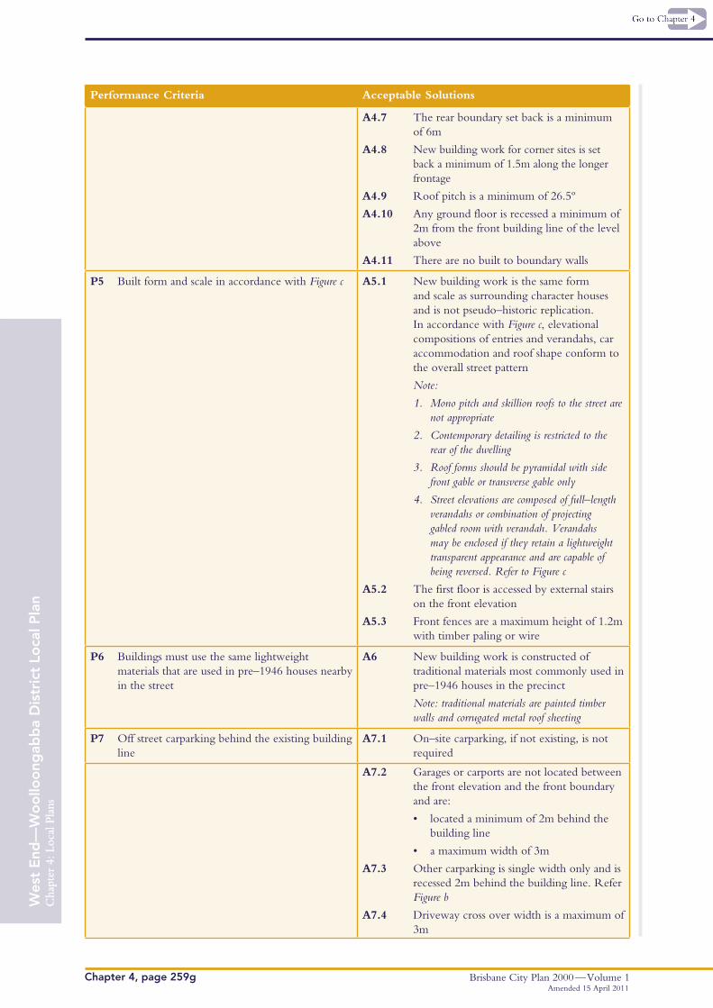
A4.7 The rear boundary set back is a minimum of 6m
A4.8 New building work for corner sites is set back a minimum of 1.5m along the longer frontage
A4.9 Roof pitch is a minimum of 26.5º
A4.10 Any ground floor is recessed a minimum of 2m from the front building line of the level above
A4.11 There are no built to boundary walls
P5 Built form and scale in accordance with Figure c A5.1 New building work is the same form and scale as surrounding character houses and is not pseudo–historic replication. In accordance with Figure c, elevational compositions of entries and verandahs, car accommodation and roof shape conform to the overall street pattern
Note:
1. Mono pitch and skillion roofs to the street are not appropriate
2. Contemporary detailing is restricted to the rear of the dwelling
3. Roof forms should be pyramidal with side front gable or transverse gable only
4. Street elevations are composed of full–length verandahs or combination of projecting gabled room with verandah. Verandahs may be enclosed if they retain a lightweight transparent appearance and are capable of being reversed. Refer to Figure c
A5.2 The first floor is accessed by external stairs on the front elevation
A5.3 Front fences are a maximum height of 1.2m with timber paling or wire
P6 Buildings must use the same lightweight materials that are used in pre–1946 houses nearby in the street
A6 New building work is constructed of traditional materials most commonly used in pre–1946 houses in the precinct
Note: traditional materials are painted timber walls and corrugated metal roof sheeting
P7 Off street carparking behind the existing building line
A7.1 On–site carparking, if not existing, is not required
A7.2 Garages or carports are not located between the front elevation and the front boundary and are:
• located a minimum of 2m behind the building line
• a maximum width of 3m
A7.3 Other carparking is single width only and is recessed 2m behind the building line. Refer Figure b
A7.4 Driveway cross over width is a maximum of 3m
Amended 15 April 2011
Brisbane City Plan 2000 — Volume 1Amended 15 April 2011
Chapter 4, page 259h
Wes
t E
nd—
Wo
ollo
ong
abb
a D
istr
ict
Loca
l Pla
nC
hapt
er 4
: Loc
al P
lans
Performance Criteria Acceptable Solutions
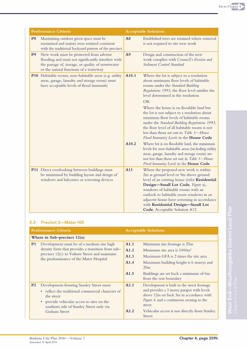
P8 Maximising outdoor green space must be maximised and mature trees retained consistent with the traditional backyard pattern of the precinct
A8 Established trees are retained where removal is not required to site new work
P9 New work must be protected from adverse flooding and must not significantly interfere with the passage of, storage, or quality of stormwater or the natural functions of a waterway
A9 Design and construction of the new work complies with Council’s Erosion and Sediment Control Standard
P10 Habitable rooms, non–habitable areas (e.g. utility areas, garage, laundry and storage room) must have acceptable levels of flood immunity
A10.1 Where the lot is subject to a resolution about minimum floor levels of habitable rooms under the Standard Building Regulations 1993, the floor level satisfies the level determined in the resolution
OR
Where the house is on floodable land but the lot is not subject to a resolution about minimum floor levels of habitable rooms under the Standard Building Regulations 1993, the floor level of all habitable rooms is not less than those set out in Table 1—House Flood Immunity Levels in the House Code
A10.2 Where lot is on floodable land, the minimum levels for non–habitable areas (including utility areas, garage, laundry and storage room) are not less than those set out in Table 1—House Flood Immunity Levels in the House Code
P11 Direct overlooking between buildings must be minimised by building layout and design of windows and balconies or screening devices
A11 Where the proposed new work is within 2m at ground level or 9m above ground level of an existing house (refer Residential Design—Small Lot Code, Figure u), windows of habitable rooms with an outlook to habitable room windows in an adjacent house have screening in accordance with Residential Design—Small Lot Code, Acceptable Solution A12
5.3 Precinct 2—Mater Hill
Performance Criteria Acceptable Solutions
Where in Sub–precinct 12(a)
P1 Development must be of a medium rise high density form that provides a transition from sub–precinct 12(c) to Vulture Street and maintains the predominance of the Mater Hospital
A1.1 Minimum site frontage is 25m
A1.2 Minimum site area is 1000m2
A1.3 Maximum GFA is 2 times the site area
A1.4 Maximum building height is 6 storeys and 20m
A1.5 Buildings are set back a minimum of 6m from the rear boundary
P2 Development fronting Stanley Street must:
• reflect the traditional commercial character of the street
• provide vehicular access to sites on the southern side of Stanley Street only via Graham Street
A2.1 Development is built to the street frontage and provides a 3 storey parapet with levels above 12m set back 3m in accordance with Figure d, and a continuous awning to the street
A2.2 Vehicular access is not directly from Stanley Street

Cha
pter
4: L
ocal
Pla
ns
Brisbane City Plan 2000 — Volume 1Chapter 4, page 259i
Wes
t E
nd—
Wo
ollo
ong
abb
a D
istr
ict
Loca
l Pla
nC
hapt
er 4
: Loc
al P
lans
Performance Criteria Acceptable Solutions
• comprise vehicular access that improves safety and alleviates traffic impacts
• maintain an active street frontage
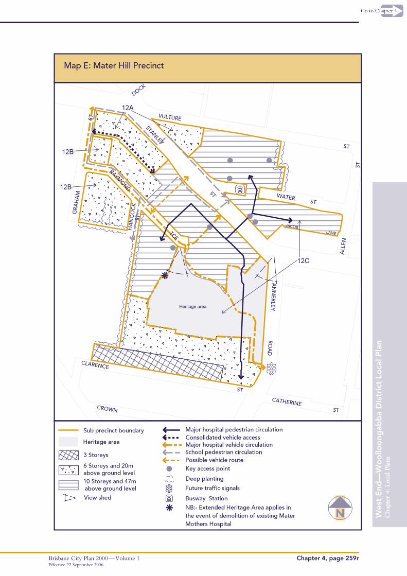
A2.3 Vehicular access is consolidated in accordance with vehicle routes on the Centre Concept Plan Map E—Mater Hill Precinct
A2.4 Vehicle parking including visitor and tenant carparking, refuse collection manoeuvring and refuse storage areas are not visible from the street
A2.5 A retail or commercial use is maintained on the ground storey
A2.6 Development incorporating mixed uses has separate entries within 2m of the front boundary for the residential and non–residential components of the building as shown in Figure a
Where in Sub–precinct 12(b)
P3 Development must be a medium rise medium density residential form with building height limited to minimise overshadowing impacts to adjoining educational users and maintain the predominance of the Mater Hospital
A3.1 Minimum site frontage is 20m
A3.2 Minimum site area is 800m2
A3.3 Maximum GFA is 2 times the site area
A3.4 Maximum building height is 6 storeys and 20m
A3.5 Building setbacks to side boundaries not fronting a street are a minimum of 3m
P4 Multi–unit dwellings must be easily adaptable to the needs of people with disabilities
A4.1 The ground floor of buildings is to include a minimum of one (1) unit that is designed to be adaptable to the requirements of Australian Standard AS4299, Adaptable Housing, Class C and Housing Queensland’s Universal Housing Design. Refer to Figure e
A4.2 All external pathways, entrance foyers and entrances to all units within the development are provided in accordance with Australian Standard AS1428 Design for Access and Mobility
Where in Sub–precinct 12(c)
P5 The siting, scale, appearance and design of development must be respectful of the adjoining schools and residential uses to reduce overshadowing, traffic and servicing impacts
A5.1 Maximum building heights are in accordance with the Centre Concept Plan Map E—Mater Hill Precinct
A5.2 Carparking, servicing and recreational facilities are set back a minimum of 6m from any boundary adjoining a residential use or school external to the sub–precinct and is landscaped with deep planting to provide a visual buffer
A5.3 The building form is staggered to reduce overshadowing of habitable areas or significant open spaces on neighbouring sites
P6 Development adjoining a heritage place, the heritage area or within the heritage area, must respect the heritage setting landscape as defined in the heritage place citation, in terms of building setbacks, heights, materials and design
A6.1 Heritage places in the heritage area and views shown on the Centre Concept Plan Map E—Mater Hill Precinct are maintained and enhanced, consistent with an approved conservation plan
A6.2 Development:
• is contemporary in form and detailing so as to complement the heritage places
• maintains views shown on the Centre Concept Plan Map E—Mater Hill Precinct
Amended 15 April 2011
Brisbane City Plan 2000 — Volume 1Amended 15 April 2011
Chapter 4, page 259j
Wes
t E
nd—
Wo
ollo
ong
abb
a D
istr
ict
Loca
l Pla
nC
hapt
er 4
: Loc
al P
lans
Performance Criteria Acceptable Solutions
• provides a suitable transition to the scale, materials and height of the heritage places and protects significant vegetation
• minimises overshadowing of the heritage places
A6.3 Development along Annerley Road:
• maintains the stairs as an important access to hospital facilities
• is set back from Annerley Road to the building line of the 1931 Mater Children’s Hospital
• ensures that vehicular access does not impact on the wall or stairs
A6.4 Any development of the former Mater Children’s Hospital maintains the building footprint and building scale which is symmetrical with the location of the stairs from Annerley Road
P7 The building design and materials must be of a high quality to respond to the importance of the building as a major health facility that is highly visible from a number of key transport routes and the surrounding area
A7.1 Development built to the Stanley Street frontage provides a continuous awning to the street and a four storey parapet with levels above 16m set back 3m in accordance with Figure f
A7.2 Elevations are articulated using colour, texture, materials (including face brick), setbacks and architectural features to reduce visual bulk and complement the heritage place in the precinct
A7.3 Roof shapes, parapets and overall building forms add to the visual distinction of the hospital, including when viewed from a distance
A7.4 Vehicle parking including visitor and tenant carparking, refuse collection, manoeuvring and refuse storage areas are not visible from the street
P8 Pedestrian paths must be easily identifiable and well planned to connect important nodes of the hospital with surrounding services and facilities, such as the Busway
A8.1 Key access points as shown on the Centre Concept Plan Map E—Mater Hill Precinct are enhanced through any development
A8.2 Development provides safe, legible and accessible pedestrian circulation between hospital facilities, street level, drop–off zones, carparks and public transport in accordance with the Crime Prevention Through Environment Design (CPTED) Planning Scheme Policy
P9 Major traffic generating uses must have vehicular access to the surrounding major roads to minimise traffic impacts on nearby residential streets
A9.1 Major traffic generating uses are located north of the heritage area and fronting Stanley Street and have consolidated access to Stanley Street, Vulture Street, or Raymond Terrace
A9.2 Access to Annerley Road is safe and efficient
A9.3 No vehicular access to and from major traffic generating uses in the hospital is provided via Clarence Street
Cha
pter
4: L
ocal
Pla
ns
Brisbane City Plan 2000 — Volume 1Chapter 4, page 259k
Wes
t E
nd—
Wo
ollo
ong
abb
a D
istr
ict
Loca
l Pla
nC
hapt
er 4
: Loc
al P
lans
Amended 15 April 2011
Performance Criteria Acceptable Solutions
P10 Development of the hospital must minimise impacts to residential uses fronting Clarence Street
A10 Development:
• provides a landscaped setback of a minimum of 6m from the street frontage
• is a maximum of 3 storeys in height for a depth of 20m
• incorporates design elements and materials that are in character with the residential uses fronting Clarence Street
• minimises overshadowing of habitable rooms in residential buildings on the southern side of Clarence Street
• does not include direct access to Clarence Street
P11 Development built over roads must:
• provide for safe vehicular traffic movements• provide for pedestrian safety• create a high quality streetscape amenity in
terms of building form and detailing, lighting, materials and landscaping
• be designed to minimise the visual bulk and scale of the structure
• maximise solar access to the street
A11 Development over Stanley Street:
• is for pedestrian and service access only
• has a minimum 80% transparency
• has clearance to allow the continued safe use of the road by all vehicles
• limits the width of the building over the road
• provides lightwells at a maximum spacing of every 8m
• provides high quality cladding and sculptural treatments to the underside of buildings located over roads
• provides pedestrian lighting for both daytime and night–time use
• provides for street tree planting, street furniture, lighting and footpath and kerb treatment to Council approved standard
5.4 Precinct 3—Transit Oriented
Performance Criteria Acceptable Solutions
P1 Development must be well planned and provide:
• a mixture of residential and commercial uses• a landmark design• safe and convenient connections and access to
surrounding services and facilities
A1 Development is in accordance with an approved Structure Plan which provides:
• a useable and attractive public space
• development over the Woolloongabba Busway Station layover area
• a landmark building form which addresses the high visibility of the site from the South–East Freeway, Ipswich Road and Vulture Street
• convenience retail uses that reinforce the centre activities along Stanley Street
• high density residential uses with a site layout and design that address amenity issues from the major sporting and transport facilities and road networks
Brisbane City Plan 2000 — Volume 1 Chapter 4, page 259l
Wes
t E
nd—
Wo
ollo
ong
abb
a D
istr
ict
Loca
l Pla
nC
hapt
er 4
: Loc
al P
lans
Amended 15 April 2011
• improved pedestrian and cycle connections to the Woolloongabba Centre East, Brisbane Cricket Ground and Busway Station
• low cost housing
5.5 Precinct 4—Boggo Road
Performance Criteria Acceptable Solutions
P1 Development must be of a medium density form, which:
• complements the character of the locality• provides integrated transport solutions• provides accessible parkland• avoids increased traffic volumes in adjacent
residential streets
A1 Development is in accordance with an approved Structure Plan that:
• provides a maximum of a medium rise form
• maintains the setting of heritage places in accordance with an approved conservation plan
• contains high quality public parkland and community facilities that are easily accessible for residents living in and around the precinct
• creates a safe pedestrian environment to facilitate easy pedestrian and cyclist access to, through and within the precinct, in accordance with the Crime Prevention Through Environment Design (CPTED) Planning Scheme Policy
• maximises access to and use of local public transport nodes and parks
• provides vehicle access to the site only from Annerley Road
Cha
pter
4: L
ocal
Pla
ns
Brisbane City Plan 2000 — Volume 1Chapter 4, page 259m
Wes
t E
nd—
Wo
ollo
ong
abb
a D
istr
ict
Loca
l Pla
nC
hapt
er 4
: Loc
al P
lans
Amended 15 April 2011
Figure b elements of typical elevation
ground floor recessed 2m for full length single garage
stairs to first floor
2.3m
2.4m
4.8m
verandah 65%
Figure c
psuedo–historic replication with poor proportion and applied decoration
6 storeys
40% built to boundary
street trees
major entry (offices)
paving flush across boundary
minor entry (residences)
feature tree on–site
Figure a
site boundary
Figure d
3m
12m
20m
street
Figure f
street
47m
16m
3m
awning over footpath
Figure e
accessible unit visitor carparks
building entrance overlooking to visitor carparking area
Brisbane City Plan 2000 — Volume 1Amended 2 July 2012
Chapter 4, page 259n
Wes
t E
nd—
Wo
ollo
ong
abb
a D
istr
ict
Loca
l Pla
nC
hapt
er 4
: Loc
al P
lans
5
2c
1
4
3
2a2b
Gladstone Road
Pacific Motorw
ay
Vulture Street
Annerley Road
Merivale Street
Mont
ague
Road
Dornoch Terrace
Cordelia Street
Bou
ndar
y St
reet
Stephens Road
Grey Street
Har
dg
rave
Roa
d
Peel Street
Ipsw
ich
Ro
ad
Stanley Street
Alle
n St
reet
Vulture Street
MiltonStation
BurandaStation
CentralStation
Park RoadStation
SouthbankStation
Dutton ParkStation
Roma StreetStation
AuchenflowerStation
South BrisbaneStation
Map A: Precincts
³³çN(
Brisba
ne R
iver
Local Plan boundary
Precinct boundary
1 West End Estate Precinct2 Mater Hill Precinct3 Transit Orientated Precinct4 Boggo Road Precinct5 Princess Alexandra Hosiptal Precinct
Cha
pter
4: L
ocal
Pla
ns
Brisbane City Plan 2000 — Volume 1Chapter 4, page 259o
Wes
t E
nd—
Wo
ollo
ong
abb
a D
istr
ict
Loca
l Pla
nC
hapt
er 4
: Loc
al P
lans
Gladstone Road
Pacific Motorw
ay
Vulture Street
Annerley Road
Merivale Street
Mont
ague
Road
Dornoch Terrace
Cordelia Street
Bou
ndar
y St
reet
Stephens Road
Grey Street
Har
dg
rave
Roa
d
Peel Street
Ipsw
ich
Ro
ad
Stanley Street
Alle
n St
reet
Vulture Street
MiltonStation
BurandaStation
CentralStation
Park RoadStation
SouthbankStation
Dutton ParkStation
Roma StreetStation
AuchenflowerStation
South BrisbaneStation
Map B: Streetscape Requirements
³³çN(
Brisba
ne R
iver
Local Plan boundary
Parks
Hard edge with buildingfacade on property boundarywith continuous cover andstreet tree planting. Provide continous pedestriancover from sun and rain, acrossthe frontage of the site.
DaviesPark
OrleighPark Lyons
PlaygroundPark
Brydon StreetPark Highgate Hill
Park
SouthBank
GairPark
DuttonPark
University ofQueensland
MusgravePark
Street tree planting
River walk trail
River walk path
Full width footpaths and streettree planting
Amended 2 July 2012
Brisbane City Plan 2000 — Volume 1 Chapter 4, page 259p
Wes
t E
nd—
Wo
ollo
ong
abb
a D
istr
ict
Loca
l Pla
nC
hapt
er 4
: Loc
al P
lans
Amended 2 July 2012
Pacific Motorw
ay
Annerley Road
Stanley Street
Stephens Road
Vulture Street
Gladstone Road
Bou
ndar
y St
Har
dg
rave
Roa
d
Ipsw
ich
Ro
ad
Dornoch Terrace
Alle
n St
reet
MiltonStation
BurandaStation
CentralStation
Park RoadStation
SouthbankStation
Dutton ParkStation
Roma StreetStation
AuchenflowerStation
South BrisbaneStation
Map C: Important Corner Sites
³³çN(
Brisba
ne R
iver
Local Plan boundary
2
14
6
7
5
3 8
Intersection of Stanley Stand Annerley Rd
Intersection of Annerley Rdand Stephens Rd
Intersection of Dornoch Tceand Hardgrave Rd
99 Gladstone Rd
494 Stanley St
538 Stanley St
204 Vulture St
South west corner ofLot 272 on SL810259
1
2
3
4
5
6
7
8
Cha
pter
4: L
ocal
Pla
ns
Brisbane City Plan 2000 — Volume 1Chapter 4, page 259q
Wes
t E
nd—
Wo
ollo
ong
abb
a D
istr
ict
Loca
l Pla
nC
hapt
er 4
: Loc
al P
lans
Pacific Mo
torway
Annerley R
oad
Stanley Street
Stephens Road
Vulture Street
Gladstone Road
Bou
ndar
y St
Har
dg
rave
Roa
d
Ipsw
ich
Roa
d
MiltonStation
BurandaStation
CentralStation
Park RoadStation
SouthbankStation
Dutton ParkStation
Roma StreetStation
AuchenflowerStation
South BrisbaneStation
Map D: Significant Views
³³çN(
Brisba
ne R
iver
Local Plan boundary
VIEW SHEDViews from Captain Cook Bridgeto Mt Coot-tha and the D’AguilarRanges
From Victoria St to Mt Coot-thaand the D’Aguilar Ranges
From Archibald St to Mt Coot-thaand the D’Arguilar Ranges
Views to Torbreck from surroundingareas
VIEW WINDOWAlong Stanley St to the HolyTrinity Church at 68 HawthorneSt, Woolloongabba
From the intersection of MerivaleSt and Peel St looking north-westalong Merival St
From the intersection of BoundarySt and Edmondstone St lookingnorth along Boundary St
From the intersection of Montague Rdand Victoria St looking north-westalong Victoria St to the Brisbane River
From the intersection of Montague Rdand Kurilpa St looking north-westalong Kurilpa St to the Brisbane River
From the intersection of Brighton Rdand Boundary St looking south to theBoundary St bridge
VS1
VS2
VS3
VS4
VW1
VW2
VW3
VW4
VW5
VW6
VS1
VS2
VS3
VS4
VW1
VW2
VW3
VW4
VW5
VW6 VS1
VS4
VS4
VS4
VS4
Amended 2 July 2012
Cha
pter
4: L
ocal
Pla
ns
Brisbane City Plan 2000 — Volume 1Effective 22 September 2006
Chapter 4, page 259r
Wes
t E
nd—
Wo
ollo
ong
abb
a D
istr
ict
Loca
l Pla
nC
hapt
er 4
: Loc
al P
lans