Embed Size (px)
Citation preview
<<<<
<<<<
<<<< <<<<
<<<<<<
<< <<<<
<<<<
<<<<<<<<<<<<
<<<<
<<<<
<<<<
<<<<<<<<
<<<<
<<<<<<<<
<<<<
<<<<
<<<<
<<<<
<<<<
<<<<
<<<<
<<<<
<<<<
<<<<
<<<<<<<<
<<<<
<<<<
<<<< <<<< <<<<
<<<<
<<<<
<<<<<<<<
<<<<
<<<<
<<<<
<<<<
<<<<
<<<<
<<<<
<<<<
<<<<
<<<<
<<<<
<<<<
<<<<
<<<<
<<<<
<<<<
<<<<
<<<<
<<<<
<<<<
<<<<
<<<<
<<<<<<<<
<<<<
<<<<
<<<<
Bar-SPlayground
1
White CenterTransit HubRoutes: 22, 23, 54, 60, 113, 120, 125, 128, 133, 560
60
60
60
loop
loop
loop
only
loop
loop
loop
only
only
only
only
only
only
only
775
775
775
775
775
775
773
773
773
775
KilbournePark
<<<<
Don ArmeniBoat Ramp
BelvederePark
FairmountPlayground
ErcoliniPark
Highland ParkPlayground
SolsticePark
Colman Pool
CaliforniaPlace Park
South Seattle Community College
Arboretum
MyrtleReservoir
Park
Camp Long
Schmitz Park
FauntleroyCenter
Log HouseMuseum
Cormorant Cove
Longhouse Museum
HighpointLibrary
Schmitz Park Elementary
Madison Middle School
GatewoodElementary
Pathfinder K-8
ADMIRAL
ALKI
GENESEE
ALA
SKA
JUNCTIO
N
MO
RG
AN
JU
NC
TIO
N
FAUNTLEROY
FAUNTLEE HILLS
ARBOR HEIGHTS
HIGH POINT
RIVERVIEW
HARBOR ISLAND
SOUTH PARK
HIGHLAND PARK
WHITE CENTER
WESTWOOD
PU
GE
T R
IDG
E
PIGEON POINT
DE
LR
IDG
E
FA
IRM
OU
NT
SEAVIEW
High Point Playfieldand Community Center
Around the White Center Triangle
Roxbury Clinic
White Center CDADep. Social andHealth Services
Around the GreenBridge Plaza
Greenbridge Library
Boys and Girls Club
YWCA Learning Center
Neighborhood House
Hiawatha Playfield
Hiawatha Community CenterNorthern Red Oak
Alki Playgroundand Beach Park
Statue of Liberty
Alki Community Center
Delridge Playfield
DelridgeCommunity CenterYoungstown CulturalArts Center
Around Camp Long
West Seattle Stadium
Camp LongEducation Center
West SeattleGolf CourseClimbing Rock
Around the SW Community Center
DennyWellness CenterSW Community Center
Sealth TeenHealth Center
SW Swimming Pool
Rt. 60 continues to 14th Ave S. then loops back.
to the “Little Bridge”
Elliot Bay Water Taxi
(West Seattle
toDowntown)
Vashon Ferry Route
W e s t S e a t t l e Tr a i l s
Created By:
Sponsored By:
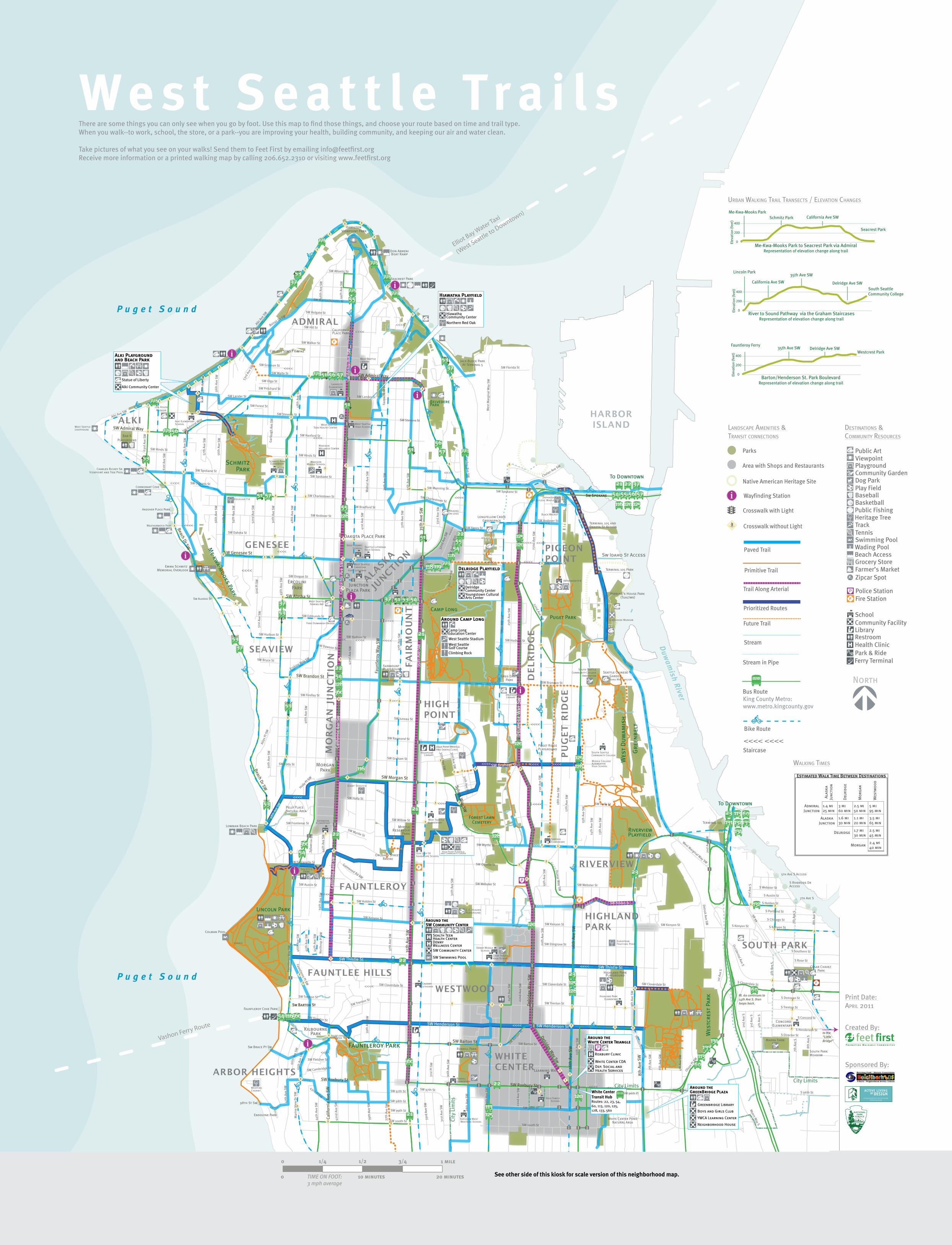
Walking Times
DesTinaTions &CommuniTy ResouRCes
lanDsCape ameniTies & TRansiT ConneCTions
uRban Walking TRail TRanseCTs / elevaTion Changes
Print Date: apRil 2011
<<<< <<<<
Viewpoint
Tennis
BasketballBaseballPlay Field
Track
PlaygroundCommunity Garden
Public Art
Swimming Pool
Grocery Store
Dog Park
Restroom
School
Health Clinic
LibraryCommunity Facility
Fire Station
Park & Ride
Police Station
Public Fishing
Farmer’s Market
Wading PoolBeach Access
Heritage Tree
Ferry Terminal
Zipcar Spot
King County Metro:www.metro.kingcounty.gov
There are some things you can only see when you go by foot. Use this map to find those things, and choose your route based on time and trail type. When you walk--to work, school, the store, or a park--you are improving your health, building community, and keeping our air and water clean.
Take pictures of what you see on your walks! Send them to Feet First by emailing [email protected] Receive more information or a printed walking map by calling 206.652.2310 or visiting www.feetfirst.org
See other side of this kiosk for scale version of this neighborhood map.
P r o m ot i n g W a l k a b l e Com m u n i t i e s
Neighborhoods on Foot M a p S e r i e s
West Seattle
Trails
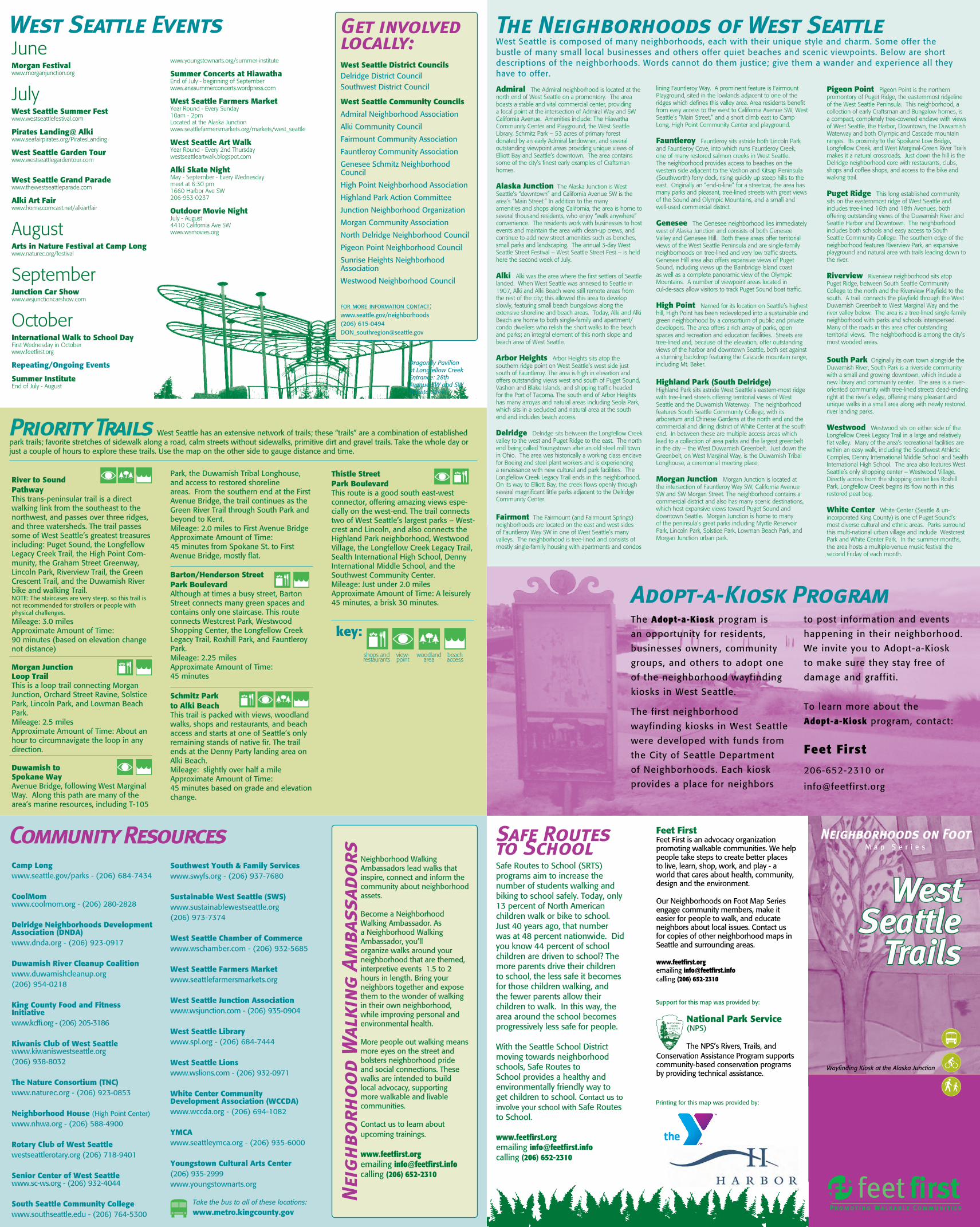
Wayfinding Kiosk at the Alaska Junction
River to Sound PathwayThis trans-peninsular trail is a direct walking link from the southeast to the northwest, and passes over three ridges, and three watersheds. The trail passes some of West Seattle’s greatest treasures including: Puget Sound, the Longfellow Legacy Creek Trail, the High Point Com-munity, the Graham Street Greenway, Lincoln Park, Riverview Trail, the Green Crescent Trail, and the Duwamish River bike and walking Trail. NOTE: The staircases are very steep, so this trail is not recommended for strollers or people with physical challenges. Mileage: 3.0 miles Approximate Amount of Time: 90 minutes (based on elevation change not distance)
Morgan Junction Loop TrailThis is a loop trail connecting Morgan Junction, Orchard Street Ravine, Solstice Park, Lincoln Park, and Lowman Beach Park. Mileage: 2.5 miles Approximate Amount of Time: About an hour to circumnavigate the loop in any direction.
Duwamish to Spokane WayAvenue Bridge, following West Marginal Way. Along this path are many of the area’s marine resources, including T-105
Safe Routes to School (SRTS) programs aim to increase the number of students walking and biking to school safely. Today, only 13 percent of North American children walk or bike to school. Just 40 years ago, that number was at 48 percent nationwide. Did you know 44 percent of school children are driven to school? The more parents drive their children to school, the less safe it becomes for those children walking, and the fewer parents allow their children to walk. In this way, the area around the school becomes progressively less safe for people.
With the Seattle School District moving towards neighborhood schools, Safe Routes to School provides a healthy and environmentally friendly way to get children to school. Contact us to involve your school with Safe Routes to School.
www.feetfirst.orgemailing [email protected] (206) 652-2310
Park, the Duwamish Tribal Longhouse, and access to restored shoreline areas. From the southern end at the First Avenue Bridge, the trail continues as the Green River Trail through South Park and beyond to Kent.Mileage: 2.0 miles to First Avenue BridgeApproximate Amount of Time: 45 minutes from Spokane St. to First Avenue Bridge, mostly flat.
Barton/Henderson Street Park BoulevardAlthough at times a busy street, Barton Street connects many green spaces and contains only one staircase. This route connects Westcrest Park, Westwood Shopping Center, the Longfellow Creek Legacy Trail, Roxhill Park, and Fauntleroy Park.Mileage: 2.25 miles Approximate Amount of Time: 45 minutes
Schmitz Park to Alki BeachThis trail is packed with views, woodland walks, shops and restaurants, and beach access and starts at one of Seattle’s only remaining stands of native fir. The trail ends at the Denny Party landing area on Alki Beach.Mileage: slightly over half a mile Approximate Amount of Time: 45 minutes based on grade and elevation change.
Thistle Street Park BoulevardThis route is a good south east-west connector, offering amazing views espe-cially on the west-end. The trail connects two of West Seattle’s largest parks – West-crest and Lincoln, and also connects the Highland Park neighborhood, Westwood Village, the Longfellow Creek Legacy Trail, Sealth International High School, Denny International Middle School, and the Southwest Community Center.Mileage: Just under 2.0 miles Approximate Amount of Time: A leisurely 45 minutes, a brisk 30 minutes.
key:
Support for this map was provided by:
Get involved locally:West Seattle District CouncilsDelridge District CouncilSouthwest District Council
West Seattle Community Councils
Admiral Neighborhood Association
Alki Community Council
Fairmount Community Association
Fauntleroy Community Association
Genesee Schmitz Neighborhood Council
High Point Neighborhood Association
Highland Park Action Committee
Junction Neighborhood Organization
Morgan Community Association
North Delridge Neighborhood Council
Pigeon Point Neighborhood Council
Sunrise Heights Neighborhood Association
Westwood Neighborhood Council
for more information contact:www.seattle.gov/neighborhoods(206) [email protected]
Dragonfly Pavilion at Longfellow Creek Entrance: 28th Avenue SW and SW Dakota Street
Priority Trails West Seattle has an extensive network of trails; these “trails” are a combination of established park trails; favorite stretches of sidewalk along a road, calm streets without sidewalks, primitive dirt and gravel trails. Take the whole day or just a couple of hours to explore these trails. Use the map on the other side to gauge distance and time.
Neighborhood Walking Ambassadors lead walks that inspire, connect and inform the community about neighborhood assets.
Become a Neighborhood Walking Ambassador. As a Neighborhood Walking Ambassador, you’ll organize walks around your neighborhood that are themed, interpretive events 1.5 to 2 hours in length. Bring your neighbors together and expose them to the wonder of walking in their own neighborhood, while improving personal and environmental health.
More people out walking means more eyes on the street and bolsters neighborhood pride and social connections. These walks are intended to build local advocacy, supporting more walkable and livable communities.
Contact us to learn about upcoming trainings.
www.feetfirst.orgemailing [email protected] (206) 652-2310
The Adopt-a-Kiosk program is
an opportunity for residents,
businesses owners, community
groups, and others to adopt one
of the neighborhood wayfinding
kiosks in West Seattle.
The first neighborhood
wayfinding kiosks in West Seattle
were developed with funds from
the City of Seattle Department
of Neighborhoods. Each kiosk
provides a place for neighbors
to post information and events
happening in their neighborhood.
We invite you to Adopt-a-Kiosk
to make sure they stay free of
damage and graffiti.
To learn more about the
Adopt-a-Kiosk program, contact:
Feet First
206-652-2310 or
National Park Service (NPS)
The NPS’s Rivers, Trails, and Conservation Assistance Program supports community-based conservation programs by providing technical assistance.
Feet FirstFeet First is an advocacy organization promoting walkable communities. We help people take steps to create better places to live, learn, shop, work, and play - a world that cares about health, community, design and the environment.
Our Neighborhoods on Foot Map Series engage community members, make it easier for people to walk, and educate neighbors about local issues. Contact us for copies of other neighborhood maps in Seattle and surrounding areas.
www.feetfirst.orgemailing [email protected] (206) 652-2310
June Morgan Festival www.morganjunction.org
JulyWest Seattle Summer Festwww.westseattlefestival.com Pirates Landing@ Alkiwww.seafairpirates.org/PiratesLanding
West Seattle Garden Tourwww.westseattlegardentour.com
West Seattle Grand Paradewww.thewestseattleparade.com
Alki Art Fairwww.home.comcast.net/alkiartfair
AugustArts in Nature Festival at Camp Longwww.naturec.org/festival
SeptemberJunction Car Showwww.wsjunctioncarshow.com
OctoberInternational Walk to School DayFirst Wednesday in Octoberwww.feetfirst.org
Repeating/Ongoing Events
Summer InstituteEnd of July - August
www.youngstownarts.org/summer-institute
Summer Concerts at HiawathaEnd of July - beginning of Septemberwww.anasummerconcerts.wordpress.com
West Seattle Farmers Market Year Round - Every Sunday10am - 2pmLocated at the Alaska Junctionwww.seattlefarmersmarkets.org/markets/west_seattle
West Seattle Art Walk Year Round - Every 2nd Thursdaywestseattleartwalk.blogspot.com
Alki Skate Night May - September - Every Wednesdaymeet at 6:30 pm 1660 Harbor Ave SW206-953-0237
Outdoor Movie Night July - August4410 California Ave SWwww.wsmovies.org
Printing for this map was provided by:
Camp Longwww.seattle.gov/parks - (206) 684-7434
CoolMom www.coolmom.org - (206) 280-2828
Delridge Neighborhoods Development Association (DNDA)www.dnda.org - (206) 923-0917
Duwamish River Cleanup Coalitionwww.duwamishcleanup.org (206) 954-0218
King County Food and Fitness Initiative www.kcffi.org - (206) 205-3186
Kiwanis Club of West Seattle www.kiwaniswestseattle.org(206) 938-8032
The Nature Consortium (TNC)www.naturec.org - (206) 923-0853
Neighborhood House (High Point Center)www.nhwa.org - (206) 588-4900
Rotary Club of West Seattlewestseattlerotary.org (206) 718-9401
Senior Center of West Seattle www.sc-ws.org - (206) 932-4044
South Seattle Community Collegewww.southseattle.edu - (206) 764-5300
Admiral The Admiral neighborhood is located at the north end of West Seattle on a promontory. The area boasts a stable and vital commercial center, providing a focal point at the intersection of Admiral Way and SW California Avenue. Amenities include: The Hiawatha Community Center and Playground, the West Seattle Library, Schmitz Park – 53 acres of primary forest donated by an early Admiral landowner, and several outstanding viewpoint areas providing unique views of Elliott Bay and Seattle’s downtown. The area contains some of the city’s finest early examples of Craftsman homes.
Alaska Junction The Alaska Junction is West Seattle’s “downtown” and California Avenue SW is the area’s “Main Street.” In addition to the many amenities and shops along California, the area is home to several thousand residents, who enjoy “walk anywhere” convenience. The residents work with businesses to host events and maintain the area with clean-up crews, and continue to add new street amenities such as benches, small parks and landscaping. The annual 3-day West Seattle Street Festival – West Seattle Street Fest – is held here the second week of July.
Alki Alki was the area where the first settlers of Seattle landed. When West Seattle was annexed to Seattle in 1907, Alki and Alki Beach were still remote areas from the rest of the city; this allowed this area to develop slowly, featuring small beach bungalows along the extensive shoreline and beach areas. Today, Alki and Alki Beach are home to both single-family and apartment/condo dwellers who relish the short walks to the beach and parks; an integral element of this north slope and beach area of West Seattle.
Arbor Heights Arbor Heights sits atop the southern ridge point on West Seattle’s west side just south of Fauntleroy. The area is high in elevation and offers outstanding views west and south of Puget Sound, Vashon and Blake Islands, and shipping traffic headed for the Port of Tacoma. The south end of Arbor Heights has many arroyas and natural areas including Seola Park, which sits in a secluded and natural area at the south end and includes beach access.
Delridge Delridge sits between the Longfellow Creek valley to the west and Puget Ridge to the east. The north end being called Youngstown after an old steel mill town in Ohio. The area was historically a working class enclave for Boeing and steel plant workers and is experiencing a renaissance with new cultural and park facilities. The Longfellow Creek Legacy Trail ends in this neighborhood. On its way to Elliott Bay, the creek flows openly through several magnificent little parks adjacent to the Delridge Community Center.
Fairmont The Fairmount (and Fairmount Springs) neighborhoods are located on the east and west sides of Fauntleroy Way SW in one of West Seattle’s many valleys. The neighborhood is tree-lined and consists of mostly single-family housing with apartments and condos
Southwest Youth & Family Serviceswww.swyfs.org - (206) 937-7680
Sustainable West Seattle (SWS)www.sustainablewestseattle.org(206) 973-7374
West Seattle Chamber of Commercewww.wschamber.com - (206) 932-5685
West Seattle Farmers Marketwww.seattlefarmersmarkets.org
West Seattle Junction Associationwww.wsjunction.com - (206) 935-0904
West Seattle Librarywww.spl.org - (206) 684-7444
West Seattle Lionswww.wslions.com - (206) 932-0971
White Center Community Development Association (WCCDA)www.wccda.org - (206) 694-1082
YMCAwww.seattleymca.org - (206) 935-6000
Youngstown Cultural Arts Center(206) 935-2999www.youngstownarts.org
lining Fauntleroy Way. A prominent feature is Fairmount Playground, sited in the lowlands adjacent to one of the ridges which defines this valley area. Area residents benefit from easy access to the west to California Avenue SW, West Seattle’s “Main Street,” and a short climb east to Camp Long, High Point Community Center and playground.
Fauntleroy Fauntleroy sits astride both Lincoln Park and Fauntleroy Cove, into which runs Fauntleroy Creek, one of many restored salmon creeks in West Seattle. The neighborhood provides access to beaches on the western side adjacent to the Vashon and Kitsap Peninsula (Southworth) ferry dock, rising quickly up steep hills to the east. Originally an “end-o-line” for a streetcar, the area has many parks and pleasant, tree-lined streets with great views of the Sound and Olympic Mountains, and a small and well-used commercial district.
Genesee The Genesee neighborhood lies immediately west of Alaska Junction and consists of both Genesee Valley and Genesee Hill. Both these areas offer territorial views of the West Seattle Peninsula and are single-family neighborhoods on tree-lined and very low traffic streets. Genesee Hill area also offers expansive views of Puget Sound, including views up the Bainbridge Island coast as well as a complete panoramic view of the Olympic Mountains. A number of viewpoint areas located in cul-de-sacs allow visitors to track Puget Sound boat traffic.
High Point Named for its location on Seattle’s highest hill, High Point has been redeveloped into a sustainable and green neighborhood by a consortium of public and private developers. The area offers a rich array of parks, open spaces and recreation and education facilities. Streets are tree-lined and, because of the elevation, offer outstanding views of the harbor and downtown Seattle, both set against a stunning backdrop featuring the Cascade mountain range, including Mt. Baker.
Highland Park (South Delridge)Highland Park sits astride West Seattle’s eastern-most ridge with tree-lined streets offering territorial views of West Seattle and the Duwamish Waterway. The neighborhood features South Seattle Community College, with its arboretum and Chinese Gardens at the north end and the commercial and dining district of White Center at the south end. In between these are multiple access areas which lead to a collection of area parks and the largest greenbelt in the city – the West Duwamish Greenbelt. Just down the Greenbelt, on West Marginal Way, is the Duwamish Tribal Longhouse, a ceremonial meeting place.
Morgan Junction Morgan Junction is located at the intersection of Fauntleroy Way SW, California Avenue SW and SW Morgan Street. The neighborhood contains a commercial district and also has many scenic destinations, which host expansive views toward Puget Sound and downtown Seattle. Morgan Junction is home to many of the peninsula’s great parks including Myrtle Reservoir Park, Lincoln Park, Solstice Park, Lowman Beach Park, and Morgan Junction urban park.
Pigeon Point Pigeon Point is the northern promontory of Puget Ridge, the easternmost ridgeline of the West Seattle Peninsula. This neighborhood, a collection of early Craftsman and Bungalow homes, is a compact, completely tree-covered enclave with views of West Seattle, the Harbor, Downtown, the Duwamish Waterway and both Olympic and Cascade mountain ranges. Its proximity to the Spoikane Low Bridge, Longfellow Creek, and West Marginal-Green River Trails makes it a natural crossroads. Just down the hill is the Delridge neighborhood core with restaurants, clubs, shops and coffee shops, and access to the bike and walking trail.
Puget Ridge This long established community sits on the easternmost ridge of West Seattle and includes tree-lined 16th and 18th Avenues, both offering outstanding views of the Duwamish River and Seattle Harbor and Downtown. The neighborhood includes both schools and easy access to South Seattle Community College. The southern edge of the neighborhood features Riverview Park, an expansive playground and natural area with trails leading down to the river.
Riverview Riverview neighborhood sits atop Puget Ridge, between South Seattle Community College to the north and the Riverview Playfield to the south. A trail connects the playfield through the West Duwamish Greenbelt to West Marginal Way and the river valley below. The area is a tree-lined single-family neighborhood with parks and schools interspersed. Many of the roads in this area offer outstanding territorial views. The neighborhood is among the city’s most wooded areas.
South Park Originally its own town alongside the Duwamish River, South Park is a riverside community with a small and growing downtown, which include a new library and community center. The area is a river-oriented community with tree-lined streets dead-ending right at the river’s edge, offering many pleasant and unique walks in a small area along with newly restored river landing parks.
Westwood Westwood sits on either side of the Longfellow Creek Legacy Trail in a large and relatively flat valley. Many of the area’s recreational facilities are within an easy walk, including the Southwest Athletic Complex, Denny International Middle School and Sealth International High School. The area also features West Seattle’s only shopping center – Westwood Village. Directly across from the shopping center lies Roxhill Park, Longfellow Creek begins its flow north in this restored peat bog.
White Center White Center (Seattle & un-incorporated King County) is one of Puget Sound’s most diverse cultural and ethnic areas. Parks surround this multi-national urban village and include Westcrest Park and White Center Park. In the summer months, the area hosts a multiple-venue music festival the second Friday of each month.
West Seattle is composed of many neighborhoods, each with their unique style and charm. Some offer the bustle of many small local businesses and others offer quiet beaches and scenic viewpoints. Below are short descriptions of the neighborhoods. Words cannot do them justice; give them a wander and experience all they have to offer.
Community Resources Safe Routes to School
Adopt-a-Kiosk Program
Nei
gh
borh
oo
d W
alki
ng A
mba
ssad
ors
The Neighborhoods of West SeattleWest Seattle Events
shops and restaurants
view-point
woodland area
beach access
Take the bus to all of these locations:
www.metro.kingcounty.gov