Embed Size (px)
Citation preview
West Virginia Historical Society
Volume XXIV, No. 1, SPRING 2010
Visit us on the web at www.wvculture.org/history/wvhssoc
By
William B. Maxwell, Esq.
(Mr. Maxwell has an undergraduate degree from Harvard and his law degree [J.D.] from West Virginia University School of Law. He was a partner at Spilman, Thomas, Battle and Klostermeyer where he headed the real property department. From 1963 until 1980, he was Deputy Commissioner of Forfeited and Delinquent Lands for Kanawha County)
The Crown patents of lands in the Kanawha valley –those executed by the earl of Dunmore on behalf of George III, have their origin in the aggressive policies of the lieutenant governor of Virginia, Robert Dinwiddie(1), who was appointed to his office under George II in 1751 and served until 1758 when he returned to England.
Dinwiddie was the son of a Scottish merchant from Glasgow and first came to America in 1718 as a young man, settling in Bermuda where he acted as customs collector. Dinwiddie was among many Scots who were to take advantage of the
1 Encyclopedia of Virginia Biography page 64
union in 1707 of England and Scotland and the consequent formation of the United Kingdom, or Great Britain. Scots now had the same privileges with respect to the American colonies as the English, and residents of Glasgow, the British port closest to the colonies were among those to take most enthusiastic advantage of the opportunity to emigrate. Dinwiddie’s career in the customs service advanced and in 1738 he was appointed surveyor general of customs for the southern colonies. In 1741 he settled in Norfolk and his official position entitled him to serve on the Virginia governor’s council and participate in its activities. He was living in London, however, when the then royal governor, Sir William Gooch, resigned. Dinwiddie lobbied to replace him and he was appointed lieutenant governor under the nominal governorship of the earl of Aberdeen, who remained a non-resident.
Dinwiddie was obsessed with French encroachment in the Ohio valley and the Board of Trade authorized him to deal with that threat to the English colonies. France claimed all lands drained by the Mississippi River by virtue of the explorations of Robert de LaSalle in the
WVHS SPRING 2010 ____________________________________________________________________________________________
2
17th century. On the other hand, Virginia claimed them by virtue of the explorations made pursuant to the original charter of the Virginia Company in 1607. Dinwiddie’s concern on behalf of the Crown, Virginia now being a royal colony, was made more imperative by his personal interest in the area. Governor Gooch, on instructions from the Board of Trade, in 1749 had made a grant of 200,000 acres to the Ohio Company, a joint stock company, to lands west, north and south of the Ohio River. The grant was contingent on the construction of a fort at the forks of the river and the settlement within seven years of one hundred families. The Ohio Company was comprised of prominent residents of Virginia’s Northern Neck. Successive presidents of the Ohio Company were Thomas Lee, who died in 1750 and Lawrence Washington who died in 1752. George Mason(2), who was the company’s treasurer, engaged John Mercer(3), a lawyer and his uncle by marriage, to draft articles of agreement among the members. Mercer became a member himself and he, Mason and Governor Dinwiddie, whom they had found it expedient to make a member and was related by marriage to Mason, substantially ran the company.
Dinwiddie had inherited his adjutant general Lawrence Washington(4), a well connected resident of the Northern Neck, from Governor Gooch. Washington had married the
2 Jeff Broadwater, George Mason, Forgotten Founder, Chapel Hill, N.C. 2006 3 Dictionary of Virginia Biography, p. 325 4 Encyclopedia of Virginia Biography, p.353
daughter of William Fairfax(5), the resident agent of Thomas, Lord Fairfax(6), the Proprietor of the Northern Neck. Washington had been an officer in the Virginia contingent of the army organized to attack the Spanish in Cartagena in present Columbia in 1741 during the British war with the Spanish called the War of Jenkins Ear. He subsequently become Virginia’s adjutant general. Washington’s father, Augustine Washington, died in 1743 and Lawrence became the role model and mentor of his then ten year old half-brother George.
Lawrence, however, contracted tuberculosis and in 1751 George accompanied him on a trip to Barbados where he had gone in the hope of restoring his health. Lawrence died the next year but in the course of their travels George met Governor Dinwiddie whom George duly impressed, with his physical stature - he was over six feet in height at a time when the average man’s height was around five feet six inches – but especially his ambition and unbounded self assurance. Even before his brother’s death, he advised Dinwiddie of his willingness to take Lawrence’s place as the governor’s adjutant general. Instead, after Lawrence died, Dinwiddie appointed four regional adjutants. One of these, with the rank of major, was the twenty year old George Washington.
In 1753 Dinwiddie sent Major Washington to Fort Le Boeuf, one of the recently fortified posts on French Creek near Lake Erie to warn the French 5 Encyclopedia of Virginia Biography. p.156, Edward G. Lengel, General George Washington, N.Y. 2005, p. xxiv 6 Lengel, supra, xxiii
WVHS SPRING 2010 ____________________________________________________________________________________________
3
against further incursions, warnings that were politely declined. Dinwiddie thereupon determined to raise a regiment comprised of six companies to confront the French on the Ohio. Initially he sought to raise the regiment through the agencies of the county lieutenants of the two frontier counties, Frederick and Augusta. They were, respectively, Lord Fairfax, now an American resident, and Colonel James Patton. The two county lieutenants either being unable or unwilling failed to provide the governor with their militiamen for Dinwiddie’s purposes.
The Governor thereupon determined to raise his regiment by the promise(7) of 200,000 acres of bounty lands near the forks of the Ohio to those who would enlist in his cause. He engaged Colonel Joshua Fry(8), the county lieutenant of Albermarle County, who had recently treated with the Iroquois Indians at Logstown and was familiar with western Virginia to command the regiment. For lieutenant colonel he accepted Washington’s nomination of himself. For his other field officer he selected Major George Muse(9), another of his adjutants, who had been at Cartagena with Lawrence Washington.
He selected three recently emigrated Scotsmen, Peter Hog(10),
7 The promise, embodied in a Proclamation of the Governor dated February 19, 1754 is set forth in Donald F. Black, History of Wood County, West Virginia, Chapter 1, Section 9.,Marietta, Ohio, 1975 8 Dictionary of Virginia Biography, p.526, Encyclopedia of Virginia Biography, p. 240 9 Encyclopedia of Virginia Biography, p.235 10 Ibid, p.236
Adam Stephen11 and Robert Stobo(12) to be company commanders. In addition there was the Irish born Andrew Lewis(13 )and Dutch born Jacob Van Braam(14). He probably intended that William Trent command one of the companies. He had sent Captain Trent ahead with a body of men to build a fort at the forks of the Ohio, but these men had been discovered and evicted by the French before they could complete the task. Trent’s failure may have displeased Dinwiddie as he was not further utilized by him. Van Braam had experience as a lieutenant in he Dutch Army and, being a linguist, had accompanied Major Washington to Fort Le Boeuf as an interpreter. The other company commander was twenty-one year old George Mercer(15), the eldest son of John Mercer.
Grown impatient with Colonel Fry’s lengthy preparations Dinwiddie directed Washington to advance from Alexandria with two companies on April 7, 1754. The officers in the party included Captain Hog, the then Lieutenant Van Braam and Doctor James Craik(16)another recent Scottish
11 Ibid, p.136, The West Virginia Encyclopedia, p. 682 12 Encyclopedia of Virginia Biography, p. 237, also Robert C.Alberts, The Most Extraordinary Adventures of Major Robert Stobo, Cambridge, 1965 13 West Virginia Encyclopedia, , p. 682 14 See Alberts, supra, also Donald F. Black, History of Wood County, West Virginia, Chapter 6, Section 2, Marietta, Ohio, 1975 15 Encyclopedia of Virginia Biography, p.289 16 Encyclopedia of Virginia Biography, p.237. Also Dr. James Craik, A Revolutionary Surgeon General, The Military Surgeon, December, 1928. This article has Dr. Craik treating Colonel Fry and joining Washington in June.
WVHS SPRING 2010 ____________________________________________________________________________________________
4
emigrant. In Winchester they picked up Captain Stephen with some additional men whom he had recruited. On route to Fort Cumberland, the principal intermediate station on Wills Creek in Maryland, they received a letter from Captain Trent that the French had evicted his party from the fortification that they were constructing at the forks. Trent and his party joined them at Fort Cumberland.
Apprehensive that their Indian allies might think that they had been deserted by the British, Washington pressed on, planning to construct a fort at Red Stone on the Monongahela River. However the French at Fort Duquesne, as they called their new fort at the forks, had been advised by their Indian scouts of Washington’s advance and sent out a party of forty men to warn him off. When Washington reached Great Meadows, some twenty seven miles east of Red Stone he received a message from the Iroquois chief Tanacharison(17), called the Half-King, whose acquaintance Washington had made on his trip to Fort Le Boeuf the previous year. The Half-King hated the French, and the British looked on him as an indispensable ally. He advised Washington of the French party and the location of its encampment at a glen where they had stopped to rest. The Half-King counseled a surprise attack with his warriors and Washington’s men. The French were surprised and sought to surrender but the French leader Ensign de Jumonville, who had been wounded in the initial attack, was finished off and scalped by Half-King’s Indians. All but one of the 17 Lengel, supra, p. xxxiv.
surviving French were taken prisoner and sent to Williamsburg. One escaped and reported what had happened to his superiors at Fort Duquesne. Washington proceeded with the completion of Fort Necessity at Great Meadows. On June 9 the remainder of the regiment arrived. It developed that Colonel Fry had fallen off his horse at Wills Creek and died. Dinwiddie had made Washington the regimental commander and George Muse his lieutenant colonel. In addition to Muse the party included Captain Lewis, Captain Stobo, and Lieutenant George Mercer. A few days later one hundred British regulars from South Carolina under Captain James Mackay arrived.
Washington expected further reinforcements and believed Fort Necessity to be defensible. That was not the opinion of the Half-King who took his warriors and deserted Washington. His judgment proved correct. In early July a body of French and Indians under de Jumonville’s older brother appeared and instead of attacking frontally fired from a wooded area above the fort. When they did attack frontally only the British regulars held their line. Washington’s problems were compounded when a torrential downpour made useless most of the regiment’s powder. Washington surrendered but was given generous terms by the French. He was however required to give as hostages two of his officers as security for the return of the French sent to Williamsburg. These officers were Stobo and Van Braam. In addition in the surrender documents, which were in French, Washington acknowledged the murder at the glen of Ensign de Jumonville. Washington had
WVHS SPRING 2010 ____________________________________________________________________________________________
5
not understood this language and on its publication blamed the inept translation of Van Braam.
Washington half expected a reprimand on his return to Williamsburg but he and the other officers, with two exceptions, received commendations from the governor and his council. The two exceptions, evidently on the basis of Washington’s report, were Van Braam and Muse, the latter having apparently become drunk during the battle. However Dinwiddie did reorganize the regiment on a company basis and Washington resigned his commission rather than accept a demotion
The following year the British sent an expeditionary force of Regulars under General Edward Braddock to deal with the French and the fort that they had built at the forks of the Ohio. This too resulted in a disastrous defeat in the Battle of the Monongahela, where Braddock was killed. But Washington, who had accompanied Braddock in an unofficial capacity, had distinguished himself in the organization of the retreat. The remainder of the British having repaired to Philadelphia, Dinwiddie asked Washington to organize the defense of the Virginia frontier, which he did, making his headquarters in Winchester. In 1758 the British determined on another expedition to the forks under General John Forbes. Washington was to command one of the two Virginia regiments in the successful campaign to capture Fort Duquesne. In 1759 the British captured the principal French fortification at Quebec and the following year obtained surrender of the remaining French outposts.
Washington then started a campaign to obtain the 200,000 acres of bounty lands west of the Alleghenies promised by Dinwiddie. In 1761 Washington and two of his senior officers at Great Meadows, Adam Stephen and Andrew Lewis, unsuccessfully petitioned the new governor and council. In 1763, and following a general uprising of Indians under the Ottawa chief Pontiac, the King issued a proclamation both offering lands to veterans of the French and Indian War, and forbidding settlements west of the Alleghenies(18). This made impossible implementation of the promise contained in Dinwiddie’s Proclamation of 1754 and, insofar as it bore on lands west of the Alleghenies, the promise contained in the King’s 1763 Proclamation.
In 1768, however, Lord Hillsborough, the English Secretary of State for the Colonies, authorized the American Indian commissioners to renegotiate the colonies’ western boundary lines with the Indians. At Fort Stanwix, New York, in November of that year Sir William Johnson the Indian Commissioner for the Northern District, in company with representatives of concerned colonies, negotiated with representatives of the Iroquois Confederacy a treaty by whose terms all lands south and east of the Ohio River were granted to the Crown down to the mouth of the Tennessee River. Washington seized the occasion to submit another petition to governor, Lord
18 The King’s Proclamation of 1763 is set forth in Black,supra, Chapter 1, Section 11. Governor Dinwiddie’s Proclamation of 1754 is set forth in Section 9 of this chapter.
WVHS SPRING 2010 ____________________________________________________________________________________________
6
Botetourt, and his council. It was determined that
Washington might locate 200,000 acres on the Ohio River. It had been decided, however, at Fort Stanwix that the acreage north of the Little Kanawha River should go the Indiana Company, a group of merchants from Pennsylvania whose merchandise had been badly damaged during Pontiac’s Rebellion, and who had petitioned for land as compensation. Washington called a meeting of the surviving officers in August 1770. They determined to locate their lands in the vicinity of the Great Kanawha and on the Ohio River south of the Little Kanawha. In October of that year he left Mount Vernon with his party, following Braddock’s road to the Ohio where they proceeded down river in canoes. The only other member of the group that had actually been with Washington at Great Meadows was Doctor Craik. He was the officer with whom Washington had formed the closest bond in the intervening years. He married Washington’s cousin and eventually treated Washington in his final illness in 1799.
On route, the party picked up Captain William Crawford(19), an old comrade in arms of Washington who was then the county surveyor of Augusta County. One of those whom the party met down river was the Indian sachem Kiashuta, another old acquaintance of Washington’s, who advised him that on the south side the bottom land on the Great Kanawha was almost continuous throughout its length to the falls. On the basis of this advice and his own
19 The West Virginia Encyclopedia, p. 179
observations from going approximately fourteen miles up the Great Kanawha River, Washington was able to give Captain Crawford guidance as to what he wanted surveyed. After returning to Mount Vernon he arranged for a meeting of his fellow officers in Winchester in March 1771 and they authorized the employment of Captain Crawford as surveyor. A limitation had been placed by the governor and council on the number of tracts that might be surveyed, but in November of that year Washington was able to report to George Mercer that Captain Crawford had surveyed ten of the largest tracts he could find. Matters were delayed by the sudden death of Governor Botetourt and there was an interval during which the office was vacant. But Washington found his successor, the Scottish earl of Dunmore, sympathetic. Governor Dunmore(20), on behalf of the Crown, in December of 1772 executed patents, as Washington directed, of most of Captain Crawford’s surveys to the officers and men of the First Virginia Regiment, or to their successors. The largest of these tracts, one of 51,302 acres at the mouth of the Great Kanawha and in present Mason County(21) was conveyed, as tenants in common, to George Muse, to three of the company commanders, Peter Hog, Andrew Lewis, and Adam Stephen and to other lesser officers. They were left to partition the tract among themselves according to their respective acreage allotments. North of this tract and fronting on 20 Encyclopedia of Virginia Biography p. 70 21 A plat of this tract, as well as plats of most of Crawford’s surveys. is contained in Edgar B. Sims’s The Making of a State,Charleston, W.Va. 1956.
WVHS SPRING 2010 ____________________________________________________________________________________________
7
the Ohio River, in present Jackson County, Washington received tracts in the amounts of 4,395 acres and 2,448 acres respectively, the latter embracing Ravenswood. He also received a conveyance of tract on the Little Kanawha River in present Wood County of 2,314 acres including what is known as Washington Bottom. In other conveyances, Doctor Craik received a tract of 1,374 acres in present Wood County and Muse a tract of 927 acres in present Jackson County, sometimes described as Muse’s Bottom, each on the Ohio River.
South of the mouth of the Great Kanawha and in present Mason County George Mercer received a grant of 13,532 acres. To the south, John Fry, the eldest son of Colonel Joshua Fry, received a grant of 4,441 acres in present Cabell County, embracing Green Bottom. Fry also received a tract of 1,525 acres on the Guyandotte River in Cabell County and a tract of 2,084 acres on the Big Sandy River, possibly in both Cabell and Wayne counties.
Another grant was of 28,627 acres to John Savage, a lieutenant, and to fifty nine other veterans of Great Meadows(22). This area lay south of the 4,441 acres, and is in Cabell and Wayne counties on the Ohio, Big Sandy and Guyandotte rivers, and embraces what is now the city of Huntington.
Also in December of 1772, Washington received another conveyance, on the south side of the Great Kanawha, of 10, 990 acres which begins two miles up 22 The patent is set forth in Sims, p.142 et seq
the river in present Mason County and extends seventeen miles up river to the Putnam County line.
Up river, a narrow tract of 4,232 acres, embracing present Winfield and Frazier’s Bottom extending up river for approximately sixteen miles, was conveyed to Doctor Craik...
Before arranging conveyance of the rest of the 200,000 acres Washington appears to have made report of the 1772 conveyances and petitioned for conveyance of the balance(23). These included on the north side of the Great Kanawha and in present Mason County a tract of 7,276 acres which was originally allotted to Washington and Muse. But Washington apparently arranged the purchase of Muse’s interest as he became the owner of the whole tract by the terms of the December 1773 patent.
Further up river and in present Putnam County a tract of 7,894 acres was conveyed to Doctor Craik, Muse and to William Bronaugh(24), a lieutenant in the regiment. 6000 acres went to Bronaugh, 100 acres to Muse and 1,794 acres to Doctor Craik
Further still up the Kanawha River where the Pocatalico River drains parts of Putnam and Kanawha County, tracts of 21,941 and 6,788 acres were used to complete the allotments of some of the regimental officers. The 21,941 acre tract, which includes Nitro, was conveyed to, among others, John Fry, Lewis,
23 J. Lewis Peyton, History of Augusta County Virginia Staunton, Va., 1882, p. 168 et seq. 24 Encyclopedia of Virginia Biography, p.196
WVHS SPRING 2010 ____________________________________________________________________________________________
8
Stephen and Thomas Bullitt(25), an ensign in the regiment, who was allotted 2,500 acres. The 6,788 acres tract was allotted to Mercer and other officers
Finally a tract of 28,400 acres on the Ohio and Little Kanawha rivers in present Wood County was conveyed to David Richardson and others as representatives of Van Braam, then a non-resident, the estate of George Stobo(26), who had died, and other veterans of the regiment.
The foregoing complete the royal patents issued pursuant to Dinwiddie’s Proclamation of 1754. They comprise approximately 200,000 acres, of which the largest share, somewhat more than 23,000 acres (before the Muse acquisition) was allotted to George Washington.
The next largest share belonged to Mercer, 16,332 acres in all. It included his share as a captain, plus what he inherited from his brother, Lieutenant John Fenton Mercer(27). The younger Mercer had been an officer at Great Meadows and was killed in a skirmish with the Indians
25 Dictionary of Virginia Biography, p. 139; Thomas W. Bullitt, My Life at Oxmoor, Louisville, Ky. 1911, p.2. 26 Alberts, supra and Black, supra, Chapter 6, Section 2. 27 Encyclopedia of Virginia Biography, p.290. George Mercer and John Fenton Mercer were sons of the immigrant John Mercer of Marlboro, Stafford County, Virginia who was born in Ireland. H. H. Hardesty in his Historical and Biographical Encyclopedia N.Y. 1883,reprinted in part by Jim Comstock, confuses this family with that of General Hugh Mercer who emigrated from Scotland. Although Hugh Mercer commanded Pennsylvania militia in Braddock’s and Forbes campaigns in 1755 and 1758 he played no part in the 1754 campaign and was entitled to no bounty lands
in 1756. John Fry, who inherited his father’s estate, received exactly 15,000 acres. Muse was allotted slightly less. Among the company commanders Hog and Stephen were each given somewhat more than 10,000 acres and Lewis a little more. The representatives of Van Braam and Stobo were each given 9,000 acres. The lieutenants were awarded 6,000 acres apiece and the ensigns 2,500 acres. The awards to other ranks were 400 acres each.
It must be pointed out, however, that, in addition to their bounty lands, all the veterans were entitled to warrants to find unappropriated lands by virtue of the King’s Proclamation of 1763(28), and that each undertook to exercise this entitlement. But relations between the colonies and the Crown in 1774 had deteriorated to the extent that Dunmore was instructed to make no further grants. Washington was able to obtain one grant pursuant to the King’s 1763 Proclamation in 1773 but it was of a tract of 2,813 acres in Washington County, Pennsylvania, and then believed to be part of Virginia.(29)
Washington had, however, commissioned surveys of acreages up the Great Kanawha in anticipation of utilizing his warrants under the King’s 1763 Proclamation. Thus a survey was made in 1774 by Andrew Lewis’s brother Samuel, then the surveyor of Botetourt County, of 2,950 acres on the north side of the river. However because of the Crown’s instructions there was no implementation of the survey. But
28 Black, supra, Chapter 1, Section 11 29 Sims, supra, p. 134 et seq, p 159.
WVHS SPRING 2010 ____________________________________________________________________________________________
9
Virginia’s General Assembly in 1779 validated both the 1754 and 1763 Proclamations. In due time and following the conclusion of the Revolutionary War, Governor Benjamin Harrison in 1784 issued a grant of this land to Washington, reciting the King’s 1763 Proclamation. This tract embraces the present city of Dunbar. Similarly, in 1784 Governor Harrison gave Washington 2,000 acres on the opposite side of the river at the mouth of Coal River. This tract embraces the present city of St. Albans and is pursuant to a warrant purchased by Washington from another veteran.
Attention should also be directed to surveys which Thomas Bullitt had arranged on both sides of the Elk River. He had apparently exhausted his entitlement under the 1754 Proclamation with his 2,500 acre Pocatalico grant and was tardy in his request under the King’s Proclamation of 1763. Thomas Bullitt died in 1778 but his brother and devisee Cuthbert Bullitt(30) was alert, following the General Assembly’s action, in requesting a patent of a 1,030 acre tract, based on the survey Thomas had arranged, on the east side of the Elk River. He received such a grant in 1779 from the then Governor, Thomas Jefferson. Cuthbert apparently received another grant with respect to 1,240 acres surveyed on the west side of the Elk River, as he undertook to devise such a tract by his will in 1791. However this patent has not been found. In addition a grant in 1780 to Washington and Andrew Lewis by Governor Thomas Jefferson of
30 Encyclopedia if Virginia Biography, p. 6, Dictionary of Virginia Biography p. 390, Bullitt, supra
250 acres at Burning Springs, Kanawha County recites the King’s 1763 Proclamation(31).
In August 1773 Washington optimistically advertised(32) in two Maryland newspapers that he had 20,000 acres of land for rent. Ten thousand were on the Ohio River and between the Great and Little Kanawha Rivers, and ten thousand were on the Great Kanawha. He characterized the land “as such that none could exceed it in luxuriance of soil and convenience of situation.” However luxurious the soil, the situation was not then convenient and there were no takers. Washington never visited these lands after 1770 and had no luck in renting them. In 1784, after the conclusion of the War for Independence, he and Doctor. Craik commenced a trip west but got no further than his Pennsylvania lands. Far from producing an income stream these lands remained a burden on Washington for the rest of his life. At one time he contracted to sell them all to a James Welch but the arrangement fell through when Welch was unable to finance the purchase.
At the time of his death in 1799 Washington, owned in addition to the ten (or nine)thousand acres on the Ohio River, more than 23,000 acres on the Great Kanawha. These included the 1772 patents, all of the tract of 7,276 acres in present Mason County (he had acquired Muse’s interest), the Coal River tract of 2,000 acres and 2,950 acres on the opposite side of the Great Kanawha.
Washington was childless and had 31 Sims, supra, p. 130 et seq. 32 Sims,supra, p.129.
WVHS SPRING 2010 ____________________________________________________________________________________________
10
survived all of his siblings and stepchildren. Accordingly, his nephews and nieces and children of his stepchildren were the beneficiaries of his will. Washington had authorized his executors to sell his western properties and may have contemplated that this would take place. Instead, under the influence of the ablest of his nephews, Bushrod Washington the devisee of Mt. Vernon, it was decided to partition these lands among the devisees in twenty three parts.
Most of the devisees elected to sell rather than take possession of their tracts. However several of his nephews and nieces, or their heirs, actually moved west and entered into such possession.(33) This was true in the case of the 7,276 acre Mason County tract, of which 1,531 acres were awarded Howell Lewis, son of Washington’s deceased sister Betty Washington Lewis, and who has left numerous descendants in the valley. It was also true of his brother Samuel‘s son Lawrence who was awarded 3,110 acres from this tract although Lawrence subsequently moved to Wheeling with his family
Another nephew who left numerous descendants in the valley is Samuel Washington, the son of Washington’s deceased brother Charles. Although he immediately sold the 2,233 acres which he was awarded from the 7,276 acre tract he subsequently took possession of property which he was devised by his sister Mildred Hammond from the 2,950 acres Kanawha tract.
33 Roy Bird Cook, Washington’s Western Lands, Strasburg, Va. 1930.
Others of Washington’s collateral descendants ultimately settled in Charleston. These include descendants of Henrietta Washington Park, daughter of Washington’s brother Samuel, she having been awarded in the partition part of the Jackson County 4,935 acres. Others are descendants of Ann Washington Ashton, daughter of Washington’s half–brother Augustine Washington. They took up a tract from the 2,448 acres in Jackson County, which later become Ravenswood.
Other descendants of Washington’s brother Samuel who took possession of lands are heirs of Samuel’s deceased son Thornton Washington, who took up 1,100 acres from the 10,990 acre tract in Mason County. They too have numerous descendants in the valley.
Of the other field officers or their representatives, Muse, who died in 1790 and whose family was long settled in the Northern Neck, left the disposition of his western lands to his daughters following his death.(34) John Fry, Colonel Joshua Fry’s devisee, left the disposition of his lands after his own death to his own eldest son, Joshua. The latter moved to Kentucky and sold his Cabell County and Pocatalico lands soon after the turn of the century. It may be noted, however, that others of Colonel Joshua Fry’s descendants distinguished themselves at the Kanawha bar, in the legislature and in the salt business. These are, however, descendants of Colonel Fry’s second son Henry.
34 See abstract of Mason County 51,302 acres by the late William H. Rardin, Esq.of Point Pleasant, a copy of which was donated to the Department of History and Archives, Charleston.
WVHS SPRING 2010 ____________________________________________________________________________________________
11
In the case of Adam Stephen, a physician and Scottish emigrant like Doctor. Craik, he was less interested in medicine than in military command. He distinguished himself in the French and Indian War and was made a major general by the Continental Congress in the Revolutionary War. He had, however, planted deep roots in the Northern Neck and soon disposed of his western lands.(35) In 1772, he was one of the organizers of Berkeley County, where he was a major landholder, and a founder of Martinsburg its county seat.
George Mercer had been sent to England by the Ohio Company in 1763 where he attempted to revive its western claims. Being unsuccessful in this he sought personal preferment from the Crown. He spent the years of the Revolution abroad and died in London in 1784 apparently insolvent and his lands mortgaged. By special act of Virginia’s General Assembly his surviving brother James(36) was designated his heir and his administrator, subject to the rights of his creditors, and with authority to sell his lands at public sale for their benefit. This responsibility had not been completed at James’s death in 1793. Title to his remaining lands passed to James’s son Charles Fenton Mercer(37) subject to the continuing claims of creditors. The latter was still disposing of the Mercer Pocatalico lands as late as the 1820s. It does not appear that any of the Mercers actually entered into possession of their western lands.
35 Rardin, supra 36 Encyclopedia of Virginia History, p. 26 37 Dictionary of Virginia Biography p. 320.
Captain Andrew Lewis, a company commander at Great Meadows in 1754 was General Andrew Lewis in 1774 in Dunmore’s War. At Point Pleasant he was the victor over the combined Indian forces under Cornstalk, having previously distinguished himself throughout the French and Indian War. Born in Ireland in 1720 he was already an experienced surveyor and substantial land owner in 1754. When he died in 1781 he was able to devise over 30,000 acres of land to his surviving sons and grandsons. This included his principal bounty acreage, the nearly nine thousand acres which he was ultimately allotted in Mason County near the mouth of the Great Kanawha and embracing Point Pleasant.(38) Thomas Lewis, his eldest son, was the first sheriff of the newly formed county of Kanawha and an early member of the House of Delegates from that county. A descendant of General Lewis was United States Senator John E. Kenna. It would appear, however, that most of his descendants took up his lands elsewhere than in Mason and Kanawha counties. He has many collateral descendants in Kanawha County, the descendants of his brother Charles, killed at the Battle of Point Pleasant, and of his brother William. In fact it appears that John Dickinson Lewis, the grandson of Charles and prominent in the Kanawha County salt business, first settled on Lewis land in Mason County before coming to Kanawha County.
Certainly the oldest, as well as the most mysterious, of Washington’s officers was Peter Hog, born in Scotland in 1703. In 1754, he was a recent immigrant to 38 Rardin, supra.
WVHS SPRING 2010 ____________________________________________________________________________________________
12
Virginia, the year being variously given as 1745 and 1750. Douglas Southall Freeman, one of Washington’s principal biographers, has suggested his military qualifications may have derived from participation, on behalf of Bonnie Prince Charles, in the uprising which culminated with the defeat of the rebels at Culloden in 1745.(39) He commanded a company in General Edward Braddock’s campaign against the French and Indians in 1755. He was relieved by Washington in 1757 of his command of Fort Dinwiddie, one of the frontier forts, in favor of the then Major Andrew Lewis when it was ascertained that Hog was unable to maintain discipline among his men. Hog then took up the study of law, or more probably as family tradition has it, resumed a profession which he had practiced in Scotland. In the event he eventually became Lord Fairfax’s attorney and an executor of his will.
In the partition of the 51,302 acre Mason County tract Peter Hog was allotted non contiguous tracts of 5,000 acres and 3,000 acres, both fronting on the Ohio River.(40) Captain Hog died in 1782 and devised 2,000 acres of the 5,000 acre tract to his son Thomas and the balance to his son James. The 3,000 acre tract he devised to his son Peter. Two of his sons, James and Peter apparently took personal possession of their tracts and left Mason County descendants Appropriately, they left issue who distinguished themselves in the professions and public life. One of James’s descendants was Charles E.
39 Douglas Southall Freeman, George Washington, A Biography. Vol. 1, p. 343 N.Y. 1948. 40 Rardin abstract, supra.
Hogg(41), legal scholar, a member of the United States House of Representatives (as was his son Robert), and at one time Dean of the College of Law at West Virginia University. Peter Junior was an ancestor of Doctor Gory Hogg, a well known Lewisburg physician. His third son Thomas is said to be the ancestor of James W. Hoge, prominent Putnam County lawyer who after West Virginia’s statehood served as judge of the judicial circuit embracing, among others, Kanawha and Putnam counties.(42)
Although Doctor Craik’s rank as a lieutenant entitled him to less acreage than the field officers and company commanders, Washington saw to it, that in the 4,232 acre Putnam County tract on the southern side of the Great Kanawha, he received some of the best acreage. Their experience together in 1754 had been the beginning of a life long friendship. Doctor Craik had married Marianne Ewell; a cousin of Washington’s in 1759 and, alone among the First Regiment officers, accompanied Washington on his western trip in 1770.
Doctor Craik survived not only Washington but all of his own children, and when he died in 1814 in Alexandria he devised the bulk of his estate including the balance of his Putnam County property to his namesake and grandson. James Craik(43), born in 1806 was the
41 Peter Hog’s descendants appear dissatisfied with the spelling his surname. 42 Encyclopedia of Virginia Biography, p. 236, supra. West Virginia Heritage Encyclopedia, Vol. 11, p. 2329 et suq. 43 Virginia Magazine of History and Biography, Vol. 46, p. 135, Miss Mary Craik Morris, Boyhood Memories of Dr. Dr. JamesCraik, D.D., L.L.D
WVHS SPRING 2010 ____________________________________________________________________________________________
13
son of George Washington Craik who died in 1808 The younger James Craik must have come west to take up his lands by 1828 because a deed of that year to Lewis Summers recites his Kanawha County residence, and in 1829 he married Juliet Shrewsbury, member of a prominent Kanawha family. He practiced law in Charleston, but after marriage determined to change professions and served as rector of St. John’s Episcopal Church in Charleston from 1839 to 1844. Then he received a call from Christ Church in Louisville where he served as rector for thirty eight years.
Also notable is Doctor Craik’s agency in bringing to the Kanawha valley one of its preeminent families, that of Colonel George Summers, who was Craik’s Alexandria and Fairfax County neighbor. Colonel Summers had been a member of the county court, served as sheriff, and represented Fairfax County for three terms in the House of Delegates. He had undoubtedly heard much of the Kanawha valley, as Washington, a resident of Fairfax County, in pursuit of lessees, had widely advertised its advantages. In 1808 Colonel Summers sent his eldest son Lewis to make a personal examination. Indeed before he had reached the Craik lands Lewis was advised by Joseph Ruffner, whom he had met on route, of its superior quality. Colonel Summers himself visited the Kanawha valley in 1810 and returned to Alexandria and purchased from Doctor Craik acreage bordering three miles along the south side of the Great Kanawha, where he built his home, Walnut Grove. In 1814, Colonel Summers finally brought his family to
Walnut Grove. His son Lewis who had been practicing law in Gallipolis, Ohio and serving in Ohio’s legislature, decided in 1815 to return to Virginia and settle in Charleston. He was almost immediately to become a political and business leader. He engaged in the salt business, practiced law and in 1817 ran successfully for the House of Delegates. In 1819 Virginia’s General Assembly elected him a judge of the General Court of Virginia, and judge of the Superior Court of Law in the 14th Circuit embracing Kanawha, Cabell, Mason and Lewis counties. Following Colonel Summers’s death in 1818 George William Summers, his youngest son and his mother came to Charleston to live with Lewis, who became George William’s mentor. In 1821 with George William and his brother Albert away at school Lewis and his mother removed to Walnut Grove.
Lewis Summers had a distinguished career before his death in l844, serving on the Board of Public Works and in a leadership position at the constitutional convention in Richmond in 1830, all in addition to his service on the bench. However the 1830 convention, much anticipated and Virginia’s first since 1776, was a profound disappointment to the west. The younger son of Colonel Summers, George William Summers, born in 1804, twenty five years younger than Lewis and entering public life at this time made it a primary purpose of his public career to have a new constitution incorporating popular reforms. Along with his public career (he served in the House of Representatives as well as the House of Delegates of Virginia), George William was a brilliant
WVHS SPRING 2010 ____________________________________________________________________________________________
14
trial lawyer and superb speaker When a new constitutional convention was called in 1850 he was the natural leader of the western delegation. For the first time Virginia was to have popular government: a popularly elected governor, popularly elected judges, and popularly elected county officials. And in addition proportionate representation for the west in the General Assembly and the elimination of property qualifications for the electorate.
His subsequent career was perhaps anti-climactic. He failed of election as Virginia’s first popularly elected governor when he was defeated by the Democratic candidate Joseph Johnson of Harrison County. However he became his circuit’s first popularly elected judge. And after his death, and following the Civil War, the new state of West Virginia’s first new county was named for him.
The lives of others who received bounty lands were not as successful as some of those related above. Captain Stobo, who had been imprisoned in Quebec, escaped twice. The second time he reached the English fort at Louisburg where he was able to advise concerning French fortifications at Quebec. He was later given a commission as captain in Lord Amherst’s regiment. He did not advance, however, and in 1770 killed himself.(44)
Captain Van Braam, also a prisoner in Quebec, was also given a royal commission as captain following his release. Stationed in Britain he sold his
44 Alberts, supra.
9,000 acres bounty lands and used the proceeds for the purchase of lands in Wales. Recalled during the Revolution he did duty in West Indies until his retirement in 1779. (45)
A final irony perhaps is that Virginia’s General Assembly in 1779 while recognizing the validity of the Proclamations of 1754 and 1763 implicitly rejected the claim of the Ohio Company, whose members had played so important a part in instituting the French and Indian War. And also that they rejected the claims of the Indiana Company to which Washington’s First Virginia Regiment had been required to defer.
__________________________________
ARCHIVES AND HISTORY NEWS
The Division of Archives and History has been holding interesting and informative programs on the first Tuesday of each month. Check the division web page for details.
New rules for using the Archives are in effect. The new rules are designed to protect valuable archival material while keeping public access to them as easy as possible. Details are at the division’s web page at www.wvculture.org.
History Day at the Legislature is February 18, 2010.
45 Albert, supra
WVHS SPRING 2010 ____________________________________________________________________________________________
15
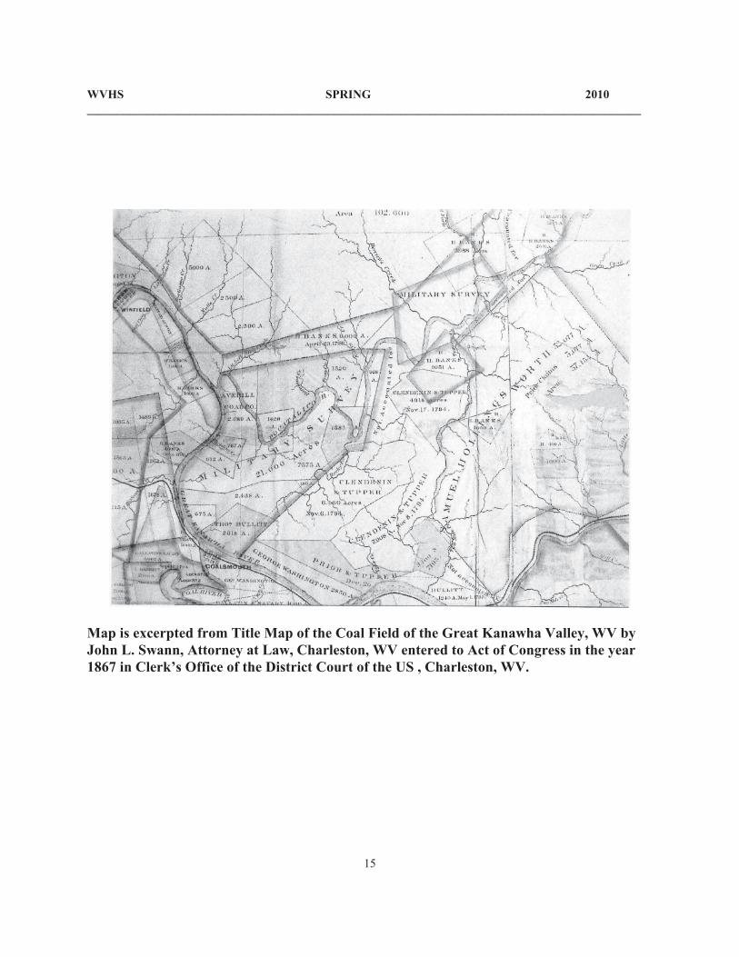
Map is excerpted from Title Map of the Coal Field of the Great Kanawha Valley, WV by John L. Swann, Attorney at Law, Charleston, WV entered to Act of Congress in the year 1867 in Clerk’s Office of the District Court of the US , Charleston, WV.
WVHS Quarterly 2006West Virginia Historical SocietyP.O. Box 5220Charleston, WV 25361-0220