Embed Size (px)
Citation preview

Western Brisbane Transport Network Strategy


ContentsForeword 1
Strategy highlights 2
Introduction 6
Community input and strategy development 10
Rail 12
Bus 16
Active transport 20
Road and freight 24
Implementation 28
Benefits of the strategy 32
This is a strategic vision to provide a framework for planning and delivery of the transport network in western Brisbane. The information on the maps in this document is not intended for reference to specific parcels of land. It should be treated as indicative only and subject to ongoing refinement.
2009
Contact details:
Phone 1800 636 896 www.transport.qld.gov.au/wbtni

The Western Brisbane Transport Network Investigation is a coordinated approach to the ongoing development of the transport network for western Brisbane.
More than a million people were asked for their input into a plan which integrates all modes of transport, such as rail, bus, road, walking and cycling.
The Investigation commenced in 2007, in large part as a means of determining whether the long talked-about Western Brisbane Bypass would happen.
That option was ruled out in 2008 after detailed traffic projections showed insufficient demand but, in keeping with government’s commitments, the planning exercise continued to develop a holistic transport plan for Western Brisbane’s future.
Rail forms the backbone of the plan. The investigation finds that by continuing to expand the rail network, by adding trains and by full sectorisation of the system, capacity can be significantly expanded.
In relation to road transport, the Investigation supports the need for Brisbane City Council’s proposed Northern Link tunnel and it proposes an improved north south road connection including a tunnel linking Toowong to Everton Park.
Much of the work identified in the Western Brisbane Transport Network Investigation is already underway. The rail network is being extended to Richlands and capacity is being expanded between Corinda and Darra. The Northern Busway to Kedron is under construction and so is Airport Link. In addition, the Brisbane City Council is actively pursuing the Northern Link tunnel.
Beyond that, the Western Brisbane Transport Network Strategy provides a planning blueprint for a sustainable transport future for this important part of South East Queensland.
The Honourable Rachel Nolan, MPMinister for Transport
ForewordWestern Brisbane Transport Network Strategy
1

For the first time, a coordinated approach to the transport needs of western Brisbane integrates all types of transport and land use into one strategy, balancing the city’s social, environmental and economic objectives.
Rail
Bus
Active transport
Road and freight
An integrated strategy
2

Western Brisbane Transport Network Strategy
Key strategy components
RailThe staged transformation of the existing rail network to a high capacity surface rail system with new, multi-purpose stations and new carriages designed to minimise stopping times at stations is the centrepiece of the strategy.
It delivers greater service reliability, higher frequency and safety benefits, including best practice signalling and the upgrade of level crossings.
The rail transformation means more frequent trains with the potential to triple the passenger capacity of the rail network.
n Bus lanes and bus priority along existing roads
n Support bus connections to activity centres and the Brisbane Central Business District
n Integrate bus services with rail and make transfers easier
n Rail as the backbone of the transport network
n ‘Turn-up-and-go’ service(no timetable required)
n New multi-purpose stationsn More frequent trains
n Complete the motorway networkn Support bus, cycle and walk within
the corridorn Connect communities and enhance
economic growthn Provide for goods and services
movement
n Walk and cycle facilities integrated into road corridor designs
n Prioritise active transport facilities as part of local urban redevelopment
n Support access to public transport services
Active transport choices – walk and cycleThe strategy provides a continuous network of high standard, easy to follow walking and cycling routes through a combination of bikeways, bike lanes, wide footpaths and river crossings.
An urban community with a well designed active transport system benefits the network at two levels; it supports access to public transport for commuter trips and it promotes sustainable local trips, reducing congestion.
North South MotorwayA motorway between the Ipswich Motorway and the Bruce Highway would assist in managing congestion on other north-south links, and provide flexibility and alternative routes for long distance trips and freight carriage.
Road corridors connect communities through many types of transport. The new road structure for western Brisbane would improve 24-hour accessibility, reduce travel times and make local trips easier.
Bus priorityTransport corridors are community assets. Prioritising freed-up road space for buses maximises the ability to move more people along the corridor.
Bus priority provides direct services to the Brisbane Central Business District and activity centres in corridors not serviced by rail, and supports high capacity rail corridors through improved bus feeder services.
3

Integrated corridor projects
This table shows proposed upgrade projects along corridors. Opportunity for several modes to be packaged as one integrated project has been shown.
This is a strategic framework for future planning and delivery.
Further assessment is required to identify:n social impactn environmental impactn engineering feasibilityn corridor alignmentn economic feasibility,
including government affordability.
This would be carried out in conjunction with further community consultation.
Key Under construction
In planning
UC
IP
Phas
e 1
Phas
e 2
Phas
e 3
2(a) Kenmore to CBDWestern Bus Corridor staged bus lanes + Western Veloway
Rail Bus Active transport Road and freight
5Kedron to CBDNorthern Veloway - Section 1
16Indooroopilly to Dutton ParkUni Link Veloway
12 St Lucia to West EndUni River Link
14Toowong to Everton ParkWestern Ring Veloway
15Brisbane CBDAlbert Street Garden Axis Veloway
7 Toowong to Kelvin GroveTransApex Northern Link tunnel
13 Toowong to Everton ParkInner Orbital tunnel
17(b)Darra to ToowongCentenary Motorway upgrade
18Everton Park to KedronStafford Road tunnel
8Everton Park to KedronStafford Road transit lanes + Stafford Road Veloway
9Kelvin Grove to AshgroveMusgrave Road-Waterworks Road bus lanes + Gap Access Veloway
10Kelvin Grove to Everton ParkKelvin Grove Road-Enoggera Road bus lanes + North Western Veloway - Section 1
11North West Transport CorridorNorth west bus lanes + North Western Veloway - Section 2 + North West Motorway
4(c) Kedron to AspleyNorthern Busway - Staged upgrade + Northern Veloway - Section 2
4(b)Kedron to AspleyNorthern Busway - Staged upgrade + Northern Veloway - Section 2
2(b)Kenmore to CBDWestern Bus Corridor staged bus lanes + Western Veloway
n Park ‘n’ Ride
n Station and interchange upgrades
n Bus Transport Improvement Program
n Active Transport Programs
n Active Transport Programs
n Park ‘n’ Ride
n Station and interchange upgrades
n Bus Transport Improvement Program
n Road Corridor Improvement Program
n Road Corridor Improvement Program
n Implement current rail projects*
n Sectorisation of lines
n New timetables
n Park ‘n’ Ride upgrades
n Level crossing upgrades
n Active Transport Programs
n Implement current rail projects*
n Purchase new carriages
n Station and interchange upgrades
n Level crossing upgrades
n Stabling upgrades
n Signalling upgrades
n Implement current rail projects*
n Purchase new carriages
n Station and interchange upgrades
n Level crossing upgrades
n Stabling upgrades
n Signalling upgrades
n Road Corridor Improvement Program
17(a) Darra to ToowongCentenary Motorway upgrade
6Clem Jones tunnel to Gateway MotorwayAirport Link*
UCUC
4(a)Kedron to AspleyStaged bus lanes IP
3 Darra to IndooroopillyCentenary Motorway transit lanes*
IP
IPIP
IP
IP
* Project already in the South East Queensland Infrastructure Plan and Program (SEQIPP)
Herston to KedronNorthern Busway* UC1
4

Western Brisbane Transport Network Strategy
SOUTH EAST BUSWAY
EASTERN BUSWAY16
17
18
2
13
9
4
15
10
6
15
8
11
3
7
12
14
STRATHPINESTRATHPINE
BRAY PARKBRAY PARK
ALBANYCREEKALBANYCREEK
ASPLEYASPLEY
CHERMSIDECHERMSIDE NORTHGATENORTHGATE
ZILLMEREZILLMERE
MT COOT-THAMT COOT-THA
KEDRONKEDRON
ALBIONALBION
BOWEN HILLSBOWEN HILLSTHE GAPTHE GAP
KENMOREKENMORE
DARRADARRA
OXLEYOXLEY
CBD
CARSELDINECARSELDINE
ALDERLEYALDERLEY
MITCHELTON MITCHELTON
FERNY GROVEFERNY GROVE
TOOWONGTOOWONG
MILTONMILTON
INDOOROOPILLYINDOOROOPILLY
IPSWICHIPSWICH
GOODNAGOODNA
RICHLANDSRICHLANDS
WACOLWACOL
REDBANKREDBANKDINMOREDINMORE
LOGAN MWY
IPSWICH MWY
PACIFIC MW
YG
ATEWAY M
WY
CEN
TEN
ARY
MW
Y
0 42Km
NORTH
Legend
Rail
Bus
Active transport
Road and freight
River Link
Upgraded Park ‘n’ Ride
Grade separation program
Committed TOD(Transit Oriented Development)
Activity centre
Existing or committed major roads
Existing or committed busways
Existing rail lines
2026 urban footprint
NORTH
Not to scale
Integrated network strategy
This is a strategic concept and no impacts have been determined 5

IntroductionChallenges we facePopulation growth, climate change and rising fuel costs are exerting increasing pressure on the transport network in South East Queensland. The challenge is to develop a transport network that successfully responds to these pressures while protecting the environment and lifestyle that the community values.
Specific challenges include:n managing population growthn managing patronage growth on passenger
transport servicesn managing peak hour congestionn reducing freight movement costsn managing rising transport and fuel costsn managing construction and maintenance costs.
Climate change, peak oil and rising transport costsThe rising cost of crude oil has significantly increased transport costs, accelerating a move from cars to public transport.
The strategy’s focus on rail and bus priority provides a sustainable network system with the capacity and flexibility to manage the uncertain future challenges.
The strategy balances the competing objectives of accessibility, economic development and sustainability. Investing only in roads will not achieve sustainability, deal with higher transport costs or address the issues of climate change and emissions reduction. Likewise, investing only in public transport will not provide for region-wide accessibility, support economic development, improve goods delivery reliability or reduce freight costs.
The strategy is a 20-year vision to guide all levels of government. It is a fully integrated, multi-modal approach to transforming the transport network of western Brisbane based on the key principles of:n making better use of existing infrastructuren building on current infrastructure programsn prioritising transport corridor space.
Our response
6
Western Brisbane Transport Network Strategy
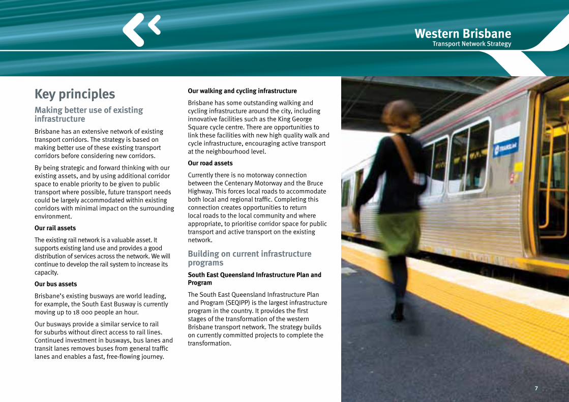
Key principlesMaking better use of existing infrastructureBrisbane has an extensive network of existing transport corridors. The strategy is based on making better use of these existing transport corridors before considering new corridors.
By being strategic and forward thinking with our existing assets, and by using additional corridor space to enable priority to be given to public transport where possible, future transport needs could be largely accommodated within existing corridors with minimal impact on the surrounding environment.
Our rail assets
The existing rail network is a valuable asset. It supports existing land use and provides a good distribution of services across the network. We will continue to develop the rail system to increase its capacity.
Our bus assets
Brisbane’s existing busways are world leading, for example, the South East Busway is currently moving up to 18 000 people an hour.
Our busways provide a similar service to rail for suburbs without direct access to rail lines. Continued investment in busways, bus lanes and transit lanes removes buses from general traffic lanes and enables a fast, free-flowing journey.
Our walking and cycling infrastructure
Brisbane has some outstanding walking and cycling infrastructure around the city, including innovative facilities such as the King George Square cycle centre. There are opportunities to link these facilities with new high quality walk and cycle infrastructure, encouraging active transport at the neighbourhood level.
Our road assets
Currently there is no motorway connection between the Centenary Motorway and the Bruce Highway. This forces local roads to accommodate both local and regional traffic. Completing this connection creates opportunities to return local roads to the local community and where appropriate, to prioritise corridor space for public transport and active transport on the existing network.
Building on current infrastructure programsSouth East Queensland Infrastructure Plan and Program
The South East Queensland Infrastructure Plan and Program (SEQIPP) is the largest infrastructure program in the country. It provides the first stages of the transformation of the western Brisbane transport network. The strategy builds on currently committed projects to complete the transformation.
7

Into the futureThe strategy supports sustainable planning principles that will guide development in western Brisbane beyond the timeframes of the South East Queensland Regional Plan such as:n affordable urban housing and smart
design standardsn market-driven employment in the
Brisbane Central Business District and surrounding areas with supporting transport
n greater use of rail and development of new activity centres and Transit Oriented Development (TOD) centres around major rail stations.
Prioritising transport corridor spaceCorridor space as a community asset
Each transport corridor is a valuable asset that should be used for maximum community benefit.
A general purpose arterial road lane has a capacity of up to 2000 people per hour. The same lane operating as a bus lane has a capacity of up to 5000 people per hour. A busway lane can move up to 18 000 people per hour. Rail can carry up to 30 000 people per hour.
A fundamental principle of the strategy is to capitalise on opportunities to make better use of corridor space to increase the number of people who can use it, particularly during peak periods.
Providing attractive alternatives for private vehicles can free up road space in some corridors. This corridor space can be prioritised for buses and active transport. For example, the transfer of traffic to faster corridors such as Northern Link and the North West Transport Corridor could provide an opportunity to reprioritise the freed-up road space on Moggill Road-Coronation Drive and Gympie Road for bus lanes.
Enabling better use of walking, cycling and public transport helps manage congestion and also provides opportunities for urban regeneration.
Providing more frequent rail services will increase the number of people who can use those corridors and reduce road congestion without the need for new corridors.
8

Western Brisbane Transport Network Strategy
Artist’s impression: urban regeneration
9

Community participation has been fundamental to developing the strategy. Understanding community issues, concerns, needs and desires has influenced the development of the strategy.
Transport issues that have been considered were identified through contact with over 3000 people at staffed displays, almost 4000 recorded public submissions and comments, and active participation by two community liaison groups. The community was looking for:n ongoing improvements to the existing transport
network as well as new infrastructuren improved access, connectivity, frequency and
reliability for public transportn a more comfortable and reliable rail network
with greater carrying capacityn public transport that is well promoted and easy
to usen transport decisions that protect the semi-rural
and village lifestyles in areas outside, or on the perimeter, of the urban footprint
n planning for a future that considers population growth, changing working conditions, climate change and demand on oil supplies
CongestionKey issues raised through community consultation were peak hour traffic congestion, overcrowding on public transport and buses being caught up in general traffic. These concerns shaped the design of the strategy.
The community also wanted the strategy to consider: n ways to reduce trip timesn appropriate use of main and local roadsn roads linking or bypassing the cityn improvements to residential amenityn environmental impacts.
Community input and strategy development
103
187
20134
29
187 Public Transport
103 Road Corridors
29 Active Transport
20 Other
13 Freight
4 No answer
Priority planning issuesCommunity survey results
The ability to move freely amongst a community is a quality of life issue. No one enjoys being stuck in traffic, increasing one’s travel time and stress. Equally no one who uses public transport appreciates having to use congested carriages or buses and having to wait for a bus or train that is not overcrowded.
Community comment: Survey 1, February 2008Survey 1, February 2008
10

Western Brisbane Transport Network Strategy
Planning for an uncertain futureThe investigation recorded an increasing awareness and community concern about the role transport networks can play in responding to the challenges of rising costs, climate change and sustainability. Feedback included comments on the:n rising costs of fuel and peak oil concernsn effect of vehicle emissions on the environmentn environmental impact of building new transport
infrastructuren reduction of carbon footprint by choosing
public and active transport options.
Reducing dependency on private vehicles and increasing the use of public transport were commonly identified solutions for mitigating the effects of climate change and peak oil.
Some members of the community also expressed their concerns about:n uncertainty about possible land resumptionsn timing of infrastructure projects n social impact of building new infrastructure
and opening up land usen associated property and lifestyle impacts,
including vibration, noise, air quality, loss of neighbouring greenspace.
Public transportThe community consistently rated public transport as one of the top issues. The majority of comments indicated a strong demand for increased public transport in western Brisbane.
Improvements in rail station access, increased services, parking at stations and connectivity between types of transport were all identified as areas for improvement. Rail was also seen as the best form of public transport due to its reliability, comfort, greater passenger capacity and perception as the lowest polluting form of public transport.
Feedback indicated people would use public transport more if they believed it was:n reliable and about as fast as private car traveln safe at all hours of the day and nightn a comfortable journey, with space on board for
all passengers
These plans seem good and necessary. The main emphasis should be on burning less hydrocarbons, urgently. Thanking you in anticipation.
Terms of Reference submission, Wishart
…increasing public transport, particularly introducing or expanding transport technologies not reliant on oil, would seem the wisest option.
Community comment: April 2008, St Lucia
11

Rail Brisbane has an extensive and established rail network. With a growing population and strong economy, the suburban railway will need to play a bigger role in the transport network into the future.
The transformation of rail over 20 years is the centrepiece of the strategy, delivering frequent and reliable services.
The vision is for a system similar to many above ground railways in European cities, such as Paris and Berlin, which offer high frequency ‘turn-up-and-go’ services to suburban populations.
The rail transformation would mean more frequent trains, and faster boarding and alighting at stations, with the potential to significantly increase the existing passenger capacity of the rail network.
n Transform Brisbane’s suburban rail services with ‘turn-up-and-go’, citywide services
n A network of attractive and leading multi-purpose station centres, supporting a denser and sustainable world city
n A trusted backbone of the region’s social daily activity
Vision
12

Western Brisbane Transport Network Strategy
n Public transport as a foundation for sustainable urban development
n Enhanced use of existing rail infrastructure
n Rail as the backbone of the transport network
n Integrated rail, bus, walk and cycle facilities across the network
n New, state of the art trains
n Easier, more attractive transfers between car, bus and rail
n High-frequency, ‘no timetable’ services
Artist’s impression: rail station
Principles
13

The strategy builds on currently planned projects identified in the South East Queensland Infrastructure Plan and Program (SEQIPP) and delivers a 20-year staged program of rail upgrades including:n sectorisation – operating the rail network as
two independent units provides the ability to increase frequency and reliability of services during peak periods (as pictured right). This is a key to unlocking the full potential of the rail network
n new timetables – complete sectorisation enables frequent and regularly spaced services over a two hour peak period in the morning and afternoon
n stabling upgrades – providing additional areas for train storage
n signalling upgrades – required for the operation of high frequency services
n station upgrades – multi-purpose stations provide an efficient and comfortable experience for passengers and support transit oriented development
n new carriages – train carriages designed for faster boarding and alighting, and more standing room
n level crossing upgrades – provide safety and efficiency benefits to the rail and road networks.
to Airport
to Shorncliffe
to Caboolture
to Ferny Grove
to Springfield
to Cleveland
to Ipswich to Beenleighand Robina
Bowen Hills
Fortitude Valley
Central
Roma Street
to Doomben
Complete sectorisation of lines Phase 2This phase continues the transformation. The outcome would be an increase in services during peak hours, improved safety by removing level crossings and the introduction of new carriages capable of carrying more passengers. This phase includes implementing current SEQIPP projects such as the Keperra to Ferny Grove track duplication and the Darra to Springfield rail line.
Other works could include:n new high capacity carriagesn progressive upgrade of level crossingsn station and bus-rail interchange upgradesn signalling upgradesn stabling upgrades.
Phase 3Major signalling improvements and new carriages would enable rail to move up to 30 000 people per hour. This is significantly more than the existing demand. Completion of station redevelopments, bus feeder systems and level crossing upgrades complete the transformation. This phase includes implementing current SEQIPP projects such as the Darra to Redbank third track.
Other works could include:n signalling upgradesn new high capacity carriagesn upgrade remaining stations n upgrade remaining level crossingsn stabling upgrades.
Phase 1This phase starts the staged conversion of the existing rail network to a high capacity surface rail system. It includes implementing current SEQIPP projects such as the Corinda to Darra third track.
Other works could include:n independent operation (sectorisation) of the
Brisbane rail networkn timetable reviews to ensure regular, simple and
consistent services and stopping patternsn progressive upgrade of level crossingsn Park ‘n’ Ride upgrades.
14
Western Brisbane Transport Network Strategy
STRATHPINESTRATHPINE
BRAY PARKBRAY PARK
ALBANYCREEKALBANYCREEK
ASPLEYASPLEY
CHERMSIDECHERMSIDE NORTHGATENORTHGATE
ZILLMEREZILLMERE
MT COOT-THAMT COOT-THA
KEDRONKEDRON
ALBIONALBION
BOWEN HILLSBOWEN HILLSTHE GAPTHE GAP
KENMOREKENMORE
DARRADARRA
OXLEYOXLEY
CBD
CARSELDINECARSELDINE
ALDERLEYALDERLEY
MITCHELTON MITCHELTON
FERNY GROVEFERNY GROVE
TOOWONGTOOWONG
MILTONMILTON
INDOOROOPILLYINDOOROOPILLY
IPSWICHIPSWICH
GOODNAGOODNA
RICHLANDSRICHLANDS
WACOLWACOL
REDBANKREDBANKDINMOREDINMORE
LOGAN MWY
IPSWICH MWY
PACIFIC MW
YG
ATEWAY M
WY
CEN
TEN
ARY
MW
Y
0 42Km
NORTH
Legend
Rail
Upgraded Park ‘n’ Ride
Grade separation program
Committed TOD(Transit Oriented Development)
Activity centre
Existing rail lines
2026 urban footprint
NORTH
Not to scale
This is a strategic concept and no impacts have been determined
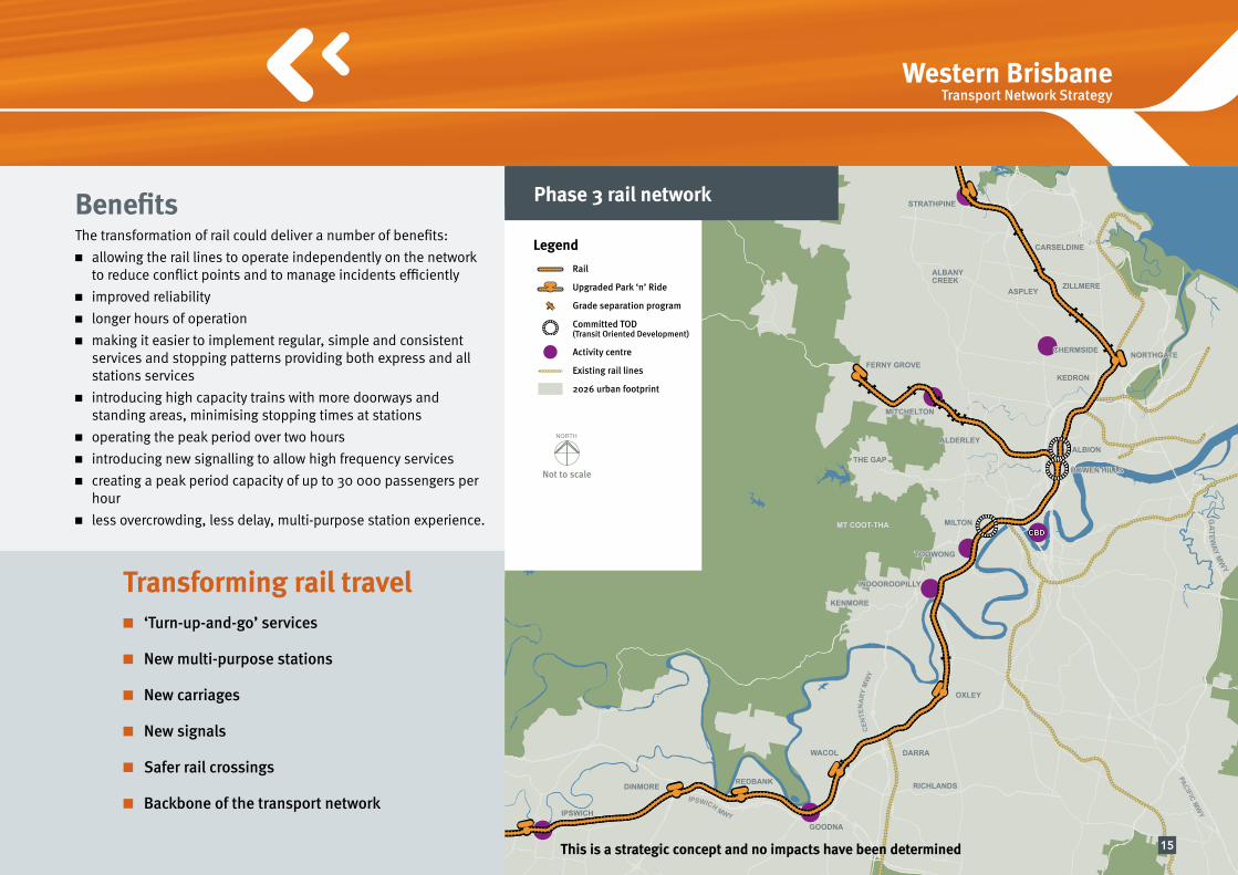
Phase 3 rail networkBenefitsThe transformation of rail could deliver a number of benefits:n allowing the rail lines to operate independently on the network
to reduce conflict points and to manage incidents efficientlyn improved reliabilityn longer hours of operationn making it easier to implement regular, simple and consistent
services and stopping patterns providing both express and all stations services
n introducing high capacity trains with more doorways and standing areas, minimising stopping times at stations
n operating the peak period over two hoursn introducing new signalling to allow high frequency services n creating a peak period capacity of up to 30 000 passengers per
hourn less overcrowding, less delay, multi-purpose station experience.
Transforming rail traveln ‘Turn-up-and-go’ services
n New multi-purpose stations
n New carriages
n New signals
n Safer rail crossings
n Backbone of the transport network
15

Bus Over the past 10 years, Brisbane’s bus network has undergone a significant transformation. A network of bus priority measures, bus lanes and busways have been planned and built. Already, the South East Busway at Woolloongabba is carrying about 18 000 passengers per hour in the morning peak.
The vision of this strategy is for this transformation to continue in western Brisbane with a series of fit for purpose facilities that could be expanded and developed as demand for travel grows.
The strategy recognises that buses need their own right-of-way to be able to provide frequent and regular services with predictable travel times.
Rail requires support from a network of buses, together with improved bus-rail interchanges to feed the rail system and extend its reach. For areas outside the rail corridors, buses need to fill in the gaps. Real choices in frequent and reliable public transport are seen as the crucial element of the strategy to manage congestion and curb reliance on private transport.
Throughout the life of the strategy, existing bus-rail interchanges will be upgraded to improve access, convenience, comfort, safety and security for users. More rail and bus stations would be provided with quality and accessible pedestrian facilities to extend each station’s walk-in catchment. Passengers’ ability to change modes would be greatly improved.
n Continue the transformation of Brisbane’s bus system
n A bus system that provides frequent, reliable services both to the Brisbane Central Business District and major activity centres that are not serviced by the rail network
n Extending the reach of the rail network by providing frequent and reliable feeder services to priority rail stations
n A viable travel choice to reduce car dependency
n A network that promotes sustainable land use changes along key public transport corridors
Vision
16

Western Brisbane Transport Network Strategy
Principlesn Prioritise road corridor space to maximise
efficiency of public transport
n Integrated bus and rail services
n Effective interchanges to make transfers easier
n Continued enhancement of integrated ticketing and fares
n Safe, comfortable access and services
n Bus priority on selected corridors
n Busways delivering rail-like services
n Future road programs to prioritise buses
n Support bus connections to activity centres and the Brisbane Central Business District
Artist’s impression
17

Transforming bus traveln Priority for buses
n Frequent and reliable services
n Integration with rail
n Extending the reach of rail
n Filling in the gaps
Phase 1Works could include:n An extension of the Northern Busway which
is being constructed to Kedron by 2012. Ultimately, it is envisaged that this busway could extend to Bracken Ridge. In the first phase, additional bus lanes could be constructed from the busway at Kedron and within the Gympie Road corridor to Chermside. Where feasible, bus priority measures could be provided at intersections
n The construction of Northern Link and the resolution of the Moggill Road congestion at Kenmore, currently under investigation by the Department of Transport and Main Roads, could provide an opportunity to commence the staged construction of the Western Bus Corridor between the Brisbane Central Business District and Kenmore along the Coronation Drive and Moggill Road corridors
n With the upgrade of Stafford Road for transit lanes, bus services could be provided linking the north western suburbs and Ferny Grove rail line at Mitchelton and Alderley stations with the Australia TradeCoast (Port of Brisbane and Brisbane Airport). This would extend the reach of the public transport system without having to travel through the Brisbane Central Business District
n Transit lanes could be provided along the Centenary Motorway between Darra and Indooroopilly as currently planned.
Phase 2Works could include: n the completion of the Western Bus Corridor
with bus lanes between Kenmore and the Brisbane Central Business District
n the extension of bus lanes along Gympie Road to Aspley. These could be progressively upgraded towards busway-standard in conjunction with the construction of the North West Motorway that would significantly reduce traffic volumes on Gympie Road
n bus lanes along the Kelvin Grove Road-Enoggera Road corridor
n bus lanes along the Musgrave Road-Waterworks Road corridor
n bus priority on the North West Motorway with a bus only link to the bus lanes on the Kelvin Grove Road-Enoggera Road corridor
n Bus Transport Improvement Program.
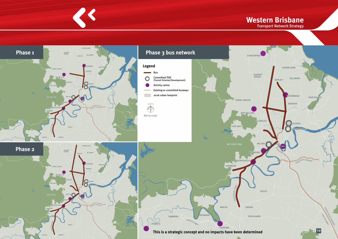
Phase 3Works could include: n the progressive conversion of the Gympie
Road bus lanes to a busway as demand on the system grows.
n Bus Transport Improvement Program.
Bus priority on selected corridorsBus priority on selected corridors would provide direct services to the Brisbane Central Business District and activity centres in corridors that are not serviced by rail. It would support high capacity rail corridors via bus feeder services.
The Northern Busway extension (Kedron to Aspley) would enable land use integration and urban revitalisation.
18
Western Brisbane Transport Network Strategy
SOUTH EAST BUSWAY
EASTERN BUSWAY
STRATHPINESTRATHPINE
BRAY PARKBRAY PARK
ALBANYCREEKALBANYCREEK
ASPLEYASPLEY
CHERMSIDECHERMSIDE NORTHGATENORTHGATE
ZILLMEREZILLMERE
MT COOT-THAMT COOT-THA
KEDRONKEDRON
ALBIONALBION
BOWEN HILLSBOWEN HILLSTHE GAPTHE GAP
KENMOREKENMORE
DARRADARRA
OXLEYOXLEY
CBD
CARSELDINECARSELDINE
ALDERLEYALDERLEY
MITCHELTON MITCHELTON
FERNY GROVEFERNY GROVE
TOOWONGTOOWONG
MILTONMILTON
INDOOROOPILLYINDOOROOPILLY
IPSWICHIPSWICH
GOODNAGOODNA
RICHLANDSRICHLANDS
WACOLWACOL
REDBANKREDBANKDINMOREDINMORE
LOGAN MWY
IPSWICH MWY
PACIFIC MW
YG
ATEWAY M
WY
CEN
TEN
ARY
MW
Y
0 42Km
NORTH
Legend
Bus
Committed TOD(Transit Oriented Development)
Activity centre
Existing or committed busways
2026 urban footprint
NORTH
Not to scale
SOUTH EAST BUSWAY
EASTERN BUSWAY
STRATHPINESTRATHPINE
BRAY PARKBRAY PARK
ALBANYCREEKALBANYCREEK
ASPLEYASPLEY
CHERMSIDECHERMSIDE NORTHGATENORTHGATE
ZILLMEREZILLMERE
MT COOT-THAMT COOT-THA
KEDRONKEDRON
ALBIONALBION
BOWEN HILLSBOWEN HILLSTHE GAPTHE GAP
KENMOREKENMORE
DARRADARRA
OXLEYOXLEY
CBD
CARSELDINECARSELDINE
ALDERLEYALDERLEY
MITCHELTON MITCHELTON
FERNY GROVEFERNY GROVE
TOOWONGTOOWONG
MILTONMILTON
INDOOROOPILLYINDOOROOPILLY
IPSWICHIPSWICH
GOODNAGOODNA
RICHLANDSRICHLANDS
WACOLWACOL
REDBANKREDBANKDINMOREDINMORE
LOGAN MWY
IPSWICH MWY
PACIFIC MW
YG
ATEWAY M
WY
CEN
TEN
ARY
MW
Y
0 42Km
NORTH
This is a strategic concept and no impacts have been determined
Phase 3 bus networkPhase 1
Phase 2
19

Walking and cyclingFor western Brisbane, walking and cycling can be viable options to increase travel choices and access to public transport.
Walking and cycling have the potential to replace car use, especially for local and school trips. Active transport also contributes to the reduction of congestion, air pollution and greenhouse emissions, and contributes to positive community, health and personal wellbeing outcomes.
The introduction of a network of innovative, world class walk and cycle infrastructure and facilities would encourage significant changes in travel behaviours.
The strategy vision is for a continuous network of high standard, easy to follow walking and cycling routes in major corridors.n Veloways are wide and high quality cycleways,
providing a network of safe, dedicated and direct routes between key locations. Their design would encourage a wider sector of the community to use active transport for commuting, travelling to school and recreation.
n River Links increase the number of locations to cross the Brisbane River. They improve access between neighbourhoods and to public transport for pedestrians and cyclists encouraging even more people to walk and cycle.
In addition, all road and public transport corridor upgrades incorporate walk and cycle facilities.
Active transport
Vision n Reduced car dependency
n A healthier community
n Network of linked, high quality walk and cycle infrastructure
Artist’s impression: veloway
20

Western Brisbane Transport Network Strategy
n A network of safe, easy to follow and accessible commuter cycle and pedestrian routes
n Direct connections to publictransport networks
n Provide safe opportunities to reduce individual carbon footprint
n Active street fronts creating a sense of place and encouraging activity
n Walking and cycling facilities in neighbourhoods to support local trips
n Facilities and initiatives to promote walking and cycling to school
n An integral component of every public transport and road project
n Plan and encourage urban design and new developments to follow active transport guidelines
Principles
More walking and cyclingWalking and cycling account for less than 11 per cent of the total trips made on the network.
The strategy aims to significantly increase walking and cycling.
Artist’s impression: River Link at night
Artist’s impression: School Safety Zone
21

Changing travel behaviour and reducing the carbon footprintThe strategy identifies innovative measures and strategic actions required to increase walking and cycling, influence travel behaviour and allow people to reduce their carbon footprint. These are:n Active neighbourhoods comprising high
quality, user-friendly pedestrian and cycle infrastructure and facilities to support local, utility and recreational trips
n School safety improvements comprising engineering, enforcement and awareness-raising measures, such as road narrowing, electronic signage and traffic calming, to encourage children to walk and cycle to school
n Programs that connect and integrate public and active transport, such as pedestrian and cycle routes to connect to rail and bus stations. These stations could also include cycle facilities.
Transforming active transportn New cycleways and walkways
n Innovative corridor planning
n New river crossings
n Neighbourhood access
n Healthier choices
Phase 1This phase includes a number of strategic cycle programs to transform Brisbane’s western suburbs, including implementing current SEQIPP projects such as the Western Corridor sub-regional cycle network.
Other works could include:n Veloways - Stafford Road Veloway - Northern Veloway (Kedron to Brisbane Central
Business District) - staged Western Veloway (Kenmore to
Brisbane Central Business District)n Active neighbourhoods, school safety
improvements and programs to integrate public and active transport could be progressively implemented.
Phase 2This phase continues the transformation of Brisbane’s western suburbs.
Works could include: n Veloways - complete the Western Veloway - Gap Access Veloway (Ashgrove to Brisbane
Central Business District) - staged North Western Veloway (Carseldine to
Kelvin Grove) - extension of Northern Veloway to Aspleyn pedestrian and cycle bridge - Uni River Link (St Lucia to West End)n Active neighbourhoods, school safety
improvements and programs to integrate public and active transport could be progressively implemented.
Phase 3Works could include:n Veloways - complete the Northern Veloway - Western Ring Veloway (Toowong to
Everton Park) - Albert Street Garden Axis Veloway - Uni Link Veloway (Indooroopilly to
Dutton Park)n Active neighbourhoods, school safety
improvements and programs to integrate public and active transport could be progressively implemented.
22

Western Brisbane Transport Network Strategy
STRATHPINESTRATHPINE
BRAY PARKBRAY PARK
ALBANYCREEKALBANYCREEK
ASPLEYASPLEY
CHERMSIDECHERMSIDE NORTHGATENORTHGATE
ZILLMEREZILLMERE
MT COOT-THAMT COOT-THA
KEDRONKEDRON
ALBIONALBION
BOWEN HILLSBOWEN HILLSTHE GAPTHE GAP
KENMOREKENMORE
DARRADARRA
OXLEYOXLEY
CBD
CARSELDINECARSELDINE
ALDERLEYALDERLEY
MITCHELTON MITCHELTON
FERNY GROVEFERNY GROVE
TOOWONGTOOWONG
MILTONMILTON
INDOOROOPILLYINDOOROOPILLY
IPSWICHIPSWICH
GOODNAGOODNA
RICHLANDSRICHLANDS
WACOLWACOL
REDBANKREDBANKDINMOREDINMORE
LOGAN MWY
IPSWICH MWY
PACIFIC MW
YG
ATEWAY M
WY
CEN
TEN
ARY
MW
Y
0 42Km
NORTH
Legend
Active transport
River Link
Committed TOD(Transit Oriented Development)
Activity centre
2026 urban footprint
NORTH
Not to scale
STRATHPINESTRATHPINE
BRAY PARKBRAY PARK
ALBANYCREEKALBANYCREEK
ASPLEYASPLEY
CHERMSIDECHERMSIDE NORTHGATENORTHGATE
ZILLMEREZILLMERE
MT COOT-THAMT COOT-THA
KEDRONKEDRON
ALBIONALBION
BOWEN HILLSBOWEN HILLSTHE GAPTHE GAP
KENMOREKENMORE
DARRADARRA
OXLEYOXLEY
CBD
CARSELDINECARSELDINE
ALDERLEYALDERLEY
MITCHELTON MITCHELTON
FERNY GROVEFERNY GROVE
TOOWONGTOOWONG
MILTONMILTON
INDOOROOPILLYINDOOROOPILLY
IPSWICHIPSWICH
GOODNAGOODNA
RICHLANDSRICHLANDS
WACOLWACOL
REDBANKREDBANKDINMOREDINMORE
LOGAN MWY
IPSWICH MWY
PACIFIC MW
YG
ATEWAY M
WY
CEN
TEN
ARY
MW
Y
0 42Km
NORTH
This is a strategic concept and no impacts have been determined
Phase 3 active transport networkPhase 1
Phase 2
23

Road and freight Completing the networkRoad corridors connect communities and provide travel flexibility by catering for cars, buses, pedestrians and cyclists. They are vital for economic growth and essential for effective freight movement and goods distribution.
At present, there is a major gap in the motorway network in western Brisbane between the Centenary Motorway and the Bruce Highway for north-south movements. Through traffic is forced to share roads with local traffic, adding to congestion and travel times. The strategy builds on currently planned projects to complete the motorway network and cater for the demands of private, commercial and bus transport.
Completing the road network structure in western Brisbane including local road improvements, would improve accessibility, reduce travel times and make local and regional trips easier over all periods of the day.
Vision n Provide for longer distance trips west of Brisbane Central Business District
n Free up local streets for walking, cycling and public transport
n Promote economic development
Artist’s impression: road near school
24

Western Brisbane Transport Network Strategy
North South MotorwayThe North South Motorway is a motorway connecting the Ipswich Motorway at Darra to the Bruce Highway. The North South Motorway could provide flexibility and an alternative route for long distance trips west of Brisbane Central Business District, including freight.
It is made up of three sections:n Centenary Motorway
(Ipswich Motorway to Toowong) The upgraded Centenary Motorway is the southern
section of the North South Motorway.
In conjunction with Northern Link and Airport Link, it also forms a motorway connection from the west to the Gateway Motorway and key growth areas such as the Australia TradeCoast (Port of Brisbane and Brisbane Airport).
n Inner Orbital (Toowong to Everton Park) The Inner Orbital, a tunnel from Toowong to Everton
Park, is the middle section of the North South Motorway. It could promote the revitalisation of suburbs such as Bardon by reducing traffic on local roads and provide opportunities for public transport, walking and cycling.
n North West Motorway (North West Transport Corridor)
The northern section of the North South Motorway utilises the existing, preserved transport corridor between Everton Park and Carseldine.
Together with east-west improvements along the Stafford Road corridor, it would provide an alternative to the Gateway Motorway and improve access to the Australia TradeCoast (Port of Brisbane and Brisbane Airport). By reducing traffic volumes on Gympie Road, it would allow the progressive upgrade of bus lanes to busway-standard within the existing corridor.
n Establish and maintain an effective road network hierarchy
n Connect western Brisbane to regional centres
n Manage congestion on the arterial and motorway network
n Deliver a more efficient road network
n Promote reliable goods distribution
n Provide opportunities to give priority to buses and active transport
n Make better use of existing corridors
n Protect the natural environment and minimise adverse effects on communities
PrinciplesNo Western BypassTechnical investigations showed a western bypass would not attract enough traffic from the existing network to relieve congestion in western Brisbane or deliver value for money. A western bypass would also promote development outside the urban footprint set in the South East Queensland Regional Plan, impacting on the semi-rural and village lifestyles in these areas.
The North South Motorway is a key component of the strategy that provides for long distance trips. Unlike a western bypass, the North South Motorway is also forecast to significantly reduce traffic on other roads in western Brisbane, providing opportunities for public and active transport.
25
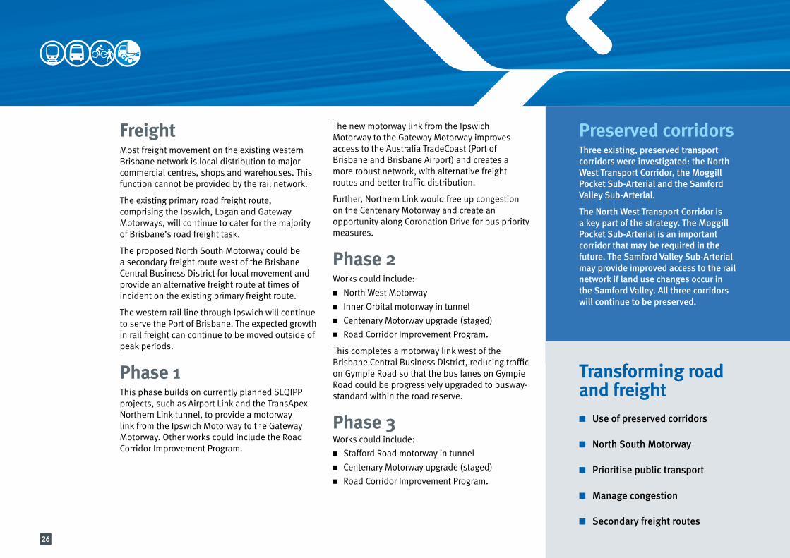
FreightMost freight movement on the existing western Brisbane network is local distribution to major commercial centres, shops and warehouses. This function cannot be provided by the rail network.
The existing primary road freight route, comprising the Ipswich, Logan and Gateway Motorways, will continue to cater for the majority of Brisbane’s road freight task.
The proposed North South Motorway could be a secondary freight route west of the Brisbane Central Business District for local movement and provide an alternative freight route at times of incident on the existing primary freight route.
The western rail line through Ipswich will continue to serve the Port of Brisbane. The expected growth in rail freight can continue to be moved outside of peak periods.
Phase 1This phase builds on currently planned SEQIPP projects, such as Airport Link and the TransApex Northern Link tunnel, to provide a motorway link from the Ipswich Motorway to the Gateway Motorway. Other works could include the Road Corridor Improvement Program.
The new motorway link from the Ipswich Motorway to the Gateway Motorway improves access to the Australia TradeCoast (Port of Brisbane and Brisbane Airport) and creates a more robust network, with alternative freight routes and better traffic distribution.
Further, Northern Link would free up congestion on the Centenary Motorway and create an opportunity along Coronation Drive for bus priority measures.
Phase 2Works could include:n North West Motorwayn Inner Orbital motorway in tunneln Centenary Motorway upgrade (staged)n Road Corridor Improvement Program.
This completes a motorway link west of the Brisbane Central Business District, reducing traffic on Gympie Road so that the bus lanes on Gympie Road could be progressively upgraded to busway-standard within the road reserve.
Phase 3Works could include:n Stafford Road motorway in tunneln Centenary Motorway upgrade (staged)n Road Corridor Improvement Program.
Transforming road and freightn Use of preserved corridors
n North South Motorway
n Prioritise public transport
n Manage congestion
n Secondary freight routes
Preserved corridorsThree existing, preserved transport corridors were investigated: the North West Transport Corridor, the Moggill Pocket Sub-Arterial and the Samford Valley Sub-Arterial.
The North West Transport Corridor is a key part of the strategy. The Moggill Pocket Sub-Arterial is an important corridor that may be required in the future. The Samford Valley Sub-Arterial may provide improved access to the rail network if land use changes occur in the Samford Valley. All three corridors will continue to be preserved.
26

Western Brisbane Transport Network Strategy
STRATHPINESTRATHPINE
BRAY PARKBRAY PARK
ALBANYCREEKALBANYCREEK
ASPLEYASPLEY
CHERMSIDECHERMSIDE NORTHGATENORTHGATE
ZILLMEREZILLMERE
MT COOT-THAMT COOT-THA
KEDRONKEDRON
ALBIONALBION
BOWEN HILLSBOWEN HILLSTHE GAPTHE GAP
KENMOREKENMORE
DARRADARRA
OXLEYOXLEY
CBD
CARSELDINECARSELDINE
ALDERLEYALDERLEY
MITCHELTON MITCHELTON
FERNY GROVEFERNY GROVE
TOOWONGTOOWONG
MILTONMILTON
INDOOROOPILLYINDOOROOPILLY
IPSWICHIPSWICH
GOODNAGOODNA
RICHLANDSRICHLANDS
WACOLWACOL
REDBANKREDBANKDINMOREDINMORE
LOGAN MWY
IPSWICH MWY
PACIFIC MW
YG
ATEWAY M
WY
CEN
TEN
ARY
MW
Y
0 42Km
NORTH
Legend
Road and freight
Activity centre
Existing or committed major roads
2026 urban footprint
NORTH
Not to scale
STRATHPINESTRATHPINE
BRAY PARKBRAY PARK
ALBANYCREEKALBANYCREEK
ASPLEYASPLEY
CHERMSIDECHERMSIDE NORTHGATENORTHGATE
ZILLMEREZILLMERE
MT COOT-THAMT COOT-THA
KEDRONKEDRON
ALBIONALBION
BOWEN HILLSBOWEN HILLSTHE GAPTHE GAP
KENMOREKENMORE
DARRADARRA
OXLEYOXLEY
CBD
CARSELDINECARSELDINE
ALDERLEYALDERLEY
MITCHELTON MITCHELTON
FERNY GROVEFERNY GROVE
TOOWONGTOOWONG
MILTONMILTON
INDOOROOPILLYINDOOROOPILLY
IPSWICHIPSWICH
GOODNAGOODNA
RICHLANDSRICHLANDS
WACOLWACOL
REDBANKREDBANKDINMOREDINMORE
LOGAN MWY
IPSWICH MWY
PACIFIC MW
YG
ATEWAY M
WY
CEN
TEN
ARY
MW
Y
0 42Km
NORTH
This is a strategic concept and no impacts have been determined
Phase 3 road and freight networkPhase 1
Phase 2
27

The following program has been developed to give early gains by building on already committed projects, for example Airport Link and the Northern Busway. It also looks to undertake some high benefit but relatively low cost initiatives, such as timetables changes.
The implementation program aims to integrate the proposed projects to give the best possible value for money outcome that can be built on over time and is responsive to demand and funding availability.
It is difficult to predict the future, but this program with its emphasis on the transformation of the public transport network is well placed to face the challenges that are already apparent. This public transport focus is about making Brisbane a more sustainable and liveable city.
For ease of use, the program has been divided into two geographical areas or building blocks, broadly north and south of the Brisbane Central Business District. Overlying both of these is the rail program.
In order to achieve the integrated outcomes of the strategy it will sometimes be necessary to group projects together.
Implementation
28

Western Brisbane Transport Network Strategy
SOUTH EAST BUSWAY
EASTERN BUSWAY
STRATHPINESTRATHPINE
BRAY PARKBRAY PARK
ALBANYCREEKALBANYCREEK
ASPLEYASPLEY
CHERMSIDECHERMSIDE NORTHGATENORTHGATE
ZILLMEREZILLMERE
MT COOT-THAMT COOT-THA
KEDRONKEDRON
ALBIONALBION
BOWEN HILLSBOWEN HILLSTHE GAPTHE GAP
KENMOREKENMORE
DARRADARRA
OXLEYOXLEY
CBD
CARSELDINECARSELDINE
ALDERLEYALDERLEY
MITCHELTON MITCHELTON
FERNY GROVEFERNY GROVE
TOOWONGTOOWONG
MILTONMILTON
INDOOROOPILLYINDOOROOPILLY
IPSWICHIPSWICH
GOODNAGOODNA
RICHLANDSRICHLANDS
WACOLWACOL
REDBANKREDBANKDINMOREDINMORE
LOGAN MWY
IPSWICH MWY
PACIFIC MW
YG
ATEWAY M
WY
CEN
TEN
ARY
MW
Y
0 42Km
NORTH
Legend
Rail
Bus
Active transport
Road and freight
River Link
Existing or committed major roads
Existing or committed busways
Existing rail lines
2026 urban footprint
NORTH
Not to scale
Outcomesn More rail services at greater frequencies
n Greater capacity
n Greater reliability
n Support land use and provide opportunities for sustainable development
Outcomesn A high quality bus service between Chermside
and the Brisbane Central Business District
n A high quality east-west bus service to the Australia TradeCoast
n High quality pedestrian and cycle access from the north-west to the Brisbane Central Business District and Australia TradeCoast
Outcomesn Improved bus service between Kenmore, Mount
Ommaney and the Brisbane Central Business District
n High quality pedestrian and cycle access from the west to the Brisbane Central Business District
n A motorway link between the west and the Gateway Motorway and Australia TradeCoast
This is a strategic concept and no impacts have been determined
Railn Implement current projects - Corinda to Darra third trackn Full sectorisation and new timetablesn Start level crossing upgradesn Park ‘n’ Ride upgrades
Northn Implement current projects - Airport Link, Northern Busway to Kedronn Airport Link provides an opportunity to deliver
the first stage of the Northern Veloway (Kedron to Brisbane Central Business District)
n Designated bus lanes along Gympie Road as an early opportunity for bus priority
n Upgrade of Stafford Road for transit lanes provides an opportunity for the Stafford Road Veloway
n Implement Road Corridor Improvement Programn Implement walking and cycling programs
Southn Implement current projects - Centenary Motorway transit lanesn Northern Link and road improvements through
Kenmore will provide an opportunity to progressively implement bus lanes together with the Western Veloway along Moggill Road and Coronation Drive
n Implement Road Corridor Improvement Program n Implement walking and cycling programs
Phase 1
29

SOUTH EAST BUSWAY
EASTERN BUSWAY
STRATHPINESTRATHPINE
BRAY PARKBRAY PARK
ALBANYCREEKALBANYCREEK
ASPLEYASPLEY
CHERMSIDECHERMSIDE NORTHGATENORTHGATE
ZILLMEREZILLMERE
MT COOT-THAMT COOT-THA
KEDRONKEDRON
ALBIONALBION
BOWEN HILLSBOWEN HILLSTHE GAPTHE GAP
KENMOREKENMORE
DARRADARRA
OXLEYOXLEY
CBD
CARSELDINECARSELDINE
ALDERLEYALDERLEY
MITCHELTON MITCHELTON
FERNY GROVEFERNY GROVE
TOOWONGTOOWONG
MILTONMILTON
INDOOROOPILLYINDOOROOPILLY
IPSWICHIPSWICH
GOODNAGOODNA
RICHLANDSRICHLANDS
WACOLWACOL
REDBANKREDBANKDINMOREDINMORE
LOGAN MWY
IPSWICH MWY
PACIFIC MW
YG
ATEWAY M
WY
CEN
TEN
ARY
MW
Y
0 42Km
NORTH
Legend
Rail
Bus
Active transport
Road and freight
River Link
Existing or committed major roads
Existing or committed busways
Existing rail lines
2026 urban footprint
NORTH
Not to scale
This is a strategic concept and no impacts have been determined
Outcomesn Increased peak period services
n Higher capacity carriages with shorter stopping times at stations
n Fewer level crossings improving safetyand reliabililty
n More efficient and comfortable multi-purpose stations
Outcomesn Completion of the North South Motorway, a
high quality north-south motorway link to the west of the Brisbane Central Business District
n Reduced traffic on arterial roads and local roads allowing for bus priority, walking and cycling
n High quality bus services between Everton Park and The Gap and the Brisbane Central Business District
Phase 2 Railn Implement current projects - Keperra to Ferny Grove track duplication - Darra to Springfield rail linen New high capacity carriagesn Station and interchange upgradesn Signalling upgradesn Continue level crossing upgradesn Stabling upgrades
Northn Inner Orbital tunnel (Toowong to Everton Park)n North West Motorway (North West Transport
Corridor) provides opportunity for - bus priority - North Western Veloway to Carseldine - staged upgrade of Gympie Road to busway-
standard together with the Northern Velowayn Kelvin Grove Road-Enoggera Road bus lanes
providing opportunity for North Western Veloway (Everton Park to Kelvin Grove)
n Musgrave Road-Waterworks Road bus lanes providing opportunity for Gap Access Veloway (Ashgrove to Brisbane Central Business District)
n Implement Road Corridor Improvement and Bus Transport Improvement Programs
n Implement walking and cycling programs
Southn Centenary Motorway upgrade (staged)n Complete the Western Bus Corridor including the
Western Velowayn Uni River Link (bridge from St Lucia to West End)n Implement Road Corridor Improvement and Bus
Transport Improvement Programsn Implement walking and cycling programs
Outcomesn Completion of the Western Bus Corridor, a
high quality bus link between Kenmore, Mount Ommaney and the Brisbane Central Business District and Inner Northern Busway
n High quality pedestrian and cycle links and river crossing
30
Western Brisbane Transport Network Strategy
SOUTH EAST BUSWAY
EASTERN BUSWAY
STRATHPINESTRATHPINE
BRAY PARKBRAY PARK
ALBANYCREEKALBANYCREEK
ASPLEYASPLEY
CHERMSIDECHERMSIDE NORTHGATENORTHGATE
ZILLMEREZILLMERE
MT COOT-THAMT COOT-THA
KEDRONKEDRON
ALBIONALBION
BOWEN HILLSBOWEN HILLSTHE GAPTHE GAP
KENMOREKENMORE
DARRADARRA
OXLEYOXLEY
CBD
CARSELDINECARSELDINE
ALDERLEYALDERLEY
MITCHELTON MITCHELTON
FERNY GROVEFERNY GROVE
TOOWONGTOOWONG
MILTONMILTON
INDOOROOPILLYINDOOROOPILLY
IPSWICHIPSWICH
GOODNAGOODNA
RICHLANDSRICHLANDS
WACOLWACOL
REDBANKREDBANKDINMOREDINMORE
LOGAN MWY
IPSWICH MWY
PACIFIC MW
YG
ATEWAY M
WY
CEN
TEN
ARY
MW
Y
0 42Km
NORTH
Legend
Rail
Bus
Active transport
Road and freight
River Link
Existing or committed major roads
Existing or committed busways
Existing rail lines
2026 urban footprint
NORTH
Not to scale
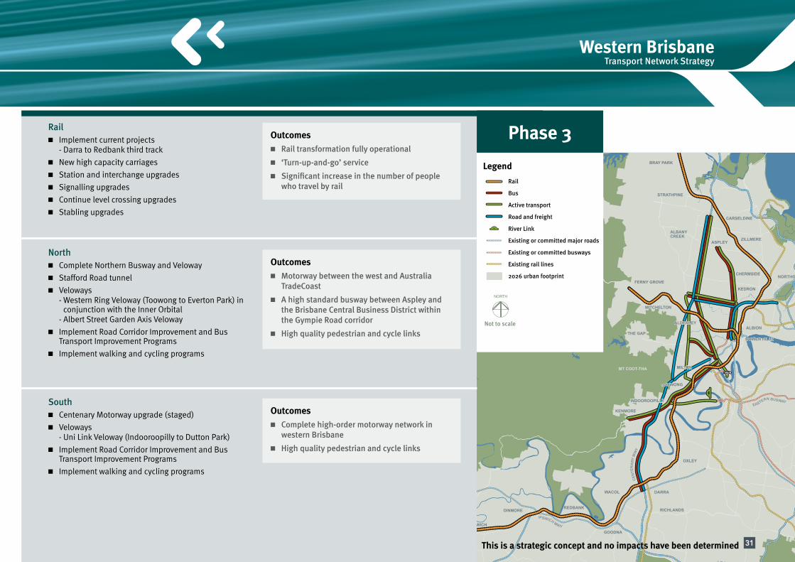
Outcomesn Rail transformation fully operational
n ‘Turn-up-and-go’ service
n Significant increase in the number of people who travel by rail
Outcomesn Motorway between the west and Australia
TradeCoast
n A high standard busway between Aspley and the Brisbane Central Business District within the Gympie Road corridor
n High quality pedestrian and cycle links
Outcomesn Complete high-order motorway network in
western Brisbane
n High quality pedestrian and cycle links
This is a strategic concept and no impacts have been determined
Phase 3Railn Implement current projects - Darra to Redbank third trackn New high capacity carriagesn Station and interchange upgradesn Signalling upgradesn Continue level crossing upgradesn Stabling upgrades
Northn Complete Northern Busway and Velowayn Stafford Road tunneln Veloways - Western Ring Veloway (Toowong to Everton Park) in
conjunction with the Inner Orbital - Albert Street Garden Axis Velowayn Implement Road Corridor Improvement and Bus
Transport Improvement Programsn Implement walking and cycling programs
Southn Centenary Motorway upgrade (staged)n Veloways - Uni Link Veloway (Indooroopilly to Dutton Park)n Implement Road Corridor Improvement and Bus
Transport Improvement Programsn Implement walking and cycling programs
31

Making better use of existing assetsThis strategy commits to making better use of existing rail and road assets and preserved corridors before investing in expensive network expansion.
Effective and efficient corridorsThe development of an effective transport network enables road corridor space to be used for efficient public transport priority and community outcomes.
Improving accessibilityInvesting in a balanced public transport and road network improves accessibility to and from western Brisbane. It also improves accessibility to the Brisbane Central Business District, the Australia TradeCoast (Port of Brisbane and Brisbane Airport) and activity centres.
Supporting a denser and more sustainable cityProjects with strong synergies and opportunities to benefit redevelopment and urban regeneration would be packaged in major corridors such as the North West Transport Corridor and Gympie Road.
Flexibility for managing uncertaintyThe strategy creates a flexible network that manages future uncertainties. For example, the transformation of public transport would provide for strong growth in the Western Corridor as well as employment growth in the Brisbane Central Business District. It would also respond to rising transport costs by providing sufficient capacity to cater for a major shift to public transport.
Benefits of the strategy
32

Western Brisbane Transport Network Strategy
Protecting the environmentThe strategy would assist in meeting the climate change challenge. It would also support the Regional Plan in protecting the non-urban areas of South East Queensland from inappropriate development.
Higher urban densities and mixed land use would result in shorter average trip lengths and more sustainable outcomes. This is in contrast to the pattern of low density residential developments that currently dominate growth areas.
Managing congestionThis strategy would assist in managing road congestion and reducing public transport travel times and overcrowding.
33