Embed Size (px)
Citation preview

WESTERN-CARIBBEAN Tectonic Deformations as
Recorded in the Cuban Foldbelt
ITURRALDE-VINENT, Manuel A.Museo Nacional de Historia Natural, Obispo no. 61,
Plaza de Armas, La Habana 10100 Cuba, [email protected]

Many tectonic elements which today built-up the Cuban foldbelt, originally where part of the Mesozoic North American passive margins and the Proto-Caribbean and Caribbean crusts.
They are represented by the Bahamian-North Cuban foldbelt, the Cuban Southwestern Terranes and the Northern Ophiolites.

Nueva Gerona
La Habana
Pinar del Rio
Matanzas
Cienfuegos
Santa Clara
Trinidad
Camaguey
Holguin
Santiago de Cuba
85°W 84°W 83°W 82°W 81°W 80°W 79°W 78°W 77°W 76°W 75°W 74°W
85°W 84°W 83°W 82°W 81°W 80°W 79°W 78°W 77°W 76°W 75°W 74°W
20°N 20°N
21°N 21°N
22°N 22°N
23°N 23°N
0 100 200 KM
Bahamian margin
Yucatán margin
Guaniguanicoterrane
Pinosterrane Escambray
terrane
Asunciónterrane
Gibara
Cubitas
Camaján
The North American continental margin units crops out along the northern half of the island (Bahamian borderland) and as the Cuban Southwestern terranes (Mayan borderland).
Bahamian borderland
Mayan (Yucatan) borderland

Nueva Gerona
La Habana
Pinar del Rio
Matanzas
Cienfuegos
Santa Clara
Trinidad
Camaguey
Holguin
Santiago de Cuba
85°W 84°W 83°W 82°W 81°W 80°W 79°W 78°W 77°W 76°W 75°W 74°W
85°W 84°W 83°W 82°W 81°W 80°W 79°W 78°W 77°W 76°W 75°W 74°W
20°N 20°N
21°N 21°N
22°N 22°N
23°N 23°N
0 100 200 KM
Bahamian margin
Yucatán margin
Guaniguanicoterrane
Pinosterrane Escambray
terrane
Asunciónterrane
Gibara
Cubitas
Camaján
In the sections of the Bahamian borderland there is no record of Mesozoic tectonic deformation or regional metamorphism.
Deformation and very low degree of metamorphism took place only during the Early Tertiary (Paleocene-Eocene).

The Mesozoic stratigraphy of both the Guaniguanico and Escambray terranes are very similar, but the Pinos terrane differ in representing a more continental-ward set of siliciclastic and carbonate rocks.
An important distinction in the Mesozoic geological history of these terranes is the age of their tectonic deformations and metamorphism.
Nueva Gerona
La Habana
Pinar del Rio
Matanzas
Cienfuegos
Santa Clara
Trinidad
Camaguey
Holguin
Santiago de Cuba
85°W 84°W 83°W 82°W 81°W 80°W 79°W 78°W 77°W 76°W 75°W 74°W
85°W 84°W 83°W 82°W 81°W 80°W 79°W 78°W 77°W 76°W 75°W 74°W
20°N 20°N
21°N 21°N
22°N 22°N
23°N 23°N
0 100 200 KM
Bahamian margin
Yucatán margin
Guaniguanicoterrane
Pinosterrane Escambray
terrane
Asunciónterrane
Gibara
Cubitas
Camaján
In the Guaniguanico terrane there is no record of Mesozoic tectonic deformation or regional metamorphism. Deformation took place during Paleocene and early Middle Eocene.
The Escambray and Pinos terranes suffered deformation and metamorphism during the Cretaceous. K-Ar datings in these terranes record thermal events at the end of the Cretaceous (Pinos 78 - 65 Ma; Escambray 85 - 65 Ma). Ar-Ar and U-Pb dating record ages around 100 Ma.

The deformations of the North American continental margin took place in progression from Cretaceous to Late Eocene.
Nueva Gerona
La Habana
Pinar del Rio
Matanzas
Cienfuegos
Santa Clara
Trinidad
Camaguey
Holguin
Santiago de Cuba
85°W 84°W 83°W 82°W 81°W 80°W 79°W 78°W 77°W 76°W 75°W 74°W
85°W 84°W 83°W 82°W 81°W 80°W 79°W 78°W 77°W 76°W 75°W 74°W
20°N 20°N
21°N 21°N
22°N 22°N
23°N 23°N
0 100 200 KM
Cretaceous
Paleocene-Middle Eocene
Guaniguanicoterrane
Pinosterrane Escambray
terrane
Asunciónterrane
Gibara
Cubitas
Middle to Upper Eocene
Age of the deformations in the continental margin areas

Bahamas
Yucatán
Caribbean
Gulf of Mexico
South America
Guaniguanico
PinosEscambray
POSSIBLE RESTORED POSITION OF THE CUBAN TERRAINS
BAHAMAS

The deformations along the components of the Cuban Foldbelt have some important implications:
It has been proposed that these deformations record the interaction between the North American Plate (NOAM) and the Caribbean Plate (CARIB). If this is so, them:
1. The oldest deformations are recorded in the Pinos and Escambray terranes, suggesting that they were the first to interact with CARIB.
2. The youngest deformations are identified along the Guaniguanico terrane and the Bahamian borderland, recording the so called CARIB “collision” with the Bahamas.

Cuban ophiolites
Within the Northern Cuban Ophiolites occur inclusions of HP/LT metamorphic rocks, including metasedimentary ones,
whose K-Ar age range from 126±9.6 - 67 ±10.4 Ma.

Nueva Gerona
La Habana
Pinar del Rio
Matanzas
Cienfuegos
Santa Clara
TrinidadCiego de Avila
Cabaiguan
Florida
Camaguey
Victoria de las Tunas
Holguin
Guantanamo
Santiago de Cuba
85°W 84°W 83°W 82°W 81°W 80°W 79°W 78°W 77°W 76°W 75°W 74°W
85°W 84°W 83°W 82°W 81°W 80°W 79°W 78°W 77°W 76°W 75°W 74°W
20°N 20°N
21°N 21°N
22°N 22°N
23°N 23°N
N
0 100 200 KM
Yucatán borderland
Northern Ophiolites
Bahamian borderland
Volcanic arc (K-Cretaceous, P-Paleogene)K P
Pinos terrane
Escambray terrane
Guaniguanicoterrane
P-Volcanic arc
K-Volcanic arc
K-Volcanic arc
Cretaceous arcs
Paleogene arcc
Deformations within the
Volcanic Arcs
Within the sections of the volcanic arcs can be recorded a number of regional deformational events. These deformations took place during the Aptian, Coniacian-Santonian, late Campanian, Maastrichtian-Paleocene and Middle Eocene.
Every deformation is associated with local hiata, conglomerates, changes in the geochemistry of the magmas, and with plutonite emplacement -sometimes of very large scale, as during the latest Cretaceous and the Middle-Late Eocene.

The deformations within the Northern Ophiolites and the Volcanic Arcs have additional implications:
1. Is quite probably that these deformations record intraplate tectonic events of the Caribbean (CARIB) and Proto-Caribbean Plates (P-CARIB).
2. The fact that P-CARIB elements (Northern ophiolites) suffered deformations since the Early Cretaceous, suggest that this plate had had a rather complicate history.
3. The punctuated deformations recorded within the volcanic arcs since the Aptian, imply that the Arc terranes were deformed way before the “collision” with the Bahamas, also probably due to intraplate events.

Cenozoic paleogeographic evolution of the Caribbean

-90Þ -85Þ -80Þ -75Þ
15Þ
20Þ
25Þ
Bahamas Platform
Florida Platform
Yucatan Platform
?
Chixulub
Jamaica
Cuban Platform
Late Cretaceous paleogeography of the western Caribbean
Cretaceous deformationand metamorphism
PINOSTERRANE
ESCAMBRAYTERRANE
NORTHERNOPHIOLITES
-90Þ -85Þ -80Þ -75Þ
15Þ
20Þ
25Þ
Bahamas Platform
Florida Platform
Yucatan Platform
Chixulub
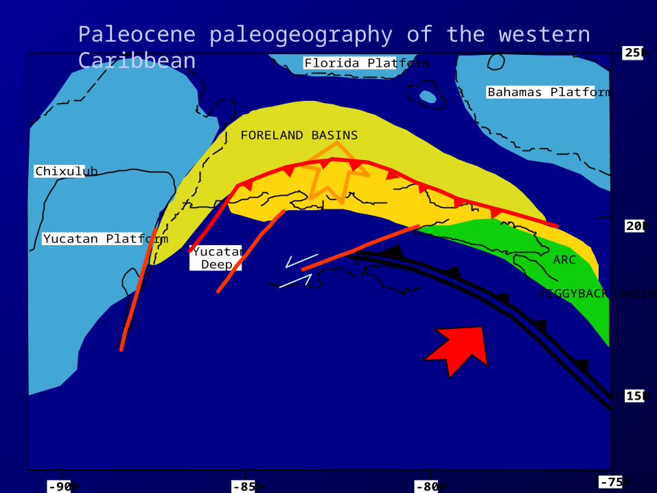
FORELAND BASINS
PIGGYBACK BASIN
ARCYucatan
Deep
Paleocene paleogeography of the western Caribbean

-90Þ -85Þ -80Þ -75Þ
15Þ
20Þ
25Þ
Bahamas Platform
Florida Platform
Yucatan Platform
Chixulub
w Jamaica
FORELAND BASINS
PIGGYBACK BASIN
ARC
Eocene deformation of the western Caribbean
Progressive deformationof the continental margin
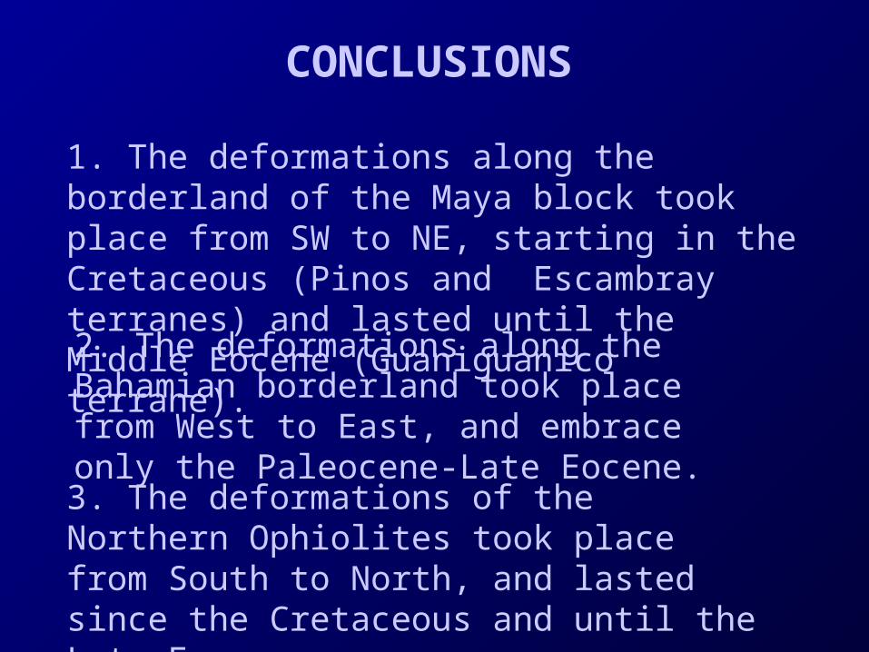
CONCLUSIONS
1. The deformations along the borderland of the Maya block took place from SW to NE, starting in the Cretaceous (Pinos and Escambray terranes) and lasted until the Middle Eocene (Guaniguanico terrane).
3. The deformations of the Northern Ophiolites took place from South to North, and lasted since the Cretaceous and until the Late Eocene.
2. The deformations along the Bahamian borderland took place from West to East, and embrace only the Paleocene-Late Eocene.

4. These facts corroborate the Plate Tectonic models which require that the present Caribbean Plate originated West of Pangaea, to became intercalated between North and South America since the Cretaceous.
5. Nevertheless, the same results also represent a problem for the most common Caribbean models, because none of them explain why the Bahamian borderland is deformed only during the Paleogene, while the ophiolites for a long period of time since the Early Cretaceous.
This is a contribution to IGCP Project 433:
"Caribbean Plate Tectonics"
Project 433 Caribbean Plate