Embed Size (px)
Citation preview
Western Rail Yard Environmental Impact Statement (EIS) Draft Scope of Work
INTRODUCTION The Metropolitan Transportation Authority (MTA) and the New York City Planning Commission (CPC) are serving as co-lead agencies for the environmental review of a proposed mixed-use development over the western section (“Western Rail Yard”) of the MTA-Long Island Rail Road (LIRR) John D. Caemmerer West Side Yard in Manhattan. The mixed-use development is expected to include commercial (retail, office, and/or hotel) space, residential units (both market rate and affordable), a public school, other community facilities, open space, and parking (“Proposed Project”). The principal actions to be analyzed (collectively, the “Proposed Actions”) include: (1) the lease of, with option to purchase, the air space over the Western Rail Yard by MTA to a development entity selected by MTA to carry out such mixed-use development; (2) zoning map and text amendments and accessory parking special permits by the City of New York pursuant to the Uniform Land Use Review Procedure (ULURP); (3) the establishment of new legal grades in West 33rd Street between Eleventh and Twelfth Avenues; (4) the site selection for a PS/IS school on the Western Rail Yard; (5) the partial release of MTA’s interest in certain property located at the intersection of Ninth Avenue and West 54th Street in Manhattan to the City; and (6) disposition and other land use approvals for this MTA parcel and another parcel located near the intersection of Tenth Avenue and West 48th Street in order to facilitate the development of affordable housing at these two sites.
Pursuant to the requirements of the New York State Environmental Quality Review Act (SEQRA) and City Environmental Quality Review (CEQR), the co-lead agencies have determined that the Proposed Actions require the preparation of an Environmental Impact Statement (EIS). In accordance with SEQRA/CEQR, the co-lead agencies are initiating a process to define the scope of the Draft EIS (DEIS). As a first step in that process, they have prepared this Draft Scoping Document for the DEIS and have made it available to agencies and the public for review and comment. A Final Scoping Document will be prepared after consideration of public comments.
A public meeting has been scheduled on October 2, 2008 to provide a forum for public comments on this Draft Scoping Document. The public meeting will be held at the Jacob K. Javits Convention Center, 655 West 34th Street (enter on Eleventh Avenue), Room IA-03-05. The scoping meeting will include both afternoon and evening sessions. The afternoon session will be held between 2:00 and 5:00 PM. The evening session will be held between 6:00 PM and 9:00 PM, and will extend later, as needed, to accommodate all those who register to speak prior to 9:00 PM.
1
Western Rail Yard
Written comments on the Draft Scoping Document will be accepted by the co-lead agencies until the close of business on Tuesday, October 14, 2008. Written comments should be addressed to:
New York City Planning Commission Attention: Robert Dobruskin, AICP Director EARD, NYCDCP 22 Reade Street, Room 4E New York, New York 10007 Or emailed to: [email protected]
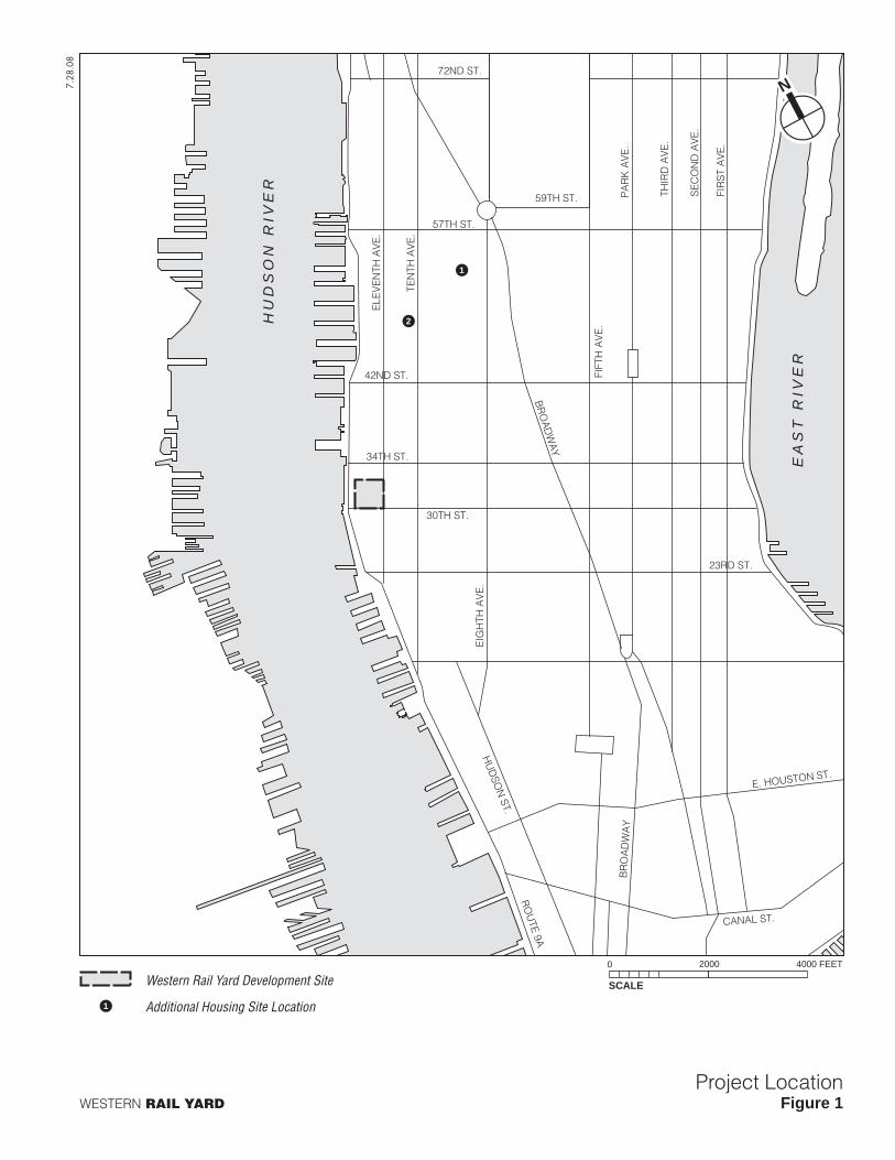
IDENTIFICATION OF THE PROPOSED ACTIONS An EIS will be prepared pursuant to SEQRA and CEQR by CPC and MTA as co-lead agencies to assess the potential significant adverse environmental impacts of the Proposed Actions. As shown in Figure 1, the Proposed Actions involve three sites—the Western Rail Yard (“Development Site”), comprising approximately 13 acres, as well as two “Additional Housing Sites”: a site near Tenth Avenue and West 48th Street, and the other at Ninth Avenue near West 54th Street. The Development Site is bounded by Eleventh Avenue to the east, West 30th Street to the south, Twelfth Avenue to the west, and West 33rd Street to the north.
Zoning and other land use actions would be required to allow for the proposed development at all three project sites. For the Development Site this includes amending the zoning map and the text of the zoning resolution, the grant of a special permit for accessory parking use, changes to the City Map, and site selection for the public school. For the Additional Housing Sites, the zoning and other land use actions include a text amendment to the zoning resolution for a new special permit, the grant of special permits under this text amendment and existing provisions of the zoning resolution, and authorization for disposition of these sites for affordable housing. A description of the anticipated actions and approvals is provided below.
As owner of the Development Site, MTA would enter into a lease of, with option to purchase, air space with the conditionally designated developer, RG WRY LLC (a joint venture of Related Companies and Goldman Sachs and referred to subsequently as the “Developer”), to carry out the development described below on the Development Site. For the Additional Housing Sites, MTA would release its partial interest in the West 54th Street site to the City of New York.
PURPOSE AND NEED
PURPOSE OF THE PROPOSED ACTIONS
As explained more fully below, developing the air space above the Development Site has been a long-standing goal of both the City and MTA.
Encouraging the development of new residential, commercial, public school, and open space uses within a largely underutilized area of Far West Midtown is intended to enhance the vitality of the Hudson Yards area, build the City’s tax base, and help to create a new 24-hour neighborhood that complements the adjacent built-up areas of Midtown and Chelsea and the emerging development in West Chelsea and the Hudson Yards area. The net proceeds from the disposition of the Development Site will be an important source of funds to support the MTA’s
2
FIFT
H A
VE
.
EIG
HTH
AV
E.
BR
OA
DW
AY
59TH ST.
72ND ST.
57TH ST.
42ND ST.
34TH ST.
30TH ST.
TEN
TH A
VE
.
ELE
VE
NTH
AV
E.
CANAL ST.
E. HOUSTON ST.
HU
DSO
N ST.
RO
UTE 9A
BR
OA
DW
AY
23RD ST.
HU
DS
ON
RIV
ER
EA
ST
RIV
ER
PA
RK
AV
E.
THIR
D A
VE
.
FIR
ST
AV
E.
SE
CO
ND
AV
E.
BPC
FRANKFORT ST.
7.28
.08
WESTERN RAIL YARD
N
SCALE
0 2000 4000 FEET
Project LocationFigure 1
Western Rail Yard Development Site
Additional Housing Site Location1
1
2
Draft Scope of Work
mission of providing safe, reliable, and convenient public transportation in a cost effective manner.
Development of the Development Site is also important to accommodate the projected growth in population and workers in Manhattan and the region. The Development Site is open, largely below grade, and surrounded primarily by concrete walls. The Proposed Actions would provide a mixed-use development connected to and integrated with the surrounding neighborhoods and open space networks, including the High Line Park, Hudson River Park, the future open space on the eastern portion of the West Side Yard between Tenth and Eleventh Avenues (the “Eastern Rail Yard”), and the future Hudson Park and Boulevard. The affordable housing component of the Proposed Actions, including the development at the two Additional Housing Sites, would help meet the need for increased affordable housing for New York City residents and workers.
SPECIFIC CITY GOALS AND OBJECTIVES
The City’s goals for the Proposed Actions include:
• Furthering the redevelopment and revitalization of the Far West Midtown area in accordance with sound planning objectives;
• Developing a mix of uses on the Development Site that will contribute to the economic, social, and recreational life of the Far West Midtown area and the City;
• Creating affordable housing to support the future growth of the City as a place for residents of all economic levels;
• Providing new open space and enhanced connections to existing and proposed open space;
• Facilitating the redevelopment of the High Line;
• Developing the Development Site and the Additional Housing Sites in accordance with sustainable design principles;
• Providing opportunities for jobs and economic development; and
• Providing opportunities for world class architecture.
SPECIFIC MTA GOALS AND OBJECTIVES
The MTA’s goals for the Proposed Action include:
• Maximizing value and revenue for the MTA’s capital financial plan;
• Maintaining safe, continuous, and uninterrupted LIRR operations at the Development Site; and
• Creating a site plan and buildings that meet standards of excellence in architecture, urban design, and sustainability.
PLANNING PROCESS
HISTORY OF SITE AND PLANNING BACKGROUND
The proposal to redevelop the Development Site is the culmination of many years of planning and proposals for redeveloping the entire John D. Caemmerer West Side Yard.
3
Western Rail Yard
The West Side Yard, like much of the Far West Side, has long been used for rail and transportation facilities, starting in the mid to late 1800s, when the Hudson River Railroad first developed a rail depot on the site. Subsequently, the Hudson River Railroad merged with the New York Central Railroad, which used the West Side Yard as a freight depot that gradually grew to become a major freight terminal in the early 20th century. The current configuration of the Eleventh Avenue Viaduct (which separates the eastern and western portions of the West Side Yard) and the High Line were created in the 1930s as part of the West Side Improvement Project. The elevated Miller Highway was also built above Twelfth Avenue as part of that project. By the 1970s, freight operations fell into disuse, and the Triborough Bridge and Tunnel Authority (TBTA), an affiliate of the MTA, acquired the site in 1980 from Consolidated Rail Corporation, an affiliate of Penn Central Transportation Company. The TBTA redeveloped the West Side Yard in 1986, in tandem with the development of the Jacob K. Javits Convention Center, as a storage and maintenance complex for the LIRR’s electric commuter car fleet. TBTA also designed the Development Site to allow for future development above its facilities, and tracks were spaced to accommodate columns to support air rights development without interrupting use of the yard as a rail facility.
The initial impetus for accommodating a future overbuild over the Development Site was a proposal to relocate Madison Square Garden there. Although Madison Square Garden ultimately decided to renovate its existing structure rather than move, the planning effort identified a broad range of public benefits that could result from the development of the area above the Development Site, including new housing, parks and waterfront recreation, support uses to enhance the then relatively new Jacob K. Javits Convention Center’s marketability, and office space to accommodate large employers who require large development sites.
More recently, the area near the Development Site has been the subject of various planning, rezoning, and redevelopment efforts by the City, the MTA, and other entities. In 2005, the Eastern Rail Yard was rezoned under the 2005 Hudson Yards rezoning to C6-4 to accommodate high density, mixed use development. The 2005 Hudson Yards rezoning project included a major rezoning of the entire Hudson Yards area, including the Eastern Rail Yard, to accommodate a mix of uses and densities throughout the Far West Side, the provision of new open space, and an extension of the No. 7 Subway Line. In connection with the Hudson Yards project, the Development Site, which was not rezoned, was the proposed location for a multi-use stadium for the New York Jets, a proposal that was ultimately not approved and was later withdrawn.
REQUESTS FOR PROPOSALS
In July 2007, the MTA issued a request for proposals (RFP) for the lease of, with option to purchase, air space and related real property interests for development over the Development Site. (A separate RFP was also issued by the MTA for development of the Eastern Rail Yard in accordance with applicable zoning.) As noted above, the primary objectives of the MTA are to maximize revenue for its capital plan and to assure safe, uninterrupted LIRR service at the Development Site. A further goal described in the RFP is to promote excellence in architecture, urban design, and sustainability in keeping with the City’s vision for the economic development and revitalization of the Far West Midtown/Hudson Yards area.
The RFP contained Design Guidelines (“guidelines”) for proposals for the Western Rail Yard. The guidelines were developed by the City (including the New York City Department of City Planning [DCP]), the Hudson Yards Development Corporation (HYDC), and MTA. The guidelines contemplated a density of a 10 floor area ratio (FAR), plus density bonuses related to
4
Draft Scope of Work
the provision of permanently affordable housing and a floor area allowance for a school. The guidelines stated several principles that were to guide the development of the proposals. The development should include a variety of uses and should be integrated into the surrounding neighborhoods. The buildings should be organized around a central open space, and there should be visual connections to the High Line Park and to Hudson River Park. The building heights should vary. The streetscape should be continuous and provide a varied pedestrian experience.
On October 11, 2007, MTA received proposals for the Development Site from five real estate development firms. After a request to all proposers, the MTA received supplemental submissions from four of the five proposers on February 26, 2008. The proposals were evaluated over several months by a selection committee comprising representatives of the MTA and HYDC. All the proposals adhered to the basic mix of uses (residential, commercial, retail, public school, and open space) specified in the RFP, and generally reflected the design guidelines referred to in the RFP that had been developed by the MTA and HYDC in consultation with DCP.
After negotiations with several of the proposers, the MTA reached a conditional designation agreement with the Developer for the development of plans for the Development Site on May 19, 2008.
PUBLIC OUTREACH
In advance of the RFP, the MTA and HYDC held workshops, forums, presentations, and meetings in consultation with various City and State agencies, civic groups, and other organizations. This consultation took place for over a year and included such groups as a Community Advisory Committee, a Technical Advisory Committee, New York City Police Department, New York City Fire Department, New York City and New York State Departments of Transportation, New York City Department of Parks and Recreation (DPR), Community Board 4, the Manhattan Borough President, the Hell’s Kitchen Neighborhood Association, the Real Estate Board of New York, Friends of the High Line, Friends of the Hudson River Park Trust, the American Institute of Architects, the American Planning Association, the Regional Plan Association, and the Convention Center Development Corporation.
After the RFP was issued, to ensure that public input informed the developer selection process, MTA hosted a public exhibition of the five proposals received in response to the Western Rail Yard RFP. The exhibit was open to the public from 8 AM to 8 PM from November 19, 2007 through December 3, 2007. The exhibit featured models and other presentation materials prepared by each of the five development teams. Public comments were accepted via comment cards at the exhibit and online at the MTA website, which also provided links to the development teams’ websites, where additional material describing the proposals could be viewed. A broad range of comments received from Community Board 4, elected officials, civic and community groups, and private individuals, provided recommendations relating to the development of the Western Rail Yard.
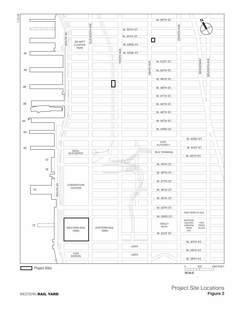
PROJECT DESCRIPTION The Proposed Project includes development at the three project sites. The Proposed Actions would allow for the development of an approximately 6.3-million gross square-foot (5.7 million
5
Western Rail Yard
zoning square feet1) mixed-use project at the Development Site and would also allow for the development of affordable housing units and local retail space at two additional housing sites located to the north of the Development Site (see Figure 2). The following provides a description of the proposal for each project site.
DESCRIPTION OF THE PROJECT SITES
DEVELOPMENT SITE
The approximately 13-acre Development Site is bounded by Eleventh Avenue to the east, West 33rd Street to the north, Twelfth Avenue to the west, and West 30th Street to the south. The Development Site, along with the Eastern Rail Yard immediately adjacent to the east, comprise the West Side Yard, which is an electrified and signalized train yard with 30 storage tracks for LIRR trains.
The West Side Yard allows for arriving peak period LIRR trains in Penn Station to continue west after discharging passengers. It also allows for peak period LIRR evening trains to proceed from the yard to the platform in Penn Station and promptly board eastbound passengers. This mid-day storage capability shortens platform dwell times, and reduces the number of conflicts in traffic patterns, effectively allowing for more trains to move through Penn Station.
The West Side Yard contains several LIRR facilities that support the daily operation of the LIRR, including: a railroad interior cleaning facility, a yard operations building, a transportation building, an emergency facilities building, and storage. The LIRR must have continuous access to the LIRR train yard and facilities to support operational needs in the West Side Yard. Below track level, the West Side Yard also hosts other existing and planned subsurface transportation facilities, such as the Amtrak North River Tunnels and the Amtrak North Access Tunnel. In addition, New Jersey Transit has proposed an alignment for its Access to the Region’s Core Access to the Region’s Core (ARC) project that would place subsurface tunnels to the south and east of the Development Site.
The southern portion of the Development Site, between West 30th Street and the approximate location of West 31st Street, includes land (“terra firma”) that is not occupied by LIRR operations. A portion of the terra firma is currently occupied on a month-to-month basis by a bus operator and New York City Department of Sanitation. These tenants would vacate the Development Site prior to construction of the Proposed Project.
The High Line runs along the western edge of the Development Site along Twelfth Avenue, and along West 30th Street along the southern boundary of the Development Site. Completed in 1934 as part of the West Side Improvement Project, the High Line replaced the New York Central freight railroad along West Street and Tenth Avenue to eliminate dangerous traffic conflicts at grade. The High Line is now an unused, freight railroad viaduct on the west side of Manhattan, extending from Gansevoort Street to West 34th Street. To the south of the Development Site, the High Line is currently being renovated as a park to provide a new linear
1 The zoning floor area of a building is the gross floor area above grade less space devoted to mechanical
uses, loading and parking below a height of 23 feet above curb level, and additional areas noted in the New York City Zoning Resolution. For the Development Site, as part of the Proposed Actions, above-grade space used for a PS/IS school also would not count as zoning square footage.
6
DE WITTCLINTON
PARK
W. 56TH ST.
W. 55TH ST.
W. 54TH ST.
NIN
TH A
VE.
TEN
TH A
VE.
ELEV
ENTH
AVE
.
W. 53RD ST.
W. 52ND ST.
W. 51ST ST.
W. 50TH ST.
W. 49TH ST.
W. 48TH ST.
W. 47TH ST.
W. 46TH ST.
W. 45TH ST.
W. 44TH ST.
W. 43RD ST.
W. 42ND ST.
EIG
HTH
AVE
.
SEVE
NTH
AVE
.
BRO
ADW
AY
W. 41ST ST.
W. 40TH ST.
W. 39TH ST.
W. 38TH ST.
W. 36TH ST.
W. 37TH ST.
W. 35TH ST.
W. 34TH ST.
W. 33RD ST.
W. 31ST ST.
W. 30TH ST.
W. 29TH ST.
W. 28TH ST.
RO
UTE
9A
RO
UTE
9A
76
81
83
84
86
88
90
76
72
82
78
79
83
84
86
88
90
92
CONVENTIONCENTER
WESTERN RAILYARD
EASTERN RAILYARD
USPS
USPS
QUILLBUS DEPOT
PORTAUTHORITY
BUS TERMINAL
MADISONSQUAREGARDEN/
PENNSTA
TWOPENNPLAZA
ONE PENN PLAZA
CONEDISON
7.22
.08
N
FARLEYBLDG
WESTERN RAIL YARD
Project Site LocationsFigure 2
Project SitesSCALE
0 500 1000 FEET
Draft Scope of Work
passive open space resource stretching south from West 30th Street, primarily between Tenth and Eleventh Avenues.
ADDITIONAL HOUSING SITES
In addition to the affordable housing proposed at the Development Site, the Proposed Actions would also provide for the development, by sponsors to be selected by the City at a later date, of affordable housing at two sites located northeast of the Development Site—near the west side of Tenth Avenue between West 48th and 49th Streets and along the east side of Ninth Avenue between West 53rd and 54th Streets. The City has proposed to provide $40 million in subsidy for the construction of affordable housing at these sites.
The Tenth Avenue site, which is located near the west side of Tenth Avenue between West 48th and 49th Streets, is approximately three quarters of a mile away from the Development Site. This site is located within the right-of-way airspace for Amtrak’s Northeast Corridor Line that runs through the western portion of Block 1077, Lot 29. The Proposed Actions would require the construction of a platform to facilitate development over the Amtrak rail line.
The Ninth Avenue site, which is located at the southeast corner of Ninth Avenue and West 54th Street, is approximately one mile from the Development Site and about a third of a mile away from the Tenth Avenue site. This site is within the western portion of Block 1044, Lot 3, which contains a paved surface parking lot associated with MTA/New York City Transit (NYCT) facility located on the parcel.
DESCRIPTION OF PROPOSED ACTIONS
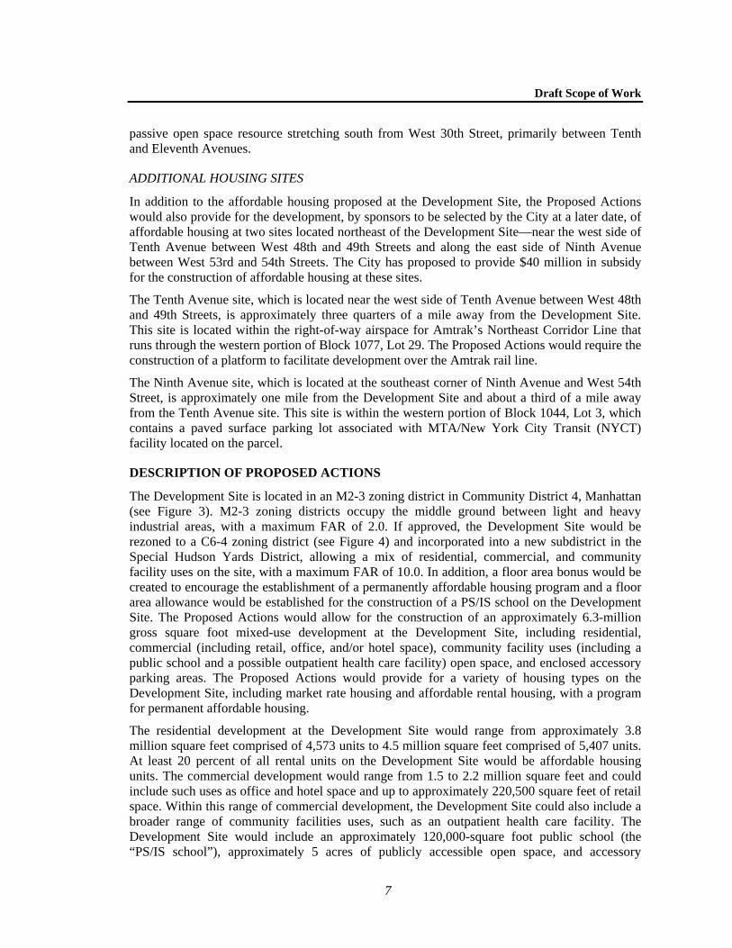
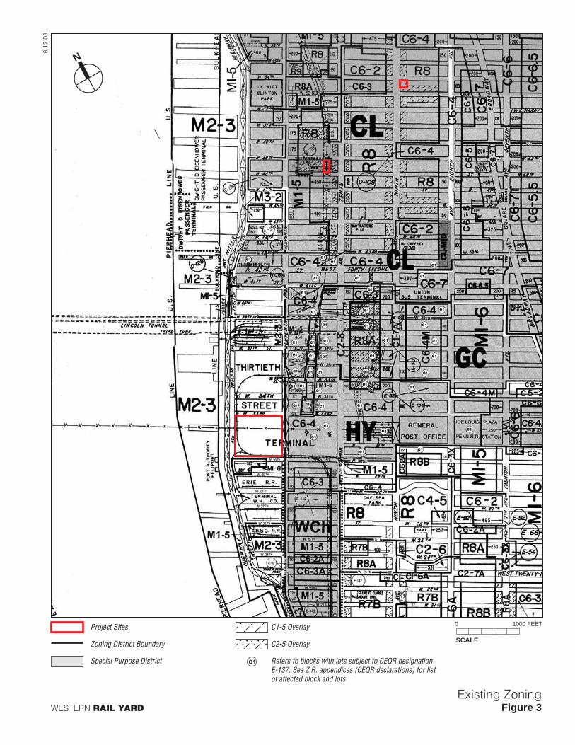
The Development Site is located in an M2-3 zoning district in Community District 4, Manhattan (see Figure 3). M2-3 zoning districts occupy the middle ground between light and heavy industrial areas, with a maximum FAR of 2.0. If approved, the Development Site would be rezoned to a C6-4 zoning district (see Figure 4) and incorporated into a new subdistrict in the Special Hudson Yards District, allowing a mix of residential, commercial, and community facility uses on the site, with a maximum FAR of 10.0. In addition, a floor area bonus would be created to encourage the establishment of a permanently affordable housing program and a floor area allowance would be established for the construction of a PS/IS school on the Development Site. The Proposed Actions would allow for the construction of an approximately 6.3-million gross square foot mixed-use development at the Development Site, including residential, commercial (including retail, office, and/or hotel space), community facility uses (including a public school and a possible outpatient health care facility) open space, and enclosed accessory parking areas. The Proposed Actions would provide for a variety of housing types on the Development Site, including market rate housing and affordable rental housing, with a program for permanent affordable housing.
The residential development at the Development Site would range from approximately 3.8 million square feet comprised of 4,573 units to 4.5 million square feet comprised of 5,407 units. At least 20 percent of all rental units on the Development Site would be affordable housing units. The commercial development would range from 1.5 to 2.2 million square feet and could include such uses as office and hotel space and up to approximately 220,500 square feet of retail space. Within this range of commercial development, the Development Site could also include a broader range of community facilities uses, such as an outpatient health care facility. The Development Site would include an approximately 120,000-square foot public school (the “PS/IS school”), approximately 5 acres of publicly accessible open space, and accessory
7
8.12
.08
WESTERN RAIL YARDExisting Zoning
Figure 3
N
SCALE
0 1000 FEETProject Sites
Zoning District Boundary
Special Purpose District
C1-5 Overlay
C2-5 Overlay
Refers to blocks with lots subject to CEQR designation E-137. See Z.R. appendices (CEQR declarations) for list of affected block and lots
C6-4
HY
8.12
.08
WESTERN RAIL YARDProposed Zoning
Figure 4
N
SCALE
0 1000 FEETProject Sites
Zoning District Boundary
Special Purpose District
C1-5 Overlay
C2-5 Overlay
Refers to blocks with lots subject to CEQR designation E-137. See Z.R. appendices (CEQR declarations) for list of affected block and lots
Western Rail Yard
parking. The number of accessory parking spaces for the Development Site has not been determined at this time. The terra firma portion of the site could accommodate approximately 500 spaces (with more spaces, estimated by the Developer to be approximately 350, if a below grade level could be constructed); any additional spaces proposed for the platform would require review by MTA, LIRR, and other relevant agencies. Accessory parking would also require issuance of a special permit by CPC as well as MTA approval.
At the Development Site, approximately two-thirds of the development would be constructed over the LIRR rail yard and would require the construction of a platform. The remainder of the development would be on terra firma. Some of the existing LIRR on-site facilities would be temporarily relocated to facilitate construction. Although there would be temporary or periodic track outages during construction (described in more detail below), there would not be any disruption to LIRR passenger service.
The Developer proposes a number of sustainable, green components for the Development Site to promote water and energy conservation: stormwater would be captured off of building roofs and used for other building uses; buildings without stormwater capture would employ green roof technology where feasible; water conserving dishwashers and clothes washers would be installed in the residential units; and water conserving toilets and faucets would be installed in all buildings. In addition, other sustainable measures to be considered include covered and secure bike storage and commitment to Leadership in Energy and Environmental Design (LEED) for New Construction certification for all buildings. During construction the Developer would institute diesel emission reduction measures for construction equipment and non-road vehicles and institute practices and measures to minimize the discharge of untreated concrete-contaminated water.
The Proposed Actions also include the development of affordable housing and local retail at the Additional Housing sites. Although the exact development program for these sites has not been determined at this time, as described earlier, the City has agreed to provide $40 million in subsidy for the construction of affordable housing at these sites.
SITE PLANNING, BULK, AND MASSING
DEVELOPMENT SITE
The Development Site is proposed to be rezoned to a C6-4 zoning district, allowing a mix of residential, commercial, and community facility uses on the site, with a maximum FAR of 10.0. In addition, a floor area bonus would be created to encourage the establishment of a permanently affordable housing program and a floor area allowance would be established to encourage the construction of a PS/IS school on the site. The rezoned site would be incorporated into a new subdistrict in the Special Hudson Yards District, the requirements of which would be generally consistent with the goals of the Western Rail Yard RFP Design Guidelines produced by DCP, HYDC, and the MTA in terms of the amount of density, the uses, and the amount of open space provided. Zoning controls would regulate building envelopes and use; as well as parking, public access areas, streetwall controls, and retail continuity.
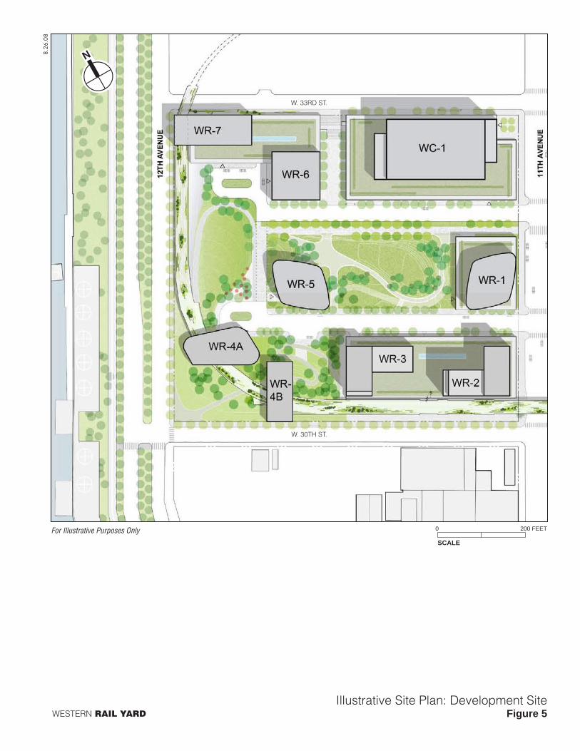
A proposed site plan has been prepared by the Developer consistent with these zoning design guidelines and criteria. This site plan is illustrative and is expected to be modified as project planning proceeds further. As currently contemplated, the site plan includes one commercial building at the northeastern corner of the Development Site and eight mixed-use, primarily residential buildings surrounding open space (see Figure 5), with ground floor retail and/or community facilities. It is anticipated that three residential buildings would be located west of
8
W. 30TH ST.
W. 33RD ST.
8.26
.08
WESTERN RAIL YARD
SCALE
0 200 FEET
Illustrative Site Plan: Development SiteFigure 5
For Illustrative Purposes Only
Draft Scope of Work
the commercial building along West 33rd Street and two mixed-use residential buildings would be located at the southwest portion of the Development Site. The plan currently proposes the PS/IS school in the base of a building, with two residential towers above and ground-floor retail below, in the southeast portion of the Development Site along West 30th Street. Just north of this building another mixed-use residential building is proposed on the Development Site along Eleventh Avenue.
Proposed building massing and heights are intended to reflect a gradual decrease in height and mass descending from Eleventh Avenue and West 33rd Street to Twelfth Avenue and West 30th Street. It is anticipated that the tallest building on the site would be the commercial building at the northeast corner. Taller residential buildings are proposed generally in the eastern and northern portion of the Development Site and shorter residential buildings in the southwest quadrant of the Development Site. It is anticipated that building heights would generally range from approximately 25 to 70 stories.
Current plans propose a northern vehicular driveway accessible from Eleventh Avenue that would align approximately with West 32nd Street. This driveway is intended to be a two-way vehicle lane that would provide passenger side drop off and accessibility to the commercial building and residential buildings on the north side of the site. The driveway would continue west with a cul-de-sac drop off to provide vehicular access to the residential buildings further west. It is anticipated that there would also be a southern vehicular driveway accessible from Eleventh Avenue that aligns approximately with West 31st Street. This would be a two-way vehicular driveway that would provide access to the residential buildings in the western portion of the site in a cul-de-sac drop off, as well as to the retail uses at the base of these buildings.
Approximately 5 acres of open space are currently proposed throughout the site. In the western portion of the Development Site, between the residential buildings to the north and south, a waterfront lawn is proposed that would allow for active and passive recreation and may allow for occasional outdoor events. In the eastern portion of the Development Site, between the PS/IS school and the proposed commercial building, a central open space is proposed with rolling hills, playgrounds, pathways, and benches. A tiered open space is also proposed on the southwest corner of the site leading down from the central open space to street level on West 30th Street and Twelfth Avenue and providing street-level access to Hudson River Park from the Development Site.
The High Line is proposed to be integrated into the overall site plan for the Development Site as a passive open space resource and pedestrian pathway that would also connect with the High Line Park to the south. Access to the High Line is also proposed from the waterfront lawn.
ADDITIONAL HOUSING SITES
Upon completion of the environmental and land use review processes, and the MTA’s entering into a lease, with option to purchase, for the Development Site with the Developer, the New York City Department of Housing Preservation and Development (HPD) would issue RFPs, inviting developers to submit development proposals for the Additional Housing Sites. The RFPs would be in accordance with the Mayor’s New Housing Marketplace Plan, which commits to the new construction or rehabilitation of 165,000 housing units by 2013. Once proposals are submitted, they would be examined in a competitive review process in the areas of planning, finance, and design. Following this process, a developer would be selected, and special permits and any additional land use reviews, as necessary, for development of these sites would be undertaken. For the Tenth Avenue site, the adjacent land fronting on Tenth Avenue is owned by
9
Western Rail Yard
the City and is being used by the Department of Environmental Protection (DEP) for the construction of the Third Water Tunnel project. The RFP for the Tenth Avenue site would be issued after DEP completed its use of the adjacent site for the Third Water Tunnel construction. At the Ninth Avenue site, it is contemplated that the bulk of the site would be made available for affordable housing development, with a portion of the site reserved for use by the MTA.
CONSTRUCTION SEQUENCING
DEVELOPMENT SITE
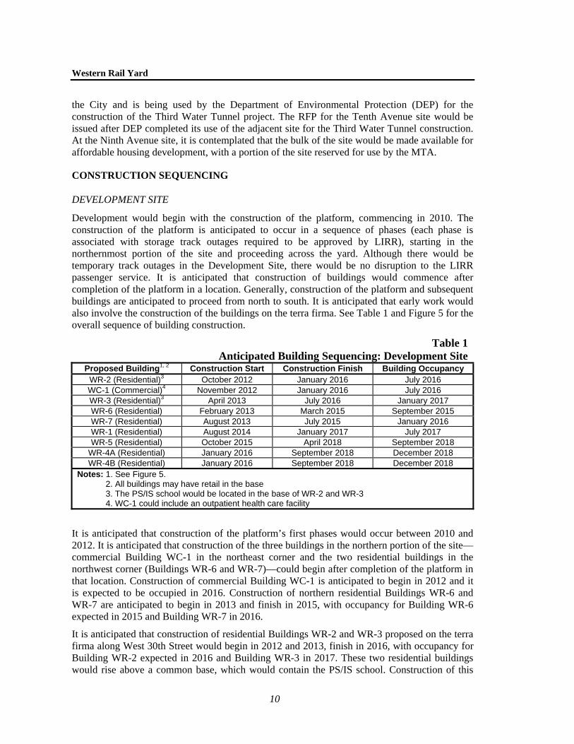
Development would begin with the construction of the platform, commencing in 2010. The construction of the platform is anticipated to occur in a sequence of phases (each phase is associated with storage track outages required to be approved by LIRR), starting in the northernmost portion of the site and proceeding across the yard. Although there would be temporary track outages in the Development Site, there would be no disruption to the LIRR passenger service. It is anticipated that construction of buildings would commence after completion of the platform in a location. Generally, construction of the platform and subsequent buildings are anticipated to proceed from north to south. It is anticipated that early work would also involve the construction of the buildings on the terra firma. See Table 1 and Figure 5 for the overall sequence of building construction.
Table 1Anticipated Building Sequencing: Development Site
Proposed Building1, 2 Construction Start Construction Finish Building OccupancyWR-2 (Residential)3 October 2012 January 2016 July 2016 WC-1 (Commercial)4 November 2012 January 2016 July 2016 WR-3 (Residential)3 April 2013 July 2016 January 2017 WR-6 (Residential) February 2013 March 2015 September 2015 WR-7 (Residential) August 2013 July 2015 January 2016 WR-1 (Residential) August 2014 January 2017 July 2017 WR-5 (Residential) October 2015 April 2018 September 2018
WR-4A (Residential) January 2016 September 2018 December 2018 WR-4B (Residential) January 2016 September 2018 December 2018
Notes: 1. See Figure 5. 2. All buildings may have retail in the base 3. The PS/IS school would be located in the base of WR-2 and WR-3 4. WC-1 could include an outpatient health care facility
It is anticipated that construction of the platform’s first phases would occur between 2010 and 2012. It is anticipated that construction of the three buildings in the northern portion of the site—commercial Building WC-1 in the northeast corner and the two residential buildings in the northwest corner (Buildings WR-6 and WR-7)—could begin after completion of the platform in that location. Construction of commercial Building WC-1 is anticipated to begin in 2012 and it is expected to be occupied in 2016. Construction of northern residential Buildings WR-6 and WR-7 are anticipated to begin in 2013 and finish in 2015, with occupancy for Building WR-6 expected in 2015 and Building WR-7 in 2016.
It is anticipated that construction of residential Buildings WR-2 and WR-3 proposed on the terra firma along West 30th Street would begin in 2012 and 2013, finish in 2016, with occupancy for Building WR-2 expected in 2016 and Building WR-3 in 2017. These two residential buildings would rise above a common base, which would contain the PS/IS school. Construction of this
10
Draft Scope of Work
base would include the core and shell for the PS/IS school, however the timing for the interior construction and opening of the school would be determined by the Department of Education and the School Construction Authority.
It is anticipated that construction of residential Building WR-1 just north of the PS/IS school would begin in 2014 and is expected to be completed and occupied in 2017. The last three residential buildings to be constructed are Buildings WR-5, WR-4A, and WR-4B proposed on the southwestern portion of the Development Site. Residential Building WR-5, to be constructed on the platform, is expected to begin construction in 2015 and is expected to be completed and occupied in 2018. It is anticipated that Buildings WR-4A and WR-4B along West 30th Street would be constructed on terra firma and begin construction in 2016 and are expected to be completed and occupied in 2018. It is anticipated that the proposed open space would be developed in phases associated with the completion of the adjacent buildings. All open space is anticipated to be completed by the end of 2018.
To bring tall pieces of construction equipment into the Development Site from Twelfth Avenue, portions of the High Line on the Development Site may be temporarily removed during construction. These portions of the High Line would be restored in place after construction.
ADDITIONAL HOUSING SITES
Construction of the Ninth Avenue site is expected to be complete in 2016. The RFP for the Tenth Avenue site would be issued after the DEP is finished using the adjacent site for the Third Water Tunnel construction. Therefore, construction at the Tenth Avenue site is anticipated to be complete in 2018.
PROJECT APPROVALS AND ACTIONS The Proposed Actions include a number of discretionary City and State approvals, as indicated below.
DEVELOPMENT SITE
1. Zoning • Zoning Map Amendment of Development Site from existing M2-3 district to
proposed C6-4/Special Hudson Yards District; • Zoning Text Amendments to Special Hudson Yards zoning text to create new
subdistrict within Hudson Yards. Establish use, bulk, open space, street wall and other design controls for Development Site and establish certification procedures for open space;
• Special permit for accessory off-street parking; and • Certifications for open space phasing pursuant to Zoning Text Amendments.
2. Regulatory approvals/actions as necessary to facilitate the reuse of the High Line.
3. City Map Amendment for re-profiling West 33rd Street between Eleventh and Twelfth Avenues.
4. Project Approval by the MTA. MTA and/or LIRR approval of platform over or improvements within rail yard.
11
Western Rail Yard
5. Disposition of Development Site by TBTA and MTA, including lease, with option to purchase, easements, and other options.
6. Site Selection for the public school by the School Construction Authority.
7. New York City Housing Development Corporation/New York State Housing Finance Agency financing approvals/actions for affordable housing.
8. Public financing approvals/actions for other project components.
9. Possible New York State Department of Health Certificate of Need and/or other approvals/actions for possible outpatient health care facility.
10. Possible New York State Department of Environmental Conservation (DEC) State Pollutant Discharge Elimination System and/or other DEC permits.
11. Amendment to the Uniform Tax Exemption Policy (UTEP) by the New York City Industrial Development Agency to expand the boundaries of the UTEP catchment area.
ADDITIONAL HOUSING SITES
12. Disposition by City of the Additional Housing Sites, and possible associated affordable housing financing actions, and
• Tenth Avenue Site: Text Amendment for a new special permit to allow for the modification of lot coverage and rear yard regulations, and application for such special permit. Application for existing height modification special permit and special permit for building on a rail road right-of-way.1
• Ninth Avenue Site: Application for existing height modification special permit1
FRAMEWORK FOR ENVIRONMENTAL REVIEW The Proposed Actions would change the regulatory controls governing land use and development on the project sites, and would allow for their development over time. Since the Proposed Actions, if approved, would lead to development taking place in the future, the environmental setting is not the current environment, but the environment as it would exist in the future at the time the Proposed Actions would become operational. The future projected environmental setting is known as the “Future without the Proposed Actions,” which characterizes the future baseline conditions most likely to occur if the Proposed Actions do not take place. In this case, the Future without the Proposed Actions includes a development scenario for the known and anticipated project sites in the surrounding area.
The Future with the Proposed Actions will be compared with the Future without the Proposed Actions scenario. Comparison of the Future with and without the Proposed Actions allows the project’s incremental impacts to be evaluated. An assessment is made as to whether those changes by the Proposed Actions would constitute significant adverse impacts. The EIS will consider alternatives that could reduce or eliminate significant adverse impacts identified in the
1 It is anticipated that the special permits will be applied for in accordance with specific site plans
following issuance of RFPs for affordable housing development and developer selection for the Additional Housing Sites.
12
Draft Scope of Work
13
technical analyses and propose mitigation for such impacts, to the extent practicable. The approach to the analysis framework is further discussed below.
DEFINING THE ACTION FOR ENVIRONMENTAL ANALYSIS
REASONABLE WORST-CASE DEVELOPMENT SCENARIOS
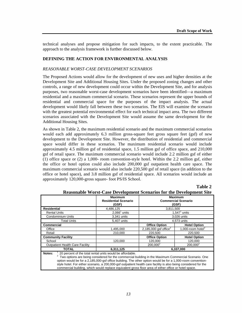
The Proposed Actions would allow for the development of new uses and higher densities at the Development Site and Additional Housing Sites. Under the proposed zoning changes and other controls, a range of new development could occur within the Development Site, and for analysis purposes, two reasonable worst-case development scenarios have been identified—a maximum residential and a maximum commercial scenario. These scenarios represent the upper bounds of residential and commercial space for the purposes of the impact analysis. The actual development would likely fall between these two scenarios. The EIS will examine the scenario with the greatest potential environmental effect for each technical impact area. The two different scenarios associated with the Development Site would assume the same development for the Additional Housing Sites.
As shown in Table 2, the maximum residential scenario and the maximum commercial scenarios would each add approximately 6.3 million gross-square feet gross square feet (gsf) of new development to the Development Site. However, the distribution of residential and commercial space would differ in these scenarios. The maximum residential scenario would include approximately 4.5 million gsf of residential space, 1.5 million gsf of office space, and 210,000 gsf of retail space. The maximum commercial scenario would include 2.2 million gsf of either (1) office space or (2) a 1,000- room convention-style hotel. Within the 2.2 million gsf, either the office or hotel option could also include 200,000 gsf outpatient health care space. The maximum commercial scenario would also include 220,500 gsf of retail space (in addition to the office or hotel space), and 3.8 million gsf of residential space. All scenarios would include an approximately 120,000-gross square- foot PS/IS School.
Table 2Reasonable Worst-Case Development Scenarios for the Development Site
Maximum Residential Scenario
(GSF)
Maximum Commercial Scenario
(GSF) Residential 4,486,125 3,811,500
Rental Units 2,0661 units 1,5471 units Condominium Units 3,341 units 3,026 units
Total Units 5,407 units 4,573 units Commercial Office Option Hotel Option
Office 1,495,000 2,185,000 gsf office2 1,000-room hotel2 Retail 210,000 220,500 220,500
Community Facility Office Option Hotel Option School 120,000 120,000 120,000 Outpatient Health Care Facility 200,0002 200,0002
TOTAL 6,311,125 6,337,000 Notes: 1 20 percent of the total rental units would be affordable.
2 Two options are being considered for the commercial building in the Maximum Commercial Scenario. One option would be for a 2,185,000-gsf office building. The other option would be for a 1,000-room convention-style hotel. For either scenario, a 200,000-gsf outpatient health care facility is also being considered for the commercial building, which would replace equivalent gross floor area of either office or hotel space.
Western Rail Yard
The Proposed Actions would include the development of residential and local retail at the Additional Housing Sites. For the Additional Housing Sites, the EIS will analyze the maximum development that could be accommodated by the proposed zoning and other land use actions.
ANALYSIS YEARS
OPERATION ANALYSIS
As previously described, construction at the Development Site would take place over a 8-year period, starting with platform construction in 2010 and finishing with the construction and occupancy of the residential buildings in 2018. Construction at the Additional Housing Sites is expected to be completed by 2016 for the Ninth Avenue site and by 2018 for the Tenth Avenue site.
The analysis of the Proposed Actions will be performed for the expected year of completion of the project, which is 2018. An assessment of the Proposed Actions’ potential environmental impacts will also be undertaken for a 2016 interim year of development, after the first four buildings (out of a total of nine) are projected to be constructed and occupied (see Table 1). That assessment will be undertaken for the purposes of determining: (i) whether any significant adverse impacts identified with the completion of the Proposed Actions would occur in 2016; (ii) the availability and feasibility of mitigation measures for significant adverse impacts projected to occur in 2016 and (iii) the potential for any significant adverse impacts to occur in 2016 that would be eliminated by the completion of the full development program for the Proposed Actions. In addition, an examination will be undertaken to determine whether any significant adverse environmental impacts identified in 2016 would occur in an earlier year. The availability and feasibility of mitigation measures at that time would also be considered.
For each analysis year, the Future without the Proposed Actions condition will provide a baseline condition that will be evaluated and compared to the incremental changes due to the Proposed Actions. The Future without the Proposed Actions condition will use existing conditions as a baseline and add to it projects that are currently in construction, expected, or proposed to be in place by the analysis year.
CONSTRUCTION ANALYSIS
The construction analyses will address conditions during peak construction at the project sites. As appropriate, some of the construction analyses, such as air quality, will also address a second scenario that would analyze the effects of project related construction during the period of the highest cumulative construction activities for the Development Site and for other nearby construction projects. This would be based primarily on the largest air quality emission generation potential at nearby construction areas of the No. 7 Subway station at Eleventh Avenue and West 34th Street, the Eastern Rail Yard development, the ARC project, and individual development sites in the Hudson Yards area.
SCOPE OF WORK As described earlier, the EIS for the Proposed Actions will be prepared pursuant to SEQRA and CEQR. The environmental review provides a means for decision-makers to systematically consider environmental effects along with other aspects of project planning and design, to
14
Draft Scope of Work
evaluate reasonable alternatives, and to identify, and mitigate where practicable, any significant adverse environmental impacts.
The EIS will contain:
A. A description of the Proposed Actions and the environmental setting;
B. A statement of the environmental impacts of the Proposed Actions, including its short- and long-term effects and typical associated environmental effects;
C. An identification of any adverse environmental effects that cannot be avoided if the project is implemented;
D. A discussion of reasonable alternatives to the Proposed Actions;
E. An identification of irreversible and irretrievable commitments of resources that would be involved if the Proposed Actions are built; and
F. A description of measures proposed to minimize or fully mitigate any significant adverse environmental impacts.
The first step in preparing the EIS document is the public scoping process. Scoping is the process of focusing the environmental impact analysis on the key issues that are to be studied in the EIS. The proposed scope of work for each technical area to be analyzed in the Western Rail Yard EIS follows. The scope of work and the proposed impact assessment criteria below are based on the methodologies and guidance set forth in the CEQR Technical Manual.
TASK 1. PROJECT DESCRIPTION
The first chapter of the EIS will introduce the reader to the Proposed Actions and set the context in which to assess impacts. This chapter will provide a detailed description of the project, including project location and boundaries, existing uses on the sites, and proposed uses. Building on and refining the information provided above, the chapter will also include a statement of the purpose and need for the Proposed Actions, including relevant public policy goals and objectives relating to the development of the Proposed Actions. The project description will also discuss the planning history of the sites. This chapter is the key to understanding the Proposed Actions and their impact, and gives the public and decision-makers a base from which to evaluate the Proposed Actions. The chapter will also provide detailed descriptions of the required actions and approvals necessary for project implementation, the roles of the involved public agencies, and the ULURP and SEQRA/CEQR processes.
TASK 2. FRAMEWORK FOR ANALYSIS
This chapter will discuss the framework for the analyses for the EIS. It will identify the analysis years and project phasing, and describe the development scenarios that will be assessed in the EIS. Each impact category will discuss the existing conditions, Future without the Proposed Actions condition, and Future with the Proposed Actions condition. The technical analysis and identification of potential significant adverse impacts will be focused on the incremental change to the environmental setting that the Proposed Actions would create as compared to the Future without the Proposed Actions condition. Consequently, this chapter will also comprehensively define the environmental setting expected in the future without the project, establishing the conditions in the Future without the Proposed Actions baseline growth that will be analyzed in all the technical areas.
15
Western Rail Yard
As described earlier, the reasonable worst-case residential and commercial development scenarios for the Development Site may vary between different tasks in order to quantitatively analyze the scenario that would result in the greatest potential impacts for each impact category. In addition, the analysis of potential impacts as a result of developing the two Additional Housing Sites will be assessed in the technical areas below.
The EIS will include a generic analysis of the potential environmental impacts that could result from relocating New York City Department of Sanitation from the Development Site, and any other permanently displaced uses. At present, sites have not been identified for the relocation of these uses.
TASK 3. LAND USE, ZONING, AND PUBLIC POLICY
The land use, zoning, and public policy analysis will assess the potential impacts of the expected changes in land uses resulting from the Proposed Actions. The analysis will also consider the Proposed Action’s consistency with, and effect on, the area’s zoning and other applicable public policies, as well as evaluate impacts within the project sites and within defined land use study areas.
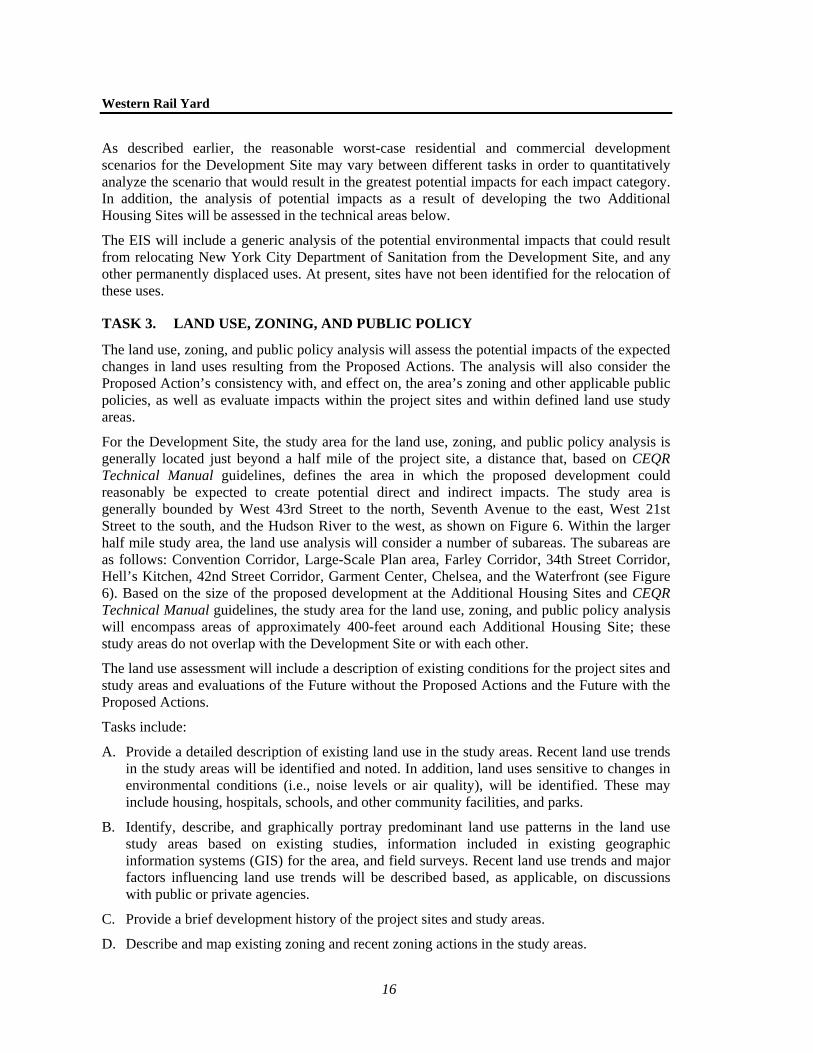
For the Development Site, the study area for the land use, zoning, and public policy analysis is generally located just beyond a half mile of the project site, a distance that, based on CEQR Technical Manual guidelines, defines the area in which the proposed development could reasonably be expected to create potential direct and indirect impacts. The study area is generally bounded by West 43rd Street to the north, Seventh Avenue to the east, West 21st Street to the south, and the Hudson River to the west, as shown on Figure 6. Within the larger half mile study area, the land use analysis will consider a number of subareas. The subareas are as follows: Convention Corridor, Large-Scale Plan area, Farley Corridor, 34th Street Corridor, Hell’s Kitchen, 42nd Street Corridor, Garment Center, Chelsea, and the Waterfront (see Figure 6). Based on the size of the proposed development at the Additional Housing Sites and CEQR Technical Manual guidelines, the study area for the land use, zoning, and public policy analysis will encompass areas of approximately 400-feet around each Additional Housing Site; these study areas do not overlap with the Development Site or with each other.
The land use assessment will include a description of existing conditions for the project sites and study areas and evaluations of the Future without the Proposed Actions and the Future with the Proposed Actions.
Tasks include:
A. Provide a detailed description of existing land use in the study areas. Recent land use trends in the study areas will be identified and noted. In addition, land uses sensitive to changes in environmental conditions (i.e., noise levels or air quality), will be identified. These may include housing, hospitals, schools, and other community facilities, and parks.
B. Identify, describe, and graphically portray predominant land use patterns in the land use study areas based on existing studies, information included in existing geographic information systems (GIS) for the area, and field surveys. Recent land use trends and major factors influencing land use trends will be described based, as applicable, on discussions with public or private agencies.
C. Provide a brief development history of the project sites and study areas.
D. Describe and map existing zoning and recent zoning actions in the study areas.
16
HU
DS
ON
RIV
ER
DE WITTCLINTON
PARK
W. 56TH ST.
W. 55TH ST.
W. 54TH ST.
NIN
TH A
VE.
TEN
TH A
VE.
ELEV
ENTH
AVE
.
W. 53RD ST.
W. 52ND ST.
W. 51ST ST.
W. 50TH ST.
W. 49TH ST.
W. 48TH ST.
W. 47TH ST.
W. 46TH ST.
W. 45TH ST.
W. 44TH ST.
W. 43RD ST.
W. 42ND ST.
EIG
HTH
AVE
.
SEVE
NTH
AVE
.
BRO
ADW
AY
W. 41ST ST.
W. 40TH ST.
W. 39TH ST.
W. 38TH ST.
W. 36TH ST.
W. 37TH ST.
W. 35TH ST.
W. 34TH ST.
W. 33RD ST.
W. 32ND ST.
W. 31ST ST.
W. 30TH ST.
W. 29TH ST.
W. 28TH ST.
W. 27TH ST.
W. 26TH ST.
W. 25TH ST.
W. 24TH ST.
W. 23RD ST.
NIN
TH A
VE.
TEN
TH A
VE.
RO
UTE
9A
RO
UTE
9A
ELEV
ENTH
AVE
.
EIG
HTH
AVE
.
SEVE
NTH
AVE
.
SIXT
H A
VE.
E. 23RD ST.FI
FTH
AVE
.
BROADW
AY
E. 42ND ST.
E. 34TH ST.
FIFT
H A
VE.
MAD
ISO
N A
VE.
PAR
K AV
E.PA
RK
AVE.
PAR
K AV
E SO
.
VAN
DER
BILT
AVE
.
MAD
ISO
N A
VE.
SIXT
H A
VE.
W. 22ND ST.
W. 21ST ST.
W. 20TH ST.
W. 19TH ST.
76
66
64
62
61
81
83
84
86
88
90
76
72
66
64
62
61
82
78
79
83
84
86
88
90
92
CONVENTIONCENTER
WESTERN RAILYARD
EASTERN RAILYARD
USPS
DSNY
USPS
USPS
STARRETTLEHIGH
QUILLBUS DEPOT
PORTAUTHORITY
BUS TERMINAL
MADISONSQUAREGARDEN/
PENNSTA
TWOPENNPLAZA
GRANDCENTRALTERMINAL
ONE PENN PLAZA
CONEDISON
A B
C
D
E
F
G
H
I
8.25
.08
SCALE
0 1000 FEET
N
FARLEYBLDG
WESTERN RAIL YARDLand Use Study Area
Figure 6
Project Sites
1/2-Mile Perimeter
Development Site Study Area Boundary
Development Site Study Area:Subarea Boundary
Additional Housing Sites:400-Foot Study Area
Convention Corridor
Large Scale Plan
Farley Corridor
34th Street Corridor
Hells Kitchen
42nd Street Corridor
Garment Center
Chelsea
Waterfront
Development Site Study Area: Subarea Boundaries
A
B
C
D
E
F
G
H
I
Draft Scope of Work
E. Describe relevant public policies that apply to the project sites and study areas, such as the New York City Comprehensive Waterfront Revitalization Plan, zoning, PlaNYC, and other identified public policies.
F. List future development projects in the study areas that could affect future land use patterns and trends by 2016 and 2018. Identify specific development projects, plans for public improvements, and pending zoning actions or other public policy actions as they relate to the Proposed Actions. Based on these changes, assess future land use and zoning conditions in the Future without the Proposed Actions.
G. Identify potential impacts of the Proposed Actions on land use and land use trends, zoning, and public policy, and assess the compatibility of the Proposed Actions with surrounding land uses and the consistency of the Proposed Actions with recognized public policies, such as zoning and other identified public policies.
H. Consider the potential for the proposed zoning text amendment associated with the Tenth Avenue Additional Housing Site, to affect other applicable sites.
TASK 4. SOCIOECONOMIC CONDITIONS
Socioeconomic impacts can occur when a proposed action directly or indirectly changes economic activities in an area. The purpose of a socioeconomic assessment is to disclose changes that would be created by a proposed action and identify whether they rise to a significant level. This chapter will examine the effects of the Proposed Actions on socioeconomic conditions in the study areas, which will generally conform to the land use study areas outlined in Task 3.
According to the CEQR Technical Manual, the five principal issues of concern with respect to socioeconomic conditions are whether a proposed action would result in significant impacts due to: (1) direct residential displacement; (2) direct business and institutional displacement; (3) indirect residential displacement; (4) indirect business and institutional displacement; and (5) adverse effects on a specific industry.
In conformance with the CEQR Technical Manual guidelines, the assessment of these five areas of concern will begin with a preliminary assessment. Detailed analyses will be conducted for those areas in which the preliminary assessment cannot definitively rule out the potential for significant adverse impacts. The detailed assessments will be framed in the context of existing conditions and evaluations of the conditions in the Future with and without the Proposed Actions.
DIRECT RESIDENTIAL DISPLACEMENT
Because the project sites do not contain any dwelling units, the Proposed Actions would not result in significant adverse impacts due to direct residential displacement, and no further analysis of this issue is required.
DIRECT BUSINESS AND INSTITUTIONAL DISPLACEMENT
The Tenth Avenue Additional Housing Site does not contain any businesses or institutions. Development at the Ninth Avenue Additional Housing Site would occur at a surface parking lot currently used by the MTA/NYCT. As discussed above, the Development Site is currently being used as a rail storage yard that is operated by LIRR. The south edge of the site on West 30th
17
Western Rail Yard
Street also includes facilities rented on a month to month basis by a private bus company and the New York City Department of Sanitation. These uses would be directly displaced by the Proposed Actions.
With the Proposed Actions, development would occur on a platform built over the rail yard and there is no expected permanent displacement of train yard activities (as noted in the project description above, there would be temporary or periodic track outages during construction). The displacement of the existing uses will be disclosed and qualitatively assessed.
INDIRECT RESIDENTIAL DISPLACEMENT
According to the CEQR Technical Manual, because the Proposed Actions would introduce more than 200 residential units, a preliminary assessment of indirect residential impacts is required under CEQR.
The indirect residential displacement analysis will use 1990 and 2000 U.S. Census data, 2008 estimates from the New York City Department of Finance’s Real Property Assessment Data (RPAD) database and ESRI Business Analyst, as well as current real estate market data, to present demographic and residential market trends and conditions for the study area. Following the methodologies outlined in the CEQR Technical Manual, the analysis of indirect residential displacement will:
A. Determine if the Proposed Actions would add a substantial new population with different socioeconomic characteristics compared to the size and character of the existing population;
B. Determine if the Proposed Actions would directly displace uses or properties that have had a “blighting” effect on property values in the area;
C. Determine if the Proposed Actions would directly displace enough of one or more components of the population to alter the socioeconomic composition of the study area;
D. Determine if the Proposed Actions would introduce a substantial amount of a more costly type of housing compared to existing housing and housing expected to be built in the study area by the time the project is complete;
E. Determine if the Proposed Actions would introduce a “critical mass” of non-residential uses such that the surrounding area becomes more attractive as a residential neighborhood complex; and
F. Determine if the Proposed Actions would introduce a land use that could offset positive trends in the study area, impede efforts to attract investment to the area, or create a climate for disinvestment.
If a preliminary assessment does not rule out the possibility that the Proposed Actions could cause significant adverse impacts due to indirect residential displacement, a more detailed analysis will be conducted. The approach to the detailed assessment of indirect residential displacement is similar to that of the preliminary assessment, but requires more in-depth analysis to identify populations that may be vulnerable to displacement. The detailed analysis would characterize existing conditions in the study area, assess current and future socioeconomic trends in the area that may affect these populations, examine the effects of the Proposed Actions on prevailing socioeconomic trends, and thus determine its impact on the identified populations at risk.
18
Draft Scope of Work
INDIRECT BUSINESS AND INSTITUTIONAL DISPLACEMENT
According to the CEQR Technical Manual, because the Proposed Actions are anticipated to introduce more than 200,000 square feet of commercial use, a preliminary assessment of indirect business and institutional impacts is required under CEQR. The objective of the indirect business and institutional displacement analysis will be to determine if the Proposed Actions would ultimately lead to higher rents or property values in commercial and industrial buildings in the primary and secondary study areas, causing existing businesses to relocate from the study areas, or from the City as a whole.
The indirect business and institutional displacement analysis will identify and characterize conditions and trends in employment and business within the study area using data from the following sources: U.S. Census; New York State Department of Labor; ESRI, Inc.; Dunn & Bradstreet; rental rate and sales price data from local brokerage firms; and zoning and land use information gathered as part of the broader EIS effort. Following the methodologies outlined in the CEQR Technical Manual, the analysis of indirect business and institutional displacement will:
G. Determine if the Proposed Actions would introduce a new type of economic activity that would change existing economic patterns;
H. Determine if the Proposed Actions would add to the concentration of a particular sector of the local economy enough to alter or accelerate an ongoing trend to alter existing economic patterns;
I. Determine if the Proposed Actions would directly displace uses that have had a “blighting” effect on commercial property values in the area, leading to rises in commercial rents;
J. Determine if the Proposed Actions would directly displace uses of any type that directly support businesses in the area or bring people to the area that form a customer base for local businesses;
K. Determine if the Proposed Actions would directly or indirectly displace residents, workers, or visitors who form the customer base for existing businesses in the study area; and
L. Determine if the Proposed Actions would introduce a land use that would offset positive trends in the study area, impede efforts to attract investment to the area, or create a climate for disinvestment in the area.
If a preliminary assessment does not rule out the possibility that the Proposed Actions could cause significant adverse impacts due to indirect business and institutional displacement, a more detailed analysis will be conducted. The approach to the detailed assessment of indirect business and institutional displacement is similar to that of the preliminary assessment, but requires more in-depth analysis in order to determine whether the study area includes any potentially vulnerable categories of businesses or institutions. The detailed assessment of indirect business and institutional displacement would characterize the existing economic profile of the study area and will assess current and future trends that may affect the underlying economic base of the target area. It will also examine the effects of the Proposed Actions on property values or rents, and determine if this would make existing categories of tenants vulnerable to displacement.
19
Western Rail Yard
ADVERSE EFFECTS ON A SPECIFIC INDUSTRY
Based on the guidelines in the CEQR Technical Manual, the analysis for effects on specific industries will:
M. Determine if the Proposed Actions would significantly affect business conditions in any industry or category of businesses within or outside the study area; and
N. Determine if the Proposed Actions would substantially reduce employment or impair the economic viability in a specific industry or category of businesses.
The analysis will draw on the economic and real estate data compiled in assessing direct and indirect displacement impacts, as well as other published data, data from impact analyses contained in other chapters of the EIS and field surveys, as appropriate.
TASK 5. COMMUNITY FACILITIES AND SERVICES
The demand for community facilities and services is directly related to the type and size of the new population generated by development resulting from the Proposed Actions. This chapter of the EIS will evaluate the effects on community services due to the Proposed Actions, including effects on police and fire protection, public schools, outpatient and emergency health care facilities, libraries, and publicly funded day care facilities. The community facilities and services assessment will include a description of existing conditions and evaluations of the conditions in the Future with and without the Proposed Actions.
According to the CEQR Technical Manual, preliminary thresholds indicating the need for detailed analyses are as follows:
Public Schools: More than 50 new elementary/middle school or 150 new high school students.
Libraries: A greater than five percent increase in ratio of residential units to libraries in the borough. For Manhattan, this is equivalent to a residential population increase of 901 residential units.
Health Care Facilities (outpatient): More than 600 low- to moderate-income residential units.
Day Care Centers (publicly funded): More than 50 eligible children based on the number of new low/moderate-income residential units by borough. For Manhattan, this is equivalent to an increase of 357 low-income or 417 low/moderate-income residential units.
Fire Protection: The ability of the fire department to provide fire protective services for a new project usually does not warrant a detailed assessment under CEQR. Generally, a detailed assessment of fire protective services is included only if a proposed action would affect either the physical operations of, or access to and from, a station house.
Police Protection: The ability of the police department to provide public safety for a new project usually does not warrant a detailed assessment under CEQR. Generally an assessment of police protective services is included only if a proposed action would affect either the physical operations of, or access to and from, a precinct house.
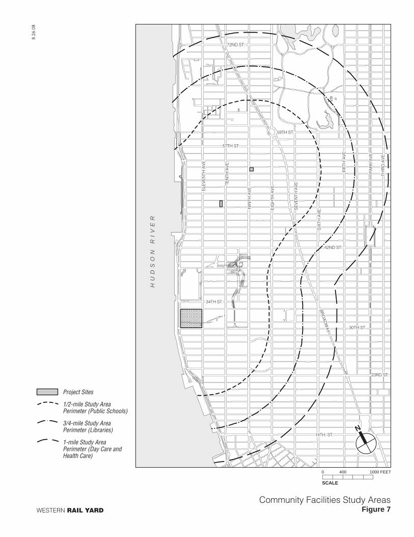
Based on these thresholds and the assumptions of the Proposed Actions, detailed analyses will be conducted, as applicable, for public schools, libraries, health care facilities and day care facilities. The proposed study area for community facilities would be located at or close to a half mile, quarter mile or one-mile radius of the project sites depending on the type of community facility, as per CEQR guidelines (refer to Figure 7). Subtasks will include:
20
FIFT
H A
VE
.
EIG
HTH
AV
E.
SE
VE
NTH
AV
E.
SIX
TH A
VE
.
BR
OA
DW
AY
59TH ST.
72ND ST.
57TH ST.
42ND ST.
34TH ST.
30TH ST.
TEN
TH A
VE
.
NIN
TH A
VE
.
ELE
VE
NTH
AV
E.
23RD ST.
14TH. ST.
HU
DS
ON
R
IV
ER
PA
RK
AV
E.
THIR
D A
VE
.
8.26
.08
WESTERN RAIL YARD
Community Facilities Study AreasFigure 7
N
SCALE
0 400 1000 FEET
Project Sites
1/2-mile Study Area Perimeter (Public Schools)
3/4-mile Study Area Perimeter (Libraries)
1-mile Study Area Perimeter (Day Care and Health Care)

Draft Scope of Work
A. Identify and locate/map all community facilities within the defined study area for general informational purposes, including schools, libraries, health care facilities, police precincts, fire houses, etc. Separate maps for each type of facility will be provided.
B. Identify and locate public schools within the study area. Assess conditions in the study area, and for each affected school district as a whole, in terms of enrollment and utilization during the current school year, noting any specific shortages of school capacity. Identify conditions that will exist in the Future without the Proposed Actions, taking into consideration projected increases in future enrollment, including those associated with other developments in the vicinity of the project sites and plans to increase school capacity either through administrative actions on the part of the New York City Department of Education (DOE) or as a result of the construction of new school space. Analyze future Build conditions, adding students likely to be generated by the Proposed Actions to the projections for the Future without the Proposed Actions. Project impacts will be assessed based on the difference between the Build projections and the No Build projections (at the study area and school district levels) for enrollment, capacity, and utilization. Planned new capacity projects from DOE’s Five Year Capital Plan will not be included in the quantitative analysis unless the projects have commenced site preparation and/or construction. The new projects may, however, be included in a qualitative discussion after impacts, if any, have been identified. Sources for the information will be noted in the EIS.
C. Identify the local public library branch(es) serving the area. Describe existing population served by the branch(es), using information gathered for socioeconomic conditions assessment and information services provided by branch(es). Circulation, level of utilization, and other relevant existing conditions will be based on publicly available information and/or consultation with the New York Public Library (NYPL) administration. Sources for the information will be noted in the EIS. For No Build conditions, projections of population change in the area and information on any planned changes in library services of facilities will be described and the effects of these changes on conditions will be assessed qualitatively. The effects of the addition of the population resulting from the projected developments will be qualitatively assessed in terms of special programs, facilities, and collections, with input from library branch management staff.
D. Identify hospital emergency room services and outpatient ambulatory care facilities (regulated by the New York State Department of Health and Office of Mental Health) within approximately one mile of the project sites. Describe each facility in terms of its address, the type of service provided, an indicator of its size, capacity or utilization, and any other relevant existing conditions based on publicly available information and/or consultation with health care officials. For No Build conditions, the projected change in the area’s low-moderate-income population and any planned changes in health care facilities or services will be described, and the effects of these changes on the operating capacity of the facilities will be assessed. The potential effects on health care facilities from the additional population resulting from the Proposed Actions will be assessed in comparison with the effects of changes expected to occur in the Future without the Proposed Actions. Sources for the information will be noted in the EIS.
E. Identify existing public day care and head start facilities within approximately one mile of the project sites. Describe each facility in terms of its location, ages served, number of slots (capacity), existing enrollment and length of waiting list. Information will be based on publicly available information and/or consultation with the Administration for Children’s
21
Western Rail Yard
Services’ Division of Child Care and Headstart (CCHS). Sources for the information will be noted in the EIS. For No Build conditions, information will be obtained on any changes planned for day care programs or facilities in the area, including closing or expansion of existing facilities and establishment of new facilities. Any expected increases in the population of children under 12 within the eligibility income limitations, based on CEQR methodology (Table 3C-4), will be discussed as potential additional demand; and the potential effect of any population increases on demand for day care services in the study area will be assessed. The potential effects of the additional eligible children resulting from the Proposed Actions will be assessed by comparing the estimated net demand over capacity to the net demand over capacity estimated in the future No Build analysis.
The Proposed Actions would not directly affect operations or access to and from police and fire facilities and therefore would not warrant a detailed assessment in accordance with the guidelines in the CEQR Technical Manual. However, since the Proposed Actions would include more than six million gross square feet of mixed uses, the EIS will assess potential impacts on police and fire services. For these analyses, an inventory of existing police precincts and fire stations (including emergency medical services) will be developed. Information about the Proposed Actions will be provided to the police and fire departments and they will address the potential for the Proposed Actions to affect their services.
TASK 6. OPEN SPACE
The Proposed Actions would create approximately 5 acres of publicly accessible open space on the Development Site. As described earlier, it would also provide a connection to the High Line Park to the south. The CEQR Technical Manual recommends a detailed assessment of a project’s effects on open space if a project is expected to generate more than 500 employees or 200 residents, or a similar substantial number of other users. Development associated with the Proposed Actions would exceed both of these thresholds and would have an effect on the utilization of open space and recreational uses in the surrounding area, and on the new publicly accessible open space that would be developed as a result of the Proposed Actions. Therefore, a detailed open space analysis will be conducted.
This section of the EIS will assess potential direct and/or indirect impacts of the Proposed Actions on open space. A discussion of the open space added by the Proposed Actions will be provided. Tasks for the open space analysis will include:
A. Establish study area boundaries, specifically: a study area of a quarter mile for the worker population, and a study area of a half mile for the residential population. All Census tracts with at least 50 percent of their area falling within these study areas will be included in the open space study areas (see Figure 8).
B. Prepare a demographic analysis of the residential and worker populations of the study areas. Determine the population in the open space study areas based on the 2000 Census of Population and Housing. Estimate employment in the open space study areas using reverse journey-to-work data. Use 2000 Census data to identify the age breakdown of the study area population.
C. Compile an inventory of all publicly-accessible active and passive open spaces, both publicly and privately owned, for the study areas. This will be accomplished through coordination with DPR and private owners of open spaces, and verified through field visits. The inventory will include an evaluation of the condition and use of existing open spaces, as
22
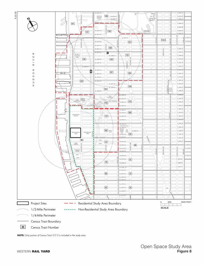
ZOO
E. 24TH ST.
E. 23RD ST.
E. 22ND ST.
UNIONSQUARE
W. 23RD ST.
W. 22ND ST.
W. 21ST ST.
W. 20TH ST.
W. 19TH ST.
W. 18TH ST.
W. 17TH ST.
W. 16TH ST.
W. 15TH ST.
W. 14TH ST.
GANSEVOORT ST.
SIXTH AVE.
W. 32ND ST.
W. 28TH ST.
W. 27TH ST.
W. 26TH ST.
NIN
TH A
VE.
TEN
TH A
VE.
ELEV
ENTH
AVE
.
EIG
HTH
AVE
.
SEVE
NTH
AVE
.
SIXT
H A
VE.
BROADW
AY
W. 42ND ST.
W. 41ST ST.
W. 40TH ST.
W. 39TH ST.
W. 38TH ST.
W. 36TH ST.
W. 37TH ST.
W. 35TH ST.
W. 34TH ST.
W. 33RD ST.
W. 31ST ST.
W. 30TH ST.
W. 29TH ST.
W. 25TH ST.
W. 24TH ST.
W. 23RD ST.
E. 26TH ST.
E. 25TH ST.FI
FTH
AVE
.
E. 31ST ST.
E. 30TH ST.
E. 29TH ST.
E. 28TH ST.
E. 27TH ST.
MAD
ISO
N A
VE.
LEXI
NG
TON
AVE
.
THIR
D A
VE.
PAR
K AV
E.
E. 54TH ST.
E. 53RD ST.
E. 52ND ST.
E. 51ST ST.
E. 50TH ST.
E. 49TH ST.
E. 48TH ST.
E. 47TH ST.
E. 46TH ST.
E. 45TH ST.
E. 44TH ST.
E. 43RD ST.
E. 42ND ST.
E. 41ST ST.
E. 40TH ST.
E. 39TH ST.
E. 38TH ST.
E. 37TH ST.
E. 36TH ST.
E. 35TH ST.
E. 34TH ST.
E. 33RD ST.
E. 32ND ST.
NIN
TH A
VE.
EIG
HTH
AVE
.
SEVE
NTH
AVE
.
BRO
ADW
AY
SIXT
H A
VE.
E. 57TH ST.
E. 56TH ST.
E. 55TH ST.
FIFT
H A
VE.
MAD
ISO
N A
VE.
PAR
K AV
E.
LEXI
NG
TON
AVE
.
THIR
D A
VE.
E. 61ST ST.
E. 60TH ST.
E. 59TH ST.
E. 58TH ST.
E. 64TH ST.
E. 63RD ST.
E. 62ND ST.
E. 65TH ST.
AMST
ERD
AM A
VE.
W. 64TH ST.
W. 63RD ST.
W. 65TH ST.
LINCOLNCENTERPLAZA
CO
LUM
BUS
AVE.
W. 62ND ST.
W. 60TH ST.
W. 59TH ST.
W. 58TH ST.
W. 57TH ST.
W. 56TH ST.
W. 55TH ST.
W. 54TH ST.
W. 53RD ST.
W. 52ND ST.
W. 51ST ST.
W. 50TH ST.
W. 49TH ST.
W. 48TH ST.
W. 47TH ST.
W. 46TH ST.
W. 45TH ST.
W. 44TH ST.
W. 43RD ST.TE
NTH
AVE
.
WES
T EN
D A
VE.
CENTRAL PARK SOUTH
CEN
TRAL
PAR
K W
EST
THE POND
DE WITTCLINTON
PARK
ELEV
ENTH
AVE
.
VAN
DER
BILT
AVE
.
CONVENTIONCENTER
WESTERN RAILYARD
EASTERN RAILYARD
USPS
DSNY
USPS
USPS
STARRETTLEHIGH
QUILLBUS DEPOT
PORTAUTHORITY
BUS TERMINAL
MADISONSQUAREGARDEN/
PENNSTA
TWOPENNPLAZA
GRANDCENTRALTERMINAL
ONE PENN PLAZA
CONEDISON
FARLEYBLDG
HU
DS
ON
R
IV
ER
99
111
103
101
95
113
119
121
127 125
131
112.2
317.2
137
133
139
145
149
115
117
129
135
151
147
9391
89
109
97
87
83 81
8.20
.08
N
WESTERN RAIL YARDOpen Space Study Area
Figure 8
SCALE
0 600 1500 FEETProject Sites
1/2-Mile Perimeter
1/4-Mile Perimeter
Census Tract Boundary
Census Tract Number
Residential Study Area Boundary
Non-Residential Study Area Boundary
NOTE: Only portion of Census Tract 317.2 is included in the study area
89
Draft Scope of Work
well as acreage. Qualitative discussions of major publicly-accessible open spaces in proximity to the project sites but outside the half mile study area will also be included.
D. In conformance with CEQR Technical Manual methodologies, assess the adequacy of existing publicly-accessible open space facilities. This analysis will include a quantitative assessment of the ratio of open space to population and a qualitative assessment that considers such factors as the proximity of other open spaces outside the study area.
E. For the Future without the Proposed Actions condition, assess expected changes in future levels of open space supply and demand based on other planned development projects within the study areas and any public open space expected to be developed. Open space ratios for both residential and worker populations will be developed for future conditions and compared with existing ratios to determine changes in future levels of adequacy.
F. Based on the residential and worker populations to be added by the Proposed Actions, as well as the new publicly-accessible open spaces to be provided, assess the Proposed Actions’ indirect effects on the open space with regards to supply and demand in the study areas. This will include a quantitative assessment of project impacts based on a comparison of open space ratios in the Future with and without the Proposed Actions. It will also include a qualitative evaluation that considers such factors as the proximity of other open spaces outside the study areas.
G. In coordination with other tasks, identify any potential direct impacts on open spaces from shadows, air quality, or noise generated by the Proposed Actions.
TASK 7. SHADOWS
The CEQR Technical Manual requires a shadow analysis for proposed projects that have the potential for new shadows long enough to reach an existing publicly accessible open space, important natural feature, or historic resource with sun-sensitive features. The Proposed Actions would result in the creation of several new buildings that could cast new shadows on existing and future nearby sun-sensitive resources. This chapter will examine the extent of incremental shadows (additional shadows beyond the existing shadows) that would be caused by the Proposed Actions on any sun-sensitive uses. The chapter will also include a discussion of how the proposed open space added by the Proposed Project could be affected by shadow. However, any such shadowing is not considered for impact purposes, as the open spaces would be created as part of the Proposed Project. Tasks for the shadows analysis will include:
A. Identify publicly accessible open space, important natural features such as the Hudson River within the study area, and historic resources with sun-sensitive features within the path of shadows that would be cast by the Proposed Actions. In coordination with the analyses for open space and historic resources, map and describe any sun-sensitive areas. For open spaces, map active and passive recreation areas and features of the open spaces, such as benches or play equipment.
B. Prepare shadow diagrams for time periods when incremental shadows from the new buildings could fall onto publicly accessible open spaces, important natural features, and any historic resource with sun-sensitive features. These diagrams will be prepared for up to four representative analysis days if shadows from the proposed buildings would fall onto any sun-sensitive resources on that day. The four analysis days are:
23
Western Rail Yard
March 21—the vernal equinox, which is the equivalent of September 21, the autumnal equinox;
May 6—the midpoint between the vernal equinox and the longest day of the year, which is the equivalent to August 6—the midpoint between the equinox and the shortest day of the year;
June 21—the longest day of the year; and
December 21—the shortest day of the year.
C. Describe the effect of the incremental shadows on the publicly accessible open spaces, important natural features, as well as any historic resources with sun-sensitive features based on the shadow diagrams for each of the analysis dates. Assess the effects of the Proposed Actions’ incremental shadows.
D. If open space, important natural features, or any historic resource with sun-sensitive features would be affected by a project-generated incremental shadow for a significant amount of time, the duration of the Proposed Actions’ increment will be compared with the amount of sunlight on those areas under conditions in the Future without the Proposed Actions in place (No Build).
TASK 8. HISTORIC RESOURCES
The CEQR Technical Manual identifies historic resources as districts, buildings, structures, sites, and objects of historical, aesthetic, cultural, and archaeological importance. This includes designated NYC Landmarks and Historic Districts; properties calendared for consideration as landmarks by the New York City Landmarks Preservation Commission (LPC); properties listed on, or formally determined eligible for listing on, the State/National Registers of Historic Places State and National Registers of Historic Places (S/NR) or contained within a district listed on or determined eligible for S/NR listing; properties recommended by the New York State Board for listing on the S/NR; National Historic Landmarks; and properties not identified by one of the programs listed above, but that meet their eligibility requirements. There is one historic resource located on the project sites—the High Line rail viaduct, which is located partly on the Development Site, and has been determined eligible for S/NR listing.
None of the lots on the Development Site were determined to be sensitive for archaeological resources in the 2004 No. 7 Subway Extension – Hudson Yards Rezoning and Development Program Final Generic Environmental Impact Statement (FGEIS). In addition, LPC was contacted for their preliminary determination of the Additional Housing Sites’ potential archaeological sensitivity, and in an Environmental Review letter dated June 26, 2008, LPC determined that the two Additional Housing Sites have no archaeological significance. Therefore, no further consideration of archaeological resources is warranted and the assessment will focus on historic architectural resources.
Potential impacts on architectural resources will be considered within an 800-foot radius surrounding the Development Site and within a 400-foot radius surrounding each of the Additional Housing Sites to account for both direct and indirect impacts. For the Development Site, the standard CEQR-recommended study area of 400 feet will be expanded to 800 feet to account for the site’s large footprint and the tall height of the buildings proposed for the site. These study areas will be expanded as necessary in conjunction with the shadows analysis (described above) if the proposed buildings have the potential to cast shadows on historic
24
Draft Scope of Work
resources with sun-sensitive features outside of the study areas. Tasks within this chapter are as follows:
A. Map and briefly describe known architectural resources on the project sites and within the study areas. These comprise the property types listed above.
B. Identify any potential architectural resources in the study areas that could be affected by the Proposed Actions. Potential architectural resources comprise properties that may meet the eligibility criteria for S/NR listing and/or New York City Landmark (NYCL) designation. The identification of potential architectural resources will be based on criteria for listing on the National Register as found in the Code of Federal Regulations, Title 36, Part 60 and will be undertaken in consultation with LPC and the New York State Office of Parks, Recreation and Historic Preservation (OPRHP). Determinations of eligibility by OPRHP and LPC will be sought for any potential resources in the study areas. Map and describe any identified potential architectural resources.
C. Based on planned development projects, qualitatively discuss any impacts on architectural resources that are expected in the Future without the Proposed Actions.
D. Assess any direct physical impacts of the Proposed Actions on architectural resources. In conjunction with the urban design task, assess the potential of the Proposed Actions to result in any indirect visual and contextual impacts on architectural resources.
TASK 9. URBAN DESIGN AND VISUAL RESOURCES
The Proposed Actions would result in the construction of new structures and, therefore, has the potential to result in impacts related to urban design and visual resources. This chapter will assess the urban design and visual resources of the project study areas—defined as the area within an 800-foot radius surrounding the Development Site and the area within a 400-foot radius surrounding each of the Additional Housing Sites—and the effects on these by the Proposed Actions. As with the Historic Resources task, the study area for the Development Site will be 800 feet to account for the size of the site and the heights of the proposed buildings. This chapter will also account for longer views to the Development Site along Eleventh Avenue and West 30th and 33rd Streets, which border the site, as well as views from Twelfth Avenue and adjacent, publicly accessible waterfront locations that exist today or are planned for completion in the Future without the Proposed Actions. Following the recommendations of the CEQR Technical Manual, the EIS will consider the following urban design characteristics: building bulk including height, setback, and density characteristics; building use; building arrangement; block form and street pattern; streetscape elements; and street hierarchy. Visual resources that will be considered include important public view corridors, vistas, and natural or built features.
Tasks will include the following:
A. Describe the urban design and visual resources of the proposed study areas using photographs and other graphic material as necessary to identify critical urban design features such as use, bulk, form, scale, and streetscape elements and to identify important visual resources.
B. Describe the changes expected in the urban design and visual character of the proposed study areas resulting from developments in the study areas in the Future without the Proposed Actions.
25
Western Rail Yard
C. Assess the potential changes in urban design and visual resources that could result from the Proposed Actions and evaluate the significance of those changes. Photographs and/or other graphic material will be utilized, where applicable, to assess the potential effects on urban design and visual resources in the study areas.
D. The EIS will also describe wind modeling being undertaken for the proposed development on the Development Site. Potential wind conditions related to the proposed site plan and building massing will be examined.
TASK 10. NEIGHBORHOOD CHARACTER
The character of a neighborhood is established by numerous factors, including land use patterns, the scale of development, the design of buildings, the presence of notable historic, physical, or natural landmarks, and a variety of other features, including traffic and pedestrian patterns, noise, and socioeconomic conditions. The CEQR Technical Manual recommends a detailed assessment of neighborhood character if a proposed action could: substantially change land use character; result in substantially different building bulk, form, size, scale, or arrangement; result in substantially different block form, street pattern, or street hierarchy; create a substantial addition to employment or businesses; or create substantial changes in the character of businesses. The identification of significant adverse impacts in the areas of land use, urban design, visual resources, historic resources, socioeconomic conditions, traffic, or noise could also warrant a detailed analysis of neighborhood character.
The Proposed Actions could affect the character of the surrounding neighborhood by introducing substantial new residential, commercial, community facility, and open space uses to the project sites. The “Neighborhood Character” chapter will therefore consider whether the Proposed Actions could affect the defining elements that contribute to neighborhood character, and will assess the potential impact of the Proposed Actions on the character of the study area. The CEQR impact categories that will be considered in the neighborhood character assessment include: land use, urban design, visual resources, historic resources, socioeconomic conditions, traffic, and noise. The assessment will summarize the key findings of these sections of the EIS. As suggested in the CEQR Technical Manual, the neighborhood character study area will be coterminous with the land use study areas.
This chapter will do the following:
A. Drawing on other EIS sections, describe the predominant factors that contribute to defining the character of the neighborhood.
B. Based on planned development projects, public policy initiatives, and planned public improvements, describe the changes that can be expected in the character of the neighborhood in the Future without the Proposed Actions.
C. Drawing on the analysis of impacts presented in various other EIS chapters, assess and summarize the Proposed Actions’ impacts on neighborhood character.
TASK 11. NATURAL RESOURCES
A natural resources assessment is conducted when a natural resource is present on or near the project site and the action involves the disturbance of that resource. Under the CEQR Technical Manual, natural resources include plant and animal species, any area capable of providing habitat for plant and animal species, and areas capable of functioning to support ecological
26
Draft Scope of Work
systems and maintain the City’s environmental stability. Areas that may support plants and animals in urban systems include surface water bodies and groundwater; wetland resources, including freshwater and tidal wetlands; terrestrial resources, including grasslands, fields, woodlands, gardens and other ornamental landscaping; and built resources, including piers and other waterfront structures.
The EIS will include an assessment of the Proposed Actions’ effects on natural resources, including water quality in the Hudson River, and terrestrial and aquatic habitats and wildlife on and near the project sites.
WATER QUALITY
The following tasks will be undertaken for the analysis of water quality:
A. Using existing information available from sources such as the New York-New Jersey Harbor Estuary Program (HEP), DEC, DEP, the U.S. Environmental Protection Agency (EPA), and the National Oceanic and Atmospheric Administration (NOAA), summarize the existing water quality of the Hudson River within the vicinity of the project sites at a level of detail appropriate to the Proposed Actions.
B. Assess the future conditions for water quality of the Hudson River in the vicinity of the project sites for the Future without the Proposed Actions condition. This assessment will take into account future improvements to water quality that would result from ongoing regional projects, such as HEP and DEP’s initiatives to minimize discharges from combined sewer overflow (CSO) outfalls, including the development of the Long Term Control Plan (LTCP) Actions and the Waterbody/Watershed Facility Plan Report for the Hudson River.
C. Assess the potential effects of the Proposed Actions on future water quality of the Hudson River. This analysis will consider the potential short- and long-term effects of possible stormwater discharges to the Hudson River during construction and operation of the proposed project, and the discharge of sanitary wastewater from the project sites into the combined sewer system that could in turn result in increased CSOs into the Hudson River.
D. Discuss potential long-term effects to water quality of the Hudson River in the vicinity of the North River Water Pollution Control Plant (WPCP) due to projected discharges to the combined sewer system as a result of the Proposed Actions.
NATURAL RESOURCES
The following work tasks will be undertaken as part of the natural resource analysis:
E. Qualitatively describe existing terrestrial habitats and wildlife present at the project sites, and describe the existing floodplain, terrestrial and aquatic resources, and threatened or endangered species at a level of detail appropriate to the Proposed Actions.
F. Assess the future conditions for the natural resources within the vicinity of the project sites without the Proposed Actions. This assessment will take into account future improvements to water quality from ongoing regional and New York City projects described previously under the water quality assessment.
G. Assess the potential impacts to the projected future floodplain, aquatic and terrestrial resources from the Proposed Actions, including beneficial improvements associated with the
27
Western Rail Yard
development of new open space areas; and the potential for the proposed buildings to affect migratory and resident species (e.g., birds).
TASK 12. HAZARDOUS MATERIALS
A hazardous materials assessment will be performed to determine whether hazardous material contamination is present on the project sites as a result of historic or current uses. The analysis will assess the potential for disturbance during construction and whether contamination could persist on-site after development. The EIS will identify development requirements, as necessary, to avoid or minimize potential impacts on future uses. The assessment will include a review of historical records and relevant documents, site reconnaissance, and interviews with on-site personnel.
The potential for hazardous materials contamination at the Development Site was previously examined as part of the No. 7 Subway Extension – Hudson Yards Rezoning and Development Program FGEIS. Environmental assessments associated with that examination included a Phase I Environmental Site Assessment (ESA) and Phase II Environmental Site Investigation (ESI). Petroleum contamination was encountered (spill 04-07411) during the Phase II investigation. Currently at this location, cleanup is ongoing in accordance with a DEC Consent Order. The hazardous materials assessment of the Development Site will include a description of the ongoing remediation work associated with spill 04-07411, as well as the other findings of recent ESIs.
For the Additional Housing Locations, Phase I Environmental Site Assessments (ESAs) on the Tenth Avenue site (Block 1077, Lot 29) and the Ninth Avenue site (Block 1044, Lot 3) in accordance with the American Society for Testing Materials American Society for Testing and Materials (ASTM) E-1527 Standard Practice for Environmental Site Assessments will be conducted. The results of the Phase I ESAs will be used to assess the potential for hazardous material contamination and to identify locations where further investigation, in the form of Phase II ESIs (i.e., subsurface investigations) will be required. Where a Phase II ESI or other appropriate investigation is required, and where access for testing is possible, this subsurface testing will be performed in accordance with applicable standards and the available results will be disclosed in the EIS.
TASK 13. WATERFRONT REVITALIZATION PROGRAM
As shown in Figure 9, the Development Site is located within New York the City’s Coastal Zone while the Additional Housing Sites are not. Therefore, the proposed development at the Development Site will be assessed for its consistency with the City’s Local Waterfront Revitalization Program (LWRP). The EIS will undertake a detailed analysis of LWRP’s 10 policies and assess the consistency of the Proposed Actions with the policies. This review will incorporate the results of the analyses of potential impacts to the resource areas addressed by LWRP. The waterfront revitalization analysis will draw from various impact analyses throughout the EIS, as relevant. These impact analyses will be based on different study areas reflecting the requirements of each analysis.
TASK 14. INFRASTRUCTURE
This chapter will assess the additional demands on the utility infrastructure that would result from the Proposed Actions. These systems include water supply, sanitary sewage, and
28
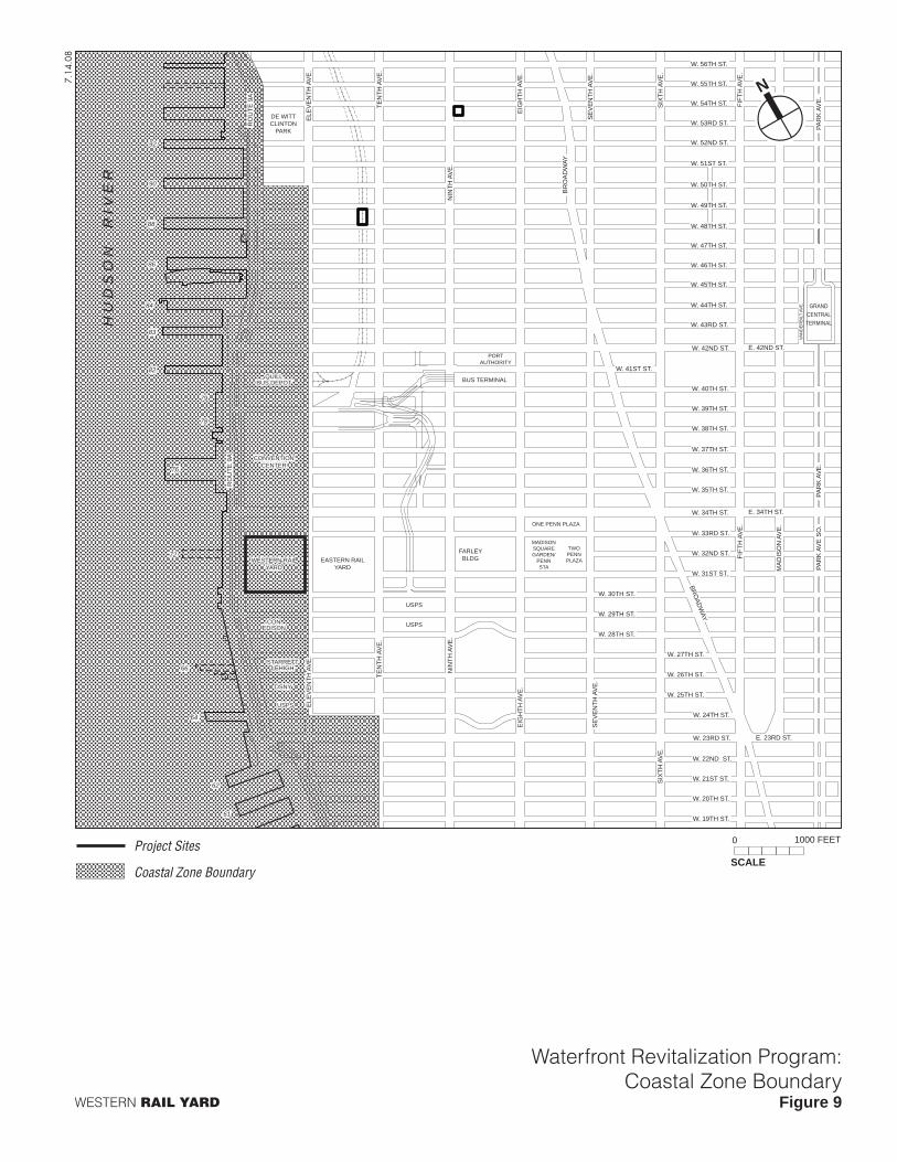
HU
DS
ON
RIV
ER
DE WITTCLINTON
PARK
W. 56TH ST.
W. 55TH ST.
W. 54TH ST.
NIN
TH A
VE.
TEN
TH A
VE.
ELEV
ENTH
AVE
.
W. 53RD ST.
W. 52ND ST.
W. 51ST ST.
W. 50TH ST.
W. 49TH ST.
W. 48TH ST.
W. 47TH ST.
W. 46TH ST.
W. 45TH ST.
W. 44TH ST.
W. 43RD ST.
W. 42ND ST.
EIG
HTH
AVE
.
SEVE
NTH
AVE
.
BRO
ADW
AY
W. 41ST ST.
W. 40TH ST.
W. 39TH ST.
W. 38TH ST.
W. 36TH ST.
W. 37TH ST.
W. 35TH ST.
W. 34TH ST.
W. 33RD ST.
W. 32ND ST.
W. 31ST ST.
W. 30TH ST.
W. 29TH ST.
W. 28TH ST.
W. 27TH ST.
W. 26TH ST.
W. 25TH ST.
W. 24TH ST.
W. 23RD ST.
NIN
TH A
VE.
TEN
TH A
VE.
RO
UTE
9A
RO
UTE
9A
ELEV
ENTH
AVE
.
EIG
HTH
AVE
.
SEVE
NTH
AVE
.
SIXT
H A
VE.
E. 23RD ST.FI
FTH
AVE
.
BROADW
AY
E. 42ND ST.
E. 34TH ST.
FIFT
H A
VE.
MAD
ISO
N A
VE.
PAR
K AV
E.PA
RK
AVE.
PAR
K AV
E SO
.
VAN
DER
BILT
AVE
.
MAD
ISO
N A
VE.
SIXT
H A
VE.
W. 22ND ST.
W. 21ST ST.
W. 20TH ST.
W. 19TH ST.
76
66
64
62
61
81
83
84
86
88
90
76
72
66
64
62
61
82
78
79
83
84
86
88
90
92
CONVENTIONCENTER
WESTERN RAILYARD
EASTERN RAILYARD
USPS
DSNY
USPS
USPS
STARRETTLEHIGH
QUILLBUS DEPOT
PORTAUTHORITY
BUS TERMINAL
MADISONSQUAREGARDEN/
PENNSTA
TWOPENNPLAZA
GRANDCENTRALTERMINAL
ONE PENN PLAZA
CONEDISON
7.14
.08
SCALE
0 1000 FEET
N
FARLEYBLDG
WESTERN RAIL YARD
Waterfront Revitalization Program:Coastal Zone Boundary
Figure 9
Project Sites
Coastal Zone Boundary
Draft Scope of Work
stormwater runoff. Proposed sustainable design measures to reduce water consumption, sewage generation, and stormwater management will be described.
DEP is currently preparing an Amended Drainage Plan for the Hudson Yards area, that will include the area generally bounded by: Route 9A to the west; West 46th to the north; West 27th Street to the south; and between Seventh and Tenth Avenues to the east. The wastewater and stormwater analyses described below will take into account the Amended Drainage Plan, as a No Build condition, and future changes to the combined and separate storm systems associated with the Amended Drainage Plan.
The analyses will include the following tasks:
WATER SUPPLY
A. Based on information obtained from the DEP, the existing water supply network and capacity of the distribution system that currently serves the area of the project sites will be described. Improvements to the water supply system that are expected to be implemented as part of the Hudson Yards Rezoning and Development Program and that relate to the Proposed Actions will also be identified.
B. Using water usage rates for typical land uses provided in the CEQR Technical Manual, an estimate of the water demand for conditions in the Future with and without the Proposed Actions will be estimated.
C. The potential for significant adverse impacts on the water supply system’s abilities to maintain adequate water supply and operating pressure, as a result of the Proposed Actions’ incremental water demand will be assessed. The potential reductions in water demand from proposed water conservation and sustainable measures will also be evaluated.
WASTEWATER
D. Based on information obtained from DEP, the existing sewer system serving the project sites will be described. The existing average and maximum monthly flows to the North River WPCP for the latest 12-month period will be provided.
E. Using the water demand determined in the task above and DEP projections, the sanitary sewage generation for conditions in the Future with and without the Proposed Actions will be estimated.
F. The potential for significant adverse impacts in terms of system conveyance and WPCP treatment capacity as a result of the Proposed Actions’ incremental sanitary sewage demands will be assessed. This evaluation would include a screening level assessment that compares the estimated stormwater and sanitary volumes and flows that would be discharged to the combined sewer under the Future with the Proposed Actions to the existing condition. If the screening indicates the need for further analyses, modeling would be conducted in consultation with DEP and in consideration of the results of the screening level assessment.
G. The compliance of the North River WPCP with its permit requirements, which are protective of the Hudson River water quality, will be discussed.
29
Western Rail Yard
STORMWATER
H. The existing storm and combined sewer system serving the project sites will be described. The description will include the major sewer lines and the location of existing CSO into the Hudson River.
I. Using DEP design criteria, stormwater runoff rates from the Proposed Actions will be calculated and compared to baseline conditions. Based on the project-generated runoff, analyses or modeling would be conducted in consultation with DEP, to identify the following: modifications to the storm and combined sewer infrastructure that may be required to accommodate project-generated runoff, resultant CSO events associated with this increased runoff, and stormwater management measures to be implemented as part of the Proposed Actions. If necessary, the EIS will provide an assessment and description of stormwater treatment technologies. The potential for significant adverse impacts on water quality in the Hudson River as a result of these changes will be assessed.
J. The potential reductions in stormwater runoff from proposed sustainable measures will be reflected in the analysis.
TASK 15. SOLID WASTE AND SANITATION SERVICES
This chapter of the EIS will assess the additional demands the Proposed Actions would place on solid waste disposal services based on the demand estimate generated by future residential, commercial, and community facility uses associated with the Proposed Actions. The analyses will include the following tasks:
A. The existing solid waste management services associated with the project sites will be described.
B. Using solid waste generation rates for typical land uses provided in the CEQR Technical Manual, an estimate of the solid waste demands for conditions in the Future with and without the Proposed Actions will be estimated.
C. The potential for significant adverse impacts on municipal and private sanitation services as a result of the Proposed Actions’ incremental solid waste demand will be assessed.
TASK 16. ENERGY
This chapter of the EIS will assess the additional demands the Proposed Actions would place on the energy supply. Any proposed sustainable measures to reduce energy consumption will be described. The analyses will include the following tasks:
A. Based on information obtained from Consolidated Edison, the existing energy distribution systems (electricity, natural gas, and steam) and estimated energy usage for existing conditions will be described.
B. Using energy usage rates for typical land uses provided in the CEQR Technical Manual, energy demands for conditions in the Future with and without the Proposed Actions will be estimated.
C. The potential for significant adverse impacts on energy distribution system capacities as a result of the incremental energy demand of the Proposed Actions will be assessed.
30
Draft Scope of Work
D. Any proposed energy saving contributions of implementing LEED certification or other sustainable design elements will also be described.
TASK 17. TRAFFIC AND PARKING
The EIS will provide a detailed assessment of potential traffic and parking impacts associated with the increased vehicular traffic and changes in the parking supply and demand resulting from the Proposed Actions. The study will include a description of existing conditions, projection of future transportation conditions, and identification of potential significant adverse impacts of the Proposed Actions at the Development Site and Additional Housing Sites.
The traffic and parking studies will include the following tasks:
A. Define traffic study areas. A preliminary study area has been defined, which encompasses West 42nd Street on the north, West 22nd Street on the south, Twelfth Avenue on the west, and Eighth Avenue on the east, with a portion extending to Sixth Avenue, and incorporates the trip generation associated with all components of the Proposed Actions (see Figure 10). The analysis locations will be determined based on final trip generation and assignments.
B. Develop baseline traffic networks. Baseline traffic volume networks will be developed for the traffic study area. These networks will be developed from primary data sources, such as the extensive manual turning movement, automatic traffic recorder (ATR), and vehicle classification counts conducted in the traffic study area over the past three years. The hours of peak traffic levels have been identified as 8 to 9 AM in the morning, noon to 1 PM in the midday, and 5 to 6 PM in the evening. A Saturday peak traffic level will also be identified for analysis, based on background and projected traffic levels generated by the Proposed Actions. Base year physical inventories of study area intersections will include the number of lanes, lane width, parking regulations, signal timing information (obtained from New York City Department of Transportation (NYCDOT)), and other general roadway characteristics.
C. Determine base year parking supply and usage characteristics. Baseline off-street parking supply and utilization within a quarter mile of the Development Site will be surveyed for the weekday midday and weekday overnight periods. If necessary, this study area could be expanded to a half mile to identify additional supply. On-street parking regulations will be inventoried within a quarter mile of the Development Site.
D. Conduct travel demand projections. Trip generation estimates for the Proposed Actions will be developed, incorporating both the development plan on the Development Site and the Additional Housing Sites. These estimates will be based on standard references, the CEQR Technical Manual, and a review of rates developed for similar uses from the No. 7 Subway Extension – Hudson Yards Rezoning and Development Program FGEIS and the ongoing Expanded Moynihan/Penn Station Redevelopment Project Supplemental Environmental Impact Statement (SEIS). Estimates of daily trips will be distributed for the weekday AM, midday, PM, and Saturday peak hours by travel mode. The peak hour trips by mode will also be assigned to the available modes of transportation. Trips associated with No Build projects will be similarly estimated.
E. Analyze baseline traffic operations. Level of service analyses will be conducted using the base year network traffic volumes to establish the existing conditions baseline for the Proposed Actions. The EIS will provide a detailed evaluation of existing traffic conditions—volume-to-capacity (v/c) ratios, average vehicle delays, and levels of service for each
31
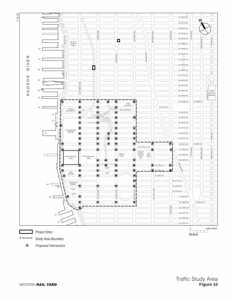
HU
DS
ON
RIV
ER
DE WITTCLINTON
PARK
W. 58TH ST.
W. 57TH ST.
W. 56TH ST.
W. 55TH ST.
W. 54TH ST.
NIN
TH A
VE.
TEN
TH A
VE.
ELEV
ENTH
AVE
.
W. 53RD ST.
W. 52ND ST.
W. 51ST ST.
W. 50TH ST.
W. 49TH ST.
W. 48TH ST.
W. 47TH ST.
W. 46TH ST.
W. 45TH ST.
W. 44TH ST.
W. 43RD ST.
W. 42ND ST.
EIG
HTH
AVE
.
SEVE
NTH
AVE
.
BRO
ADW
AY
W. 41ST ST.
W. 40TH ST.
W. 39TH ST.
W. 38TH ST.
W. 36TH ST.
W. 37TH ST.
W. 35TH ST.
W. 34TH ST.
W. 33RD ST.
W. 32ND ST.
W. 31ST ST.
W. 30TH ST.
W. 29TH ST.
W. 28TH ST.
W. 27TH ST.
W. 26TH ST.
W. 25TH ST.
W. 24TH ST.
W. 23RD ST.
NIN
TH A
VE.
TEN
TH A
VE.
RO
UTE
9A
RO
UTE
9A
EIG
HTH
AVE
.
SEVE
NTH
AVE
.
SIXT
H A
VE.
E. 23RD ST.
FIFT
H A
VE.
BROADW
AY
CENTRAL PARK SOUTH
E. 42ND ST.
E. 34TH ST.
FIFT
H A
VE.
MAD
ISO
N A
VE.
PAR
K AV
E.PA
RK
AVE.
PAR
K AV
E SO
.
VAN
DER
BILT
AVE
.
MAD
ISO
N A
VE.
SIXT
H A
VE.
W. 22ND ST.
W. 21ST ST.
W. 20TH ST.
W. 19TH ST.
76
66
64
62
61
81
83
84
86
88
90
76
72
66
64
62
61
82
78
79
83
84
86
88
90
92
CONVENTIONCENTER
WESTERN RAILYARD
EASTERN RAILYARD
USPS
DSNY
USPS
USPS
STARRETTLEHIGH
QUILLBUS DEPOT
PORTAUTHORITY
BUS TERMINAL
MADISONSQUAREGARDEN/
PENNSTA
TWOPENNPLAZA
GRANDCENTRALTERMINAL
ONE PENN PLAZA
CONEDISON
7.28
.08
SCALE
0 1000 FEET
N
FARLEYBLDG
WESTERN RAIL YARDTraffic Study Area
Figure 10
Project Sites
Study Area Boundary
Proposed Intersection
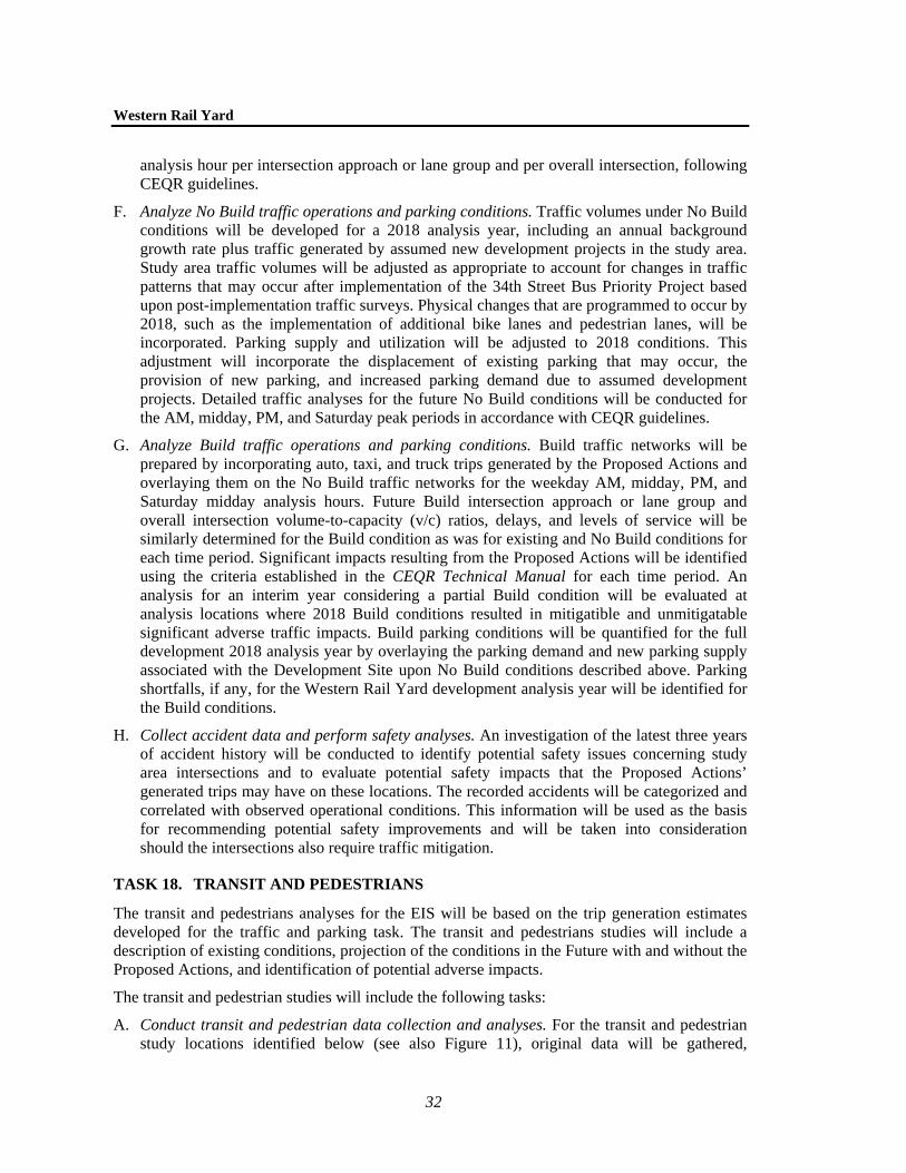
Western Rail Yard
analysis hour per intersection approach or lane group and per overall intersection, following CEQR guidelines.
F. Analyze No Build traffic operations and parking conditions. Traffic volumes under No Build conditions will be developed for a 2018 analysis year, including an annual background growth rate plus traffic generated by assumed new development projects in the study area. Study area traffic volumes will be adjusted as appropriate to account for changes in traffic patterns that may occur after implementation of the 34th Street Bus Priority Project based upon post-implementation traffic surveys. Physical changes that are programmed to occur by 2018, such as the implementation of additional bike lanes and pedestrian lanes, will be incorporated. Parking supply and utilization will be adjusted to 2018 conditions. This adjustment will incorporate the displacement of existing parking that may occur, the provision of new parking, and increased parking demand due to assumed development projects. Detailed traffic analyses for the future No Build conditions will be conducted for the AM, midday, PM, and Saturday peak periods in accordance with CEQR guidelines.
G. Analyze Build traffic operations and parking conditions. Build traffic networks will be prepared by incorporating auto, taxi, and truck trips generated by the Proposed Actions and overlaying them on the No Build traffic networks for the weekday AM, midday, PM, and Saturday midday analysis hours. Future Build intersection approach or lane group and overall intersection volume-to-capacity (v/c) ratios, delays, and levels of service will be similarly determined for the Build condition as was for existing and No Build conditions for each time period. Significant impacts resulting from the Proposed Actions will be identified using the criteria established in the CEQR Technical Manual for each time period. An analysis for an interim year considering a partial Build condition will be evaluated at analysis locations where 2018 Build conditions resulted in mitigatible and unmitigatable significant adverse traffic impacts. Build parking conditions will be quantified for the full development 2018 analysis year by overlaying the parking demand and new parking supply associated with the Development Site upon No Build conditions described above. Parking shortfalls, if any, for the Western Rail Yard development analysis year will be identified for the Build conditions.
H. Collect accident data and perform safety analyses. An investigation of the latest three years of accident history will be conducted to identify potential safety issues concerning study area intersections and to evaluate potential safety impacts that the Proposed Actions’ generated trips may have on these locations. The recorded accidents will be categorized and correlated with observed operational conditions. This information will be used as the basis for recommending potential safety improvements and will be taken into consideration should the intersections also require traffic mitigation.
TASK 18. TRANSIT AND PEDESTRIANS
The transit and pedestrians analyses for the EIS will be based on the trip generation estimates developed for the traffic and parking task. The transit and pedestrians studies will include a description of existing conditions, projection of the conditions in the Future with and without the Proposed Actions, and identification of potential adverse impacts.
The transit and pedestrian studies will include the following tasks:
A. Conduct transit and pedestrian data collection and analyses. For the transit and pedestrian study locations identified below (see also Figure 11), original data will be gathered,
32
DE WITTCLINTON
PARK
W. 55TH ST.
W. 54TH ST.
NIN
TH A
VE.
TEN
TH A
VE.
ELEV
ENTH
AVE
.
W. 53RD ST.
W. 52ND ST.
W. 51ST ST.
W. 50TH ST.
W. 49TH ST.
W. 48TH ST.
W. 47TH ST.
W. 46TH ST.
W. 45TH ST.
W. 44TH ST.
W. 43RD ST.
W. 42ND ST.
EIG
HTH
AVE
.
SEVE
NTH
AVE
.
BRO
ADW
AY
W. 41ST ST.
W. 40TH ST.
W. 39TH ST.
W. 38TH ST.
W. 36TH ST.
W. 37TH ST.
W. 35TH ST.
W. 34TH ST.
W. 33RD ST.
W. 32ND ST.
W. 31ST ST.
W. 30TH ST.
W. 29TH ST.
W. 28TH ST.
W. 27TH ST.
W. 26TH ST.
W. 25TH ST.
W. 24TH ST.
W. 23RD ST.
NIN
TH A
VE.
TEN
TH A
VE.
RO
UTE
9A
RO
UTE
9A
ELEV
ENTH
AVE
.
EIG
HTH
AVE
.
SEVE
NTH
AVE
.
SIXT
H A
VE.
E. 23RD ST.
FIFT
H A
VE.
BROADW
AY
FIFT
H A
VE.
MAD
ISO
N A
VE.
PAR
K AV
E.PA
RK
AVE.
PAR
K AV
E SO
.
VAN
DER
BILT
AVE
.
MAD
ISO
N A
VE.
SIXT
H A
VE.
W. 22ND ST.
W. 21ST ST.
76
66
64
62
81
83
84
86
88
90
76
72
66
64
62
82
78
79
83
84
86
88
90
92
CONVENTIONCENTER
WESTERN RAILYARD
EASTERN RAILYARD
USPS
DSNY
USPS
USPS
STARRETTLEHIGH
QUILLBUS DEPOT
PORTAUTHORITY
BUS TERMINAL
MADISONSQUAREGARDEN/
PENNSTA
TWOPENNPLAZA
GRANDCENTRALTERMINAL
ONE PENN PLAZA
CONEDISON
M11
M11
M11
M11
M42
M34
M34
M42
M42
M42 M42
M34M34
M34
M34
1
2
3
4
5
6
7
8
9
10
11
12
13
15
16
14
7.14
.08
N
FARLEYBLDG
WESTERN RAIL YARDPedestrian Analysis Locations
Figure 11
SCALE
0 600 1500 FEETProject Sites
Corner and Crosswalk Locations
Midblock Sidewalk Locations
Bus Line RoutesM34
1
Draft Scope of Work
supplemented with information developed as part of other studies, in accordance with CEQR guidelines, to develop existing baseline conditions. As with traffic and parking, detailed future conditions analyses will be conducted for the weekday AM, midday (pedestrian analyses only), and PM peak periods, and Saturday peak periods (pedestrian analyses only).
B. Assess transit conditions. The transit analysis will include a description of nearby transit facilities and a characterization of subway and bus ridership levels. Transit service to the project sites is available via NYCT subways and buses. Based on the CEQR Technical Manual, detailed analyses will be required if the Proposed Actions would generate 200 or more peak hour trips at a particular subway station (street stairways and control areas) or bus route. Given the scale of the Proposed Actions, it is expected that a detailed assessment, including operational analyses of street stairways and control areas, will be required for 34th Street (two existing stations at Eighth and Seventh Avenues and one new station for the No. 7 Line at Eleventh Avenue). A line-haul assessment will be provided for the No. 7 Line. In addition, bus capacity analysis will be conducted for six bus routes (M34, M42, M10, M11, M16, and M20).
C. Assess pedestrian conditions. The Proposed Actions will generate pedestrian traffic along likely routes between the project sites and connecting transit service, and the adjacent neighborhoods. Based on the CEQR Technical Manual, detailed analyses will be required where the Proposed Actions would generate 200 or more peak hour trips at a particular pedestrian element. Quantified analysis of sidewalk, crosswalk, and corner conditions will be conducted in the immediate vicinity of the Development Site, focusing on conditions along major pedestrian corridors, such as 34th Street and Ninth and Tenth Avenues and other key locations in accordance with the CEQR Technical Manual.
TASK 19. AIR QUALITY
The Proposed Actions would result in residential uses on blocks where residences are not currently allowed and alter traffic conditions in the study area. Analyses would be performed to determine the potential impacts of the Proposed Actions on the surrounding land uses as well as the impacts of surrounding land uses on the Proposed Actions. The key issues that will be addressed are the potential for (1) significant adverse air quality impacts from increases in the number of vehicles on the local traffic network as a result of the project, and the accompanying reduction in vehicular speeds; (2) impacts from proposed parking facilities (lots, garages); (3) emissions from the heating, ventilation and air conditioning (HVAC) systems of the proposed development buildings to significantly impact existing land uses and other proposed development buildings (project-on-project impacts); (4) combined impacts from HVAC emissions of the clusters of proposed development buildings (if proposed developments are located in close enough proximity to one another) to significantly impact existing land uses and proposed development sites; (5) significant adverse air quality impacts from the HVAC systems of existing “major” commercial, institutional, and large-scale residential emission sources with 20 million Btu/hr heat input or more on the proposed development sites; and (6) impacts on the proposed development sites from air toxic emissions generated by nearby existing industrial sources.
The EIS will also discuss the Proposed Project’s energy efficiencies and other measures to reduce greenhouse gas emissions; the Proposed Project’s consistency with the relevant policies of PlaNYC, and any effects climate change may have on the Proposed Project.
33
Western Rail Yard
MOBILE SOURCE ANALYSIS
The mobile source analysis will take into account the potential for increased traffic associated with the Proposed Actions to affect local air quality levels. Emissions generated by project-generated traffic at congested intersections could potentially and significantly affect air quality levels at nearby sensitive land uses. The primary issue related to the proposed development is whether traffic associated with the project would cause or exacerbate a violation of the 8-hour National Ambient Air Quality Standard National Ambient Air Quality Standards (NAAQS) for carbon monoxide (CO) or the 24-hour NAAQS for particulate matter smaller than 10 microns (PM10). A determination will also be made as to whether project-generated vehicles would cause an exceedance of the NYC de minimis criteria for CO or a significant threshold value (STV) established by DEC and DEP for PM2.5.
A. Screening Analysis. A screening level analysis will be conducted to identify sites for detailed evaluation. This analysis will estimate the potential for the Proposed Actions to significantly impact air quality levels near these sites based on projected Build and No Build traffic volumes, levels of service, and surrounding land uses. A volume threshold of 75 additional project-related vehicles through an intersection, as defined by the CEQR screening guidelines for this study area, will be utilized to select analysis sites.
B. Sites for Detailed Analysis. Air quality analysis sites for detailed analysis will be selected based on the results of the screening level analysis and ranked according to the results of the traffic evaluation based on levels of service, total approach volumes, operating speeds, etc. These sites will include locations of critical roadway links and heavily congested intersections adjacent to sensitive land uses that may be affected by the traffic generated by the proposed developments. It is assumed that up to 10 “worst-case” air quality sites will be selected for detailed analysis.
C. CO Dispersion Analysis. A detailed microscale mobile source analysis will be conducted using CEQR procedures to estimate potential impacts near congested locations. This analysis will employ the EPA CAL3QHCR (Version 2) dispersion model and the latest EPA emission factor algorithm (currently MOBILE 6.2) with the latest DEC local input data. Intersection geometries will be developed for each analysis site. Analyses will be conducted using the latest five consecutive years of meteorological data from LaGuardia Airport (2002-2006).
D. Modeling inputs appropriate for the study area, as well as background levels, will be obtained from the DEC and DEP. The methodology and input parameters needed to compute emission source strengths will be selected. Proper credits to account for the State’s inspection and maintenance and anti-tampering programs, the recently revised vehicles registration data that includes SUVs, and other inputs will be incorporated.
E. Four peak-hour time periods will be modeled at each location—weekday AM, midday, and PM peak periods, and a Saturday weekend peak period. CO levels will be estimated at approximately 20 air quality receptors near each analysis site and the highest levels predicted at any of these locations would be reported as being the maximum levels for the analysis site as a whole for each time period.
F. CO levels will be estimated at each of the analysis sites for existing conditions and future No Build and Build conditions. Maximum one- and eight-hour CO concentrations will be calculated for each condition.
34
Draft Scope of Work
G. Estimated eight-hour CO levels will be compared with NAAQS, and project-generated impacts will be compared with the NYC de minimis levels. The possibility of attaining ambient air quality standards at sites where exceedances are predicted by incorporating measures as part of the project will be examined. Analyses will be conducted, where necessary, using measures designed to minimize potential significant adverse impacts of the Proposed Actions.
H. PM10/PM2.5 Dispersion Analysis. Detailed PM10/PM2.5 mobile source analyses will be conducted, following procedures provided in the CEQR Technical Manual, DEC’s Commissioner’s Policy (CP) No. 33, and DEP’s Interim PM2.5 Guidance. This analysis will be conducted at up to five intersections and these intersections will be selected based on worst-case results of the CO analysis and location of the highest project generated vehicular trips. Future Build and future No Build 24-hour PM10 levels and annual and 24-hour PM2.5 levels will be estimated. Resulting 24-hour PM10 levels will be compared to the applicable NAAQS; incremental changes in 24-hour and annual PM2.5 levels will be compared to STVs, as defined by DEC’s CP 33 Guidelines and DEP’s Interim PM2.5 Guidance, to determine the potential for significant adverse impacts. The CAL3QHCR model with the latest five years of meteorological data (2002-2006) from LaGuardia Airport will be used.
PARKING FACILITIES ANALYSIS
I. Proposed parking facilities on the Development Site will be analyzed according to CEQR guidelines. Analyses will be based on the worst-case peak period for parking facilities, which is typically the hour that has the highest number of exiting vehicles. Exiting vehicles, which are in cold-start mode, have higher CO emissions than arriving vehicles. Vehicular emission factors will be obtained from MOBILE 6.2. Receptor points will be located at the near and far sidewalks of the parking facilities and at adjacent sensitive land uses.
J. CO impacts from nearby roadway traffic emissions will be added to the estimated parking facility impacts and to appropriate background values, and the total estimated concentrations will be compared to the NAAQS.
STATIONARY SOURCE ANALYSES
The HVAC analysis will include the following tasks:
K. In accordance with CEQR guidelines, screening-level analyses will be conducted, and followed, if necessary, by detailed dispersion analyses to determine compliance with applicable air quality standards and guidelines.
L. The potential for emissions from the HVAC systems of the proposed buildings at both the Development Site and Additional Housing Sites (and the ventilation exhaust associated with the Western Rail Yard’s platform, if any), to significantly impact existing land uses and other proposed development buildings (project-on-project impacts) will be analyzed. The areas within a 400-foot radius of each of the project sites will be examined to determine whether buildings the same height or taller than the proposed developments exist near these sites. The nomographic method will be applied to determine whether the HVAC emissions of each of the proposed buildings would have the potential to significantly impact nearby existing buildings or other proposed buildings (i.e., project-on-project impacts).
M. If results of Task L exceed the nomographic threshold values, detailed analyses will be conducted using the EPA’s AERMOD dispersion model. NO2, SO2, PM10, and PM2.5 will be
35
Western Rail Yard
considered for detailed stationary source analyses. Short-term (i.e., 3- and 24-hour) and long-term (i.e., annual) concentrations of NO2, SO2, and PM10 will be estimated. Analyses will be conducted with and without building downwash using the latest five consecutive years of meteorological data from LaGuardia Airport. Building fuel consumption rates will be estimated using factors presented in Appendix No. 7 of the CEQR Technical Manual. The combined impacts of emissions from the proposed buildings (including clusters of buildings of similar heights) on nearby existing or proposed buildings will also be estimated.
N. Potential impacts of emissions from existing “major” commercial, institutional, and large-scale residential emission sources (e.g., HVAC systems with 20 or more MMBtu/hr heat input) within a 1,000-foot radius of each of the development sites on the proposed developments will be estimated. A detailed analysis will be conducted using EPA’s AERMOD dispersion model. Building fuel consumption rates will be estimated using factors presented in Appendix No. 7 of the CEQR Technical Manual and adjusted using annual load factors. Emission factors for the pollutants of concern will be obtained from EPA’s “Compilation of Air Pollutant Emission Factors” (AP-42) based on the fuel types to be used in each building. Stack parameters (i.e., temperatures, stack diameters, exit velocities, etc.) will be obtained, to the extent available, from the DEP-BEC Permit Information Database. If no data are available, stack parameters will be estimated based on building sizes and heat inputs and default CEQR Technical Manual values. Analyses will be conducted with and without building downwash using the latest five consecutive years of meteorological data from LaGuardia Airport.
O. Estimated short-term and annual SO2, PM10, and NOx concentrations will be added to appropriate background levels, and total pollutant concentrations will be compared with NAAQS to determine whether there will be a potential for a violation of these standards. Maximum incremental PM2.5 impacts will be compared with DEP and DEC STVs to determine whether these impacts would be considered significant. Mitigation measures will be identified, where necessary, to achieve compliance with the NAAQS and STVs.
P. An additional examination will be conducted to determine if large combustion emission source (e.g., power plants, co-generation facilities, etc.) are located within and beyond 1,000 feet of the project sites. Potential impacts of these sources, if any, on the Proposed Actions’ buildings will be estimated using detailed analyses and EPA’s AERMOD dispersion model.
Potential impacts of toxic air emissions from nearby existing industrial sources on the proposed developments will be estimated. The analysis process will be conducted as follows:
Q. Analysis areas within a 400-foot radius of each of the project sites will be determined.
R. Air permits for all facilities within these analysis areas on DEC’s Air Permit Facilities registry, DEP-BEC New York City Clean Air Tracking Database, and EPA’s Facility Registry System will be acquired and reviewed.
S. Screening level dispersion analyses will be conducted to determine the potential of the toxic emissions released from the permitted emission sources to significantly impact the new development sites. Dispersion modeling analyses will initially be conducted using DEC’s DAR-1 data base and dispersion models to determine whether the air toxic emissions from existing currently operating permitted facilities within the air toxics study areas have the potential to exceed short-term or annual health-related guideline values (i.e., short-term guideline concentrations [SGCs] or annual guideline concentrations [AGCs]). Impacts of both carcinogenic and non-carcinogenic toxic air pollutants will be estimated using unit risk
36
Draft Scope of Work
factors and hazard index approach. A more refined analysis, using the AERMOD model, will then be conducted to estimate potential impacts for any pollutants and facilities that fail the screening level analysis.
TASK 20. NOISE
The noise analysis will consider the impact of noise generated by the Proposed Actions’ generated traffic and re-routed vehicular traffic. The noise study will evaluate the following: (1) changes in traffic noise levels as a result of the Proposed Actions; and (2) achievement of acceptable interior noise levels at the project sites. Existing noise levels will be determined by monitoring future residential or other locations. Future noise levels will be estimated based on the proportionate change in traffic volume between existing and future conditions.
The EIS noise study would include the following tasks performed in compliance with guidelines contained in the CEQR Technical Manual:
A. Site Selection. A preliminary review of the study area has identified 15 potential noise monitoring and impact assessment locations. Final selection of noise monitoring sites will be based on project-generated vehicle trip generation and network assignment. In general, receptor sites for noise monitoring and impact analysis will consist of two primary noise sensitive categories of properties:
Sites representative of noise-sensitive locations within the vicinity of the project sites, such as new residences, hotel developments, and open space, taking into consideration anticipated future land uses.
Existing noise sensitive land uses such as existing churches, hospitals, libraries, schools, parks (possibly including the Hudson River Park and proposed High Line Park), hotels and residential buildings, that may potentially be adversely impacted by the operation of the Proposed Project.
In summary, two types of noise monitoring sites will be selected: sites where the Proposed Actions would have the potential for significant impacts due to project-generated traffic, and sites that can be used to determine the building attenuation necessary to comply with noise regulations.
B. Data collection. At the identified noise monitoring locations existing noise levels will be measured for 20-minute durations as per CEQR Technical Manual guidelines. Appropriate noise descriptors such as the equivalent noise level (Leq) and statistical percentile noise levels (Lmax, Lmin, L1, L10, L50, L90) will be recorded during each measurement. The noise levels will be measured in units of “A” weighted decibels (dBA). At each measurement site, the monitoring time periods will coincide with weekday AM (8 to 9 AM), midday (12 to 1 PM), and PM (5 to 6 PM), and Saturday (12 to 1 PM) peak traffic noise periods.
C. Equipment. As needed, the analysis will utilize noise recording instrumentation consisting of calibrators, microphones, and sound level meters from Larson Davis and Brüel & Kjaer (or equivalent), all of which would comply with American National Standards Institute (ANSI) S1.4 Standard for Type 1 or 2 accuracy requirements. A porous windscreen will be used during all measurement periods. All of the noise measurements will be taken by mounting the meter approximately five feet above the ground surface at that location. This height is generally considered representative of the ear level of an average person. All noise
37
Western Rail Yard
monitoring would be conducted under dry weather conditions with wind speeds below 15 mph.
D. Analysis Year Noise Level Estimates. Following procedures outlined in the CEQR Technical Manual future no-action and project-related noise levels will be estimated at each of the noise monitoring locations. To determine future 2018 No Build and Build noise levels, the analysis of noise from mobile sources will employ the Passenger Car Equivalent (PCE) screening methodology provided in the CEQR Technical Manual. Using this procedure, future noise levels can be estimated from the following formula:
⎟⎟⎠
⎞⎜⎜⎝
⎛⋅+=
CEsExisting PsFuture PCE (dBA)oise LevelExisting NdBA)se Level (Future Noi log10
Sites identified where PCE doubling is projected to occur would be further analyzed in more detail utilizing the Federal Highway Administration (FHWA) Traffic Noise Model (TNM) version 2.5. The hourly l10 and Leq noise indices will be used to characterize all traffic noise in the analysis.
E. Noise Criteria. CEQR mobile noise criteria will be followed, while determining project impacts at the future sensitive sites. The criteria will take into consideration the indoor and outdoor areas at the monitored sites, which are representative of noise-sensitive land uses in the area.
F. Analysis Year Noise Impacts. At each receptor site, noise impacts will be determined by estimating the projected incremental change in noise levels between future No Build and Build conditions. Build noise levels will be compared with CEQR noise exposure guidelines and the NYC Noise Code.
G. Noise Abatement Analysis. At locations where noise abatement may be required, appropriate mitigation measures will be considered in accordance with the CEQR guidelines and recommendations for their implementation will be made. Future residential/commercial buildings, where mitigation may be required as a result of the Proposed Actions, may receive an E-designation to ensure that window/wall noise attenuation is provided to comply with acceptable interior noise requirements.
TASK 21. CONSTRUCTION
The EIS will assess potential construction-related impacts from all activities associated with construction of the Proposed Actions. The likely construction schedule and an estimate of activity on-site will be described. The EIS will include quantitative analyses of potential traffic and transportation, air quality, and noise impacts. For the purposes of analyzing the reasonable worst-case development scenarios for construction, construction impacts will be evaluated when maximum potential impacts are expected during construction activity on the project sites. As appropriate, some of the construction analyses, such as air quality, will also address the effect of the Proposed Actions during the period when the highest cumulative construction activities associated with the project sites and other construction projects near the project sites are expected.
Technical areas to be analyzed in the construction analysis include:
A. Traffic and Transportation Systems. Consider any temporary or partial losses in streets, lanes, walkways, parking, and other transportation services; increases in vehicles from construction
38
Draft Scope of Work
workers and truck deliveries; and any temporary maintenance and protection of traffic (MPT) modifications to street operations. Analyze potential temporary impacts to the transportation systems surrounding the project sites. The effects on traffic operations during construction will focus on the intersections in close proximity to the project sites.
B. Air Quality. Analyze direct emissions from demolition and construction site activity, including fugitive dust and on-site diesel equipment. Analyze potential effects from increases in mobile source emissions of trucks and worker vehicles at nearby sensitive receptors and congested locations, and from potential traffic diversions. Discuss measures and emission reduction strategies to mitigate any significant adverse impacts.
C. Noise and Vibration. Noise generated from the construction activity on nearby sensitive receptors will be determined utilizing the CadnaA model. Based on a review of the proposed major construction activity zones, up to ten noise sensitive receptor locations will be identified for impact assessment. At each location, worst-case noise from construction activities will be determined. Construction noise impacts will be assessed using relevant CEQR criteria. In addition, vibration generated by construction activities which could potentially cause damage to nearby buildings and other resources will be assessed utilizing the Federal Transit Administration (FTA) screening methodology. Potential vibration impacts will be evaluated using relevant FTA vibration impact thresholds.
D. Hazardous Materials. In coordination with the work performed for the hazardous materials task, above, summarize actions to be taken during construction to limit exposure of construction workers, residents, and the environment to potential contaminants. This would include the implementation of a construction health and safety plan (CHASP), which would require approval by DEP, and would be based on the results of subsurface testing (soil and groundwater analyses).
E. Historic Resources. The integrity of nearby historic resources within and adjacent to the project site could be adversely affected by construction vibrations; thus, the maintenance of the integrity of such resources would need to be assessed.
F. Socioeconomic Conditions. Assess effects on local business operations as a result of construction activities at the project site.
G. Other Technical Areas. As appropriate, discuss the other areas of environmental assessment for potential construction-related impacts.
TASK 22. PUBLIC HEALTH
According to the guidelines of the CEQR Technical Manual, public health concerns for which an assessment may be warranted include: increased vehicular traffic or emissions from stationary sources resulting in significant adverse air quality impacts; increased exposure to heavy metals and other contaminants in soil/dust resulting in significant adverse hazardous materials or air quality impacts; the presence of contamination from historic spills or releases of substances that might have affected or might affect ground water to be used as a source of drinking water; solid waste management practices that could attract vermin and result in an increase in pest populations; potentially significant adverse impacts to sensitive receptors from noise and odors; and actions for which any potential impacts result in an exceedance of accepted federal, State, or local standards. Drawing on other EIS sections, this task will assess and summarize the potential for significant adverse impacts on public health from activities associated with the Proposed Actions.
39
Western Rail Yard
TASK 23. ENVIRONMENTAL JUSTICE
For the purposes of the possible DEC permit approvals, an analysis will be provided that considers the potential for disproportionately high and adverse human health or environmental effects of the project on minority or low-income populations. This analysis will be conducted in accordance with CP-29, Environmental Justice and Permitting (the “Policy”), issued by DEC on March 19, 2003.
TASK 24. MITIGATION
Where significant adverse impacts are identified in the analyses discussed above, any practicable measures that have the potential to avoid or mitigate those impacts will be identified and analyzed. This task summarizes the findings of the relevant analyses and discusses potential mitigation measures. Where impacts cannot be mitigated, they will be identified as unavoidable significant adverse impacts. The EIS will also describe the anticipated schedule for the implementation of specific mitigation measures.
TASK 25. ALTERNATIVES
The purpose of an alternatives analysis in an EIS is to examine development options that would reduce or eliminate project generated significant adverse impacts while achieving the stated goals and objectives of the Proposed Actions. The specific alternatives to be analyzed are typically finalized as project impacts become clarified. However, they will include a No Action Alternative, which assumes that the Proposed Actions are not approved and the project sites remains in their current uses, a Reduced Density Alternative, a No Unmitigated Significant Adverse Impact Alternative, and an alternative that considers an on-site energy generating facility (which would require permits from the DEC and DEP). The description and evaluation of each alternative will be provided at a level of detail sufficient to permit a comparative assessment of each alternative discussed.
TASK 26. EIS SUMMARY CHAPTERS
The EIS will include the following three summary chapters, where appropriate, in accordance with CEQR guidelines.
• Unavoidable Significant Adverse Impacts This chapter will summarize any significant adverse impacts that are unavoidable if the Proposed Actions are implemented regardless of the mitigation employed (or if mitigation is unfeasible);
• Growth-Inducing Aspects of the Proposed Actions. This chapter will assess the potential for the proposed actions to result in “secondary” impacts that trigger further development.
• Irreversible and Irretrievable Commitment of Resources. This chapter will provide an overview of the short- and long-term impacts of the Proposed Actions in terms of the loss of environmental resources (use of fossil fuels and materials for construction, loss of vegetation, etc.).
TASK 27. EXECUTIVE SUMMARY
The executive summary will use relevant material from the body of the EIS to describe the Proposed Actions, the necessary approvals, study areas, environmental impacts predicted to
40
Draft Scope of Work
41
occur, measures to mitigate those impacts, unmitigated and unavoidable impacts (if any), and alternatives to the Proposed Actions.