Embed Size (px)
Citation preview

Western Sydney Aerotropolis
What We HeardCommunity Consultation Report
Acknowledgement
The planning for the Western Sydney Aerotropolis acknowledges more than 40,000 years of continuous Aboriginal connection to the land that makes up NSW.
This Plan recognises that, as part of the world’s oldest living culture, traditional Aboriginal and Torres Strait Islander owners and custodians of the Australian continent and adjacent islands share a unique bond to Country — a bond forged through thousands of years of travelling across lands and waterways for ceremony, religion, trading and seasonal migration.
To view an electronic version in PDF format, visit: www.wscd.sydney/planning-partnership www.planning.nsw.gov.au
© Crown Copyright 2019
NSW State Government Released September 2019
Disclaimer
While every reasonable effort has been made to ensure that this document is correct at the time of printing, the State of New South Wales, its agents and employees, disclaim any and all liability to any person in respect of anything or the consequences of anything done or omitted to be done in reliance or upon the whole or any part of this document.
Copyright Notice
In keeping with the Western Sydney Planning Partnership’s commitment to encourage the availability of information, you are welcome to reproduce the material that appears in this Planning Report for personal, in-house or non-commercial use without formal permission or charge. All other rights are reserved. If you wish to reproduce, alter, store or transmit material appearing in this Planning Report for any other purpose, a request for formal permission should be emailed to:
You are required to acknowledge that the material is provided by The Partnership or the owner of the copyright as indicated in this Planning Report and to include this copyright notice and disclaimer in any copy. You are also required to acknowledge the author (the Western Sydney Planning Partnership) of the material as indicated in this Planning Report.

Contents
About this report 2
Engagement approach 4
Submission analysis 5
Social Pinpoint map 6
Key themes 8
South Creek – Wianamatta Precinct 10
Agriculture and Agribusiness Precinct 15
Precinct boundaries and sequencing 18
Airport impacts 20
Transport and access 22
Agency, industry and site specific submissions 24
The way forward 28

About this report
This report details the consultation on the Stage 1 Western Sydney Aerotropolis Land Use and Infrastructure Implementation Plan (Stage 1 LUIIP), released by the Department of Planning, Industry and Environment (the Department) to kickstart the conversation with the community and industry around the Western Sydney Aerotropolis.
This report consists of three sections:
What you told us
Clarification of the Stage 1 LUIIP
Commitment to how we are moving forward
From 21 August to 2 November 2018, the Department exhibited the Stage 1 Land Use and Infrastructure Implementation Plan (Stage 1 LUIIP) for the Western Sydney Aerotropolis.
The consultation process provided the community, the development industry, educational institutions and organisations opportunity to participate in the future planning for the Western Sydney Aerotropolis. This report summarises feedback received during the consultation process. It does not provide detailed responses but aims to acknowledge key themes, clarify central concerns and outline our commitments as planning for the Aerotropolis continues.
Responsibility for planning for the Aerotropolis has now been given to the Western Sydney Planning Partnership (Planning Partnership).
Through a continued consultation process, the Planning Partnership will establish and strengthen relationships with the community, so that people can continue to provide feedback as plans are developed and further refined. The consultation on the Stage 1 LUIIP was the start of a journey, not the end of one.
Who is the Western Sydney Planning Partnership?The Western Sydney Planning Partnership is a local government-led initiative that brings together the councils of Blacktown, Blue Mountains, Camden, Campbelltown, Fairfield, Hawkesbury, Liverpool, Penrith and Wollondilly and key NSW government agencies to achieve more efficient and higher quality outcomes for Western Sydney through innovative and collaborative planning.
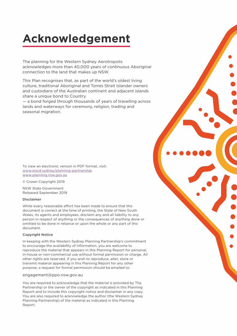
The Stage 1 LUIIP• provides a Structure Plan that outlines proposed
land uses for the three initial precincts of Aerotropolis Core, the Northern Gateway and South Creek
• promotes the creation of new communities
• recognises that the operation of a world-class, 24-hour/seven-day a week international airport is crucial to the success of the Western Parkland City
• identifies the potential for the Aerotropolis to make a significant contribution to 200,000 new jobs for Western Sydney and up to 60,000 new homes
• promotes a landscape-led approach for the Western Parkland City, in line with the Western City District Plan
• describes how the Aerotropolis contributes to the vision of the Western Parkland City as part of the Metropolitan Cluster, which also includes Greater Penrith, Liverpool and Campbelltown–Macarthur.
2 Western Sydney Aerotropolis
!T
M9
M12
LEPPINGTON
Fifteenth Avenue
Ludd
enha
m R
oad
Bringelly Road
NorthLuddenham
AerotropolisCore
AerotropolisCore
Agricultureand
Agribusiness
NorthernGateway
BadgerysCreek
Rossmore
MamreRoad
KempsCreek
KempsCreek
SouthCreek
WesternSydneyAirport
Camde
n Valley W
TheNorthern Road
Elizabeth Drive
Mam
re Road
Park Road
Precinct BoundaryWestern Sydney AirportProposed Transport Corridors
AgriculturalLuddenham VillageFlexible EmploymentUrban Land
Non Urban LandMixed Flexible Employment &Urban Land
0 1 20.5
KilometresWestern Sydney AerotropolisStructure Plan (as exhibited)
N
Source: Western Sydney Aerotropolis Land Use and Infrastructure Implementation Plan – Stage 1: Initial Precincts, page 19

Engagement approach
The Department exhibited the Stage 1 LUIIP between 21 August and 2 November 2018. The engagement process aimed to:
1. Raise awareness of the Plan
2. Seek feedback on the Plan
3. Share feedback to all who are involved in the Aerotropolis.
Engagement was aimed at people who live and do business in the Aerotropolis and in neighbouring areas, as well as future communities and businesses. The Department also sought feedback from councils, Australian and State agencies, the development industry and other stakeholders.
The engagement involved:
• Three drop in sessions for stakeholders – two in Bringelly and one in Luddenham – to launch the exhibition, to provide information to help with submissions, and to seek initial feedback on the plans in person.
• Over 40 one-on-one meetings with landowners and industry to discuss issues in more detail.
• Five community group meetings with the South Creek Precinct Group, Aerotropolis Agribusiness Action Group, Willowdene Avenue residents’ group, Badgerys Creek residents’ group and Kemps Creek residents’ group.
• Two public meetings with the Luddenham Progress Association and Liverpool Rural Land Forum to discuss issues relevant to specific communities.
• Phone calls from the public were taken by a five-person team.
• Informal sources including survey responses and social media comments.
10 Weeks of public engagement
608Submissions received
Engagement approaches
1,906 Letters posted
5Advertisements in local and metropolitan newspapers
1,062People registered for email updates
36,164Website visits
Feedback received
3Drop-in sessions, attended by over 900 people
40Meetings with landowners and industry
5Meetings with different community groups
250+Telephone calls received
222Online surveys completed
137Comments on the Social Pinpoint map
4 Western Sydney Aerotropolis
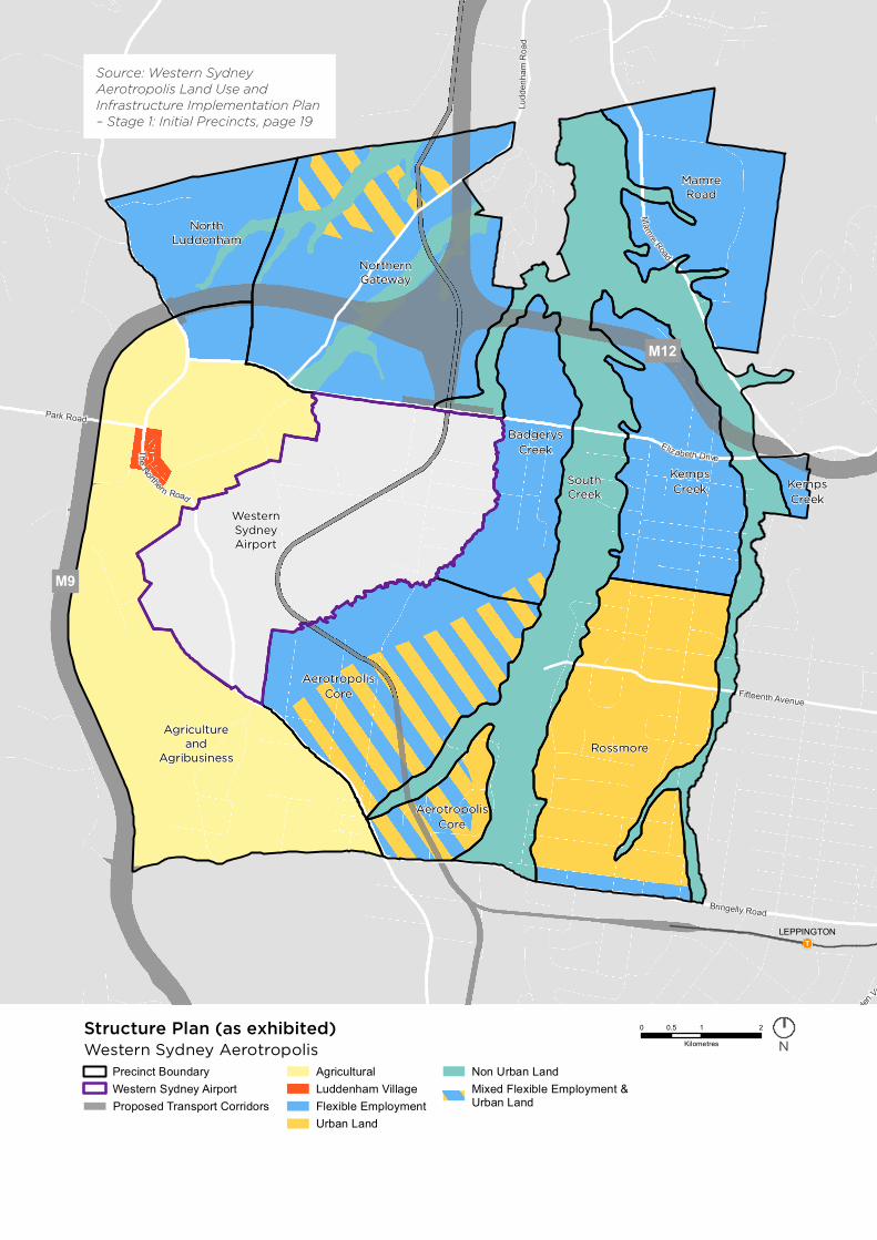
Submission analysis
Of those that responded by submission
61.5% were objections
32.7% had some comments
5.8% had some positive feedback
81% were from local residents
69% lived in South Creek – Wianamatta Precinct
60% raised issues about South Creek – Wianamatta Precinct
50% were concerned about impact on land value and zoning
The greatest concerns were
Land value as a result of proposed zonings
Precinct boundaries
Suitability of land and location for proposed zoning
Support shown for
Planning for sustainable operations of Western Sydney International (Nancy-Bird Walton) Airport
Planned number of jobs and homes
The vision for Aerotropolis
5What We Heard | Community Consultation Report
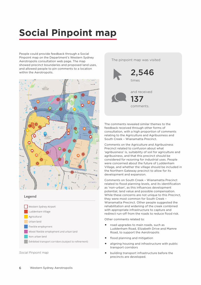
Social Pinpoint map
People could provide feedback through a Social Pinpoint map on the Department’s Western Sydney Aerotropolis consultation web page. The map showed precinct boundaries and proposed land uses, and allowed people to pin comments to a location within the Aerotropolis.
The pinpoint map was visited
2,546 times
and received
137 comments.
The comments revealed similar themes to the feedback received through other forms of consultation, with a high proportion of comments relating to the Agriculture and Agribusiness and South Creek – Wianamatta Precinct.
Comments on the Agriculture and Agribusiness Precinct related to confusion about what ‘agribusiness’ is, suitability of soil for agriculture and agribusiness, and that this precinct should be considered for rezoning for industrial uses. People were concerned about the future of Luddenham Village, and whether the village should be included in the Northern Gateway precinct to allow for its development and expansion.
Comments on South Creek – Wianamatta Precinct related to flood planning levels, and its identification as ‘non-urban’, as this influences development potential, land value and possible compensation. While these concerns are not unique to this Precinct, they were most common for South Creek – Wianamatta Precinct. Other people suggested the rehabilitation and widening of the creek combined with appropriate infrastructure to capture and redirect run-off from the roads to reduce flood risk.
Other comments related to:
• road upgrades to main roads, such as Luddenham Road, Elizabeth Drive and Mamre Road, to support the Aerotropolis
• flood planning and mitigation
• aligning housing and infrastructure with public transport corridors
• building transport infrastructure before the precincts are developed.
Social Pinpoint map
6 Western Sydney Aerotropolis
7What We Heard | Community Consultation Report

Key themes
South Creek – Wianamatta PrecinctSouth Creek – Wianamatta Precinct is the central green spine of the Aerotropolis. It will provide an important transition to surrounding development providing open space, amenity, biodiversity and where appropriate, subject to further investigations, some development. Most submissions related to South Creek raised issues of property acquisition, zoning, future use, land value and flooding.
See page 10
Agriculture and Agribusiness PrecinctThe establishment of a world leading Agriculture and Agribusiness Precinct will support existing agriculture enterprises, and enable new integrated and intensive production systems of value-added high-quality produce and pre-prepared consumer foods. This Precinct will champion sustainability, integrating food production with industry, energy, waste and water. Linkage to the freight and logistic operations of the new airport enables delivery from farm gate to international consumer plate within 24 hours. Some submissions supported the intention of the Precinct, others raised questions in relation to the mix of uses, existing uses, potential land use conflict and the future of Luddenham. The community also sought clarification regarding the agriport, its size, location, use and viability.
See page 15
8 Western Sydney Aerotropolis

Precinct boundaries and sequencingThe Stage 1 LUIIP identified nine precincts including the initial precincts of Aerotropolis Core, Northern Gateway and South Creek. Submissions sought to include particular areas into precincts through boundary amendments or the identification of additional precincts. Others requested certain areas, such as Badgerys Creek, be identified as an initial precinct to allow early planning and development.
See page 18
Airport impactsPlanning for the Aerotropolis capitalises on the once-in-a generation economic boom created by Western Sydney International (Nancy-Bird Walton) Airport while also recognising the operational impacts of a 24-hour/seven-day a week international airport and the need to ensure the long-term sustainable operation of the Airport. Submissions discussed the appropriate location of residential development, bird strike, impacts on water supply and safety.
See page 20Transport and accessThe Stage 1 LUIIP recognises known road and rail corridors. Submissions discussed the implication of land acquisition, realignment of corridors, greater north–south and east–west connections and aligning infrastructure provision with new development.
See page 22
Except for confidential submissions, all submissions are available on the Department of Planning, Industry and Environment’s website www.planning.nsw.gov.au/Plans-for-your-area/Priority-Growth-Areas-and-Precincts/Western-Sydney-Aerotropolis
9What We Heard | Community Consultation Report
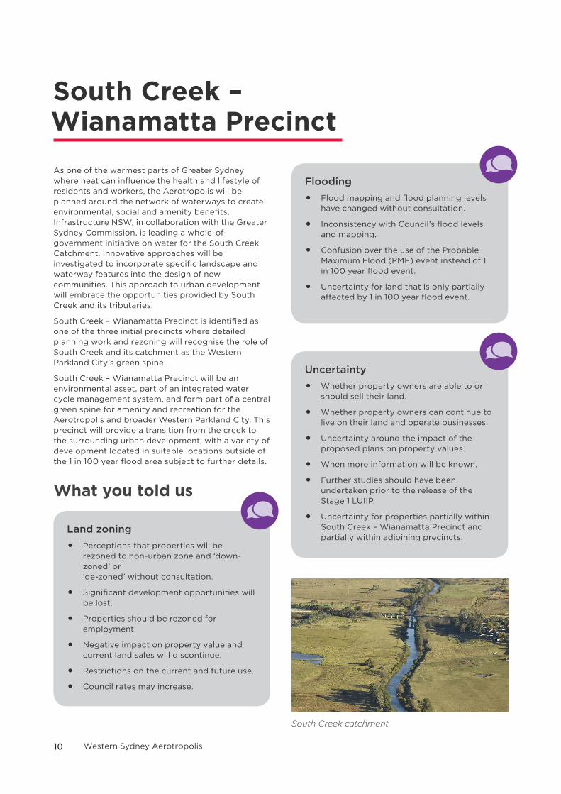
South Creek – Wianamatta Precinct As one of the warmest parts of Greater Sydney where heat can influence the health and lifestyle of residents and workers, the Aerotropolis will be planned around the network of waterways to create environmental, social and amenity benefits. Infrastructure NSW, in collaboration with the Greater Sydney Commission, is leading a whole-of-government initiative on water for the South Creek Catchment. Innovative approaches will be investigated to incorporate specific landscape and waterway features into the design of new communities. This approach to urban development will embrace the opportunities provided by South Creek and its tributaries.
South Creek – Wianamatta Precinct is identified as one of the three initial precincts where detailed planning work and rezoning will recognise the role of South Creek and its catchment as the Western Parkland City’s green spine.
South Creek – Wianamatta Precinct will be an environmental asset, part of an integrated water cycle management system, and form part of a central green spine for amenity and recreation for the Aerotropolis and broader Western Parkland City. This precinct will provide a transition from the creek to the surrounding urban development, with a variety of development located in suitable locations outside of the 1 in 100 year flood area subject to further details.
What you told us
Land zoning
• Perceptions that properties will be rezoned to non-urban zone and ‘down-zoned’ or ‘de-zoned’ without consultation.
• Significant development opportunities will be lost.
• Properties should be rezoned for employment.
• Negative impact on property value and current land sales will discontinue.
• Restrictions on the current and future use.
• Council rates may increase.
Flooding
• Flood mapping and flood planning levels have changed without consultation.
• Inconsistency with Council’s flood levels and mapping.
• Confusion over the use of the Probable Maximum Flood (PMF) event instead of 1 in 100 year flood event.
• Uncertainty for land that is only partially affected by 1 in 100 year flood event.
Uncertainty
• Whether property owners are able to or should sell their land.
• Whether property owners can continue to live on their land and operate businesses.
• Uncertainty around the impact of the proposed plans on property values.
• When more information will be known.
• Further studies should have been undertaken prior to the release of the Stage 1 LUIIP.
• Uncertainty for properties partially within South Creek – Wianamatta Precinct and partially within adjoining precincts.
South Creek catchment
10 Western Sydney Aerotropolis

Environmental
• Increased risk of bushfire.
• Potential economic value of the land for environmental offsets.
• Retention of rural character and ability to continue to live in area.
Property acquisition
• Unclear if or who will acquire properties and the value at which they will be acquired.
• Unclear about the processes of acquisition and timeframe.
• Fair compensation for property owners where land is not zoned for employment.
• Perception that the NSW Government will acquire land and obtain the uplift benefit through rezoning.
South Creek catchment
Clarification
Changes to zoning and land valuesThe Stage 1 LUIIP does not rezone any land. The precinct planning process will develop and implement planning mechanisms to rezone land for suitable land uses. Until then, any uses currently allowed under the LEP will remain permissible.
The final land use zones for the precinct are being determined through detailed precinct planning and could accommodate housing, businesses, shops, cafes and restaurants that will provide a transition from the surrounding urban development to the creek. We will consult with landowners before the final zones and land uses are finalised.
We understand the community’s concern about how a new zone could make existing land uses no longer permissible, impacting on residents and businesses. However, current planning legislation in NSW includes protection for uses that have been established with appropriate approvals. This protection is known as ‘existing use rights’ and allow uses that have been established with the appropriate approvals to continue to operate.
For example, a car and truck repair business that has a valid development consent to operate will be able to continue operating under ‘existing use rights’. Landowners should always seek advice from their local council, a planning consultant or lawyer if relying on existing use rights.
11What We Heard | Community Consultation Report
!T
M12
AirportCommercial
Precinct
PassengerTerminalPrecinct
Airport Freightand Logistics
Precinct
Western SydneyInternational
(Nancy-Bird Walton) Airport
LEPPINGTON
Fifteenth Avenue
Ludd
enha
m R
oad
Bringelly Road
Camde
n Valley Way
The No
rther
n Road
Elizabeth Drive
Mam
reRoad
Park Road
NorthLuddenham
AerotropolisCore
Agricultureand
Agribusiness
NorthernGateway
BadgerysCreek
Rossmore
MamreRoad
KempsCreek
South Creek - Wianamatta
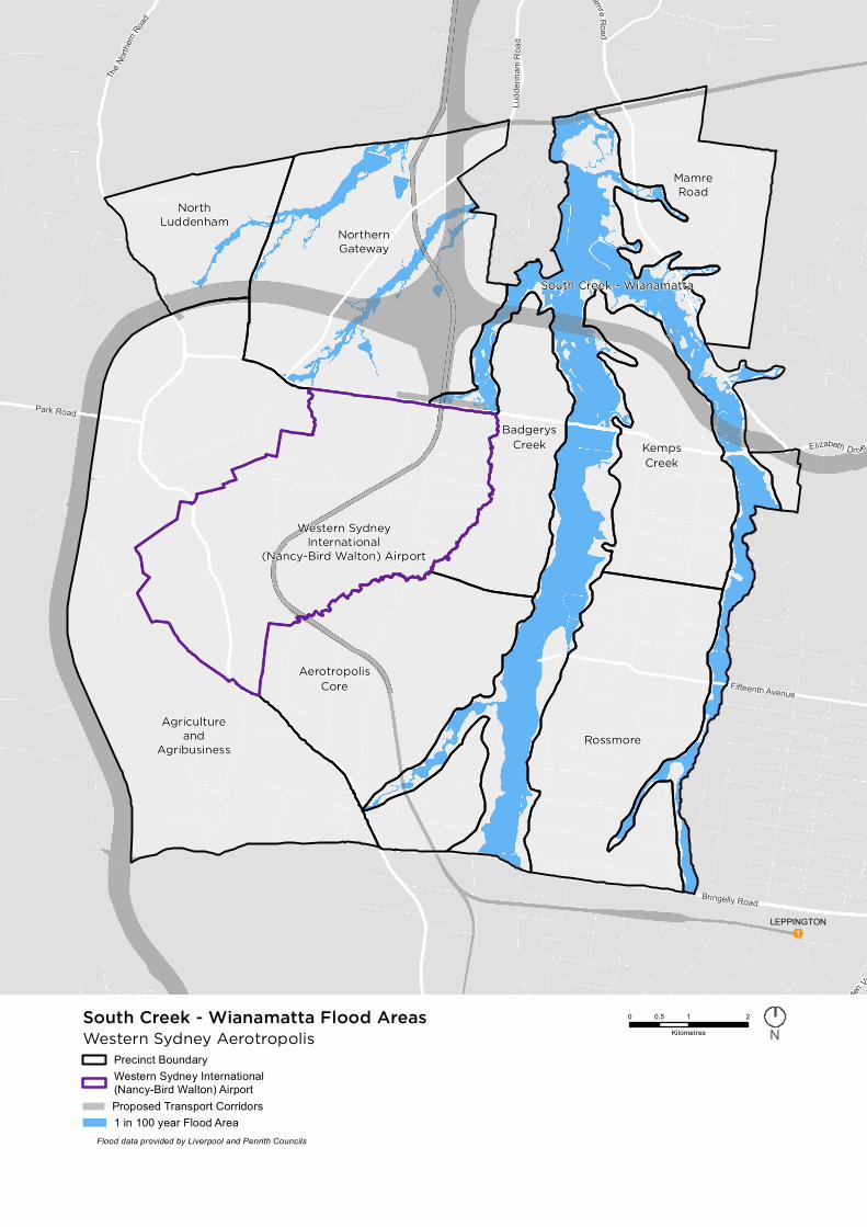
Precinct BoundaryWestern Sydney International(Nancy-Bird Walton) AirportProposed Transport Corridors1 in 100 year Flood Area
0 1 20.5
KilometresWestern Sydney AerotropolisSouth Creek - Wianamatta Flood Areas
N
Flood data provided by Liverpool and Penrith Councils

FloodingThe Probable Maximum Flood (PMF) line, combined with other environmental constraints such as existing water bodies and vegetation, was used to identify the boundary of South Creek – Wianamatta Precinct to meet broader government objectives for a central green spine and a landscape-led approach for the Western Parkland City.
The PMF line was not used for protection from flooding, but instead to ensure a high level of amenity could be achieved where water can be managed within the South Creek catchment. There has been no change to Council’s flood mapping.
As shown on the map on the previous page, the precinct primarily contains land within the 1 in 100 year flood line. Outside of the 1 in 100 year flood line, there are areas where some development may be able to occur, however this will be subject to further investigations as part of precinct planning.
No buildings should be located within the 1 in 100 year flood area. Outside the 1 in 100 year flood line, there may be opportunities for housing, businesses, shops, cafes, restaurants and parks. The location and type of development that can occur outside the 1 in 100 year flood line will depend on the nature of flooding and water management requirements and will be confirmed through further investigations and a risk assessment.
Definition of Probable Maximum Flood (PMF)The Probable Maximum Flood is the largest flood that could conceivably occur.
Definition of 1 in 100 year floodThe 1 in 100 year flood is a flood that has a 1% chance of occurring in any given year within a 100 year cycle.
Property acquisitionAs we are in the early stages of planning, we have not identified any properties for acquisition. Before this can occur, we will need to finalise the precinct plan for South Creek, which will identify land required for water management, roads, schools and open space. Until land is required, residents and businesses can continue to live/use their properties as they do now.
Property acquisition processIn NSW, State agencies, councils or other organisations (such as energy providers) can acquire property for a public purpose such as roads, schools, water management and open space. They may acquire the whole property, part of the property or temporary use of the property.
The acquiring agency will often consult with the community on proposed routes, locations and design to identify potential impacts. Community consultation informs the acquiring agency on what may be required to minimise community impact, including changes to design. When a preferred design is chosen, the acquiring agency identifies which properties need to be acquired.
Property value is determined by a qualified and independent valuer who calculates current market value by considering factors such as the property size, location, quality of improvements, recent sales in the area, and pest and building inspection reports. The value of the property is always assessed based on its ‘highest and best use’, as though it is unaffected by the project proposal.
The NSW Government is taking an integrated approach to land acquisition, in particular, ensuring better coordination between agencies in the Aerotropolis and Western City where there are many different projects with property impacts. The NSW Government has also introduced a series of reforms designed to make the process fairer, more transparent and with a renewed focus on the needs of the property owner.
Further information is available from the NSW Government’s Centre for Property Acquisition via https://www.propertyacquisition.nsw.gov.au
13What We Heard | Community Consultation Report

Our commitment• We are working with Infrastructure NSW
to implement the recommendations of its investigations into the design of the new communities in the Aerotropolis.
• We will not apply the ‘Non Urban’ zone to any land in South Creek – Wianamatta Precinct. We are identifying appropriate zones for the precinct following the completion of investigations being undertaken by several Government agencies, including Sydney Water and Infrastructure NSW, and through detailed precinct planning.
• We are refining the boundary of the precinct through the detailed precinct planning process and the work being undertaken by NSW Government agencies.
• We are working with NSW Government agencies, including Infrastructure NSW and Sydney Water to identify appropriate land uses within the South Creek corridor, including in the floodplain.
• Where properties are required for public infrastructure, they will be acquired at market value. We are working with the Centre for Property Acquisition NSW to ensure a clear process for any properties identified for acquisition and provide adequate information to all affected property owners.
• The Partnership will continue to engage with the community as we refine the plans for South Creek – Wianamatta Precinct.
14 Western Sydney Aerotropolis
Agriculture and Agribusiness Precinct
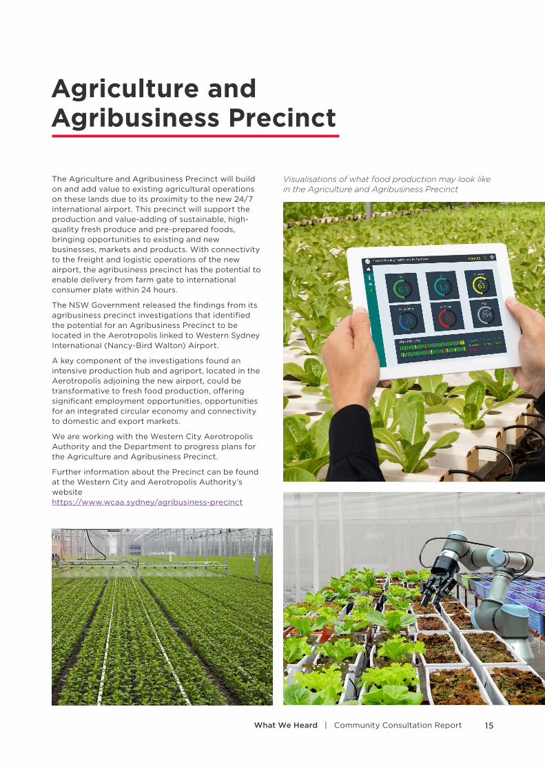
The Agriculture and Agribusiness Precinct will build on and add value to existing agricultural operations on these lands due to its proximity to the new 24/7 international airport. This precinct will support the production and value-adding of sustainable, high-quality fresh produce and pre-prepared foods, bringing opportunities to existing and new businesses, markets and products. With connectivity to the freight and logistic operations of the new airport, the agribusiness precinct has the potential to enable delivery from farm gate to international consumer plate within 24 hours.
The NSW Government released the findings from its agribusiness precinct investigations that identified the potential for an Agribusiness Precinct to be located in the Aerotropolis linked to Western Sydney International (Nancy-Bird Walton) Airport.
A key component of the investigations found an intensive production hub and agriport, located in the Aerotropolis adjoining the new airport, could be transformative to fresh food production, offering significant employment opportunities, opportunities for an integrated circular economy and connectivity to domestic and export markets.
We are working with the Western City Aerotropolis Authority and the Department to progress plans for the Agriculture and Agribusiness Precinct.
Further information about the Precinct can be found at the Western City and Aerotropolis Authority’s website https://www.wcaa.sydney/agribusiness-precinct
Visualisations of what food production may look like in the Agriculture and Agribusiness Precinct
15What We Heard | Community Consultation Report
What you told us
Suitability of land
• Some land within the precinct was considered unsuitable for agricultural purposes.
• Concerns over soil attributes, water quality and quantity and the proximity to the Airport.
• Concerns with land use conflicts such as health, noise, height, reflectivity, 24/7 operations and bird attraction.
• People questioned the impacts of industrial style agribusiness development on the quality of the rural and residential surroundings.
Precinct boundary
• Submissions suggested changes to the southern, western and northern precinct boundary due to existing land uses or additional opportunities.
• Submissions noted the importance of the land west of the boundary.
Land zoning
• Changes to zoning and broadening of permitted land uses for residential, business and industrial purposes were suggested.
• Concerns around the impact on property values.
Uncertainty
• It was unclear what the precinct vision is.
• People were concerned that they needed to relocate or need to stop existing permitted uses.
• People wanted to know about the role and future of Luddenham Village.
• It was unclear what the agriport is, where it will be located and its size.
• Timeframe for development unclear.
Property acquisition
• Whether agricultural land will be acquired by the government.
Transport
• The Outer Sydney Orbital corridor should be moved west, connections improved, and the Agriculture and Agribusiness Precinct expanded west.
Heritage
• The heritage school should be preserved.
16 Western Sydney Aerotropolis
Clarification
AgribusinessAgribusiness can be defined as businesses associated with the production, processing, marketing and distribution of agricultural products, especially at a large and integrated scale. This could include biotechnology research and development, organisations involved in smart high-tech farming practices, data centres to enable traceability and protect food providence and authenticity, advanced manufacturing and logistics hubs, technical services for robotics and farm machinery, food processing, export enabling infrastructure, central fresh food markets that support wholesale marketing and retail sales.
AgriportAn Agriport is a high-tech food production facility that enables industry collaboration at scale to intensively and sustainably produce fresh value-added high-quality produce and pre-prepared food.
Existing usesWe understand and acknowledge that there is a mixture of businesses operating in the precinct. Under ‘existing use rights’ in the Environmental Planning and Assessment Act 1979, these land uses and businesses can continue to operate despite any future changes that may be made to the land use zone, provided the business was established with appropriate approvals. Landowners should always seek advice from council, a planning consultant or lawyer if they intend to rely on existing use rights.
Our Commitment• We are working with the Western City &
Aerotropolis Authority and the Department as it continues work on developing an implementation plan for the Agriculture and Agribusiness precinct.
• We are examining the precinct boundary and considering the request for the creation of new precincts or the inclusion of some areas in adjoining precincts.
• We are liaising with Transport for NSW as it reviews and assesses all submissions on the Outer Sydney Orbital alignment.
• We are analysing the existing zoning arrangements and identifying amendments to allow for other permitted land uses to support the development of the precinct.
• We are analysing the existing agricultural development planning approval pathways and built form controls and identifying opportunities to streamline planning approvals and support the development of the Agriculture and Agribusiness precinct.
• We are identifying and protecting significant cultural and heritage items and landscape features from inappropriate development.
• If required, we will identify any sites selected for government land acquisition, confirm the process for any properties identified for acquisition and provide information about property acquisitions to relevant landowners.
• We are working with stakeholders and the community to identify the future opportunities, role and function of Luddenham Village.
• We will continue to work with the Department of Infrastructure, Transport, Cities and Regional Development, and NSW government agencies to ensure any development within the precinct does not compromise the operations of the airport and that planning work is consistent with the relevant provisions of the National Airports Safeguarding Framework, and is appropriate in that location.
17What We Heard | Community Consultation Report
Precinct boundaries and sequencing
What you told us
South Creek
• Use 1 in 100 year flood level instead of Probable Maximum Flood line for boundary.
• Request to allow owners to choose a precinct where their property straddles a boundary.
Agriculture and Agribusiness
• Requests to be included in the Aerotropolis Core, Southern Gateway or Northern Gateway.
• Should be an initial precinct.
• Timeframe of rezoning.
• Expand boundary to the west of the Outer Sydney Orbital.
Aerotropolis Core
• Support to be an initial precinct.
Northern Gateway
• Support to be an initial precinct.
• Mapping should be clearer around Cosgrove Creek.
• Corridor alignment should be delayed until precinct planning completed.
Badgerys Creek
• Should be an initial precinct.
• Unclear where the boundaries of the precinct are.
Mamre Road
• Should be an initial precinct.
• Rezoning to employment lands should be expedited.
• Could be retained in the Western Sydney Employment Area.
Rossmore
• Request to prioritise rezoning to create residential land for workers of the Aerotropolis.
• Support for expedited delivery of infrastructure.
Kemps Creek
• Request to allow owners to nominate a precinct where straddling boundary.
• Request to exclude part of the precinct from the Aerotropolis boundary.
18 Western Sydney Aerotropolis

North Luddenham
• Should be an initial precinct.
• Request to be part of the Northern Gateway.
Aerotropolis Wide
• Rezoning and development should occur before the airport operates.
• Opportunities for development that are out of sequence with stages in the Stage 1 LUIIP are generally supported.
• Clarification needed on precinct boundaries.
• The staged release of precincts is supported.
• Existing established agricultural operations should be allowed to continue across the Aerotropolis.
Outside
• Include Horsley Park and Mt Vernon in the overall boundary as these are well connected, and areas in Wollondilly and land south of Greendale Road.
• St Marys Station Precinct should be redeveloped sooner than later.
• Land adjoining Sydney Metro Greater West to be an initial precinct.
• Flexible employment for land at corner of Mamre Road and Elizabeth Drive.
• Request urban land to the west of North Luddenham precinct.
Our commitmentWe are assessing all requests for sequencing and boundaries amendments as we prepare the final LUIIP. We are reviewing:
• Land requirements for water and green infrastructure (South Creek)
• Whether current land ownership patterns are a possible impediment to redevelopment
• Potential noise impacts and the suitable location of noise sensitive land use, recognising the need to protect communities from the 24-hour/seven-day a week operation of the airport
• The potential for land use conflict between future proposed land uses
• Land suitability, including topography and capability for proposed future land uses
• Future demand and supply for particular land uses to ensure that sufficient land is identified for the range of uses necessary to support the Aerotropolis and the Western Parkland City
• Proximity of sites to the freight and logistics of Western Sydney International (Nancy-Bird Walton) Airport to realise the value of this opportunity
• The outcomes of the Department’s feasibility study
• The LUIIP in the context of the state and regional planning framework
• Vision and policy drivers for the development of the Aerotropolis as identified in the Stage 1 LUIIP
• Capacity of utility/servicing including water, wastewater, stormwater, electricity, transport, green infrastructure and delivery timeframes.
We are reviewing the framework for out of sequence development proposals that are inconsistent with the timing in the Stage 1 LUIIP.
19What We Heard | Community Consultation Report
Airport impacts
What you told us
Airport
• Support for an airport in Western Sydney.
• Concern that the airport will operate curfew free.
• Perception that the Environmental Impact Statement (EIS) for Airport was approved without consultation.
• Perceptions that ground-based noise impacts were not considered.
• Concerns with the flight paths, noise and obstacle limitation surface heights.
• Concerns with airport being close to Warragamba Dam.
Residential Development
• Need to increase distance of residential development from the airport.
• Should consider use of all noise metrics in addition to ANEF/ANEC contours.
National Airports Safeguarding Framework
• Need to avoid bird attracting uses within South Creek.
• Need to ensure any development within and around the Aerotropolis is consistent with the National Airports Safeguarding Framework.
Clarification
Definition of Australian Noise Exposure concept (ANEC)Anticipated forecasts of future noise exposure patterns based on indicative flight paths around an airport that constitute the contours.
Definition of Australian Noise Exposure Forecast (ANEF)Approved forecasts of future noise exposure patterns around an airport that constitute the contours on which land use planning authorities base their controls.
20 Western Sydney Aerotropolis

Western Sydney International (Nancy-Bird Walton) Airport The Australian Government is investing up to $5.3 billion to deliver Western Sydney International (Nancy-Bird Walton) Airport. Western Sydney Airport, an Australian-owned company, was established to build and operate the airport.
The Australian Government conducted an environmental impact assessment on the airport project from January 2015 to September 2016. Consultation was undertaken as part of the assessment, with the community invited to attend information sessions and make submissions on the draft Environmental Impact Statement.
The draft EIS was on public exhibition from 19 October to 18 December 2015 along with the draft Airport Plan. Construction commenced in September 2018, with the airport set to open in 2026.
The process of determining flight paths is now underway and being led by the Department of Infrastructure, Transport, Cities and Regional Development. Community consultation will be undertaken as part of the flight path design process.
Land use planning is the best way to reduce the impact of aircraft noise on the communities around the airport. Long-standing planning controls have largely protected the area around the airport site from encroaching residential development.
In May 2018, the Australian Government Minister for Urban Infrastructure and Cities and the former NSW Minister for Planning confirmed both Governments’ commitment to the long established provisions that new residences are prevented from being developed where the ANEF exceeds 20 (previously 25 ANEF).
Any questions regarding the approval process and flight path development should be directed to the Department of Infrastructure, Transport, Cities and Regional Development on (02) 6274 7111. Any questions about the construction and operation of the airport should be directed to Western Sydney Airport.
Our Commitment • We will continue to refer airport-related
questions to Western Sydney Airport and the Department of Infrastructure, Transport, Cities and Regional Development depending on the nature of the question.
• We are working with stakeholders to ensure any development within and around the Aerotropolis does not compromise the operations of the airport and is appropriate in that location.
21What We Heard | Community Consultation Report
Transport and access
Roads
What you told us
SupportMost submissions relating to road infrastructure were in support of the proposed roads for the Aerotropolis. Some suggested alternate alignments, upgrades or extensions, or raised concerns regarding the need to provide local road connections.
• The Outer Sydney Orbital (M9) corridor should be moved west, connections improved, and the Agriculture and Agribusiness Precinct expanded west.
• The proposed M12 motorway corridor, connecting Western Sydney International (Nancy-Bird Walton) Airport to the Sydney motorway network, should be realigned, based on technical studies and economic analysis.
• Greater clarity is required regarding connections between the M12 Motorway and surrounding employment lands to enable precinct planning. A grade separated connection between the M12 Motorway and Elizabeth Drive is critical to connect the Western City and the Airport.
• The upgrade of Elizabeth Drive should be an early infrastructure commitment to support the Northern Gateway and Airport.
• Fifteenth Avenue should be upgraded and extended, as an early prioritised link to the Aerotropolis Core.
• Critical ‘last mile’ local road connections between the Airport and established employment and residential land must be provided.
• Roads need to be upgraded, including key connections between the Airport and both the M9 and M12 by 2026.
• Opportunities exist for upgrades to Mamre Road due to existing and future motorway connections.
• In the longer term, a bus-only tunnel and extension of Lawson Road to a collector road would provide the much-needed grid network for this area.
• The regional road network should be identified in the final LUIIP and precinct plans, including ring roads, and concept designs for land surrounding road corridors.
• Realignment of The Northern Road would provide more frontage and improve access.
ObjectionsObjections related to the concern that the proposed road infrastructure would impact on existing businesses in the Aerotropolis. There were also perceived inconsistencies in the timing of delivery of preserved road corridors between Transport for NSW’s strategic planning documents and the Stage 1 LUIIP.
22 Western Sydney Aerotropolis

Rail corridors and station locations
What you told us
Some submissions requested changes to corridor alignments, others requested stations on their sites, and others noted that public transport services were essential.
• Support for the planned Sydney Metro Greater West and a connection to Leppington.
• The Sydney Metro Greater West link needs to be operational from the start of operation of the Airport.
• A fast rail connection needs to be constructed to support the new Airport.
• Transport alignments should be moved, including suggestions that the planned rail line should be realigned to the east, or avoid individual landowner’s sites, or align through other preferred sites.
• Planning for a new interchange at St Marys should start as soon as possible to ensure residents have clarity about potential acquisition and land use.
• Request for a station at Northern Gateway and at Luddenham.
• Commercial landholders in the Aerotropolis requested realignment of the proposed Sydney Metro Greater West through their sites or stations to be located on their sites. They offered to help construct stations or to enter into voluntary planning agreements to help fund infrastructure.
• A landholder that owns land in St Marys, Prairiewood and Yennora suggested rail links from the Aerotropolis to St Marys via the Western Sydney International (Nancy-Bird Walton) Airport, with a transport interchange at St Marys, and later a link to Rouse Hill via Schofields; an East–West rail link between the Airport and Parramatta via Prairiewood; and a dedicated freight rail between the M9 and Southern Sydney Freight Line, servicing Yennora.
Our commitment• We are working with all relevant
authorities, including Transport for NSW and councils, to plan for and fund road and rail infrastructure corridors and alignments.
• We will identify the primary road network once station locations and centres have been determined in the final LUIIP with finer grain road network identified as part of detailed precinct planning.
• The refinement of rail corridors and identification of station locations will be conducted in collaboration with Sydney Metro.
• We will collaborate with Transport for NSW to undertake detailed integrated transport and land use planning for centres.
Clarification
Proposed Road and Rail ProjectsThe Australian and NSW Governments have announced road infrastructure projects to service the airport and improve connectivity.
Projects include the M12 Motorway, to provide a connection between the M7 Motorway and the new Western Sydney International (Nancy-Bird Walton) Airport , and the proposed Outer Sydney Orbital corridor. Community consultation on the Outer Sydney Orbital was held in the first half of 2018. Transport for NSW is continuing to review and assess all submissions, to refine the alignment and ensure the best possible outcomes for the people of Western Sydney.
The final alignment of the rail corridors through the Aerotropolis and to the airport are being considered by Sydney Metro, Transport for NSW, and the NSW and Australian Governments with the final business case, confirming alignment and station locations, expected in early 2020.
23What We Heard | Community Consultation Report
Agency, industry and site specific submissions
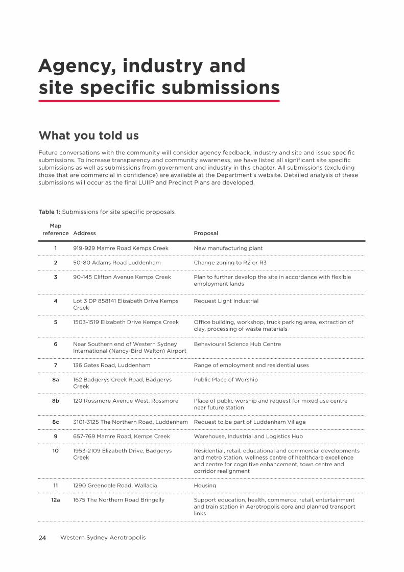
What you told usFuture conversations with the community will consider agency feedback, industry and site and issue specific submissions. To increase transparency and community awareness, we have listed all significant site specific submissions as well as submissions from government and industry in this chapter. All submissions (excluding those that are commercial in confidence) are available at the Department’s website. Detailed analysis of these submissions will occur as the final LUIIP and Precinct Plans are developed.
Table 1: Submissions for site specific proposals
Map reference Address Proposal
1 919-929 Mamre Road Kemps Creek New manufacturing plant
2 50-80 Adams Road Luddenham Change zoning to R2 or R3
3 90-145 Clifton Avenue Kemps Creek Plan to further develop the site in accordance with flexible employment lands
4 Lot 3 DP 858141 Elizabeth Drive Kemps Creek
Request Light Industrial
5 1503-1519 Elizabeth Drive Kemps Creek Office building, workshop, truck parking area, extraction of clay, processing of waste materials
6 Near Southern end of Western Sydney International (Nancy-Bird Walton) Airport
Behavioural Science Hub Centre
7 136 Gates Road, Luddenham Range of employment and residential uses
8a 162 Badgerys Creek Road, Badgerys Creek
Public Place of Worship
8b 120 Rossmore Avenue West, Rossmore Place of public worship and request for mixed use centre near future station
8c 3101-3125 The Northern Road, Luddenham Request to be part of Luddenham Village
9 657-769 Mamre Road, Kemps Creek Warehouse, Industrial and Logistics Hub
10 1953-2109 Elizabeth Drive, Badgerys Creek
Residential, retail, educational and commercial developments and metro station, wellness centre of healthcare excellence and centre for cognitive enhancement, town centre and corridor realignment
11 1290 Greendale Road, Wallacia Housing
12a 1675 The Northern Road Bringelly Support education, health, commerce, retail, entertainment and train station in Aerotropolis core and planned transport links
24 Western Sydney Aerotropolis
Map reference Address Proposal
12b 225-245 Badgerys Creek Road, Bringelly Support education, health, commerce, retail, entertainment and train station in Aerotropolis core
13 1793-1951 Elizabeth Drive Badgerys Creek and 885A Mamre Road, Kemps Creek
Hotel, retail, bulky goods, business park, industry park
14 475 Badgerys Creek Road, Badgerys Creek
Support for mixed use development and transit corridor through site
15 203 Greendale Road, Bringelly Build a world trade centre with offices, retail and residential development, request rail station
16 Lot 90 and 91 DP 1101411 Elizabeth Drive, Kemps Creek
Upgrade and expand landfill and recycling centre
17 235 Martin Road, Badgerys Creek Advanced manufacturing hub
18 Various properties in Luddenham Request urban land
19 327-329 Luddenham Road, Orchard Hills; and 443-457 Luddenham Road, Luddenham
Request mixed flexible employment and urban land and corridor realignment
20 221-227 Luddenham Road, Orchard Hills Metro station, mixed flexible employment, urban land, housing, hospital, school and an urban farm
21 2207-2230 Elizabeth Drive, Luddenham; 775 Luddenham Road, Luddenham; 777-819 Luddenham Road, Luddenham; 765 Luddenham Road, Luddenham
Develop the site for large format logistics, warehousing and employment lands
22 435 Willowdene Avenue, Luddenham; 527 Greendale Road, Greendale; and 711 Greendale Road, Greendale
Fresh food precinct, inclusive of an agri-port, high value production, processing and packaging technology
23 Within and adjacent to the agriculture and agribusiness precinct
Fresh food precinct, inclusive of an agri-port, high value production, processing and packaging technology
24 3019-3035 The Northern Road, Luddenham
Local centre retailing, unique food precinct, farmers markets
25 565-609 Luddenham Road, Luddenham Increase dwellings from 3,400 to 30,000 plus, remove GFA cap, increase retail from 30,000m2 to 130,000m2
26 Various properties in Luddenham Request to be flexible employment
27 Lot 5 in DP860456; Lot 741 in DP810111; Lots 1 and 2 in DP587135; and Lots 7, 9 and 10 in DP812284.
Confidential
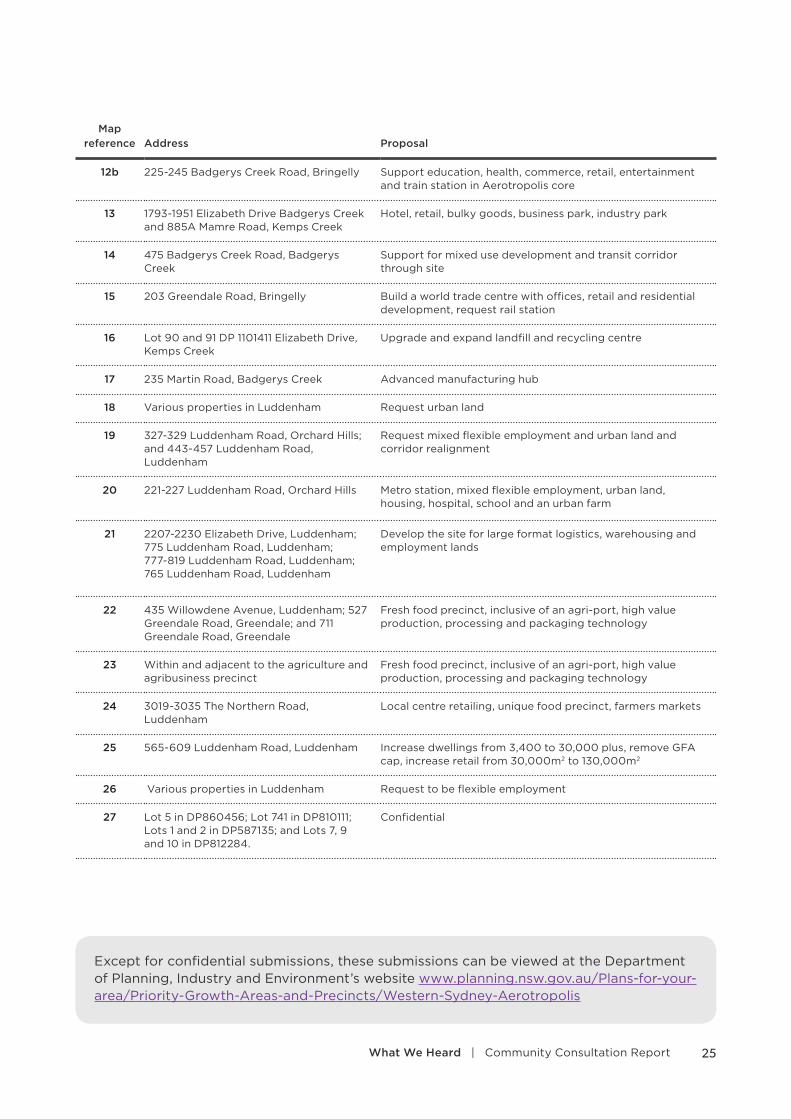
Except for confidential submissions, these submissions can be viewed at the Department of Planning, Industry and Environment’s website www.planning.nsw.gov.au/Plans-for-your-area/Priority-Growth-Areas-and-Precincts/Western-Sydney-Aerotropolis
25What We Heard | Community Consultation Report

!T
Western SydneyInternational (Nancy-Bird
Walton) Airport
NorthLuddenham
AerotropolisCore
Agricultureand
Agribusiness
NorthernGateway
BadgerysCreek
Rossmore
Mamre Road
Kemps Creek
SouthCreek
- Wianamatta
DefenceEstablishmentOrchard Hills
The Northern Road
Elizabeth Drive
Mamre Road
Camden Valle
yW
ay
Park Road
Mulgoa Roa d
1
2
3
45
7
9
10
11
15
16
19
19
20
21
22
22
24
6
12b12a
23
25
27
27
17
18 13
13
25
8a
26
14
8b
8c
Precinct BoundaryWestern Sydney International(Nancy-Bird Walton) Airport PrecinctNational Parks and Nature ReservesEnvironmental Conservation
!T Railway StationRailwayWaterwaysDevelopment Proposal IndicativeLocationDevelopment Proposal Lots
0 1 20.5
KilometresWestern Sydney AerotropolisDevelopment Proposals and Concepts
N
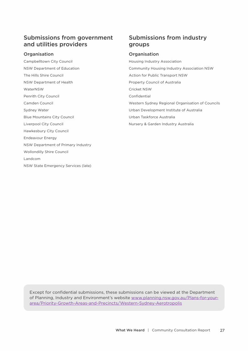
Submissions from government and utilities providers
OrganisationCampbelltown City Council
NSW Department of Education
The Hills Shire Council
NSW Department of Health
WaterNSW
Penrith City Council
Camden Council
Sydney Water
Blue Mountains City Council
Liverpool City Council
Hawkesbury City Council
Endeavour Energy
NSW Department of Primary Industry
Wollondilly Shire Council
Landcom
NSW State Emergency Services (late)
Submissions from industry groups
OrganisationHousing Industry Association
Community Housing Industry Association NSW
Action for Public Transport NSW
Property Council of Australia
Cricket NSW
Confidential
Western Sydney Regional Organisation of Councils
Urban Development Institute of Australia
Urban Taskforce Australia
Nursery & Garden Industry Australia
Except for confidential submissions, these submissions can be viewed at the Department of Planning, Industry and Environment’s website www.planning.nsw.gov.au/Plans-for-your-area/Priority-Growth-Areas-and-Precincts/Western-Sydney-Aerotropolis
27What We Heard | Community Consultation Report

The way forward
The Planning Partnership will respond in detail to the issues raised in the submissions and develop the final LUIIP and associated precinct plans over the next few months.
Final LUIIP The Planning Partnership is now progressing investigations and collaborating with stakeholders in preparation of a final LUIIP.
The final LUIIP will provide a greater level of detail, drawing on the work being undertaken across government.
The final LUIIP will identify:
• precinct boundaries
• precinct staging
• the vision and strategic objectives of each precinct
• road hierarchy
• biodiversity conservation areas
• Blue-Green Framework identified through Infrastructure NSW
• recommendations for the Agriculture and Agribusiness Precinct as identified by Western City & Aerotropolis Authority
Statutory planning framework A proposed State Environmental Planning Policy was outlined in the Stage 1 LUIIP. We are currently developing the statutory framework for rezoning land.
Precinct PlanningThe Aerotropolis Core, the Northern Gateway and South Creek have been identified as initial precincts. The Planning Partnership will prepare the draft precinct plans that will inform the rezoning of land.
These plans will include indicative layouts that identify the locations for land uses.
The draft plans will be exhibited and input from the community will be sought. After consideration of submissions, the draft precinct plans will be finalised and the land rezoned.
Planning for Infrastructure
Growth Infrastructure Compact (GIC) A Growth Infrastructure Compact (GIC) for the Western Sydney Aerotropolis is being prepared by the Greater Sydney Commission to assist in coordinating planning and delivery of new jobs and housing supply and ensure that the required infrastructure is delivered as it is needed. The precinct plans will take into consideration the GIC’s outcomes.
Special Infrastructure Contributions Plan (SIC)A SIC will be developed to fund and deliver regional infrastructure. The infrastructure schedule and SIC rate will be prepared and exhibited by the Department. Specific SIC rates may be developed for each precinct and may be refined with more detailed planning. The likely rates of these plans will be at least the equivalent of SIC rates in adjoining growth areas.
Local Infrastructure Contributions PlansLocal infrastructure upgrades will also need to be undertaken. This would include works such as local road and intersection upgrades, upgrades to local drainage infrastructure and provision of local social infrastructure, such as community facilities.
As part of precinct planning, the Planning Partnership will work with councils to identify local infrastructure that will be required for the respective precinct and prepare new local contributions plans.
28 Western Sydney Aerotropolis
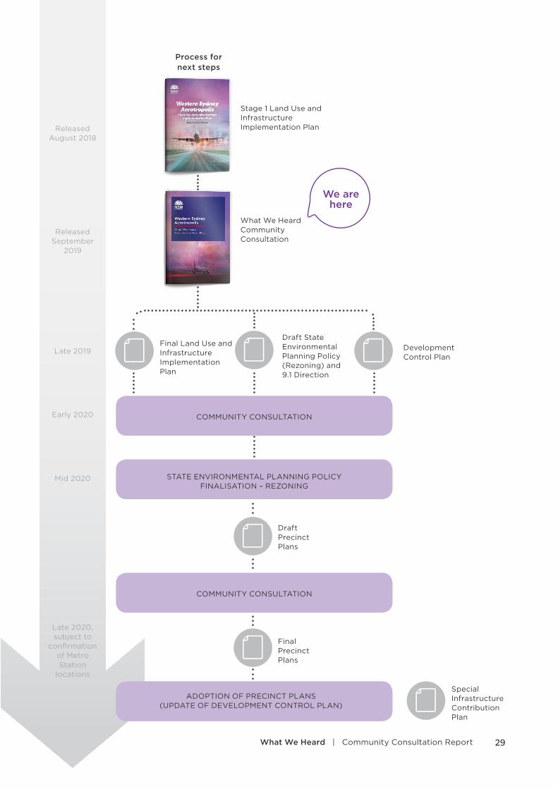
Process for next steps
Stage 1 Land Use and Infrastructure Implementation Plan
We are here
Early 2020
Late 2019
Mid 2020
Late 2020, subject to
confirmation of Metro Station
locations
What We Heard Community Consultation
Development Control Plan
Draft Precinct Plans
Final Precinct Plans
Final Land Use and Infrastructure Implementation Plan
Special Infrastructure Contribution Plan
Draft State Environmental Planning Policy (Rezoning) and 9.1 Direction
COMMUNITY CONSULTATION
COMMUNITY CONSULTATION
ADOPTION OF PRECINCT PLANS (UPDATE OF DEVELOPMENT CONTROL PLAN)
STATE ENVIRONMENTAL PLANNING POLICY FINALISATION – REZONING
Released August 2018
Released September
2019
29What We Heard | Community Consultation Report
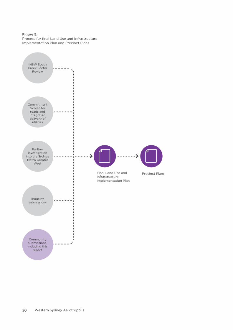
Figure 5: Process for final Land Use and Infrastructure Implementation Plan and Precinct Plans
INSW South Creek Sector
Review
Commitment to plan for roads and integrated delivery of
utilities
Further investigation
into the Sydney Metro Greater
West
Industry submissions
Community submissions, including this
report
Final Land Use and Infrastructure Implementation Plan
Precinct Plans
30 Western Sydney Aerotropolis
How to participateThe Planning Partnership is committed to engaging with the community and industry as we develop plans for the future of the Western Sydney Aerotropolis.
If you have any questions, you can get in touch with the Planning Partnership by:
Phone
1300 305 695
31What We Heard | Community Consultation Report


![State Environmental Planning Policy (Western Sydney ...Page 6 Published LW 11 September 2020 (2020 No 545) State Environmental Planning Policy (Western Sydney Aerotropolis) 2020 [NSW]](https://img.pdfslide.net/doc/110x75/6133e1badfd10f4dd73b600c/state-environmental-planning-policy-western-sydney-page-6-published-lw-11-september.jpg)