Embed Size (px)
Citation preview
© CRC LEME 2003 Western Volcanic Plains Page 1
WESTERN VOLCANIC PLAINS, VICTORIA
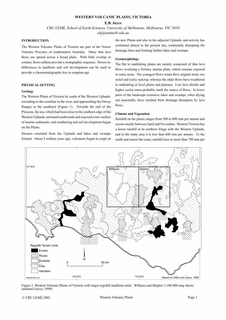
Figure 1. Western Volcanic Plains of Victoria with major regolith landform units. Willaura and Skipton 1:100 000 map sheets outlined (Joyce, 1999)
E.B. JoyceCRC LEME, School of Earth Sciences, University of Melbourne, Melbourne, VIC 3010
INTRODUCTION
The Western Volcanic Plains of Victoria are part of the Newer Volcanic Province of southeastern Australia. Many thin lava flows are spread across a broad plain. With little overlap or contact, flows seldom provide a stratigraphic sequence. However, differences in landform and soil development can be used to provide a chronostratigraphic key to eruption age.
PHYSICAL SETTING
GeologyThe Western Plains of Victoria lie south of the Western Uplands, extending to the coastline in the west, and approaching the Otway Ranges in the southeast (Figure 1). Towards the end of the Pliocene, the sea, which had been close to the southern edge of the Western Uplands, retreated southwards and exposed a new surface of marine sediments, and weathering and soil development began on the Plains.
Streams extended from the Uplands and lakes and swamps formed. About 5 million years ago, volcanoes began to erupt on
the new Plains and also in the adjacent Uplands, and activity has continued almost to the present day, continually disrupting the drainage lines and forming further lakes and swamps.
GeomorphologyThe flat to undulating plains are mainly composed of thin lava flows overlying a Tertiary marine plain, which remains exposed in some areas. The youngest flows retain their original stony rise relief and rocky outcrop, whereas the older flows have weathered to undulating or level plains and plateaus. Low lava shields and higher scoria cones probably mark the source of flows. In lower parts of the landscape extensive lakes and swamps, often drying out seasonally, have resulted from drainage disruption by lava flows.
Climate and VegetationRainfall on the plains ranges from 500 to 800 mm per annum and occurs mostly between April and November. Western Victoria has a lower rainfall at its northern fringe with the Western Uplands, and in the study area it is less than 600 mm per annum. To the south and nearer the coast, rainfall rises to more than 700 mm per
© CRC LEME 2003 Western Volcanic Plains Page 2
annum, encouraging more plant growth.
January and February are the hottest months, with temperatures over 25ºC. July is coldest, with a minimum of 5ºC. Cold and wet southwesterly winds are common in winter and provide problems for farmers on the treeless plains. Hot dry northerlies in summer, occasional droughts, and fierce grass fires complete the climate picture.
Much of the area is grassland, now mainly introduced species, with only occasional planted windbreaks of trees along fence lines. Original pre-contact vegetation was also largely grassland, perhaps maintained by aboriginal burning. The older, deeply weathered lava flows supported dry sclerophyll forest, savannah woodland and minor grassland when European settlers arrived. The youngest flows had woodlands of manna gum and blackwood on the stony rise ridges where rock outcropped, and wet tussock grasslands where swamps had developed in depressions.
REGOLITH–LANDFORM RELATIONSHIPS
An initial basaltic volcanic landscape changes with time as a result of weathering and soil formation, the development of drainage systems, and related alterations to the original volcanic landforms.
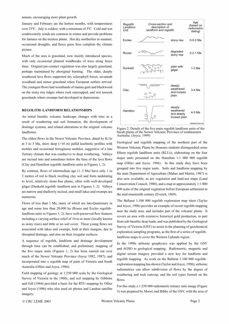
The oldest flows in the Newer Volcanic Province, dated by K/Ar at 3 to 5 Ma, show deep (>10 m) pallid kaolinitic profiles with mottles and occasional ferruginous nodules, suggestive of a late Tertiary climate that was conducive to deep weathering. Valleys are incised into and sometimes below the base of the lava flows (Clay and Hamilton regolith–landform units in Figures 1, 2).
By contrast, flows of intermediate age (1–3 Ma) have only 1 to 2 metres of red to black swelling clay soil and form undulating to level, relatively stone-free plains, often with well-developed gilgai (Dunkeld regolith–landform unit in Figures 1, 2). Valleys are narrow and shallowly incised, and small lakes and swamps are numerous.
Flows of less than 1 Ma, many of which are late-Quaternary in age and some less than 20,000 ka (Rouse and Eccles regolith–landform units in Figures 1, 2), have well-preserved flow features including a varying surface relief of 10 m or more (locally known as stony rises) and little or no soil cover. These young flows are associated with lakes and swamps, both at their margins, due to disrupted drainage, and also on their irregular surfaces.
A sequence of regolith, landform and drainage development through time can be established, and preliminary mapping of the five major units (Figures 1, 2) has been carried out over much of the Newer Volcanic Province (Joyce 1982, 1987), and incorporated into a regolith map of parts of Victoria and South Australia (Ollier and Joyce, 1986).
Field mapping of geology at 1:250 000 scale by the Geological Survey of Victoria in the 1960s, and soil mapping by Gibbons and Gill (1964) provided a basis for the RTU mapping by Ollier and Joyce (1986) who also used air photos and Landsat satellite imagery.
Figure 2. Details of the five main regolith landform units of the basalt plains of the Newer Volcanic Province of southeastern Australia. (Joyce, 1999)
Geological and regolith mapping of the northern part of the Western Volcanic Plains by Honours students distinguished some fifteen regolith landform units (RLUs), elaborating on the four major units presented on the Hamilton 1:1 000 000 regolith map (Ollier and Joyce, 1986). In this study they have been grouped into five major units. Soils and landform mapping by the state Department of Agriculture (Maher and Martin, 1987) is also now available, as are vegetation and land-use maps (Land Conservation Council, 1980), and a map at approximately 1:1 000 000 scale of the original vegetation before European settlement in the mid-nineteenth century (Everett, 1869).
The Ballarat 1:100 000 regolith–exploration map sheet (Taylor and Joyce, 1996) provides an example of recent regolith mapping near the study area, and includes part of the volcanic plains. It covers an area with extensive historical gold production, in part from sub-basaltic deep leads, and was published by the Geological Survey of Victoria (GSV) to assist in the planning of geochemical exploration sampling programs, as the first of a series of regolith–landform maps to cover the Western Uplands region.
In the 1990s airborne geophysics was applied by the GSV and AGSO to geological mapping. Radiometric, magnetic and digital terrain imagery provided a new key for landform and regolith mapping. As work on the Ballarat 1:100 000 regolith–exploration mapping has shown (Taylor and Joyce, 1996), airborne radiometrics can allow subdivision of flows by the degree of weathering and rock outcrop, and the soil types formed on the flows.
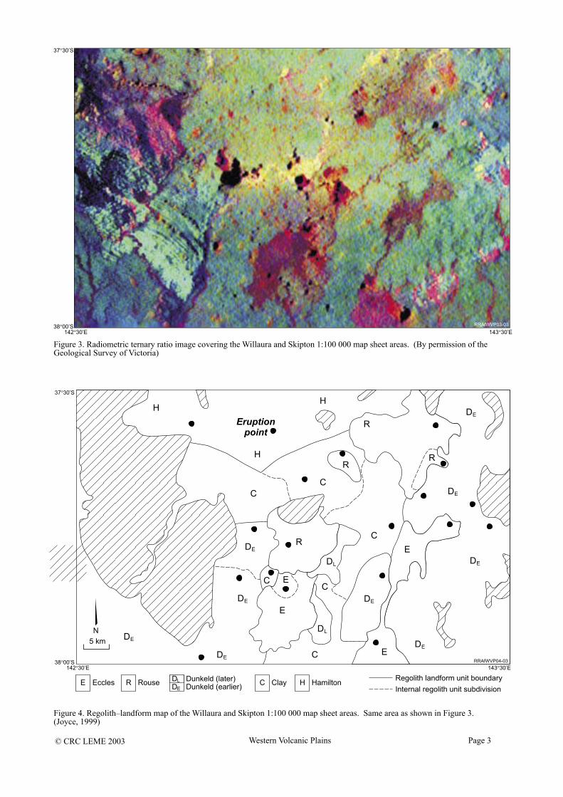
For this study a 1:250 000 radiometric ternary ratio image (Figure 3) was prepared by Moore and Bibby of the GSV, with the area of
© CRC LEME 2003 Western Volcanic Plains Page 3
Figure 3. Radiometric ternary ratio image covering the Willaura and Skipton 1:100 000 map sheet areas. (By permission of the Geological Survey of Victoria)
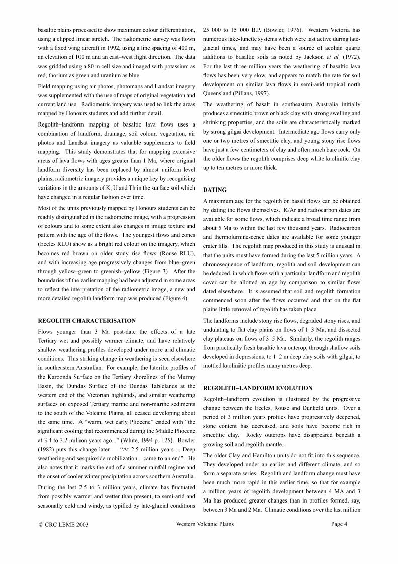
Figure 4. Regolith–landform map of the Willaura and Skipton 1:100 000 map sheet areas. Same area as shown in Figure 3. (Joyce, 1999)
© CRC LEME 2003 Western Volcanic Plains Page 4
basaltic plains processed to show maximum colour differentiation, using a clipped linear stretch. The radiometric survey was flown with a fixed wing aircraft in 1992, using a line spacing of 400 m, an elevation of 100 m and an east–west flight direction. The data was gridded using a 80 m cell size and imaged with potassium as red, thorium as green and uranium as blue.
Field mapping using air photos, photomaps and Landsat imagery was supplemented with the use of maps of original vegetation and current land use. Radiometric imagery was used to link the areas mapped by Honours students and add further detail.
Regolith–landform mapping of basaltic lava flows uses a combination of landform, drainage, soil colour, vegetation, air photos and Landsat imagery as valuable supplements to field mapping. This study demonstrates that for mapping extensive areas of lava flows with ages greater than 1 Ma, where original landform diversity has been replaced by almost uniform level plains, radiometric imagery provides a unique key by recognising variations in the amounts of K, U and Th in the surface soil which have changed in a regular fashion over time.
Most of the units previously mapped by Honours students can be readily distinguished in the radiometric image, with a progression of colours and to some extent also changes in image texture and pattern with the age of the flows. The youngest flows and cones (Eccles RLU) show as a bright red colour on the imagery, which becomes red–brown on older stony rise flows (Rouse RLU), and with increasing age progressively changes from blue–green through yellow–green to greenish–yellow (Figure 3). After the boundaries of the earlier mapping had been adjusted in some areas to reflect the interpretation of the radiometric image, a new and more detailed regolith landform map was produced (Figure 4).
REGOLITH CHARACTERISATION
Flows younger than 3 Ma post-date the effects of a late Tertiary wet and possibly warmer climate, and have relatively shallow weathering profiles developed under more arid climatic conditions. This striking change in weathering is seen elsewhere in southeastern Australian. For example, the lateritic profiles of the Karoonda Surface on the Tertiary shorelines of the Murray Basin, the Dundas Surface of the Dundas Tablelands at the western end of the Victorian highlands, and similar weathering surfaces on exposed Tertiary marine and non-marine sediments to the south of the Volcanic Plains, all ceased developing about the same time. A “warm, wet early Pliocene” ended with “the significant cooling that recommenced during the Middle Pliocene at 3.4 to 3.2 million years ago...” (White, 1994 p. 125). Bowler (1982) puts this change later — “At 2.5 million years ... Deep weathering and sesquioxide mobilization... came to an end”. He also notes that it marks the end of a summer rainfall regime and the onset of cooler winter precipitation across southern Australia.
During the last 2.5 to 3 million years, climate has fluctuated from possibly warmer and wetter than present, to semi-arid and seasonally cold and windy, as typified by late-glacial conditions
25 000 to 15 000 B.P. (Bowler, 1976). Western Victoria has numerous lake-lunette systems which were last active during late-glacial times, and may have been a source of aeolian quartz additions to basaltic soils as noted by Jackson et al. (1972). For the last three million years the weathering of basaltic lava flows has been very slow, and appears to match the rate for soil development on similar lava flows in semi-arid tropical north Queensland (Pillans, 1997).
The weathering of basalt in southeastern Australia initially produces a smectitic brown or black clay with strong swelling and shrinking properties, and the soils are characteristically marked by strong gilgai development. Intermediate age flows carry only one or two metres of smectitic clay, and young stony rise flows have just a few centimeters of clay and often much bare rock. On the older flows the regolith comprises deep white kaolinitic clay up to ten metres or more thick.
DATING
A maximum age for the regolith on basalt flows can be obtained by dating the flows themselves. K/Ar and radiocarbon dates are available for some flows, which indicate a broad time range from about 5 Ma to within the last few thousand years. Radiocarbon and thermoluminescence dates are available for some younger crater fills. The regolith map produced in this study is unusual in that the units must have formed during the last 5 million years. A chronosequence of landform, regolith and soil development can be deduced, in which flows with a particular landform and regolith cover can be allotted an age by comparison to similar flows dated elsewhere. It is assumed that soil and regolith formation commenced soon after the flows occurred and that on the flat plains little removal of regolith has taken place.
The landforms include stony rise flows, degraded stony rises, and undulating to flat clay plains on flows of 1–3 Ma, and dissected clay plateaus on flows of 3–5 Ma. Similarly, the regolith ranges from practically fresh basaltic lava outcrop, through shallow soils developed in depressions, to 1–2 m deep clay soils with gilgai, to mottled kaolinitic profiles many metres deep.
REGOLITH–LANDFORM EVOLUTION
Regolith–landform evolution is illustrated by the progressive change between the Eccles, Rouse and Dunkeld units. Over a period of 3 million years profiles have progressively deepened, stone content has decreased, and soils have become rich in smectitic clay. Rocky outcrops have disappeared beneath a growing soil and regolith mantle.
The older Clay and Hamilton units do not fit into this sequence. They developed under an earlier and different climate, and so form a separate series. Regolith and landform change must have been much more rapid in this earlier time, so that for example a million years of regolith development between 4 MA and 3 Ma has produced greater changes than in profiles formed, say, between 3 Ma and 2 Ma. Climatic conditions over the last million
© CRC LEME 2003 Western Volcanic Plains Page 5
years appear to be incapable of producing the deep kaolinitic profiles found on the Clay and Hamilton units, regardless of how long the younger basalt flows were exposed.
APPLICATION OF THE REGOLITH MAPPING
The map developed from field work, air photos, Landsat imagery, and in particular radiometric imagery, provides information which can be used to interpret the landscape evolution of the area. Correlation of RLUs with available K/Ar and radiocarbon dates allows ages to be assigned to flows and also to eruption points. Estimates can then be made of flow volumes and the distribution of eruption centres through time and space (Joyce, 1987). This has an immediate application in determining volcanic risk in Western Victoria (Joyce, 2001).
Without regolith mapping to provide an indication of the age of regolith and lava flows, most of the weathered flows greater than 1 Ma, which make up much of the Plains, could not be mapped in detail and so such deductions had not been made in the past. Now the movement of volcanic centres with time can be traced and predictions made about the time and location of any further activity. Using regolith mapping the volcanic evolution of the Newer Volcanic Province of southeastern Australia can be described in greater detail than has been possible in the past.
REFERENCES
Bowler, J.M., 1976. Aridity in Australia: age, origins and expression in aeolian landforms and sediments. Earth Science Reviews, 12: 279-310.
Bowler, J.M., 1982. Aridity in the late Tertiary and Quaternary of Australia. In: W.R. Barker and P.J.M. Greenslade (Editors). Evolution of the flora and fauna of arid Australia. Peacock Publications, Frewville, South Australia. pp. 35-45.
Everett, A. 1869. Victoria: distribution of forest trees. Revision of colour map, engraved by William Slight under direction of R. Brough-Smyth F.G.S. in 1866.
Moore, D. and Bibby, D., 1998. Ballarat 1:250 000 Radiometric Ternary Ratio image. Department of Natural Resources and Environment, Victoria.
Gibbons, F.R. and Gill, E.D., 1964. Terrains and soils of the basaltic plains of far western Victoria. Proceedings of the Royal Society of Victoria, 77: 387-395.
Jackson, M.L., Gibbons, F.R., Syers, J.K. and Mokma, D.L., 1972. Eolian influences on soils developed in a chronosequence of basalts of Victoria, Australia. Geoderma, 8: 147-163.
Joyce, E.B., 1982. Soils and landscape terrains of the volcanic plains of Western Victoria. Abstracts, Section 21, Geographical Sciences, ANZAAS, Macquarie University. p. 36.
Joyce, E.B., 1987. Volcanic activity through time in young basaltic provinces using regolith and landform mapping. Abstract volume, Hawaii Symposium on How Volcanoes Work, Hilo, Hawaii, January 19-25. pp. 1987, 127.
Joyce, E.B., 1999. A new regolith landform map of the Western Victorian volcanic plains, Victoria, Australia, In: G. Taylor
and C. Pain (Editors). Proceedings of Regolith ’98, New Approaches to an Old Continent. CRC LEME, Perth, Australia. pp. 117-126.
Joyce, E.B., 2001. The young volcanic province of southeastern Australia: volcanic risk evaluation and the community. In: C. Stewart (Editor). Proceedings of the Cities on Volcanoes 2 Conference, Auckland, New Zealand, 12-14 February 2001. Institute of Geological and Nuclear Sciences Information Series 49. p.70.
Land Conservation Council of Victoria, 1980. Ballarat Study Area. Land Conservation Council of Victoria, Melbourne.
Maher, J.M. and Martin, J.J., 1987. Soils and landforms of South Western Victoria. Part 1 Inventory of soils and their associated landscapes. State Chemistry Laboratory, Department of Agriculture and Rural Affairs, Victoria. Research Report series No. 40.
Ollier, C.D. and Joyce, E.B., 1986. Regolith terrain units of the Hamilton 1:1 000 000 sheet area, Western Victoria. Bureau of Mineral Resources, Geology and Geophysics (Geoscience Australia), Canberra. Record 1986/33. 55pp.
Pillans, B., 1997. Soil development at snail’s pace: evidence from a 6 Ma soil chronosequence on basalt in north Queensland, Australia. Geoderma, 80: 117-128.
Taylor, D.H. and Joyce, E.B., 1996. Ballarat 1:100,000 regolith–exploration map report. Geological Survey of Victoria. Technical Record 1996/4.
White, M.E., 1994. After the greening — the browning of Australia. Kangaroo Press, Kenthurst NSW. 288pp.