Embed Size (px)
Citation preview

WESTPORTPort and Environs Strategy
WESTPORT:Preparing for the Strategy

32
Introduction 5
The Port of Fremantle 7
What has been done before? 14
What does Westport aim to achieve? 18
The Westport Vision 18
Aims 18
Objectives 18
Proposed approach 19
What are the proposed key questions? 20
Deliverables 21
Question one: 22
What problems are we trying to solve and what opportunities are we trying to capture? 23
Question two: 28
Where do new port facilities need to be located in the Outer Harbour? 29
Question three: 32
How big an area is required for new port facilities in the Outer Harbour? 33
Question four: 35
How do we make the best use of adjacent and supporting land to stimulate future jobs? 36
Question five: 40
How do we connect new port facilities with the surrounding environment to facilitate 41 imports and exports?
Question six: 43
How do we stage new port facilities so they are operationally and financially sustainable? 44
Question seven: 45
When will new port facilities be needed? 46
Who’s involved with Westport 47
How you can help us 50
What happens next? 51
Contents
32
Figure 1: Westport steps 4
Figure 2: Fremantle Inner Harbour 6
Figure 3: Total port trade 2006-07 to 2016-17 7
Figure 4: Cruise vessels visiting Fremantle Port 2006-07 to 2016-17 8
Figure 5: Principal Areas of Trade 2016-17 Mass tonnes (000’s) 9
Figure 6: Container Trade Comparison 2011-12 to 2016-17 9
Figure 7: New Motor Vehicles - Imports 2007-08 to 2016-17 9
Figure 8: Live Sheep Exports 2007-08 to 2016-17 9
Figure 9: Fremantle Outer Harbour 10
Figure 10: Principal Commodities Imports/Exports 2016-17 11
Figure 11: Existing Freight Network 12
Figure 12: Freight, Trade and Defence 13
Figure 13: Port locations investigated 15
Figure 14: Port options investigated in the Outer Harbour 17
Figure 15: Infrastructure Australia’s Assessment Framework 19
Figure 16: Key questions 20
Figure 17: Westport deliverables 21
Figure 18: Western Australia’s long term population forecasts 24
Figure 19: Cockburn Sound Fisheries 26
Figure 20: Seagrass health 26
Figure 21: The zones and locations of seagrass health and water quality monitoring sites in Cockburn 27 Sound and the locations of reference sites in Warnbro Sound
Figure 22: Kwinana Strategic Industrial Area 38
Figure 23: Industrial Integration in 2013 - Kwinana Cluster 39
Figure 24: Peel Food Zone 42
Figure 25: Westport Governance Structure 48
Figure 26: Westport Taskforce Members 49
Figure 27: Preparing for the Strategy Timeline 50
Figure 28: Westport milestones 51
Figures

54
WESTPORT WANTS YOUR INPUT
We are planning a future freight system to support the Western Australian economy, centred on new port facilities
in the Outer Harbour at Kwinana.
We want your help to ensure we have the best information to plan for our future.
These are the steps where you can input into the process.
Legend
Open for consultation
For information
Figure 1: Westport steps
December2017
Preparing for a strategy
February 2018
What you have told us
February to August 2018
Website updates
August 2018
What we have found so far
October 2018
How we will assess the options
June 2019
Westport Strategy - Consultation Draft
September 2019
Westport Strategy - Final Report

54
To ensure the State’s future trade needs are met, well-planned port facilities are essential. The State Government is committed to planning for the Outer Harbour at Kwinana and the associated road and rail links as part of a long term integrated transport plan for the State.
The Westport: Port and Environs Strategy will provide guidance to the Government on the planning, development and growth of the Port of Fremantle at the Inner and Outer Harbours, the required rail and road networks, and the potential for the Port of Bunbury to contribute to the handling of the growing trade task.
The Westport Taskforce will develop a long term integrated solution to Perth and the surrounding regions’ freight, logistics and defence needs. We will look at how our growing trade may be handled into the next century – and how we can remain globally competitive. The Westport Strategy will guide the planning, development and growth of the Port of Fremantle (Inner and Outer Harbours) and identify the required port, rail, road and intermodal facilities to keep WA an attractive place to do business.
We will aim to answer many of the key strategic policy questions driving discussion on the need for future port infrastructure but will also look at the opportunities for the State, such as tourism and defence industries, as well as consider issues that extend beyond, and have a bearing on the port such as landside logistics, land use synergies, the environment, jobs and economic development.
The Westport Taskforce contains a diverse range of expertise and opinion from many organisations that have a vested interest in how the port – and our State – freight strategy develops.
Many people are interested in how the future port will develop and this paper, Preparing for the Strategy seeks input to build consensus on the proposed approach to developing the Westport Strategy.
It makes sense to capture the views, knowledge and skills of interested parties early in the process. We will use a series of questions to help us identify the problems we are trying to solve and the opportunities that may be available. It will also examine any constraints.
What is this paper about?This paper sets the scene for the Westport Strategy and shows how it will be developed through describing:
• An overview of Fremantle Port and its planning history
• What Westport aims to achieve
• Proposed question-based approach
• Who is involved with the Westport Taskforce
• How you can help us
• What happens next
What is this paper not about?It is far too early to provide preliminary answers to questions about port facilities, location and timing.
At this stage we cannot provide the definitive answers regarding medium term access to the Inner Harbour, the development of North Fremantle and Victoria Quay, rail access in the Western Trade Coast (see Feature item one) or stevedore leases.
However, these issues will be considered during the Westport process.
The Strategic Industrial Area at Kwinana and State Agreements will continue and be unaffected by the Westport process.
Introduction

76
FEATURE ITEM ONE: ESTATES WITHIN THE WESTERN TRADE COASTThe Western Trade Coast is the State’s premier industrial area containing the only strategic industrial land in the Perth metropolitan region that can accommodate new heavy industries and expansions to existing heavy industries.
The Western Trade Coast encompasses the Kwinana Industrial Area, Rockingham Industry Zone, Latitude 32, and the Australian Marine Complex (AMC).
The Western Trade Coast generates around $15 billion annually and employs approximately 11,000 people directly and 26,000 people indirectly. When fully developed, the Western Trade Coast is expected to create up to 22,000 direct jobs and have a total output of about $28 billion.
For more information about the Western Trade Coast visit: http://www.westerntradecoast.wa.gov.au
Figure 2: Fremantle Inner Harbour

76
Fremantle’s role as a port began with the foundation of the Swan River Colony in 1829. The CY O’Connor-designed Inner Harbour has been operating at the mouth of the Swan River since 1897.
For more than a hundred years, the Port of Fremantle has played a leading role in shaping the physical, commercial and social environment of Western Australia.
As Western Australia’s largest general cargo port, operating from the Inner Harbour in Fremantle, and Outer Harbour in Kwinana, it is the gateway for most of the imported goods used in our homes and businesses.
Figure 3: Total port trade 2006-07 to 2016-17
Almost everything we use comes through the port; our food, electronics and motor vehicles, to name a few. Therefore, if the port is not located and operated efficiently, these things may increase in price and become limited in availability.
The Port of Fremantle is also a vital link to world markets for our exporters.
In 2016-17, the port handled 81.7 per cent of the State’s seaborne imports by value and 10.2 per cent by value of seaborne exports. The total value of trade was $26.066 billion, which represents an hourly average of $2.98 million.
The Port of Fremantle
Imports 12.010 13.009 12.545 12.103 13.102 13.663 14.030 13.909 15.078 14.684 14.466
Exports 13.043 13.122 14.043 14.065 13.043 14.579 17.950 19.597 20.764 20.140 20.845
Total 25.053 26.131 26.603 26.168 26.145 28.242 31.980 33.506 35.842 34.824 35.312
98
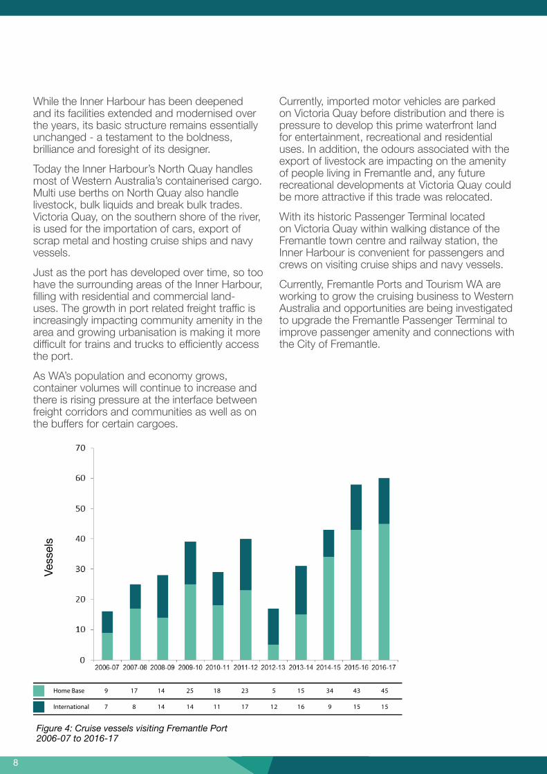
While the Inner Harbour has been deepened and its facilities extended and modernised over the years, its basic structure remains essentially unchanged - a testament to the boldness, brilliance and foresight of its designer.
Today the Inner Harbour’s North Quay handles most of Western Australia’s containerised cargo. Multi use berths on North Quay also handle livestock, bulk liquids and break bulk trades. Victoria Quay, on the southern shore of the river, is used for the importation of cars, export of scrap metal and hosting cruise ships and navy vessels.
Just as the port has developed over time, so too have the surrounding areas of the Inner Harbour, filling with residential and commercial land-uses. The growth in port related freight traffic is increasingly impacting community amenity in the area and growing urbanisation is making it more difficult for trains and trucks to efficiently access the port.
As WA’s population and economy grows, container volumes will continue to increase and there is rising pressure at the interface between freight corridors and communities as well as on the buffers for certain cargoes.
Currently, imported motor vehicles are parked on Victoria Quay before distribution and there is pressure to develop this prime waterfront land for entertainment, recreational and residential uses. In addition, the odours associated with the export of livestock are impacting on the amenity of people living in Fremantle and, any future recreational developments at Victoria Quay could be more attractive if this trade was relocated.
With its historic Passenger Terminal located on Victoria Quay within walking distance of the Fremantle town centre and railway station, the Inner Harbour is convenient for passengers and crews on visiting cruise ships and navy vessels.
Currently, Fremantle Ports and Tourism WA are working to grow the cruising business to Western Australia and opportunities are being investigated to upgrade the Fremantle Passenger Terminal to improve passenger amenity and connections with the City of Fremantle.
Home Base 9 17 14 25 18 23
International 7 8 14 14 11 17
5 15 34 43 45
12 16 9 15 15
Figure 4: Cruise vessels visiting Fremantle Port 2006-07 to 2016-17

98
Fremantle Port - Fact Sheet
Imports 344,453 343,900 363,917 382,932 369,072 368,656
Exports 312,459 326,382 339,410 360,563 346,035 347,293
Total 656,912 670,282 703,327 743,495 715,107 715,949
Full Containers 329,999 329,964 340,943 355,852 347,380 343,099
Full Containers 160,758 174,520 205,996 222,454 202,381 214,865
TEU - Twenty-foot equivalent unitGrowth p.a. 5 years - 1.7%
Vehicles 104,313 75,348 94,933 92,545 104,539 123,483 109,837 101,611 101,632 93,094 Head 2.98 3.10 2.23 2.27 1.79 1.70 1.75 1.78 1.65 1.60
Figure 5: Principal Areas of Trade 2016-17 Mass tonnes (000’s)
Figure 6: Container Trade Comparison 2011-12 to 2016-17
Figure 7: New Motor Vehicles - Imports 2007-08 to 2016-17
Figure 8: Live Sheep Exports 2007-08 to 2016-17
Africa 432, 1.2%
Central and South America 109, 0.3%
Other 103, 0.3%
East Asia 12679, 35.9%
South-East Asia 8895, 25.2%
Middle East 4642, 13.1%
Australia 3435, 9.7%
UK and Europe 1606, 4.5%
Southern Asia 1207, 3.4%
North America 1147, 3.2%
South Paci�c 1102, 3.1%
(from http://www.fremantleports.com.au)

1110
Although there are uncertainties about the likely rate of growth of container volumes at the Inner Harbour and the associated impacts of transport activity on the community, it is inevitable that in the future additional port and related landside facilities will be needed.
The Outer Harbour at Kwinana is home to bulk terminals handling bulk products and liquids such as alumina, grain, minerals and fuels.
The Outer Harbour is within the Western Trade Coast and close to the Australian Marine Complex and the Garden Island Naval Base. There may be opportunities for the Outer Harbour facilities to synergise with these operations into the long term.
Figure 9: Fremantle Outer Harbour and adjacent area
The Western Trade Coast is the State’s premier industrial estate. The heavy industry core is located within the Kwinana Industrial Area with many industries sharing their by-products. The existing infrastructure, utilities and functional synergies are essential for the ongoing operation, and future expansion, of this valuable asset.
While considering the future of ports at Fremantle and Kwinana, it is important to also consider the contribution that Bunbury Port could make to the future freight system.

1110
Only two hours by road south of Perth, Bunbury has good links to the metropolitan area and may provide more options to achieve the highest and best use of our ports and associated land assets.
For a port to be globally competitive, it needs to be able to move cargos quickly from the ship to the customer. Westport will need to plan for the movement of goods to and from the port facilities so they can efficiently reach their markets locally, regionally, interstate or overseas. To this end our freight network and intermodal system will need to allow and support future growth.
A key issue will be to plan for future trade growth, while making the best use of our marine and landside assets to serve the long term needs of Western Australia.
At the same time, the Westport Strategy must ensure the protection of existing strategic industries and land uses (including strategic heavy industrial land uses in Kwinana) to maintain these operations and provide for future expansion opportunities.
Iron Ore 12%
Alumina 9%
Phosphates / Fertilisers 3%
Caustic Soda 3%
Cement Clinker 2%
Chemicals 2%
Animal Feed 2%
Metal Scrap 1%
Sulphur 1%
Iron and Steel 1%
Manufactures of Metal 1%
Bauxite 1%
Grain 20%
Petroleum Products 25%
Other Commodities 17%
Figure 10: Principal Commodities Imports/Exports 2016-17

1312
Figure 11: Existing Freight Network

1312
Figure 12: Freight, Trade and Defence
ManglesBay
GardenIsland
Woodman Point
North Mole
RIVER
CarnacIsland
WARNBROSOUND
OwenAnchorage
South Mole
SWAN
Figure 12: Potential trade, freight and defence opportunities
Westport Taskforce
0 1 2 3 4
kilometres
N
Produced by GeoSpatial Research and Modelling,Department of Planning, Lands and Heritage,on behalf of the Western Australian Planning Commission.Copyright © December 2017
\\dopgisfilesvr02\iProducts\Perth\WestportFreightTradeDefence_Precincts.mxd
Base information supplied byWestern Australian Land Information AuthoritySLIP 944-2017-1
Legend
Industrial zoning
Freight road
Transport network
Opportunities
Industrial development
Port development
New industry
Urban regeneration
Tertiary education sector
Connections into and away fromWestern Australia
Port Develop new port facility
• infrastructure quality• productivity• economic growth• better infrastructure
services• better use of existing
infrastructure• higher productivity
New industry Commencement of
‘new’ industries (defence) • economic growth• greater innovation• higher employment• improved investment
environment• entrepreneurship• more skilled
Urban regeneration Transition of inner harbour and Greater tourism opportunities • better city planning• increased supply and
diversityof housing
• better amenity• economic growth
Tertiary education sector Specialised tertiary education
and training • skilled workforce• productivity• economic growth• greater innovation
Connections Greater connections into and away from Western Australia • higher employment• more effective investment• economic growth
Industrial development Mix of compatible, well planned
industries • productivity• economic growth• greater innovation• higher employment
Transport network Coordinated and integrated
freight network• infrastructure quality• productivity• economic growth• better infrastructure
services• better use of existing
infrastructure• higher productivity
Westport: Preparing for the StrategyDiscussion Paper No. 1
1514
The future of the Port of Fremantle and the likely rate of growth of container volumes at the Inner Harbour has been the subject of modelling, planning and debate for decades.
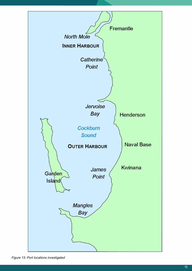
Successive Governments have been supportive of exploring options to expand to the Outer Harbour, with significant study and analysis undertaken at various times. A rundown of previous planning work carried out for the Outer Harbour is summarised in this chapter.
Location
Since the 1960s, Cockburn Sound has been identified as the most appropriate location for additional container and general cargo facilities to cater for the overflow of trade from the Inner Harbour.
A number of studies have investigated various locations at Mangles Bay, Point Catherine and North Mole at Fremantle as well as North Fremantle, Catherine Point, Jervoise Bay, Naval Base (Kwinana) and Kwinana/Rockingham.12345
1Perth Metropolitan Region – a review of the proposed port facility at Mangles Bay final report was published by the Town Planning Department in 1984,
2Fremantle Ports internal study
3The Future Port Options Auxiliary Study (1991)
4Future Port Options Naval Base/Kwinana Future Port Site Study (1994)
5Fremantle Rockingham Industrial Area Regional Strategy (FRIARS), released in April 2000
6Fremantle Rockingham Industrial Area Regional Strategy (FRIARS), released in April 2000
What has been done before?
In 1996, Naval Base (Kwinana) was endorsed by Cabinet as the preferred location for future container port facilities as it:
• met port, land use and transport planning needs while minimising environmental impacts;
• provided a buffer between port, industry and urban uses;
• integrated with the area’s existing industry; and
• met ship operational criteria.
Rowley Road and Anketell Road were identified6 as the Primary Regional Roads to service the port facilities in the Outer Harbour and Kwinana Industrial Area.
1514
Figure 13: Port locations investigated
1716
8Strategic Assessment Report 2006
7The Metropolitan Freight Network Review (FNR)
Subsequently, in 1997 Fremantle Ports commenced planning for an expanded port facility in the Outer Harbour at Naval Base. The project was guided by a Steering Committee of State Government agencies, local government and industry representatives. At this stage, it was thought that additional port facilities would be needed by about 2017 but a review7 concluded that planning for an Outer Harbour should be brought forward.
In 2002, the Fremantle Port’s Outer Harbour Project commenced a ”triple bottom line’ strategic and detailed implementation plan for establishing overflow port facilities in the Outer Harbour with a view to addressing all barriers to development with five years”.
Nine options were considered revolving around three locations:
• Northern options - south of Mt Brown/Naval Base (Kwinana);
• Middle options - near the former BHP, now Fremantle Ports’ site; and
• Southern options near James Point.
With extensive consultation, these nine options underwent an integrated strategic assessment, taking into account economic, environmental and social factors. The preferred option was an offshore port at Naval Base (Kwinana).
Subsequently, in 2006, an integrated strategic assessment of four options (one land backed and three island options) in the Outer Harbour8 was undertaken. Two of the options were approved by Cabinet to go forward into the statutory approvals process.
Meanwhile, the option of a private port at James Point was explored.
Work on the other options continued with extensive technical studies considering, in detail, the marine and terrestrial elements and implications.
More recently, the City of Kwinana has developed a further option - the Indian Ocean Gateway. This is a land backed two stage facility adjacent to the southern border of the Australian Marine Complex.
We will consider all the work that has been done before in developing these various port options. The Taskforce will identify areas where information is out of date and update studies to include the impact of new industries in the Outer Harbour, such as the desalination plant.

1716
Fig 14: Port options: previous investigations
City of Cockburn
City of Kwinana
ROCKINGHAM
ROAD
Westport Taskforce
0 0.3 0.6 0.9 1.2
kilometres
N
Legend
Port option 1
Port option 2
Port option 3
Port option 4
Port option 5
Port option 6
Port option 7
Industrial zoning
Freight railway
Freight road
Local governmentboundary
Produced by GeoSpatial Research and Modelling,Department of Planning, Lands and Heritage,on behalf of the Western Australian Planning Commission.Copyright © December 2017
\\dopgisfilesvr02\iProducts\Region\ProjectName\PortLocationsInvestigation_OuterHarbourOptions_v2.mxd
Base information supplied byWestern Australian Land Information AuthoritySLIP 944-2017-1
WestPort: Preparing for the Strategy Discussion Paper No.1
Naval Base
Cockburn
Sound
Figure 14: Port options investigated in the Outer Harbour

1918
Our vision, aims and objectives demonstrate how the Westport Strategy will encompass more than a port master plan.
The Westport Vision
• To provide a globally responsive, environmentally responsible and market competitive plan for Western Australia’s freight network to meet the South West region’s trade and growth objectives, supporting the needs of a growing population and creating sustainable jobs for future generations.
Aims
The Westport Strategy will
• plan for the Outer Harbour at Kwinana as part of a long term integrated transport plan for the State;
• position Western Australia as an attractive international investment opportunity, capable of capturing trade globally but particularly between Australia and the expanding economies in South East Asia and around the Indian Ocean;
• protect, as far as possible, our environmental and cultural heritage and amenity;
• make the best use of Fremantle, Kwinana and Bunbury ports and their environs to support a growing population and create jobs; and
• provide for efficient transport connections and intermodal hubs between port facilities and users.
Objectives
The objectives of the Westport Taskforce are to:
• engage with stakeholders and the community at all stages of the planning process;
• plan for a modern port in Cockburn Sound to meet Perth and the surrounding regions’ future growth for the next 50 to100 years;
• provide land use and transport plans that support port operations, compatible land uses, port users, the community and local economy;
• assess the commercial implications and logistics opportunities of future port infrastructure;
• maximise compatibility of port and landside development with the environment; and
• identify the expansion and preservation of industrial areas and technology parks to support economic development and future employment opportunities.
What does Westport aim to achieve?

1918
We will be using a question-oriented approach to guide our understanding of problems and opportunities. These questions will flow through the life of the two-year project, and be used to shape reports and technical papers.
Scenario analysis techniques will be applied to manage uncertainty and, spatial data will be used to provide clarity and guidance to the planning process.
This question-based methodology aligns with the first two stages of a nationally accepted approach to developing major infrastructure.9
This methodology will facilitate multi-agency, multi-disciplinary collaboration within the Westport Taskforce and guide external engagement.
There are many people who have extensive knowledge of ports, logistics, economic development, environment, land use, transport planning -and many other skills - that can provide valuable input into the Westport process.
The challenge will be in developing the methodology to capture diverse views, and subject them to rigor, so that through a strong process, the best outcomes may be determined for Western Australia. Westport will be an evidence-based planning process where multiple scenarios and data will be analysed and discussed when seeking consensus and providing the preferred options for the new port. At this stage we can’t predict the outcomes of the final result.
9 Infrastructure Australia, Assessment Framework, June 2017, p8 http://infrastructureaustralia.gov.au/policy-publications/publications/files/Assessment-Framework-June-2017.pdf )
Figure 15: Infrastructure Australia’s Assessment Framework
Proposed approach
STAGE 1
Problem Identification
and Prioritisation
STAGE 2
Initiative Identification and Options Development
STAGE 3
Business Case Development
STAGE 4
Business Case Assessment
STAGE 5
Post Completion Review

2120
What are the proposed key questions?
The proposed key questions are framed around high level port activities, but from these will flow a series of sub-questions that will cover a range of matters including environmental and social issues.
We will use quantitative data and population based projections as well as the knowledge and experience from Westport Taskforce members, along with stakeholder and community feedback, to find the answers to these questions.
Stage one: Problem identification and prioritisation
1. What problems are we trying to solve and what opportunities are we trying to capture?
Stage two: Initiative identification and options development
2. Where do port facilities need to be located in Fremantle, Kwinana and Bunbury?
3. How big an area is required for new port facilities in the Outer Harbour?
4. How do we make the best use of adjacent and supporting land to stimulate future jobs?
5. How do we connect new port facilities with the surrounding environment to facilitate imports and exports?
6. How do we stage new port facilities so they are operationally and financially sustainable?
7. When will new port facilities be needed?
The information collected in response to these questions will identify a number of port options. These options will be assessed to determine a preferred option.
Figure 16: Key questions
The Westport Taskforce consists of state and local government agencies, as well as representatives from industry, academic, environment and community organisations.
At the end of Stage two, a number of port options will be identified and assessed. Feedback on the proposed assessment criteria will be sought through a consultation process before the assessment process is commenced.
With the identification of preferred option(s), this project will be complete and will be strategically placed to go to the next stage of developing a business case at the relevant time.

2120
Approximate Date Deliverable
December 2017* Westport: Preparing for the Strategy discussion paper
February 2018
Westport: What you have told us
A summary of the feedback received in response to the Preparing for the Strategy discussion paper showing the updated project methodology.
February - August 2018
Consultation on specific port planning issues with local government, academia, industry, environmental and community groups. Progress updates will be provided on the Westport website.
August 2018 *
Westport: What we have found so far
A compendium of answers to questions one to seven with feedback sought on the assessment criteria to be used to assess the port options identified.
October 2018
Westport: How we will assess the options
A summary of the feedback received in response to What we have found so far and how it has been addressed within the assessment criteria.
October 2018 - June 2019
The various port options will be assessed using the criteria to identify a preferred option.
June 2019 * Westport: Port and Environs Strategy - Consultation Draft
September 2019 Westport: Port and Environs Strategy - Final Report
Figure 17: Westport deliverables
Deliverables
The development of the Westport Strategy will involve consultation during all stages and will deliver a number of reports.
* Open for consultation

2322
Question one
2322
Identifying problems and opportunities will be critical in determining the type and scale of port facilities needed at the Outer Harbour.
Western Australia is a vast state covering a third of the continent with a population over 2.5 million. Approximately 80 per cent of people live in the growing Perth and Peel regions – where the population is expected to nearly double by 2050.
Access to Fremantle’s Inner Harbour is perceived to be increasingly constrained by surrounding residential development and additional port facilities will be needed in the long term to service the needs of the growing population.
Western Australia’s economy has traditionally been heavily dependent on the resource and agricultural sectors. With our State’s proximity to the expanding economies of South East Asia and around the Indian Ocean, there may be opportunities to strengthen these sectors, expand their activities to include more downstream processing and explore new industries to diversify our economy.
Ten new offshore patrol vessels will be built for the Navy at the Australian Marine Complex and this could be an opportunity to attract more defence related jobs to WA.
Bunbury, Western Australia’s second largest city is two hours by road from Fremantle. It has excellent port facilities that could be used to complement the State’s overall freight task. Bunbury Port is currently undertaking a Master Planning process and this will be considered as part of the Westport process. The Westport Taskforce will investigate what benefits can be gained, or costs avoided, by moving current and future trades from Fremantle to Kwinana or Bunbury. Implications of additional freight transport costs will also be explored.
The Outer Harbour in Cockburn Sound has been identified as the preferred location for additional port facilities. The Outer Harbour has a thriving industrial zone adjacent to its existing bulk commodity berths and is also bordered by the Garden Island Naval Base and the Australian Marine Complex.
What problems are we trying to solve and what opportunities are we trying to capture?
2524
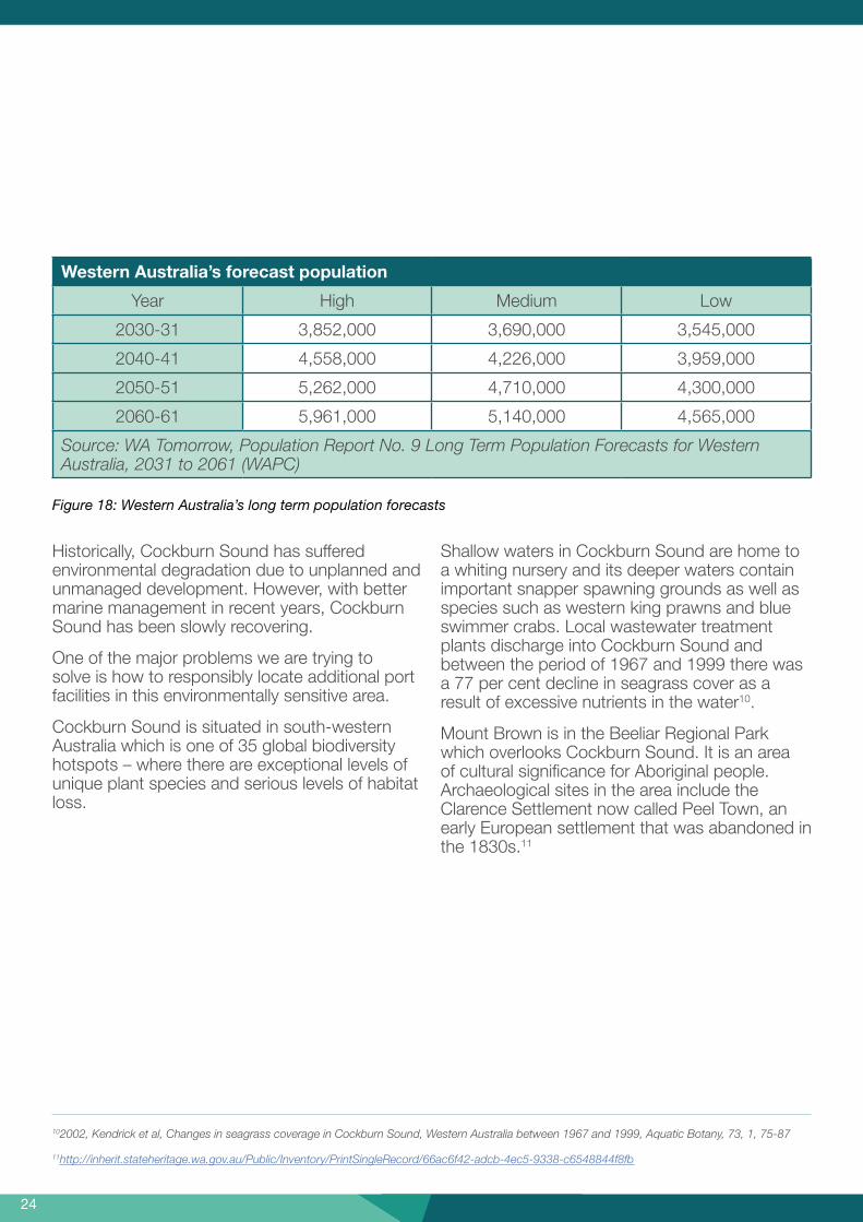
Historically, Cockburn Sound has suffered environmental degradation due to unplanned and unmanaged development. However, with better marine management in recent years, Cockburn Sound has been slowly recovering.
One of the major problems we are trying to solve is how to responsibly locate additional port facilities in this environmentally sensitive area.
Cockburn Sound is situated in south-western Australia which is one of 35 global biodiversity hotspots – where there are exceptional levels of unique plant species and serious levels of habitat loss.
Shallow waters in Cockburn Sound are home to a whiting nursery and its deeper waters contain important snapper spawning grounds as well as species such as western king prawns and blue swimmer crabs. Local wastewater treatment plants discharge into Cockburn Sound and between the period of 1967 and 1999 there was a 77 per cent decline in seagrass cover as a result of excessive nutrients in the water10.
Mount Brown is in the Beeliar Regional Park which overlooks Cockburn Sound. It is an area of cultural significance for Aboriginal people. Archaeological sites in the area include the Clarence Settlement now called Peel Town, an early European settlement that was abandoned in the 1830s.11
102002, Kendrick et al, Changes in seagrass coverage in Cockburn Sound, Western Australia between 1967 and 1999, Aquatic Botany, 73, 1, 75-87
11http://inherit.stateheritage.wa.gov.au/Public/Inventory/PrintSingleRecord/66ac6f42-adcb-4ec5-9338-c6548844f8fb
Western Australia’s forecast population
Year High Medium Low
2030-31 3,852,000 3,690,000 3,545,000
2040-41 4,558,000 4,226,000 3,959,000
2050-51 5,262,000 4,710,000 4,300,000
2060-61 5,961,000 5,140,000 4,565,000
Source: WA Tomorrow, Population Report No. 9 Long Term Population Forecasts for Western Australia, 2031 to 2061 (WAPC)
Figure 18: Western Australia’s long term population forecasts

2524
12https://www.der.wa.gov.au/images/documents/about/csmc/2016_Cockburn_Sound_Monitoring_and_Research_Programs.pdf
These are just some of the considerations that will need to be taken into account as part of the Westport process.
Our marine, terrestrial and cultural diversity helps to make our city beautiful and liveable. Therefore, the Westport Taskforce wants to make sure that decisions about future developments are environmentally and culturally responsible and based on sound scientific evidence.
Developing the Westport Strategy gives us the opportunity of looking at how we can make the highest and best use of our marine and land environments so that our economy can grow and diversify to support and provide jobs for future generations, while protecting, as far as possible, our marine, terrestrial and cultural assets.
We will need to take an iterative approach when planning and designing the development to balance and maximise economic, social and environmental outcomes.
As part of the Westport process we need to identify preferred supply chain options that will serve Western Australia for the next 50 to100 years. In this context, Question one will start to set the scene by:
• assessing the baseline and trends in the condition of our marine and terrestrial environment and identifying mitigation opportunities12;
• taking stock of what we have now in the way of population, land use, industry, jobs and infrastructure;
• examining our population and trade forecasts and identifying where future populations are planned to live and work;
• estimating the future trade task and where freight will go;
• monitoring industry trends to see if there are opportunities for WA;
• monitoring technological trends such as vessel size and autonomous vehicles to keep future options open;
• exploring, at a high level, opportunities to create jobs through co-locating industries that benefit from being near a port, attracting new industries and expanding synergies between industries; and
• developing a range of scenarios to help with the planning process.
This stage will start the conversation and enable Westport Taskforce members to identify the key pieces in the Westport jigsaw.

2726
MONITORING PROGRAM
Water quality
Phytoplankton
FishSediment quality
Introduced marinepests
Seagrass healthSeafood quality
Coastalgeomorphology
Birds
FEATURE ITEM TWO: MONITORING PROGRAMS FOR MEASURING ENVIRONMENTAL PERFORMANCEThe monitoring that is currently being undertaken in the Cockburn Sound marine area is summarised below.
Additionally, the Environmental Protection Authority (EPA) has established an environmental quality management framework for Cockburn Sound through the State Environmental (Cockburn Sound) Policy 2015.
The objective of the environmental quality management framework is to maintain environmental quality in order to protect the integrity and biodiversity of the marine ecosystems, and current and projected future societal uses of these waters, from the effects of pollution, waste discharges and deposits (EPA 2015).
The zones and locations of seagrass health and water quality monitoring sites in Cockburn Sound and the locations of reference sites in Warnbro Sound are shown in Figure 21.
Figure 19: Cockburn Sound Fisheries
Cockburn Sound Fisheries
Historically, Cockburn Sound is a commercial and recreational fishing area for Australian herring, garfish, squid, blue swimmer crabs, pink snapper and whiting. The various whiting species are found in abundance been seagrass meadows and sand or on sandy bottoms.
Cockburn Sound is the site of the largest known aggregations of pink snapper in the West Coast Bioregion and is critical for sustaining adequate breeding stocks of these long-lived and slow-growing fish.
Seagrass health
Seagrasses are the only flowering plants that can live underwater. They provide a habitat for small marine animals and also absorb nutrients helping to keep water clear. They are a key indicator of ecosystem health in the Sound.
Seagrass health is assessed by comparing seagrass shoot densities at each of 11 seagrass sites within Cockburn Sound against shoot densities measured at comparable reference sites in Warnbro Sound within the Shoalwater Islands Marine Park.
A large percentage of seagrass once present in Cockburn Sound has been lost. Most of this loss dates back to the 1970s and 80s. Despite the efforts made to clean up the Sound, seagrass beds have not re-generated to any meaningful degree (despite the reduction in pollution) and it is well-established that nutrient enrichment of the Sound has been largely responsible for the decline.
Figure 20: Seagrass health

2726
Figure 21: The zones and locations of seagrass health and water quality monitoring sites in Cockburn Sound and the locations of reference sites in Warnbro Sound

2928
Question two

2928
To get the best use from future port facilities in the Outer Harbour, we need to understand how any development in the area will interact with the surrounding marine and terrestrial environments as well as the wider supply chain.
This question will determine where within the Outer Harbour new port facilities should be located, how they should be configured to minimise short and long term environmental impacts and the types of trade they would be best to handle.
To answer this question, we need to recognise the characteristics of the marine environment in Cockburn Sound that could impact on the location and operation of new port facilities, such as ocean depth, sea currents, wind direction, sediment, dredging requirements, underwater terrain and cumulative environmental impacts and risks.
Similarly, we need to understand the terrestrial environment to ensure it is suitable to support the development of additional port facilities and landside infrastructure.
Feature item four summarises some of the characteristics that may influence the location of new port facilities.
Based on the analysis of marine and terrestrial characteristics, some locations in Cockburn Sound may prove to be better suited for development.
As detailed previously in this document, a number of studies have been undertaken to identify potential sites for port facilities in Cockburn Sound. This work will be reviewed to see what is still relevant, identify areas where information is out of date and update studies to include the impact of new industries in the Outer Harbour and Kwinana Industrial Area, such as the desalination plant.
We are also aware of environmental studies that have recently been undertaken by academia, industry and environmental groups. These studies will be useful in informing the Westport process.
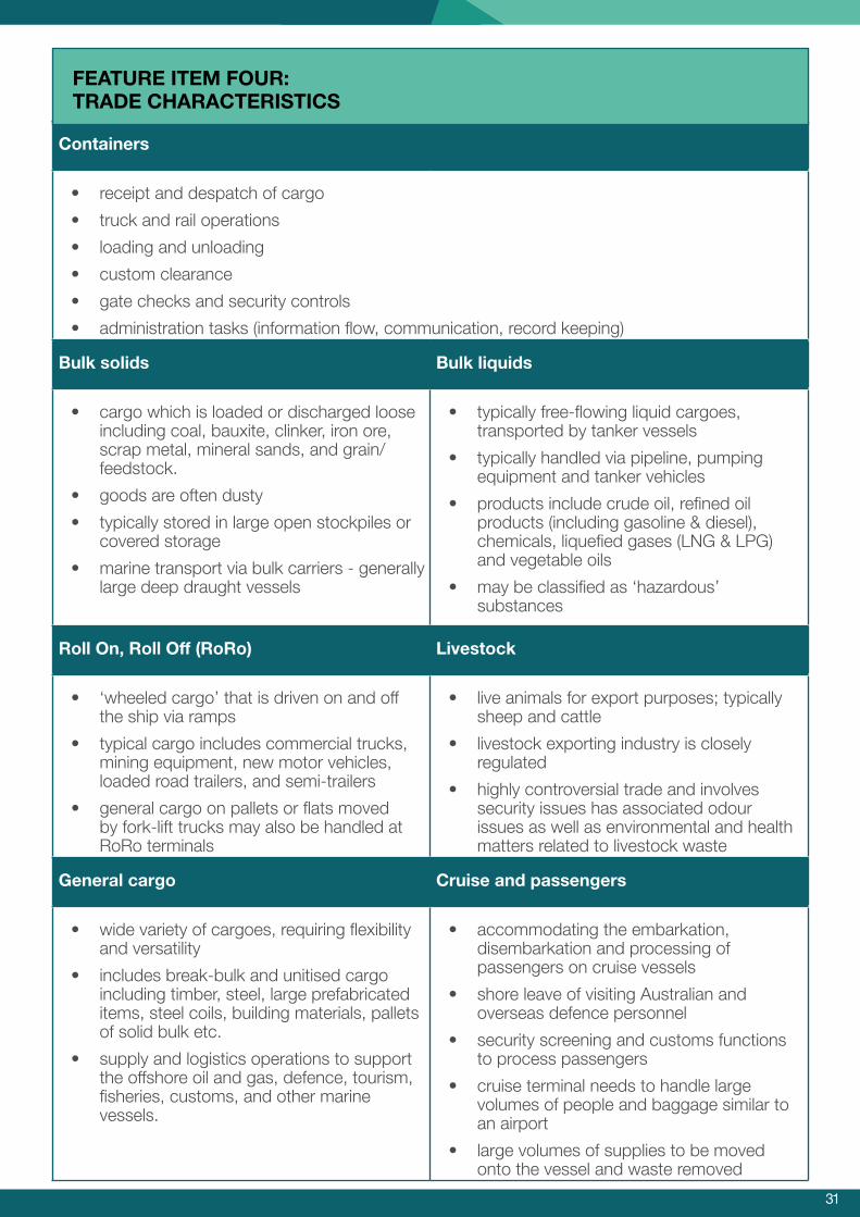
The Inner Harbour currently handles containers, bulk commodities, roll-on roll-off vehicles (RoRo), general cargo, liquids and livestock and hosts cruise and defence vessels. We need to be clear about the characteristics of each of these trades including how much space and the type of facilities they require to operate efficiently, their customers and primary markets and whether this can be facilitated at Kwinana. Feature item five provides an overview of the general characteristics of these trades.
The Outer Harbour is co-located with the State’s premier industrial estate and only metropolitan heavy industry zone. Kwinana is a major employment hub with the land being valuable for heavy industries especially those that need or benefit from being located adjacent to a port. Work will be undertaken to determine what these industries may be - now and in the future.
The Westport Strategy will provide a long term integrated solution to Perth and the surrounding regions’ freight, logistics and defence needs. It therefore needs to be able to respond flexibly to future technologies that could influence port design and the needs of new industries.
The information collated as part of the Westport process, may suggest that better outcomes could be achieved if trades were shared between Fremantle, Kwinana and Bunbury.
Where do new port facilities need to be located in the Outer Harbour?
3130
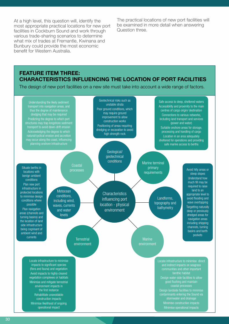
FEATURE ITEM THREE: CHARACTERISTICS INFLUENCING THE LOCATION OF PORT FACILITIESThe design of new port facilities on a new site must take into account a wide range of factors.
At a high level, this question will, identify the most appropriate practical locations for new port facilities in Cockburn Sound and work through various trade-sharing scenarios to determine what mix of trades at Fremantle, Kwinana and Bunbury could provide the most economic benefit for Western Australia.
The practical locations of new port facilities will be examined in more detail when answering Question three.
Characteristics in�uencing port
location - physical environment
Marine terminal primary
requirements
Landforms, topography and
bathymetry
Marine environment
Terrestrial environment
Metocean conditions,
including wind, waves, currents
and water levels
Geological/ geotechnical conditions
Coastalprocesses
Situate berths in locations with
benign ambient conditions
Plan new port infrastructure in
protected locations to minimise design conditions where
possiblePlan navigation
areas (channels and turning basins) and the location of land side infrastructure being cognisant of ambient wind and
currents
Avoid hilly areas or steep slopes
Understand how much �ll may be required to raise
land to an appropriate level to avoid �ooding and wave overtopping
Targetting naturally deep or previously dredged areas for navigation areas
including shipping channels, turning basins and berth
pockets
Geotechnical risks such as unstable strata
Poor ground conditions, which may require ground
improvement to allow construction works
Positioning of areas requiring dredging or excavation to avoid
high strength rock
Understanding the likely sediment transport into navigation areas, and
thus the degree of maintenance dredging that may be required
Predicting the degree to which port structures may trap longshore sediment
transport to avoid down-drift erosionAcknowledging the degree to which
natural/cyclical erosion and accretion may occur along the coast, in�uencing
planning onshore infrastructure
Locate infrastructure to minimise direct and indirect impacts on seagrass communities and other important
benthic habitatDesign water-side facilities to allow
good �ushing and maintain coastal processes
Design landside facilities to minimise contaminants entering the Sound via
stormwater and drainageMinimise construction impactsMinimise operational impacts
Safe access to deep, sheltered watersAccessibility and proximity to the main
centres of cargo origin/ destinationConnections to various networks,
including land transport and services (power and water)
Suitable onshore areas for storage, processing and handling of cargoLocation in an area adequately
sheltered for operations and providing safe marine access to berths
Locate infrastructure to minimise impacts to signi�cant species
(�ora and fauna) and vegetationAvoid impacts to highly cleared
vegetation complexes or habitatsMinimise and mitigate terrestrial
environment impacts in the �rst instance
Rehabilitate unavoidable construction impacts
Minimise likelihood of ongoing operational impact
3130
Containers
• receipt and despatch of cargo
• truck and rail operations
• loading and unloading
• custom clearance
• gate checks and security controls
• administration tasks (information flow, communication, record keeping)
Bulk solids Bulk liquids
• cargo which is loaded or discharged loose • typically free-flowing liquid cargoes, including coal, bauxite, clinker, iron ore, transported by tanker vessels scrap metal, mineral sands, and grain/feedstock.
• typically handled via pipeline, pumping equipment and tanker vehicles
• goods are often dusty • products include crude oil, refined oil • typically stored in large open stockpiles or products (including gasoline & diesel),
covered storage chemicals, liquefied gases (LNG & LPG)
• marine transport via bulk carriers - generally and vegetable oils
large deep draught vessels • may be classified as ‘hazardous’ substances
Roll On, Roll Off (RoRo) Livestock
• ‘wheeled cargo’ that is driven on and off • live animals for export purposes; typically the ship via ramps sheep and cattle
• typical cargo includes commercial trucks, • livestock exporting industry is closely mining equipment, new motor vehicles, regulatedloaded road trailers, and semi-trailers • highly controversial trade and involves
• general cargo on pallets or flats moved security issues has associated odour by fork-lift trucks may also be handled at issues as well as environmental and health RoRo terminals matters related to livestock waste
General cargo Cruise and passengers
• wide variety of cargoes, requiring flexibility • accommodating the embarkation, and versatility disembarkation and processing of
• includes break-bulk and unitised cargo passengers on cruise vessels
including timber, steel, large prefabricated • shore leave of visiting Australian and items, steel coils, building materials, pallets of solid bulk etc. •
overseas defence personnel
security screening and customs functions • supply and logistics operations to support to process passengers
the offshore oil and gas, defence, tourism, fisheries, customs, and other marine vessels.
• cruise terminal needs to handle large volumes of people and baggage similar to an airport
• large volumes of supplies to be moved onto the vessel and waste removed
FEATURE ITEM FOUR: TRADE CHARACTERISTICS

3332
Question three

3332
Using the practical and feasible port locations identified in Question two, Question three will explore the footprint of the port facilities required to accommodate future trade.
To do this, Question three will involve examining options to transfer various cargoes between ship, shore and the wider freight network.
This question aims to identify the size of port facilities within the port gates.
Getting freight from the ship to the customer can involve many steps that vary for each trade.
For example, imported full containers are currently taken to unpacking points either:
• directly by truck; or
• indirectly by train from the North Quay Rail Terminal (NQRT) to Forrestfield and then by truck.
Containers for export undergo the same process in reverse.
This means that the port area has to be sufficient to handle a large number of containers on the port site as well as accommodating stevedores, trucks and a train terminal.
As Western Australia imports more goods than it exports, many empty containers are stored at container parks before being exported. Empty containers are a major export from the Inner Harbour and any new facilities will need to have good access to container parks.
The Fremantle Port’s Logistics Chain Movement includes imported and exported containers moved by road or rail between container terminals, container parks, intermodal terminals and quarantine approved premises (QAP).
How big an area is required for new port facilities in the Outer Harbour?

3534
The design of any new port facilities will need to consider these steps and whether containers will be:
a) unloaded onto trucks and trains at the port; or
b) transferred by rail or other means to an inland facility where they will be loaded onto trucks and trains.
The port design for scenario a) would require a very large area to accommodate containers, trucks and trains.
The port design for scenario b) would be much smaller, but would require a large inland facility to accommodate the containers, trucks and trains. It would also need an efficient method of transporting containers between the port and inland facility.
Each trade (livestock, cars, bulk goods etc) will need to be examined closely to devise the amount of land required inside the port and to determine an appropriate distance for any supporting infrastructure outside the port.
As part of analysis undertaken, we will examine how the designs of other global ports allow for their integration with surrounding uses.
In determining the answer to this question, the high level impacts that the port design and operating model could potentially have on the environment, community, economy and workforce access will also be explored.
Questions four, five and six will look at how the port facilities interact with land beyond the port gate.

3534
Question four

3736
This question relates to Fremantle, Kwinana and Bunbury ports.
In Fremantle, Victoria Quay is on the southern shore of the Inner Harbour. Ships berthed at its eastern end carry cars and scrap metal with large areas of river frontage being used to park new cars prior to distribution. In its central area, cruise ships and defence vessels moor alongside the large Fremantle Passenger Terminal. At its western end there is the modern Maritime Museum, a passenger railway station and popular weekend markets.
The potential for further revitalisation of Victoria Quav’s western end (e.g. tourism, commercial development, recreation and entertainment) is well recognised by Fremantle Ports and the City of Fremantle.
On the Inner Harbour’s northern shore, North Quay is home to container facilities, a rail terminal and is also where livestock and other trades are handled. With the decommissioning of a major fuel facility, to the north of Tydeman Road, there may be opportunities to review the long term use of some industrial land close to the beach.
However, any future use will need to consider the safety buffers around the port and the long term future of the Inner Harbour.
The Westport process will consider the wider planning activities associated with the potential development of Victoria Quay and North Fremantle.
In Kwinana, the Western Trade Coast and the Garden Island Naval Base will be adjacent to any future port facilities in Cockburn Sound.
Potentially, available land in the Western Trade Coast could be used to support industries that need to be located near a port. This could include defence related industries.
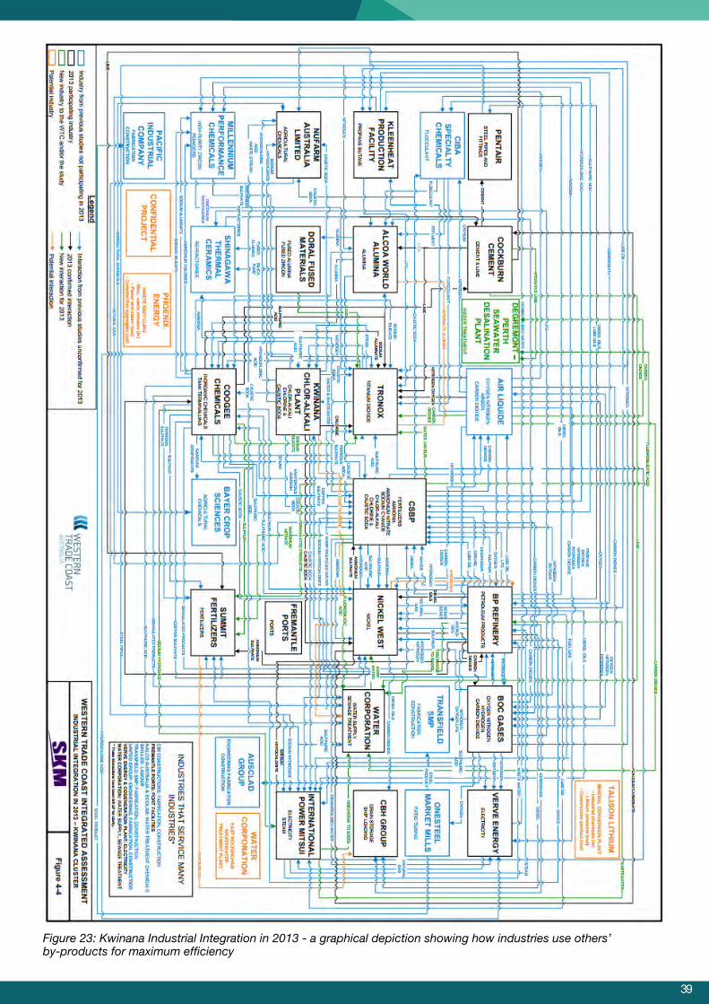
The Kwinana Strategic Industrial Area13 is the heavy industry centre for Perth. (Figure 22) The industries are very mature and operate ‘symbiotically’ by using others’ by-products for maximum efficiency. As can be seen in Figure 23, there are hundreds of interrelationships between businesses14.
Any new industries will need to complement those existing, so that highest and best use is made of this valuable industrial land.
The optimal role and size of a proposed intermodal terminal at Latitude 32 can be considered in the context of the port size (identified in response to Question three).
It may be possible to identify areas within the Western Trade Coast that could be used to attract particular industries to create technology parks to stimulate economic diversification.
Defence-associated industries as well as future port operations and port-related industries will require suitably skilled workers - potentially creating opportunities in the training sector.
13https://www.landcorp.com.au/Industrial-and-Commercial/Kwinana-Industrial-Area/
14https://www.landcorp.com.au/Documents/Projects/Industrial/Western%20Trade%20Coast/Western-Trade-Coast-Integrated-Assessment.pdf
How do we make the best use of adjacent and supporting land to stimulate future jobs?

3736
Ideally, workers will need to live near their work so it will be important to protect land use buffers so that industry and residences are separated.
Maintaining and expanding existing industries and diversifying into new areas of industry will rely on effective land use planning to:
• safeguard our environmental and cultural heritage;
• protect local sources of basic raw materials (to keep the cost of moving fill to build a port to a minimum); and
• provide flexibility to facilitate future job opportunities.
New port facilities at Kwinana and the opportunities for new industries and business development could be a game changer for WA.
In Bunbury, some opportunities may be created by relocating some trades from Fremantle. Bunbury Port is currently undertaking a Master Planning process and this will be considered as part of the Westport process.
For each of these ports, we will need to explore the potential relationship between the port and its neighbouring land by taking stock of what is there, identifying what should be there and exploring what could be there to create the best economic outcomes for Western Australia.
A key part of answering this question will be looking at what we can learn from other ports – both big and small – about supply chain efficiencies, symbiotic location of industries, social responsibility and environmental stewardship.
FEATURE ITEM FIVE: PORT SAFETY BUFFERS
Buffer guidelines provide controls for land use planning around the Inner Harbour. The aim is to ensure compatibility between the operational needs of the working port and surrounding uses.
The guidelines divide the areas close to the port into three zones.
Area 1 - excludes the establishment of additional sensitive uses other than residential.
Area 2 - allows the establishment of sensitive land uses but ensures that any land use located in Area 2 has an adequate level of design measures.
Area 3 - allows the establishment of sensitive land uses but ensures that any land use has relevant design measures implemented at the discretion of the Council.
For more in click here.
9
APPENDIX A

3938
Figure 22: Kwinana Strategic Industrial Area
3938
Figure 23: Kwinana Industrial Integration in 2013 - a graphical depiction showing how industries use others’ by-products for maximum efficiency

4140
Question five

4140
There are many development initiatives underway or being explored in the surrounding regions of the ports from Geraldton to Bunbury.
There may also be opportunities further afield hat require good linkages to the ports. We will ap these initiatives to enable us to see the big icture and identify potential missing links in the
uture freight network.
tmpf
A clear understanding of the freight demand from new port facilities in Kwinana to regional areas will be needed to make sure that corridors through the metropolitan area are suitable for the goods being transported along them e.g. high wide loads.
In Kwinana, the transport of goods from the port boundary may be possible by bulk product transport systems, so these will also be explored.
Using scenarios of trades operating from different ports, freight traffic will be followed from its origin to its destination to identify potential choke points along the supply chain and explore how they may be removed.
Modelling will be used to investigate various combinations of transport modes to get freight efficiently to its destination locally, regionally, interstate and overseas.
Future opportunities for freight may come from the Nambeelup area where the Transform Peel initiative identifies a 42,000 hectare Peel Food Zone, a 1,000 hectare Peel Business Park and an Integrated Water Resource Solution15 (Figure 24).
How do we connect new port facilities with the surrounding environment to facilitate imports and exports?

4342
Figure 24: Peel Food Zone
Particular attention will be paid to connecting ports to industrial areas, intermodal terminals and major freight routes. All of these facilities will require workers, so consideration will be given to the transport connections between residential areas and industrial areas.
As Western Australia’s population grows, it is important to protect freight corridors from urban encroachment in the long term and ensure that any new freight corridors consider environmental protection and community amenity. It may be possible that new technologies could be applied to mitigate noise, vibration, dust and other health impacts in the future and the latest research in this area will be explored.
The location of major utilities will be identified to explore opportunities to co-locate services in freight corridors such as power, water, gas and product pipelines, as well as future service and expansion requirements.
This question will therefore explore freight movements by road and rail across the metropolitan area and how they link to WA regions, interstate and potentially overseas via airports or other ports.
Freight supply chains are a system, often with each element of the system owned and controlled by a different operator. The scope and scale of the Westport process allows us for the first time to plan for an integrated network that optimises the efficiency of the system.

4342
Question six
4544
When we have identified the feasible options we need to understand how they can be developed in a commercially, operationally and financially sustainable manner.
This question will examine options for staging future port facilities and supporting infrastructure and, the methods available to fund future construction and operation. It is essential that current businesses are able to operate throughout the transition to any new port facilities.
With regard to staging, we may find that it is possible to relocate particular trades from the Inner Harbour to the Outer Harbour or Bunbury to maximise potential investment opportunities. This will help to make best use of the Inner Harbour as a high value, constrained location.
Working out the best options for staging will involve exploring various scenarios so we may estimate comparatively by an order of magnitude the:
• relative costs of each option e.g. low, medium, high; and
• potential opportunities for each option e.g. low, medium, high.
The impacts of having simultaneous container operations in both the Inner and Outer harbours will also need to be explored. If there was an excess in the overall container terminal capacity it would mean the terminals would not be operating economically and fees would be higher. This cost would ultimately need to be passed on to the consumer through higher priced goods.
The sunk costs of the Inner Harbour are very high as they are assets built for the long term. The longer the life of an asset, the cheaper it is to operate. However, there may be other more lucrative opportunities that are being missed by delaying a move and these will need to be explored.
With regard to funding future port facilities, in Fremantle, Kwinana or Bunbury, a key issue will be identifying how to make the ports attractive to investors while protecting the long term interests of the State. There are many models that can be examined to explore co-operation between public and private entities.
Access and pricing regimes for new port facilities would need to deliver the best overall economic outcomes for the State (and not just the port operator) while at the same time be able to compete with the more established facilities that have lower overheads.
We will investigate how similar staging challenges have been faced elsewhere with regards to the development of competing and/or replacement port facilities
By working through these issues, a high level appreciation of the comparative costs of the various staging options may be determined.
How do we stage new port facilities so they are operationally and financially sustainable?

4544
Question seven

4746
This question focuses on Fremantle’s Inner Harbour.
Planning for a future port is not an exact science as many factors can influence when new port facilities will be needed.
This question will look at the throughput of port traffic to the Inner Harbour. Throughput is the number of vehicles that use the port, all of which need to pass through nearby residential areas to get to the port.
The Inner Harbour is capable of handling double the present number of containers – but the access roads and railway lines are constrained by residential development. This means that more traffic to the port results in less amenity for the community.
There will come a time when a move will be inevitable, but when will that time be?
This question will draw on the information gathered in answering questions one to six to determine the criteria to be used to identify the trigger points and timing.
It will likely draw on:
• Container demand
• How trades may be spread across the ports
• Ship sizes
• Road and rail transport accessibility
• Community amenity
• Economics
• Future opportunities
• Environmental factors
Infrastructure Victoria recently conducted a similar exercise and this will be explored to see what lessons we can learn from their experience.
The aim is to determine the ‘sweet spot’ showing the most beneficial time to build additional facilities.
When will new port facilities be needed?

4746
Who’s involved with Westport
4948
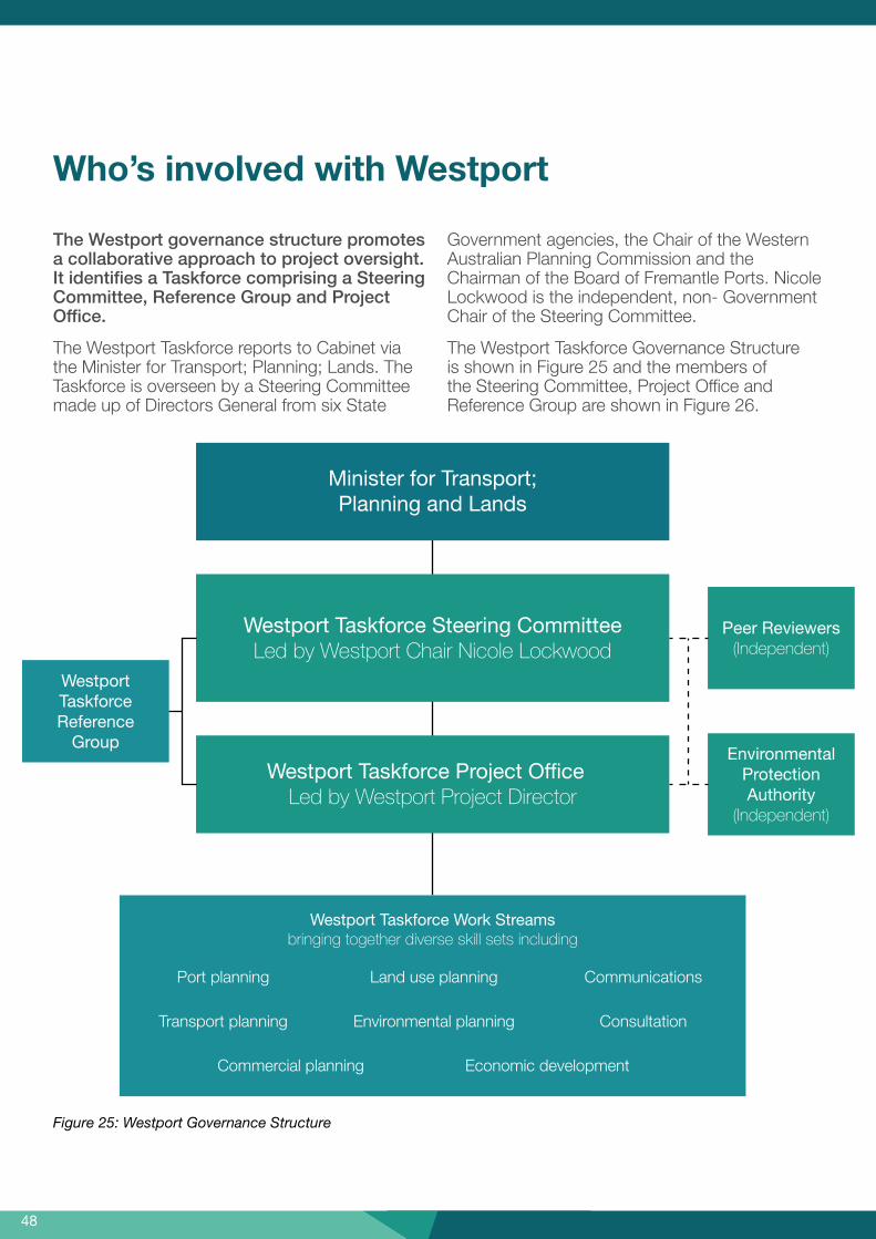
The Westport governance structure promotes a collaborative approach to project oversight. It identifies a Taskforce comprising a Steering Committee, Reference Group and Project Office.
The Westport Taskforce reports to Cabinet via the Minister for Transport; Planning; Lands. The Taskforce is overseen by a Steering Committee made up of Directors General from six State
Figure 25: Westport Governance Structure
Government agencies, the Chair of the Western Australian Planning Commission and the Chairman of the Board of Fremantle Ports. Nicole Lockwood is the independent, non- Government Chair of the Steering Committee.
The Westport Taskforce Governance Structure is shown in Figure 25 and the members of the Steering Committee, Project Office and Reference Group are shown in Figure 26.
Who’s involved with Westport
Peer Reviewers (Independent)
Westport Taskforce Reference
GroupEnvironmental
Protection Authority
(Independent)
Minister for Transport; Planning and Lands
Westport Taskforce Steering CommitteeLed by Westport Chair Nicole Lockwood
Westport Taskforce Project OfficeLed by Westport Project Director
Westport Taskforce Work Streamsbringing together diverse skill sets including
Environmental planning Consultation
Commercial planning Economic development
Port planning Land use planning Communications
Transport planning
4948
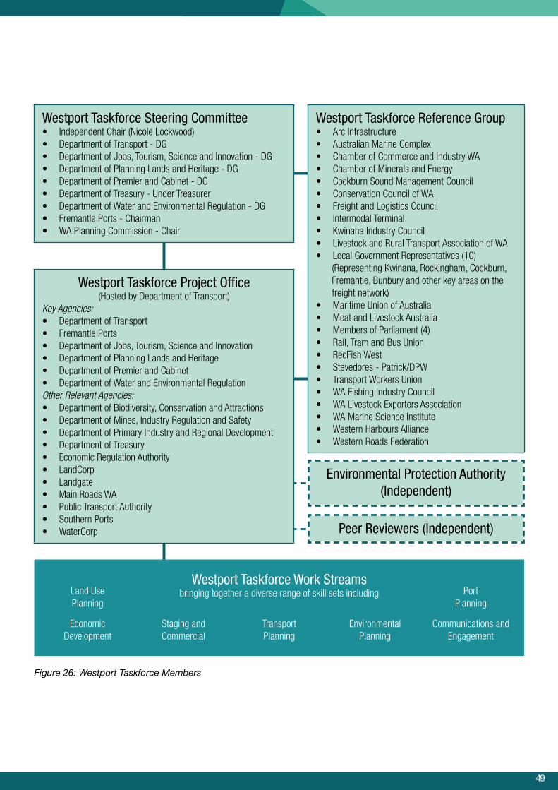
Westport Taskforce Steering Committee• Independent Chair (Nicole Lockwood)• Department of Transport - DG• Department of Jobs, Tourism, Science and Innovation - DG• Department of Planning Lands and Heritage - DG• Department of Premier and Cabinet - DG• Department of Treasury - Under Treasurer• Department of Water and Environmental Regulation - DG• Fremantle Ports - Chairman• WA Planning Commission - Chair
Environmental Protection Authority(Independent)
Peer Reviewers (Independent)
Westport Taskforce Project Office(Hosted by Department of Transport)
Key Agencies:• Department of Transport• Fremantle Ports• Department of Jobs, Tourism, Science and Innovation• Department of Planning Lands and Heritage• Department of Premier and Cabinet• Department of Water and Environmental RegulationOther Relevant Agencies:• Department of Biodiversity, Conservation and Attractions• Department of Mines, Industry Regulation and Safety• Department of Primary Industry and Regional Development• Department of Treasury• Economic Regulation Authority• LandCorp• Landgate• Main Roads WA• Public Transport Authority• Southern Ports• WaterCorp
Westport Taskforce Reference Group• Arc Infrastructure• Australian Marine Complex• Chamber of Commerce and Industry WA• Chamber of Minerals and Energy• Cockburn Sound Management Council• Conservation Council of WA• Freight and Logistics Council• Intermodal Terminal• Kwinana Industry Council• Livestock and Rural Transport Association of WA• Local Government Representatives (10)
(Representing Kwinana, Rockingham, Cockburn, Fremantle, Bunbury and other key areas on the freight network)
• Maritime Union of Australia• Meat and Livestock Australia• Members of Parliament (4)• Rail, Tram and Bus Union• RecFish West• Stevedores - Patrick/DPW• Transport Workers Union• WA Fishing Industry Council• WA Livestock Exporters Association• WA Marine Science Institute• Western Harbours Alliance• Western Roads Federation
Westport Taskforce Work Streamsbringing together a diverse range of skill sets includingLand Use
Planning
Economic Development
Staging andCommercial
TransportPlanning
EnvironmentalPlanning
Communications andEngagement
PortPlanning
Figure 26: Westport Taskforce Members

5150
In this initial phase of engagement we are seeking your feedback on the process for developing the Westport Strategy.
Specifically, we would like you to consider the following:
• Do you support the proposed approach? If not, why?
• Have we missed any key issues?
• Do you have any information to help us build our evidence base?
• Can you or your organisation contribute toWestport? If so, please describe how and send your contact details to [email protected]
The public comment period for feedback on this discussion paper closes at 5pm on 31 January 2018.
To provide feedback or subscribe to Westport updates visit:
https://www.transport.wa.gov.au/projects/westport-port-and-environs-strategy.asp
Following the public comment period, feedback will be reviewed and collated.
A consultation summary Westport: What you have told us will be made available on the Westport website by the end of February. This will summarise the comments received and outline the updated Westport methodology (Figure 27).
How you can help us
November 2017 February 2018December 2017 - January 2018
Preparing for a Strategy
Project Control GroupTo review and provide
feedback on the Preparing for a Strategy Paper
Preparing fora Strategy drafting
Steering Committee meeting
Meeting on 6 December to review and approve the
Preparing for a Strategy Paper
Approvalfrom
SteeringCommittee
Reference Group ForumForum on 11 December Preparing for a Strategy
discussion paper presented to group
Presented to Reference
Group
The Public Consultation period
Open until 31 January 2018
Consultation periodcloses
Westport TeamRelease a consultation summary
with the feedback provided during the consultation period
by the end of February
Consultation report
Figure 27: Westport: Preparing for the Strategy Timeline

5150
While the Westport methodology is being confirmed, the Westport Project Office will be gathering previous reports, collating data sources and assessing what information is relevant, what is still current, and where there may be information gaps.
Some of the information gaps may be filled by reports and information identified through the Westport: Preparing for the Strategy public consultation process. Other gaps may need to befilled with new investigations.
Multi-disciplinary Work Streams will be established from Taskforce members to investigate the questions identified in the Westport methodology. The collated information will serve as a starting point to answer the key questions and will be supplemented with additional research as required.
During this phase regular updates will be provided on the Westport website.
A compendium report, showing the evidence gathered to answer each question will be released around August 2018. This report will also include the criteria to assess the port options. The criteria will be released for public comment so that everyone understands the rationale for assessing the various port options.
Westport: How we will assess the options will be published around October 2018 and this will describe the final criteria that will be used to assess the port options.
Between October 2018 and June 2019, the various port options will be assessed using the criteria to identify the preferred option. The results of the assessment will be collated into the Westport: Port and Environs Strategy – Consultation Draft and released for public comment.
Comments will be collated and the revised document released as the final Westport: Port and Environs Strategy in September 2019 (Figure 28).
What happens next?
Figure 28: Westport milestones
Nov - 17
Jan - 18
Apr - 18
Jul - 18
Oct- 18
Jan - 19
Apr - 19
Jul - 19
Oct - 19
Dec - 19
Dec - 17Preparing for a Strategy
Feb - 18What you have told us
Oct - 18How we will assess
the options (show how feedback on
assessment criteria will be addressed)
Sep - 19Port and Environs
Strategy Final Report
Aug - 18What we have found so
far (Compendium of answers to questions)
Jun - 19Port and Environs Strategy
Consultation Draft

Disclaimer: The information contained in this publication is provided in good faith and believed to be accurate at time of publication. The State shall in no way be liable for any loss sustained or incurred by anyone relying on the information.
December 2017