Embed Size (px)
Citation preview
91
WETLAND ECOLOGY AND CONSERVATION
Ecology and Inventory

92
93
An analysis of wetland inventory andinformation sources1
CM Finlayson, NC Davidson2,3, AG Spiers & NJ Stevenson2,4
1 IntroductionOver the past few decades many wetland scientists and managers have called for the collectionof further information for wetland conservation and management. Knowledge of the location,distribution and character of wetlands, their values and uses, is required at a variety ofgeographical scales, ranging from local to national and international (Dugan 1990, Finlayson1996a). Despite the compilation of such information many basic features of wetlands around theworld have apparently not been recorded (Finlayson & van der Valk 1995).
Furthermore, the scattered nature of the information that is available has prevented effectiveassessment of the size and distribution of the global wetland resource (Finlayson & van derValk 1995). Recognition of this situation by the Ramsar Convention on Wetlands led to the�Global review of wetlands resources and priorities for wetland inventory� (GRoWI), areview of the state of wetland inventory and the extent to which it can yield information onthe size, distribution and status of the global wetland resource (Finlayson & Spiers 1999,Finlayson et al 1999). The review was linked with analyses undertaken in two internationalworkshops. One addressed practical issues for wetland inventory, assessment andmonitoring (Finlayson et al 2001a); the other examined information management systemsfor assessing the conservation and status of wetlands (Davidson 1999). A summary of thereview and these analyses is given below.
2 Definitions and concepts of wetland inventoryThe global review of wetland inventory used an array of source material since an inventorywas considered to be simply a collation of material on wetlands, specifically their locationand size, possibly augmented with further information on their biophysical features andmanagement. This broad interpretation of inventory was adopted after considering the reportby Finlayson (1996a) who, after differentiating between a wetland inventory and a wetlanddirectory noted that� in reality the terms were often used loosely and interchangeably.
However, due to inconsistency in usage it was necessary to differentiate between inventory,assessment and monitoring of wetlands. The definitions proposed by Finlayson et al (2001b)were adopted.
1 More detailed discussion of this research is provided in Finlayson CM & Spiers AG (eds) 1999. Global reviewof wetland resources and priorities for wetland inventory. Supervising Scientist Report 144, SupervisingScientist, Canberra. & in Finlayson CM, Davidson NC, Spiers AG & Stevenson NJ 1999. Global wetlandinventory � status and priorities. Marine and Freshwater Research 50, 717�727.
2 Wetlands International, Wageningen, The Netherlands.3 Present address: Ramsar Convention Bureau, Gland, Switzerland.4 Present address: Ecoscope, Cambridge, United Kingdom.

94
Wetland inventory � the collection and/or collation of core information for wetlandmanagement, including the provision of an information base for specific assessment andmonitoring activities.
Wetland assessment � the identification of the status of, and threats to, wetlands as a basisfor the collection of more specific information through monitoring activities.
Wetland monitoring � the collection of specific information for management purposes inresponse to hypotheses derived from assessment activities. (This definition is taken from thatdeveloped for the Ramsar Convention and Mediterranean wetland program; Finlayson1996b,c.)
Thus, inventory, assessment and monitoring are separate processes, although inexorably linked.This position was also accepted by Costa et al (1996) when developing a protocol for wetlandinventory in the Mediterranean. Finlayson et al (1999) and Costa et al (1996) also accepted thatwhilst inventory provided a basis for monitoring it was not itself a monitoring tool.
3 Information sources, collation and analysisThe information reviewed here is derived chiefly from the international projects noted aboveand complemented by information contained in draft protocols for an Australian nationalwetland inventory (Finlayson 1999), so providing a synthesis of the most up-to-date analysesavailable of inventory information for the world�s wetlands. The most comprehensive of theinternational projects was the global review of wetland resources undertaken on behalf of theRamsar Convention on Wetlands (Finlayson & Spiers 1999). This comprised separate reportsfor each of the Ramsar Convention�s then seven geo-political regions (with a Middle Eastanalysis reported separately from the remainder of the Asia region), a separate report oncontinental- and international-scale inventory, and a summary report covering results,conclusions and recommendations at the global scale.
The outcomes from the global review of wetland inventory were combined with informationfrom the other projects to present an overview of the current status of wetland inventoryaround the globe. The overview was then used as a basis to outline and providerecommendations for standardised inventory methods, information management, and prioritydirections for improving further inventory.
4 Analysis of wetland inventory
Extent and coverage of wetland inventoryOf the 188 sources examined in detail only 18% were comprehensive wetland inventories;74% were partial inventories, chiefly in two categories - either inventories of importantwetlands only or inventories of particular wetland habitat types only; 9% were sources ofinformation containing wetland inventory but covering a broader scope than solely wetlands,e.g. national soil surveys. Further, only 7% of the 206 countries and territories for whichinventory information was sought have an adequate coverage of wetland inventoryinformation (although several other countries do have major inventory programs underway orplanned); 68% have only partial inventory coverage (important sites only and/or some habitattypes only) and 25% of countries and territories have little or no inventory coverage.
The inadequacy of many inventories was also shown. Inventory methodology was not describedin 18% of inventories. Only 30% of inventory sources defined the type of wetlands they

95
included, and for over one-third (34%) no definition could even be inferred. Further, only 52%of sources provided a statement of the objectives of the inventory, and of these only half wereundertaken specifically as baseline wetland inventory; and only 49% of sources provided areavalues per defined wetland type, although some others gave only overall wetland area (notdivided by type). 35% proved to be compilations or reviews of existing material (undertaking nonew data collection). There was variation in the extent to which inventories also providedinformation that is categorised as �assessment� under the above definitions: half (49%) providedwetland status information; but only 21% contained wetland loss or degradation information;and only 8% consistent information on wetland values and benefits.
Extent and distribution of wetlandsPrevious attempts to estimate the global extent and distribution of wetlands have been madethrough a variety of approaches. Such estimates vary considerably (5.6�9.7 million km2 , Spiers1999) and appear highly dependent on the type of source material and the definition of wetlandused. The broad Ramsar Convention definition of a wetland has been used in many nationalwetland inventories (41%). There are also many inventories that have been restricted to morespecific habitats, or exclude marine wetlands. However, in reviewing wetland inventoryinformation this presented less of a problem than those that did not include a clear definition ofthe range of habitats being considered.
Spiers (1999) summarised global estimates for different wetland types (natural freshwaterwetlands 5.7 million km2; rice paddy 1.3 million km2; mangroves 0.18 million km2; and coralreefs 0.3�0.6 million km2) and derived an estimate for these habitats only of 7.48�7.78million km2. As this estimate does not include a number of widespread and extensive wetlandtypes, notably saltmarshes and coastal flats, seagrass meadows, karsts and caves, andreservoirs, it implies a considerably larger global area than previous estimates. Combining theestimates from the analyses of the individual Ramsar regions also gives a much largerminimum area than previous estimates, ~12.76 million km2, for global wetlands (table 1).Since, as we have described above, these estimates are derived from extremely patchyinventory information, this implies that the global wetland area is considerably larger.However, given the patchiness of inventory these estimates must be treated as preliminaryminimum estimates and indicative only.
Table 1 Regional minimum estimates of wetland area (from Finlayson et al 1999)
Region Area (million km2)
Africa 1.21
Asia 2.04
Eastern Europe 2.29
Western Europe 0.29
Neotropics 4.15
North America 2.42
Oceania 0.36
It is not possible to make an objective assessment of the various estimates given becausemany inventories merely repeat previously gathered information and/or do not clearlydescribe the accuracy and reliability of the data (Finlayson et al 1999). For example, fewinventories have been regularly updated.
96
5 Standardisation of inventory approachesThe above analyses illustrate the inadequate standardisation of inventory techniques,including the means of recording and reporting the basic information that is necessary fordetermining, with confidence, the status of wetlands worldwide (Finlayson et al 1999). Manyinventories lack basic information, notably the objective or purpose of the inventory, thewetland definition and classification system, the method(s) of data collection, source data forstatistics of wetland area and wetland loss, name and affiliation of the compiler for individualsite data, etc.
The development of a standardised and flexible framework for wetland inventory will helpindividual countries to prepare national wetland inventories in a format compatible not onlywith their objectives but also with the inventory of neighbouring countries. This would greatlyimprove the capacity for comprehensive wetland inventory on a national and ultimately globalscale. Standardised approaches could be derived from existing models, notably those used inthe Mediterranean (Costa et al 1996) and the United States (Wilen & Bates 1995). Theseapproaches have been successfully adapted for use in other countries and could provide abasis for a standardised framework and wetland inventory database (Finlayson et al 2001b).
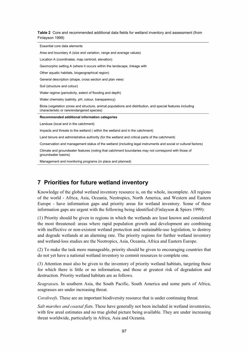
Finlayson et al (1999) also recommended the development of a hierarchical protocol to assistcountries in undertaking their inventories cost-effectively through the use of a basic data set todescribe the wetland. This should include the location and area and the basic features of thewetland that provide values and benefits to humans. This could include general indicators ordescriptors of the water regime, water quality and biota. Adoption of standardised wetlandclassification systems would greatly assist in comparisons between sites and regions andprovide a basis for management decisions that may lead to the collection of more specificinformation on threats, values and benefits, land tenure and management, and monitoring.Thus, it was further recommended that sufficient information (core data fields) should bederived to enable the major wetland habitats (at least) to be delineated and characterised atleast at one point in time (table 2). Additional data fields could be added if required forspecific purposes, such as wetland assessment, as recommended in draft protocols for anAustralian wetland inventory.
6 Information managementThe need to more effectively manage wetland inventory data has been outlined by Finlaysonet al (1999). Even the maintenance of a minimum core data set requires considerable care andthought, at least in terms of accessibility and storage and software compatibilities. Finlaysonet al (1999) stress that when inventory information is recorded it should be accompanied byclear records that describe when and how the information was collected and its accuracy andreliability. Such records were absent from many of the inventories reviewed in Finlayson &Spiers (1999).
As a minimum, a meta-database should be established and accessible. Regardless of the fieldsadopted it is essential that the meta-database follows an established data protocol and isreadily accessible. The need to immediately develop a standard, versatile meta-database isincreasingly widely recognised.
97
Table 2 Core and recommended additional data fields for wetland inventory and assessment (fromFinlayson 1999)
Essential core data elements
Area and boundary A (size and variation, range and average values)
Location A (coordinates, map centroid, elevation)
Geomorphic setting A (where it occurs within the landscape, linkage with
Other aquatic habitats, biogeographical region)
General description (shape, cross section and plan view)
Soil (structure and colour)
Water regime (periodicity, extent of flooding and depth)
Water chemistry (salinity, pH, colour, transparency)
Biota (vegetation zones and structure, animal populations and distribution, and special features includingcharacteristic or rare/endangered species)
Recommended additional information categories
Landuse (local and in the catchment)
Impacts and threats to the wetland ( within the wetland and in the catchment)
Land tenure and administrative authority (for the wetland and critical parts of the catchment)
Conservation and management status of the wetland (including legal instruments and social or cultural factors)
Climate and groundwater features (noting that catchment boundaries may not correspond with those ofgroundwater basins)
Management and monitoring programs (in place and planned)
7 Priorities for future wetland inventoryKnowledge of the global wetland inventory resource is, on the whole, incomplete. All regionsof the world - Africa, Asia, Oceania, Neotropics, North America, and Western and EasternEurope - have information gaps and priority areas for wetland inventory. Some of theseinformation gaps are urgent with the following being identified (Finlayson & Spiers 1999):
(1) Priority should be given to regions in which the wetlands are least known and consideredthe most threatened: areas where rapid population growth and development are combiningwith ineffective or non-existent wetland protection and sustainable-use legislation, to destroyand degrade wetlands at an alarming rate. The priority regions for further wetland inventoryand wetland-loss studies are the Neotropics, Asia, Oceania, Africa and Eastern Europe.
(2) To make the task more manageable, priority should be given to encouraging countries thatdo not yet have a national wetland inventory to commit resources to complete one.
(3) Attention must also be given to the inventory of priority wetland habitats, targeting thosefor which there is little or no information, and those at greatest risk of degradation anddestruction. Priority wetland habitats are as follows.
Seagrasses. In southern Asia, the South Pacific, South America and some parts of Africa,seagrasses are under increasing threat.
Coralreefs. These are an important biodiversity resource that is under continuing threat.
Salt marshes and coastal flats. These have generally not been included in wetland inventories,with few areal estimates and no true global picture being available. They are under increasingthreat worldwide, particularly in Africa, Asia and Oceania.
98
Mangroves. Mangroves are better mapped than other coastal and marine wetlands, but seriousinconsistencies exist and more comprehensive inventory is required. This should be used tobetter determine the mangrove loss that is proceeding at an alarming rate in many parts ofAfrica, south-east Asia and Oceania.
Arid-zone wetlands. These are poorly mapped but increasingly important in the light ofescalating population pressures and water demand.
Peatlands. These are well mapped in comparison with other wetland habitats. However, theyare threatened further in Europe, Asia and North America in particular, despite theirimportance as a global carbon sink and economic resource, and are poorly known in tropicalregions.
Rivers and streams. Rivers and streams are seriously threatened in many regions of the world.
Artificial wetlands. These are increasingly important, with reservoirs, dams, salinas, paddy,and aquaculture ponds being important in many regions, notably Asia, Africa and theNeotropics.
(4) Steps should be taken to develop communciation between wetland users at all levels, fromlocal to global, to ensure that the large amount of work required to establish, update or extendwetland inventory occurs. This is likely to require national action and a genuine will toidentify key processes for targeted improvement.
(5) Co-operation between countries and agencies, with the common aim of improving wetlandinventory for all wetland habitats, particularly those most threatened, should be enhanced.
(6) When undertaking further wetland inventory every effort should be made to link this withother national and international initiatives, such as the identification and delineation of furthersites of international importance.
8 RecommendationsEight priorities for action were recommended to the Ramsar Convention and accepted by itsContracting Parties in May 1999 (Ramsar Resolution VII.20).
(1) All countries lacking a national wetland inventory should undertake one, using anapproach that is comparable with other wetland inventories and for which the RamsarConvention should provide guidance.
(2) Quantitative studies of wetland loss and degradation are urgently required for much ofAsia, Africa, South America, the Pacific Islands and Australia.
(3) Further inventory should focus on a basic data set describing the location and size of eachwetland and its major biophysical features, including variations in area and the water regime.
(4) After acquisition of the basic data, further information should be collected with anemphasis on the management of threats to wetlands and uses of wetlands, land tenure andmanagement regimes, and values and benefits of wetlands. Source(s) of information should beclearly recorded along with comments on its accuracy and availability.
(5) Each inventory should include a clear statement of its purpose and the range ofinformation that has been collated or collected, the habitats covered and the date theinformation was obtained or updated.
(6) The Ramsar Convention should support the development and dissemination of models forimproved globally applicable wetland inventory. These should be derived from existing
99
models and incorporate habitat classifications, and information collation and storageprotocols.
(7) The Ramsar Convention should support development of a central repository for bothhardcopy and electronic inventories. The meta-data that describe the inventories should bepublished on the World Wide Web for greater accessibility.
(8) Further support is required for completion of the global review of wetland resources andpriorities for wetland inventory; and to develop procedures for regular updating andpublishing of inventory information on the World Wide Web.
9 Further developmentsThe analyses reported here has led to the development of a �Framework for wetlandsinventory� for the Ramsar Convention, which will be considered for adoption at Ramsar�s 8th
meeting of the Conference of the Parties (COP8) in November 2002. The Frameworkprovides a 13-step procedure for designing a wetland inventory, stressing that the precisenature of inventory chosen will depend on its purpose and objectives, geographical scale, andavailable resources. So as to assist in such choices, the Framework provides information onexisting proven inventory methods, options for wetland classifications, a core recommendeddataset, and an approach to identifying appropriate use of remote sensing datasets.
AcknowledgmentsA large part of this work was undertaken by a team drawn from Wetlands International andthe Environmental Research Institute of the Supervising Scientist (eriss), Australia, undercontract to the Bureau of the Ramsar Convention on Wetlands, and with financial supportfrom the United Kingdom and Netherlands Governments.
ReferencesCosta LT, Farinha JC, Hecker N & Tomas Vives P (eds) 1996. Mediterranean wetland
inventory: A reference manual. MedWet, Institutoda Conservação da Natureza, WetlandsInternational Publication vol 1, Lisbon.
Davidson NC 1999. Wetlands and biodiversity. Creation of global assessment tools forconservation, status, needs and priorities. (BCIS/NORAD wetland pilot project) Phase 1progress report, February, Wetland International, Wageningen, The Netherlands.
Dugan PJ (ed) 1990. Wetland conservation: A review of current issues and required action.IUCN, Gland, Switzerland.
Finlayson CM 1996a. Information required for wetland management in the South Pacific. InWetland conservation in the Pacific Islands region, ed R Jaensch, Proceedings of theRegional Workshop on Wetland Protection and Sustainable Use in Oceania, PortMoresby, Papua New Guinea, 6�10 June 1994, Wetlands International-Asia PacificPublication no 118, Canberra, 185�201.
Finlayson CM 1996b. The Montreux Record: A mechanism for supporting the wise use ofwetlands. In Proceedings of the 6th Meeting of the Conference of the Contracting Parties,Technical Sessions: Reports and Presentations, Technical Sessions B & D, RamsarConvention Bureau, Gland, Switzerland, 32�8.
100
Finlayson CM 1996c. Framework for designing a monitoring program. In MonitoringMediterranean wetlands: A methodological guide, ed P Tomas Vives, WetlandsInternational, Slimbridge, UK, & ICN, Lisbon, 25�34.
Finlayson CM 1999. Protocols for an Australian national wetland inventory. In Techniquesfor enhanced wetland inventory and monitoring, eds Finlayson CM & Spiers AG,Supervising Scientist Report 147, Supervising Scientist, Canberra, 119�145.
Finlayson CM & Spiers AG (eds) 1999. Global review of wetland resources and priorities forwetland inventory. Supervising Scientist Report 144, Supervising Scientist, Canberra.(also available on CD)
Finlayson CM & van der Valk AG 1995. Wetland classification and inventory: A summary.In Classification and inventory of the worlds wetlands, eds CM Finlayson & AG van derValk, Advances in Vegetation Science 16, Kluwer Academic Press, Dordrecht,Netherlands, 185�92.
Finlayson CM, Davidson NC, Spiers AG & Stevenson NJ 1999. Global wetland inventory �status and priorities. Marine and Freshwater Research 50, 717�727.
Finlayson CM, Davidson NC & Stevenson NJ (eds) 2001. Wetland inventory, assessment andmonitoring: Practical techniques and identification of major issues. Proceedings ofWorkshop 4, 2nd International Conference on Wetlands and Development, Dakar,Senegal, 8�14 November 1998, Supervising Scientist Report 161, Supervising Scientist,Darwin.
Finlayson CM, Davidson NC & Stevenson NJ 2001b. Wetland inventory, assessment andmonitoring � practical techniques and identification of major issues: Summary. InWetland inventory, assessment and monitoring: Practical techniques and identification ofmajor issues, eds Finlayson CM, Davidson NC & Stevenson NJ, Proceedings ofWorkshop 4, 2nd International Conference on Wetlands and Development, Dakar,Senegal, 8�14 November 1998, Supervising Scientist Report 161, Supervising Scientist,Darwin, 130�136.
Spiers AG 1999. Review of international/continental wetland resources. In Global review ofwetland resources and priorities for wetland inventory, eds Finlayson CM & Spiers AG,Supervising Scientist Report 144, Supervising Scientist, Canberra, 63�104. (also availableon CD)
Wilen BO & Bates MK 1995. The US Fish and Wildlife Service�s national wetland inventoryproject. In Classification and inventory of the world�s wetlands. eds CM Finlayson & AGvan der Valk, Advances in Vegetation Science 16, Kluwer Academic Publishers,Dordrecht, Netherlands, 153�69.
101
Climate change and sea level rise in theAlligator Rivers Region, northern Australia1
CM Finlayson, I Eliot2 & P Waterman3
IntroductionIn 1995 the Intergovernmental Panel on Climate Change (IPCC) released its SecondAssessment Report on the impacts, adaptations and mitigation of climate change withconfirmed and dire projections about future scenario (IPCC 1995). (The Third AssessmentReport was released in 2001 and confirmed such projections (IPCC 2001)). These reportsnoted the level of uncertainty with the scientific projections and the possible outcomes forboth ecological and social systems. The assessments covered vulnerability to climate changeof aquatic ecosystems and to water supply as a specific and important issue.
Coastal wetlands are expected to be highly vulnerable and susceptible to changes in theclimate and sea level (IPCC 1995). Changes in temperature and rainfall, sea level rise, andstorm surges could result in the erosion of shores and associated habitat, increased salinity ofestuaries and freshwater aquifers, altered tidal ranges in rivers and bays, changes in sedimentand nutrient transport and increased coastal flooding. Some coastal ecosystems are atparticular risk, including saltwater marshes, mangroves and river deltas as well as non-tidalwetlands (IPCC 1995). The extent of this change will be influenced by the sensitivity,adaptability and vulnerability of the individual ecosystems and locations.
With this background we examined in 1996 the vulnerability of the large and valuedfreshwater ecosystems of the Alligator Rivers Region which includes Kakadu National Park,northern Australia, to determine if they were at risk from climate change and sea level rise(Bayliss et al 1998, Eliot et al 1999).
Climate change scenarioThe major source of information for the prediction of climate change for this assessment wasprovided by Wasson (1992) and CSIRO (1994). Their projections are summarised in table 1.Scenarios for sea level rise were based on analyses adopted by the CSIRO (1994). Globalprojections of sea level rise range from 25�80 cm by the year 2100, with the most likelyestimate being a rise of 50 cm. By the year 2030 sea level is expected to have risen anestimated 8�30 cm. The estimates require adjustment to allow for regional and site specificconditions to determine the relative sea level change at that place. Specific estimates are notcurrently available for Kakadu National Park or the wider Alligator Rivers Region.
1 This paper is drawn from work published in SSR123: Bayliss B, Brennan K, Eliot I, Finlayson CM, Hall R,House T, Pidgeon R, Walden D & Waterman P 1997. Vulnerability assessment of predicted climate change andsea level rise in the Alligator Rivers Region, Northern Territory Australia. Supervising Scientist Report 123,Supervising Scientist, Canberra. Sections of it also appear in Eliot I, Waterman P & Finlayson CM 1999.Monitoring and assessment of coastal change in Australia�s wet-dry tropics. Wetlands Ecology andManagement 7, 63�81.
2 Department of Geography, The University of Western Australia, Perth, Western Australia, Australia([email protected])
3 Environmental Management Services, Canberra, Australia ([email protected])
102
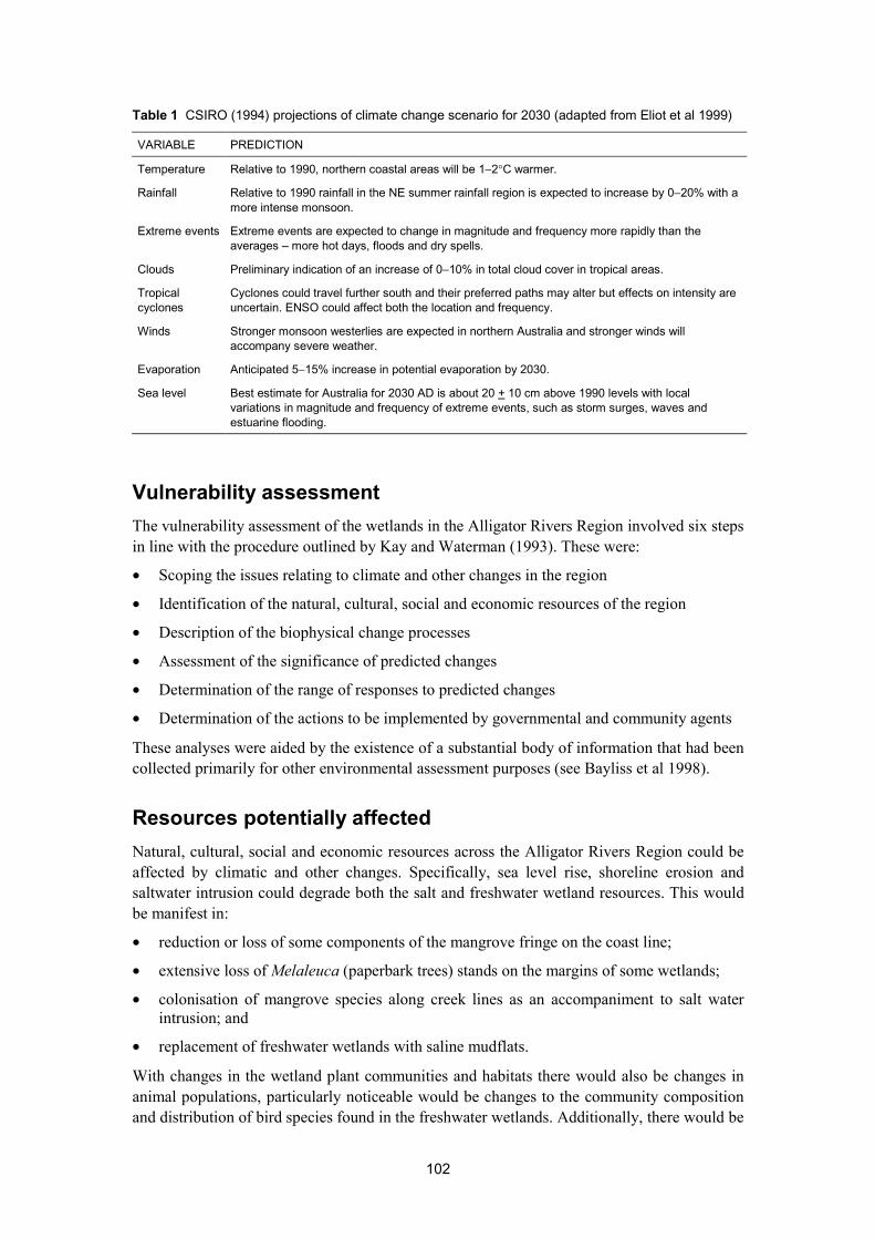
Table 1 CSIRO (1994) projections of climate change scenario for 2030 (adapted from Eliot et al 1999)
VARIABLE PREDICTION
Temperature Relative to 1990, northern coastal areas will be 1−2°C warmer.
Rainfall Relative to 1990 rainfall in the NE summer rainfall region is expected to increase by 0−20% with amore intense monsoon.
Extreme events Extreme events are expected to change in magnitude and frequency more rapidly than theaverages � more hot days, floods and dry spells.
Clouds Preliminary indication of an increase of 0−10% in total cloud cover in tropical areas.
Tropicalcyclones
Cyclones could travel further south and their preferred paths may alter but effects on intensity areuncertain. ENSO could affect both the location and frequency.
Winds Stronger monsoon westerlies are expected in northern Australia and stronger winds willaccompany severe weather.
Evaporation Anticipated 5−15% increase in potential evaporation by 2030.
Sea level Best estimate for Australia for 2030 AD is about 20 + 10 cm above 1990 levels with localvariations in magnitude and frequency of extreme events, such as storm surges, waves andestuarine flooding.
Vulnerability assessmentThe vulnerability assessment of the wetlands in the Alligator Rivers Region involved six stepsin line with the procedure outlined by Kay and Waterman (1993). These were:
• Scoping the issues relating to climate and other changes in the region
• Identification of the natural, cultural, social and economic resources of the region
• Description of the biophysical change processes
• Assessment of the significance of predicted changes
• Determination of the range of responses to predicted changes
• Determination of the actions to be implemented by governmental and community agents
These analyses were aided by the existence of a substantial body of information that had beencollected primarily for other environmental assessment purposes (see Bayliss et al 1998).
Resources potentially affectedNatural, cultural, social and economic resources across the Alligator Rivers Region could beaffected by climatic and other changes. Specifically, sea level rise, shoreline erosion andsaltwater intrusion could degrade both the salt and freshwater wetland resources. This wouldbe manifest in:
• reduction or loss of some components of the mangrove fringe on the coast line;
• extensive loss of Melaleuca (paperbark trees) stands on the margins of some wetlands;
• colonisation of mangrove species along creek lines as an accompaniment to salt waterintrusion; and
• replacement of freshwater wetlands with saline mudflats.
With changes in the wetland plant communities and habitats there would also be changes inanimal populations, particularly noticeable would be changes to the community compositionand distribution of bird species found in the freshwater wetlands. Additionally, there would be

103
changes in morphology of the streams and billabongs and in the composition of the fish andother aquatic species. However, detailed analyses of habitat-species interactions have notbeen done. Changes in the natural vegetation and faunal resources may have cultural, socialand economic consequences for the Aboriginal and non-Aboriginal people living in or visitingthe area. The cultural resources have both social and economic resource values as they relateto the plants and animals used by the local Aboriginal people.
The cultural, social and economic resources that could be affected by accelerated changeshould be viewed as indicative of the breadth of factors to be considered, rather thanexhaustive. Nonetheless, it serves to indicate the extent of possible changes to the resources ofthe park and the wider region.
Significance of potential changeThere is a very substantial body of information describing geologic and especially, recenthistoric changes to the coast and wetlands of the region (see summary in Bayliss et al 1998).Oceanographic processes in the nearby marine ecosystems contribute to many of the changesand are manifested by high rates of shoreline erosion, changing tidal regimes within the riversystems and contribution to saltwater intrusion into freshwater ecosystems. Changes resultingfrom these processes are seen in reduction of the fringing mangroves along the shoreline,expansion of the samphire and saltflat areas, colonisation of mangroves along estuarine leveebanks, and the headward erosion of tidal creeks. However, the significance of such changehas not been fully assessed.
Ecologic processes affected by environmental change include the expansion and contractionof plant communities with consequent effects on animal habitats. Again, insufficientknowledge of the interaction between wetland plant communities and changes in hydrologicaland depositional conditions makes prediction of the significance of long-term effects difficult.Wetland plant communities are viewed as being widespread in the region and highly dynamicin terms of variability in species composition, structure of the community and geographicspatial extent. The plant species are widespread at pan-regional and regional scales and nocommunities or individual species of rare or endangered species have been recorded.Similarly, animal species are widespread and no rare and endangered species are known fromareas that could be affected by environmental change.
Pastoralists farming lands adjacent to the region have registered concerns over increasingencroachment of saline waters into freshwater wetlands that are used for seasonal pastures(Woodroffe & Mulrennan 1993). The potential loss of existing economic activities has beenjudged as significant given the attention directed towards remedial measures (Applegate 1999).
Management of a changing environmentSix broad environmental management issues were identified through the issue scopingprocess used for the vulnerability assessment. Many of the issues are common to the coastalmargins of the Australian wet-dry tropics in general and underlie the possible managementresponses required to address the expected extent of ecological change in the wetlands. Theseissues and their implications are described below.
1 Perceptions and valuesThere has been no systematic examination of perceptions and values with respect tomanagement of the region. However, societal perceptions and values manifest in the level of
104
awareness of the possible effects of climatic and associated changes, as well as in attitudesheld with regard to the hazards and threats to the environment resulting from climate change.Raising awareness of the implications of climate change is an important first step in changinggovernmental and community perceptions of the implications of climate change.
2 Hazard and riskNatural hazards of the region include extreme weather events � tropical cyclones, monsoonaldepressions, heavy rainfall, extended Wet seasons, excessively high temperatures andprolonged droughts; flooding, channel avulsion and bank erosion; inundation of coastal plainsby storm surge; and coastal erosion, shoreline retreat, chenier migration and saltwaterintrusion. Questions of responsibility and accountability may need to be addressed whenchanges due to particular hazards disrupt orderly use of coastal resources for habitation,industry and commerce, recreation and conservation.
3 GovernanceGovernance in the region and neighbouring catchments is currently not geared to deal withenvironmental change of the type and magnitude that is currently occurring. Issues are dealtwith on a sectoral basis rather than in an integrated, intergovernmental and cross-sectoralmanner (Finlayson et al 1998). However, environmental change is manifested across thebiophysical region irrespective of jurisdictional boundaries. Governmental structures andcommunity-based management mechanisms need to provide a consistent and appropriateresponse for system management, rather than simply addressing problems at a sectoral level.
4 Strategic managementStrategic management has two interrelated components, regional development and resourceconservation. Regional development has strong economic connotations and raises questionsabout the best use of wetland areas. For example, the areas to the west of the Park areconsidered as important areas for seasonal pastures and measures have been proposed toprevent saltwater intrusion (Applegate 1999). In contrast, representatives from the fishingindustry consider that the wetlands need to be retained as natural systems that supportrecruitment of commercial fish species. There is clearly a need for the broad community toresolve such conflict within the context of a regional development strategy that encompassesadequate conservation of resources.
5 Acquisition and custodianship of informationThe acquisition and custodianship of information has been recognised as a key issue withinKakadu National Park as it is likely to impinge on:
• the strategic management of the responses to climate and other environmental change;
• research and monitoring needed to document the processes of change; and
• evaluation of the effectiveness of any management measures taken.
Lack of appropriate data and information causes poor decision-making and contributes toinappropriate management of coastal resources. An investment must be made in data andinformation with the object of reducing uncertainty, improving decision making, enhancingmanagement capability and ensuring that unnecessary funds are not spent on ill conceived andpoorly researched projects. Bayliss et al (1998) provide a summary of the information collatedduring the vulnerability assessment, in particular that from the wetland habitats most likely to

105
be affected by climate change. This led to Eliot et al (2000) collating further data on thecoastal environment and placing this within a management context. Whilst a large amount ofdata and information is available it has not always been possible to readily access this or use itfor further assessment. Issues of data management have also been addressed and reported(Finlayson & Bayliss 1997, Eliot et al 2000).
6 Environmental research and monitoringOngoing environmental research and monitoring is required in the region to provide data andinformation for:
• further understanding of the processes and extent of environmental change;
• development of management strategies and action plans;
• implementing management prescriptions;
• auditing the effectiveness of management actions; and
• assessing performance of the overall management processes.
Research and monitoring should be broad in scope and include examination of social issues.The latter would include measures to raise the general level of awareness of natural variationin the environment of the region. Natural systems research is needed to document theprocesses of change and their effects on the biophysical environment. Such research willrequire a high level of innovation in order to integrate the cultural implications of change.
Requirements for managementAs with broader environmental management a number of general principles can be appliedwhen dealing with sea level rise. These include:
• avoid development in areas that are vulnerable to inundation;
• ensure that critical natural systems continue to function naturally; and
• protect human lives, essential properties and economic activities.
Though principles are applicable in the broader context of environmental change, theirinterpretation requires more detailed consideration of local factors and processes affectingenvironmental well being.
Institutional arrangements that are already in place for the region and adjacent wetlands(Finlayson et al 1998) may need to be developed to meet the governmental and communityrequirements for integrated management of the coastal wetlands. Current arrangements tendto focus on the specific issues confronting individual agencies or departments within aspecific sphere of government. The intra- and inter-governmental dimensions of the issuesidentified for the coastal wetlands require an innovative approach because of the scale of theproblems, and because they cross-jurisdictional boundaries.
ReferencesApplegate RJ 1999. Saltwater intrusion and the Mary River wetlands of the Northern
Territory. In An international perspective on wetland rehabilitation, ed W Streever,Kluwer Academic Publishers, Dordrecht, The Netherlands, 113�119.

106
Bayliss B, Brennan K, Eliot I, Finlayson CM, Hall R, House T, Pidgeon R, Walden D &Waterman P 1997. Vulnerability assessment of predicted climate change and sea levelrise in the Alligator Rivers Region, Northern Territory Australia. Supervising ScientistReport 123, Supervising Scientist, Canberra.
Eliot I, Waterman P & Finlayson CM 1999. Monitoring and assessment of coastal change inAustralia�s wet-dry tropics, Wetlands Ecology and Management 7, 63�81.
Eliot I, Saynor M, Eliot M & Finlayson CM 2000. Assessment and monitoring of coastalchange in the Alligator Rivers Region, northern Australia. Supervising Scientist Report157, Supervising Scientist, Darwin.
Finlayson CM & Bayliss B (eds) 1997. Data management systems for environmental researchin northern Australia: Proceedings of a workshop held in Jabiru, Northern Territory,22 July 1995. Supervising Scientist Report 124, Supervising Scientist, Canberra.
Finlayson CM, Thurtell L, Storrs MJ, Applegate R, Barrow P & Wellings P 1998. Localcommunities and wetland management in the Australian wet-dry tropics. In Wetlands in adry land: Understanding for management, ed WD Williams, Biodiversity Group,Environment Australia, Canberra, 299�311.
IPCC 1995. Climate change 1995: Impacts, adaptations and mitigation of climate change:Scientific-technical analyses. Intergovernmental Panel on Climate Change, CambridgeUniversity Press, Cambridge.
IPCC 2001. Climate change 2001: Impacts, adaptation, and vulnerability. IntergovernmentalPanel on Climate Change, Cambridge University Press, Cambridge.
Kay R & Waterman P 1993. Review of the applicability of the common methodology forassessment of the vulnerability to sea level rise to the Australian coastal zone. InProceedings of the IPCC Eastern Hemisphere Workshop on Vulnerability Assessment toSea Level Rise and Coastal Zone Management, eds R McClean & N Mimura, Tsukaba,Japan, 237�248.
Suppiah R, Hennessy K, Hirst T, Jones R, Katzey J, Pittock B, Walsh K, Whetton P &Wilson S 1998. Climate change under enhanced greenhouse conditions in northernAustralia. Final Report 1994�1997. CSIRO Division of Atmospheric Research,Aspendale, Australia.
Wasson RJ (ed) 1992. Modern sedimentation and late quaternary evolution of the MagelaCreek Plain. Research report 6, Supervising Scientist for the Alligator Rivers Region,AGPS, Canberra.
Woodroffe CD & Mulrennan ME 1993. Geomorphology of the lower Mary River plains,Northern Territory. Australian National University, North Australia Research Unit andthe Conservation Commission of the Northern Territory, Darwin NT.
107
A review of wetland conservation issues in theNorthern Territory1
MJ Storrs2 & CM Finlayson
1 IntroductionThe ecological character of wetlands of the Northern Territory (NT) has been described in ageneral sense and the major threats or management problems identified (Finlayson et al 1988,1991, Finlayson & von Oertzen 1993). These reviews and reports on specific localities alsoidentified major gaps in knowledge of basic ecological processes and threats to wetlands and,in the more isolated areas, even the character and extent of wetlands. Despite a general levelof knowledge the information base is not uniform. Whilst reasonable data/information existsfor some wetlands and/or threats to wetlands, a comprehensive inventory of all wetlands inthe NT is not available.
A comprehensive review of wetland conservation and management issues for wetlands in theNorthern Territory (Australia) was prepared by Storrs and Finlayson (1997) as a discussionpaper for the development of a wetland conservation strategy. (A strategy was finalised andpublished by the Parks and Wildlife Commission of the Northern Territory (2000)). Theconservation value of wetlands and the threats that they face were identified and describedwithin a framework of sustainable utilisation of resources and maintenance of biologicaldiversity. A summary of this paper is presented here.
2 Geographic settingThe NT lies between latitudes 11°S and 26°S an encompasses a large proportion of tropicalAustralia. The 1 347 x 106 km2 area of the NT is divided into three broad landforms: i) thetropical northern zone that contains large rivers with wide coastal plains with permanent andseasonal wetlands; ii) the central semi-arid zone of uncoordinated drainage that containsseasonal and intermittent wetlands; and iii) the southern lowland zone of coordinated drainagethat contains intermittent and episodic wetlands.
The NT comprises two broad climatic zones. In the north, the warm-hot wet seasoncommences late in the year (Nov-Dec) and lasts for 3−4 months. The remainder of the year iscooler and mostly dry. South-easterly trade winds and a high pressure belt dominate theclimate in the south. During the warm months (the temperate summer months) the south-easttrade winds are interrupted by intrusions of moist air from tropical low-pressure troughs to thenorth. Most of the annual rainfall comes from violent convectional thunderstorms. Overnightfrost can occur at sites in the south.
1 A more detailed discussion of this topic is found in Storrs MJ & Finlayson CM 1997. Overview of theconservation status of wetlands of the Northern Territory. Supervising Scientist Report 116, SupervisingScientist, Canberra.
2 Northern Land Council, PO Box 42921, Casuarina, NT 0811, Australia.

108
3 Current knowledge of wetland resourcesFor convenience of summarising the information on wetlands of the NT the geographic areahas been divided into three broad administrative regions � northern, central and southernregions. Given difficulties with systems used to classify wetlands a simplistic and interimclassification was adopted for this review (table 1). Storrs and Finlayson (1997) also providemaps that show the distribution of plants species generally associated with wetland habitats.
Table 1 A simplistic and interim classification system for wetlands of the Northern Territory. The generaloccurrence of wetland categories within the three broadly delineated regions of the NT is also shown.
Wetland categories Region of the NT
1 Coastal salt marshes Northern/Central region
2 Mangrove swamps Northern/Central region
3 Freshwater lakes and swamps Northern/Central/Southern region
4 Floodplains Northern region
5 Freshwater ponds Northern/Central/Southern region
6 Seasonal and intermittent saline lakes Southern region
It was not possible, based on current inventory information, to accurately depict the extent ofwetlands across the NT. Maps produced by Paijmans et al (1985) whilst not specificallydelineating discrete wetlands were used to illustrate a number of key points about thedistribution of wetlands in the NT that reflect the general landforms and climate:
• general low occurrence of permanent swamps and lakes;
• permanent and near permanent wetlands occur along the coast and in the northern area;
• episodic lakes and land subject to inundation are spread across the central and southernregions; and
• generally dry wetlands occur across most of the central and southern regions
Storrs and Finlayson (1997) list the many major datasets on wetland features held by NTgovernment agencies and used this along with past reviews of northern Australian wetlands todescribe the major known features of wetlands in the NT.
4 Conservation status of wetlandsGeneric comments on the conservation status of wetlands in the NT and the pressures thatthey face are described below. It is stressed that further assessment, monitoring and even auditof the conservation status of the wetland habitats and ecosystems is still needed.
Invasive plantsMajor weed species include Acacia nilotica (prickly acacia), Cenchrus ciliaris (buffel grass),Eichhornia crassipes (water hyacinth), Salvinia molesta (salvinia), Parkinsonia aculeata(parkinsonia), Prosopsis limensis (mesquite), Tamarix aphylla (athel pine), Brachiaria mutica(paragrass), Echinochloa polystachya (aleman grass), Hymenachne amplexicaulis (olivehymenachne) and Mimosa pigra (mimosa).
Paragrass and other pasture species such olive hymenachne, present a particularly difficultproblem given that pastoralists desire them while conservation and fisheries authorities are
109
concerned over their potential to alter the ecological character of wetlands. Paragrass is highlyinvasive and has spread across many wetlands in northern Australia, aided by deliberateplantings. The major weed species is undoubtedly mimosa which has spread across coastalfloodplains in an arc extending from the Moyle River in the west to the Arafura Swamps inArnhem Land (Harley 1992). It covers an estimated 80 000 ha. Research efforts have centredon finding suitable biological control agents with a number having been released. Integratedcontrol programs are also in place and incorporate biological control along with the use ofherbicides, mechanical removal (chaining), burning and revegetation.
Invasive animalsMajor invasive animals include Bubalus bubalis (Asian water buffalo), Sus scrofa (pig), Bufomarinus (cane toad), Equus caballus (horse) and Equus asinus (donkey), Camelus dromedarius(camels), and Oryctolagus cuniculus (rabbit). Prior to the 1980s feral Asian water buffaloproliferated on the coastal floodplains of the NT and were considered responsible for widescaledestruction of the native vegetation by direct grazing, trampling and wallowing, and indirectlyby destroying levee banks and contributing to premature drainage of freshwaters (Finlayson etal 1988). However, throughout the 1980s the feral herds to the west of Arnhem Land werealmost eradicated as part of a national program to prevent diseases being transferred to domesticstock. They still exist in large numbers in Arnhem Land.
Feral pigs are widespread and have caused widespread damage around the edges of wetlands.There is also evidence they have proliferated following the removal of the buffaloes from thefloodplains (Corbett 1995). Control of pigs is widely regarded as difficult in certain types ofterrain. Camels concentrate around salt lakes and clay pans in the southern region of the NTwhile horses and donkeys are prevalent in the southern and central regions. The extent of theirimpact on wetlands is unknown. The impact of grazing by rabbits severe in the southernregion and tapers off northwards. Excessive grazing can devastate the vegetative margins ofephemeral lakes and pools. Of increasing concern are the cane toads that have movedwestwards from Queensland into the NT. There is major concern and uncertainty about theeffect they will have on native fauna.
Fire and burning regimeFire is a conspicuous element of the landscape in the northern part of the NT and burningpatterns have changed considerably in recent decades. Andersen (1996) questions theemphases of some fire management regimes and along with other authors points out that theecological consequences of burning patterns are, on the whole, inadequately known. Roberts(1996) refers to the wealth of traditional Aboriginal knowledge on fire and burning regimes inrelation to food availability. In some landscapes there is a deliberate policy that attempts,amongst other objectives, to re-establish some semblance of traditional Aboriginal burning(Ryan et al 1995, Roberts 1996). Vast areas of the central and southern regions of the NT arealso burned on a regular basis, including many intermittently or episodically floodedwetlands.
OvergrazingSoil erosion, due largely to poor land management including overgrazing has resulted inextensive degradation of waterholes, stream banks and the riparian vegetation (Winter 1990).Heavily grazed wetland communities tend to converge floristically and introduced pasturespecies are known to replace the native grasses (Liddle & Sterling 1992). In addition to

110
changes in the vegetation changes in primary production also have an adverse effect onfisheries production in estuaries (Griffin 1996). Overall, however, little is known aboutchanges due to grazing.
Tourism and recreational activitiesThe environmental impact of tourism and recreational activities on wetlands has not on thewhole been specifically investigated. The notable exceptions are possibly the effect of boatsin specific locations, the pressure of recreational fishing on barramundi (Lates calcarifer)stocks, and the hunting of geese by non-Aborigines. However, the pressure from suchactivities needs to also consider infrastructure and associated disturbance. Anticipatedincreased tourism and extension of recreational activities is expected to increase pressure onwetlands. Hunting of geese by non-Aborigines has recently undergone increased regulationand has been subjected to intensive research and monitoring.
Pollution and contaminantsWater pollution, in particular that associated with mining has received a large amount ofattention. The former mining activities at Rum Jungle are the subject of extensiverehabilitation effort while the Ranger uranium mine is the subject of a strict testing andmonitoring regime (Humphrey et al 2000). Pesticides and fertilisers are used extensively inagricultural projects and for weed control on coastal wetlands, but little information isavailable on their impact on wetlands. Pollution from sunscreens, soaps and insect repellentsmay become a problem in small permanent waterholes frequented by tourists, as could fuelspillage from boats. Lead poisoning of waterfowl from ingested shotgun pellets is a problemat hunting reserves in the northern region (Whitehead & Tschirner 1991). Salinity is possiblythe major concern in the coastal freshwater wetlands (Jonauskas 1996). Bayliss et al (1997)consider that many of these wetlands are under threat from sea level rise in association withthe Greenhouse Effect.
Water regime and physical modificationWater regulation and physical modification of wetlands in the NT occur, but not to the sameextent as in eastern Australia. Small barrages and dams are being constructed, but at this stagethese are not considered to be excessively detrimental, although at times these issues have beenhotly debated (Julius 1996). The clearing of mangroves for port, industrial and/or residentialpurposes has also aroused controversy. The proposed development of irrigated agriculture hasraised concerns over water logging, sedimentation and discharges of polluted water.
5 Current uses of wetlandsThe NT Government has adopted a policy of multiple land use for wetland management andencourages different land uses in balance with conservation objectives. Current uses include:pastoralism, grazing and some horticulture, commercial fishing, tourism and recreation,especially amateur fishing, crocodile egg harvesting, commercial pig harvesting, safari stylebuffalo hunting, conservation and nature reservation, and traditional subsistence. Land usesare more intensive in the seasonally inundated and very productive wetlands near Darwin inthe northern coastal region than in the wetlands of the semi-arid and arid areas.
Pastoralism has been by far the most extensive land use in the NT. The wetland areas are themost nutrient rich and mesic areas and thereby produce the best forage for livestock.

111
However, there has been much debate on the efficacy of pastoral activities in the arid zone ofAustralia with periodic calls for the removal of grazing from at least some areas. Tourism andrecreation are increasingly important land uses based on natural and cultural values. Therecreational fishing industry is well established in the coastal wetlands with barramundi beingfavoured species (Julius 1996, Griffin 1996). Commercial fishing also occurs withbarramundi and mud crabs being targeted.
New commercial uses of wetlands are being developed, such as wildlife utilisation (eg gooseand crocodile egg collection), expanded tourism (eg hunting or photographic safaris orcultural and wildlife tours) agriculture and horticulture. Many of these activities are beinginvestigated on wetlands owned by Aboriginal people.
Major issuesBased on information collated in the review a number of generic strategic issues forsuccessful management of wetlands in the NT have been identified (Table 2). These havebeen expressed within the context of the specific objectives of the Conservation Stategy forthe NT (NT Government 1994).
Table 2 Strategic issues for wetland conservation in the NT
Conservationstrategy objective
Strategic issues for wetland conservation
Understanding Develop and maintain a comprehensive inventory database for all wetlands, includingprotocols to ensure it is updated at regular intervals
Characterise and quantify the importance of the physical and ecological interactions andlinkages that occur between wetlands
Characterise the processes that maintain the ecological character and values and quantifythe importance of ecological benefits of wetlands
Public awareness Develop community awareness of the extent, values and benefits of wetlands.
Protection andmanagement
Implement catchment-wide land use planning processes that encompass wetlands andensure the maintenance of their ecological character and values and benefits
Enhance the reservation and management of wetlands within a systematically developedprotected areas network that is representative of the diversity of wetland habitats, speciesand values and benefits
Instigate specific management arrangements for wetland conservation and sustainableutilisation regardless of land tenure
Enhance the level of control over and planning of grazing activities, especially in thecentral and southern regions
Monitoring Develop and implement monitoring programs that describes the ecological character ofwetlands to provide early warning of any potential adverse change.
Restoring Assess the extent of ecological degradation caused by specific pest species and developappropriate control measures based on rigorous risk assessment.
Undertake immediate control measures for effective management of salinisation and othereffects associated with climate change, especially in the northern region.
Undertake immediate control measures for effective management of grazing in allwetlands.
Reviewing Develop and implement a regular and systematic reporting process on the state ofwetlands.
In developing these strategies a large emphasis was placed on integrated land use andplanning policies. It is doubtful that these could be effectively developed and implementedwithout the adoption of an integrated and multi-sectoral approach to wetland management.
112
ReferencesAndersen AN 1996. Fire ecology and management. In Landscape and vegetation ecology of
the Kakadu region, Northern Australia, eds CM Finlayson & I von Oertzen, KluwerAcademic Publishers, Dordrecht, Netherlands, 179�195.
Bayliss B, Brennan K, Eliot I, Finlayson CM, Hall R, House T, Pidgeon R, Walden D &Waterman P 1997. Vulnerability assessment of predicted climate change and sea levelrise in the Alligator Rivers Region, Northern Territory Australia. Supervising ScientistReport 123, Supervising Scientist, Canberra.
Corbett LK 1995. Does dingo predation or buffalo competition regulate feral pig populationsin the Australian wet-dry tropics? An experimental study. Wildlife Research 22(1),65−74.
Finlayson CM, Bailey BJ, Freeland WJ & Fleming M 1988. Wetlands of the NorthernTerritory. In The conservation of Australian wetlands, eds AJ McComb & PS LakeSurrey Beatty and Sons, Sydney, 103−116.
Finlayson CM & von Oertzen I 1993. Wetlands of northern (tropical) Australia. In Wetlandsof the World 1: Inventory, ecology and management, eds DF Whigham, D Dykjova &S Hejny, Kluwer Academic Publishers, Dordrecht, Netherlands, 195−243.
Finlayson CM, Wilson B & Cowie ID 1991. Management of freshwater monsoonal wetlands:Conservation threats and issues. In Educating and management for wetland conservation,eds R Donohue & B Phillips, ANPWS, Canberra, 109−117.
Griffin RK 1996. Barramundi and the Mary River wetlands. In Making multiple landusework: Proceedings of the Wetlands Workshop, 6�7 December 1994, Darwin NT, ed PJonauskas, Department of Lands, Planning & the Environment, Palmerston NT, 45�49.
Harley KLS 1992. A guide to the management of Mimosa pigra. CSIRO, Canberra.
Humphrey, C.L., Thurtell, L., Pidgeon, R.W.J., van Dam, R.A. and Finlayson, C.M. 1999. Amodel for assessing the health of Kakadu�s streams. Australian Biologist 12, 33-42.
Jonauskas P (ed) 1996. Making multiple landuse work: Proceedings of the WetlandsWorkshop, 6�7 December 1994, Darwin NT, Department of Lands, Planning & theEnvironment, Palmerston NT.
Julius A 1996. What price the fish? In Making multiple landuse work: Proceedings of theWetlands Workshop, 6�7 December 1994, Darwin NT, ed P Jonauskas, Department ofLands, Planning & the Environment, Palmerston NT, 83�85.
Liddle DT & Sterling EA 1992. The integration of pastoralism and conservation on thecoastal wetlands of the Northern Territory. In Australian rangelands in a changingenvironment, Proceedings of the 7th Biennial Conference of the Australian RangelandSociety, Cobar, 129−136.
Northern Territory Government 1994. A conservation strategy for the Northern Territory.Government Printer of the Northern Territory, Darwin.
Paijmans K, Galloway RW, Faith DP, Fleming PM, Haantjens HA, Heyligers PC, et al 1985.Aspects of Australian wetlands. Division of Water and Land Resources, Paper 44,CSIRO, Australia.

113
Parks & Wildlife Commission of the Northern Territory 2000. A strategy for conservation ofthe biological diversity of wetlands in the Northern Territory of Australia. PWCNT,Darwin NT.
Roberts SJ 1996. Fire on the Gapalg (floodplain): Contemporary Aboriginal and otherburning patterns in Kakadu National Park, Northern Australia. In Fire in wetlands: Amanagement perspective. Proceedings of the Tall Timbers Fire Ecology Conference 19,Tall Timbers Research Station, Tallahassee, Florida.
Ryan P, Russell-Smith J & Durieu R 1995. Long term satellite monitoring of fire regimes inKakadu National Park, Northern Territory, Australia. In NARGIS 95: Proceedings of the2nd North Australian Remote Sensing and Geographic Information Systems Forum.Darwin, 18�20 July 1995, Supervising Scientist and the Australian Urban and RegionalInformation Systems Association Inc [Monograph No 11], AGPS, Camberra, 13−20.
Storrs MJ & Finlayson CM 1997. Overview of the conservation status of wetlands of theNorthern Territory. Supervising Scientist Report 116, Supervising Scientist, Canberra.
Whitehead PJ & Tschirner K 1991. Lead shot ingestion and lead poisoning of Magpie Geese(Anseranas semipalmata) foraging in a northern Australian hunting reserve. BiologicalConservation 58, 99−118.
Winter WH 1990. Australia's northern savannas: A time for change in managementphilosophy. Journal of Biogeography 17, 525−529.

114
Ecological character of two lagoonsin the lower Volta, Ghana1
CM Finlayson, C Gordon2, MJ Storrs3
& Y Ntiamoa-Baidu4,5
IntroductionThe socio-economic benefits of coastal lagoons in Ghana to the local people are very apparent� large quantities of fish and crabs are caught and traded; reeds and other plants are cut forthatch and for weaving mats; vegetables are grown in sandy garden beds irrigated by waterdrawn by hand from wells along the edges of the lagoons; and salt is extracted by bothintensive and extensive methods. In recent years, the immense conservation value of thelagoons has also been recognised (Ntiamoa-Baidu & Grieve 1987, Ntiamoa-Baidu 1991,1993, Piersma & Ntiamoa-Baidu 1995, Ntiamoa-Baidu et al 1998).
However, it became evident to authorites in Ghana, that the values and benefits provided bythe lagoons were under increasing threat from over-exploitation and degradation. Inresponse to this situation the Ghana Coastal Wetlands Management Project (CWMP) wasimplemented by the Ghana Wildlife Department (now Wildlife Division of the ForestryCommission) as part of the Ghana Environmental Resource Management Project, funded bythe Global Environmental Facility (GEF). The general aim of the CWMP was to create anenabling environment so as to manage five coastal wetland sites. The basic rationale for theproject was to maintain the ecological integrity of the lagoons and to enhance the benefitsderived from the wetlands by local communities.
In support of this aim we provide a description of the ecological character of the Keta andSongor lagoons in the Lower Volta region of Ghana (fig 1). The detailed informationcollected in this study is presented by Finlayson et al (2000). Here we provide information onthe climate, hydrology, chemistry, and the aquatic/wetland invertebrate fauna and the flora,and identify the major threats to the sustainable use of the lagoons.
MethodsSampling of each lagoon and the surrounding wetland vegetation was based on a stratifiedgrid drawn at intervals of 1' latitude and longitude (ie ≈ 1.8 x 1.8 km). The points ofintersection of the grid were used as the basis for selecting sites for sampling. Samples werealso collected from the Angor channel that connects the Keta lagoon with the Volta estuary.
1 More detailed discussion of this research is provided in Finlayson CM, Gordon C, Ntiamoa-Baidu Y, TumbultoJ & Storrs M 2000. The hydrobiology of Keta and Songor lagoons: Implications for coastal wetlandmanagement in Ghana. Supervising Scientist Report 152, Supervising Scientist, Darwin.
2 Volta Basin Research Project & Zoology Department, University of Ghana, Legon, Accra, Ghana.3 Formerly eriss (current address: Northern Land Council, PO Box 42921, Casuarina, NT 0811, Australia).4 Zoology Department, University of Ghana, Legon, Accra, Ghana; Ghana Wildlife Society, Accra, Ghana.5 present address: WWF International, Avenue du Mont-Blanc, 1196 Gland, Switzerland.

Figu
re 1
Loc
atio
n of
Ket
a an
d So
ngor
lago
ons
alon
gsid
e th
e lo
wer
Vol
ta R
iver
in e
aste
rn G
hana
115

116
For logistic convenience, the sampling strategy was divided into two components � oneaquatic and the other wetland/terrestrial. All intersecting grid points within the lagoons wereused for aquatic sampling (ie physico-chemical and biological parameters). The wetlandsampling was based on a series of grid points located along the landward side of the lagoonshorelines. The details of the sampling strategy and location of all sites are shown inFinlayson et al (2000).
Ecological character of Keta and Songor lagoons
Climatic conditionsThe study area lies within the dry equatorial climatic region of coastal Ghana which has twoclearly defined seasons, the Dry season and the Rainy season. The Rainy season exhibits twopeaks of rainfall, the main one occurring between April and June and the minor one betweenSeptember and October. June is normally the wettest month. The mean annual rainfall is892 mm, although it has been lower in the past decade. The prevailing wind direction is fromthe southwest (the southwest monsoons). Mean monthly averages of daily wind speed rangebetween 21.1 to 29.0 km h-1. However, high velocity winds (110 km h-1) of short durationhave been recorded in Accra. Average temperatures range between 23ºC and 31ºC withAugust usually being the coldest month.
Hydrological conditionsIn general, stream flow in the area is seasonal, and corresponds to the seasonal variation inrainfall. A few coastal streams drain the area above the Keta lagoon which is about 24 kmlong and 12 km wide with an area of 272 km2 and volume of 5 560 270 m3 with water depthsranging from 0.08�0.75 m. The major streams apart from the Volta River include the TodzieRiver, which discharges into the Avu lagoon just north-west of Keta lagoon, and the BelikpaRiver, which discharges directly into the Keta lagoon. The Keta lagoon is connected to theVolta system by the Angor channel which is currently being dredged due to blockage byweeds and sediments.
The Volta River drains two-thirds of the country and is dammed first at Akosombo and thenat Kpong. Before 1964, the year the dam at Akosombo was created, records on the Volta atSogakope showed that water levels increased from 1.4 m in the Dry season to about 6.6 m inSeptember or October. Discharge also varied between over 10 000 m3 s-1 after the rains to lessthan 50 m3 s-1 in the Dry season. After the construction of the Akosombo dam, however,water levels and flows were more uniform.
A few coastal streams drain the area above the Songor lagoon. The Sege River has acatchment area of about 75 km2 and drains the north-western part of the Songor lagoon. Thereare no flow records for this river. The other major stream draining into Songor lagoon flowsthrough Hwakpo. Songor lagoon covers an area of 115 km2 and extends for about 20 kmalong the coast and 8 km inland behind the narrow sand dune. In general the lagoon normallydries in the Dry season and a sand dune is physically broken to allow seawater to flow into thelagoon at high tide. It is subsequently closed and the water evaporates under naturalconditions throughout the year. The part of the lagoon, which is not managed for saltextraction mixes with freshwater from the catchment and undergoes natural evaporation untilit dries completely.

117
Water chemistryThe pH of the water in Keta lagoon was neutral to alkaline (6.7 to 9.7 range) and in Songorslightly acidic to alkaline (5.2 to 8.3). The fairly high carbonate content of the water(generally 100 to 170 CO4 mg L-1) may have buffered any pH changes that could haveresulted from biotic activity. Temperature in these shallow lagoons was always high, the meanoften exceeding 30ºC. There was very little temperature difference between the surface andbottom. Unlike other water bodies in Ghana the water was not super-saturated with dissolvedoxygen. The surface waters are generally well oxygenated throughout the night with lowerlevels at depth. It is assumed that wind action plays a greater role than photosynthesis inestablishing the dissolved oxygen profiles.
The water was also basically without true colour. However, due to the strong wind action andthe shallow nature of the lagoons, the transparency was often reduced to less than 10 cm. Thetransparency was reduced in areas where there was a large clay fraction in the sediment andhigh in areas where there were submerged aquatic plants.
Conductivity values range from under 2 mS cm-1 to over 80 mS cm-1. The presence ofhypersaline subsurface water was noted in several areas, especially in Songor lagoon. Sodiumand chloride dominate the ionic composition of the water in Keta lagoon ranging from 4373 ±1788 mg L-1 and 10 207 ± 8527 mg L-1 respectively. This is to be expected given theproximity to the sea. The trace metal concentrations in the water in Keta lagoon was usuallybelow the limits of detection (0.03 mg L-1) for lead and copper and ranged from 0.04�0.09 mgL-1 for zinc. Phosphorus concentrations ranged from 0.03 to 0.10 P-PO4 mg L-1.
Aquatic ecologyThe phytoplankton consisted primarily of benthic diatoms that have been dislodged from thebottom of the lagoons, plus a few true planktonic diatom species. These species are typical ofshallow lagoons and most likely make a significant contribution to the primary production.Some blue-green alga species made up the remainder of the biomass. Both lagoons harboureddiatoms characteristic of high salinity close to seawater or even higher. The only freshwateror brackish water species present were found in the samples from the Angor channelconnecting Keta lagoon to the Volta. The two lagoons are characterised by separate diatomassemblages, although many species are common to both.
The total chlorophyll concentrations in Keta ranged from undetectable to 145 µg L-1 with amean of 20 ± 21 µg L-1 and in Songor lagoon from undetectable to 86 µg L-1 with a mean of24 ± 19 µg L-1. In Keta chlorophyll a was generally present in greater concentrations than b orc whereas in Songor chlorophyll b was more prevalent in some, but not all sites. These figuressuggest that the lagoons are highly productive.
As would be expected from temporary waters with extremes of salinity and temperature, thezooplanktonic diversity in the two lagoons was not high. The situation was further complicatedby the shallow nature of the waters sampled, leading to the appearance of several epibenthicspecies in the water column. Three main groups were found in the plankton sampling:Ostracods, Copepods and Amphipods. Zooplankton were found in all parts of the lagoon.
The macroinvertebrate fauna was dominated by three groups of organisms: annelids, molluscsand crustacea. For this type of waterbody, the insecta seemed under represented. This may bedue to the large numbers of fish that are found in the lagoons and the salinity of the water. InKeta lagoon the mollusc Tivela sp. was most common in the macro-benthos followed by thegastropod Tympanotonos sp. In Songor, polychaetes were the most common organisms. The

118
macro-zoobenthos reached remarkable numbers at some sites, oligochaetes were found innumbers exceeding 70 000 per m2. The distribution and relevant abundance of Nereis andTympanotonos are presented in figures 2 and 3.
<100 <1000 <10 000 <100 000
Figure 2 Distribution and abundance of Nereis sp. in Keta lagoon (top), Angor channel connecting Ketalagoon to the Volta River (middle) and in Songor lagoon (bottom)

119
Figure 3 Distribution of Tympanotonos in Keta lagoon (top), Angor channel connecting Keta lagoon to the Volta River (middle) and in Songor lagoon (bottom)
The Keta lagoon and the swamps that surround it contained 109 aquatic macrophyte speciescompared with 57 in Songor and the swamps that surround it. This is likely due to the drier andmore saline conditions that occur around the latter. The most dominant aquatic macrophytes arethe large emergent species Typha domingensis, Scirpus littoralis and the rampant grassPaspalum vaginatus with above ground biomass (dry weight) values of 1270 ± 790, 674 ± 358,and 1278 ± 868 g m-2 respectively. These species were most common in the freshwater zonesaround both lagoons (fig 4).

Figu
re 4
Dis
tribu
tion
of a
quat
ic m
acro
phyt
es a
roun
d Ke
ta a
nd S
ongo
r lag
oons
120

121
The drier and saline areas around each lagoon are characterised by a Sesuvium portulacastrumand Sporobolus pyriamidialis association. The diversity of the vegetation around Keta lagoonwas shown in transects that generally had Ruppia maritima at the waters edge or in theshallow water, followed by Sesuvium, then zones dominated by Paspalum vaginatum,Cyperus articulatus and/or Scirpus littoralis, or Typha domingensis. Much of Songor lagoon,especially the western half of the lagoon contained salt ponds and little vegetation.
Management of Keta and Songor lagoonsThe description of the ecological character of the lagoons and the development of monitoringprograms are components of a management strategy for the long-term sustainable use of thelagoons. The major threats to the lagoons were identified and grouped under four broadcategories: water regime; water pollution; physical modification; and exploitation and loss ofproduction as a basis for identifying more specific issues (table 1).
Table 1 Priority pressures in Keta and Songor lagoons
Wetland
Priority Keta Songor
1 Erosion and damage from erosioncontrol measures
Expansion of urban infrastructure
2 Flooding and damage from flood controlmeasures
Hunting marine turtles
3 Reclamation of land Disposal of solid waste-refuse
4 Pollution from sewage Over-exploitation of fish
5 Pollution from fertilisers Blockage and diversion of freshwater
As the two lagoons are very large it would be impossible to carry out the same sort ofsampling intensity that was used in the baseline study for a monitoring program. A stratifiedrandom approach is recommended for monitoring based on further analysis of the pressuresoccurring in each lagoon. The listing of pressures shown in table 1 does not contain anyquantitative data � such information is required before the monitoring projects areimplemented. On the whole, the sampling methods described in the report by Finlayson et al(2000) are suitable for further monitoring if supported by an adequate sampling schedule.
It was also recommended that further work be carried out in order to gain an in-depthunderstanding of the lagoons and how they function, especially in relation to the many goodsand services that are derived from the lagoons by local people. It is anticipated that local peoplewould have a wealth of information on such issues and could advise managers and researchersalike. Further, it is recognised that some basic research is required as a base for managementdecisions, especially those relating to long-term sustainable use of the resources in thelagoons. This is in line with the general goal of gathering information that can be used toensure the lagoons are used in a sustainable manner.

122
AcknowledgmentsA large number of individuals were involved in this project. Thanks must first go to Mr BillMacFarlane, Mr HO Ankrah and Mr F Seku for their technical assistance in the field. Theywere ably supported by staff from the Ghana Wildlife Society and Ghana WildlifeDepartment. The Ghana National Petroleum Company granted permission to use the Camp atAnloga. And we thank the Ghana Wildlife Department who through the Ghana CoastalWetlands Management Project invited us to carry out this study.
ReferencesFinlayson CM, Gordon C, Ntiamoa-Baidu Y, Tumbulto J & Storrs M 2000. The hydrobiology
of Keta and Songor lagoons: Implications for coastal wetland management in Ghana.Supervising Scientist Report 152, Supervising Scientist, Darwin.
Ntiamoa-Baidu Y & Grieve A 1987. Palaearctic waders in coastal Ghana 1985/6. WaderStudy Group Bulletin 49 Supplement & IWRB Special Publication 7, Slimbridge, UK,76�78.
Ntiamoa-Baidu Y 1991. Seasonal changes in the importance of coastal wetlands in Ghana forwading birds. Biological Conservation 57, 139�158.
Ntiamoa-Baidu Y 1993. Trends in the use of Ghanaian coastal wetlands by migrating KnotsCalidris canutus. Ardea 81, 71�79.
Ntiamoa-Baidu Y, Piersma T, Wiersma P, Poot M, Battley P & Gordon C 1998. Water depthselection, daily feeding routines and diets of waterbirds in coastal lagoons in Ghana. Ibis140, 89�103.
Piersma T & Ntiamoa-Baidu Y 1995. Waterbird ecology and the management of coastalwetlands in Ghana. NIOZ Report 6, Texel, The Netherlands.

123
Wetland scientists � involvement in training,community awareness and exchange of
information
CM Finlayson
IntroductionAcross northern Australia local communities have increasingly become involved in wetlandmanagement. This has occurred through the development of structured processes, such asthose in place in Kakadu National Park (Wellings 1995, Lindner 1999) and less formalisedprocesses, such as those in place in parts of Arnhem Land (Storrs 1999a,b, Szabo 1999). Thenature and intent of these processes has varied enormously, generally in response to localneeds, resources and opportunity. However, they have all had an emphasis on localparticipation and many have encouraged interaction and collaboration with scientists andscientific institutions. In unison with the development of more participatory approachestowards wetland management there has been increased involvement of scientists with thegeneral community and across sectoral bounds, resulting in greater exchange of informationand knowledge about wetlands.
This has occurred in northern Australia with many individuals and organisations playing arole. In line with this general direction we have developed a number of specific activitiesdesigned to increase interaction between wetland scientists and managers and the generalcommunity. These have covered general awareness raising within the broader community,specific training of technical experts with input from both scientists and the broadercommunity, and the provision of specific advice on technical issues at local, national andinternational fora.
The lessons derived from our efforts with members of the wider community interested inwetland management have contributed to many projects including the development ofinternational guidelines for involving local communities and indigenous people in wetlandmanagement, community-based monitoring exercises, and specific training programs. Basedon these experiences a paradigm for involving local people in a coastal wetland monitoringprogram was produced (Finlayson & Eliot 2001). An overview of these activities is givenbelow.
At the outset it is emphasised that these efforts were team-based with input from manypeople, both professional scientists and managers as well as landowners and users. The teameffort was seen as a key to both involving members of local communities and increasinginteraction between professional scientists and the wider community. It is also noted thatthese efforts were at times accompanied by many difficulties including those due to thereluctance of some sectors or individuals to participate fully or with equity. Based oninformation reported from elsewhere (eg see papers in Carbonell et al 2001) it seems thatthese experiences may not be uncommon.

124
Community-based monitoring projectsAs a component of general outreach activities a number of specific community-basedmonitoring projects were initiated. Two were undertaken within Kakadu National park:i) monitoring of bird species in the vicinity of an urban lake in the settlement of Jabiru, andii) monitoring of waterbirds and vegetation in Yellow Water lagoon, a popular tourist andrecreational fishing destination. A further project was undertaken at wetlands on a cattlestation adjacent to Kakadu National Park.
These projects had dual goals. Foremost was the development of increased awareness by localpeople of wetlands and their species. This was done through involving local people in themonitoring activities. Within Jabiru this included the involvement of volunteers in regularsystematic bird surveys around Jabiru lake. Tour guides were similarly involved at YellowWater lagoon. While at Carmor station members of the leasees family were involved.Secondly, general data on seasonal changes in the wetlands were collected.
Those involved in these projects were given training in techniques to collect data fromspecific sites and were at all times supported by qualified scientists and technicians. Theresults were immediately passed on to the local people through discussion of the data and themajor changes that were observed. This led quickly to increased awareness about wetlandsand in the case of the tour guides the information was immediately transferred to visitors.Data were collected at regular intervals for 1�2 years and are currently being reviewed andused in formal and informal presentations.
Wetland trainingThree formal training courses have been undertaken in collaboration with staff from theNorthern Territory University, Darwin. Specifically this included taking responsibility forformal courses on wetland management within a Master of Tropical EnvironmentalManagement (www.ntu.edu.au/faculties/science/sbes/pgrad/tropenvman.htm). The courseslasted for 1�2 weeks and were held yearly from 1997�99. They covered general technicalsubjects such as wetland management and monitoring and included formal lectures,discussions and field work. In addition to input from experienced wetland scientists aconcerted effort was made to invite local wetland managers and practitioners to presentlectures and engage in discussion with course participants. In July 2000, a further course waspresented as a component of the Asia Pacific Wetland Managers Training Program run byNTU and funded by Environment Australia (http://www.ntu.edu.au/ctwm/training.html). Thisincluded students specifically invited from a number of countries in Asia and covered similarmaterials as presented in the Masters courses.
In all courses the participants were presented with current scientific knowledge, such as thaton wetland monitoring and assessment being developed through the Ramsar WetlandsConventions technical panel, introduced to scientific techniques that were either underdevelopment or being applied in practical situations, eg aquatic ecotoxicological and streammonitoring techniques, as well as being able to discuss wetland management with on-the-ground managers and owners. Feedback from participants included appreciation at beingexposed to real life research and management situations by practitioners rather than the moredistant or theoretical treatments that many had experienced on other occasions.
The resource material for such courses came mainly from local studies (eg Bayliss et al 1997,Storrs & Finlayson 1997) and from a collation of papers from local wetland users, owners andmanagers (Finlayson 1995). Eventually further information on wetland management issues

125
was collated from many local projects and experiences and presented as a compendium forstudents and managers alike (Finlayson & Spiers 1999a). The emphasis in these courses wason practical issues as opposed to theoretical analyses or textbook recitals.
Study tours and specific training eventsIn addition to the formal training course mentioned above a number of informal trainingcourses were held. These included visitors from Tasek Bera, Malaysia, and the Mekong Delta,Viet Nam. The subject material was similar to that presented in the training course with themain difference being that the participants were given a greater opportunity to develop aprogram of specific interest to themselves. These tours have resulted in ongoing contact andcommunication and the development of joint project activities (eg Vulnerability assessment ofmajor wetlands in the Asia-Pacific region to climate change and sea level rise � van Dam etal 1999b; and the Asian Wetland Inventory � Finlayson et al 2002).
Specific training and interaction has also occurred with local aboriginal communities. Thishas involved employment and training of individuals either in specific sampling projects, egfish sampling of lowland billabongs, or more general field station duties. Input has also beengiven to special workshops and meetings, such as those on wise use of wetlands byAboriginal people (Centre for Indigenous Natural and Cultural Resource Management 1997,Whitehead et al 1999) as well as many informal meetings and discussions about wetlandmanagement issues. Specific interaction has also been encouraged with technical staff fromother institutions and countries (eg Czech Republic, Ghana, Papua New Guinea, TheNetherlands, Switzerland and the United Kingdom) and visits by community groups or theirrepresentatives. The latter has been extended to occasional hosting of specialistenvironmentally-oriented tour groups and linked with celebration of World Wetlands Day on2 February (in celebration of the formulation of the text of the Wetlands Convention inRamsar, Iran, 1971). Regular effort is also given towards presentations and displays at localfetes, open days and other local celebratory or awareness raising events hosted by otherorganisations. Many of these have included wider representation of the research activitiesundertaken at eriss.
Hosting and/or participation in such events has occurred through both structured andopportunistic processes as appropriate. This dual approach has had many advantages and hasenabled scientific staff to develop specific interests and impart knowledge as well as respondto informal situations and both contribute to and learn from different forms of interaction. Inthis manner there has been a greater sharing of knowledge and mutual learning than mayotherwise have occurred if formal scientific conferences and the like were the only focus.
Local community wetland managementAt the invitation of landholders and interested agencies assistance and advice on wetlandmanagement issues has been provided through a number of formal processes and activities.The nature of these activities has varied and in part reflects the nature of the differingjuridictional structures in the region. Finlayson et al (1998) have compared in brief thearrangements within Kakadu National Park and adjacent land and noted that the involvementof local people in wetland management raises a number of challenges:
• Community consultation takes time and potentially causes delays and challengesestablished authority lines.
• It can be difficult to establish the representativeness of views being promulgated.

126
• A common understanding of fundamental issues may be elusive.
• Local interests may conflict with broader interests.
They also note that �governmental resources allocated for wetland management are not evenlydisributed between particular issues and across locations�.
Within the Alligator Rivers Region, which includes Kakadu National Park, severalapproaches have been adopted towards assisting local communities with wetlandmanagement. One approach has involved catalysing interest from multiple stakeholders in acoastal monitoring program. Finlayson and Eliot (1999) have described the basis of thisprogram and proposed a coastal monitoring node to facilitate ongoing assessment of the coast,in particular the wetlands, to the effects of short-term changes in climate and otherenvironmental factors that occur within planning horizons of approximately 100 years. Eliotet al (2000) outline the major components of the program under the following headings:
• Introduction to the coastal monitoring program
• Data collection and information management
• Collation of baseline information: regional processes
• Collation of baseline information: the coastal plain
• Application and accountability
As consultation with multile stakeholders was a major component of the program Finlaysonand Eliot (2001) also described the manner in which this was undertaken (see below).
Wetland management issues have also addressed and assistance and advice provided at thebehest of local people and/or the park service in response to their needs for further scientificdata (Wellings 1995, Lindner 1995, 1999). This resulted in specific investigations, such as theextent of hydrocarbon pollution in Yellow Water lagoon (van Dam et al 1999) and at Gunlomwaterfall from chemicals used by visitors for personal protection from the sun and insects(Rippon et al 1994). On both ocassions adverse results were not found, but it was stressed thatfurther and more detailed investigations could be warranted. A further analysis involvedinvestigating the effect of herbicides used to spray the floating weed Salvinia molesta(Finlayson et al 1994a). Again, data and recommendations were provided to the parkmanagers. Involvement in weed management built on a longer term involvement with weedissues in Kakadu (Cowie et al 1988, Finlayson et al 1994b), including provision of an analysisof the spread of paragrass (Brachiaria mutica) within the Magela Creek wetlands from beingsparsely distributed in the mid 1980s (Finlayson et al 1989) increasing to 920 ha coverage in1996 (Knerr 1998).
To the west of Kakadu local landholders had formed a land care group that became known asthe Mary River Landcare group. Expert opinion on issues as diverse as climate change andwetlands (Bayliss et al 1997), weed management and saline intrusion was provided duringregular meetings of this group. Formal input to the development of a Total CatchmentManagement Plan for the Mary River was made through involvement in the landcare group.The concept of wise use was also raised in a paper (Finlayson 1996a) presented at a workshopto address land use options for the wetlands in the lower Mary (Jonauskas 1996). This paperraised the spectre that whilst wise use was an attractive concept (akin to sustainabledevelopment) it may be elusive unless supported by ongoing commitment and assessment ofoptions and outcomes.
127
A major effort was also undertaken in the Blythe-Liverpool wetlands in Arnhem Land to theeast of Kakadu. After being approached by representatives of local landholders and afterfurther consultation a series of wetland and river surveys were conducted (Finlayson et al1997). These included working with local Aboriginal people to sample fish, macro-invertebrates and vegetation at a number of locations (Pidgeon & Boyden 1997, Thurtell1997). The results were reported and on ocassions formal training was provided to membersof the community involved. Through the formally established Top End Indigenous People�sWetland Program (Storrs 1999a,b) a review of information sources that could be useful fordeveloping a management plan for the Blythe-Liverpool wetlands was undertaken (Thurtell etal 1999). This review drew heavily on information available from published sources and fromdialogue with local people. It was also accompanied by a brief commentary on the RamsarWetlands Convention and its key principles of wise use and involvement of localcommunities and indigenous people in wetland management. The latter were developed by acooperative effort based on case studies drawn from around the world, including the Blythe-Liverpool wetlands (Hunziker et al 1999). Representatives from the local community wereinterested in further information on the Ramsar Convention. This was achieved through directcontact with representatives of the Convention and its subsidiary scientific and technical paneland other interested parties. This dialogue has continued (eg Finlayson 1999a) with a view toenabling local people to determine their own interest and possible direct participation in thisinternational Convention.
Problems for wetland managers of the future were also addressed (Finlayson et al 1997,Finlayson & Pidgeon 1999). In particular it was stressed that indigenous wetland managersand owners in northern Australia may need to address: allocation of environmental flows;development of acid sulphate soils; adaptation to climate change and sea level rise; controland management of feral animals and weeds; and responses to proposals to construct tidalpower barrages. In raising awareness of these issues Finlayson & Pidgeon (1999) noted thefollowing �We would like our scientific expertise to assist them [people] in making wisechoices and to prevent the potential disasters that could befall the valued wetlands of northernAustralia.� This statement is as true today as it was when the talk that formed the basis of thepaper by Finlayson and Pidgeon (1999) was presented in 1998 at a workshop on the Wise Useof Wetlands in Northern Australia (Whitehead et al 1999).
Involving local communities in an assessment and monitoringprogramIn developing a coastal wetland assessment and monitoring program for the Alligator RiversRegion (see Eliot et al 1999a) a paradigm for involving local communities in assessment andmonitoring activites was developed (Finlayson & Eliot 2001). The paradigm revolves aroundformal consultation involving interested and relevant community groups and governmentalagencies coupled with scientific rigour and feedback to participants. It includes the followingsteps:
• Establishment and empowerment of an expert assessment and monitoring centre � basedon discussion with key stakeholders and recognition of all technical competencies.
• Consultation with and empowerment of key stakeholders, including the local community� identification of key stakeholders and their individual roles at the start of the processand supported by formal and informal meeting processes to both develop awareness andseek advice and assistance where practicable.
128
• Identification of major processes and causes of ecological change � primarily a technicalexercise but honed through discussion with and input from local residents etc.
• Collation and coordination of available data and information � involving rigid datamanagement protocols to enhance access and store/file information.
• Identification of potential collaborators and partners � an ongoing and iterative processinvolving technical and lobby groups.
• Design and implementation of technical assessment and monitoring projects � a technicaltask based on the best available knowledge and advice from as many sources as feasiblypossible.
• Audit and, if necessary, termination of assessment and monitoring projects � a reviewprocess that involves outside advice and participation.
• Implementation of management prescriptions based on results of the assessmentmonitoring projects � dependent on the establishment and maintenance of links withmanagement agencies and officials.
• Provision of feedback to stakeholders, partners and community groups � an ongoing anditerative process whereby awareness and trust are established and maintained.
• Audit of management outcomes and readjustment of the monitoring program in thecontext of impacts arising from the management strategies adopted � a process to ensurethat the best available information was being used for management purposes in anadaptive manner.
The relative merit of each step of the paradigm is dependent on local circumstances, such asthe interest of the local community groups and their interaction with governmental officials.Whilst the emphasis on individual steps may vary it is extremely unlikely that any step will becompletely bypassed without placing the entire process in jeopardy.
Formal advice and presentation of scientific informationThe knowledge and experience developed from research activities undertaken in the tropicalwetlands of northern Australia, particularly those within Kakadu National Park, have beenused to provide guidance and assist wetland managers and policy makers elsewhere. Theprovision of advice to Australian national programs on the National River Health Program(AUSRIVAS component) (Environment Australia), and the Revision of the Australian andNew Zealand Guidelines for Fresh and Marine Water Quality (a publication of the NationalWater Quality Management Strategy) (for ANZECC and ARMCANZ and coordinated byEnvironment Australia) has been described elsewhere in this volume (�AUSRIVAS operatorsample processing errors: Implications for model sensitivity�, Humphrey; �An overview of thenew water quality guidelines for Australian and New Zealand aquatic ecosystems�, Humphrey& McAlpine).
Other activities have included input into the Porgera Environmental Advisory Komiti inPapua New Guinea, a mining project that appointed an independent committee to assess itsenvironmental management (Placer Dome Asia Pacific 2000). Independent scientific advicehas also been proved on the water reform processes in NSW specifically through theMacquarie-Cudgegong River Management Committee in New South Wales (Finlayson 2001).These activities have seen the direct transferrance of knowledge and expertise to wetland
129
managers and owners and a greater understanding by scientists of the issues involved incommunity-based environmental committees.
Scientific knowledge developed in the region has also been used to support the efforts of theAustralian Society for Limnology to outline key issues for inland waters in Australia andpresent a list of major challenges facing aquatic and wetland ecosystems(www.asl.org.au/asl_poldoc_challenges.htm). The list includes: provision of surface andgroundwater for environmental benefits; prevention of pollution and contamination of aquatichabitats; prevention and reduction of salinisation of wetlands; prevention of further drainageand infilling of wetlands; management of grazing in wetlands; restoration and protection ofriparian vegetation; prevention and control of invasive species; mitigation of climate changeand sea level rise; and development of rigorous inventory, assessment and monitoringprotocols.
Support was also given to the alliance of the Australian Society for Limnology, Wetland CareAustralia and WWF-Australia that formed the Australian Wetland Forum to produce AStrategy to Stop and Reverse the Loss and Degradation of Australian Wetlands(www.asl.org.au/asl_wetlandforum.htm). This outlined strataegies and actions that should betaken to achieve the goal of stopping and reversing the loss and degradation of Australianwetlands. The strategy was divided into four components: telling stories about wetlands;implementing policies and initiatives; providing mechanisms to involve all sectors; and aview of the next steps.
Scientific knowledge has also been used to develop national and international protocols forwetland inventory (Finlayson 1999b, Finlayson et al 1999), risk assessment (van Dam et al1999a) and monitoring (Finlayson 1996b,c). Contributions have also been made to theIntergovernmental Panel on Climate Change third assessment report (Gitay et al 2001, Pittock& Wratt et al 2001). Such efforts continue and have seen the involvement of internationalwetland scientists in the program of work being conducted in northern Australia. This adds afurther dimension to the expertise and knowledge available for managing wetlands in northernAustralia and complements the efforts being made to involve local people and otherstakeholders and to share knowledge and experience. Technical issues covered have includedthe reasons for the loss and degradration of Australian wetlands (Finlayson & Rea 1999) andthe status of wetland inventory in Australia (Finlayson & Spiers 1999b) and globally(Finlayson & van der Valk 1995, Finlayson & Spiers 1999c).
The National Centre for Tropical Wetland ResearchThe communication, consultation and training aspects of the wetland research programundertaken have been formally included in the working process of the National Centre forTropical Wetland Research (nctwr). The nctwr is a formal alliance between four researchand/or training institutions: James Cook Univeristy, Northern Territory University, theUniversity of Western Australia and the Environmental Research Institute of the SupervisingScientist. It is governed by a formal agreement that establishes the aim to �promote the wiseuse of tropical wetlands� through research and training programs with an emphasis on efectiveconsultation with stakeholders. Training directions encompass formal and academic programs(with formal accreditation) as well as informal and field-based training, with specific shortcourses for researchers, managers, owners and users of tropical wetlands. The researchdirections include: assessing existing and potential threats to wetlands; devleoping proceduresand standards for monitoring wetlands; developing procedures and standards to sustainably

130
use and restore wetlands; investigating physical, chemical and biological processes inwetlands; and describing the values and benefits derived from wetlands.
The nctwr incorporates a formally constituted board with representatives from each partnerand an independent chair. It also incorporates a broad stakeholder group known as theAdvisory Committee. Membership of this committee currently includes national/internationalnon-governmental organisations, federal and provincial governmental agencies, industryrepresentatives and community based organisations. Membership is regularly reassessedbased on the need for advice on wetland research and training priorities. The committee isspecifically asked to provide advice and input and to support project based activitiesundertaken by staff from the partner organisations and other collaborators.
The development of the nctwr is seen as one outcome of many past collaborative effortsinvolving scientists and wetland managers in northern Australia. It is also seen as a vehicle forpromoting further collaboration and for maximising efforts to support wetland conservationand management of tropical wetlands.
ReferencesBayliss B, Brennan K, Eliot I, Finlayson CM, Hall R, House T, Pidgeon R, Walden D &
Waterman P 1997. Vulnerability assessment of predicted climate change and sea levelrise in the Alligator Rivers Region, Northern Territory Australia. Supervising ScientistReport 123, Supervising Scientist, Canberra.
Carbonell M, Nathai-Gyan N & Finlayson CM (eds) 2001. Science and local communities:Strengthening partnerships for effective wetland management. Ducks Unlimited Inc.,USA.
Centre for Indigenous Natural and Cultural Resource Management 1997. Research andmanagement in the Arafura Swamp region, central Arnhem Land. Workshop Proceedings,24�25 November 1997, Northern Territory University, Darwin.
Cowie ID, Finlayson CM & Bailey BJ 1988. Alien plants in the Alligator Rivers Region,Northern Territory, Australia. Technical Memorandum 23, Supervising Scientist for theAlligator Rivers Region, AGPS, Canberra.
Eliot I, Saynor M, Eliot M & Finlayson CM 2000. Assessment and monitoring of coastalchange in the Alligator Rivers Region, northern Australia. Supervising Scientist Report157, Supervising Scientist, Darwin.
Finlayson CM (ed) 1995. Wetland research in the wet-dry tropics of Australia. Workshop,Jabiru NT 22�24 March 1995, Supervising Scientist Report 101, Supervising Scientist,Canberra.
Finlayson CM 1996a. Wise use of wetlands � can we do it? In Making multiple land usework: Proceedings of the Wetland Workshop, ed P Jonauskas, 6�7 December 1994Darwin, Department of Lands, Planning and Environment, Technical Report 1996/3.
Finlayson CM 1996b. The Montreux Record: A mechanism for supporting the wise use ofwetlands. In Proceedings of the Sixth Meeting of the Conference of the ContractingParties of the Convention on Wetlands, Technical sessions: Reports and presentations,Ramsar Convention Bureau, Gland, Switzerland, 32�37.
Finlayson CM 1996c. Framework for designing a monitoring programme. In MonitoringMediterranean wetlands: A methodological guide, ed P Tomas Vives, MedWet

131
Publication, Wetlands International, Slimbridge, United Kingdom and ICN, Lisbon, 25�34.
Finlayson CM 1999a. The Ramsar Convention and local community involvement in wetlandmanagement. In Wise use of wetlands in northern Australia: indigenous use. Workshop,Batchelor, NT, 29 September to 1 October 1998, eds P Whitehead, M Storrs, M McKaige,R Kennett & M Douglas, Centre for Tropical Wetlands Management & Centre forIndigenous Natural and Cultural Resource Management, Northern Territory University,Darwin, 57-59.
Finlayson CM 1999b. Protocols for an Australian national wetland inventory. In Techniquesfor enhanced wetland inventory and monitoring, eds CM Finlayson & AG Spiers,Supervising Scientist Report 147, Supervising Scientist, Canberra, 119�145.
Finlayson CM (collator) 2001. Views from divergent stakeholders on the Macquarie-Cudgegong River Management Committee. Ecological Management and Restoration 2,87�98.
Finlayson CM & Eliot I 1999. Coastal management in the Alligator Rivers Region. In ACompendium of information for managing and monitoring wetlands in tropical Australia,eds CM Finlayson & AG Spiers, Supervising Scientist Report 148, Supervising Scientist,Canberra.
Finlayson CM & Eliot I 2001. Ecological assessment and monitoring of coastal wetlands inAustralia�s wet-dry tropics: A paradigm for elsewhere? Coastal Management 29, 105�115.
Finlayson CM & Pidgeon R 1999. Problems for wetland managers of the future. In Wise useof wetlands in northern Australia: indigenous use. Workshop, Batchelor, NT, 29September to 1 October 1998, eds P Whitehead, M Storrs, M McKaige, R Kennett & MDouglas, Centre for Tropical Wetlands Management & Centre for Indigenous Natural andCultural Resource Management, Northern Territory University, Darwin, 37�39.
Finlayson CM & Rea N (eds) 1999. Reasons for the loss and degradation of Australianwetlands. Special Issue of Wetland Ecology and Management 7, Kluwer AcademicPublishers, The Netherlands.
Finlayson CM & Spiers AG (eds) 1999a. A compendium of information for managing andmonitoring wetlands in tropical Australia. Supervising Scientist Report 148, SupervisingScientist, Canberra.
Finlayson CM & Spiers AG (eds) 1999b. Techniques for enhanced wetland inventory andmonitoring. Supervising Scientist Report 147, Supervising Scientist, Canberra.
Finlayson CM & Spiers AG (eds) 1999c. Global review of wetland resources and prioritiesfor wetland inventory. Supervising Scientist Report 144, Supervising Scientist, Canberra.(also available on CD)
Finlayson CM & van der Valk AG (eds) 1995. Classification and inventory of the world�swetlands. Advances in Vegetation Science 16, Kluwer Academic Publishers, Dordrecht.
Finlayson CM, Bailey BJ & Cowie ID 1989. Macrophyte vegetation of the Magela Creekflood plain, Alligator Rivers Region, Northern Territory. Research report 5, SupervisingScientist for the Alligator Rivers Region, AGPS, Canberra.

132
Finlayson CM, Klessa DA & Rippon GD 1994a. Possible ecological effects arising from theuse of herbicides to control Salvinia molesta in Kakadu National Park. Unpublishedreport to ANCA, Canberra.
Finlayson CM, Hall RN & Bayliss BL 1997. Regional review of wetland management issues:Wet-dry tropics of northern Australia. LWRRDC Occasional Paper 03/97, Canberra.
Finlayson CM, Pidgeon RC & Thurtell L 1997a. Wetland research in the Blyth-Liverpoolwetlands, Maningrida and central Arnhem Land. In Research and Management in theArafura Swamp region, Central Arnhem Land, Workshop Proceedings, 24�25 November1997, Centre for Indigenous Natural and Cultural Resource Management, NorthernTerritory University, Darwin, 44�45.
Finlayson CM, Howes J, Begg G & Tagi K 2002a. A strategic approach for characterisingwetlands � the Asian wetland inventory. Proceedings of Asian Wetland Symposium,Penang, Malaysia, 27�30 August, 2001. (in press).
Finlayson CM, Julien MH, Russell-Smith J & Storrs M 1994b. Summary of a Workshop onSalvinia molesta in Kakadu National Park, Northern Territory, Australia. Plant ProtectionQuarterly 9, 114�116.
Finlayson CM, Yibarbuk D, Thurtell L, Storrs MJ & Cooke P 1999. Local communitymanagement of the Blyth-Liverpool wetlands, Arnhem Land, Northern Territory,Australia. Supervising Scientist Report 137, Supervising Scientist, Canberra.
Finlayson CM, Thurtell L, Storrs MJ, Applegate R, Barrow P & Wellings P 1998. Localcommunities and wetland management in the Australian wet-dry tropics. In Wetlands in adry land: Understanding for management, ed WD Williams, Environment Australia,Canberra, 299�311.
Gitay H, Brown S, Easterling W, Jallow B et al 2001. Chapter 5. Ecosystems and their goodsand services. In Climate change 2001: Impacts, adaptations, and vulnerability,Contribution of Working Group II to the Third Assessment Report of the InternationalPanel on Climate Change, eds McCarthy JJ, Canziani OF, Leary NA, Dokken DJ, WhiteKS, IPCC/Cambridge University Publication Press, 235�342.
Hunziker D, Oviedo G, de Sherbinin A & Argumendo A (organisers) 1999. Workshop onindigenous peoples and local communities participation in wetlands management. InReport of the 13th Global Biodiversity Forum 1999, San Jose, Costa Rica, IUCN-TheWorld Conservation Union, Gland, Switzerland & Cambridge, UK. 37�43.
Jonauskas P (ed) 1996. Proceedings wetlands workshop: Making multiple land use work.Department of Lands, Planning and the Environment, Palmerston NT.
Knerr NJA 1998. Grassland community dynamics of a freshwater tropical floodplain:Invasion of Brachiaria mutica (Para grass) on the Magela Floodplain, Kakadu NationalPark. Internal report 275, Supervising Scientist, Canberra. Unpublished report.
Lindner G 1995. Wetland management issues in Kakadu National Park In Wetland research inthe wet-dry tropics of Australia. Workshop Jabiru, NT, 22�24 March 1995, ed CMFinlayson, Supervising Scientist Report 101, Supervising Scientist, Canberra, 23−31.
Lindner G 1999. Contemporary indigenous utilisation and management of wetland resourcesin Kakadu National Park, monsoonal northern Australia. In Wise use of wetlands innorthern Australia: indigenous use. Workshop, Batchelor, NT, 29 September to 1October 1998, eds P Whitehead, M Storrs, M McKaige, R Kennett & M Douglas, Centre
133
for Tropical Wetlands Management & Centre for Indigenous Natural and CulturalResource Management, Northern Territory University, Darwin, 27�36.
Pidgeon RWJ & Boyden J 1997. Report on preliminary survey of freshwater fish in the Djelkwetlands, November 1996. Internal report 265, Supervising Scientist, Canberra.Unpublished paper.
Pittock B & Wratt D et al 2001. Chapter 12. Australia and New Zealand. In Climate change2001: Impacts, adaptations, and vulnerability, Contribution of Working Group II to theThird Assessment Report of the International Panel on Climate Change, eds McCarthy JJ,Canziani OF, Leary NA, Dokken DJ, White KS, Cambridge University Publication Press,591�640.
Placer Dome Asia Pacific 2000. Porgera Mine 1999: Sustainability report. Caring for thefuture. Placer Dome Asia Pacific, Papua New Guinea.
Rippon GD, Hunt SM & Camilleri C 1994. Water quality monitoring at Gunlom.Unpublished report to ANCA, Canberra.
Storrs MJ 1999a. The Northern Land Council�s Caring for Country Unit and the Top EndIndigenous People�s Wetlands Program. In Wise use of wetlands in northern Australia:indigenous use, Workshop, Batchelor, NT, 29 September to 1 October 1998, eds PWhitehead, M Storrs, M McKaige, R Kennett & M Douglas, Centre for TropicalWetlands Management & Centre for Indigenous Natural and Cultural ResourceManagement, Northern Territory University, Darwin, 51�52.
Storrs MJ 1999b. Community wetland management: the Northern Land Council�s Top EndIndigenous People�s Wetlands Program. In A compendium of information for managingand monitoring wetlands in tropical Australia, eds CM Finlayson & AG Spiers,Supervising Scientist Report 148, Supervising Scientist, Canberra, 271�278.
Storrs MJ & Finlayson CM 1997. Overview of the conservation status of wetlands of theNorthern Territory. Supervising Scientist Report 116, Supervising Scientist, Canberra.
Szabo S 1999. Indigenous Protected Areas. In Wise use of wetlands in northern Australia:indigenous use. Workshop, Batchelor, NT, 29 September to 1 October 1998, eds PWhitehead, M Storrs, M McKaige, R Kennett & M Douglas, Centre for TropicalWetlands Management & Centre for Indigenous Natural and Cultural ResourceManagement, Northern Territory University, Darwin, 55�56.
Thurtell L 1997. Macroinvertebrates of the Djelk wetlands. Internal report 234, SupervisingScientist, Canberra. Unpublished paper.
Thurtell L, Finlayson CM, Yibarbuk D & Storrs MJ (collators) 1999. The Blyth/Liverpoolwetlands, Arnhem Land, northern Australia: Information for management planning.Supervising Scientist Report 146, Supervising Scientist, Canberra.
van Dam RA, Finlayson CM & Humphrey CL 1999a. Wetland risk assessment: a frameworkand methods for predicting and assessing change in ecological character. In Techniquesfor enhanced wetland inventory and monitoring, eds CM Finlayson & AG Spiers,Supervising Scientist Report 147, Supervising Scientist, Canberra, 83�118.
van Dam RA, Finlayson CM & Watkins D (eds) 1999b. Vulnerability assessment of majorwetlands in the Asia-Pacific region to climate change and sea level rise. SupervisingScientist Report 149, Supervising Scientist, Canberra.

134
van Dam RA, Camilleri C & Turley CJ 1999. Preliminary assessment of petroleumhydrocarbons in water and sediment at Yellow Water, Kakadu National Park.Australasian Journal of Ecotoxicology 4(1), 61�68.
Wellings P 1995. Wetlands on Kakadu National Park � the management setting. In Wetlandresearch in the wet-dry tropics of Australia. Workshop Jabiru, NT, 22�24 March 1995, edCM Finlayson, Supervising Scientist Report 101, Supervising Scientist, Camberra, 15−22.
Whitehead P, Storrs M, McKaige M, Kennett R & Douglas M (eds) 1999. Wise use ofwetlands in Northern Australia: Indigenous use. Proceedings of a workshop, 29�30September & 1 October 1998, Batchelor College, Northern Territory, Centre for TropicalWetlands Management & Centre for Indigenous Natural and Cultural ResourceManagement, Northern Territory University, Darwin.