Embed Size (px)
Citation preview
SATOMORROW MULTIMODAL TRANSPORTATION PLAN
6-144
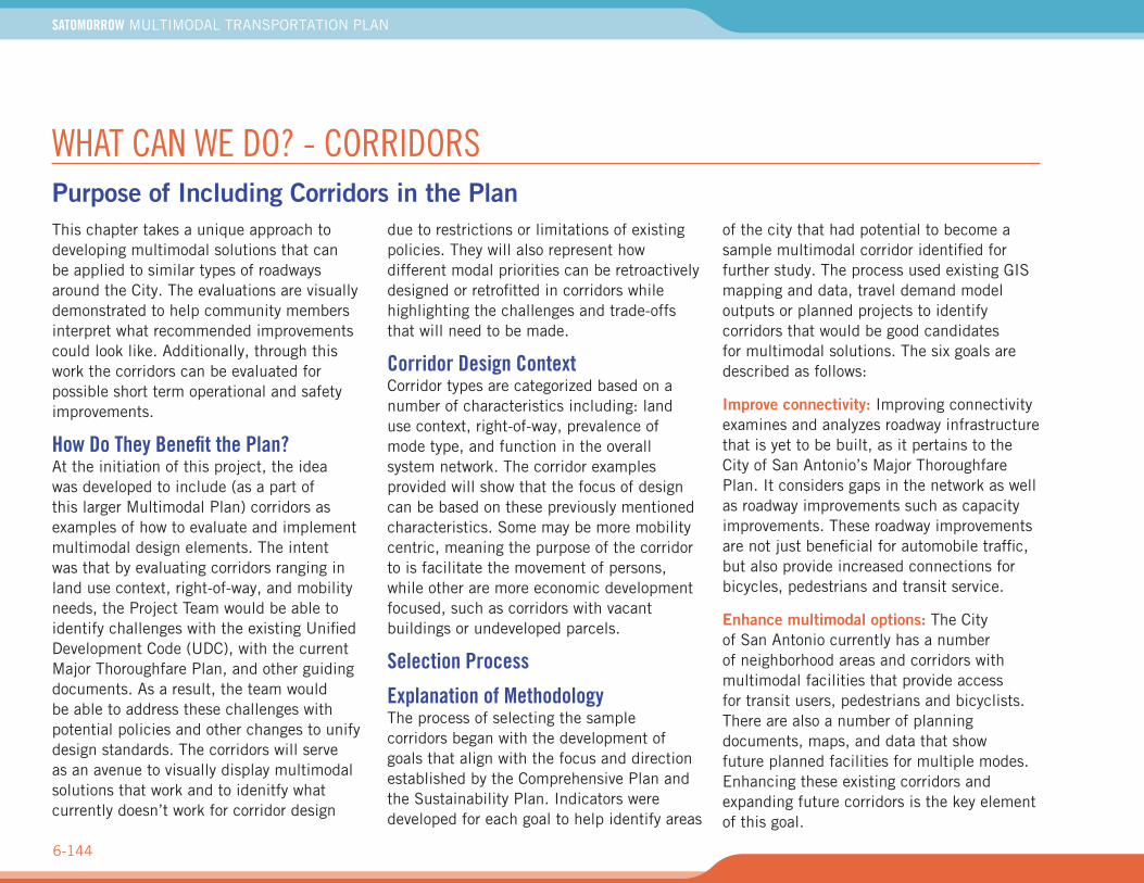
WHAT CAN WE DO? - CORRIDORSPurpose of Including Corridors in the PlanThis chapter takes a unique approach to developing multimodal solutions that can be applied to similar types of roadways around the City. The evaluations are visually demonstrated to help community members interpret what recommended improvements could look like. Additionally, through this work the corridors can be evaluated for possible short term operational and safety improvements.
How Do They Benefit the Plan?At the initiation of this project, the idea was developed to include (as a part of this larger Multimodal Plan) corridors as examples of how to evaluate and implement multimodal design elements. The intent was that by evaluating corridors ranging in land use context, right-of-way, and mobility needs, the Project Team would be able to identify challenges with the existing Unified Development Code (UDC), with the current Major Thoroughfare Plan, and other guiding documents. As a result, the team would be able to address these challenges with potential policies and other changes to unify design standards. The corridors will serve as an avenue to visually display multimodal solutions that work and to idenitfy what currently doesn’t work for corridor design
due to restrictions or limitations of existing policies. They will also represent how different modal priorities can be retroactively designed or retrofitted in corridors while highlighting the challenges and trade-offs that will need to be made.
Corridor Design ContextCorridor types are categorized based on a number of characteristics including: land use context, right-of-way, prevalence of mode type, and function in the overall system network. The corridor examples provided will show that the focus of design can be based on these previously mentioned characteristics. Some may be more mobility centric, meaning the purpose of the corridor to is facilitate the movement of persons, while other are more economic development focused, such as corridors with vacant buildings or undeveloped parcels.
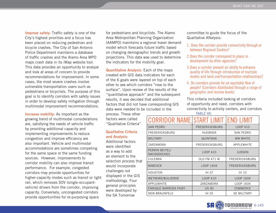
Selection Process
Explanation of MethodologyThe process of selecting the sample corridors began with the development of goals that align with the focus and direction established by the Comprehensive Plan and the Sustainability Plan. Indicators were developed for each goal to help identify areas
of the city that had potential to become a sample multimodal corridor identified for further study. The process used existing GIS mapping and data, travel demand model outputs or planned projects to identify corridors that would be good candidates for multimodal solutions. The six goals are described as follows:
Improve connectivity: Improving connectivity examines and analyzes roadway infrastructure that is yet to be built, as it pertains to the City of San Antonio’s Major Thoroughfare Plan. It considers gaps in the network as well as roadway improvements such as capacity improvements. These roadway improvements are not just beneficial for automobile traffic, but also provide increased connections for bicycles, pedestrians and transit service.
Enhance multimodal options: The City of San Antonio currently has a number of neighborhood areas and corridors with multimodal facilities that provide access for transit users, pedestrians and bicyclists. There are also a number of planning documents, maps, and data that show future planned facilities for multiple modes. Enhancing these existing corridors and expanding future corridors is the key element of this goal.
WHAT CAN WE DO?
6-145
Improve safety: Traffic safety is one of the City’s highest priorities and a focus has been placed on reducing pedestrian and bicycle crashes. The City of San Antonio Police Department maintains a database of traffic crashes and the Alamo Area MPO maps crash data in its iMap website tool. This data provides an opportunity to analyze and look at areas of concern to provide recommendations for improvement. In some cases, the most severe crashes involve vulnerable transportation users such as pedestrians or bicyclists. The purpose of this goal is to identify corridors with safety issues in order to develop safety mitigation through multimodal improvement recommendations.
Increase mobility: As important as the growing trend of multimodal considerations are, satisfying the needs of vehicle traffic by providing additional capacity and implementing improvements to reduce congestion and improve efficiency are also important. Vehicle and multimodal accommodations are sometimes competing for the same space or the same funding sources. However, improvements to corridor mobility can also improve transit performance. For example, congested corridors may provide opportunities for higher-capacity modes such as transit or light rail, which removes SOV (single-occupant-vehicle) drivers from the corridor, improving capacity. Conversely, uncongested corridors provide opportunities for re-purposing space
for pedestrians and bicyclists. The Alamo Area Metropolitan Planning Organization (AAMPO) maintains a regional travel demand model which forecasts future traffic based on changing demographic trends and growth projections. This data was used to determine the indicators for the mobility goal.
Quantitative Analysis: Each of the maps created with GIS data indicators for each of the 6 goals were layered on top of each other to see which corridors “rose to the surface”. Upon review of the results of the “quantitative approach” and the subsequent results, it was decided that additional factors that did not have corresponding GIS data were needed to be included in the process. These other factors were called “Qualitative Criteria”.
Qualitative Criteria and Analysis: Additional factors were identified as a way to add an element to the selection process that would incorporate challenges not displayed in the GIS methodology. Four general principles were developed by the SA Tomorrow
committee to guide the focus of the Qualitative ANalysis:
1. Does the corridor provide connectivity through orbetween Regional Centers?
2. Does the corridor correspond to plans indevelopment by other agencies?
3. Does a corridor present an ability to enhancequality of life through introduction of multiplemodes and land use/transportation relationships?
4. Do corridors provide for an equitable flow ofpeople? (Corridors distributed through a range ofgeographic and income levels)
This criteria included looking at corridors of opportunity and need, corridors with connectivity to activity centers, and corridors
CORRIDOR NAME START LIMIT END LIMITSAN PEDRO FREDERICKSBURG LOOP 410
FREDERICKSBURG HUEBNER SAN PEDRO
MILITARY QUINTANA WW WHITE
ZARZAMORA FREDERICKSBURG APPLEWHITE
PERRIN BEITEL/NACOGDOCHES
LOOP 410 JUDSON
CULEBRA OLD FM 471 W FREDERICKSBURG
BABCOCK LOOP 1604 FREDERICKSBURG
HOUSTON IH 37 IH 10
WETMORE/BULVERDE LOOP 410 LOOP 1604
APPLEWHITE ZARZAMORA LOOP 1604
ENRIQUE BARRERA PKWY US 90 COMMERCE
NEW BRAUNFELS IH 35 SE MILITARY
TABLE XX:
SATOMORROW MULTIMODAL TRANSPORTATION PLAN
6-146
that were identified by other agencies for enhancements. Criterial number 4 was applied first since it was recognized that areas of the City greatly influence the results. The corridors were divided into groups that reflected sub-regions of the City and the highest-ranking corridors from each sub-region were carried forward for application of the other 3 qualitative criteria.
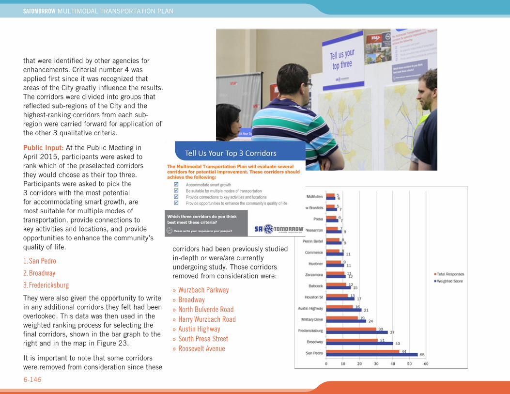
Public Input: At the Public Meeting in April 2015, participants were asked to rank which of the preselected corridors they would choose as their top three. Participants were asked to pick the 3 corridors with the most potential for accommodating smart growth, are most suitable for multiple modes of transportation, provide connections to key activities and locations, and provide opportunities to enhance the community’s quality of life.
1. San Pedro
2. Broadway
3. Fredericksburg
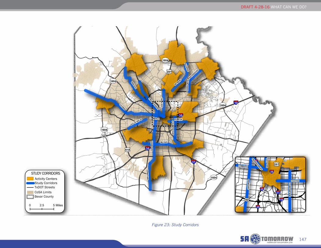
They were also given the opportunity to write in any additional corridors they felt had been overlooked. This data was then used in the weighted ranking process for selecting the final corridors, shown in the bar graph to the right and in the map in Figure 23.
It is important to note that some corridors were removed from consideration since these
corridors had been previously studied in-depth or were/are currently undergoing study. Those corridors removed from consideration were:
» Wurzbach Parkway» Broadway» North Bulverde Road» Harry Wurzbach Road» Austin Highway» South Presa Street» Roosevelt Avenue
DRAFT 4-28-16 WHAT CAN WE DO?
147
Figure 23: Study Corridors
£¤281
£¤90
£¤410
UV1604
UV1604
UV1604
UV1604
UV1604
§̈¦35
§̈¦35
§̈¦37
§̈¦10
MILITARY
FREDERICKSBURG
HOUSTONCOMMERCE
BULVERDE
BABCOCK
NACOGDOCHES
CULEBRA
OLD US HWY 90
WETMORE
ZARZ
AMOR
A
NEW
BRA
UNFE
LS
APPL
EWHI
TE
PERR
INBE
ITEL
SAN
PEDR
O
0 52.5 Miles
TxDOT StreetsCoSA LimitsBexar County
Study CorridorsActivity Centers
STUDY CORRIDORS
§̈¦37
§̈¦10
§̈¦35
§̈¦35
§̈¦10
§̈¦35
£¤90
£¤281
FREDERICKSBURG
HOUSTON
COMMERCE
NEW
BRA
UNFE
LS
SAN
PEDR
O
ZARZ
AMOR
A
SATOMORROW MULTIMODAL TRANSPORTATION PLAN
6-148
CORRIDOR FRAMEWORKEach of the 12 corridors selected for further study are discussed in much greater detail in the following sections. Some of the detailed information obtained for each of the corridors, including existing condition features, current agency plans and challenges and opportunities, is provided in the Appendices. The following pages of maps and graphics display and discuss the multimodal solutions and project team recommendations.
» The existing condition exhibit displays anextensive amount of information on eachcorridor. The information provided a foundationfor the identification of issues and challenges,opportunies, and solutions. The mapping includesa general view of the current corridor crosssection, existing land uses, activity centers,gaps in the sidewalk network (as known by dataprovided by the City of San Antonio), current bikelanes, existing bus stops, current school zones,LOS analysis results, posted speeds, and points ofinterest (See appendices).
» The current agency plans exhibits display the VIAMetropolitan VISION 2040 transit plan features,Lone Star Rail proposed alignment and stationlocations, and the City’s future bike plan featuresas they relate to the corridor (See appendices).
» The challenges and opportunities exhibit marksplaces the Project Team identified as barriers,nodes of interest, places where fatal crashesoccurred, and areas of safety focus (Seeappendices).
The final set of exhibits for each corridor included here are the long- and short-tern recommendations proposed by the Project Team in collaboration with the City and other participating agencies. These maps portray short term recommendations based on public input, agency plans, modeling results, traffic analysis, general engineering concepts and best practices, and other factors. The modeling results for scenarios 1 and 2 (discussed earlier in this document) were used during the analysis to identify recommendations that were possible given the expected demands on the corridor.
Also included are recommendations for policy changes needed to implement the long term and some of the short term improvements.
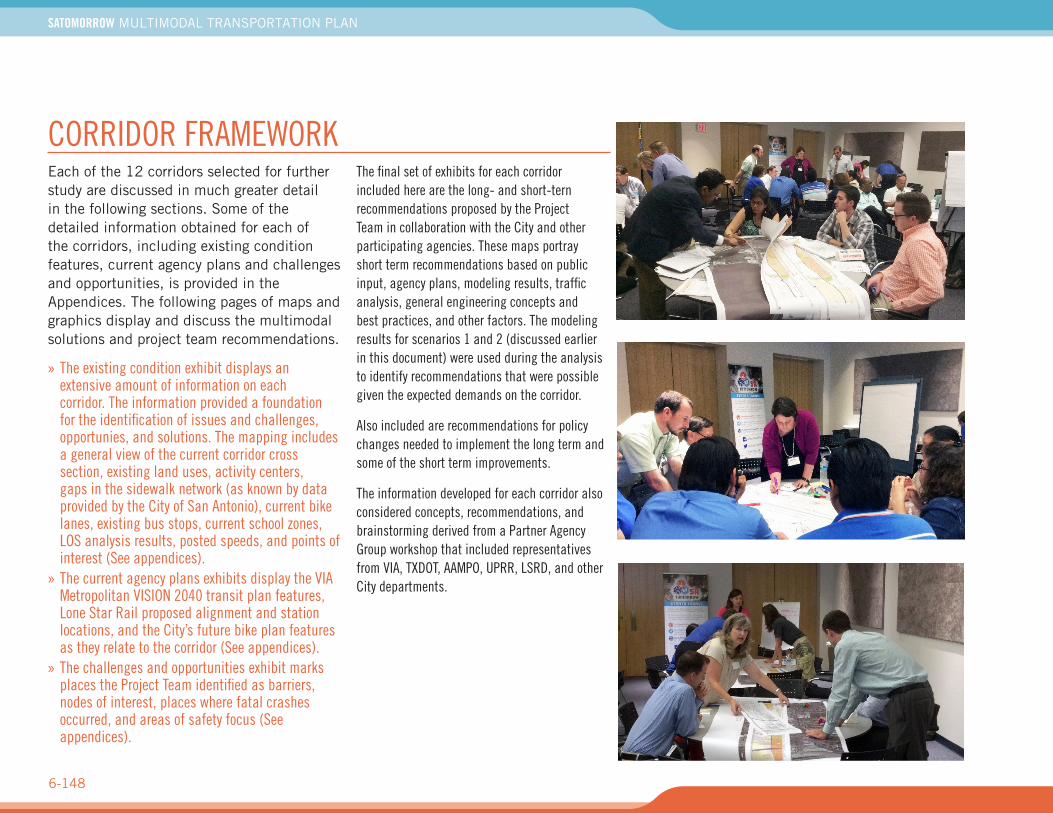
The information developed for each corridor also considered concepts, recommendations, and brainstorming derived from a Partner Agency Group workshop that included representatives from VIA, TXDOT, AAMPO, UPRR, LSRD, and other City departments.
WHAT CAN WE DO?
6-149
CORRIDOR ASSESSMENT & FEASIBILITY EVALUATIONThe following pages will display the following for each study corridor:
» Context» Observations, Challenges and Vision» Short-term Corridor Recommendation» Long-term Multimodal Options» Short-term Recommendations and Benefits Matrix» Short-term Recommendations Mapping
The following corridor information will be located in Appendices.
Mapping:
» Existing Conditions» Agency Plans» Challengs & Opportunities
Analysis:
» Traffic Count Data» Crash Data» LOS Exhibits - 2015, 2040 No Build
5-Year Action Plan ItemsPolicy recommendations and guidance are providedfor each of the corridors based on changes needed torealize the long term multimodal options being shown.Some of the policy changes are directed at land useor regulatory language currently in the City’s UnifiedDevelopment Code (UDC). Other items are reflective oftransformational or aspirational changes needed, forinstance burying overhead utilities as roadways undergoreconstruction.
Each of the 12 corridors demonstrates multimodal concepts as well as short- and long-term improvements and recommendations. The work done for each of the corridors was extensive, but on its own is not sufficient to provide all of the answers to move from here into design. For instance, ROW plays a critical role in what can be included in a future design. A detailed ROW survey is needed to make those final decisions. Environmental constraints and permitting requirements, drainage, and underground utilities also were not included in these corridor evaluations as well as detailed land use evaluations and market analysis.
The next step in the process would be to move forward with 3 to 5 of the corridors evaluated here in the SA Tomorrow Multimodal Transportation Plan using this
work as the foundation for a detailed corridor study. Funding for the corridor studies could come from the Bond Program or could include funds from VIA, the City and/or TXDOT and the AAMPO depending the corridor and the solution. The following corridors are recommended for this next step. Five should be selected from the list shown below. VIA and the City should join forces to lead the corridor studies and ensure that the transit, land use, and complete street components are formulated correctly and support the overall transportation system while meeting the Transportation & Connectivity Goals & Strategies established by the Comprehensive Plan.
1. San Pedro
2. Fredericksburg
3. Zarzamora
4. SE/SW Military
5. Perrin Beitel/Nacogdoches
6. Enrique Barrera Parkway
7. New Braunfels