Embed Size (px)
Citation preview

What is a LAND USE PLAN?
Cities need homes, buildings, schools, parks, roads
and infrastructure to support their residents’ daily
lives. With so many important elements supporting
a great city, how are they organized so that they all
work together?
Most municipalities organize city-building elements
by making land use plans to guide long-term
development. This helps to make sure our city’s
homes and amenities are organized to support
residents, and that there are efficient ways to travel
to work, shopping and fun.
A land use plan is a vision for how we want our city
to grow and change. Plans can vary in scale—some
land use plans apply to all of Edmonton, while others
are focused on a small part of a neighbourhood. This
booklet will explain more about the different types
of land use plans used in Edmonton.

Contents 04 What is a Land Use Plan?
05 Who Makes Land Use Plans?
06 What Kinds of Land Use Plans Are There?
10 We Have a Plan...Now What?
12 How Do Plans Work Together?
13 Why Do Some Plans Disagree?
14 The History of Land Use Plans in Edmonton
14 How is a Land Use Plan Different From The Zoning Bylaw?
3

What is a Land Use Plan?
Land use plans provide a shared vision for our city’s future and a plan for how to get there. They are carefully and collaboratively drafted by city planners, citizens, industry and City Council to proactively manage growth and improve cities.
All land use plans consider the physical or built environment and how it interacts with the natural environment. Land use plans also help to guide the types of future activities or uses that can take place in different areas.
Land use plans can be developed for any scale. They can apply at the:
• Regional level, covering multiple municipalities
• City-wide level, including the location of new neighbourhoods
• Neighbourhood level, including the location of homes, schools, parks, shopping, roads and transit
The physical or built environment includes
things like houses, shops, high rises, roads, street
furniture and playgrounds—basically, anything that
we build.
4

Who Makes Land Use Plans?
People make plans! Some of the people who may contribute to a land use plan include residents, industry, city planners and City Council.
Plans for new communities are typically initiated by developers in consultation with city planners.
In existing neighbourhoods, city planners will work with citizens, stakeholders, builders and other groups to create a plan. City planners use many different types of engagement tools to learn what people think and value. These tools can include open houses, workshops, online surveys and interactive booths at community events, like farmers’ markets or festivals.
City Council must approve all land use plans at a Land Use City Council Public Hearing before they are adopted and used by the City to guide decision making.
The plans we develop now should serve the needs of present-day and future Edmontonians. Working together means that everyone has a say in how our city grows.
5

What Kinds of Land Use Plans Are There?The Alberta Municipal Government Act (MGA) defines and describes the types of land use plans the City of Edmonton uses to manage growth and change. There are two main types of plans described in the MGA: statutory and non-statutory plans.
Statutory Plans
A statutory plan is a document that has been adopted by City Council as a Bylaw, which requires three readings at a special City Council meeting called a Public Hearing. Statutory plans must be considered when planners and development officers exercise discretion in the decision making process. The MGA lists the types of possible statutory plans, including:
Area Structure Plans
Regional Plans Municipal Development Plans
Area Redevelopment Plans
6

REGIONAL PLANS
Regional plans consider matters that impact multiple jurisdictions or municipalities. Environmental, social and economic issues often cross city or town boundaries and require big-picture solutions. A collaborative approach to planning is needed to balance factors and interests such as population growth, urban sprawl, maintaining farmland, planning efficient transportation networks and protecting natural areas. By working on issues that cross boundaries together, the outcome is more comprehensive and effective.
Edmonton is the largest city within the Capital Region and a member of the Edmonton Metropolitan Region Board, or EMRB.1 The EMRB is a group of 24 municipalities that work together to ensure long term economic prosperity and quality of life for all citizens within the Edmonton Metropolitan Region. The Edmonton Metropolitan Region Growth Plan, Re-imagine. Plan. Build. was delivered to the Government of Alberta in 2016, and provides broad policy direction for all member municipalities to follow. It is an update to the 2010 Growth Plan: Growing Forward.
CITY-WIDE PLANS
A Municipal Development Plan (MDP) is a city-wide strategic growth and development plan. Under the Municipal Government Act, every municipality with more than 3,500 people must have an MDP. MDPs are the only statutory plans listed in the Municipal Government Act that are not optional.
Edmonton’s MDP is The Way We Grow, which was adopted in 2010. It is the highest level statutory plan in Edmonton. It outlines land use policies and growth targets designed to guide the city’s evolution and development for the next ten years. The Way We Grow is closely integrated with Edmonton’s Transportation Master Plan (TMP), The Way We Move. This ensures future land use, growth patterns and transportation systems within Edmonton are coordinated.
1 formerly known as the Capital Region Board or CRB, with the new EMRB pending Provincial
approval of the new legislation in 2017.
7

PLANS IN MATURE AND ESTABLISHED NEIGHBOURHOODS
An Area Redevelopment Plan (ARP) outlines a vision for growth and change in areas of the city that have already been developed. An ARP should align with the overall vision and strategic direction for the city described in the MDP. Boundaries for an ARP are often driven by context and are not necessarily the same as neighbourhood boundaries. ARPs usually include and consider significant amounts of community and stakeholder input before being considered and passed by City Council.
Today, many of the new ARPs in Edmonton are focused on commercial or main street corridors, or areas around existing or future LRT stations. This is because these are the places that planners and City Council anticipate seeing the most change and need for extra planning to guide growth.
PLANS FOR NEW AREAS
Area Structure Plans (ASPs) lay out an area's long-term plan for development. In Edmonton, ASPs generally cover areas of at least 200 hectares and provide a framework for the development of several neighbourhoods.
Neighbourhood Structure Plans (NSP) are sub-plans that support an Area Structure Plan. An NSP will describe the vision and general patterns of development for a new community. They usually apply to areas that affect between 4,000 to 7,000 people.
Together, ASPs and NSPs identify where residential, commercial, institutional and recreational development will be located, and how essential municipal services such as water, sewer systems, arterial and collector roads, schools, parks and fire protection will be provided. These plans also identify how development will be staged over time, and will set density targets to help new development meet city-wide and Edmonton Metropolitan Region growth objectives.
8

Non-Statutory Plans
In addition to statutory plans, City Council may adopt other policy documents that guide decision making. These are sometimes referred to as non-statutory plans. These types of planning documents are also supported by public consultation, evidence and best practices. They can be very influential and provide sound guidance for decision making.
Policy plans can include design guidelines, planning strategies, implementation plans and other planning documents. Some examples of non-statutory plans in Edmonton include:
Climate Change and Adaptation Strategy
Winter Design Guidelines
Historical Resources Management Plan
Energy Transition Strategy
9

Realizing the vision for the future described in a land use plan is a long-term process that can happen over decades. Success depends on collaboration between home owners, citizens, stakeholders, industry and the City of Edmonton. This collaboration is important because of the many factors that affect city growth that the City cannot control, including:
We Have a Plan… Now What?
What the landowner wants to do.
Do they want to keep their property as it is, redevelop it themselves or sell it to someone else?
Are the lots the right size to build what is outlined in the plan?
Sometimes lots have to be consolidated together into a bigger parcel or subdivided into smaller lots to support certain kinds of new buildings. Consolidation, in particular, can take time as it typically relies on multiple landowners all agreeing to sell their land for redevelopment.
10
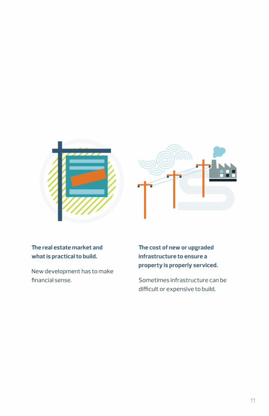
The cost of new or upgraded infrastructure to ensure a property is properly serviced.
Sometimes infrastructure can be difficult or expensive to build.
The real estate market and what is practical to build.
New development has to make financial sense.
11

There are over 180 plans in the City of Edmonton. The only way all these plans can work together to achieve a common vision for the future is through a recognized hierarchy of plans.
The direction provided by plans at the top of the hierarchy is fairly general. As you go down the hierarchy, guidance becomes more specific and detailed. Planning done at any level of the hierarchy should comply with the direction given by plans above it and must give direction to the more specific plans below it.
MUNICIPAL DEVELOPMENT PLAN (MDP) THE WAY WE GROW
ZONING BYLAW
AREA REDEVELOPMENT
PLANS (ARP)
AREA STRUCTURE PLANS (ASP)
MUNICIPAL GOVERNMENT ACT (MGA)
EDMONTON METROPOLITAN REGION GROWTH PLAN
An ARP may replace an ASP as the
neighbourhood moves into a new stage of its
lifecycle.
Direction for the Zoning Bylaw flows from
the MDP and potentially from ASPs or ARPs. The Zoning
Bylaw contains the prescriptive development regulations for sites, with the plans guiding
discretion.
How Do Plans Work Together?
12

Why Do Some Plans Disagree?You may find that some older plans don’t conform to the vision set out in the Municipal Development Plan. How come?
This is because ideas and best practices for land use planning change over time as planners, residents, industry and City Council learn from past redevelopment experience, best practices from other places, and new theories and ideas about urban growth. The way we plan also adapts over time to reflect the needs of a changing city and our residents.
Planning work tends to focus on key areas identified for major growth and change. This means that older plans might not be regularly updated. Focusing on the areas identified for change means that City resources are directed to the places that need the most support. The result is that sometimes, older planning documents may reflect Edmonton’s past and are not as prepared for Edmonton’s future.
13

The History of Land Use Plans in Edmonton
Edmonton’s current Municipal Development Plan, The Way We Grow, was approved in 2010. It embraces development “up, in and out.”
Land use planning began in Edmonton when a settlement was established outside the fort. A public meeting to discuss the location of a main street and market square was held in 1881.
Edmonton’s first city-wide plans were prepared in 1907 and 1912. These plans focused on beautification and resulted in the city’s first parks, the downtown civic centre and preservation of most of the river valley.
Edmonton grew rapidly after World War II because of the baby boom and discovery of oil nearby. In 1949, the City of Edmonton hired Noel Dant to establish a planning department. Dant and his successors prepared dozens of neighbourhood unit plans for areas such as Parkallen, Sherbrooke, Holyrood and Meadowlark Park. These were plans for the auto age, with street networks designed to discourage traffic near homes and schools but with wide roads at the edges of neighbourhoods to connect drivers to offices and industry.
Planning on a larger scale began in the 1960s with a move toward plans that applied to many neighbourhoods at once. The first of these was the 1971 Mill Woods Development Plan, which identified eight new communities and a town centre.
The 1960s also saw the first comprehensive municipal plans. The first municipal plan was prepared in 1963. It was revised multiple times and finally adopted in 1971.
New municipal plans with policies reflecting their times were approved in 1980, 1990 and 1998.
14

How is a Plan Different From the Zoning Bylaw?Land use plans set out the big picture vision for an area. They are high level overviews of how an area or neighbourhood will develop. The Zoning Bylaw is the main tool that the City uses to implement the goals and objectives in land use plans.
Zoning is the legal tool that describes how buildings are situated on an individual site, as well as building size and the type of activities that can take place inside of them. It ensures new buildings support the vision in the land use plan. The Zoning Bylaw establishes development standards within each zone and provides a system for issuing development permits.
If you would like to know more about Zoning, please see the What Is Zoning? booklet.
15

Learn more about land development at edmonton.ca