Embed Size (px)
Citation preview

What is Geography?

Students will able to:
• Define Geography
• Explain the 5 Themes
• Analyze the 5 Themes with an example

What is Geography
• Geography is about spatial thinking
• The questions we want to ask “What is where, Why there, and Why care?”
• This quote comes from By Charles F. Gritzner South Dakota State University

By Charles F. Gritzner South Dakota State University
• Please read the article: http://apcentral.collegeboard.com/apc/members/courses/teachers_corner/155012.html
• Dr. Gritzner
• Be able to give the examples (Figure 1)
• What is?
• Where?
• Why there?
• Why care?

5 Themes of Geography
• Location
• Place
• Human – Environment Interaction
• Movement
• Regions

Location
• Absolute Location – a specific description of the Where of a place, through the use of coordinates, street address, mile markers, etc.
• Relative location – a description of the Where of a place by comparing it to the Where of another place. California University of Pennsylvania is 35 miles southeast of Pittsburgh.

Place
• The Physical Description of a place – Landscape, Climate, etc.
• The Human Description of a place – Economics, Politics, Culture, etc.

Human – Environment Interaction
• Humans modify their environment
• Humans depend on their environment
• Humans adapt to their environment
Movement
• Humans
• Goods
• Ideas

Regions
• Formal Region
• Functional Region
• Vernacular Region

Major Tool for Geographers - Maps
• Example of 5 Themes
• Now we are going to examine the 5 Themes using the Persian Gulf War.

Why Did the US go to War in Persian Gulf?
• In March 2017 – Dr. Hal Brands discussed this question at the Foreign Policy Research Institute’s Why Does America Go to War? Education Workshop
• http://www.fpri.org/multimedia/2017/03/tthe-persian-gulf-war-1990-1991/
• This can be answered be examining smaller questions?

Why Did Saddam Invade Kuwait?
• Aggression
• Opportunity
• Insecurity

Aggression
• Saddam was an contentious leader
• Determined to be boss of “Arab world” • 10:21, Dr. Brands, Persian Gulf War, FPRI Video

Opportunity
• Iraq had developed quite a powerful military as it fought Iran. Iran had been weakened
• Kuwait was fragile and other Arab countries were not fans
• 11:34, Dr. Brands, Persian Gulf War, FPRI Video
• Let’s use Relative Location to examine these issues.

Iraq – Relative Location

Insecurity
• Saddam was in trouble economically due to the Iran Iraq War
• Saddam felt Kuwait produced more oil, which caused oil prices to drop. He has trouble paying back debt
• Circle of Danger – “Israel and United States were working with Kuwait against Iraq”
• 13:20, Dr. Brands, Persian Gulf War, FPRI Video

Border Dispute Between Iraq vs. Kuwait 16:20, Dr. Brands, Persian Gulf War, FPRI Video

Geopolitical Issues
• Dr. Brands states that the US moved half of their combat power into the Persian Gulf area.
• Dr. Brands discussed the Global Economics involved in this situation.
• Now let us look at that with the 5 themes

Map of Cities with American Naval Ships
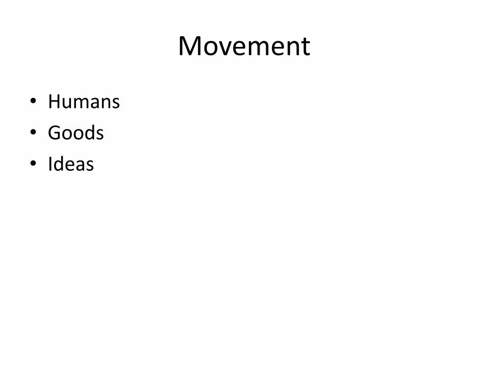
Points – Center of City

Imagery and Measure the Distance to the Water

Place

Zoom out – Why were the ships at these locations?

Before and After

Human Environment Interaction (Yellow Represents Oil Fields)

Movement

What Changed?

Final Step
• Discuss with the students the fall of the USSR and ability to move naval power to assist in the Persian Gulf War
• Discuss Dr. Brands points on the amount of oil that Saddam Hussein would have been able to control.

Bibliography
• Dr. Brands, Persian Gulf War, FPRI Video, http://www.fpri.org/multimedia/2017/03/tthe-persian-gulf-war-1990-1991/
• Matthews, James and Cora J. Holt (1991). So Many, So Much, So Far, So Fast: United States Transportation Command and Strategic Deployment for Operation Desert Shield / Desert Storm. http://www.history.army.mil/html/bookshelves/resmat/dshield_dstorm/somanysomuch.pdf

Bibliography
• Gritzner, Charles F. Defining Geography: What is Where, Why There, and Why Care?, http://apcentral.collegeboard.com/apc/members/courses/teachers_corner/155012.html
• ArcGIS Online http://www.arcgis.com

1

2
3

4

5

6

7

8

9

10

11

12

13

14

15

Have your students describe Iraq in relative location terms. (To Iran, To Kuwait, To Saudi Arabia, to Persian Gulf, etc.) Teacher can go to http://www.arcgis.com to make map more interactive (Zoom in, etc.)
16

17

Have your students discuss the issues of Borders. What Physical Features sometimes form borders? How do they think other borders are ‘Drawn” Read this article about the Iran Iraq War - Have students read: http://news.bbc.co.uk/2/hi/middle_east/4260420.stm Listen to 16:20 of the video on this topic
18

19

This information was taken from: Matthews, James and Cora J. Holt (1991). So Many, So Much, So Far, So Fast: United States Transportation Command and Strategic Deployment for Operation Desert Shield / Desert Storm. http://www.history.army.mil/html/bookshelves/resmat/dshield_dstorm/somanysomuch.pdf p. 263 - 265
20

The exact point is city’s center. It is defined by the Latitude and Longitude – An Absolute Location
21
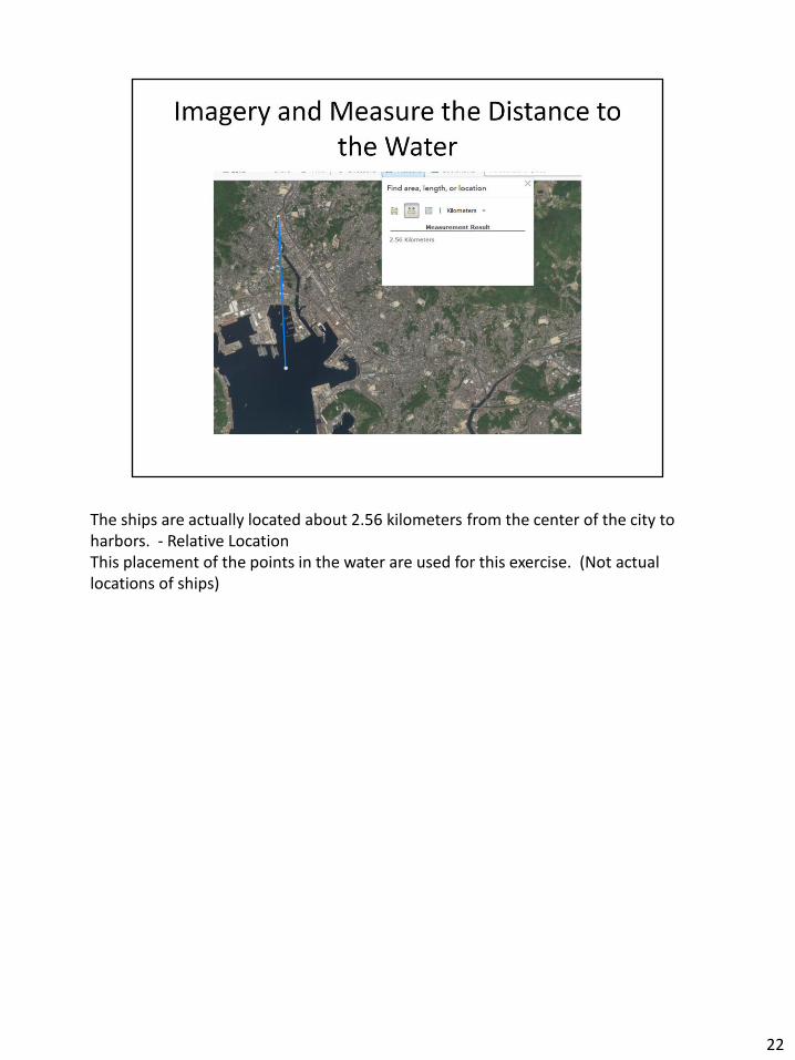
The ships are actually located about 2.56 kilometers from the center of the city to harbors. - Relative Location This placement of the points in the water are used for this exercise. (Not actual locations of ships)
22

Ask students to examine the different points and describe the physical and human landscapes. Teacher can go to http://www.arcgis.com to make map more interactive (Zoom in, etc.)
23
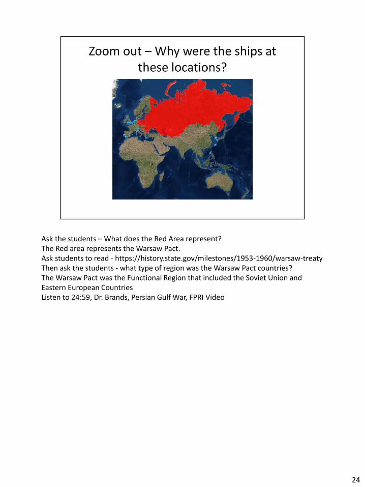
Ask the students – What does the Red Area represent? The Red area represents the Warsaw Pact. Ask students to read - https://history.state.gov/milestones/1953-1960/warsaw-treaty Then ask the students - what type of region was the Warsaw Pact countries? The Warsaw Pact was the Functional Region that included the Soviet Union and Eastern European Countries Listen to 24:59, Dr. Brands, Persian Gulf War, FPRI Video
24

Blue Stars – US Naval Ships at Foreign Ports Before the Persian Gulf War Red Stars – US Naval Ships at Foreign Ports During the Persian Gulf War – This included about 33 ships (Matthews and Holt, 1991). (There were more ships coming from American Ports) Examine the Change Listen to 30:20, Dr. Brands, Persian Gulf War, FPRI Video
25

Human Environment Interaction: We depend on oil. Start a discussion about the connection between Oil, Development and Power Dr. Brands states that with Kuwait under Saddam’s control. He now had 20% of the oil reserves If he continued to eastern Saudi Arabia (Remember map) – he would have 40 – 50% of oil reserves Video 21:00, Dr. Brands, Persian Gulf War, FPRI Video
26

Obviously the movements do not follow this path, but give an example of the movement of these ships.
27

Soviet Union fell and Warsaw Pact fell apart During the Persian Gulf War, the United States formed a Coalition shown in tan. Examine the states involved in the Coalition. Some of Arab states, some of Eastern European countries (former members of the Warsaw Pact) 28:48, Dr. Brands, Persian Gulf War, FPRI Video
28

29

30

31