Embed Size (px)
Citation preview
1
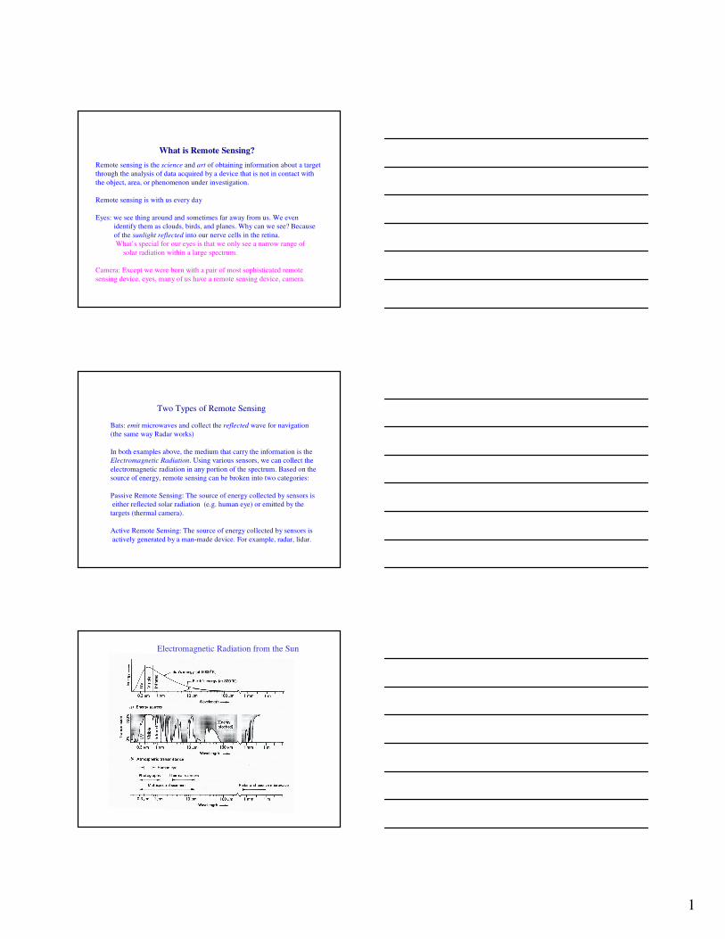
What is Remote Sensing?
Remote sensing is the science and art of obtaining information about a target
through the analysis of data acquired by a device that is not in contact with
the object, area, or phenomenon under investigation.
Remote sensing is with us every day
Eyes: we see thing around and sometimes far away from us. We even
identify them as clouds, birds, and planes. Why can we see? Because
of the sunlight reflected into our nerve cells in the retina.
What’s special for our eyes is that we only see a narrow range of
solar radiation within a large spectrum.
Camera: Except we were born with a pair of most sophisticated remote
sensing device, eyes, many of us have a remote sensing device, camera.
Bats: emit microwaves and collect the reflected wave for navigation
(the same way Radar works)
In both examples above, the medium that carry the information is the
Electromagnetic Radiation. Using various sensors, we can collect the
electromagnetic radiation in any portion of the spectrum. Based on the
source of energy, remote sensing can be broken into two categories:
Passive Remote Sensing: The source of energy collected by sensors is
either reflected solar radiation (e.g. human eye) or emitted by the
targets (thermal camera).
Active Remote Sensing: The source of energy collected by sensors is
actively generated by a man-made device. For example, radar, lidar.
Two Types of Remote Sensing
Electromagnetic Radiation from the Sun
2
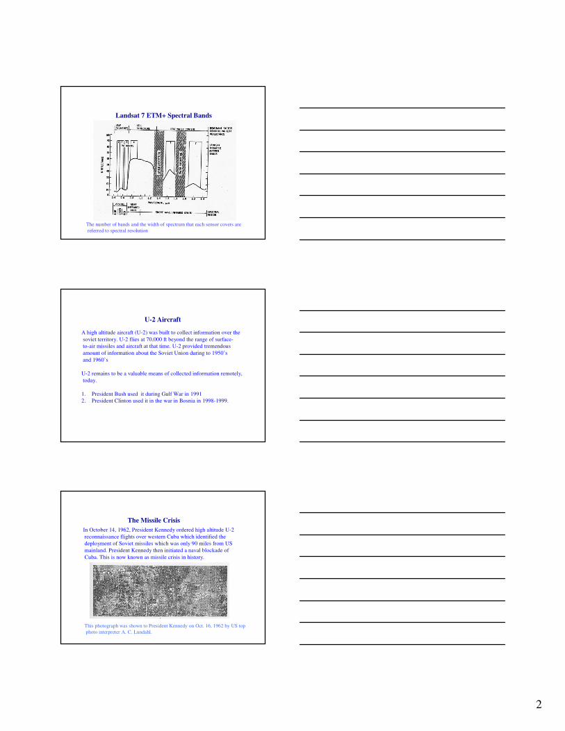
Landsat 7 ETM+ Spectral Bands
The number of bands and the width of spectrum that each sensor covers are
referred to spectral resolution
U-2 Aircraft
A high altitude aircraft (U-2) was built to collect information over the
soviet territory. U-2 flies at 70,000 ft beyond the range of surface-
to-air missiles and aircraft at that time. U-2 provided tremendous
amount of information about the Soviet Union during to 1950’s
and 1960’s
U-2 remains to be a valuable means of collected information remotely,
today.
1. President Bush used it during Gulf War in 1991
2. President Clinton used it in the war in Bosnia in 1998-1999.
The Missile Crisis
In October 14, 1962, President Kennedy ordered high altitude U-2
reconnaissance flights over western Cuba which identified the
deployment of Soviet missiles which was only 90 miles from US
mainland. President Kennedy then initiated a naval blockade of
Cuba. This is now known as missile crisis in history.
Figure 3-8 a of Jensen
This photograph was shown to President Kennedy on Oct. 16, 1962 by US top
photo interpreter A. C. Lundahl.

3
Satellite Remote Sensing—Landsat 7
Sun-synchronous orbit:
Satellite always crossed the
equator at precisely the same
local time.
Swath Width and Field of View
185 km
Field of View
175km
scene
Landsat
Satellite
ground track
705km
Spatial Resolution
Pixel size=
(30x30m)
Temporal Resolution
The shortest time needed to repeat a ground track

4
What is Digital Remote Sensing?
Digital remote sensing literally means that the remotely sensed
products are digits or numbers other than films
Information on the film: Information recorded on a film is
essentially the amount of reflected sun light back into space from
the ground surface. Different ground object reflect different
amount of energy leading to a different extent of exposure on
the film. The developed photos is the printed version of sun light
reflected from the target. The interpreter has to extract information
based on the shape, size, tune, texture to identify targets.
1010 30
25
5
30
10
30 30
1. Space is covered continuously
with cells.
2. Each cell has one number
indicating the amount of
energy received from the cell
3. The cell is called pixel
(picture element)
4. The size of the pixel is the
spatial resolution
sensor
Digital Images
1010 30
25
10
30
10
20 15
1010 30
25
5
30
10
30 30
301 40
15
30
30
12
20 40
Multispectral remotely sensed data
Each band will generate a layer of remotely sensed data, usually
with the same cell (pixel) size. For Landsat satellite, we will have
6 layers of data corresponding to the 6 bands.

5
Color Arithmetic
red+green=yellow
green+blue=cyan
red+blue=magenta
How to Make Photos with Numbers?
red
blue
green
white
yellow
black
cyan
magenta
Color Space
Vegetation Information
Normalized Difference Vegetation Index
dNIR
dNIR
RR
RRNDVI
Re
Re
+
−=
NDVI: [-1.0, 1.0]
Often, the more the leaves of vegetation present, the bigger the
Contrast in reflectance in the red and near-infrared spectra.

6
Phenology from AVHRR
Feb 27-Mar 12
Jul 17-Jul 30
Aug 14-Mar 27
Jun 19-Jul 2
Apr 24-May 7
Nov 6-19
Orbit: 705 km,
Time to cross equator: 10:30 a.m.
sun-synchronous, near-polar, circular
Sensor Systems: Across Track Scanning
Radiometric resolution: 12 bits
Temporal resolution: 2 days
Spatial Resolution:
250 m (bands 1-2)
500 m (bands 3-7)
1000 m (bands 8-36)
Design Life: 6 years
MODIS
MODIS
Bands

7
Monitoring forest fire
Pre-forest fire
Post-forest fire
Burned area identified from space
This is the image from MODIS
showing the wide sediment plume
of Yangtze River as it runs into the
East China Sea. Yangtze River,
originating from the Himalayans, is
the longest river in China (6380km),
the third longest in the world after
the Amazon, and the Nile. The
world largest dam, the Three Gorges
Dam, is now being built in Sichuan
province. Due to deforestation in the
upper reaches of the river, many
fear that the river will become the
second Yellow River in China.
Color, size, and tone are all
helpful to identify the severity
and extension of soil erosion
Land-Ocean Interactions
Sea Surface Temperature

8
This is MODIS image shows temperature of Gulf Stream. The current stretches from the
Gulf of Mexico up the East Coast of the United States and departs from North America
Heading across the Atlantic to British Isles. This warm current creates a moderate
Northern European climate.
Warm core rings
rotate clockwise
Cold core rings
rotate counter clockwise
Gulf Stream
Spectral Properties of Water with Algae
Algae is the primary plant in the ocean that absorbs CO2, in the meantime initiate
the food chain in the ocean. It is very important to understand its spatial and
temporal dynamics.
Phytoplankton bloom in
the Black Sea. MODIS
band 1 (red), 4 (green)
and 3 (blue)
9
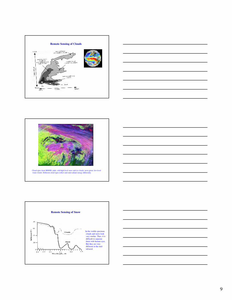
Remote Sensing of Clouds
Cloud types from MODIS: pink: cold high level snow and ice clouds; neon green: low level
water clouds. Different cloud types reflect and emit radiant energy differently.
Remote Sensing of Snow
In the visible spectrum
clouds and snow look
very similar. Thus, it is
difficult to separate
them with human eyes.
But they are very
different in the mid-
infrared.

10
A massive iceberg, one of the largest ever observed, broke off the Ross Ice Shelf
near Roosevelt Island in Antarctica in mid-March 2000. This Iceberg is about
40 miles wide and 300 miles long. The break off of such big iceberg may be
related to global climate change.
Change Detection
Landsat 5 TM image on Dec 10,
1988 at Shenzhen special econ.
zone, China (RGB=432)
Landsat 5 TM image on Dec 30,
1995 at Shenzhen special econ.
zone, China (RGB=432)


![パルメイラス(サンパウロ) S.E PALMEIRAS[ SAO PAULO] · 2019-06-10 · Green White Blue Red White Green Blue Red Green White Blue Red 1st 2nd 1st 2nd FP FP GK GK Uniform](https://img.pdfslide.net/doc/110x75/5e8d4e019b29c6379b37cc32/ffffifffi-se-palmeiras-sao-paulo-2019-06-10-green.jpg)