Embed Size (px)
Citation preview

Chapter 2 | Vision and Goals 35
What should the future hold for Waxahachie? What will the City be like in 20 years? This section addresses these key
questions and identifies a vision for this comprehensive planning effort, as well as for the City of Waxahachie in general. The
vision will help guide growth and development in the City for the next ten years and beyond. This section will also be the
basis for many of the recommended actions and implementation efforts of this comprehensive plan. A vision is reflective of
the many tangible and intangible characteristics and values that Waxahachie desires to preserve and provide for current
residents and future generations of residents who will call the community home.
Developing a vision is an important step that involves conducting exercises pertaining to what those values and
characteristics are and how they may be conveyed and reflected within the physical environment. The vision exercises were
conducted with the Comprehensive Plan Advisory Committee (CPAC), which was made up of the City Council and Planning &
Zoning Commission. This group of elected and appointed officials was representative of the community. The CPAC assisted
not only in developing the vision, but overseeing and guiding the development of the entire comprehensive plan.
Issue identification exercises were conducted during the first
CPAC meeting on July 6, 2015. Issue identification is critical in
creating a comprehensive plan that is responsive to the City’s
needs. The CPAC members were asked to identify issues they
believed were important for the comprehensive plan to
address. The CPAC was asked to identify issues related to five
general topics:
1. Missing Land Uses
2. Corridors
3. Transportation
4. Housing
5. Growth
The group had an open discussion on each topic and their thoughts were recorded on a flip chart. Figure 9 is a summary of
the discussion and lists the issues that were identified. The group also participated in a short Strength-Weaknesses-
Opportunities-Threats (SWOT) analysis, shown in Table 10.
CPAC Listening to Presentation on July 6, 2015

Chapter 2 | Vision and Goals 36
Table 10. SWOT Analysis Results
STRENGTHS WEAKNESSES OPPORTUNITIES THREATS
History Vision
Location Community
Character/uniqueness
Highway appeal Economic diversity
Lack of jobs Lack of cultural balance
Transportation
Medical/education Land value
Infrastructure East-west connection
Location
Lack of control Ourselves
Land use balance Funding
Lack of focus
HOUSING
Need for “life-cycle” housing More open areas and less subdivisions Residential cohesiveness Need for higher-end housing Zero-lot lines Diverse housing stock Multi-family/townhomes (quality, high-end)
WHERE SHOULD WE GROW?
Northwest quadrant growing fast Would like to grow all ways (southwest will be
the last area) Where there is infrastructure
MISCELLANEOUS INPUT
Maintain character Preparing for aging Baby Boomers Appealing to Millennials Quality of life Quality development Public spaces Would like to model McKinney Does not want to be like Frisco, Allen, or Plano
MISSING LAND USES
Department stores Costco/Sam’s Club Medical-related uses Natatorium (for all ages) Recreation/entertainment for youth Family-oriented activities Arts and music Splash pad near downtown
CORRIDORS
US 287 - Develop the bypass area IH-35E
o Not all warehouses o Feel of Georgetown o Retail opportunities o Attract tourists to come downtown o Let trucks pass through o Technology centers
TRANSPORTATION
IH-35 connectivity Trail connectivity Greenways Transit around town/trolley system Street improvements (entire city) Butcher Road (4 lanes) Brown Road (north-south) Downtown mobility (Ferris Road) Public transit (Dallas connection)
Figure 9. Issue Identification Results

Chapter 2 | Vision and Goals 37
The CPAC held a second meeting on July 23, 2015 to give their input on the 2007 Plan, specifically what needed to stay in the
plan and what needed to be updated. The CPAC also developed seven big ideas to guide the development of the new
comprehensive plan.
The CPAC voted on key policies of the 2007 Comprehensive Plan. The members indicated whether or not the policy should be
kept, updated, or removed. Table 11 shows the results of the existing plan input exercise. The CPAC generally agreed that all
of the policies should be kept; however, many of the policies have been updated in the plan based on the results.
Table 11. Input on Policy Updates
POLICY KEEP UPDATE REMOVE
Consider Context-Sensitive Design (CSD) solutions for new roadways and roadway improvements
67% 33%
Use positive aesthetics along roadways to enhance Waxahachie’s character
33% 67%
Proactively pursue improvement of the US 77 corridor
50% 50%
Carefully consider any requested “upzoning” of property
67% 33%
Encourage connectivity between developments
83% 17%
Integrate sustainability concepts into land use decisions
58% 42%
Encourage mixed use development 58% 42%
Encourage development of unique neighborhoods for maximum sustainability
67% 33%
Provide for limited, traditional multi-family development
58% 33% 8%
Encourage unique retail development with sustainable characteristics
67% 33%

Chapter 2 | Vision and Goals 38
Based on the review of the 2007 Comprehensive Plan and the input received from the CPAC meetings, seven big ideas were
created to help guide the plan. These big ideas help to inform policies, recommendations, and actions for transportation,
future land use, growth strategies, and corridor design. The big ideas create a focus for the plan and help to achieve the
vision of what Waxahachie wants to become.
How should this develop?
The west side of IH-35E, north of 287, is a prime location for
development in Waxahachie. Most of the area is currently vacant,
with some industrial uses. This area has roadway access to 287 and
IH-35E, which allows for regional connections. The future land use
plan will propose new uses for this area and address the question
of “how will this area develop?”
Chapter 2 | Vision and Goals 39
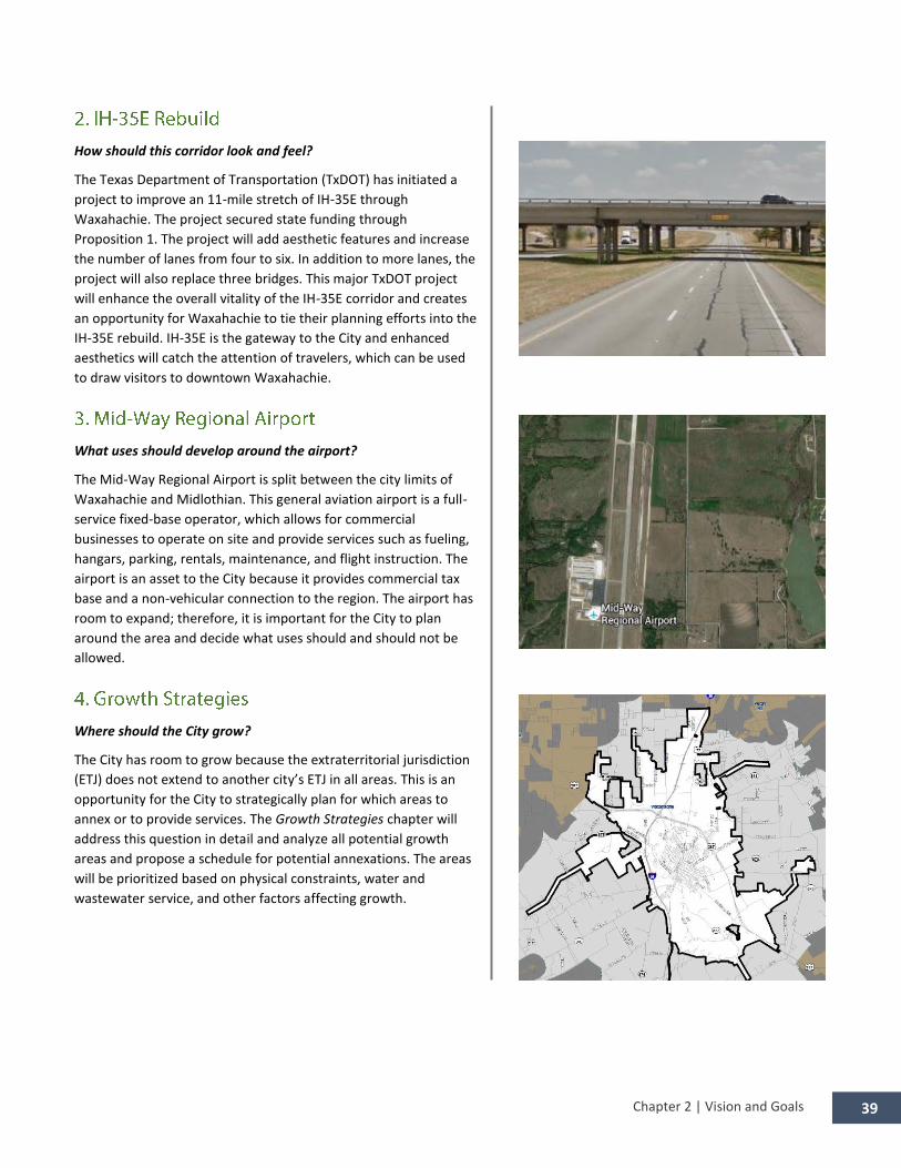
How should this corridor look and feel?
The Texas Department of Transportation (TxDOT) has initiated a
project to improve an 11-mile stretch of IH-35E through
Waxahachie. The project secured state funding through
Proposition 1. The project will add aesthetic features and increase
the number of lanes from four to six. In addition to more lanes, the
project will also replace three bridges. This major TxDOT project
will enhance the overall vitality of the IH-35E corridor and creates
an opportunity for Waxahachie to tie their planning efforts into the
IH-35E rebuild. IH-35E is the gateway to the City and enhanced
aesthetics will catch the attention of travelers, which can be used
to draw visitors to downtown Waxahachie.
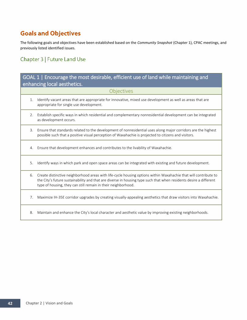
What uses should develop around the airport?
The Mid-Way Regional Airport is split between the city limits of
Waxahachie and Midlothian. This general aviation airport is a full-
service fixed-base operator, which allows for commercial
businesses to operate on site and provide services such as fueling,
hangars, parking, rentals, maintenance, and flight instruction. The
airport is an asset to the City because it provides commercial tax
base and a non-vehicular connection to the region. The airport has
room to expand; therefore, it is important for the City to plan
around the area and decide what uses should and should not be
allowed.
Where should the City grow?
The City has room to grow because the extraterritorial jurisdiction
(ETJ) does not extend to another city’s ETJ in all areas. This is an
opportunity for the City to strategically plan for which areas to
annex or to provide services. The Growth Strategies chapter will
address this question in detail and analyze all potential growth
areas and propose a schedule for potential annexations. The areas
will be prioritized based on physical constraints, water and
wastewater service, and other factors affecting growth.

Chapter 2 | Vision and Goals 40
What should be connected?
Trail connections are vital to a city’s quality of life. Waxahachie
currently has a trail system in place which connects various areas of
the City and also provides regional connections. It is critical to plan
for new trail connections to enhance the City’s non-vehicular
mobility. The trail connections should be planned in coordination
with the Future Land Use Plan Map to ensure that new
developments are accessible. It is also important that trails connect
to places where resident and visitors want to go. Downtown, the
Medical Center District, schools, and parks are all examples of
attractive destinations.
What are the boundaries and what uses should develop?
The proposed Medical Center District is located around the newly
constructed Baylor Scott & White Medical Center on the east side of
IH-35E with some land located on the west side of IH-35E. This area
has the potential for mixed use development, transit, trail
connections, and much more. The Future Land Use Plan Map will
help to better define the boundaries of the Medical Center District
and establish what type of uses should develop in the area.
Where do roads need built or rebuilt?
For successful implementation of this 2016 Comprehensive Plan
Addendum, actions and recommendations for future projects must
be made. Strategic prioritization of projects through a CIP will help
the City to identify which projects need to be built first and will also
help the City to be fiscally responsible. The Implementation Matrix
will prioritize actions and strategies for implementing the plan,
which will assist the City in the preparation of a CIP.

Chapter 2 | Vision and Goals 41
The vision is an encompassing statement that describes the overriding needs and desires of Waxahachie’s community
representatives, leaders, and stakeholders. Throughout the chapter, expressions of what Waxahachie should ultimately be in
the future have been discussed. These expressions have been derived from numerous issue identification and vision meetings
with the CPAC. All of the information obtained during the process was used to create such a statement. The vision for
Waxahachie that results is as follows:
Waxahachie is a City that embraces its heritage while looking toward to the future; a City that:
Engages in balanced and responsible urban design, planning, and development;
Accommodates and encourages change in a manner that builds upon local history while
improving quality of life;
Preserves and enhances the City’s unique historical, cultural, and natural resources;
Supports a vibrant and diversified economic climate that provides employment, retains
existing businesses, and attracts new businesses; and
Provides safe, dynamic, and sustainable neighborhoods for people of all ages.
Chapter 2 | Vision and Goals 42
The following goals and objectives have been established based on the Community Snapshot (Chapter 1), CPAC meetings, and
previously listed identified issues.
GOAL 1 | Encourage the most desirable, efficient use of land while maintaining and enhancing local aesthetics.
Objectives
1. Identify vacant areas that are appropriate for innovative, mixed use development as well as areas that are appropriate for single use development.
2. Establish specific ways in which residential and complementary nonresidential development can be integrated as development occurs.
3. Ensure that standards related to the development of nonresidential uses along major corridors are the highest possible such that a positive visual perception of Waxahachie is projected to citizens and visitors.
4. Ensure that development enhances and contributes to the livability of Waxahachie.
5. Identify ways in which park and open space areas can be integrated with existing and future development.
6. Create distinctive neighborhood areas with life-cycle housing options within Waxahachie that will contribute to the City’s future sustainability and that are diverse in housing type such that when residents desire a different type of housing, they can still remain in their neighborhood.
7. Maximize IH-35E corridor upgrades by creating visually-appealing aesthetics that draw visitors into Waxahachie.
8. Maintain and enhance the City’s local character and aesthetic value by improving existing neighborhoods.

Chapter 2 | Vision and Goals 43
GOAL 2 | Encourage a balance of land uses to serve the needs of citizens and to ensure a diverse economic base.
Objectives 1. Identify specific land uses that are needed to serve the citizens of and visitors to Waxahachie, such as healthcare,
education, culture, recreation, and retail; establish ways in which the City can proactively attract these identified land uses.
2. Ensure that there is a balanced mix of local nonresidential uses so that residents can have all of their needs met within Waxahachie.
3. Ensure that Waxahachie’s land use policies provide adequately for nonresidential uses that will supply the essential tax base needed for the City to support existing and future residents.
4. Attract businesses that will provide increased opportunities for Waxahachie’s citizens to work within the City, thereby creating a strong local employment base
5. Provide locations for quality mixed use developments, business parks, and related employment center.
GOAL 3 | Ensure that land use recommendations for development and redevelopment respect critical physical features and support innovative development.
Objectives
1. Develop methods by which the Planning and & Zoning Commission and City Council can evaluate innovative development proposals based on factors that meet smart growth principles; such factors might include the size of the project proposed, its location, environmental considerations, and proposed land use types.
2. Require development proposals to consider physical factors, such as topography, drainage, creek protection, natural floodplain storage, open space conservation, water conservation, and energy efficiency.
3. Consider compatibility and adjacency issues related to developed areas as new proposals are reviewed.

Chapter 2 | Vision and Goals 44
GOAL 4 | Ensure that the City’s transportation system is cost-effective and adequate to meet the needs of the current and projected population.
Objectives
1. Identify strategies that result in mutually supportive transportation choices, balancing convenient and efficient auto access with safe, well-designed pedestrian, and bicycle facilities.
2. Identify current areas where access and mobility deficiencies exist.
3. Investigate ways in which public and private funding can participate in transportation system improvements.
4. Prioritize transportation recommendations and allocate funds accordingly.
5. Build upon connectivity concepts by providing for bicycle and pedestrian circulation within the Transportation Plan; concentrate on connecting homes and neighborhoods to schools, retail, employment and recreation opportunities.
6. Determine locations where transit may be especially needed or desired, for instance in areas where workforce housing is located, and prioritize the integration of transit accordingly.
7. Require incorporation of pedestrian access through newly developed areas and to adjacent development, wherever possible. When new development occurs and is not adjacent to existing development, provide for temporary (or interim) pedestrian access until such time as undeveloped areas are developed with permanent pedestrian access.
8. Study where there are current developed areas without sidewalks, and allocate funds each year to retrofit these areas with sidewalks on a prioritized basis.

Chapter 2 | Vision and Goals 45
GOAL 5 | Plan for transportation needs according to the type of development that is anticipated to be developed in the future.
Objectives 1. Correlate the Transportation Plan with the Future Land Use Plan, specifically to ensure that the various land uses are
accommodated by the transportation system
2. Develop a mixed land use development strategy, both vertical and horizontal, to minimize auto trips and roadway congestion.
3. Review standards for roadway design based on their anticipated function, traffic volume and adjacent land use.
4. Encourage development of an interconnected and diverse street pattern to ease congestion, more evenly distribute traffic, and offer flexibility of routes.
5. Incorporate updated standards for roadway types into the City’s subdivision regulations, as necessary.
6. Enhance current roadways with streetscape features, such as a combination of light fixtures, signs, and sidewalks, to make the City’s roads unique and to help residents and visitors recognize that they are in Waxahachie.
GOAL 6 | Identify how alternative modes of transportation can be incorporated in Waxahachie.
Objectives 1. Ensure future rail options are preserved so that rail can be implemented in the future when it is determined to be
feasible.
2. Investigate how local transit options, such as a trolley system, could connect different areas of the City and development centers and be cost effective for residents at the same time.
3. Provide comfortable and attractive pedestrian and bicycle mobility within existing and new development, and throughout the City
4. Pursue funding for retroactive and proactive integration of alternative modes of transportation throughout the City.
5. Ensure that existing railroad rights-of-way are retained (and not abandoned) so that in the future, railroad rights-of-way can be converted into rights-of-way for mass transit.
GOAL 7 | Work with adjacent cities and county and state governmental entities on efforts to maintain and/or expand the transportation system.
Objectives 1. Ensure that Waxahachie’s Transportation Plan Map is coordinated with plans in surrounding cities and regional
plans, including Ellis County and the North Central Texas Council of Governments (NCTCOG).
2. Investigate how local, county, state, and federal funds could be combined to positively affect regional transportation needs.

Chapter 2 | Vision and Goals 46
GOAL 8 | Promote community identity through landscaping.
Objectives 1. Identify highly visible areas for enhanced landscaping and entry corridors.
2. Improve public landscaping around the downtown square.
3. Promote Texas native landscaping to build upon the natural Ellis County environment.
4. Improve the look of the transportation corridors by providing a landscape buffer adjacent to both the roadway pavement and property line.
GOAL 9 | Establish gateways and entryways into the City and into various areas or neighborhoods to promote community-wide and neighborhood identity.
Objectives 1. Identify and map neighborhoods in the community.
2. Identify and map gateway locations along major transportation corridors.
3. Develop a consistent visual theme for gateways along major transportation corridors.
GOAL 10 | Transportation corridors should provide for bicycle and pedestrian accommodations to make the corridors appealing for people that are biking or walking.
Objectives 1. Identify and map areas where bicycle and pedestrian traffic occur.
2. Implement roadway improvements (e.g., land marking, crosswalks, etc.) that promote bicycle and pedestrian activity.
3. Before any roadway improvements or construction occur, the City should review and identify where bicycle and pedestrian elements may be incorporated.
GOAL 11 | Transportation corridors should be designed to enhance surrounding neighborhoods through connectivity and compatibility.
Objectives
1. Allow and encourage roadway or pedestrian connections to occur between residential and retail/commercial areas.
2. Ensure all nonresidential development address compatibility issues, such as providing a landscaped buffer when adjacent to residential development.

Chapter 2 | Vision and Goals 47
GOAL 12 | Promote growth of the community where infrastructure exists
Objectives 1. Maximize tax dollars by utilizing existing infrastructure and avoiding costly new infrastructure construction.
2. Promote infill development.
GOAL 15 | Identify areas for strategic annexations to occur.
Objectives 1. Monitor and be aware of development as it occurs in the ETJ
2. Maintain a ranking of areas within the ETJ on their appropriateness to annex based on financial and growth control aspects.
GOAL 16 | Establish ETJ boundary agreements with surrounding cities.
Objectives 1. Evaluate the surrounding cities’ ETJs and prioritize the areas that both the communities and Waxahachie would
benefit from an ETJ Boundary agreement.
2. ETJ Boundary agreements should eliminate situations where ETJs split properties and should generally follow roadways, when possible.
GOAL 13 | Prioritize growth to occur where there City will recover its investment the quickest when expanding infrastructure.
Objectives 1. Promote growth adjacent to existing developed areas and avoid “leap-frog developments.
2. Maximize the return on the City’s investment in infrastructure projects.
3. Analyze and monitor the City’s costs to provide service to different types of development.
GOAL 14 | Prioritize roadway planning and construction in areas where growth is desirable.
Objectives 1. Roadway projects in desirable growth areas should be prioritized before roadway projects in less desirable growth
areas throughout the City.
2. Use roadway projects to stimulate growth greenfield development and redevelopment in desirable areas.