Embed Size (px)
Citation preview

What We Heard ReportPhase 1 – Vision and Needs Assessment
April 2015
Prepared by: O2 Planning + Design Prepared for: The City Lethbridge

TABLE OF CONTENTS
1. INTRODUCTION .............................................................................................................................................1
1.1 WHAT IS THE LETHBRIDGE RIVER VALLEY PARKS MASTER PLAN? ........................................................................1 1.2 PUBLIC PARTICIPATION .....................................................................................................................................1
2. VISION + NEEDS ASSESSMENT ACTIVITIES ..............................................................................................3
2.1 SOUNDING BOARDS .........................................................................................................................................3 2.2 ONLINE SURVEYS .............................................................................................................................................3 2.3 ONLINE MAP TOOL ...........................................................................................................................................4 2.4 WORKSHOPS + OPEN HOUSE ...........................................................................................................................5 2.5 ENGAGEMENT MONITORING ..............................................................................................................................5
3. WHAT WE HEARD – VISION + NEEDS ASSESSMENT ...............................................................................6
3.1 METHODOLOGY ...............................................................................................................................................6 3.1.1 Survey ......................................................................................................................................................6 3.1.2 Qualitative Comments .............................................................................................................................6
3.2 RIVER VALLEY USES .........................................................................................................................................7 3.2.1 Use / Visitation of the River Valley ...........................................................................................................7 3.2.2 River Valley Activities...............................................................................................................................8 3.2.3 Accessing the River Valley ......................................................................................................................8 3.2.4 Functional Values of the River Valley ......................................................................................................9 3.2.5 Web Map, Workshop and Open House Comments ................................................................................9
3.3 WHAT IS LIKED ...............................................................................................................................................12 3.4 WHAT COULD BE CHANGED ............................................................................................................................15 3.5 INTERNAL STAKEHOLDER WORKSHOP RESULTS ................................................................................................20 3.6 SUMMARY .....................................................................................................................................................22
4. NEXT STEPS .................................................................................................................................................24
APPENDIX A: RECORD OF COMMENTS ............................................................................................................25
4.1 PUBLIC AND STAKEHOLDER WORKSHOPS ........................................................................................................25 4.2 INTERNAL STAKEHOLDER WORKSHOP ..............................................................................................................45

What We Heard Report
Phase 1 – Vision and Needs Assessment
1
1. Introduction
The City of Lethbridge is updating the Lethbridge River Valley Parks Master Plan (RVPMP). This report summarizes what we heard from the public over the course of the project. As a living document, the What We Heard report will be updated after each phase of engagement. A detailed record of all comments received is provided in Appendix A.
1.1 What is the Lethbridge River Valley Parks Master Plan?
The RVPMP will set out a long-term vision for the river valley. The plan will describe the value of this community asset and will guide how the river valley is used, balancing the preservation of ecological diversity and the desire for residents to enjoy the use of the river valley.
The RVPMP study area includes the area defined as ‘Valley District’ in the Land Use Bylaw and adjacent lands.
1.2 Public Participation
Public participation is critical to the success of the RVPMP. The City and the consulting team led by O2 Planning + Design is committed to involving river valley users, programming groups, adjacent property owners, residents, and staff in planning for the future.
The project is using an inclusive approach to engagement that focuses on clearly understanding the needs of current users, and reaching out to new potential users and groups. This approach was designed to:
Gather broad input from a range of user groups
Involve new partners and potential users
Engage staff of across municipal business lines
Engage people where they are
A combination of centralized (focus groups, questionnaires and open houses) and decentralized (sounding boards, interactive web map) activities is being used to engage the audience.
Three distinct engagement periods will be held throughout the process, timed to correspond with major decision-points. Figure 1 shows the project timeline. Please note that dates may be subject to change.
Figure 1. RVPMP Engagement Timeline

What We Heard Report
Phase 1 – Vision and Needs Assessment
2
Within each engagement period, multiple opportunities for participation will be provided. The activities, and the engagement periods themselves, are designed to build off each other in an iterative manner. The three engagement periods are summarized in Table 1.
Table 1. Summary of RVPMP Engagement Activities
Phase 1
Vision + Needs Assessment
Phase 2
Draft River Valley Parks Concept
Phase 3
Draft River Valley Parks Master Plan
Timing November 2014 – January 2015 Spring-Summer 2015 Fall 2015
Objectives Notify residents of the project. Gather input on shared values and a vision for the future. Gather input on how the river valley is currently used. Identify constraints and opportunities throughout the river valley.
Present the vision, principles and objectives of the RVPMP, and share concept ideas. Confirm the vision is consistent with input from the first phase on engagement. Gather comments, and confirm overall concept direction.
Present the draft RVPMP, and confirm the plan is consistent with the concept direction received during the second phase of engagement.
Activities Sounding boards at Helen Schuler Nature Center and at City Hall
Online map tool and survey
Stakeholder workshop
Staff workshop
Open house
Stakeholder workshop / focus group
Online map tool and survey
Open house
Online survey
Participation Over 1,400 comments received TBD TBD
Output Summary of current uses, issues and opportunities in the river valley that can be used to inform the State of the Valley Report
Draft vision, principles and objectives
What We Heard
The river valley is a well-used civic asset for walking, running, hiking and enjoying the natural environment.
Users want a connected pathway system, improved pathway maintenance, and protection of the river valley.
There is some tension around conflicting uses that may harm the natural environment.

What We Heard Report
Phase 1 – Vision and Needs Assessment
3
2. Vision + Needs Assessment Activities
From November 25, 2014 to January 9, 2015, the project team engaged Lethbridge residents, river valley users, programming groups and staff to gather information about current uses of the river valley, and to identify opportunities and constraints. Over 1,400 comments were received, providing the team with rich user-generated data that will be used to develop the State of the Valley Report and the Parks Master Plan.
Engagement activities gave people the choice to participate as much or as little as they wanted, whether it was to leave a simple comment and continue on their way, or to provide detailed information by completing a survey or attending a workshop. Through this phase of engagement, reaching a large number of existing and potential users was critical for gathering a complete picture of the current state of the river valley.
There were many different ways to get involved, each of which is profiled in the sections below.
2.1 Sounding Boards
Date: November 25, 2014 – January 2015 Location: Helen Schuler Nature Centre and City Hall Participation: 122 comments
A sounding board is a large display board that allows the project team to gather and share project information with residents and users in convenient locations. People are invited to leave comments on the board with sticky notes, and read what others have to say.
People were asked to complete three simple statements:
I use the river valley to…
What I like about the river valley is…
This needs improvement…
Sounding boards are a simple and effective way to reach a large number of people, and to notify them of the project. It should be noted that the placement of the sounding board at the nature centre may have affected responses. The analysis revealed that sounding board comments tended to emphasize nature preservation and nature appreciation over other comments, issues and values.
2.2 Online Surveys
Date: November 25, 2014 – January 9, 2015 Participation: 239 completed surveys
The online survey asked focused questions about river valley usage, access, improvements, values and future desires for the river valley. The surveys provided the project team with a comprehensive understanding of use patterns that will be used to inform the state of the valley report, and information on the social, ecological and economic functions most valued in the river valley. Combined with input on ideas for improvements and future desires, the values will help define a vision for the future.
The online survey was widely advertised in print and on-line forums, and on posters.

What We Heard Report
Phase 1 – Vision and Needs Assessment
4
2.3 Online Map Tool
Date: November 25, 2014 – January 9, 2015 Participation:
The online map tool asked respondents to use an interactive map to provide input on how they use the river valley, what they like about the river valley, and what needs improvement. Respondents could drop “pins” corresponding to the three questions, and leave comments to elaborate ideas. The map tool helped further refine areas of opportunity and constraint, identify areas of social, ecological and economic value, and gather ideas about what could be done in the future.
Map 1. Online Map Tool
Pins Comments
I Use 249 83
I like 156 87
This Needs Improvement 265 195
Total 670 365

What We Heard Report
Phase 1 – Vision and Needs Assessment
5
2.4 Workshops + Open House
Stakeholder Workshop
Public Open House Staff Workshop
Date December 2, 2014
December 2, 2014
February 9, 2015
Location Galt Museum & Archives
Galt Museum & Archives
City of Lethbridge Offices
Participants Over 60 Over 100 22
The workshops and open house provided a forum to have more in-depth discussions with interested residents, user groups, programming groups, adjacent landowners and staff. The stakeholder workshop and open house included a short video presentation, large maps of the river valley and large blank paper to provide comments on river valley use, values, and improvements.
Workshop attendance was by invitation to organized groups and staff. The open house was open to the public, and widely advertised in print and online media.
2.5 Engagement Monitoring
The engagement period attracted relatively good levels of resident participation. The online map tool was very well used, and provided the project team with information about the well-used and well-liked areas, and areas requiring improvement. The surveys also featured good levels of responses. It is important to note that the surveys were not designed to be statistically significant, but rather to provide the project team with an understanding of general use patterns, preferred activities, valued functions, and ideas for improvement.
In-person activities, including the open house and the stakeholder workshop, were well attended. These forums help gather additional details to interpret survey results. The in-person activities also provide the opportunity to speak with project team members, and discuss ideas and concepts in more detail.
Moving forward, project information will be made available online for review and comment. Open houses and workshops will also be used. The focus of engagement will shift from gathering broad input to refining ideas and confirming that proposed concepts are consistent with what was said during previous phases of engagement.

What We Heard Report
Phase 1 – Vision and Needs Assessment
6
3. What We Heard – Vision + Needs Assessment
In Phase 1 of the project, public input was gathered to prepare a vision, principles and objectives for the future of the river valley, and to inform the State of the Valley Report. Broad input was sought on three areas of enquiry related to the river valley:
Existing use of the river valley
What is liked about the river valley
What could be changed
Input was collected through a focused survey and by asking people to provide open-ended answers. Open-ended questions were chosen to encourage a wide variety of responses. In doing so, it was possible to allow themes to emerge from the responses. This ensures that the themes, and subsequent vision, principles, objectives, concepts and policies, are mutually defined through public participation.
A key part of this project is to balance the different functions the river valley provides. Grouping ideas and issues into themes helps the project team identify and evaluate trade-offs, and clearly communicate these to residents, users, adjacent landowners and staff.
3.1 Methodology
A survey and a series of open-ended questions and discussions were held with Lethbridge residents, river valley users, programming groups and staff. Workshop participants were invited to ensure a broad representation of users and adjacent landowners; all other methods of participation were self-selecting and voluntary. Methods for analyzing survey responses and comments are described below.
3.1.1 Survey
An online survey was active from mid November 2014 through to early January 2015 to get a snapshot of existing river valley uses, issues and opportunities. The City promoted the survey on its website and through its “normal” communication channels. In total 239 full and partial responses were gathered. The survey included a mix of questions using a ranking methodology, as well as some open-ended comments. Ranking data was analyzed in terms of percentage calculations, and findings were elaborated on through an analysis of qualitative comments. A qualitative analysis was used to respond to the potential risks of bias from lobby groups in the online feedback.
3.1.2 Qualitative Comments
A series of qualitative analyses were performed for the open-ended questions using basic research codes from a database of all comments received. The research codes were developed to identify issues, ideas, themes and patterns. There are two parts to the analysis:
1. A coarse grain analysis was undertaken to identify distinct issues and ideas that could be grouped into broad categories. At this point, the frequency of comments was less important than the identification of unique sets of issues or ideas. Once the categories were identified, they were ranked in order of most frequently to less frequently heard. This allowed the project team to have a snap shot of the major issues and ideas brought forward by participants, and a general understanding of which categories received the most attention.
Figure 2. Coarse Grain Analysis

What We Heard Report
Phase 1 – Vision and Needs Assessment
7
2. A finer grain analysis was then undertaken to elucidate emergent themes from each category. 3-5 core concepts that best represented the issues and ideas within each category were identified, and then organized into a cohesive theme. The analysis focused on representing a broad cross-section of issues and ideas, rather than create core concepts based solely on frequency of comments heard. This 2-step process was undertaken for each of the three areas of enquiry. Figure 3. Fine Grain Analysis
In addition to considering emergent themes, areas of overlap and contradiction are also noted. Drawing attention to shared aspirations or areas of tension highlights the interconnections between issues. It is precisely these issues that must be balanced through the course of the project, and reconciled to the greatest extent possible, through policy development.
Findings are presented below, and will be incorporated into the State of the Valley Report. Findings will also be used to develop a vision, principles and objectives for the river valley.
3.2 River Valley Uses
The online survey provides a description of current river valley uses and important river valley functions. The survey results are summarized below. A complete report on survey findings is provided in Appendix A.
3.2.1 Use / Visitation of the River Valley
Almost unanimously (98%), respondents indicated that they use / visit the river valley. Rationale for not using / visiting the river valley centered on the inappropriate activities being undertaken by some as well as concerns about some individuals. As illustrated in the following graph, the river valley is utilized by people year round although winter has the least amount of use with “only” 84% use it compared with 95%-97% during the other seasons. Over one-third of respondents (37%) use the river valley daily in the summer compared with 13% in the winter months.
Figure 4. Use / Visitation Rates

What We Heard Report
Phase 1 – Vision and Needs Assessment
8
3.2.2 River Valley Activities
In terms of activities undertaken whilst in the river valley, the greatest proportion (90%) walk and hike while approximately three-quarters (73%) simply appreciate nature. While smaller figures, a greater proportion of respondents have fished while in the river valley than have played softball. See the following graph for other responses. There were some other activities that respondents specifically identified – use of the river itself was the most commonly cited other activity (tubing, canoeing, etc) although there were several mentions of Fort Whoop Up and the Helen Schuler Nature Centre.
Figure 5. Activities
3.2.3 Accessing the River Valley
Respondents access the river valley through a variety of means. As illustrated below, over three-quarters (79%) drive to gain access. Approximately two-thirds (68%) walk / run to the river valley while 42% have accessed the river valley by cycling.
Figure 6. Accessing the River Valley

What We Heard Report
Phase 1 – Vision and Needs Assessment
9
3.2.4 Functional Values of the River Valley
Survey respondents were asked to indicate the importance of the Lethbridge river valley in fulfilling several social, ecological, and economic functions. As illustrated in the following chart, over three-quarters (78%) of respondents said it is very important that the river valley provide opportunities to be in nature. Approximately two-thirds (65%) said it is very important that the river valley provide opportunities for ecological preservation. Almost one-quarter (24%) of respondents said providing active transportation and connectivity is unimportant in the river valley.
Figure 7. Important Functions of the River Valley
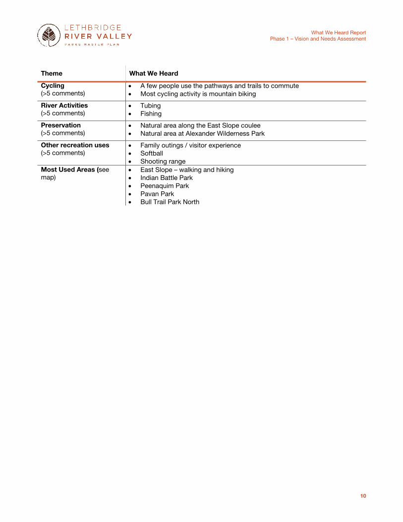
3.2.5 Web Map, Workshop and Open House Comments
Comments from the web map, the workshop and the open house support the survey findings. The web map adds spatial resolution to the input, showing which park areas are more frequently used.
Theme What We Heard
Running / Walking / Hiking (45 comments)
The trail and pathway system is the most commonly used facility / amenity in the river valley
People use the trail and pathway systems for running, walking and hiking The East Slope area is a popular destination for walking and hiking Trail running is popular throughout the river valley
Dogs (>15 comments)
The off-leash dog areas at Peenaquim Park and East Slope are well-used East Slope and Indian Battle Park are popular areas for on-leash walks
Experience (>15 comments)
The river valley is a place for relaxation, quiet and peace The river valley allows people to connect with one another and the natural
world The river valley is a destination for visitors and families
Nature Appreciation (>5 comments)
Elizabeth Hall Wetland is a destination for birding East slope is a destination for viewing plants and landforms (coulee)
What We Heard Report
Phase 1 – Vision and Needs Assessment
10
Theme What We Heard
Cycling (>5 comments)
A few people use the pathways and trails to commute Most cycling activity is mountain biking
River Activities (>5 comments)
Tubing Fishing
Preservation (>5 comments)
Natural area along the East Slope coulee Natural area at Alexander Wilderness Park
Other recreation uses (>5 comments)
Family outings / visitor experience Softball Shooting range
Most Used Areas (see map)
East Slope – walking and hiking Indian Battle Park Peenaquim Park Pavan Park Bull Trail Park North

9
8
7
6
54
3
2
1
0
99
98
97
96
95
94
93
92
91
90
89
8887
86
85
84
83
82
81
80
7978
7776
75
74
72
71
70
69
68
67
66
6563
62
6159
5857
56
55
54
5352
51
50
4948 47
46
45
44
43
42
41
40
39
38
37
36
35
34
33
32
31
30
29
28
26
24
23
22
21
20
19
1817
16
15
13
12
11
10
183
182
181
180178
177
176
175
173
172
171
170
169
167
166165
163
162161
159 155
154151148147145
141140139
137136
134
133
132131129
127
126125
123
122
120
118
117
116
109108
103
0 1 2 3 40.5Kilometres
8
6
5
97
93
82
71
6563
39
30
29
28
27
26
183179
141
140
139138
137
136
135
134
133
124
117
116
109
108
107
106
105
103
102
101
9
1
89
8887
85
84
80
7776
75
69
68
37
36
25
13
174
170
162161160
159 158
156
155
154
153152151
150149
148
147
146145
144
115114
113112
111110
Whoop-Up Drive
Scenic Drive S
5
3
3
25
4Scenic Drive S
Sce
nic
Driv
e N
Crowsnest Highway
University D
rive
University D
rive
13th St N
City Boundary
Roads
‘I Use’ # (Refer to record of comments)
Legend
60 Ave W
4Kilometres
Legacy Ridge
Hardieville
Stafford Dr N
Brid
ge Dr W
Mountain View Cemetary
Lethbridge Country Club
Lethbridge College
Ol
dm
an
R
i ve
r
Nicolas SheranPark
University ofLethbridge
Paradise CanyonGolf and Country Club
St.
Mar
y R
ive
r
S ix Mi le Coul ee
0 0.5 21 3
Alexander Wilderness
Park
PeenaquimPark
BullTrailParkNorth
Elizabeth Hall
Wetlands
Helen Schuler Nature Reserve
Helen Schuler Nature Reserve
BullTrail Park South
Indian Battle Park
Indian Battle Park
Botterill Bottom
Park
East Slope
East Slope
East Slope
Paradise Valley
Paradise Valley
Popson ParkCottonwood
Park
Pavan Park
Online Map Tool‘I Use’

What We Heard Report
Phase 1 – Vision and Needs Assessment
12
3.3 What is Liked
Most of the comments from the web map, the workshop and the open house reinforce and help refine the survey findings:
Most “liked”: It is clear that the pathway and trail system and the natural environment are the two most “liked” features of the river valley. The web map tool adds spatial resolution to the findings, revealing that the East Slope area, Botterill Bottom Park and Indian Battle Park emerge as the most “liked” areas.
Natural Environment: Respondents tend to define the natural environment in terms of wildlife, habitat and landforms (coulees), but do not often refer to the river. It is of interest to note that many respondents make a strong connection between the natural environment and the beauty / experience of being in the river valley, but that fewer respondents articulate the value of the river valley as part of a broader ecosystem. This is important to consider when interpreting survey findings on the functional value of the river valley; although ecological preservation was found to be an important function (65%), it did not appear as a theme or concept when not prompted. This suggests that the social value of being in nature is more important than the ecological value of the river valley within the broader landscape.
Experiencing Nature: Respondents identify that the river valley is a great way to experience nature and all of the benefits it brings. This includes the positive impacts on overall health and wellness as well as gaining an understanding and appreciation of the natural world.
Other/Emergent Uses: Off-leash dog areas emerge as a well-liked feature, as do the bike park, playgrounds and the Helen Schuler Nature Centre. Other passive uses enjoyed in the park include nature appreciation, experiences and family outings, and opportunities to learn about the area’s history.
A summary of the main themes and concepts is provided below.
Theme What We Heard
Pathways and Trails (70 comments)
People like to use the pathways and trails for running and walking Runners enjoy using the single-track, naturalized trails Well-liked trails are enjoyable because they provide good access and
connectivity Some respondents indicated that they use the pathway and trail system to
commute Nature (>60 comments)
People define the natural environment of the river valley in terms wildlife, habitat, and landforms (coulees)
People highly value this natural environment, and like the experience of being in nature
People value the proximity and access to nature provided by the river valley’s central location in Lethbridge
People value the scenic qualities and beauty of the river valley The natural environment should be “preserved” and left “undeveloped”
Asset (>30 comments)
The river valley makes Lethbridge a livable, active and attractive city The city is doing a good job of planning for, and managing, this civic asset
Other Recreation Uses (20 comments)
Nature appreciation and scenic views Picnics and family outings Park areas in general (eg. Indian Battle Park, Popson Park) Learning and appreciation of area’s history

What We Heard Report
Phase 1 – Vision and Needs Assessment
13
Theme What We Heard
Experience (>15 comments)
The river valley is a place of quiet, solitude, peacefulness The river valley is a place to experience nature The experience of being in nature connects people to one another and to
the world around them Facilities / Amenities / Programming (15 comments)
In addition to pathways and trails, people like the following facilities / amenities: Bike park Playgrounds Helen Schuler Nature Centre Softball fields
The shooting range is well-used (Post-it note mentioned ‘>1400 users’) Dog Areas (>10 comments)
Off-leash areas are well-liked Some people want to see more off-leash areas Provide more dog bags and garbage bins in off-leash areas
Best liked areas (see map) East Slope: Pathways and trails for running; preservation / appreciation of natural areas (coulees)
Botterill Bottom Park: Pathways and trails for running; dog park; bike park Indian Battle Park: Range of diverse recreation opportunities Popson Park: Off-leash dog area Peenaquim Park: Off-leash dog area; ball diamonds Pavan Park: Pathways and trails Paradise Valley area: Pathways and trails

9
8
7
6
5
4
3
2
10
99
98
97
96
959493
92
91
90
89
88
87
86
85
84
83
828079
78
7776
75
74
73
7271
70
69
68
67
6665
64
63
62
61
6059 58
57
56
55
54
5352
51
50
49
48
47
46
45
44
43
42
41
40
39
38
37
36
35
34
33
31
30
29
28
27
26
25
24
23
22
21
20
19
18
17
16
15
14
13 12
11
10
107
106
105
104
103
102
101
100
0 1 2 3 40.5Kilometres
4
3
97
86
85
84
83
82
818079
78
66 65
32
25100
6
2
61
56
50
47
43
42
41
40
39
33
29
20
19
18
14
104102
Whoop-Up Drive
5
3
3
25
4Scenic Drive S
Sce
nic
Driv
e N
Crowsnest Highway
University D
rive
University D
rive
City Boundary
Roads
‘I Like’ # (Refer to record of comments)
Legend
60 Ave W
4Kilometres
Stafford Dr N
Brid
ge Dr W
Lethbridge Country Club
Lethbridge College
Ol d
ma
n R
i ve
r
Nicolas SheranPark
University ofLethbridge
Paradise CanyonGolf and Country Club
St.
Mar
y R
ive
r
S ix Mi le Coul ee
0 0.5 21 3
Alexander Wilderness
Park
PeenaquimPark
BullTrailParkNorth
Elizabeth Hall
Wetlands
Helen Schuler Nature Reserve
Helen Schuler Nature Reserve
BullTrail Park South
Indian Battle Park
Indian Battle Park
Botterill BottomPark
East Slope
East Slope
East Slope
Paradise Valley
Popson Park
CottonwoodPark
Pavan Park
Online Map Tool‘I Like’

What We Heard Report
Phase 1 – Vision and Needs Assessment
15
3.4 What Could be Changed
As with what is liked, comments from the web map, the workshop and the open house reinforce and help refine the survey findings:
Pathways and trails: There is strong support for improving the design and maintenance of existing trails prone to washing out from flooding or rain events. There is also considerable interest in creating a connected pathway and trail system that links existing trails and park areas in a continuous loop. There is also interest in creating a pedestrian crossing that spans the top of the river valley.
Natural Areas: There is a strong desire to protect natural areas in the river valley to preserve opportunities for the enjoyment of the natural environment, and to conserve sensitive environmental features. Residential development is the greatest concern as it impacts sensitive landforms (i.e. coulee slumping) and affects enjoyment of the natural environment. Any type of facility development or recreational use expansion will need to consider its potential impacts to sensitive environmental features and to the experience of the natural environment.
Access: Access emerged as an important issue. Many comments indicate the desire for greater universal access to the pathway and trail system. Comments also suggest strong interest in improving access to the river for river-based activities such as paddling, fishing and swimming for dogs.
Use Conflicts: Several existing and potential future use conflicts also emerged. There are concerns that off-road vehicles and industrial gravel extraction are damaging natural areas. There is also some disagreement over the expansion of uses, in particular off-leash dog areas, allowing festival or events-based programming, disc-golf and camping.
A summary of the main themes and concepts is provided below. Detailed comments about improvements in particular park areas are also provided.
Theme What We Heard
Pathways and Trails (>130 comments)
Maintenance and repairs are needed for a number of pathways and trails: Bull Trail Park North Bull Trail Park South East Slope Indian Battle Park Pavan Park
Design resilient pathways and trails that will not wash out from flooding and rain events (eg. consider materials other than red shale)
Improve connectivity: Create a loop around the rim of the park Continuous north-south trail system that connects park destinations Address connectivity issues around the Lethbridge Country Club Edmonton River Valley is a frequently cited precedent Keep pathways naturalized
Expand paved options to improve universal access Land Use (>70 comments)
Limit residential development / encroachment into the river valley, particularly in the Six Mile Coulee area (East Slope)
Protect natural areas in the river valley for habitat, wildlife, open space and enjoyment of the natural environment
Promote reclamation, particularly in areas featuring gravel extraction

What We Heard Report
Phase 1 – Vision and Needs Assessment
16
Theme What We Heard
Protect areas vulnerable to flooding Access (65 comments)
Improve universal access throughout the river valley Improve parking Improve access to the river
More parking for river activities Boat launch and an in/out circulation system Access to the river from the dog parks
Maintenance / Design (>60 comments)
Control the beaver population Control invasive species and weeds Consider bio-control methods for invasive species and weeds Build facilities above the 1:200 year floodplain Address the sewer smell Address littering on trails Address dumping of landscaping waste along coulees
Use Conflict (>60 comments)
Dogs: Provide fencing in winter to prevent dogs from going near the river Mountain biking: negative impacts to ravine system and trails Off-road vehicles: negative impacts to the coulees and trails, particularly
in Alexander Wilderness Park Gravel extraction: incompatible with the natural area Residential development: causes slumping along the coulee Powerline: impacts views of the river valley Treatment plant: too close to softball fields Shooting range: too close to pathways / dangerous
Facilities / Amenities (>55 comments)
Provide a boat launch to improve safe access to the river, both for users and for emergency personnel
Allow camping Don’t allow camping Provide more washrooms and ensure year-round access Provide more garbage/recycling bins Provide water stations Provide weather-protected facilities for community gatherings
Bridge / Connectivity (>40 comments)
Provide a pedestrian bridge to connect Battleship Island to the Golf Course to reconnect pathways
Suggestions for a bridge alignment include: Chinook Connect Scenic Dr and University of Lethbridge (Downtown) –
consider this crossing as a pedestrian bridge that spans the river valley that is easy for people of all ages and abilities to cross
Consider providing a ferry system or a funicular to improve connectivity Recreation Uses (>25 comments)
Increase river-based activities Kayak and canoe rentals Fishing access points
Increase winter activities Cross-country skiing Tobogganing
Allow for trail rides (equestrian) Allow disc-golf Don’t allow disc-golf

What We Heard Report
Phase 1 – Vision and Needs Assessment
17
Theme What We Heard
Dogs (>25 comments)
Off-leash areas in Peenaquim Park and Popson Park are located in rattlesnake habitat and constitute a use conflict
Expand off-leash areas Do not expand off-leash areas Some use conflicts between off-leash area users and runners accessing
trails Improve access to dog bags and garbage bins Ensure that dogs remain on-leash on pathways and trails Provide dogs with access to the river in the summer, but prevent dogs
from accessing the river in the winter Signage / Wayfinding (>15 comments)
Improve signage and wayfinding Maps of walking paths Distance markers Directional markers
Provide more interpretive signs for historical sites of significance and ecological processes
Governance / Enforcement (15 comments)
Develop a monitoring system for environmental and recreational indicators Ensure the park and the plan can change over time Improve enforcement of:
Off-leash dogs Off-highway vehicle use Trespassing
Work with shooting range operator to ensure that any potential transition of uses allows for enough time to plan for transition
Ensure equal representation of perspectives to balance ideas for environmental protection and recreation
Use gender-neutral pronouns for surveys Safety (>10 comments)
Weir is dangerous Insufficient emergency river access Safety concerns due to proximity of shooting range
Programming (>10 comments)
Provide more festival or event-based programming Do not provide more festival or event-based programming Provide family-focused programming
History (>10 comments)
Designate historic sites Provide interpretive signage that focuses on area’s history
Tourism (>5 comments)
Market the river valley as a tourism destination: Views Observatory / star gazing Galt #8 mine
Route signage for tourists
The map below shows areas needing improvement. A table then summarizes key suggestions and frequently heard concerns by park area.

98
7
6
5
43
2
1
0
99
98
97
96
95
94
93
92
91
90
89
88 8786
85
84
83
82
81
80
79
78
77
76
75
74
73
72
71
70
69
68
67
66
65
64
63
62
61
60
59
58
57
56
55
54
53
52
51
50
49
48
47
46
45
44
43 42
41
40
3938
37
36
35
34
33
32
31
30 29
28
27
26
25
24
23
22
21
20
19 18
17
16
15
14
13
12
11
10
195
194193
192
191
190189
188
187
186
185184
183
182
181
180
179
178
177
176
175
174
173
171
170
169
168167
166
165
164
163
162
161
158
157
156
155154
153
152
151 150
149
148
146
145
143
142
141
139
138
137
136
135
134
133
131
130
129
128
126
125
124
123
122
121
120
119
118
117
116
115
114
112
111
110
109
108
107
106
103
102
0 1 2 3 40.5Kilometres
63188
185184
183
182
169
149
120
0
93
89
86
83
76
74
56
52
32192
125
116
106
101
100
98
82
81
54
36
186
181
163
121
111
103
75
7253
5045
44
24
23 20
17
11
177
162
160159
140
139
115
113104
7
97
79
60
5131
26
21
12
194
193
173
164
152
151
150
138
137
110
109
105
Scenic Drive S
5
3
3
Sce
nic
Driv
e N
University D
rive
13th St N
City Boundary
Roads
‘Needs Improvement ’ # (Refer to record of comments)
Legend
60 Ave W
4Kilometres
Legacy Ridge
Hardieville
Stafford Dr N
Brid
ge Dr W
Mountain View Cemetary
Lethbridge Country Club
Lethbridge College
Ol
dm
an
R
i ve
r
Nicolas SheranPark
University ofLethbridge
Paradise CanyonGolf and Country Club
St.
Mar
y R
ive
r
S ix Mi le Coul ee
0 0.5 21 3
Alexander Wilderness
Park
PeenaquimPark
BullTrailParkNorth
Elizabeth Hall
Wetlands
Helen Schuler Nature Reserve
BullTrail Park South
Indian Battle Park
Botterill Bottom
Park
East Slope
East Slope
Paradise Valley
Paradise Valley
Popson Park
CottonwoodPark
Pavan Park
Online Map Tool‘Needs Improvement’

What We Heard Report
Phase 1 – Vision and Needs Assessment
19
Areas Needing Improvement What We Heard
East Slope (>35 comments)
Limit development along the coulee edge Concern about slumping from residential development Use conflict between residential development and nature preservation Poor reclamation in area where bike path was added Some pathways require improved maintenance
Lethbridge Country Club (>15 comments)
Improve pathway connectivity through this area Provide bridge to Battleship Island to connect North and South
Peenaquim Park (>15 comments)
Improve pathway connectivity through this area Provide river access from off-leash dog area Use conflict between nature appreciation and shooting range Use conflict between off-leash dog area and walkers/runners access the
trails Aggregate Area (15 comments)
Use conflict between aggregate extraction and nature preservation Use conflict between sewage smell and softball fields Poor connectivity through this area
Bull Trail Park South (15 comments)
Pathways frequently wash out, and require maintenance and repair The University of Lethbridge is a good location for potential pedestrian
bridge Concern about beavers
Bull Trail Park North (>10 comments)
Pathways frequently wash out, and require maintenance and repair Stairs require maintenance and repair Pathways are dangerous for cyclists as they are too narrow Improve parking Good location for off-leash dog area
Alexander Wilderness Park (>10 comments)
Concerns about littering / dumping Concerns about unauthorized off-road vehicle use Concern about residential development in proximity to the park
Popson Park (>10 comments)
Pave the road to Popson Park Good location for fishing Use conflict between off-leash dog area and snake habitat Need stairs as the slope is steep and ices over
Indian Battle Park (>10 comments)
Provide more garbage/recycling bins, washrooms Some pathways require improved maintenance Protect against flooding
Pavan Park (>5 comments)
Improve access to the river Some pathways require improved maintenance Protect natural features
Botterill Bottom Park (>5 comments)
Improve the aesthetics of the bike park Improve parking and river access Keep washrooms open Improve connectivity
Along River (5 comments)
Poor public access to the river in the south western portion of the river valley (private lands)
Leave the river alone

What We Heard Report
Phase 1 – Vision and Needs Assessment
20
3.5 Internal Stakeholder Workshop Results
Feedback from the internal stakeholder workshop echoed comments received at the public open houses and stakeholder workshop, but with more of an emphasis on education, infrastructure and safety in the river valley. Internal stakeholder input was sought on three areas of enquiry related to the river valley:
How Our Business Unit Uses the River Valley
Challenges and Concerns Related to the River Valley
Suggestions for Improvement
Dominant Uses: The main uses by business units in the river valley relate to infrastructure and maintenance. These uses include work related to roadways, stormwater infrastructure, the water treatment plant, underground infrastructure, and trash storage in the river valley. Research and education were also identified as primary uses, as well as work being done to maintain public safety in the river valley.
Challenges + Concerns: Recognition of challenges and concerns about various issues in the river valley were
relatively widespread, but the most comments recorded related to the environment. Internal stakeholders identified factors such as flooding, erosion, contaminated sites, and a poor history of reclamation as key issues of concern in the river valley.
Suggestions for Improvement: Areas for improvement centered equally upon improvements to access and amenities
in the river valley. Additional water stations, better lighting, bigger playgrounds, parking improvements, and the development of a formal mountain bike area in the river valley were identified as improvements to amenities. Suggestions for improved access revolved mainly around issues of safety. For example, a third bridge and additional access points would allow for greater emergency access.
A summary of the main themes and concepts related to these three areas of inquiry is provided in the table below.
Theme What We Heard
Amenities/Facilities (11 comments)
River valley facilities used for booking personal and community events Lack of infrastructure to support events, such as parking and washrooms Desire for additional water stations Desire for more adequate mountain bike trails Inadequate lighting in parks and safety Desire for bigger playgrounds Desire for more multiple use facilities (seasonal) Inadequate parking - desire for parking improvements
Access + Accessibility (10 comments)
Access to the river valley should be increased or maintained Access could be cut off due to both bridges being closed Concern over traffic flow in the river due to only one way in and one way
out Lack of access to the river for boating and swimming Desire for a third bridge to improve access Wider access roads and trails are needed for emergency vehicle access Multiple access points into the river valley are needed

What We Heard Report
Phase 1 – Vision and Needs Assessment
21
Desire for more public access at key view points at the river valley edge Desire for formal mountain biking lands within the river valley
Education (4 comments)
River valley used for educational and historical activities Helen Schuler Nature Centre River valley as an outdoor classroom
Enforcement (5 comments)
Monitoring encampments Designated environmental reserve regulation Concerns about dogs off-leash Concern for negative uses, such as straying from formal trails and littering Fire bans
Environment (10 comments)
Flooding and drought in the river valley Bank erosion and stability Poor history of reclamation work in the river valley Contaminated sites in the environmental reserve Fire and vegetation control
Infrastructure + Maintenance (13 comments)
Infrastructure that is used by business units in the river valley Water Treatment Plant and Wastewater Treatment Plant are important
facilities Roadways within the river valley and those used to access the river
valley Underground infrastructure Closed landfills for trash storage
Access to infrastructure (e.g. stormwater outfalls) is an issue Boat launch needs to be maintained
Governance (4 comments)
Need for a common vision Work more collaboratively with the County
Pathways + Trails (3 comments)
Concern that trails do not connect end to end Desire for smoother paved pathways Need for pathways to loop and connect with others
Recreation Uses (9 comments)
Need for adequate mountain bike trails Add and promote alternative uses Used for social functions Used as a gathering space for family events Used for sports tourism Used for nature based recreation and leisure
Research (4 comments)
Assessments conducted regularly in the river valley Geotechnical assessments conducted Slope stability studies conducted Research sites within the river valley
Safety (9 comments)
Safety related uses of the river valley include: Search and rescue Arrests and law enforcement Assets and liability management K-9 Fan Run Canine Recruits
Safety concerns related to: Drug deals Inadequate lighting Need for call boxes Crime Prevention Through Environmental Design (CPTED)
Use Conflicts (8 comments)
Need to balance passive and active recreation Human/wildlife interactions

What We Heard Report
Phase 1 – Vision and Needs Assessment
22
3.6 Summary
The Lethbridge River Valley is a strong civic asset that is well-used by residents, particularly in the summer, fall and spring. Users value the river valley landscape, the pathway and trail system, and the myriad opportunities to be in nature. Many also see the river valley as a significant civic asset.
Future desires for the river valley include a better connected pathway and trail system, and for better trail design and maintenance to stop trails from washing out. There is concern about "over development" of more natural areas (Popson, Alexander Wilderness Park), both in terms of expanding active recreation uses and residential encroachment into the river valley. Demand for better river access in terms of parking and safer boat launches is also quite prominent.
It is also instructive to consider potential areas of tension that may need to be reconciled through additional research, analysis and policy development, as well as further discussion in subsequent phases of engagement. These include:
Pathways and trails
o Better maintenance of existing trails may conflict with the desire to add new trails to connect the system, both in terms of prioritization and potential impacts resulting from trail development.
o The decision to build naturalized or paved trails may also present a conflict. Runners and many nature enthusiasts prefer naturalized trails because it provides variety of exercise and because better for the environment. Others would like to see more paved trails to improve universal access and safety.
Dogs
o Addressing safety and environmental concerns about snake habitat in off-leash area
o Addressing the use conflict between off-leash dogs and runners
o Addressing the use conflict between dogs and nature preservation
Balancing nature preservation with mountain bikers (generally considered a permitted use) and with off-highway vehicles (generally considered a non-permitted use)
There is disagreement over the expansion of current and future uses. These include:
o Expansion of off-leash dog areas
o Allowing festival or events-based programming
o Allowing disc-golf
o Allowing camping
Land use conflicts around residential development and natural preservation. Concerns exist about development on the top of bank both from a viewshed / nature experience perspective (i.e. developing encroaching upon the view of people in the valley and enjoyment of being in nature) and from its environmental impact on the valley. Further development could promote slumping and may increase pollution entering into the valley.
Conflicts between human use and wildlife resulting in reduced connectivity and increased habitat fragmentation
Concern that the shooting range conflicts with neighboring uses Commercialization of the area reduces connectivity and access and
conflicts with wildlife and the natural environment.

What We Heard Report
Phase 1 – Vision and Needs Assessment
23
The potential for tension arising from management or policy decisions that prioritize different social and ecological functions of the river valley. This tension manifests as a values-based issue between environmental conservation and enjoyment/experience of being in nature and non-developed open space. Adding complexity to this issue, it can be somewhat difficult to define the latter as people experience nature differently. While these two values can often be complimentary, there are instances where they could be divisive, such as the expansion of a more accessible pathway system and the maintenance of natural areas. Moving forward, it is important to be clear about how best to preserve the natural integrity of the valley, while balancing expectations around how a natural area looks and feels from an experiential perspective.

What We Heard Report
Phase 1 – Vision and Needs Assessment
24
4. Next Steps
Results presented in this report will be incorporated into the State of the Valley report. The State of the Valley report will be the basis for the development of a concept and management recommendations for the Lethbridge River Valley Parks Master Plan. The concepts will then be presented to the public for review and comment.

What We Heard Report
Phase 1 – Vision and Needs Assessment
25
Appendix A: Record of Comments
The tables below provide a record of comments from the public and stakeholder workshops as well as the internal stakeholder workshop held with staff.
4.1 Public and Stakeholder Workshops
Table 2. Public and Stakeholder Comments – I Use the River Valley for...
Comment Theme Sub-Theme
Play at Fort Whoop-Up. Could we camp? Amenities
1,600 users [Shooting range] Amenities
Target shooting - training - competition Amenities Programming
Softball Valley 350 people per night APR-OCT Amenities Programming
I golf here with my familly :) Amenities
Spending time with grandkids Governance
3 National Historic Sties in Indian Battle Park - Port Whoop Up; Belly River Battle; High Level Bridge History
I do photography all over the valley Nature Appreciation
star gazing Nature Appreciation
Rena Woss Oldman River Observatory 317.3129 Nature Appreciation
Popson Park - Oldman River - Observatory - a word class centre *tourism *Protect the vast night skies Nature Appreciation
Off-leash park at Peenaquim Park is complementary to the Shooting range Off-leash dog park
We (300+ runners) run + train year round on the rough trails from 6 mile to Pavan Pathways and Trails
I use and love the running trails here [Botterill Bottom/East Slopes] Pathways and Trails
I commute by bicycle from W. Lethbridge to downtown via UofL trail -> Whoop-Up pedestrian bridge Pathways and Trails Active Transportation
Walking Hiking [west of Lethbridge in the river valley] Pathways and Trails
I use it almost every day! (The City cleared primary paths of snow on Saturday, THX!) Pathways and Trails Maintenance
University - that's where the cyclists are! Pathways and trails
Walking / running pathways Pathways and trails
trails - I walk here, Bike paths - I ride here Pathways and trails
Bicycle [Botteril Park] Pathways and trails
Walk [Helen Schuler Nature Reserve] Pathways and trails
Cycling, running, walking, paddling, photos Recreation
I use the gun range & occasionally softball valley Recreation
I use Helen Schuler Nature Centre. I also enjoy various run/walk events such as moonlight runs & bare bones run un river bottom Recreation

What We Heard Report
Phase 1 – Vision and Needs Assessment
26
Trail running; biking; kayaking; wildlife! Recreation
Picnic Recreation
I use the valley to float on the river : pull-in at the water treatment plan and take out at Pavan Park (long route) or at Hwy 3 (short route) River activity
Floating/ rafting River activity
The coulees are wonderful to see Scenery
2 hibernalula [near Bridge Valley Golf Course] Wildlife
Tobogganing at Sugar Bowl is very popular! Winter activity
There is a lot of all year round cyclists in Lethbridge Winter activity
Table 3. Public and Stakeholder Comments – Why I do not Use the River Valley Today...
Comment Theme Sub-Theme
No toilet at Botterill boat launch Amenities
No take out at Pavan! Boat Launch
Silting in at boat launch Boat Launch Maintenance
Cleaner water! Environment
There is constant dust and noise coming from the Tollestrud sand and gravel operation Environment
The constant aroma drifting from the City of Lethbridge sewage lagoons is quite horrible!! Environment
City of Lethbridge asphalt recycling plant environmental nightmare (smell, air polution) Environment
Acquire private lands Ownership
Love - Picnics; photography, birdwatching, walking * quiet place to go Recreation
Because I will die on the weir while kayaking Safety
It is covered with snow Seasonal

What We Heard Report
Phase 1 – Vision and Needs Assessment
27
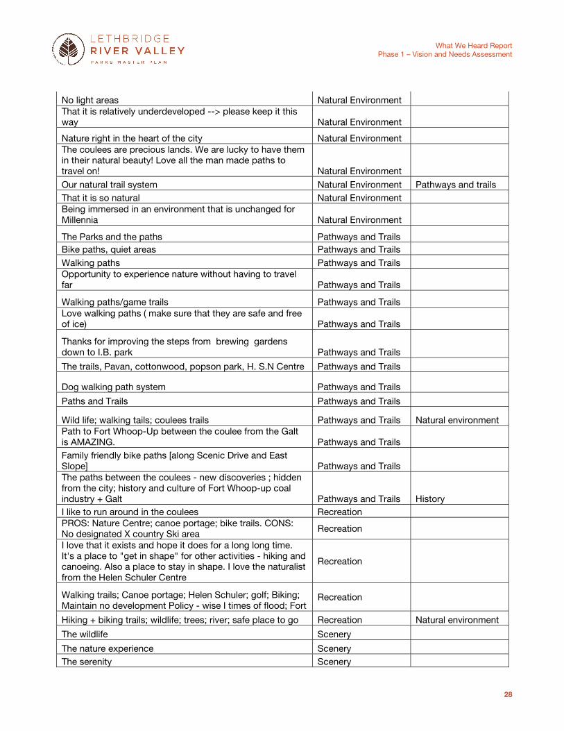
Table 4. Public and Stakeholder Comments – What I like about the River Valley is…
Comment Theme Sub-Theme
It's free for all users Accessibility
Easy access at multile points Accessibility Pathways and trails
I like the group events at at Fort Whoop-UP Amenities + Facilities
off leash dog run Amenities + Facilities
Great amenities and facilities Amenities + Facilities
Picnics in the Baroness Shelter Facilities
Kudos for Helen Nature Centre Education Helen Schuler + the great stadd that eagerly want us to increase our use of the valley Education
When the river valley is green Environment Green space forever. Leave Cotton wood park as natural as possible Environment Love all the trail development. Prefer "rough" trails to paved though Environment Love Nature centre - supports natural areas awareness and conervation Environment
Medicine stone History Fort Whoop-Up Activities, Indian Battle Site, Our History; our story to tell History Fort Whoop -Up and its preservation and education of our rich history History
Helen Schuler Centre; Historical features; picnic areas History
Being close to wild animals - free and safe Natural Environment The quietness; the minimal development; the year round access - because the paths are ploughed; decant restrooms; some measure of security due to staff around in early mornings; nice picnic tables close to parking
Natural environment
Seeing the deer Natural Environment Peace + quiet and the wildlife. Get some bylaw enforcement down there. Or all of it will be gone!! Natural Environment
The peacefulness Natural Environment
The nature of the coulees Natural Environment
Prairie flowers and natural grasses Natural Environment
Wildlife Natural Environment
The escape to wilderness on our valley trails Natural Environment
Undeveloped nature Natural Environment
Undeveloped nature! Real nature - in the city!` Natural Environment I love that for the most part it is underdeveloped; there is access to it from so many areas Natural Environment
The escape to wilderness on our valley trails Natural Environment
The tranquillity of the River bank Natural Environment
Running and racing on underdeveloped trails Natural Environment Pathways and trails In the bottom between the coulees the city disappears and you can be all alone Natural Environment
What We Heard Report
Phase 1 – Vision and Needs Assessment
28
No light areas Natural Environment That it is relatively underdeveloped --> please keep it this way Natural Environment
Nature right in the heart of the city Natural Environment The coulees are precious lands. We are lucky to have them in their natural beauty! Love all the man made paths to travel on! Natural Environment
Our natural trail system Natural Environment Pathways and trails That it is so natural Natural Environment Being immersed in an environment that is unchanged for Millennia Natural Environment
The Parks and the paths Pathways and Trails Bike paths, quiet areas Pathways and Trails Walking paths Pathways and Trails Opportunity to experience nature without having to travel far Pathways and Trails
Walking paths/game trails Pathways and Trails Love walking paths ( make sure that they are safe and free of ice) Pathways and Trails
Thanks for improving the steps from brewing gardens down to I.B. park Pathways and Trails
The trails, Pavan, cottonwood, popson park, H. S.N Centre Pathways and Trails
Dog walking path system Pathways and Trails
Paths and Trails Pathways and Trails
Wild life; walking tails; coulees trails Pathways and Trails Natural environment Path to Fort Whoop-Up between the coulee from the Galt is AMAZING. Pathways and Trails Family friendly bike paths [along Scenic Drive and East Slope] Pathways and Trails The paths between the coulees - new discoveries ; hidden from the city; history and culture of Fort Whoop-up coal industry + Galt Pathways and Trails History I like to run around in the coulees Recreation PROS: Nature Centre; canoe portage; bike trails. CONS: No designated X country Ski area Recreation I love that it exists and hope it does for a long long time. It's a place to "get in shape" for other activities - hiking and canoeing. Also a place to stay in shape. I love the naturalist from the Helen Schuler Centre
Recreation
Walking trails; Canoe portage; Helen Schuler; golf; Biking; Maintain no development Policy - wise I times of flood; Fort
Recreation
Hiking + biking trails; wildlife; trees; river; safe place to go Recreation Natural environment
The wildlife Scenery
The nature experience Scenery The serenity Scenery

What We Heard Report
Phase 1 – Vision and Needs Assessment
29
The trees Scenery The scenery and the views Scenery
Softball valley possible one of the " nicer parks" in area Scenery The plants, birds, Helen Schuler Nature Centre, the river Scenery
Natural plants (crocus, prickly pear in particular) Scenery
Elizabeth Hall wetlands Scenery
Appreciation of Nature in our backyard!! Scenery
It’s a scenic getaway in our own backyard Scenery
Great views - Pelicans, etc. - water - landscape Scenery Natural environment The coulees are stunning, public gathering places. I like the decision to keep development out. Historic Interpretation sites are important
Scenery / History
Mountain scenic entrance into the City's Valley along Scenic Drive
Scenic
Opportunity to show guests / tourists the beauty / history / nature of this area Tourism
Table 5. Public and Stakeholder Comments – I Wish the River Valley Could…
Comment Theme Sub-Theme
River access @ Monarch w blood Tribe interpretation Access
We Do need another bridge. Last year I was stranded on the South side for 2 hours. As both bridges had accidences. Hospital access is important
Accessibility
Safety
we need a 3rd river crossing; hospital + emergency ; 2 bridges too backed up!
Accessibility Safety
Great opportunity now! Need better connections for commuting Accessibility Connectivity Design trails + access for 8-80 average (handrails rest landings) Accessibility
Better and more small parking areas - with maps Accessibility Parking Have a good Parking lot / short trail to the river on the north end so that those of us who Kayak, Canoe, Stand up paddle board, Tube down the river can easily get out without damage to the coulees
Accessibility
Need an adequate multi - use crossing @ highway 3 Accessibility
Connect from end of Helen Schuler to the West side (near golf course)
Accessibility Pathways and Trails
Connection between Popson Park and Paradise Canyon Accessibility Pathways and Trails
Ferry across Old Man (self -pull as in the old days) Accessibility
The river valley should not be only for dogs, runners and bikers. We have citizens on wheel chairs, perhaps a facility that serves nice cream or refreshments may help
Accessibility

What We Heard Report
Phase 1 – Vision and Needs Assessment
30
Comment Theme Sub-Theme Would it be possible to establish a continuous path along the river valley with various access points for the different residential areas along the way? ( i.e.. Medicine Hat Calgary style paths)
Accessibility
Pathways and Trails
More wheelchair access for the trails Accessibility
A better boat launch, maintained better Accessibility
More parking at Popson down by the water Accessibility
better landing below weir for canoeing, boating etc. Accessibility
Have improved river access. Improved portage @ weir, Access @ Popson, weir, bridge parking lots.
Accessibility
"Maintain and develop natural trail, w/ secure bridges for trail runners, hikers and cyclists." + make it family friendly - not just extreme trails
Accessibility
recreation
Connection of system from North and South and vice versa Accessibility
How about a bus route? Accessibility
Cycling trails in bottom of river valley on both sides connecting all the parks
Accessibility Pathways and Trails
Oldman river should not be only for young men. We have a lot of older citizens with disabilities that want to enjoy it as well
Accessibility
Put a "cheap" bridge to island by gold course. Let it wash out if another flood, would make a nice continuous path for walkers, cyclists, runners
Accessibility
Pathways and Trails I would like to see a way to get to where the old railway crossed the St Mary river South of Lethbridge. I would also like to see markers at six mile coulee, and all the way to the river bottom. I would be willing to volunteer. John L. Kunty 394-9560 at the View
Accessibility
Wheel chair accessibility Accessibility
More accessibility - more parking Accessibility
Access + signage "welcome to RV" Accessibility
Pedway on high level bridge Accessibility
Botterill park -> sugar bowl-> build a permanent bridge (x2) to island to complete the pathway system
Accessibility
Parking Accessibility
More connections from north and south Accessibility
Better / more accessible entry points and parking Accessibility
have continuous trails the length of the valley, uninterrupted by gravel pit
Accessibility
continuous trail needs a footbridge up stream near country club (south)
Accessibility Pathways and Trails
Provide more river access points to use the river Accessibility
University that's where the bike users are Accessibility
What We Heard Report
Phase 1 – Vision and Needs Assessment
31
Comment Theme Sub-Theme
A lot of all year round cyclists Accessibility
Would love to see a pedestrian bridge across the valley that is high enough to reduce steepness
Accessibility
New bridge would make Lethbridge a destination for retirement Accessibility
Bike & Pedwaybridge - need new crossing; handicap accessible; opportunity for target in 2017?
Accessibility
Need more options for handicap accessibility Accessibility
Complete the "loop" Accessibility Bridge (pedway) location #2 connect at Scenic Drive from U of L Accessibility Need some alternate route signage for long distance cyclists (can't use Hwy 3) [at intersection of Hwy 3 and University Dr]
Accessibility
Fireworks event @ highline bridge Amenities
More garbage cans [by the U of L] Amenities + Facilities Maintenance Keep this area clean for family use. The playground attracts families but the areas around it are awful. [Indian Battle Park]
Amenities + Facilities Maintenance
Overlook from London Neighbourhood Road (overlooking fantastic river valley + University) would be fantastic!
Amenities + Facilities Scenery
wagon rides; rent-a-horse; trail riding Amenities + Facilities
Picnic shelters, elks, John Martin; shield the light; needs more designated parking
Amenities + Facilities
Relocate the police range for (RV camping or overnight car/tent) Amenities + Facilities Camping and
Shooting Range
Wi-Fi the area Amenities + Facilities
More "No Trespassing" Signs out up and maintained Amenities + Facilities Need more camping site / campgrounds (RV and tenting sites) Amenities + Facilities Tourism
Need washrooms available year round Amenities + Facilities Provide attractions/facilities for tourists/ lord families + guests Amenities + Facilities
water stations Amenities + Facilities
Provide more facility for community gathering (not weather sensitive)
Amenities + Facilities
Build toilets at boat launch Amenities + Facilities
Overnight camping Amenities + Facilities
more opportunities for large event use Amenities + Facilities Be more accessible for camping and other tourism activities Amenities + Facilities
event facility at fort Amenities + Facilities
Train rides over high-level bridge Amenities + Facilities
Need more camping sites; RV; tenting Amenities + Facilities

What We Heard Report
Phase 1 – Vision and Needs Assessment
32
Comment Theme Sub-Theme CP Rail could organise train rides across High Bridge to Stirling Amenities + Facilities
Would like to see more dog bag dispenses entering the "back country" areas
Amenities + Facilities
Supply more garbage cans in the University + College parking lots to prevent garbage blowing into the coulees
Amenities + Facilities
Permaculture; food forests; living orchards; free food Amenities + Facilities
Community Garden Amenities + Facilities There could be a seasonal concession stand near nature centre Amenities + Facilities
Increased use in festivals Amenities + Facilities
"Increased use in festivals" - NO!! Amenities + Facilities No motorized 24-7 access/use; dog run/make a dog exercise park; trails, rds., etc. capable for competition xcountry
Amenities + Facilities Recreation
"dog run/make a dog exercise park; trails, rds., etc. capable for competition xcountry" - NO!
Amenities + Facilities Recreation
Provide off leash areas along a river valley trail system Amenities + Facilities
More off leash areas Amenities + Facilities
Play at Fort Whoop-Up. Could we camp? Amenities + Facilities Education
more art instillations historical marks Art History
Public art points - 7A Ave; Scenic Drive 4h St. Art
Control the beavers! - They are out of control! Beavers
TOO many beaver losing too many trees!! Beavers
"TOO many beaver losing too many trees!!" - protect the trees as they do so well in Calgary - Bow trail path system
Beavers
Control the beaver population by the university Beavers
Safe river access that can be accessed from the Valley Road through Peenaquim Park [by off-leash park]
Boat launch
Boat launch always to salty to get a boat in [by water take in] Boat launch
Better location for new boat launch [ south of High Bridge-east bank]
Boat launch
Need study to determine best places for boat launch Boat launch
Need a small boat, easy to take out, launch in Pavan Park Boat launch
Need study to determine best places for boat launches Boat launch
Better location for new boat launch [ south of High Bridge-east bank]
Boat launch
Boat launch always to silty to get a boat in [by water take in] Boat launch
Need (easy) small boat take out in Pavan park Boat launch Need trail to connect (cycling) UofL to trail system down to Popson Connectivity

What We Heard Report
Phase 1 – Vision and Needs Assessment
33
Comment Theme Sub-Theme
Coulee terrain is too rough for alternate trail connection (replacement for washed out trail) [East Slopes between Country Golf Course and Scenic Drive]
Connectivity
Natural Environment Bridge (pedway) location #2 connect at Scenic Drive from U of L Connectivity Bridge
An educational opportunity for our youth Education History
Interactive playground Education History
More interpretive programs for less developed park areas - Pavan, Popson, Alexander
Education
More designated / marked sites of significance Education
Signage to Helen Schuler Nature centre + Elizabeth Hall wetlands should be enhance
Education
Layered online/paper/signed written historical interpretation --> self guided tours markers digital guides
Education
more interpretive signs outside Helen Schuler, provide info on importance/role of Oldman River
Education
become interpretive centre for Fort Whoop up + belly river battle as well
Education
sign about red shale paths Education
have a map of walking paths Education Pathways and Trails
maps showing all trails and amenities' Education Faculties / Amenities Be informed and sensitive to good nocturnal lighting; practice - protect our environment ( birds, trees, all living things) + night sky - we have a 1 St class observatory at Popson Park and need to have skies protected from light pollution
Education
Have better info on use (e.g.. How many residents use the river valley? For what purposes?)
Education
welcome tourists and visitors Be "fire smart" Education Tourism
Have more directional signage Education
Be fenced properly so adjacent landowners won’t have to worry about trespassing + garbage
Education Maintenance
Distance sign 1K - 2K - 3K Education Be protected by the wisdom of those who have intimate (meaningful) relationships knowledge e.g.. Helen Schuler, Liz Hall, ria LNS, SAGe, Graeme Granlee..Becky cousins
Education
Popson Park: Need for more / better signage to ward dog owners of rattlesnakes (left side of parking lot on coulees)
Education
Galt # 8 mine: One of the last best examples of a "tipple" in Canada Education History
Idea for enforcement: In lieu of fire, people must take an education course
Education

What We Heard Report
Phase 1 – Vision and Needs Assessment
34
Comment Theme Sub-Theme
Poor enforcement of off-leash use in Cottonwood Park (and elsewhere)
Enforcement
Trespassing onto private property next to Cottonwood is problematic.
Enforcement
Enforce restrictions on ATV use in wilderness areas Enforcement Natural Environment
Need more by law enforcement Enforcement
Enforce no-dog rule in E.H.W. Enforcement
Manage / Include campsites / motor homes etc Enforcement
"No motorized 24-7 access/use" Enforcement
Better distribution of washrooms facilities Facilities
Protection of city assets within the river valley: Berming required to protect from flooding and fear of flooding. Capital impact: cost of repairs/cost of moving collections/storage of collections/setting up again. Operational impact: loss of revenue/lost of customer confidence.
Flooding protection
Tourism
Helen Schuler Nature Centre Protect with berming Flooding protection
Business plan: Needs to be information flow between 1) Fort Whoop-Up 2) Parks planners 3) Debb Lucas-Swizer/Berrg Bech 4) Tourism committee to ensure compatibility between business plan and parks plan
Governance
Tourism
Helen Schuler and Fort be "grand-fathered' Governance
Be wild for my grand kids + great grand kids Governance
The crowd here is over represented by the granola + Prices crowd who want to keep everyone else out of the park
Governance
don’t allow dogs in nature park Governance
"don’t allow dogs in nature park" - how will you ever make the rules stick
Governance
I hope to spend time in the River valley with grand kids - like I did with our kids
Governance
Provide family centric activities to bring families back for repeat visits
Governance facilities' / Amenities
Change overtime,, (why is all this valuable feedback without source of wisdom?)
Governance
Enforce restrictions on ATV use in wilderness areas Governance Potential land purchase by City [west of Elizabeth Hall Wetlands] Governance
NO further housing development [East Slope] Governance
Conservation easements for 30 m of river shore Governance

What We Heard Report
Phase 1 – Vision and Needs Assessment
35
Comment Theme Sub-Theme There should be a coulee/valley rim trails- the city is dedicated to building right up to the edge - does not make a pleasant walk if one hand is against someone's fence or window
Governance
No more paradise canyons! Governance
Have more proactive definition of lands that are or should be part of the parks/reserves (e.g.. Lands near Tudor estates, other orphan FUD parcels
Governance
Galt # 8 mine: One of the last best examples of a "tipple" in Canada History
Fort Whoop-Up: Town needs to designate historic History
Battle Site be a designated "Historic Site" with Fort Who-Up as the "Interpretive Centre" (and maintain other site or make them signage)
History
Designate Historic Sites ie. Great Indian Battle, Medicine Stone History
More credit to the early mining era. Plaques + monuments History Signage
even more history and culture tours from the Galt/ Fort Whoop-Up. Either guided or signage / brochures; Coal banks - coal mines?; Battle of Belly River
History
Info History points of our city History Tourism
Fort Whoop-up - town needs to designate historic History
Show off local history History Education
Move Tollstrup out of valley noise pollution, dirty , etc., take berm down that they don’t have permission to have
Infrastructure Governance
Storm water into 6 mile? (only natural) coulee creek in Lethbridge Infrastructure
Gravel bed instability problematic for EMS (sitting) [Popson Park east of boat launch]
Infrastructure
Odor problem at the trail by the UofL below parking lot (sewage) Maintenance
Please replace or repair the stairs below Ridgewood. Not in good shape! I broke my ankle there last year!
Maintenance
In general need more maintenance on trail Maintenance
Get ride of the off leash areas so were are not walking in dog poop. Mow around the picnic tables and shelters so our kids can play around after we picnic there. There is still plenty of nature space. Promote the nature center's vision + mission so more people know about the parks and how to use them properly. Connect the 8 parks with a trail system otherwise leave it alone. its perfect and basically unspoiled. The floods take care of renewing it from time to time
Maintenance
Better maintenance of paved trails Maintenance

What We Heard Report
Phase 1 – Vision and Needs Assessment
36
Comment Theme Sub-Theme
Clean up around picnic tables+ shelters; i.e.. Cut the grass and weeds regularly
Maintenance
Make it easy to maintain in case of floods, slumping, etc. Maintenance
Shale trails should be built with proper drainage to reduce long term maintenance issues
Maintenance
Develop a group of volunteers to maintain Aspects of the River Valley. I'm ready Maintenance
Controlled mowing; more garbage bin; maintain healthy rattlesnake dens + overall environment in which they are Found!; enforce park gate closures; limit colouee edge development; road signage
Maintenance
Accommodate facility expansion above the river valley flood level (1:200 yr.)
Maintenance
Have trail maintenance Maintenance
flood and fire protection Maintenance
Have Prescribed fire and grazing ( to mimic natural processes that maintain nature plant communities)
Maintenance
Security gates for parks should be locked and supervised Maintenance Safety
Thoughts given to treatment of storm water before it reaches river?
Maintenance
Water poll - in water treatment Pavan Park ( long). (start) Hwy 3 Maintenance
Protect visual corridors especially HWY 3 Scenic dr. -- Need to clean up
Maintenance
Need to preserve old coal mining building site - develop tourism attraction interpretive site
Maintenance History
Coal mine closed in 1957: potential to preserve buildings as historic features; interpretive
Maintenance History
Trails to University needs improvements (after flooding) Maintenance
Cut old beaver proofing Wires - trees outgrowing them Maintenance
Can the sewage lift by the U of L be modified to eliminate or reduce the strong odor along the main rail
Maintenance
Regenerate Maintenance Have a system for collecting and storing data on key indicators of ecosystem health, rare species, weed distribution.., and use to monitor progress and for adaptation management
Monitoring
Keep this area undeveloped [East Slopes, east of Lethbridge Country Golf Course]
Natural Environment
Sturgeon spanning habitat (reason for not rebuilding trail across island) [ Battleship Island by the Country Golf Course]
Natural Environment

What We Heard Report
Phase 1 – Vision and Needs Assessment
37
Comment Theme Sub-Theme
Identify the corridor that passes by Helen Schuler as a specific use. Enforce
Natural Environment Enforcement
More enforcement & protection for wilderness areas and Six Mile Coulee. More nature, less pavement
Natural Environment Enforcement
Why is construction equipment here? Stop doing it unless essential [east of the weir, on island]
Natural Environment
Stop vehicle traffic in the coulees Natural Environment Enforcement
Dump area [by the RV Resort] Natural Environment Maintenance
Stop wrecking the coulees to make room for roads for cars! [by gravel pit and waste water treatment plant]
Natural Environment
Off-leash dog park in rattlesnake habitat - Compatibility issues Natural Environment
Peenaquim Park is a bull snake habitat. Off-leash dog park is not compatible.
Natural Environment
Popson Park: Need for more/better signage to warn dog owners of rattlesnakes [left side of parking lot on coulees]
Natural Environment Signage / Off-leash dog park
Wildlife birds, deer, cacti + plants grasses -1 % or less of CDN Natural Environment
Off leash dog walking areas -- Not in rattlesnake habitat Natural Environment Off-leash Dog Area Helen Schuler Nature Centre a vital Piece (protect it from flooding) Natural Environment
Protect our wildlife - including snakes Natural Environment
Low level of facility development that allows for natural processes (e.g. flood, erosion)
Natural Environment
Keep it Natural! Natural Environment
Keep the park as natural as possible Natural Environment
Deal with weeds and invasive species in particular (wormwood?) Indian Battle Park
Natural Environment
Retain the natural aspect of the river valley Natural Environment
remain untouched!! Natural Environment
"Include a disc golf course as per Include a disc golf course as per --> IN a nature reserve???
Natural Environment
Do not over develop, its great as it is! Natural Environment
Remain underdeveloped grass lands + nature Natural Environment
Preserve Natural Setting Natural Environment
Reclaimed river banks!!! Natural Environment
Keep as natural as possible. Not all areas need to be accessed by all!!
Natural Environment
Some development, but please keep it as natural as possible Natural Environment
I wish the river valley could remain mostly unchanged in the area between ft. way and Helen S.
Natural Environment

What We Heard Report
Phase 1 – Vision and Needs Assessment
38
Comment Theme Sub-Theme
Protect the existing bio diversity Natural Environment
Keep it natural with lots of animals + birds Natural Environment
Let's keep development like what is proposed in Tudor Estates - OUT!!
Natural Environment
Have more control of invasive non- native species (leafy spurge, knapweed, Russian Olive, absinthe..)
Natural Environment Maintenance
continue to be home for wildlife Natural Environment
be left as natural as possible - we have 4,000 acres, 16 km of parkland - let’s not mis-manage this system
Natural Environment
Retain some natural areas for nature preserve and allow appreciation of the natural environment
Natural Environment
more public space on coulee edge / top of bank less private residential
Natural Environment
Create a greater opportunity for people to get away from artificial lights - enjoy a "natural" night sky + quiet
Natural Environment
Fort Whoop-Up sprays for spurge Natural Environment Maintenance
Popson Park - Oldman River - Observatory - a word class centre *tourism *Protect the vast night skies
Natural Environment Scenery
Biocontrol of Weeds Natural Environment
Control the beavers they are taking down the trees Natural Environment
Filling the oxbow to provide for trail access at golf course Natural Environment
Sports Recreation opportunities in a beautiful environment - by HWY 3 entering the city
Natural playground
Whoop-Up parking on special event days (1,600+/day) Parking Programming
Lack of parking prevents usage (for large events) [Bridge Valley Golf Course]
Parking Programming
Extend park south on east side, at least to a point across from Paradise golf course
Parks
Be expanded to include lands north of Pavan Park (beautiful cotton wood forest on flood plain) at risk from gravel extraction
Parks
80 acres of land a the old Galt #8 mine; ideal for park Parks
Fenced in tunnel for pathway connection next to golf course (like Calgary Zoo) [west side of Country Golf Course along river and Battleship Island]
Pathways and Trails
Safety
Simple bridges needed to connect to island to trails. Trail needs to be replaced.
Pathways and Trails Connectivity
Trail connecting the UofL needs improvements. It is destroyed again!
Pathways and Trails Maintenance
Paved trails need to be clean up (cover in mud) Pathways and Trails Maintenance

What We Heard Report
Phase 1 – Vision and Needs Assessment
39
Comment Theme Sub-Theme
Need for better education + signage so people understand why not to go off trail
Pathways and Trails Enforcement and Education
Pathway along floodway near gravel plant would connect North & South Parks. Ideal location.
Pathways and Trails Connectivity
Need better connection between Bridge Drive path and pedestrian bridge. Currently have to off-road.
Pathways and Trails Connectivity
Need pedestrian connectivity to south in Lethbridge County along St. Mary's River
Pathways and Trails Connectivity
Coal Bank trails need to be continuous Pathways and Trails Connectivity
Find a way to connect ''Sugar Bowl" path pas Country Club heading north
Pathways and Trails Connectivity
The south path needs to be connected to the other path in the north [East Slopes, along river]
Pathways and Trails Connectivity
Gap in paved trail along Scenic Dr Pathways and Trails Connectivity
Link up bike paths between Pavan and South of Bridge Dr Pathways and Trails Connectivity
Integrate into trails/urban parks system [Six Mile Coulee east of Highway 5]
Pathways and Trails Connectivity
Bridge to/from Island [Battleship Island by the Country Golf Course]
Pathways and Trails Connectivity
Connection needed! [Battleship Island by the Country Golf Course] Pathways and Trails Connectivity
Mow the trail [Cottonwood Park[ Pathways and Trails Maintenance
Fix the bike/walk path up to the U of L Pathways and Trails Maintenance
Paved - Primary, Dirt - Secondary, Multi-use path system. Establish longer "loop" (Full valley loop)
Pathways and Trails Connectivity
Connect pathway from Scenic Dr N to North end of Indian Battle Park
Pathways and Trails Connectivity
Pedestrian /bicycle comfortable and safe crossing needed at Hwy 3 [by RV Resort]
Pathways and Trails Connectivity
Can't go past parking lot on bikes at Alexander Wilderness Park Pathways and Trails
Integrate trails contiguous to AB trail to Lethbridge [near highway 3]
Pathways and Trails
No more paved trails. Leave it natural Pathways and Trails Natural Environment
appreciate asphalt rail in river valley for cycling Pathways and Trails Recreation
Continuous trail from Bottlerill to Pavan Pathways and Trails Connectivity
Would like to see informal trail as they are - nice for running Pathways and Trails
Complete the Sugar Bowl loop to Botterill Park Pathways and Trails Connectivity
Connecting six mile coulee with larger river valley through pathways and trails
Pathways and Trails Connectivity
Grade too steep. Need at grade crossing here for kids. Pathways and Trails Accessibility

What We Heard Report
Phase 1 – Vision and Needs Assessment
40
Comment Theme Sub-Theme
New Mt. Bike venue Pathways and Trails Mountain Biking Walking trails ; bike paths (need more connectivity north -south) Pathways and Trails
No bike trails through Alexander wilderness park Pathways and Trails
We need a bike trail through Alexander wilderness park Pathways and Trails
Restore pathway lost to flooding along the Country Club area - Store the continuity of the pathway
Pathways and Trails
Westside Trail development and connection please Pathways and Trails
Nature Centre and Peenaquim park need a connecting path Pathways and Trails Accessibility
Have more Neighbourhood walking trails Pathways and Trails
I would like the river trail to connect through the golf course Pathways and Trails
I would like access to the river in the area of the golf course Pathways and Trails
Provide reliable trails; natural portage around the weir Pathways and Trails Accessibility
A very long bike path! Pathways and Trails recreation
I wish the trail past the golf course would be restored Pathways and Trails
Trail link to paradise canyon! Pathways and Trails
Reconnect trail below university / golf course to the sugar bowl. 2. No more artificial lighting - including at Popson
Pathways and Trails Natural Environment
Join up river bottom trails like they are in Red Deer, Calgary, Edmonton, Medicine Hat, Lloydminster, Grand Prairie, Cranbrook, Great falls..
Pathways and Trails
Accessibility Extend the path through the Sugar Bowl directly West to the River Valley Pathways and Trails
more connectivity of paths would be terrific! Pathways and Trails Accessibility
have one trail that traverses from east side, a more gentle slope for access (by older walkers and cyclist)
Pathways and Trails
Provide connected trail system North to South and cross the river (pedway)
Pathways and Trails
Have better trail connections especially North/south Pathways and Trails
Connecting six mile coulee with larger river valley through pathways and trails
Pathways and Trails
Trail connection from Sugar Bowl to Botterill Trail Park [through island]
Pathways and Trails Connectivity
Need better connection + signage here [between Country Golf Course and Scenic Drive] people cut through Country Club.
Pathways and Trails Connectivity and Signage
Bike/Pedestrian connection @ light [ intersection of University Dr and Whoop-Up Drive]
Pathways and Trails Connectivity
Connection of paths here would be great! [along Oldman River through U of L property]
Pathways and Trails Connectivity

What We Heard Report
Phase 1 – Vision and Needs Assessment
41
Comment Theme Sub-Theme
Access into the bike paths needed for commuters [Scenic Dr and Botterill Bottom Park]
Pathways and Trails
Residents built underpass - should be officially maintained [under High Bridge west bank]
Pathways and Trails Maintenance
Cool trail could be developed [trails through coulees at Helen Schuler Nature Reserve]
Pathways and Trails
Need a public path from 'Softball Valley' to join up with the south part of valley
Pathways and Trails Connection
Connection through coulees Pathways and Trails Connection
Better connectivity between North and South [gap between Helen Schuler Nature Reserve and Peenaquim Park]
Pathways and Trails Connectivity
Connection! [between Popson Park and Paradise Valley] Pathways and Trails
Equestrian Trail access Pathways and Trails
Grade too steep. Need at-grade crossing for kids Pathways and Trails Accessibility
Maybe… is there a chance for a public bike path along the river here [along gravel pit, gap between Helen Schuler Nature Reserve and Peenaquim Park]
Pathways and Trails
Pedestrian bridge near downtown or at Chinook Trail Pedestrian Bridge
Bike and pedway bridge: need new crossing, handicap accessibility, opportunity for hwy in 2017?
Pedestrian Bridge Connectivity
Pedway bridge could be an important safety feature for emergency services during flood
Pedestrian Bridge Safety
New bridge would make Lethbridge a destination for retirement Pedestrian Bridge
I would like to see a pedestrian bridge across the valley that is high enough to reduce steepness and is accessible for kid [Chinook Bridge]
Pedestrian Bridge
Accessibility
Chinook crossing foot bridge Pedestrian Bridge
Bridge connection across between Parks [Paradise Valley to East Slope]
Pedestrian Bridge
Do not support new bridge * future community land use West - won’t have to go east to get daily needs
Pedestrian Bridge
Festival Zoning [Indian Battle Park] Programming Governance
Wonderful and safe shooting range! Do not alter or move! Recreation
Lethbridge Fish + Game Shooting facility for multi-discipline use so close (within) the city
Recreation
The Oldman River is the most awesome feature - could consider fishing access points
Recreation
Overnight ten camping sights recreation
Full Spectrum recreation options Recreation

What We Heard Report
Phase 1 – Vision and Needs Assessment
42
Comment Theme Sub-Theme
Complete a long course multi - use loop (i.e. Saskatoon!) Recreation
Promote the idea of communiting via cycling, decrease the grade of the whoop up hill
Recreation
Have sandy beach area close to river Recreation
XC Ski tracks - remain undeveloped Recreation
Include a disc golf course as per Recreation
Remove " No bike" signs! Multi-use!! Recreation
Lethbridge Police Publish times when dog training so we can watch!
Recreation
Zipline recreation
Kayak and canoe rentals Recreation
Greater public / private partnerships NFP i.e.. Soft ball; expand to xcountry
Recreation
Cross country ski tracks Recreation
Include greater mix of dog, horse, trails, xcountry Recreation
Maintain and develop natural trail, w/ secure bridges for trail runners, hikers and cyclists.
Recreation Pathways and Trails
Golf disc course - near but not in the wetlands Recreation
Zipline Recreation
Have a wave park for paddling instead of weir Recreation
consider fishing access points Recreation Accessibility
trail rides equestrian access (controlled) Recreation
Have waterslides Recreation
More promotion of sporting facilities in the Valley Recreation
Tobogganing @ sugar bowl. Very popular Recreation
No expansion of dog areas Recreation
Better parking at all sites - picnic; rafting; walking Recreation
Indian Battle Park community area + development Recreation
Improve and grade this road properly [60 Ave W by Cottonwood Park] Current maintenance poor.
Road Access Maintenance
Stop vehicle access! Road Access Enforcement
Stop the trucks and cars from making new roads! - above popson + elsewhere in the valley!
Road Access
Use old rail road right-of-way for new road development around not through the valley
Road Access
Emergency river access. Floods every spring [Boat launch at water treatment plant]
Road Access
Gravel trucks entering traffic on Highway 3 is very dangerous Safety
Relocate the shooting range it is not compatible Safety

What We Heard Report
Phase 1 – Vision and Needs Assessment
43
Comment Theme Sub-Theme
Weir is dangerous. People get stuck. Safety
Access into area; lighting - cameras; safety views built in plan; CPTED; driving access; paths - call box; safety
Safety
Boat/ kayak dock, fire /police rescue launch at Pavan park Safety
Please relocate police shooting range Safety
Boat launches for fire rescue response Safety Facilities / Amenities
Dog park complementarity to shooting range - train dog; need safe access water
Safety
Weir is dangerous people get stuck Safety
Pedway bridge could be an important safety feature for emergency services during flood
Safety Accessibility
Safe river access that can be accessed from the Valley Road through Peeniquim Park [by off-leash park]
Safety Accessibility
Off leash dog park n rattle snake habitat * not compatible Safety
Safety at night is an issue [Indian Battle Park] Safety
Gravel banks potential put in access for emergency services [Indian Battle Park]
Safety
Create a greater opportunity for people to get away from artificial lights - enjoy a "natural" night sky + quiet
Scenery
Need to protect scenic corridors (Hwy 3 and Scenic Dr) and clean it up to provide a good impression to tourists
Scenery Tourism
Keep parks natural - Turn off the lights! Scenery
Reclamation of Tollestrup Site. Improve aesthetics of the site from the highway
Scenery
Over look from London Road Neighbourhood (over looking fantastic river valley + university would be fantastic)
Scenery
More Trail Markers and makes would be great Signage and wayfinding
Sign post with trail maps at trail heads Signage and wayfinding
Are tourists encouraged in Indian Battle Park? Signage and wayfinding
Need to preserve old coal mining building. Potential for tourism attraction with interpretation
Tourism History
Link art and cultural icons in river valley - tourism (ex. Erikson building)
Tourism
CP Rail could organise train rides across High Bridge to Stirling Tourism
Incline railway Galt to Fort - tourist welcome Tourism Tourism - we have land + sky - these are resources! Sky is part of Environment - Lethbridge could be a Star gazers haven - we have an astronomy centre that should be promoted
Tourism

What We Heard Report
Phase 1 – Vision and Needs Assessment
44
Comment Theme Sub-Theme There should be a good overall map of the trail system available for locals + visitors to the city - like at the tourist center
Tourism Education
Link art and cultural icons in river valley - tourism (ex Erikson bldg.) Tourism
Coal mine (closed in 1957) potential to preserve buildings as historic features; interpretive; 80 acres of land at the old Galt # 8 mine; ideal for park
Tourism
History Need some alternate route signage for long distance cyclists (can't use Hwy 3) [at intersection of Hwy 3 and University Dr]
Tourism Signage
Need tourist info on Red Shale Paths Tourism
Peenaquim Park bull snake habitat @ off leash park Use Conflict
I think there should be vegetation management - get rid of the leafy spurge Reduce snow berry
Vegetation
Accommodate tubing activities by Botterill - better standards Winter activities
I use Fort Whoop-Up in the summer months. More winter programming would be great.
Winter activities
Table 6. Public and Stakeholder Workshops – Other Comments
Comment Theme There is now a continuous flow in Six Mile Coulee. I'm concerned, is it because of new development in the area?) Environment
Origninal Fort Whoop-Up site [intersection of Ste.Mary River and Oldman River] Archeaological Resorces

What We Heard Report
Phase 1 – Vision and Needs Assessment
45
4.2 Internal Stakeholder Workshop
Table 7. Internal Stakeholder Comments – How Business Units Use the River Valley Comment Theme Sub-Theme
Bookings (runs, shelters, activities) Amenities
Cemetary - IBP Cultural
Educational and historical activities Education
Helen Schuler Nature Centre Education
Conservation group activities Education
Outdoor classroom Education
Monitoring encampments Enforcement
Designated environmental reserve - regulation Enforcement Fire bans Enforcement Safety Our Buisness Unit, Planning + Development Services regulates land use, construction activity and occasionally human activities in terms of events thru the River Valley Area Redevelopment Plan. As well the City's ICSP/MDP has policies in terms of protection of the River Valley that our department implements thru any decisons/approvals that are granted
Governance
Water Treatment Plant/Wastewater Treatment Plant Infrastructure/Maintenance
Roadways within the valley and to access the valley Infrastructure/Maintenance
Access to infrastructure (e.g. Stormwater) Infrastructure/Maintenance Safety
Underground infrastructure Infrastructure/Maintenance
Store Trash - closed landfills Infrastructure/Maintenance
Maintain boat launch Infrastructure/Maintenance Within the city limits there are two closed landfills, these store waste & WRS maintains & operates: Gas management trenches &infrastructure; Surfacewaters management trenches & drop structure; Maintain low permibility cap & vegetative cover; Manage leachate in the landfill
Infrastructure/Maintenance
Occupy - WTP/WWTP; Access - WTP/WWTP/Storm outfalls Infrastructure/Maintenance Roadways that go through the Valley - we maintain these; Pathways through the valley and on top of and using them to connect with the City's trail Network; Use the River Valley for mountain biking and trail riding
Infrastructure/Maintenance
The electric utility has a number of assets in th River Valley. Long term planning is to remove our major substation a connecting 138KV transmission liine from the river valley. This is in the 30-50 year time horizion. Buried distribution lines will continue to be required.
Infrastructure/Maintenance
Social functions Recreation
Gathering place for family events Recreation
Sports tourism Recreation Recreation
Water sports/recreation Recreation Water
Nature based recreation and leisure Recreation

What We Heard Report
Phase 1 – Vision and Needs Assessment
46
Comment Theme Sub-ThemeAs a Buisness Unit - Don’t but clients/service participants do frequent area Recreation
Assessment purposes Research
Geotechnical Research
Research site Research
Slope validity study Research
Search and Rescue Safety
Arrests/law enforcement Safety
Assests/liability Safety
K-9 Fan Run Canine Recruits Safety
Drug deals - safety Safety Land and Improvement - Access- geotechnical; Search & rescue; fire burns; educational; slope stability; water sports; nature based recreation
Safety/Maintenance Recreation/Education

What We Heard Report
Phase 1 – Vision and Needs Assessment
47
Table 8. Internal Stakeholder Comments – Challenges and Concerns Related to the River Valley Comment Theme Sub-Theme
Traffic flow due to one way in and one way out Access Connectivity
Lack of access to the river for boating and swimming Access Recreation
Access could be cut off due to both bridges being closed Access Not enough events - lack of infrastructure to support events - parking and washrooms Amenities
Lack of signage on the river Awareness
Dogs off leash Enforcement
Negative users Enforcement
Flooding/drought Environment
Erosion - bank continually moves Environment Safety
Stability of the river valley top of bank, slope, plateau lands Environment Safety
Poor history of reclamation work Environment
Contaminated sites in the environmental reserve Environment
Fire - grass, lack of control over vegetation Environment Safety Run off during storm events; slope erosion & sluffing; slope protection Environment Flooding & drought; erosion / stability isses; contaminated sites; access cut off if 2 bridges close; Dogs off leaseh; safety; Traffic flow; Conflict between wildlife and humans
Environment Use Conflict
Need a common vision Governance
Need to work more with the County Governance Ambiguity in terms of the vision/purpose/function of the River Valley and how regulations can best support that vision. Lack of accessibility for transportation other than the car. Lack of connectivity throughout the valley.
Governance Pathways and Trails/Connectivity
Roadways and infrastructure protocols Infrastructure Safety
Trails do not connect end to end Pathways and Trails Connectivity
Add/promote alternative uses Recreation Programming
Safety - lighting Safety Encampments and ensuring people have access to outreach workers; Programming and design - connection to nature preserved - families/children have a safe engaging place to use (next generation); Welcoming and inclusive, culturally significant area is respected; Safe environment e.g. Needle disposal in public washrooms
Safety Amenities/Programming
Commercialization of the area makes not all of the valley available to all. Created fragmented use that is not always compatible with nature.
Use Conflict Visibility
Shooting range - will need to be relocated Use Conflict
Wildlife/people interactions Use Conflict Wildlife Simple access to Indian Battle Park, interface with "industrial" sites WWTP/WTP/Tollestrup Use Conflict Access
Commercialization of area, golf courses, trailer park, private land Use Conflict

What We Heard Report
Phase 1 – Vision and Needs Assessment
48
Table 9. Internal Stakeholder Comments – Suggestions for Improvement
Comment Theme Sub-Theme
Third bridge Access Safety
Wider access roads/trails for emergency vehicle access Access Safety
Multiple access points Access
Maintain or increase access Access
More public access view from top Access Visibility
Gates/access/signage Access Bike life and pedestrian lift to help people with reduced mobility exit the river valley Accessibility
Water stations Amenities
Lighting (mood) Amenities Safety
Bigger playgrounds Amenities Recreation
More multiple use facilities (seasonal) Amenities
Parking improvements Amenities
Develop "formal" mountain bike land in the river valley Amenities Recreation Temporary/seasonal commercial services, food/beverages/entertainmetn services Amenities More multi use facilities even on an internal or season time frame. Get a coffee somewhere. Better access for less physically fit people i.e. a funicular for bikes/people, make it friendly for people to stay longer Amenities Develop more activity areas, mountain biking, archery, hiking areas Amenities Programming
Firesmart program, weed managment strategy, controlled burn Environment Safety
Flood and erosion control Environment Safety
Relocate Tollestrup Infrastructure Programming
Build berms to protect public and private assets Infrastructure Environment
Smoother paved pathways Pathways and Trails Safety
Paths that loop/connect with others Pathways and Trails Connectivity
Adequate mountain bike trails Recreation
Board launch Recreation
Call boxes Safety
CPTED Safety
Balance passive and active recreation Use conflict Recreation
Habitat/biodiversity/connectivity - reduce fragmentation Use conflict Connectivity
Relocate Tollestrup construction operation, Remove gun ranges Use Conflict

What We Heard Report
Phase 1 – Vision and Needs Assessment
49
Table 10. Online Map Tool – I use…
Online Map Tool I use…
0 I fish here
1 I walk my dogs here daily. This area needs to be preserved.
2 I ride my mountain bike here.
3 I use the Peenaquim offleash dog park
4 I use the path alongside Whoop Up Drive as a cyclist.
5 Nice area for dog walking.
6 Elizabeth Hall Wetlands is a great spot for bird watching!
7 Great walking area with various terrain.
8 My kids love playing at the park here.
9 Great walking along the coulee
10 Great walking area - needs to be preserved
11 I walk my dog here but there is no water available
12 I use peenquim dog run but my dog is afraid of gunfire so limits my options.
13 Great walking!
14 My favorite city park I'm really hoping there will be no further development of any kind.
17 I use this trail to walk to work and run home from work each day.
18 We run and hike lots of trails.
19 We run and hike these trails.
20 Use between RiverStone and UofL - would be nice to have some non-animal trails in this area as the population grows
22 Great area for running and riding, better access to trails as access is blocked for recreational use by fences. Why?
23 Great area for recreational access and trails
24 I walk/run/cycle on the rough path around here
25 Fascinating to watch the movement of the coulees here
31 Used for running
32 I use all the trails that go through the natural areas of Pavan Park. Please don't develop these areas.
33 Plese preserve this area in its natural state.
34 I use these coulee areas for walking. T
35 yes, preserve these areas!
36 in here all the time
37 great trails for running/walking
38 nice trails by the water
58 I use pavan park, would like to see shore repaired, trail maintenance kept up
59 I walk my dog here almost every day.
60 sugar bowl is great but so crowded, how about adding some other toboggan spots around the city

What We Heard Report
Phase 1 – Vision and Needs Assessment
50
63 Elizabeth Hall Wetlands are a true oasis in the city. I have personally seen 140 different species of birds there since 2009.
64 I use the off-leash dog walking area almost daily.
65 I enjoy using the trails and picnic areas of Indian Battle Park and Nature Reserve.
66 Pavan Park is my favourite park for hiking and cross-country skiing.
67 I use and enjoy the off-leash dog walk area.
68 Love the area for walking and enjoying nature. Use it often for walking the dog.
69 Please no pavement or shale in 6 mile Coulee the trails are great the way they are.
70 I use this area regularly, so I'm interested in where the 3rd crossing is going to be?
71 We use the fire pits/picnic tables often during the warmer months for family/friend hotdog roasts
73 Best dog run in the city. Would be better if it had river access
74 Float down the river during the summer
75 Love these trails
79 Love this dog run! Wish there were more like it.
80 Nice walking trail. It would be great if all the river valley trails connected
84 I use with my scooter, not all of us can walk, run or bike but would like to enjoy nature. Some additional scooter/electric wheelchair accessible areas would be much appreciated
85 Great hiking
86 Beautiful views, worth the effort
87 Nice walk. If you want to avoid elevation
88 Good walk
89 Dog walking
90 My wife and I had our first date in this park
92 Old concrete pieces look like rubble but provide critical bull snake habitat
93 My kids learned to roller blade on these trails-love this park!!
94 I first learned about native plants around this area from course taken at Helen shaker.
95 Agreed, please preserve this area.
97 Great hiking trail.
102 Great trail with scenic views.
116 Our family can spend an entire day in this one park...you almost feel like you are not in the city
117
The river is an incredible opportunity for enjoyment. Also a great example of impact of unmanaged use. The impact of garbage left from unresponsible tubing(floating river bush parties ) cannot be overstsated.
118 Pls keep open.
119 love to run here
120 pls preserve
121 Good running/hiking trail
124 Wonderful place to walk.
127 Great walking path.
151 Great running trail

What We Heard Report
Phase 1 – Vision and Needs Assessment
51
167 We hike here quite a bit
168 I use this park as a resident of Legacy, would like to be able to have my dog with me on leash.
169 Worry about residential development in this area.
170 use
171 I would use if it connected.
172 preserve and conserve this area!
174 love.
175 I have enjoyed the wetlands for many years and have never found there to be any conflict at all between the EHW and the little golf course.
176 I use for bike riding, running
177 Great place for exercise with dog
179 Love running down by the river!
180 Hiking trails great. But cut thistles.
183 nice area for dog walking
Table 11. Online Map Tool – I like… Online Map Tool
I like… 0 This is a great trail to walk or run on. 1 Dog Park is awesome! 2 DOG PARK IS THE BEST! 4 Helen Schuler Nature Centre is one of my favourite stops when in the river valley! 5 Wonderful new natural playground 6 Great Trail 7 Good Quality Trails for Running/Riding 8 NEW TRAIL = Fantastic 9 nice facility but it stinks becasue of location
10 Excellent pathway location 11 great job maintaining this as a natural area 12 We do not need any more asphalt trails to contaminate the coulees! 13 This is a perfect area to hike and see nature 14 Bike park was a good addition. Gets good use. 15 Wonderful area to run and see nature. 16 Love Popson 17 great path access 18 Great path 19 I frequently use this path for recreation and transportation. 20 I frequently use this path to get to work at the University 21 The Popson Dog run is one of the best things about Lethbridge. 22 Love the high trail

What We Heard Report
Phase 1 – Vision and Needs Assessment
52
24 Great Trails - used by Bikers/Walkers/Runners 27 Favourite Trails - not sure why leashed dogs are not allowed 28 7 mile coulee is amazing resource - shame it doesn't easily connect with Northern part of river bottom 29 the mtb park is great to have, but can we make it more aesthetically pleasing 30 Best running and riding trails in the city 33 A lovely natural area. Please leave it undeveloped. 34 keep these areas undeveloped
35 this is beautiful natural creek bottom habitat and an important wildlife and wild flower area. It needs preservation to keep it that way.
36 I like the trails the way they are, This area doesn't need any development. . 37 love these trails 39 i like these trails - running/walking 40 great hills to hike/run 41 Use and enjoy this dog park frequently 42 Great Trail - Use often for walking/running and access to river valley 43 Beautiful area, peaceful and serene, please leave it as is
45 so many people walk their dogs here, it would be nice to have dog bags and garbage bins here to cut down on the mess; also a gravel path or trail would also be well used.
46 I have no problem with these power line, unlike other commenter. 47 Bike park is awesome! 48 I like the loop trail around EHW. It is a nice 2km walk. 50 Please leave area closed to motorized access. 51 Please leave arera closed to motorized traffic
52 I like the 'wild' nature of the riparian area along the river from here to Popson Park. It is great for biodiversity, and for enjoyment by canoists.
53 This is a beautiful 'wilderness' park to hike in. Great biodiversity. 54 Awesome dog walking area! 55 This dog run has great access to the river. 56 Best dog run in the city. Need more off leash areas 61 This path is great for cycling. Would love to see one like it on the west side hill. 62 great picnic spot 63 Feels like you are in the wilderness 64 Mature understory provides great bird watching 65 Great piece of public art! Very fitting to Lethbridge
66 Thank you to the early morning walker people who I have noticed pick up garbage and such in this park on Monday mornings! That's pride in action!
67 great trails to run 75 I like the walking trails 76 we like the ball diamonds 77 dog park is great 78 enjoy the train bridge
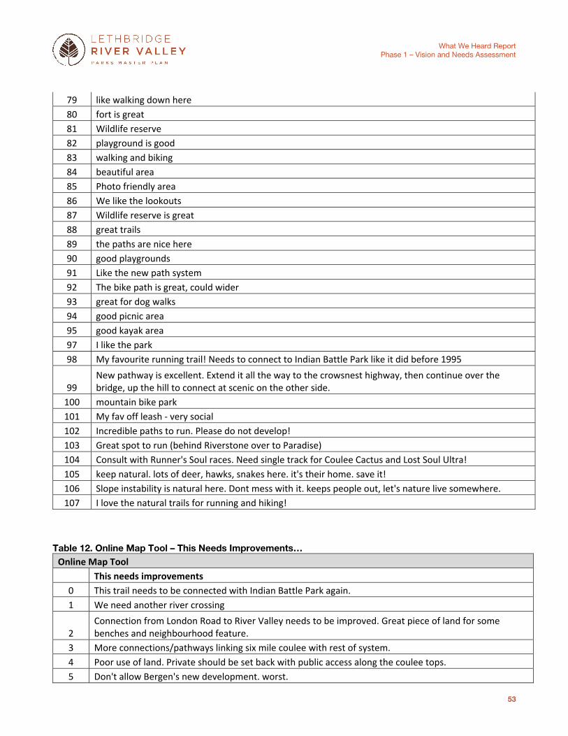
What We Heard Report
Phase 1 – Vision and Needs Assessment
53
79 like walking down here 80 fort is great 81 Wildlife reserve 82 playground is good 83 walking and biking 84 beautiful area 85 Photo friendly area 86 We like the lookouts 87 Wildlife reserve is great 88 great trails 89 the paths are nice here 90 good playgrounds 91 Like the new path system 92 The bike path is great, could wider 93 great for dog walks 94 good picnic area 95 good kayak area 97 I like the park 98 My favourite running trail! Needs to connect to Indian Battle Park like it did before 1995
99 New pathway is excellent. Extend it all the way to the crowsnest highway, then continue over the bridge, up the hill to connect at scenic on the other side.
100 mountain bike park 101 My fav off leash - very social 102 Incredible paths to run. Please do not develop! 103 Great spot to run (behind Riverstone over to Paradise) 104 Consult with Runner's Soul races. Need single track for Coulee Cactus and Lost Soul Ultra! 105 keep natural. lots of deer, hawks, snakes here. it's their home. save it! 106 Slope instability is natural here. Dont mess with it. keeps people out, let's nature live somewhere. 107 I love the natural trails for running and hiking!
Table 12. Online Map Tool – This Needs Improvements… Online Map Tool
This needs improvements 0 This trail needs to be connected with Indian Battle Park again. 1 We need another river crossing
2 Connection from London Road to River Valley needs to be improved. Great piece of land for some benches and neighbourhood feature.
3 More connections/pathways linking six mile coulee with rest of system. 4 Poor use of land. Private should be set back with public access along the coulee tops. 5 Don't allow Bergen's new development. worst.
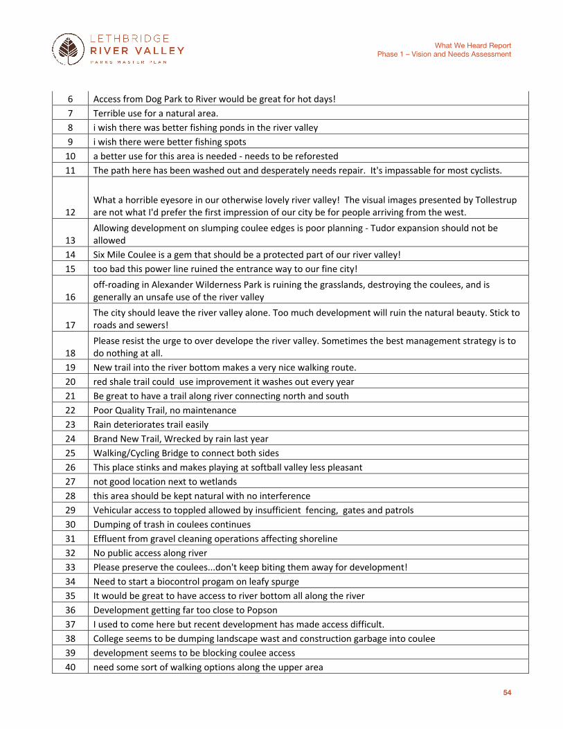
What We Heard Report
Phase 1 – Vision and Needs Assessment
54
6 Access from Dog Park to River would be great for hot days! 7 Terrible use for a natural area. 8 i wish there was better fishing ponds in the river valley 9 i wish there were better fishing spots
10 a better use for this area is needed - needs to be reforested 11 The path here has been washed out and desperately needs repair. It's impassable for most cyclists.
12 What a horrible eyesore in our otherwise lovely river valley! The visual images presented by Tollestrup are not what I'd prefer the first impression of our city be for people arriving from the west.
13 Allowing development on slumping coulee edges is poor planning - Tudor expansion should not be allowed
14 Six Mile Coulee is a gem that should be a protected part of our river valley! 15 too bad this power line ruined the entrance way to our fine city!
16 off-roading in Alexander Wilderness Park is ruining the grasslands, destroying the coulees, and is generally an unsafe use of the river valley
17 The city should leave the river valley alone. Too much development will ruin the natural beauty. Stick to roads and sewers!
18 Please resist the urge to over develope the river valley. Sometimes the best management strategy is to do nothing at all.
19 New trail into the river bottom makes a very nice walking route. 20 red shale trail could use improvement it washes out every year 21 Be great to have a trail along river connecting north and south 22 Poor Quality Trail, no maintenance 23 Rain deteriorates trail easily 24 Brand New Trail, Wrecked by rain last year 25 Walking/Cycling Bridge to connect both sides 26 This place stinks and makes playing at softball valley less pleasant 27 not good location next to wetlands 28 this area should be kept natural with no interference 29 Vehicular access to toppled allowed by insufficient fencing, gates and patrols 30 Dumping of trash in coulees continues 31 Effluent from gravel cleaning operations affecting shoreline 32 No public access along river 33 Please preserve the coulees...don't keep biting them away for development! 34 Need to start a biocontrol progam on leafy spurge 35 It would be great to have access to river bottom all along the river 36 Development getting far too close to Popson 37 I used to come here but recent development has made access difficult. 38 College seems to be dumping landscape wast and construction garbage into coulee 39 development seems to be blocking coulee access 40 need some sort of walking options along the upper area

What We Heard Report
Phase 1 – Vision and Needs Assessment
55
41 Walking access needed 42 development caused slumpage in this area 43 There is no coulee top access in this area 44 This needs a permanent fix. Each rainfall deteriorates it; dangerous! 45 This is very dangerous for pedestrians and cyclists. Desperately needs repair! 46 Coulee slumping due to residential over-watering! 47 What is the use of building new washrooms only to keep them locked up the whole year! 48 Should not be touched as there are Bald eagles nesting in the area.
49 Reduce or stop further development as it is beginning to have a negative impact on adjacent nature reserve
50 Needs major work 51 Path Needs fixing
52 The pathway should be repaired. Perhaps the edge of the golf course could be used like at Henderson.
53 The timeframe to repair this path is unacceptable. The path needs to be re-engineered to be more resilient and to stay out of the natural water course.
54 The road to Popson really should be paved. 55 The transition from the whoop-up drive cycle path to 6th Avenue is really not acceptable. 56 Functional access around Golf Course desperately needed - significantly reduces Park utility 57 Decent boat ramp (for tubes, etc) needed
58 egress from the river (for canoes, kayaks, tubes, ...) would be beneficial here - it is sketchy trying to exit the river at this point
59 Agree with better river access at these point
60 Tollestrup use to be sheltered from view, however it is gettting out of control, especially as the first thing you see entering the city
61 Build proper trails with good drainage or leave the natural trails only 62 Support for trail maintenance for runniing and riding 63 offlease dog areas in the river valley are wreaking the environment 64 Pathway improved
65 A crosswalk at the 11 Street intersection would allow safe access to this part of the walking/cycling trail. 66 Would like to see some minimal trails through coulees built
67 I agree with the comment about insufficient fencing and patrols to keep out illegal off road vehicular use of the coulees and top land.
68 I agree, please do not overdevelop the river valley and lessen its natural beauty and the wildlife habitat it provides.
69 preserve this area from development. It presently serves many walkers. 70 this slumping shows that housing development along the edge of coulee land is a poor decision.
71 All the silt from slumping and also storm water dumped into Six Mile Coulee Creek has damaged the water quality of the creek.
72 Pathway is in extreme disrepair and needs improvement

What We Heard Report
Phase 1 – Vision and Needs Assessment
56
73 Would love to see a proper exit for Stand Up Paddle Boards, canoes, tubes etc. Something safe for the user, but also to help alleviate the environmental damage being caused
74 would be nice if this trail was connected again to the other side 75 Echo the other statements: this trail is very popular but is often in disrepair from rain 76 Would like if this path could be connected to those that lead to Indian Battle Park 77 power lines are ugly at entrance to city 78 gun range is dangerous 79 Need a path to link Indian Battle Park to Peenaquim
80 Tubing will always be a thing here in Leth, and as per the ramp for tubing up by the weir, a good exit ramp and maybe some stairs up to that parking lot.
81 More Hideabag things on not just the main trails, lets keep options plentiful to keep litter down. 82 Paved Road to Popson! Or atleast more maintenance 83 reconnect the pathways here 84 Needs a bridge here
85 We need good bike access across this bridge and up along the road a far as scenic drive (where it can connect to a path that ends there)
86 Agree with all other commenters. This path needs to be connected to allow uninterrupted riding/running/walking along the river
87 Development should not occur here. 88 Development should not occur here, save for a future highlevel bridge. 89 Coal Banks Trail needs to be joined up 90 Damage from beaver is appalling
91
It does not seem to have the same protection as other Nature Reserves. You won't put up No Dogs by-law sign like you have at the Helen Schuler Nature Reserve. Quit bluffing and do something about dogs in the EHW.
92 Suggested improvements: Better trail design to enhance drainage, avoid erosion and multiple tracks.. More attention to control of non-native plants. Improve compliance with need to scoop up poop.
93 Lack of a path along the river valley bottom is a major gap in our community's system of pathways. Consider introducing winter use through the golf course.
94 Control of restricted noxious weeds (leafy spurge, knapweed, Russian olive) is needed.
95
It would be a wonderful and far-sighted decision if Pavan Park could be expanded northward to incorporate the well forested river valley lands currently under private ownership. I fear that the significant natural features will be destroyed and there wil
96 Over the last few decades I have witnessed major invasion by Absinthe Sage into grasslands. Aggressive control is needed.
97
This aggregate development is a major impediment to a linear trail system along our river valley? What plans are being made to phase it out and restore to a state that will allow use and enjoyment by all City residents.
98 Extensive erosion and garbage in the coulee here are an eyesore and reflect badly on our care for coulees.
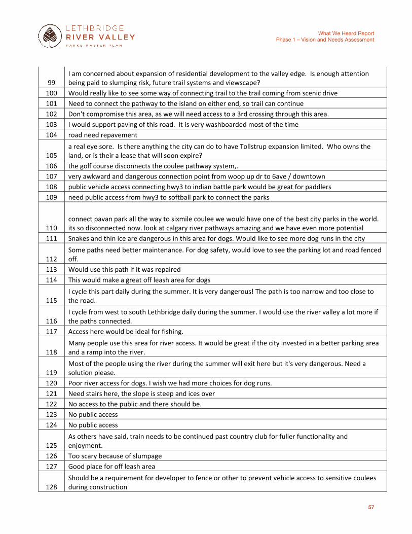
What We Heard Report
Phase 1 – Vision and Needs Assessment
57
99 I am concerned about expansion of residential development to the valley edge. Is enough attention being paid to slumping risk, future trail systems and viewscape?
100 Would really like to see some way of connecting trail to the trail coming from scenic drive 101 Need to connect the pathway to the island on either end, so trail can continue 102 Don't compromise this area, as we will need access to a 3rd crossing through this area. 103 I would support paving of this road. It is very washboarded most of the time 104 road need repavement
105 a real eye sore. Is there anything the city can do to have Tollstrup expansion limited. Who owns the land, or is their a lease that will soon expire?
106 the golf course disconnects the coulee pathway system,. 107 very awkward and dangerous connection point from woop up dr to 6ave / downtown 108 public vehicle access connecting hwy3 to indian battle park would be great for paddlers 109 need public access from hwy3 to softball park to connect the parks
110 connect pavan park all the way to sixmile coulee we would have one of the best city parks in the world. its so disconnected now. look at calgary river pathways amazing and we have even more potential
111 Snakes and thin ice are dangerous in this area for dogs. Would like to see more dog runs in the city
112 Some paths need better maintenance. For dog safety, would love to see the parking lot and road fenced off.
113 Would use this path if it was repaired 114 This would make a great off leash area for dogs
115 I cycle this part daily during the summer. It is very dangerous! The path is too narrow and too close to the road.
116 I cycle from west to south Lethbridge daily during the summer. I would use the river valley a lot more if the paths connected.
117 Access here would be ideal for fishing.
118 Many people use this area for river access. It would be great if the city invested in a better parking area and a ramp into the river.
119 Most of the people using the river during the summer will exit here but it's very dangerous. Need a solution please.
120 Poor river access for dogs. I wish we had more choices for dog runs. 121 Need stairs here, the slope is steep and ices over 122 No access to the public and there should be. 123 No public access 124 No public access
125 As others have said, train needs to be continued past country club for fuller functionality and enjoyment.
126 Too scary because of slumpage 127 Good place for off leash area
128 Should be a requirement for developer to fence or other to prevent vehicle access to sensitive coulees during construction

What We Heard Report
Phase 1 – Vision and Needs Assessment
58
129 Worst example of reclamation work ever! The new road disturbed a massive amount of the coulees around it and they are now covered with weeds
130 This coul├â┬⌠e ravine has been destroyed by mountain bikes. Proper mountain bike trails need to be mapped and developed to prevent erosion,trail braiding and washout
131 Better way finding needed. I have seen people in motorized wheelchairs using the roads because they don't know there is a trail or are not sure where it goes?
132 Access to this not well thought out. Has significantly increased bike trafic through coulees in nature reserve.
133 Bike /running trail access and connection into downtown was promised as part of scenic expansion 134 Awful reclamation when bike path was added...all invasives along the trail edge
135 This guy created his own rotational slump. Nice golf green. Too bad you were allowed to buy the view and change the geomorphology in your purchase
136 needs improvement to slope slippage 137 Needs improvement and the smell from the sewage is awful. 138 Would love to see this road go through to the Softball diamonds 139 This is always washed out. 140 So bad.
141 Really miss the Lethbridge Visitors Center. Would love to see some public restrooms available here. 142 Would love to see a walking path on this side of the road. 143 Rain always washes out or ruins this path.
144
This area is, and hopefully should remain, a beautiful scenic view that the city should value as such and keep this area as a nature reserve. What a legacy for the city to be prudent in retaining areas for the sake of the environment and not for $$ in so
145 why is this looking like a dump? 146 No further development should be allowed - the coulees are being ruined.
147
We continue to develop land too close to the coulees on both sides of the river valley. We need to re-evaluate how close we allow developement to the coulees. We are not learning from all the develope done already and the drastic damage it is doing to th
148 Fence needs to be improved - too many moter vehicles (trail bikes, 4x4s) get thorugh and tear up the landscape
149 ball diamonds too close to the water treatment plant 150 would like to use the coulee trails here 151 concern for wildlife in this area 152 it is ugly 153 Improve flood prevention 154 Maintain and improve the bike park 155 Bike Park is not pretty enough 156 more garbage and recycling bins 157 Paths are nice here 158 golf balls come at us

What We Heard Report
Phase 1 – Vision and Needs Assessment
59
159 poor drainage wrecks new trails 160 more doggie bag pick ups 161 more parking access 162 improve community access to river valley 163 Create a kayak play park here
164 Really need to hide this away. It takes away from the first impression people get when coming to Lethbridge and effectively ends the walk-ability of this side of the valley.
165 Challenging location for the gun range, particularly as public foot traffic continues to increase.
166 Would really like to see the pedestrian bridge that used to be in this general area put back in so that you can cross to both sides of the valley.
167
Stop allowing all the parking lots surface runoff to enter six mile coulee it is causing lateral sidecutting and ultimately slumping. Not that many years ago six mile coulee was just a trickle by summer time, now it runs full all the time.
168 agreed.. keep this area natural.. no development!!!
169 Runners who use this trail need a different access point. They run through the dog park and expect dogs to leave them alone... it is silly
170 Put up a history board near here, and a couple of picnic tables. It is very close to the site of Nick Sheran's original mine.
171 I agree with Terrell... tubing, rafting are great fun. Put in something inexpensive... nothing elaborate is needed. Make the ramp by the sewage treatment plant more accessable too... see note there.
172 I use the river valley for hiking, biking, bird watching, and general nature observation and enjoyment
173 Reclaim this land, restore it to a park, and create bike trails that connect all the way up north to Pavan and al l the way south past the golf course
174 These developments are ruining the coulee; Priveleged living for rich people at the expense of water table and natural habitat
175 Stop selling off excellent parkland to private interests. This area should be a park accessible to all residents, not some high stooop for rich people to build excessive houses that damage the coulee.
176 Agree with other commenter. This landscaping is an atrocity
177
Agree with other commenter. The path along whoo[p up need some re-landscaping to set it back from the roadway and widen it. Addition of a few inlets for benches/stops incl shade structures would be ideal.
178 A bylaw should be passed stating that any motorized vehicle found in this area will be confiscated and destroyed.
179 These kinds of developments need to stop. Development should not be allowed within 20m of coulee edge.
180 Gold course should be more naturalized. I am concerned about fertilizer impact on river.
181 This road should be paved, and a bike path should be added running parallel to the roadway. Extend said pathway north all the way to University drive path system.

What We Heard Report
Phase 1 – Vision and Needs Assessment
60
182 Hard to keep dogs away from the river in winter when dangerous ice levels threaten theirs and their owners safety
183 Needs fencing - drowning risk 184 Poor location for mulch - speeding 185 Am hoping fenced in is for smaller fragile dogs 186 Unsafe for dogs due to snakes 187 Only safe river access for kayak and canoe. Poor parking and knee deep mud 188 Would love shade and more seating 189 Low areas in parking lot cause pooling and drinking / run over haZard 190 Shade trees would be fabulous 191 More education to runners - who yell at dogs for running up to them 192 connection around golf course needed! 193 homeless camp here sometimes. 194 Need connection as many have stated!


![[Day 3] Agcommons: What We've Heard](https://img.pdfslide.net/doc/110x75/55507168b4c90524138b4c81/day-3-agcommons-what-weve-heard.jpg)