Embed Size (px)
Citation preview

1
What We Heard Report Phase 1: Foundations
—
O2 Planning + Design In collaboration with Anne Muecke, CBCL, and TransActive Solutions
—
October 2015
—
Prepared for Halifax Regional Municipality

2 Halifax Green Network
Prepared for
Halifax Regional Municipality
Prepared by
In collaboration with
Anne Muecke, CBCL, and TransActive Solutions

3
1 INTRODUCTION 9
1.1 Engagement Approach 10
1.2 Engagement Process 11
2 WHAT WE DID 13
2.1 Who We Engaged 14
2.2 What Activities We Did 15
2.3 How We Analyzed the Input 19
3 WHAT WE HEARD - OPEN SPACE ASSESSMENT 20
3.1 Ecosystems 21
3.2 Working Landscapes 29
3.3 Recreation and Trails 34
3.4 Communities 44
3.5 Cultural Landscapes 50
3.6 Others 63
4 WHAT WE HEARD - VISION COMPONENTS 64
5 HOW WE USED THE INPUT 66

4 Halifax Green Network
Executive Summary

5
The Halifax Regional Municipality (HRM) is developing the Halifax Green Network Plan (HGNP) – a Greenbelting and Public Open Space Priorities Plan for the Region. This project is part of the Regional Municipal Planning Strategy – a Regional Plan approved in October 2014 that provides a framework for how the HRM wants to grow and develop as a vibrant and sustainable Region and community. The HGNP will establish a planning and land management framework for open space to help advance the multiple environmental, social, cultural, and economic objectives of the HRM, as well as informing future development and growth patterns. Extensive public and stakeholder engagement is being conducted as part of the development of the HGNP. The objectives of the engagement process are to:• Broadly engage the community (regional centre, urban, and rural
communities) and stakeholder groups (provincial departments, NGOs, First Nations, ethnic groups, and other interests).
• Provide numerous opportunities for stakeholder groups with various interests to give input in order to balance economic, environmental, and socio-cultural interests.
• Provide opportunities for public involvement that are convenient and accessible.
• Build on past engagement successes (e.g. Regional Plan 2014) to provide continuity and acknowledge prior contributions.
The first round of engagement, Phase 1 – Foundations, took place from May to July 2015. During this time residents from the regional centre, urban and rural communities, as well as various stakeholder groups, had the opportunity to provide their thoughts and perspectives on the issues, opportunities, values, and vision that should inform the HGNP.
Engagement Approach Engagement and communication activities throughout the development of the HGNP are planned in accordance with the HRM Community Engagement Strategy (2008). Engagement activities and communication tactics correspond to the level for public impact along the continuum of community engagement, from ‘Information Sharing’ to ‘Active Participation’. This flexible approach to public participation allows for levels of engagement to vary through each project phase, and be tailored to different audiences. A decentralized approach to public and stakeholder engagement was used to provide multiple, convenient entry points into the conversation, and engage them where they are.

6 Halifax Green Network
Engagement Process
Public and Stakeholder engagement will be undertaken in three phases. Each engagement phase corresponds to key decision points in the process, as indicated below:
Five core open space themes were used to frame the discussion during Phase 1:
ECOSYSTEMS + BIODIVERSITY
CULTURAL LANDSCAPES
RECREATION + TRAILS
COMMUNITIES
WORKING LANDSCAPES
Natural systems that support plant and animal life.
value statement Diverse and healthy ecosystems provide a series of important ecosystem services and benefits, such as provisioning (water, food, and fiber), regulating (climate and water), and supporting natural and built environments (habitats, water quality).
Places that connect us to our history and define our regional identity.
value statement Cultural landscapes, including their historical context and land uses, are the foundations for the communities’ sense of place and identity.
Places that support economy activity.
value statement Working landscapes provide important economic development opportunities, while ensuring the viability of ecosystems in the long-term. The preservation of traditional land-uses, food security and the viability of rural communities all strongly depend on a thriving working landscape.
Places we go for fun and facilities we use to move around.
value statement Connected parks, wilderness areas, and trails provide a wide range of recreational and active transportation opportunities within reach of communities, which can help promote active lifestyles, contribute to quality of life, and stimulate economic investment.
Places we live and work, and play close to home.
value statement Parks and open spaces contribute to the unique sense of place, as well as help shape community identity and community form. Strategic open space protection helps to ensure that growth management objectives are achieved through sustainable development patterns. Accessible urban open spaces are connected by foot, bicycle, and transit, and promote an active lifestyle, as well as contribute to the overall quality of life.

7
WHAT WE DID WHO WE ENGAGEDThe engagement process sought feedback from the general public, HRM staff and committee, numerous governmental departments and stakeholders from a wide range of interests, such as environment, development, natural resources, recreation, economy, culture, social, health and well-being, transportation, energy, and education. WHAT ACTIVITIES WE DID:The following activities took place during the first phase of engagement: • An online mapping tool• Two (2) open houses• Ten (10) pop-up open houses • Two (2) stakeholder workshops focused on the cultural
landscape• Surveys: online and in-person• Three (3) stakeholder workshops• One (1) government workshop and two (2) meetings• Six (6) stakeholder meetings
HOW WE ANALYZED THE INPUT These engagement activities resulted in feedback by approximately 560 people from across the HRM which provided over 9,000 comments and/or ideas. Input was combined into a single database and, using a ‘tagging’ system, input was organized by themes (ecosystems, working landscapes, recreation and trails, communities, and cultural landscapes), sub-themes (36 distinct topics), and types of comments (issues, values, opportunities, or information). This categorization method was useful to organize the input, draw relationships between ideas, as well as to represent the proportion of comments related to each other.

8 Halifax Green Network
WHAT WE HEARD Input is presented in two distinct sections. The first section (Open Space Assessment) represents comments received on issues, opportunities, and values. The second section (Vision) reports on how the public and stakeholders imagine their preferred future open space network.
HOW WE USED THE INPUTInput gathered through the first phase of engagement informed the development of the State of the Landscape Report: Issues and Opportunities. This document provides a summary of the current state of the open space system and an overview of the key issues and opportunities that will influence the development of the HGNP.
Input informed the development of the report in the following ways:• Comments were referenced to determine issues, opportunities, and areas of
concern the project team researched and documented.• Comments were used to draft high level value statements for each of the five
core themes.
Input will also influence Phase 2 – Planning Framework, including:• The development of the Plan’s vision, principles, and objectives.• The selection of performance indicators to be utilized during scenario
modelling.

9
Introduction
1

10 Halifax Green Network
The Halifax Regional Municipality (HRM) is developing the Halifax Green Network Plan (HGNP) as recommended in the Regional Plan, approved in October 2014, which calls for a Greenbelting and Public Open Space Priorities Plan for the Region. The Regional Plan provides a framework for how the HRM wants to grow and develop as a vibrant and sustainable Region and community. The HGNP will establish a planning and land management framework for open space to help advance the multiple environmental, social, cultural, and economic objectives of the HRM, as well as a means to inform future development and growth patterns. Extensive public and stakeholder engagement is being conducted as part of the development of the HGNP. The objectives of the engagement process are to:
• Broadly engage the community (regional centre, urban, and rural communities) and stakeholder groups (provincial departments, NGOs, First Nations, ethnic groups, and other interests).
• Provide numerous opportunities for stakeholder groups with various interests to give input in order to balance economic, environmental, and socio-cultural interests.
• Provide opportunities for public involvement that are convenient and accessible.
• Build on past engagement successes (e.g. Regional Plan 2014) to provide continuity and acknowledge prior contributions.
1.1 ENGAGEMENT APPROACH
Engagement and communication activities are undertaken in accordance with the HRM Community Engagement Strategy (2008). Engagement activities and communication tactics correspond to the level of public impact along the continuum of community engagement. This flexible approach to public participation allows for levels of engagement to vary through each project phase, and be tailored to different stakeholder audiences. The HRM’s continuum of community engagement is illustrated in Figure 1.
Figure 1. Continuum of Community Engagement
11
The Phase 1 consultation process included a number of communications and engagement activities designed to share and seek feedback. To ensure the highest levels of engagement, a decentralized approach to consultation was deployed. A decentralized engagement approach is a highly effective, non-traditional approach, where the project team seeks out community events to engage residents where they are, rather than requiring them to attend an open house or formal project event. A decentralized approach, when coupled with traditional open houses and online engagement tools, provides multiple entry points into the conversation and the ability to reach people in the manner that best suits their needs. This approach worked well for Phase I and will be considered for Phase II engagement.
1.2 ENGAGEMENT PROCESS
Public engagement is critical to the success of the HGNP and HRM is committed to engage the public and stakeholders throughout the planning process. Engagement will be undertaken throughout the development of the HGNP at strategic points in each of the three phases, as indicated below:
Phase 1: Foundations May-July 2015
Phase 2: Planning Direction August-February 2016 Phase 3: Draft and Final Plan April-June 2016
Understanding what we have, what we value, and where we want to go Output: State of the Landscape Report and community values, issues, and goals
Evaluating and refining open spaces scenarios and options, and developing planning, and implementing directions Output: Policy objectives and ecological and planning assessment
Finalizing preferred scenarios and solutions – finalizing the Plan Output: Comprehensive planning and implementation framework
12 Halifax Green Network
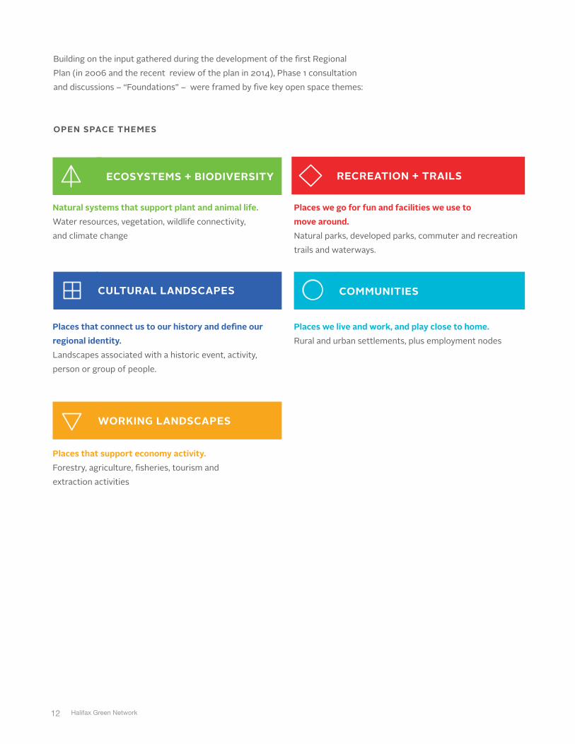
Building on the input gathered during the development of the first Regional Plan (in 2006 and the recent review of the plan in 2014), Phase 1 consultation and discussions – “Foundations” – were framed by five key open space themes:
OPEN SPACE THEMES
ECOSYSTEMS + BIODIVERSITY
CULTURAL LANDSCAPES
RECREATION + TRAILS
COMMUNITIES
WORKING LANDSCAPES
Natural systems that support plant and animal life. Water resources, vegetation, wildlife connectivity, and climate change
Places that connect us to our history and define our regional identity. Landscapes associated with a historic event, activity, person or group of people.
Places that support economy activity. Forestry, agriculture, fisheries, tourism and extraction activities
Places we go for fun and facilities we use to move around. Natural parks, developed parks, commuter and recreation trails and waterways.
Places we live and work, and play close to home. Rural and urban settlements, plus employment nodes

13
What We Did
2

14 Halifax Green Network
From May to July 2015, the first engagement phase sought input from stakeholders and the public on open space values, issues, opportunities, and vision for an open space network. Key stakeholder interviews were also conducted and a combination of online tools and in-person events generated input to inform the development of the State of the Landscape Report: Issues and Opportunities. The following sections present details on who we engaged, what activities we did, and how we analyzed the input gathered.
2.1 WHO WE ENGAGED
In addition to the general public and an internal HRM working committee, the engagement process sought feedback from a large and diverse range of stakeholder groups and numerous governmental departments, such as :
NON-GOVERNMENTAL ORGANIZATIONS AND INTEREST GROUPS:• Environment and Community (e.g. Our HRM Alliance)• Development (e.g. Urban Development Institute of Nova Scotia)• Natural Resources (e.g., Mining Association of Nova Scotia, Nova Scotia
Woodlot Owners, Operators and Association)• Recreation and Trails (e.g., Nova Scotia Trails, Halifax Regional Trails
Association, Sport Nova Scotia, Recreation NS, various outdoor recreation user groups)
• Economy (e.g., Chambers of Commerce, Destination Halifax)• Culture (e.g., First Nations, African Nova Scotian communities, Shubenacadie
Canal Commission, Black Cultural Centre, Acadian communities)• Social and Health + Wellbeing• Transportation/Energy Infrastructure• Resident/Community Associations• Post-secondary institutions (e.g., Dalhousie School of Resource and
Environmental Studies, Dalhousie School of Planning)
PROVINCIAL GOVERNMENT STAKEHOLDERS:• Department of Communities Culture & Heritage• Department of Environment
• Protected Areas and Wetland Branch
• Parks and Recreation Division
• Department of Economic and Rural Development and Tourism• Department of Natural Resources
• Nova Scotia Provincial Parks
• Department of Health & Wellness• Department of Municipal Affairs• Department of Energy• Department of Agriculture• Transportation and Infrastructure Renewal• Department of Fisheries & Aquaculture• Office of Aboriginal Affairs

15
2.2 WHAT ACTIVITIES WE DID
The engagement process included a number of different communications and outreach activities to share information and to seek input into a future vision for a regional open space network – its current issues, opportunities, and values that should inform its development. These activities resulted in feedback by approximately 560 people from across the HRM. Phase 1 included the following tools and inputs:
• An interactive map where citizens use “push pins” to provide input (http://engage.o2design.com/halifax/engage_map/). The tool included key background information about the project and consultation process, as well as an interactive online map that was linked to GIS information. The online map received a total of 1,184 “push pins” during July 2015.
• Two (2) open houses• Ten (10) pop-up open houses • Two (2) stakeholder workshops focused on the cultural landscape• One (1) survey (online and in-person)• Three (3) stakeholder workshops• One (1) government workshop and two (2) meetings• Six (6) stakeholder meetings
During the engagement, 9,496 ideas were shared with the project team, as follows:• Recreation: 5,257 ideas (55%)• Ecosystems: 2,021 ideas (21%) • Cultural Landscapes: 1,105 ideas (12%)• Communities: 748 ideas (8%)• Working Landscapes: 365 ideas (4%)
PHASE ONE ENGAGEMENT BY THE NUMBERS
Total Participants
Online Map Tool Pins Ecosystem Working Landscapes Communities Recreation + Trails Cultural Landscapes
Online Surveys
Paper Surveys
Total Website Visits
560 1,184 230 18 44 750 142
46
11
687

16 Halifax Green Network
ECOSYSTEMS
CULTURAL LANDSCAPES
RECREATION + TRAILS
COMMUNITIES
WORKING LANDSCAPES
COMMENTS/IDEAS ORGANIZED PER THEME
21%
55%
4%8%
12%

17
ONLINE WEB PORTAL AND LOCATION-BASED SURVEY TOOL

18 Halifax Green Network
IN-PERSON ENGAGEMENT EVENTS
SOCIAL ENGAGEMENT

19
FEEDBACK SUNBURST
2.3 HOW WE ANALYZED THE INPUTInput from the online map tool, engagement events, and questionnaires was gathered into a single database. Individual comments and ideas were categorized by the five themes (ecosystems, working landscapes, recreation and trails, communities, and cultural landscapes). A total of 36 distinct topics (or sub-themes) emerged from the gathered input. Using a ‘tagging’ system, comments were categorized by sub-themes, and then attributed a ‘type of comment’ identifier (i.e., issues, values, opportunities, or information). This categorization method was useful to organize the input and draw relationships between ideas, as well as visually represent the proportion of comments related to each theme and sub-theme.
Comments were summarized through this organization of (1) themes, (2) sub-themes, and (3) types of comments, with details regarding the types of issues, values, or
opportunities (e.g., connectivity, access, maintenance, amenities, etc.) highlighted. When available, information on location was carried over. Additional information provided by submissions (letters and emails) and interviews is also included in the summary. A summary of the input is provided in section three. Public and stakeholder input is summarized below by open space themes. For each the theme, an image of the online map tool is provided which highlights areas that have been publicly identified as important, valued, or at risk. A high density of comments in certain areas is representative of public values, but also reflects ongoing public advocacy. Areas that received a high level of comments include the Blue Mountain Birch Cove Lakes (BMBCL), Purcell’s Cove Backlands, and the asphalt plant project in St. Margaret’s Bay.

20 Halifax Green Network
What We Heard
Open Space Assessment
3
Public and stakeholder input is summarized below by open space themes. For each the theme, an image of the online map tool is provided which highlights areas that have been publicly identified as important, valued, or at risk. A high density of comments in certain areas is representative of public values, but also reflects ongoing public advocacy. Areas that received a high level of comments include the Blue Mountain Birch Cove Lakes (BMBCL), Purcell’s Cove Backlands, and the asphalt plant project in St. Margaret’s Bay.

21
3.1 ECOSYSTEMS
3.1.1 GEOLOGY, LANDFORM, AND SOILS
VALUES• Areas with special geological features and landforms (e.g. whaleback granite
outcrops).• Coastal landscape elements (viewscapes) of coves and inlets, headlands,
beaches, and off shore islands.• Musquodoboit valley farm landscape.
ISSUES• Development on granite bedrock is economically challenging. Extensive
blasting is also required, which can impact integrity of ecosystems. • Development pressure on the remaining small pockets of prime agricultural
soils in and around the Regional Centre.
OPPORTUNITIES• Protection of prime agricultural land (e.g., zoning, food security policy).
ONLINE MAP TOOL ECOSYSTEMS

22 Halifax Green Network
3.1.2 BIODIVERSITY
VALUES• Benefits of ecosystems (e.g., waste water rehabilitation, provision of potable
water, filtration, clean air).• Rich diversity of ecosystems (e.g., barrens, old-growth forest, mature forest).• Mosaic landscape of barrens, forest, and wetlands.• Patch of wilderness along coastline.• Viable living natural landscape at the doorstep of communities.• Fire susceptible and fire dependent ecosystems.• Urban forests as ecosystems (e.g., habitats for local bird population, migratory
species).• Existing conservation efforts to preserve sensitive coastal areas (e.g. Troop
Islands, Micou Islands, 100 Islands).
Place Specific (alphabetical order):• Abraham Lake Nature Reserve:
• Dense woodland stand with resident breeding birds found in few places on
mainland NS
• Pristine fir and hemlocks
• Blue Mountain Birch Cove Lakes (BMBCL):• Headwater of watershed
• Rare barrens vegetation, granite outcrops
• Rare white pine forest
• Old growth forest
• Marshes and wetlands
• Mainland moose habitat
• Eastern Shore Islands / Bay of Islands:• Eastern Shore Islands Wildlife Management Area
• 50 vegetated islands and 15 rock ledges have been protected
• Nesting habitat of many seabirds, of which several are endangered
• Hartlen Point: • Yearly stopover for very rare bird species
• Excellent breeding and staging for birds
• Cobble stone and outerbeach with large salt marsh
• Piping Plovers have been observed. Chances that they will breed there in the
future as the sandy beach continues to grow.
• Martinique Beach / Bayers Islands Archipelago: • Dunes, estuary, and Bayer’s Islands provide very important habitat for both
breeding native species
• Best remaining stopover sites for migratory birds
• Best site in the province for breeding Blackpool Warblers accessible without
a boat

23
• Powder Mill Lake and surrounding area:• One of the few areas in metro where there is a large variety of breeding
woodland warblers and many neotropical birds
• Purcell’s Cove Backlands:• Extensive untouched wilderness area at the doorstep of the city with
spectacular vistas
• Rare ecological features are diverse, interesting, and some are globally rare
• Unique geology
• Lakes, ponds, streams, and wetlands
• Trees are fairly old and tall, and have not been burned for a long time
(protected by wet ground)
• Pockets of lady slippers in late spring
• Important presence of wildlife (e.g., loons, beavers, nighthawks, snapping
turtle nest, rabbit, beaver, muskrat, mink, coyote, fox, and deer)
• Sandy Cove and Chebucto Head Duncan’s Cove:• One of the best birding areas in HRM especially in Spring/Fall
• Substantial concentration of birds
• Often cited as a must go place for birding
• Coniferous and coastal barrens
• Sandy Lake area (St. Margaret’s Bay): • Ecologically sensitive area
• Geese and other waterfowl migrate in this area
• Eels migrate and spawn in this area
• Shubenacadie Canal area: • Migratory route for birds
• Very large lake, remnant of glacial lake Shubenacadie (extensive, minimally
disturbed forest along its shores, water quality, many fish species)
• Urban areas:• Russel Lake Park
• Prentice Lane
• Bissett Trail (nesting area for turtles and birds)
ISSUES• Fragmentation of habitats (e.g., infrastructure, development)• Development pressure on ecosystems• Shallow soils • Encroachment of residential development on natural habitats• Protection of barrens in urban areas.• Loss of old growth forest, which is invaluable to endangered species. Seems
that only the economically valuable species are protected. • Overuse and misuses of natural areas (e.g., high level of visitation, littering)

24 Halifax Green Network
Place Specific: • BMBCL:
• Vulnerable to more intense surrounding development
• Development is encroaching
• Potential highway extension through the area could result in forest clear-
cutting
• Eastern Shore Islands (ES)/ Bay of Islands:• The 100 Islands (Nova Scotia Nature Trust) Legacy and Eastern Shore
Islands Wildlife Management Area (WMA) have stopped short. Many islands
in this area of the shore have been missed by both protection designations.
• Martinique Beach / Bayer’s Islands Archipelago: • Not protected enough (most of Piping Plover have deserted the site)
• Too much traffic
• Uncontrolled off-leash dogs
• Too much clam digging
• Purcell’s Cove Backlands:• Vulnerable to development pressure and excessive recreational use
• Existing development encroachment
• Large proportion of private lands zoned as ‘urban reserve.’ This offers
temporary protection only.
• Misuses (e.g., illegal campfires, littering, ATVs, fireworks, snow and garbage
dumping)
• Fire barrens at Backlands – ecosystem based on fire for regeneration, need
to recognize this and cease to build houses in the barrens.
• Sandy Lake area (St. Margaret’s Bay):• Clear cutting
• Quarry and asphalt plant project
• Silver Sands:• Risk around ATVs use and off-road disturbances
OPPORTUNITIES• Apply principles of landscape ecology and conservation biology to guide the
development of the HGNP. • Contain development through densification and clustering, and retain as much
natural topography and vegetation as possible in urban development. • Consider areas extending beyond the HRM boundary in analysis and
recommendations (e.g. watershed boundaries need to extend beyond the HRM).
• Natural areas should be connected for biodiversity and people.• Core protected areas should be connected by natural corridors, with attention
to water-course buffers and connections across major barriers (highways) to ensure habitats are not fragmented.
• Designate areas where there have been fires as park sites and conservation areas.
• Improve connectivity between blocks of crown lands (e.g. between Five Bridges Lakes WA and the west side of Highway 333).

25
Governance + Monitoring:• Establish a tiered approach to land use planning for conservation with
categories, such as core conservation, biodiversity management areas, connectivity land, working landscape, and coastal areas.
• Monitor ecosystem health (e.g., annual report card on state of the green network, species at risk or endangered species)
• Continue to manage invasive species, preserve and promote ecological integrity, while also ensuring appropriate public access.
Place Specific:• BMBCL:
• Connect two wilderness areas - BMBCL and Five Bridges Lake (FBL).
• Create a regional park, as proposed for many years (acquire more lands).
• Eastern Shore Islands / Bay of Islands:• Ensure due diligence in terms of protection.
• Five Bridges Lake WA:• Need wildlife corridor between Five Bridges Lakes WA and Terence Bay WA,
and BMBCL to FBL.
• Purcell’s Cove Backlands:• Protect the rich sensitive ecosystem from inappropriate development.
• Preserve wildlife connectivity to Long Lake Provincial Park and
interconnected green areas, including the Terrance Bay Wilderness Area and
across the Chebucto Peninsula (as part of an urban greenbelt).
3.1.3 WATER
VALUES• Clean and healthy water to drink and swim in • Lakes and wetlands feed the local wells• Wetlands are large ecosystems that house a multitude of wildlife that do not
exist in other habitats• Important/sensitive watersheds:
• Chebucto Peninsula:
• Purcell’s Cove Backlands watersheds
• McIntosh Run is one of the most significant urban watershed that still
exists in a relatively undisturbed state especially in its lower reaches
• Long Lake
• Spryfield
• Dollar Lake
• Jack Pine
• Sandy Lake (Bedford Area; important for the Sackville River)

26 Halifax Green Network
• Important/sensitive rivers and water bodies:• Feely Lake
• Headwater to Little Sackville River
• Little lake
• Lower West Jeddore
• Historic coastal marshland at the head of Chezzetcook Harbour
• Musquodoboit Harbour
• Roach’s Pond (one of the most ecologically diverse places in Spryfield and in
Metro and an important stopover for migratory birds). There should be no
development within 50m of this pond.
• Salmon spawning habitat (Sandy Lake – Bedford area)
• Sackville River (rare fish habitat)
ISSUES • Flooding of Shubenacadie canal (regular now)• Impacts of ATVs on streams• Water table shared with industrial land-use represents a risk for pollution• Worried that development is affecting water quality of Sandy Lake (Bedford
area)• Concerns around impact of asphalt plant on water quality of St. Margaret’s
Bay• Ground water issues in Fall River (would like water servicing)
Riparian Areas: • Development of water edge and around lakes compromise natural systems• Some developments do not leave enough buffers along watercourses and
water bodies which leads to sedimentation • Riparian buffers are often inadequate• Langbrae Drive and Parkland Drive in Clayton Park (Halifax West) –
stormwater issues, compromise recreational trail• Agricultural runoff in Musquodoboit River• Sackville River – headwaters need protection• Ross Road recycling facility may be poisoning Salmon river watershed • Scraggy Lake near Moose River is polluted by adjacent tailing ponds / gold
mines• Bacteria in Lake Fletcher (human DNA)• Impact of development on water quality nearby – especially shallow lakes • Fresh water lakes are often used for dumping • Concerns about potential threat to water quality:
• Touquoy mining project (Ship Harbour Long lake Wilderness Area)
• Asphalt plant project in St. Margaret’s Bay
• Development around Colpitt Lake (Peninsula South) could affect water
quality in Williams Lake (Williams Lake is dependent on water supply from
Colpitt Lake and is part of the same watershed)

27
Stormwater Management:• Development runoff into watershed • Road salt • Runoff and sedimentation from nearby cutting areas and major infrastructure
(e.g. Ingramport Highway interchange)• Current stormwater system is too small to absorb urban growth • Storm drains are carrying pollutants into water bodies and streams• Permanent wetlands used as storm pond (e.g. Belchers Marsh Park)• Macintosh stormwater sewer outflows into river• Runoff of waste site at Otter Lake in many lakes • Nine Mile River – heavy rainfalls, hotspot for pollution
Wastewater Management:• Some homes and businesses still have sewage and greywater flowing by pipe
directly into the cove, which impacts water quality and recreational uses (e.g. Hubbards).
Education/Stewardship:• Lack of education and incentives for water conservation.
OPPORTUNITIES• Ban fertilizer on lands near lakes and waterways (e.g., Hemlock Ravine,
BMBCL, and places near Clayton Park).• Inventory and map all wetlands to ensure their protection (e.g. not filled by
development).• Reinstate/incorporate monitoring of aquatic habitat and water quality (e.g.
Governor’s Lake).• River headwaters and floodplains should be highlighted. Watershed Management: • Greater protection through watershed management planning• In sensitive watersheds, development applications should be required to
demonstrate that proposed development will not increase pollution beyond an established limit / carrying capacity.
Riparian Areas: • Maintain vegetated buffers around lakes, streams, and wetlands, as well as
harbours (wildlife corridors and stormwater runoff mitigation).• In secondary plans, riparian buffer requirements should be increased to a
minimum of 30m, and to at least 150m where they function as natural corridors.

28 Halifax Green Network
Stormwater Management + Low Impact Development (LID) Practices:• Establish on-site stormwater management policy. Stormwater runoff to be
‘dealt with’ within housing development lands (no further runoff after development than pre-development).
• New developments should include permeable surfaces, stormwater management infrastructure, and green roofs.
• Stringent regulations for clean stormwater/wastewater discharge.• Use storm pond to collect and/or slow down runoff. • Design stormwater management to make maximum use of natural flow. Open
streams and ponds rather than pipes.• Daylight streams in Halifax peninsula (e.g., Sawmill Creek, Kempt-Young
Street) so that they can accommodate more water runoff (flood control).• Restore and retrofit existing development using LID best practices as
opportunities arise (e.g., daylight streams, vegetated swales, impervious pavement, native species, indigenous tree species in the urban forest).
• Encourage LID practices (e.g., permeable pavement, greywater recycling), as well as the use of native plants.
Wastewater Management:• Implement wastewater management strategies to respond to septic system
failures (e.g., by-law enforcement, wastewater management districts).
Education/Stewardship:• Educate landowners on property stewardship – riparian areas.
3.1.4 CLIMATE CHANGE
ISSUES • Impact of climate change on ecosystems and biodiversity.
OPPORTUNITIES• Climate change modelling (School of Planning).• Encourage local actions to preserve ecosystems (e.g. encourage use of native
plants).

29
3.2 WORKING LANDSCAPES
3.2.1 GENERAL
ISSUES • Communities east of Musquodoboit Harbour want to diversify their economic
development as many industries have been lost over the years. A very small part of the regional economy is dependent on the extraction of land based resources.
• There is little interest in industrial park-type development in small communities (e.g. St. Margaret’s Bay). Communities prefer to support small businesses and local enterprises. Retail sector serves the community needs and are relatively independent of the regional centre.
OPPORTUNITIES• Wind farms could provide energy.• District energy utilizing the wastewater effl uent as a heating source; space or
domestic hot water depending upon the seasonal demand.
ONLINE MAP TOOL WORKING LANDSCAPES

30 Halifax Green Network
3.2.2 MINING/AGGREGATES
VALUES• Economic contribution of extraction activities.• Aggregates are important close to where they are required. There is no
development without aggregates.
ISSUES Mining:
• Proposed Touquoy gold mine: concerns about pollution by effluent (only
200m north of lake; Ship Harbour Long lake Wilderness Area).
• Mining can be in conflict with tourism and conservation objectives.
• Pollution of water by tailing ponds from old gold mines.
• Open mineral claim prevents some areas from being protected.
Aggregates:• Extraction activities are not compatible with recreation and residential
activities (e.g., excessive noise, traffic, pollution).
• Quarry activities lead to increased truck traffic.
• Asphalt plant project in Upper Tantallon raises concerns about pollution,
noise, traffic, visual impacts, etc. (temporary permission by DNR to use
Quarry Road).
• The development of a quarry near Miller Lake has raised concerns in the
community.
• Stephen’s quarry is not compatible with the proposed residential
development (Sister’s of Charity).
• Concern about the development of a subdivision when extraction activities
are completed (quarry in Powder Mill Lake area and mining near airport).
• Concerns about expansion of current quarry’s activities (Powder Mill Lake
area).
OPPORTUNITIES• For the industry: land swap when mineral potential is found. Other• Prohibit resource extraction in core natural areas.
3.2.3 AGRICULTURE
VALUES• Food security system: critical to enhance individual and community health.• Musquodoboit valley farming.• Small cattle farms on Eastern Shore.• Spryfield farming (last working farm in Spryfield) offers educational
opportunities.

31
• Cole Harbour farming.• Cole Harbour Heritage Farm (traditional working farm that educates and
entertains).• The Prestons – small agriculture, pig farm, etc. • Farmer’s Markets across the HRM.
ISSUES • Big farms are gone (Middle Musquodoboit), children are not farming the
family farms.• Fertilizer should be banned on lands near lakes and waterways (e.g., places
near Clayton Park, Hemlock Ravine, BMBCL).
OPPORTUNITIES• Implement a strong local food system in the HRM. This requires a healthy
environment and a holistic approach to social, environmental, and economic policy (e.g., land and resource preservation, community gathering places, infrastructure).
• Agriculture in the Musquodoboit Valley should be a priority (only remaining large-scale, lands within the HRM).
• Need to support more small-scale agriculture close to urban markets.• Support small scale farming and urban agricultural trends.• Implement agricultural conservation practices (e.g., retain wider riparian
buffers, leave larger wildlife habitat patches, leave more connected habitat).• Enhance urban food production through urban farms and community gardens.
3.2.4 FORESTRY
VALUES• Economic activity for forestry companies, land managers, small and large
private woodlot owners.• Otter Ponds demonstration forest.• Woodlands areas, where smart harvesting occurs are important to the
regional economy and provide an incentive for workers to live in the HRM. ISSUES • Competing use:
• forestry roads used by ATVs create safety concerns
• forests used for gathering
• forest used for recreational purposes (e.g. conflict with recreational trail users
and large lumber trucks)
• Clear cutting represents a significant concern for ecosystems (marine life,

32 Halifax Green Network
wildlife) and landscapes (e.g., Bowater lands, Ingramport).• Clear cutting in urban areas: illogical harvesting schemes to allow for urban
sprawl (e.g., Bayers Lake, Clayton Park, Kearney Lake, Bedford West, Dunbrack, Larry Utek).
• Forestry is not practiced sustainably in the vast majority of Nova Scotia and is putting ecosystems at risk.
• Post-cutting erosion is leading to siltation in water bodies and bay.• A local proposal for a Community Forest in the former Bowater lands was
rejected before the licenses were awarded. • Concerns that crown forestry plots are feeding biomass in Port Hawkesbury
(i.e. between Black Point and Boutiliers Point).
OPPORTUNITIES• Community forest project that would allow for recreation and industrial
benefits.• Crown Lands: opportunities for community-based management.• Implement forestry conservation practices (e.g., wider riparian buffers, smaller
clear cuts, larger wildlife habitat patches, and more connected habitats).
3.2.5 HUNTING AND GATHERING
VALUES• Hunting as ecotourism and recreational activities, as well as part of a food
security system.• Hunting and gathering are traditional activities and part of informal food
economy. ISSUES • Hunting and gathering are impacted by logging activities. OPPORTUNITIES• Protect wild harvesting areas.
3.2.6 FISHERIES/AQUACULTURE
VALUES• Some residents depend on fishing for an income (e.g. Musquodoboit Harbour)
or oyster harvesting (e.g. Mushaboom Harbour).• Active fishery areas:
• Herring Cove to Petpeswick
• Prospect
• Sambro
33
ISSUES • Concerns about fish processing plant projects: impact on ecosystem and
public access to shoreline.• Excessive clam digging is compromising important stopover migratory
shorebird habitats (e.g. Martinique Beach / Bayers Islands Archipelago).
3.2.7 TOURISM
VALUES• Parks and open spaces are key travel destinations.• Nice urban parks attract tourists and contribute to the image of the city (e.g.
Point Pleasant).• Rail to Trails is appealing to tourists.• All landscapes are important for tourism.• Scenic views and views for historic buildings and sites.• All opportunities for paddling. ISSUES • Economic value of ecotourism is often not represented or underestimated.• Mining industry affects landscapes and therefore tourism. • Route to Peggy’s Cove is important for the touristic experience, therefore
industrial development and other inappropriate uses should be restricted. • Small fishing villages attract tourists, but road expansion may be required to
absorb traffic, which will deter from the experience.
OPPORTUNITIES• Tourism is a growing sector of the regional and provincial economy.• Sheet Harbour: tourism is critical and the local industry and Chamber of
Commerce is interested in developing further (STEP: Strategic Tourism Expansion Program). Eastern Shore is partnering with 1000 Islands to develop recreation and tourism infrastructure. Bay of Islands has the potential to develop pride within the community.
• Nature-based tourism and ecotourism has the potential to help the economy, while ensuring the viability of ecosystems.
• Increase cycling opportunities (e.g. Blue Route). • More recreational trail opportunities (e.g. hiking). • Water routes have a lot of potential.• Increase recreation infrastructure (e.g., campgrounds, trails) for the benefit of
the community as well as for visitors.• There is a focus on colonial history. There are opportunities to also interpret
First Nations history.• Fisherman’s Wharf (Eastern Passage) could be better supported by local and
touristic promotions.

34 Halifax Green Network
3.3 RECREATION AND TRAILS
3.3.1 RECREATIONAL TRAILS + ACTIVE TRANSPORTATION
VALUESActive Transportation:• Active Transportation (AT) has many personal and community benefi ts, such
as active lifestyle and the potential to decrease automobile congestion and pollution.
• Rail to Trail and the Musquodoboit Trailway are great active transportation networks.
• AT trails are used to commute to downtown.• Waterfront parks provide opportunities for water commuting, which is very
rare for a city.• Penhorn is the hub for connecting the Cole Harbour, Russell Lake trail system
to the rest of Dartmouth – Shubie, Banook, and downtown Dartmouth.
Connectivity and Access:• Trails that connect communities to recreational destinations and other daily
needs destinations, as well as downtown.• Trails provide recreational opportunities in nature at the doorstep which
promotes active lifestyle. • Proximity of recreation trails in nature to the city centre.• Trails that provide access to waterfront, watercourses, and water bodies.
ONLINE MAP TOOL RECREATION & TRAILS

35
• Trails that are accessible by public transit.• Trails that provides scenic views and experience of being in nature.• Destinations along the trails.• Rail and trail that connects to cycle route.
Trail Types:• Diversity of trails and difficulties (i.e. paved to unpaved and easy to difficult).• Multi-use, all year-round trails. • Mountain bike (MTB) trails of variety of difficulties (preference for single trail).• Loop trails (e.g. Bluff Trails).• Water routes.
ATVs:• In rural areas, the use of ATVs for transportation on trails is generally
accepted. • There are few conflicts in the St. Margaret’s Bay area where, for the most
part, people have learned to accommodate each other.• People use ATVs for transportation on trails around St. Margaret’s Bay. This is
accepted in this rural area and not generally opposed by local people. There are few conflicts and for the most part users are courteous. HRM should recognize this reality and not require ATVs to stay off trails, where appropriate.
• Trails are shared because of implementation costs. ATVs registration fees are used to build trails.
Others:• Many of the recreational trails were used by the Mi’kmaq people (e.g. Purcell’s
Cove Backlands).
ISSUES Connectivity and Access:• Discontinuity of trails.• Loss of key links by development.• Incomplete trail connecting to the two ferry terminals.• Higways are barriers to connectivity. Overpasses not well linked.• Need to develop urban cycling infrastructure.• Too few long distance routes.• Lack of sidewalks in some communities (e.g. Penhorn Lake).• Access to Rails to Trails is limited.• Connections of Rails to Trails needs to be completed. • Connect Rails to Trails to adjacent parks or parks in the vicinity. • Trail access in winter is challenging (snow pushed into trailheads).
Water Routes:• Access to water routes is limited.

36 Halifax Green Network
Safety:• Emergency access: how to get emergency attention when in need, while
outdoors?
Trail Types:• There is currently a focus on long distance trails. Trail loops are required.• MTB trails in HRM are becoming rare as they have been excluded from
BMBCL and lands around Bayers Lake Business Park have been lost.
ATVs:• Some misuses of ATVs destroy the ecosystem (e.g. crown land by Cole
Harbour Provincial Park).• Impacts on wildlife.
Maintenance:• Winter maintenance could be improved (no snow pushed into trailheads).• Maintenance due to flooding and stormwater overruns.• Some trails are overused (e.g. tree roots are exposed).• Salt Marsh Trail still requires storm surge protection to be completed,
including living shores.• Maintenance depends on local volunteers. There are no trail standards,
therefore conditions are very variable.
Amenities:• Signage and wayfinding is lacking • Need for amenities along trails (e.g., washrooms, garbage bins, shelters, first
aid kit stations)
Safety:• Cycle infrastructure along high traffic roads or to cross busy roads.• Bottleneck.
User Conflicts:• On the Rails to Trails in urban areas, there are conflicts between ATV users,
horseback riders, and other users.• Off-leash dogs on trails.• Competing uses: forestry roads are used by ATVs, which create safety issues.• Clear cutting and forestry ruins the users experience of being immersed in
nature.
Governance:• Lack of support/respect for trail volunteers/builders (e.g., technical advice,
trained staff).• Trails seem to be a low priority for the HRM.
37
• Only Active Transportation (AT) is receiving funding, not recreational trails.• Promotion of trails is lacking.• Trespassing on private property.
Others: • Rural and suburban trails network seems to be a low priority. • Recreational trails should be considered as Active Transportation trails.
Place Specific:• Connect these destinations:
• Airport
• Blue Mountain Birch Cove
• COLTA to Long Lake.
• COLTA to linear trail.
• MacCormacks Beach Provincial Park
• Lakecest Drive to Braemar Drive.
• Lakecrest Dr to Tacoma.
• Lakeside Terrace to Edenbank Terrace.
• Portland Estates to Shubie Greenway.
• Sandy Lake Park (Bedford)
• St. Margaret’s Bay to former Bowater land.
• Rail to Trail (Southeast) to Woodside Ferry and Fishermen’s Cove.
• Rail to Trail to Queensland Beach to SMB skatepark.
• Improve path along the Northwest Arm.• Better and safer bicycle path along roads in Tantallon and Peggy’s Cove Road.
OPPORTUNITIES• New communities should have a network of recreational trails.• Formalize trails that are heavily used.• Develop more waterfront trails/boardwalks.• Acquire parks to fill-in the gaps of the Trans Canada Trail.• Consistent branding and way-finding system for trails, including transit that
connects to trails.

38 Halifax Green Network
• The ‘Blue Route’ provincial cycling network vision of interconnected cycling routes across Nova Scotia: connect the developing province-wide network to four corridors within the HRM (Halifax to the South Shore, Valley, Truro, and the Eastern Shore).
• Create a long-term vision of trail connectivity to take advantage of opportunities as they arise and avoid severing potential trail connections of value.
Water Routes:• Improve access to water routes (e.g. more access and more facilities, such as
parking).
Active Transportation:• Link AT trails to community/tourism destinations and transit (e.g., parks,
schools, shopping areas).• Every new neighbourhood or community needs a commuter route that
considers walkability.• Combine linear infrastructure corridor with AT trails (e.g. build trail over water
line).• Better AT connections between communities and the Halifax Urban
Greenway.• Rails to Trails: potential to connect secondary trails to this corridor to create
AT network throughout the HRM and connect destinations along the corridor.• Reuse mine roads as AT and recreational corridors.• Waterway commuting: rare opportunities should be better exploited (e.g.
Jollimore to Halifax waterfront). Improve facilities for water commuting (e.g., wharf, canoe racks, locks).
Mountain Biking (MTB):• Identify areas for the protection, formalization, and sustainable development
of MTB trails. Current initiatives include (Bicycle NS): Spider Lake Trails (Waverley/Fall River), Macintosh Run trail system (Spryfield/Herring Cove), trails within the BMBCL area, Uniacke Estates, and the inclusion of MTB trail use within Long Lake Provincial Park.
• Develop mountain bike single trails.• Allow bikes in protected areas.

39
Governance/Stewardship:• Coordinate the development of the HGNP, the Active Transportation Plan,
and the development of the ‘Blue Route’ provincial cycling network.• Promote ‘Share the Road’ and increase public education (e.g. the need to have
a bike bell and how to use it). Potential to have two education weeks (spring/fall).
• Structural change to the management of trails, including inter-departmental and inter-governmental coordination, instead of volunteer trail groups (lack of support and heavy complexed coordination/communication).
• Provide trails toolbox for volunteer groups.
ATVs:• Provide access to ATV and snowmobile service areas (e.g. gas stations) in
rural areas. This is essential to support the development of the tourism industry.
Place Specific:• Develop an AT trail in Long Lake Provincial Park as an alternative to the busy
Northwest Arm Drive/Dunbrack street vehicle corridor.• Long Lake Provincial Park to FBLWA. • Better links between Africville and other parks on the peninsula.• Walking trail around the peninsula.• Railway from Bedford Basin to Halifax Harbour. • Trail on the old rail line going north, out of Halifax towards the Annapolis
valley.• Purcell’s Cove Backlands: potential to enhance AT through this area (e.g. the
bike lanes that now extend to Purcell’s Cove should eventually be continued to the beaches at Crystal Crescent Beach Provincial Park).
• Connect point of interests from the Rails to Trails (eg. Cole Harbour – Lawrencetown - Coastal Heritage Provincial Park).
• Long distance trail from Goodwood to St. Margaret’s Bay.• Connect Crystal Crescent Provincial Park to BMBCL.• No recreational trail in Middle Sackville.
POINTS OF TENSIONATVs: • While the use of ATVs for transportation on trails is generally accepted in
rural areas, there are a few areas within the HRM where the use of ATVs on trails creates conflicts. In some cases, ATVs cause trails and ecosystem damage and takes away from the recreation experience (e.g. Rail to Trail, Shearwater Flyer Trail and BLT).
• Some do not like the use of ATVs on trails, but with their numbers being low and the fact that ATV users are respectful, they can live with this.
• The use of ATVs needs to be balanced with ecological interests.

40 Halifax Green Network
• Limit access to ATVs to: Long Lake Provincial Park (south of the lake) and Shearwater Flyer Trail.
• Enforcement of the rules for ATV is challenging (Trail Wardens cannot do anything about it).
• The Terence Bay Wilderness Area (TBWA) is overrun with ATVs and many paths are impossible to walk (except southwest areas, where ATVs are less frequent).
3.3.2 PROVINCIAL AND REGIONAL PARKS
VALUES• Africville is a culturally important, regional park.• Sir Sandford Fleming Park (historic and natural).
ISSUES• The provincial park network is underutilized in part because of access issues
such as camping sites.• Africville Park is underutilized since it has changed to off-leash park (Note:
off-leash area has closed in 2015).• Need enforcement (e.g. Cole Harbour).• Need better signage (e.g. Crystal Crescent).
Off-Leash Dogs:• Conflict between dogs and wildlife habitat (e.g. beaches for Piping Plovers).• Conflict between cyclist and pedestrians – need some infrastructure
improvement and bylaw enforcement.
OPPORTUNITIES• Link parks so they are accessible by transit, bike, and foot.• Focus on large, pristine wilderness areas that are close to the regional centre
and accessible by bus, bike, and foot (e.g. BMBCL and Purcell’s Cove Backlands).
Place Specific:• BMBCL:
• Create a regional park, as proposed for many years (acquire more lands).
• Keep development at a minimum (maintain as a wilderness area).
• Provide backcountry access.
• Purcell’s Cove Backlands:• Designate as a park.
• Preserve for all-year round recreation opportunities.
• Improve trail connectivity in the area (opportunity to be part of an overall trail
system).

41
• Sandy Lake Regional Park / Provincial Park:• Potential to be the centre piece for natural recreation in Bedford.
• Opportunities to become protected.
• Opportunities to connect communities.
• Develop a new Provincial Park near Three Fathom Harbour and Rudaya Head.
3.3.3 WILDERNESS AREAS AND NATURE RESERVES
VALUESPlace Specific:• Five Bridges Lakes WA:
• Ecosystem: wetlands, rivers, lakes, mixed Acadian forest, granite barrens,
and waterfall.
• Proximity to residential areas and the regional centre.
• Accessible by transit.
• Wildland recreation opportunities.
• Unique rugged trail (i.e. Bluff Trail).
• Several loop trails.
• Well maintained.
• Old Annapolis Road Nature Reserve:• Extensively used by hikers, runner, mountain bikers, and snowshoers.
• Frontage to three undeveloped lakes.
• Terence Bay WA (TBWA): • Links two protected areas (Long Lake – Terence Bay Wilderness link to
Crystal Crescent).
• Terence Bay WA (TBWA) (Southwest Corner):• Valuable recreational resource for the community.
• High density of scenic ocean views from the barrens, climbable cliffs and
boulders, and swimmable lakes.
• Multiple recreational opportunities (e.g., climbing, hiking, swimming,
paddling).
• Waterfall.
• Allows portaging between lakes.
• Connected to lighthouse.
• Undeveloped coastline.
ISSUES Place Specific:• Five Bridges Lakes WA:
• Development pressure from nearby communities and Otter Lake Waste
Water Facility.
• Continue to maintain are through trail maintenance and wilderness
protection.
• Presence of off-leash dogs.

42 Halifax Green Network
• Terence Bay WA (TBWA):• Private lands throughout, but not readily developed.
• Terence Bay WA (TBWA) (Southwest Corner):• There is not good public access.
• Private development blocks public access.
• Overrun with ATVs and many paths are impossible to walk.
OPPORTUNITIES• Old roads/tracks through wilderness areas should be properly mapped (e.g.
peninsula between Seabright and Goodwood).
Place Specific:• Five Bridges Lakes WA:
• Improve signage to clearly indicate where there is public access.
• Terence Bay WA (TBWA) (Southwest Corner):• Would like to see access to the area preserved (e.g. trails).
3.3.4 WATER ACCESS AND WATER ROUTES
VALUES• Access to the shore, waterways, and lakes is very important for residents and
visitors. • Public access to:
• Beaches
• Lakes for swimming and paddling
• Shubenacadie Canal (including bypass to avoid rapids on the Shubenacadie
Canal)
• Water routes / paddling routes
• Water access that provides commuting opportunities.• Bay of Islands: lots of places to paddle and go in boats.• Terrance Bay – Lower Prospect canoeing route: best place to safely paddle in
the HRM.• Water routes that are in proximity to the regional centre (e.g. Birch Cove
Lakes).• Water routes navigable during most of the year (e.g. stream between Lakes
Fletcher and Grand).• Water bodies and streams for winter recreational activities (e.g. dog walking
and snowmobiling).• Portage opportunities between lakes (e.g. Colpitt Lake – Williams Lake).

43
ISSUES• Limited water access (coastal and inland) in many parts of HRM. Specific
locations mentioned include: Inland:
• Birch Cove Lake
• Lakes in Dartmouth area
• Pace’s Lake
• Porter’s Lake canal
• Susies Lakes and BMBC area
• Timberlea/Frasers Lake/the Pond
• Wright’s Lake (Upper Tantallon)
Coastal:• Bedford Basin
• Hubbards
• Ketch Harbour
• North end (need boat launch in Irving lands or downtown)
• North West Arm for resident on the peninsula
• Pleasant Point tidal rapid
• St. Marg’s Bay along 333
Private Shoreline:• Losing control of water frontage around the Bedford Basin.• Private ownership of shorelines should be discouraged.• Development around water bodies restricts water access.• Some shoreline property owners are appropriating public right-of-ways and/
or beaches below the high tide mark. These areas should be marked and the public advised of its rights with respect to the use of beaches.
• Access to and along the coast is very broken up.
Infrastructure:• Need parking lot at highway to access long lake for canoeing.• Boats do not fit under bridge (built too low).• Harbours: very poor sailing and boating infrastructure (e.g. Great Harbour).
Others:• Motor boat in Western Commons Wilderness Area ‘Nine Mile River’.• Need to invest in water routes (e.g. Great Harbour).

44 Halifax Green Network
OPPORTUNITIES• Develop canoe/kayak launches on HRM lands adjacent to wilderness areas. • Ensure there is provision of parking at launches. • Develop maps to inform on public access points (many look private, but are
public).• Develop a coastal marine park.• Make Shubenacadie Canal across Nova Scotia a canoe route and provide
viable portage route along the entire length.• Need water routes/links: Eastern Passage to McNabs Island, to Herring Cove
or Purcells Cove, and up through the wildlands to the Rails to Trails system and the Three Bridges Wilderness Area.
• A marine park network of routes on the Eastern shore. Work has been initiated by volunteers.

45
3.4 COMMUNITIES
3.4.1 SETTLEMENTS
VALUES• Natural areas are close to home or only a short drive away.• Communities have a ‘front door on the city, backdoor on the county’ which
contributes to the community identity. • Parks are critical to a sense of community and a sense of ownership; they
provide a place for people to mingle. It’s a space that is animated and alive. • Open spaces and parks are the driver when choosing to live in a community.• Community destinations (parks/trails).• Landscape is an important component of the community identity.• Beautiful parks and trails within reach of all communities to promote health,
quality of life, and economic investment.• Walkable communities.
Rural Communities:• Fishing villages have been developed organically. They are part of Nova
Scotian heritage and culture, and are important to maintain.• Jollimore is a great example of a successful community that has developed
itself and maintained its character (narrow winding streets and trees, interesting architecture).
• Village centres are community hubs.
ONLINE MAP TOOL COMMUNITIES

46 Halifax Green Network
Urban Communities:• Identity of Halifax peninsula.• Community spaces are important, especially in regional centre to attract and
keep young families.• Open spaces in dense areas help permeability and help break up large blocks. • Open spaces reduce the sense of crowding and claustrophobia of urbanized
areas.• Nature in city (e.g. Point Pleasant).
Industrial/Commercial Areas:• Proximity of parks in industrial/commercial areas offer a great natural escape.
Green Streets:• Tree-lined streets define a sense of community and identity.
ISSUES• Some neighbourhood designs do not provide access to adjacent open spaces.
People have to drive to have access.• The existing ‘front door on the city, backdoor on the county’ is threatened by
development. Communities are losing part of their identity that is attached to the proximity/access to wildlands.
• There are limited activities in new communities. Open spaces could be great gathering spaces.
• Urban sprawl is a threat to community sustainability.• Development at water edge compromises natural systems and public access
views.
Place Specific:• There are few parks in the North end of Halifax. • The North End will need additional green space as new lands are opened for
development.• Lack of a comprehensive park system in Fall River (e.g. a lot of ‘shut-ins’).• Dartmouth is well served by parks and trails, but there are some gaps (e.g.
Tupper St – waterfront/Woodside, Shearwater trail gap).• Lack of regional parks in Middle Sackville.
Neighbourhood Design:• Open spaces are random with little regard for connectivity.• Not enough effort is made to preserve significant open spaces/parks within
subdivisions. • New subdivisions should contribute to major parks instead of small, unused
spaces.• Access to parks and open spaces in new neighbourhood design is limited.• Parks do not contribute to a sense of place in new neighbourhoods.

47
Rural Communities:• Communities that have a rural feel make them attractive for development.• Development around existing communities results in one community bleeding
into another.• Villages are starting to connect linearly, which results in a loss of character.
Suburban Communities:• Eastern Passage used to be a complete community, now it is just a bedroom
community. • Deforestation to allow for suburban development (e.g. Colpitt Lake area).• New parks in subdivision often do not have sidewalks leading to parks and
open spaces.
OPPORTUNITIES• Natural areas that are accessible by foot, bicycle, and bus (connected for
biodiversity and for people).• All communities should have a central greenspace, park, or plaza that is the
gathering place for community (community hub) and the focus of community designs.
• The shape and layout of a community should emphasize not only the interconnectivity of homes with work, shopping, educational, and cultural activities, but also with green spaces.
• Green spaces should be used to create wide buffers around communities, especially from roads.
• Communities with a visual identity (similar architecture, sidewalks, and street lamps) are more attractive.
• Repurposing developed areas as a community hub due to continuing growth (e.g. Northcliffe Centre).
• Keep nature near communities and direct development to where it stands to create the greatest economic, health, and environmental benefits.
• Implement interim land-use development controls to avoid ad-hoc development during the planning process.
• Apply an holistic approach to community planning: community by community rather than individual development by development.
• Green space must contribute to ecosystems and trails connectivity, as well as sense of community.
• Corridor of green spaces that allow for AT.• Parks need to link to sidewalks and trails – opportunities to take a rest. • Ensure the sun protection in parks (e.g. low rise building for shadow
protection).

48 Halifax Green Network
Growth: • Directing growth where it is required: walkable and transit-oriented
communities and main streets. • Directing growth is a way of reducing carbon emissions and improving health
by lowering car dependence.• Secondary Plan for beyond Fall River Centre is needed to contain growth.
3.4.2 URBAN PARKS
(In addition, to input on open spaces within settlements)VALUES• Nice urban parks attract tourists and improve quality of life.• Parks that hold historic value.• Small parks in dense areas. • Waterfront park.• Opportunities to swim and access water close to home.• Multi-use parks close to home.• A place to interact – intergeneration.• Off-leash dog areas in/at proximity of urban areas (many owners do not have
a car and can’t take transit with their dogs).
ISSUESSize/Shape: • Passive recreation – not everyone is interested in organized sports.Maintenance: • Some parks are prone to vandalism and parties.Governance: • Lack of support for volunteer that maintain parks.Off-Leash Dogs: • Off-leash areas on the peninsula (very few left).• Owners not picking-up after their dogs.• Need better off-leash dog management.
OPPORTUNITIES• Provide more naturalized parks including natural playgrounds.• Set aside larger budget for park acquisition to keep the economic value
(attract tourists, residents, and business investments) and public health benefits of these places.
Off-Leash Dogs: • Create off-leash dog areas or dog parks in every district.• Develop education and signage program on the importance of pick-up after
dog (e.g. not natural, environmental impacts, etc.).

49
3.4.3 COMMUNITY GARDENS AND URBAN AGRICULTURE
VALUES• Farmer’s Markets.• Food system is critical to enhance individual and community health.• Food security.• Hope Blooms is an important north end community enterprise greenhouse
and garden.• Common Roots Urban Farm.• Community gardens are essential to communities.• Natural areas that provide gathering opportunities close to settlement areas.
ISSUES • Space is needed to develop additional community gardens.
OPPORTUNITIES• Provide community gardens spaces in each district, especially in high density
areas.
3.4.4 TRANSPORTATION
VALUES• Transit routes that connect to parks, and community destinations and trails
that connect to transit stops. • New transportation initiatives (Bay Transit) provides pre-booked rides which
supports the population that do not own a car.• MetroX buses (express bus service) into metro are very well used. ISSUES• Current fixation on personal vehicle by residents and planners results in the
need for large parking lots and traffic infrastructure, which puts a strain on the interconnectivity of green spaces.
• Transit is not really connected to parks. • Impact of urban sprawl on the transportation infrastructure: roads are not
built for the volume of traffic that comes with this type of development.• Roads are not built with cyclists in mind. Therefore, they are promoting
automobile use.• Connectivity from Main Streets to the rest of HRM takes place mostly in the
form of private automobiles. • Need a 3-season ferry or bridge across the Arm between Dingle and Point
Pleasant Park where the old ferry dock was.• Developing the Purcell’s Cove Backlands would overwhelm the Armdale
roundabout and require expensive traffic infrastructure development.• Do not see the need for the Ingramport interchange.

50 Halifax Green Network
OPPORTUNITIES• Connect Point Pleasant and Cole Harbour by transit.• Explore potential to connect BMBCL by transit and brand the line as S2 Blue
Water Express.• Develop wider sidewalks and wider shoulders.• Provide refuge points along sidewalks with amenities to encourage people to
walk.• Plan wildlife overpasses or underpasses over major transportation
infrastructure (e.g. between Hemlock Ravine Park and BMBCL).
Green Streets• Develop streets that emphasize greenery and active transportation, with
reasonable vehicle use.• Develop streetscapes to emphasize the community/village centre and
improve sense of place (avoid exotic species that are not suitable and ‘corporate’ landscaping).

51
3.5 CULTURAL LANDSCAPES
VALUES• The importance of the historic and ongoing contributions of indigenous and
ethnic peoples to the communities’ sense of place and the character of landscapes in the HRM.
• Important ethnic land use patterns include the Acadian long lots in French Village, Black UEL settlement patters, farms in the Musquodoboit Valley, and vernacular coastal village settlements defi ne citizen’s sense of community in the HRM.
• The Canadian’s sense of identity is intimately tied to the land and high cultural importance is accorded to all parks, local and regional, and their trail systems.
• The Coastal communities of Nova Scotia are unique, highly valued and defi ne its people’s identity and sense of place.
• The urban landscapes of Halifax and Dartmouth including the docklands, central core, the Commons, historic residential suburbs and all the region’s parks, contribute collectively to a citizen’s sense of place. These areas are highly prized and should be protected and celebrated.
• Urban and rural viewsheds, both to and from the water, are key values for the citizens of the HRM.
• Traditional access points to the region’s water, lakes, rivers, and beaches defi ne a citizen’s sense of place in the greater community of the HRM.
ONLINE MAP TOOLCULTURAL LANDSCAPES

52 Halifax Green Network
Skora Sites aboriginal sites 3000bp
Acadian House Museum
Acadian long lots / French Village
Africville
Africville
Agricultural Farms/Lands
Antrim Woodlot
Archaeological sites Musq Harbour, NS Museum etc.
Archaeology - mystery wall
Atlantic Coastal Islands
Atlantic Coastal Villages
Beaver Lake First Nations Reserve
Beechville Baptist Church Cemetery (behind church)
Belle Farm (Oh My Gosh Hill)
Archaeological Site
Community Museum
Acadian, Coastal Village
Black Settlement, National Historic Site
National Historic Site
Agriculture
Logging/Milling
Archaeological Site
Archaeological Site
Mi’kmaq Use and Occupancy
Coastal Village
Mi’kmaq Use and Occupancy
Church
Agriculture
Location of former African NS community, which was relocated in the 70s to develop the McKay Bridge. Community church was recently rebuilt to signify the importance of the site.
Demonstrative woodlot use for educational and scientific research.
Aboriginal communities, fishing, hunting, subsistence farming, and natural beauty.
Coastal villages based on fishing industry, forestry, and farming.
Community cemetery (formerly used).
Agricultural farms supply city; views of Cole Harbour, ocean from road, and hilltop.
PLACE SPECIFIC
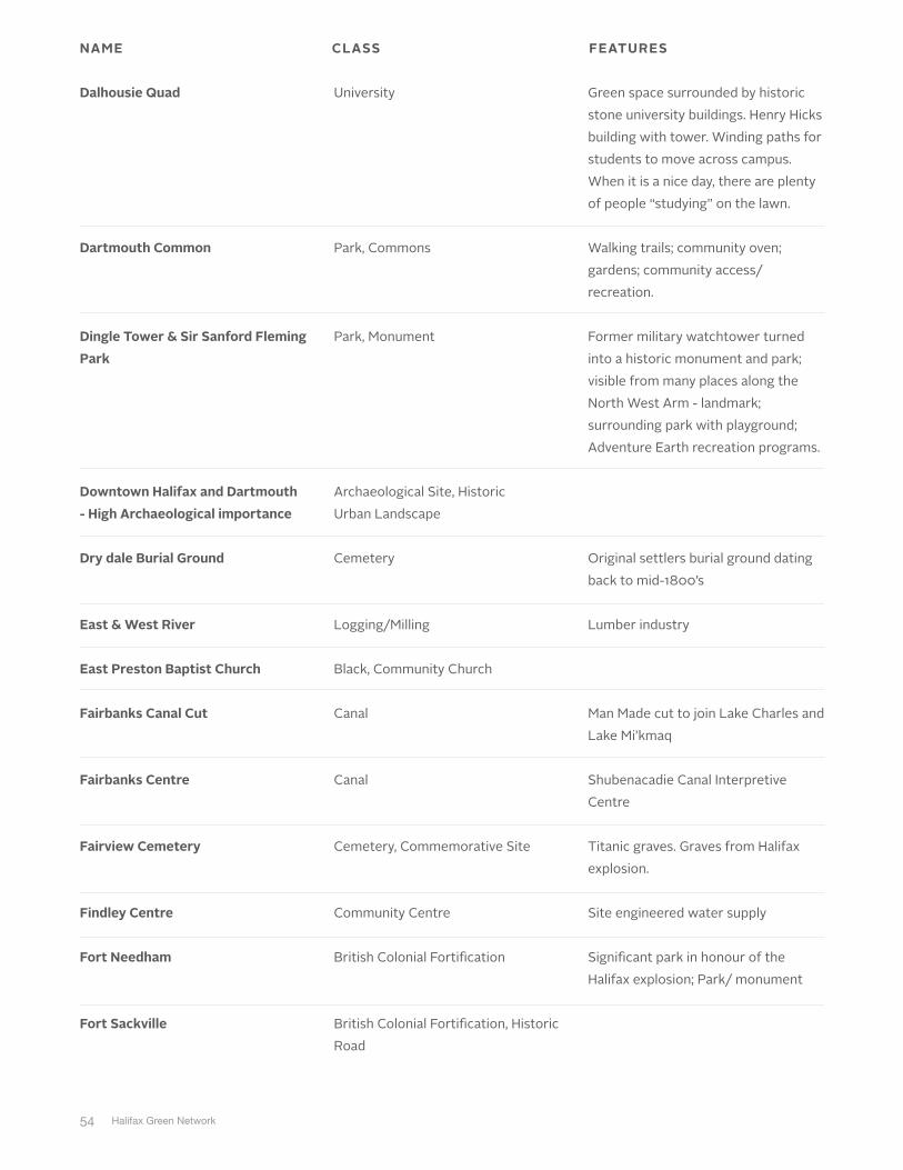
NAME CLASS FEATURES

53
Black Cultural Centre of Nova Scotia
Black Heritage @ Fletcher's Lake ("Baptizing Lake")
Bowstring Bridge
Canal Greenway
Causeway Road
Cemetery for Muslim Community
Cherry Brook United Baptist Church
Chezzetcook Inlet & Wetlands Christ Church Cemetery and Christ Church Anglican Church
Clam Harbour Beach
Cole Harbour Farm
Cornwallis Park
Black, Community Centre
Black Settlement, Spiritual Site
Bridge
Canal
Coastal Village
Cemetery
Black, Community Church
Acadian, Coastal Village
Church, Cemetery
Fishing, Beach
Agriculture
Railway, Park
Only museum solely featuring African Nova Scotia history and culture.
Magnificent arched highway bridge due to be replaced. Its replacement should be worthy of its predecessor Could the existing arch be re-used for a trail bridge?
Starr Factory site. Shubenacadie canal incline plane. Locks (relics underground). 2004 report on this.
Fishing shacks and causeway.
New within the last 10 years; owned by Muslim community and used for their burials; land previously owned by a resident of Upper Hammonds Plains.
Black community
Large salt marsh with Acadian heritage.
Historic churchyard, cemetery, and streetscape evoke New England small town.
Farm/ educational centre; schools take kids on trips here for a taste of agriculture in the suburbs; historic farm.
Train station/hotel and park complex built by CNR. Railway garden park. Edward Cornwallis statue– relates to founding of Halifax.
NAME CLASS FEATURES
54 Halifax Green Network
Dalhousie Quad
Dartmouth Common
Dingle Tower & Sir Sanford Fleming Park
Downtown Halifax and Dartmouth - High Archaeological importance
Dry dale Burial Ground
East & West River
East Preston Baptist Church
Fairbanks Canal Cut
Fairbanks Centre
Fairview Cemetery
Findley Centre
Fort Needham
Fort Sackville
University
Park, Commons
Park, Monument
Archaeological Site, Historic Urban Landscape
Cemetery
Logging/Milling
Black, Community Church
Canal
Canal
Cemetery, Commemorative Site
Community Centre
British Colonial Fortification
British Colonial Fortification, Historic Road
Green space surrounded by historic stone university buildings. Henry Hicks building with tower. Winding paths for students to move across campus. When it is a nice day, there are plenty of people “studying” on the lawn.
Walking trails; community oven; gardens; community access/ recreation.
Former military watchtower turned into a historic monument and park; visible from many places along the North West Arm - landmark; surrounding park with playground; Adventure Earth recreation programs.
Original settlers burial ground dating back to mid-1800’s
Lumber industry
Man Made cut to join Lake Charles and Lake Mi’kmaq
Shubenacadie Canal Interpretive Centre
Titanic graves. Graves from Halifax explosion.
Site engineered water supply
Significant park in honour of the Halifax explosion; Park/ monument
NAME CLASS FEATURES

55
French Village
Fultz Corner
Gate of Heaven Cemetery
George's Island
George's Island- National Historic Site
Grand Desert
Granville Square
Halicy House
Halifax Commons
Hammonds Plains 1st Nations
Herring Cove fishing village
Highway 333 old fish housing being restored between Glen Haven and Seabright
Historic Rail station on Bedford Highway
French Protestant, long lot subdivision
Historic Road
Cemetery
British Colonial Fortification
National Historic Site
Acadian, Coastal Village
Public Square
Railway
Park, Commons
Mi’kmaq Use
Coastal Village
Coastal Village
Railway
Lot patterns reflective of style of economic function of French Protestant settlers. Elongated lots allowed for community access to fishing, farming, and forestry.
Fultz house is gateway to Sackville. It is now a community museum. It marks the beginning of Old Sackville Rd former thoroughfare to the Valley. Old Sackville Rd retains original alignment to Middle Sackville at Oland’s Farm.
Military outpost; snakes.
Acadian community with prominent brick historic church.
One of the only pedestrian streets in Halifax. Is an important cultural space in association with NSCAD and Historic Properties.
The old railway station is now a restaurant.
NAME CLASS FEATURES

56 Halifax Green Network
Hydrostone
Indian Burial Mound
Jefferson Property
Kerhn Swamp
Lawlor's Island
Lawrencetown Beach
Lawrencetown Salt Marshes
Lock 1
Lock 2
Lock 3
Long Beach
Lucasville
National Historic Site
Mi’kmaq Spiritual Site
Archaeological Site
Mi’kmaq Use
Quarantine Site
Beach
Mi’kmaq Use, Agriculture, Fishing
Canal
Canal
Canal
Beach
Black Settlement
Former community of Richmond including Needham Park and institutional buildings.
In 1986, an Indian Burial Mound was discovered on the Shad Bay Subdivision, as it was being excavated for development. The NS Museum halted the development. The County of Halifax acquired the site through the Parkland Dedication Program.
Archaeological significance.
Wetlands forming headwaters of Morris and Russell Lakes; Native lands, medicinal plants nearby.
The Island was used as an area for quarantine for those with influenza or other diseases.
Known for surfing; beaches; boardwalk.
Restored Canal
Long Beach
Strong sense of community; many generations of family; community owned; one of the few Black communities with its own centre; Lucasville Baptist Church; subdivision development infringing on the Black community; no green space.
NAME CLASS FEATURES

57
Maroon Hill
Maroon Village
Martinique Beach
Martinique Beach
McNab's Island
Melville & Deadman's Island
Memory Lane Historic Village
Mi'kmaq community at Tuft's Cove
Millbrook Sheet Harbour
Mineville Road & Two Rivers Village Park
Moose River Heritage Site, gold mine
Mooseland Gold Mines
Moser Limestone
Munroe Subdivision
Black Settlement
Black Settlement
Coastal Village
Beach
British Colonial Fortification
National Historic Site
Community Museum
Mi’kmaq Occupancy
Coastal Village, Logging, Milling, Fishing
Park
Mining, Gold
Mining, Gold
Industrial Site
Black Settlement
Maroons migrated to this area; later became a race track, and later became Berry Hills S/D.
1800’s Maroons migration from Jamaica; 1st North Preston village; colonial.
Long curved beach extending south of a RAMSAR conservation site (migratory wetland). Nearby subdivision has added some housing of a controversial design.
British military buildings
Latest National Historic Site. Very significant layers of history mostly relating to a prison on Melville for POW’s during War of 1812. Also American POWs buried on Deadman’s Island.
Archaeological site; continuous use; resource rich; transportation routes.
Central park in the Mineville area; access to river.
Current and historical gold extraction.
Limestone manufacturing plant. In operation for over 50 years.
One of the only remaining streets in Beechville were the original African NS residents of Beechville.
NAME CLASS FEATURES

58 Halifax Green Network
Musquodoboit Harbour Community Centre
Musquodoboit Railway system
Native Reserve
Oakridge Memory Gardens
Old Halifax Road
Old Icelandic area being logged
Old Musquodoboit Railway
Old Railway Bridge
Paper Mill Lake Watershed and Kearney Run
Peggy's Cove
Petroglyphs
Point Pleasant Park
Community Centre
Railway
M’kmaq, Reserve
Cemetery
Historic Road
Icelandic Settlement, Logging
Railway
Railway
Logging, Milling
Preservation Area, Peggy’s Cove Commission
Mi’kmaq Spiritual Site
Park
Known existence of Native Reserve off the Hammonds Plains Road.
Cemetery
Historic road linking the city of Halifax and the South Shore Nova Scotia.
Old station houses and museum, with short length of track and old railcars. Potential for metro-rail tourism. Also, much of the route has been converted to a trail.
Through tress bridge converted for trail, with views of river and wetlands. The Province has proposed a freeway bypass through the area.
Military fortifications such as Cambridge Battery, Martello Tower, Fort Ogilvie, etc.; Hurricane Juan impacts; Regional natural park; Point Pleasant Park Comprehensive Master Plan.
NAME CLASS FEATURES

59
Post-explosion Halifax
Prince's Lodge on Bedford Highway- ties to Duke of Kent Estate at Hemlock Ravine
Prospect High Head
Prospect Village
Public Gardens
Rainbow Haven Beach
Red bridge pond
Ropes Factory
Schmidtville Conservation District
Settlement of War of 1812 Refugees
Main Street Commercial/ Residential
Park, Commemorative Site, Park
Mi’kmaq Use
Coastal Village
National Historic Site
Beach
Canal
Industrial Site
Heritage Property Act Site
Black, Historic Cemetery
Halifax was designed after the explosion. In 1920’s, many store buildings (institutional and residential) were erected with architectural details. Hydrostone, Acadia Square, St. Mark’s Church, court house, Needham explosion monument, are all part of this.
Prospect High Head is a coastal barren that is approximately 525 acres, which is very fragile to disturbance. It was traditionally used by the Mi’kmaq as an area for berry formation and evolved into use for agriculture in the 1800’s.
Classic coastal fishing village that formed in the mid 1800’s as the Port of Call for the North Atlantic fishing fleet. This community, according to recorded history supported a population of 4000 during Port of Call.
Beach
Home of Emmanuel Baptist Church (established by Richard Preston and others); African United Baptist Church (AUBA); Taylor Lake - was used for baptisms in past; Melvin Tract granted land to War of 1812 Refugees and their descendants.
NAME CLASS FEATURES

60 Halifax Green Network
Shannon Park
Shearwater Airport
Ship Harbour
Shore Club
Shubenacadie Canal
Shubie Park
South Barrington conservation district
St Margarets Bay
St. Mary's Basilica
St. Thomas Baptist Church
Sullivan's Pond
Tannery
DND Lands
DND Lands, Airport, DND Residential Subdivision
Coastal Village
Main Street Commercial Residential
Special Places Act Site, Canal
Canal, Park
Heritage Property Act Site
Coastal Village
Church
Black, Community Church
Public Square
Industrial Site
Military use. It is also a recreation hub (soccer fields, ball fields); future development, Canada Lands is now planning to develop 80 acres. 10 acres was given to the military.
Military tradition, in terms of airbase and surrounding residential development.
Steep cliff and ocean inlet as Hwy #7 curves. Dramatic views. Also, an older house at the bend adds a touch of human heritage.
Lobster Restaurant
Provincially designated under the Special Places legislation.
Historical canal system; walking trails; many recreational uses; outdoor recreation hub for Dartmouth.
One of the oldest, most beautiful churches in Halifax; mass is still held there, however it is a large tourist destination and parish centre.
200 years old
Dartmouth’s public plaza- fireworks, civic events, walkway. Geese, gathering place, and a feature of Dartmouth public art.
This is the location of an old tannery.
NAME CLASS FEATURES

61
Taylor Head
The site of the former North Street Rail Station- 1877_to_1920
Trail follows alignment of dam (near Cole Harbour, Rainbow Haven). Remnants of landscape. Dam + hayfield
Train Station
Uniacke Square
Union Cemetery
Universities
Upper Hammonds Plains Community Centre
Victoria Road United Baptist Church
The Citadel and its viewsheds. Majority of visitors today go to the outside of the fort, not inside. Views are very important.
Bay of Islands
Long Hill View of Cole Harbour
Beach
Railway, Commemorative Site
Fishing, Agriculture, Railway
Railway
Black Community, Residential Subdivision
Cemetery
University
Black Settlement
Black, Community Church
Viewsheds
View Sheds
View Sheds
Magnificent natural peninsula with white sand beach and wetlands. Provincial park.
Old train station for South Shore railway.
Area where many residents of Africville were relocated. Major African NS community in urban area of Halifax.
Residential patterns; educational; cultural; recreational; arts.
Formerly a segregated schoolhouse for the Black community - a one-room schoolhouse.
One of the African United Baptist Churches (A.U.B.A).
Water views of low lying islands along the Eastern Shore.
NAME CLASS FEATURES

62 Halifax Green Network
Highway 3
Musquodoboit Harbour to Cow Bay
Admiral Cove Park
Waterfront (historic)
Waverley Gold Mines
Wellington Locks
Westmount Subdivision
Whalers Nantucket
Windsor/ Hantsport Railway
Woodlawn Cemeteries "Babes in the Woods"
York Redoubt
View Sheds, Coastal Village
View Sheds, Coastal Village
View Sheds, Park, Scenic Coastal Road
Dock
Mining, Gold
Canal
CMHC Garden Subdivision
British Colonial Fortification, Coastal Village
Railway
Cemetery
British Colonial Fortification
Scenic ocean view drive from Head of St Margaret’s Bay to Hubbards.
Cultural landscape under threat.
Pier (Immigration), shipbuilding, recreation, tourism, shopping.
Early mining industry; Waverley formed as a mining community.
Archaeological significant; rebuilt locks from Shubenacadie Canal System; remnants of old fish hatchery; confluence of two main rivers.
Garden suburb planning. CMHC development. Post WWII.
No longer in use. Could be significant to Rails to Trails.
Important site of significant British Military history.
NAME CLASS FEATURES

63
ISSUES• Stakeholder engagement has raised a high degree of interest across the HRM,
and residents have expressed their desire to be engaged throughout the project.
• Rural coastal settlements are considered special places that have value to a community’s identity and sense of place. These settlements must be protected from urban sprawl and development that is out of scale with the community character. There is special concern regarding communities from Hubbards over to Tantallon. Current development pressures threaten to have negative impacts on the critical character of Sambro, Prospect, and SMB.
• Citizens are very concerned about ‘urban sprawl,’ and its effect on their communities’ sense of place and the resulting loss of historic community character.
• Access to water - a traditional value in Nova Scotia - is being increasingly threatened by private development; policies need to be established to protect access to lakes, rivers, beaches, and open water.
• Viewsheds from land to water and from water to land (in a province that is defined by land and sea) are key, character-defining elements in the HRM; their protection should be a high priority.
• Stakeholders place a high value on historic main streets; the core of Halifax including the downtown, docklands, historic residential communities, and parks.
• Residents consider the trail systems, in urban areas and in regional parks, as key cultural components of their communities.
OPPORTUNITIES• Ongoing engagement with communities to identify important cultural
landscapes will provide the HRM with the opportunity to develop a comprehensive database of these resources. This will enable the prioritization of their significance, and potential policies and programs for their management and long term protection.
• Stakeholder engagement will continue to strengthen community cohesiveness,respect for the historic character of communities, and the unique resources of the HRM.
• The protection of cultural landscapes in the HRM will support the valuable tourism market and provide opportunities for small business development throughout the HRM.

64 Halifax Green Network
3.6 OTHERS• Important to consider previous engagement initiatives and outcomes,
including:• RP+5 (Regional Municipal Strategy)
• 2014 Eastern Shore Community Consultation (Eastern Shore HRM Strategic
Plan)
• Community Visioning (Vision and Action Plan for seven communities)

65
What We Heard
Vision Components
4

66 Halifax Green Network
As part of the Phase 1 engagement process, participants were asked to express key words and/or ideas about their preferred future green network. Comments on the vision were obtained during the open houses, pop-ups, stakeholder workshops, interviews, surveys, and the online engagement platform.Participants envisioned an open space network that protects the environment (biodiversity, water, etc.), and provides a diversity of recreation opportunities, with extensive, accessible trails, green spaces, water bodies, and rivers, that are connected to and through surrounding communities. Participants felt strongly that the open space network would not only support a healthy lifestyle, provide food and clean water, but would also provide regional economic benefits. Transit accessibility to the network that could ensure broad and equitable enjoyment of the network, consistently surfaced as an important community value. Participants also suggested that the natural systems and cultural landscapes were intrinsic components of the network that uniquely contribute to the character, history, and beauty of the HRM.
Figure 2. Open Space Network Vision Word CloudThe ‘word cloud’ (Figure 2) was generated from the comments provided over the course of Phase 1 engagement. The words that are displayed larger in size and with greater prominence reflect the words that appear more frequently in the comments received. The words, “natural, connected, open, space, wilderness, wildlife, development, trails, and city” were the most frequent.

67
QUOTES“I can be downtown, jump on my bike and in 30 min be sitting on a rock in the middle of a lake with only trees around me. I envision that the easy access to wilderness and open space is celebrated in HRM. I envision Halifax being put on the map as a “Wilderness City”.
“Halifax is a place where you can jump in a sail boat down town and in 30 min you are on a secluded island beach. Halifax has a bus that takes you to a coastal cliff where you can watch the waves crash and have a camp fire. After a short walk you can pick wild chanterelle mushrooms in Halifax. Halifax has many beaches and lakes and islands to explore. Halifax has all the urban amenities but you don’t have to give up rural life and wilderness recreation. Halifax has an urban farm and connection with rural crafts and farms. My vision of Halifax is one where children and cyclists feel safe on the streets where there are many wilderness areas which creating a green belt around Halifax. My vision for Halifax is one where deer and citizens swim between the islands.”
“The backlands are a connection of the Purcell’s Cove and Herring Cove Communities. This could be emphasized if made public, encourage more hiking and biking between communities.”
“An active transportation network connecting each community, similar to the Chain of Lakes Trail. Hiking trails, mountain biking trails and canoe/kayak friendly areas throughout appropriate areas like Blue Mountain/Birch Cove Wilderness Area and Long Lake. These areas are under-utilized and under-developed as far as proper recreational trail development, parking and boat launching. Halifax has many natural assets that if properly developed can distinguish Halifax the way it should be.”

68 Halifax Green Network
How We Used The Input
5
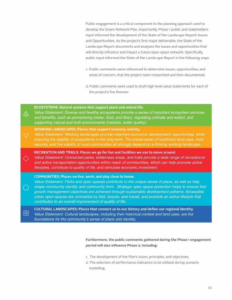
69
Public engagement is a critical component to the planning approach used to develop the Green Network Plan. Importantly, Phase 1 public and stakeholders input informed the development of the State of the Landscape Report: Issues and Opportunities. As the project’s fi rst major deliverable, the State of the Landscape Report documents and analyzes the issues and opportunities that will directly infl uence and impact a future open space network. Specifi cally, public input informed the State of the Landscape Report in the following ways:
1. Public comments were referenced to determine issues, opportunities, and areas of concern, that the project team researched and then documented.
2. Public comments were used to draft high level value statements for each ofthe project’s fi ve themes:
Furthermore, the public comments gathered during the Phase 1 engagement period will also infl uence Phase 2, including:
1. The development of the Plan’s vision, principles, and objectives.2. The selection of performance indicators to be utilized during scenario
modelling.

70 Halifax Green Network
contactinformation
510 255 17th Ave SW
Calgary, AB T2S 2T8
T 403 228 1336
C 403 472 1574
F 403 228 1320
Copyright © 2015 O2 Planning + Design Inc.
The information contained in this document is the intellectual property of O2
Planning + Design Inc.Reproduction of portions of this document for use by the
Client during the proposal evaluation is permitted. Reproduction of any portion of
this document or use of the intellectual ideas contained within it for any other
purpose is prohibited unless O2 is subsequently retained by the Client for the work
described within this proposal.