Embed Size (px)
Citation preview
ORDINANCE NO. 509 -704
AN ORDINANCE OF THE CITY COUNCIL OF THE CITY OF PEARLAND,
TEXAS, AMENDING ORDINANCE NO. 509, THE LAND USE AND URBAN
DEVELOPMENT ORDINANCE OF THE CITY OF PEARLAND, TEXAS, FOR
THE PURPOSE OF CHANGING THE CLASSIFICATION OF CERTAIN REAL
PROPERTY LOCATION BEING 39.50 ACRE TRACT OF LAND BEING OUT OF
THE D. H. M. HUNTER SURVEY, ABSTRACT 76, BEING A PORTION OF THE
SAME 181. 6209 ACRE SURVEY AS RECORDED IN VOLUME 1596, PAGE 93OF THE BRAZORIA COUNTY DEED RECORDS; AND 83. 83 ACRE TRACT OF
LAND BEING OUT OF THE D. H. M. HUNTER SURVEY, ABSTRACT 76 ANDTHE H. T. &B. R. R. COMPANY SURVEY, ABSTRACT 233, BEING A PORTION
OF THE SAME 181. 6209 ACRE SURVEY RECORDED IN VOLUME 1596, PAGE 93 OF THE SAME BRAZORIA COUNTY DEED RECORDS
APPLICATION NO. 1156) FROM CLASSIFICATION SUBURBAN
DEVELOPMENT DISTRICT ( SD) TO PLANNED UNIT DEVELOPMENT ( PUD)
AT THE REQUEST OF PAUL GROHMAN, AGENT FOR SUE MORRISON,
OWNER, PROVIDING FOR AN AMENDMENT OF THE LAND USE DISTRICT
MAP; CONTAINING A SAVINGS CLAUSE, A SEVERABILITY CLAUSE, AN
EFFECTIVE DATE AND OTHER PROVISIONS RELATED TO THE SUBJECT.
WHEREAS, Paul Grohman, Agent for Sue Morrison, Owner, filed on February
16, 2004, an application for amendment pursuant to Section 28 of Ordinance No. 509,
the Land Use and Urban Development Ordinance of the City, for approval of a change
in the land use as provided for in said Section 28, said property being legally described
in the original applications for amendment attached hereto and made a part hereof for
all purposes as Exhibit "A "; and
WHEREAS, on the15th
day of March, 2004, a Joint Public Hearing was held
before the Planning and Zoning Commission and the City Council of the City of
Pearland, Texas, notice being given by publication in the official newspaper of the City,
the affidavit of publication being attached thereto and made a part hereof for all
purposes, as Exhibit "B ", said call and notice being in strict conformity with provisions of
Section 28.3 and 28.4 of Ordinance No. 509; and
WHEREAS, on the12th
day of April, 2004, the Planning and Zoning Commission
of the City submitted its report and recommendation to the City Council regarding the
proposed amendment application by, Paul Grohman, Agent for Sue Morrison, Owner,
1
ORDINANCE NO. 509 -704
whereby the Commission recommendation to deny for the change of classification for
the property described in Exhibit " A" from its existing classification of Suburban
Development District (SD) to Planned Unit Development (PUD); and
WHEREAS, upon receipt of the report from the Planning and Zoning
Commission, the City Council considered this application and the recommendation of
the Planning and Zoning Commission at a regular meeting on April 12, 2004; and
WHEREAS, the City Council having fully heard the testimony and argument of all
interested parties, and having been fully advised in the premises, finds that in the case
of the application of Paul Grohman, Agent for Sue Morrison, Owner, presented which,
in the judgment of the City Council, would justify the approval of said application; now,
therefore,
BE IT ORDAINED BY THE CITY COUNCIL OF THE CITY OF PEARLAND, TEXAS:
The following described property located within the corporate City limits of the
City of Pearland, Texas, and presently classified as Suburban Development District
SD) to Planned Unit Development ( PUD), such property being more particularly
described as:
39.50 acre tract of land being out of the D. H. M. Hunter Survey, Abstract76, being a portion of the same 181. 6209 acre survey as recorded inVolume 1596, Page 93 of the Brazoria County Deed Records; and 83.83acre tract of land being out of the D. H. M. Hunter Survey, Abstract 76 andthe H. T. & B. R. R. Company Survey, Abstract 233, being a portion of thesame 181. 6209 acre survey recorded in Volume 1596, Page 93 of the
Brazoria County Deed Records.
The City Council of the City of Pearland finds and determines that the recitations
in the preamble hereof are true and that all necessary prerequisites of law have been
accomplished and that no valid protest of the proposed change has been made. The
2
ORDINANCE NO. 509 -704
City Council further finds and determines that there has been compliance with the
mandates of law in the posting and presentation of this matter to the Planning and
Zoning Commission and to the City Council for consideration and decision.
The City Council of the City of Pearland finds and determines that the
amendment adopted herein promotes the health, safety, and general welfare of the
public and is a proper valid exercise of the City's police powers.
IV.
If any section, subsection, sentence, clause, phrase, or portion of this Ordinance
is for any reason held invalid or unconstitutional by any court of competent jurisdiction,
such portion shall be deemed a separate, distinct, and independent provision and such
holding shall not affect the validity of the remaining portions thereof.
go
All rights and remedies, which have accrued in the favor of the City under this
Ordinance and its amendments thereto, shall be and are preserved for the benefit of
the City.
VI.
The City Secretary is hereby directed to cause to be prepared an amendment to
the official Land Use District Map of the City, pursuant to the provisions of Section 2 of
Ordinance No. 509 and consistent with the approval herein granted for the
reclassification of the herein above described property.
OTM
This Ordinance shall become effective after its passage and approval on second
and final reading.
3
ORDINANCE NO. 509 -704
PASSED, APPROVED, and ADOPTED on First Reading this 12th day of
Apri 1 , 2004.
pyx) t-
TOM REID
MAYOR
ATTEST:
PASSED, APPROVED, and ADOPTED on Second and Final Reading this26th day of April ' 2004.
ATTEST:
SU
APPROVED AS TO FORM:
DARRIN M. COKER
CITY ATTORNEY
TOM REID
MAYOR
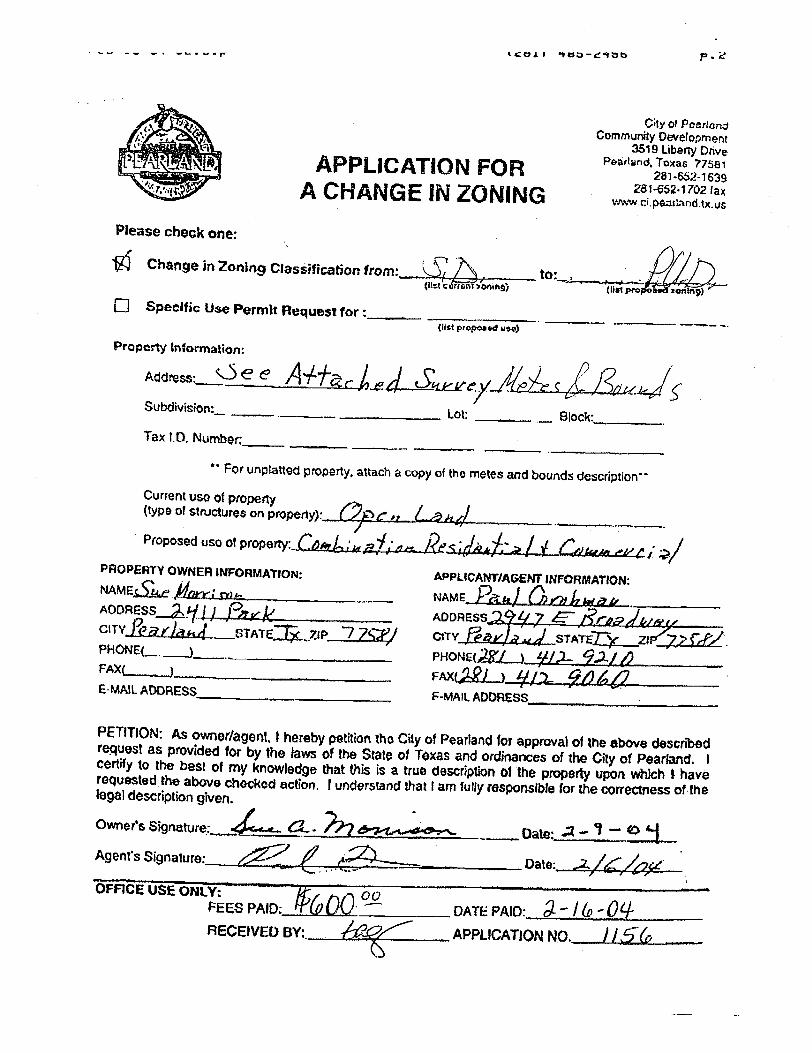
Please check one:
4COI r ' VOD - 44Ab P. e
City of Peertor•.dCommunity Development
3519 Liberty Drive
APPLICATION FOR Peartand, Toxas 77581APPLICATION i281- 652 -1639
A CHANGE IN ZONING v' vraipaartandtxrus
70 Change in 7-oning Classification from: _ to• 1lst c rrs st soningj o. pro : antn9)
Specific Use Permit Request forlist proposed usa) — —'.
ProPcrty Information:
subdivision•
Tax I. D. Nurnber:
Lot: — Block:`
For unplatted property, attach a copy of the metes and bounds description"
Current use of propertytype of structures on property)--
Proposed use of property: –caaPROPERTY OWNER INFORMATION: NAME t( e f , h
AODRESS 1 j - B ) l
CITY ` STATE t 7tP
PHONE( —. ^)
FAX( ____)_
E -MAIL ADDRESS
APPLICANT /AGENT INFORMATION: tvAME
M I.. %
2., rr71r
ADDRESS
ctTY STA-
rErnn.21
PHONE(R, -i &-- j.z. c___
FAX( J--- y -, Z.
F -MAIL ADDRESS
PETITION: As ownor /agent, i hereby petition tho City of Pearland for approval of the above describedrequest as provided for by the laws of the State of Texas and ordinances of the City of Pearland. I
certify to the best of my knowledge that this is a true description of the property upon which t haverequested the above chocked action. I understand that I am fully responsible for the correctness of thelegal description given.
Owner's Signature: %.- Date- . 2 g "
Agent's Signature: Date : - 2,
t: pv
PEES PAID: % 000. DATE PAID:_
RECEIVED BY :. APPLICATION NO.
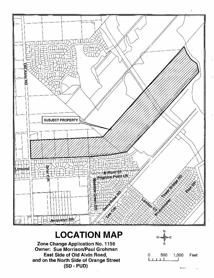
SUBJECT PROPERTY
HEM-1.1
LOCATION MAPZone Change Application No. 1156
Owner: Sue Morrison /Paul Grohman
East Side of Old Alvin Road,
and on the North Side of Orange Street
SD - PUD)
NN
W+ E
S
0 500 1, 000 FeetI I I 1 1 I
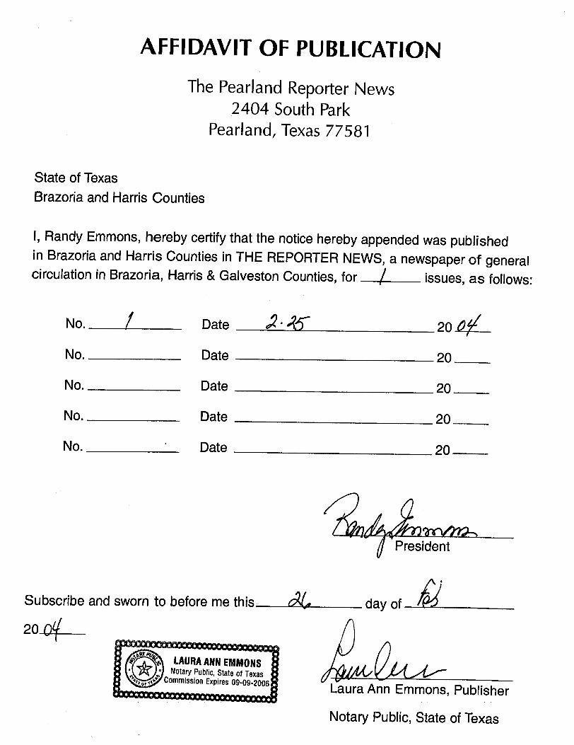
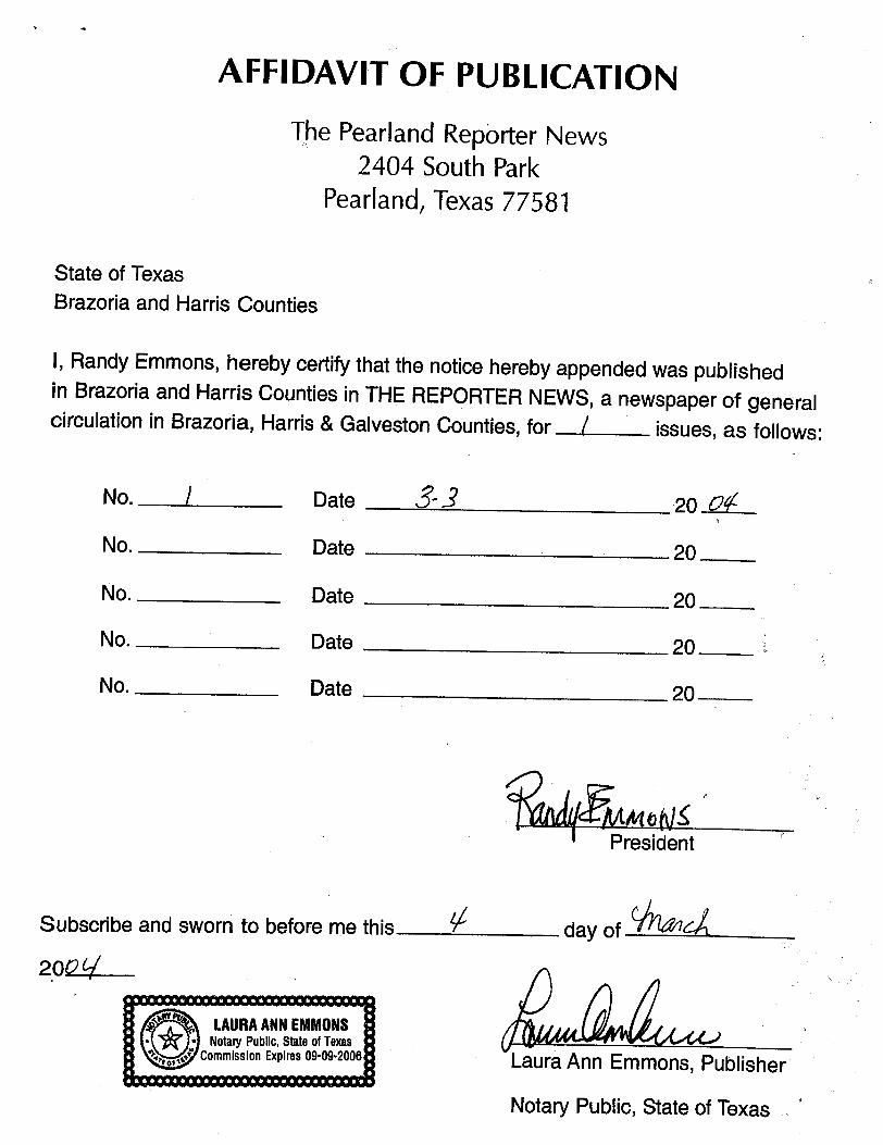
AFFIDAVIT OF PUBLICATION
The Pearland Reporter News2404 South Park
Pearland, Texas 77581
State of Texas
Brazoria and Harris Counties
I, Randy Emmons, hereby certify that the notice hereby appended was publishedin Brazoria and Harris Counties in THE REPORTER NEWS, a newspaper of generalcirculation in Brazoria, Harris & Galveston Counties, for issues, as follows:
No. _ Date 45- 20 AIV-
No. Date 20
No. Date 20
No. Date 20
No. Date 20
A 1. President
Subscribe and sworn to before me this- 01 day of A
Laura Ann Emmons, Publisher
Notary Public, State of Texas
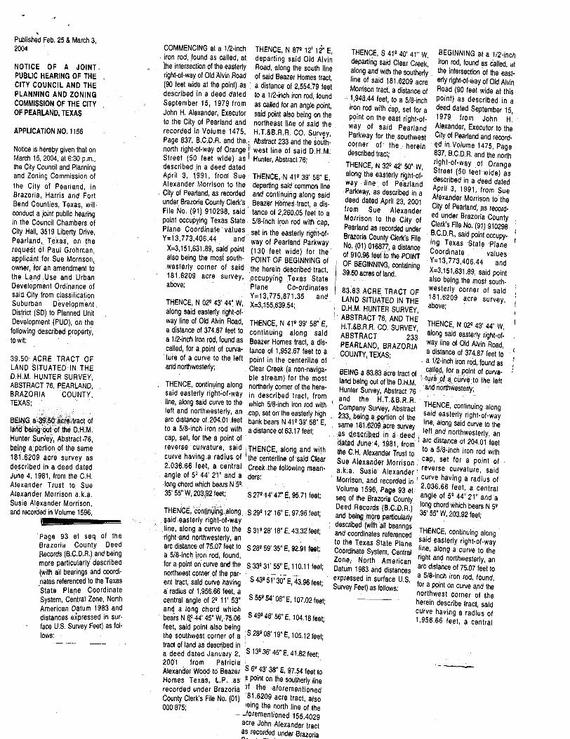
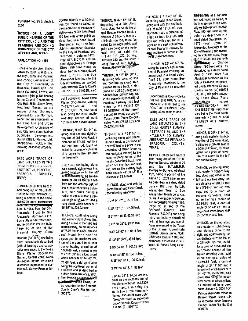
Published Feb. 25 & March 3, 2004
NOTICE OF A JOINT.
PUBLIC HEARING OF THECITY COUNCIL AND THEPLANNING AND ZONINGCOMMISSION OF THE CITYOF PEARLAND, TEXAS
APPLICATION NO. 1156
Notice is hereby given that onMarch 15, 2004, at 6: 30 p. m., the City Council and Planningand Zoning Commission ofthe City of Pearland, inBrazoria, Harris and FortBend Counties, Texas, will•
conduct a joint public hearingin the Council Chambers of
City Hall, 3519 Liberty Drive, Pearland, Texas, on therequest of Paul Grohman, applicant for Sue Morrison,
owner, for an amendment tothe Land Use and UrbanDevelopment Ordinance of
said City from classificationSuburban Development.
District ( SD) to Planned UnitDevelopment ( PUD), on the
following described property, to wit:
39. 50 ACRE TRACT OF
LAND SITUATED IN THED. H. M. HUNTER SURVEY, ABSTRACT 76 PEARLAND, BRAZORIA COUNTY,
TEXAS;
BEING a 3%50,9re tract ofland being -out of the D: H. M. Hunter Survey, Abstract ,76, being a portion of the same181. 6209 acre survey asdescribed in a deed datedJune 4, 1981, from the C. H.
Alexander Trust to. Sue
Alexander Morrison a. k. a. Susie Alexander Morrison,
and recorded in Volume 1596,
1
Page 93 et seq of theBrazoria County DeedRecords ( B.C. D. R.) and beingmore particularly describedwith all bearings and coordi-
nates referenced to the Texas
State Plane CoordinateSystem, Central Zone, North
American Datum 1983 and
distances expressed in sur-
face U. S. Survey feet) as fol- lows:
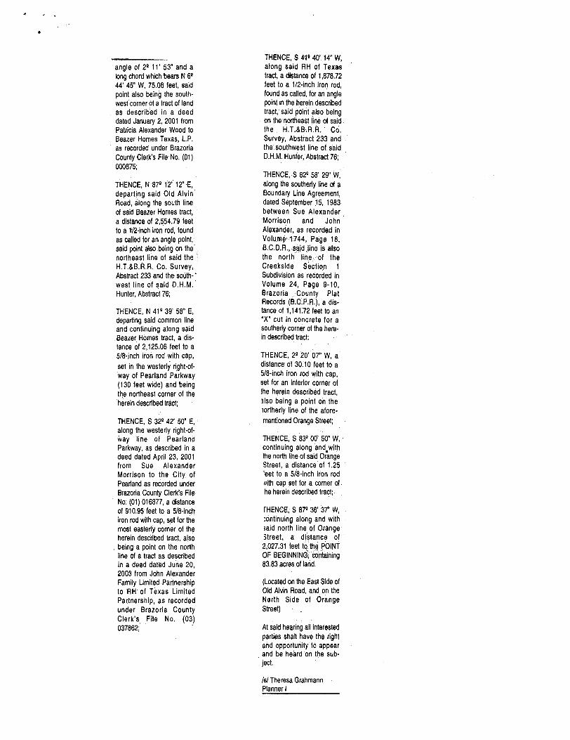
COMMENCING at a 1/ 2 -inchiron rod, found as called, at
the
THENCE, N 871 12' 12" E,
departing said Old AlvinTHENCE, S 41140' 41" W, BEGINNING at a 112 -inchdeparting Clear iron rod, found
intersection of the easterly Road, along the south linesaid Creek, as called, at
along and with the southerly the intersection of the east- right-of-way of Old Alvin Road90 feet wide at the point) as
of said Beazer Homes tract, a distance of 2, 554. 79 feet
line of said 181. 6209 acre erly right-of--way of Old Alvin
described in a deed dated to a 1/ 2 -inch iron rod, found Morrison tract, a distance of Road ( 90 feet wide at this1, 948.44 feet, to a 5/ 8 -inch point) as described inSeptember 15, 1979 from as called for an angle point, a
iron rod with cap, set for a deed dated September 15, John H. Alexander; Executor said point also being on the point on the east right -of- 1979 from John H. to the City of Pearland and northeast line of said the way of said Pearland Alexander, Executor to therecorded in Volume 1475, Page 837, B. C. D. R. and the..
H. T. &B. R: R. CO. Survey, Abstract 233 and the south-
Parkway for the southwest City of Pearland and record -
north right -of -way of Orange west line of said D. H. M. corner of the , herein ed in. Volume 1475, Pagedescribed tract; 837, B. C. D. R. and the northStreet ( 50 feet wide) as
described in a deed dated1 Hunter, Abstract 76;
THENCE, N 32Q 42' S0^ W, right -of -way of Orange
April 3, 1, 991, from Sue THENCE, N 411 39' 58" E, along he easterly right-of- Street ( 50 feet wide) as9 ydescribed in a deed datedAlexander Morrison to the
City of Pearland, as recordeddeparting said common lineand continuing along said9 9
way line of PearlandApril 3 1991, from SueParkway, as described in aAlexander
under Brazoria County Clerk' s Beazer Homes tract, a dis Morrison to thedeed dated April 23, 2001City of Pearland, as recordfromFile No. ( 91) 910298, said tance of 2, 260. 05 feet to a Sue Alexander - ed under Brazoria Countypoint occupying Texas State
Plane Coordinate values5/ 8- inch iron rod with cap, Morrison to the City ofy
Clerk's File No. ( 91) 910298 ; Pearland as recorded underY = 13, and
set in the easterly right -of- Brazoria County C B. C. D. R., said pointoccupyX =3, 151, 631. 89, said point51, 631. 89,
way of Pearland Parkway130 feet wide) for the
r
No. ( 01) 016877, a distance mg Texas State PlaneCoordinate
also being the most south- westerly
POINT OF BEGINNING ofof 910.96 feet to the POINT . values
Y- 13, 773, 406. 44 and
OF BEGINNING, containingcorner of said
181. 6209the herein described tract, X_ 3, 151, 631. 89, said point
acre survey,' above;
occupying Texas State also being the most south. Plane Co- ordinates
83, 83 ACRE. TRACT OF westerly corner of saidsTHENCE, N 02 43' 44" W,
Y= 13, 775, 871. 35 and
X= 3, 155, 639. 54;, LANDSITUATEDIN THE 181. 6209 acre survey,
above; l
along said easterly right-of- D. H. M. HUNTER SURVEY, i
way ine of Old Alvin Road, y 4THENCE, N 41 39' 58" E, ABSTRACT 76, AND THEH. T. &B.R. R. CO. SURVEY, THENCE, N 02143' 44" W, t
a distance of 374.87 feet to
a 1/ 2- inch iron rod, found ascontinuing along said ABSTRACT 233 along said easterly right -of-
called, for a point of curva- Beazer Homes tract, a dis• tance of 1, 952. 67 feet to a
PEARLAND BRAZORIA way line of Old Alvin Road, COUNTY, TEXAS; a distance of 374.87 feet to
r
ture of a curve to the left point in the centerline of a 1/ 2 -inch iron rod, found as ' and northwesterly; Clear Creek ( a non - naviga- BEING a 83.83 acre tract of called, for a point of curva- THENCE, continuing along
ble stream) for the most
northerly corner of the here- land being out of the D. H. M. . ture ;af acurve to the left
Hunter Survey, Abstract 76 and northwesterly; said easterly right-of- wayline; along said curve to the
in described tract, fromwhich 5/8 -inch iron rod with `
and the H. T. &B. R. R.
Company Survey, Abstract THENCE, continuing alongleft and northwesterly, an204.01 feet
cap, set on the easterly highbank bears N 41139' 58" E,
X33, being a portion of the said easterly right -of -wayline, along said curve to the
to
adistancench on rod with a distance of 63. 17 feet; same 181. 6209 .acre survey
as described in- 6 deed left and northwesterly, ancap, set, for the a point ofdated June 4, 1 -
6
from I arc distance of 204.01 feetreverse curvature, said THENCE, along and with the C.H. Alexander Trust to to a 5/ 8- inch iron rod withcurve having. a radius of , the centerline of said Clear Sue Alexander Morrison cap, set for a point of - 2. 036. 66 feet, a central Creek the following mean- a. k: a. Susie Alexander reverse curvature, saidangle of 51 44' 21" and a ' ders: Morrison, and recorded r curve having a radius oflong chord which bears N 51. 35' 55" W, 203.92 feet; S 27114' 47" E, 95. 71 feet;
Volume 1596, Page 93 et 2036.66 feet, a centralseq of the Brazoria County angle of 51 44' 21" and a
THENCE, conttnpmg.along , S P9112' 16" E, 97.96 feet; Deed Records ( B. C. D. R.) long chord which bears N 51and being. mprg particularly 36557 W, 203. 92 feet; said easterly right -of -way
line, along a curve to the S 31128' 18" E, 43.37 feet; described ( with all bearingsand coordinates referenced THENCE, continuing along
right-and northwesterly, an
arc distance of 75.07 feet to S 28159' 35" E, 92.91 feet; to the Texas State Plane said easterly right- of- wayCoordinate System, Central line, along a curve to thea 5/ 8- inch iron rod, found,
for a point on curve and the S 33131' 55" E, 110. 11 feet; Zone; North American right and northwesterly, anDatum 1983 and distances arc distance of 75. 07 feet tonorthwest corner of the par-
ent tract, said curve having S 43151' 30" E, 43. 96 feet; a 5/ 8 -inch iron rod, found, expressed in surface U. S. for a point on curve and theSurvey Feet) as follows: a radius of 1, 956.66 feet, a
central angle of 21 11' 53" S 55154' 08" E, 107.02 feet; northwest corner of theherein describe tract, said
and a long chord whichbears N 6? 44' 45" W, 75:06 S 49148' 56" E, 104. 18 feet; curve having a radius of
1, 956. 66 feet, feet, said point also being
a central
the southwest corner of a • S 28108' 19" E, 105. 12 feet; tract of land as described ina deed dated January 2, , S 13136' 45" E, 41. 82 feet; 2001 from Patricia
Alexander Wood to Beazer S 6143' 38" E, 97. 54 feet tov
Homes Texas, L. P. as a point on the southerly linerecorded under Brazoria ) f the aforementionedCounty Clerk' s File No. ( 01) 181. 6209 acre tract, also000 875; ieing the north line of the
forementioned 155. 4029acre John Alexander tractas recorded under Brazoria
angle of 29 11' 53" and a
long chord which bears N 6944' 45" W, 75.06 feet, said
point also being the south - west corner of a tract of land
as described in a deed
dated January 2, 2001 fromPatricia Alexander Wood to
Beazer Homes Texas, L. P.
as recorded under Brazoria
County Clerk' s File No. ( 01) 000875;
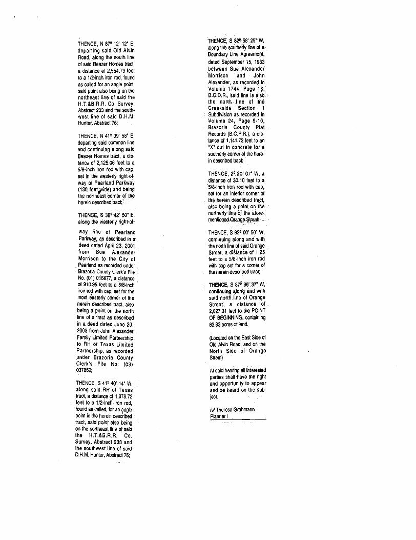
THENCE, N 879 12' 12" E,
departing said Old AlvinRoad, along the south lineof said Beazer Homes tract,
a distance of 2, 554. 79 feetto a 1/ 2 -inch iron rod, found
as called for an angle point, said point also being on thenortheast line of said the
H. T. &B. R. R. Co. Survey, Abstract 233 and the south -' west line of said D. H. M. Hunter, Abstract 76;
THENCE, N 419 39' 58 E,
departing said common lineand continuing along saidBeazer Homes tract, a dis-
tance of 2, 125.06 feet to a
5/ 8 -inch iron rod with cap,
set in the westerly right -of- way of Pearland Parkway130 feet wide) and being
the northeast corner of the
herein described tract;
THENCE, S 329 42' 50" E,
along the westerly right -of- way line of PearlandParkway, as described in adeed dated April 23, 2001
from Sue Alexander
Morrison to the City ofPearland as recorded under
Brazoria County Clerk's FileNo. ( 01) 016877, a distanceof 910.95 feet to a 5/8- inch
iron rod with cap, set for themost easterly corner of theherein described tract, also
being a point on the northline of a tract as described
in a deed dated June 20,
2003 from John Alexander
Family Limited Partnershipto RH of Texas Limited
Partnership, as recordedunder Brazoria CountyClerk' s File No. ( 03)
037862;
THENCE, S 419 40' 14" W,
along said RH of Texastract, a distance of 1, 878.72feet to a 1 / 2- inch iron rod, found as called, for an anglepoint in the herein described
tract, said point also beingon the northeast line of said
the H. T. &B -.R. R. Co.
Survey, Abstract 233 andthe southwest line of said
D. H. M. Hunter, Abstract 76;
THENCE, S 82158' 29" W,
along the southerly line of aBoundary Line Agreement, dated September .15, 1983between Sue AlexanderMorrison and John
Alexander, as recorded inVolume' 1744, Page 18, B. C. D. R., said line is, alsothe north line : of theCreekside Section 1
Subdivision as recorded inVolume 24, Page 9. 10,
Brazoria County PlatRecords ( B.C. P. R.), a dis- tance of 1, 141: 72 feet to anX" cut in concrete for a
southerly corner of the here- in described tract:
THENCE, 29 20'` 07" W, adistance of 30. 10 feet to a
5/ 8 -inch iron rod with cap, set for an interior corner of
the herein described tract,
also being a point on theiortherly line of the afore- mentioned Orange Street;
THENCE, S 839 00' 50" W,
continuing along and withthe north line of said Orange
Street, a distance of 1. 25eet to a 5/ 8 -inch iron rod
Nith cap set for a corner ofhe herein described tract;
THENCE, S 879 36'. 37" W,
ontinuing along and withSaid north line of Orangeitreet, a distance of
2, 027.31 feet to the POINTOF BEGINNING,` containing83.83 acres of land.
Located on the East Side of
Old Alvin Road, and on theNorth Side of OrangeStreet)
At said hearing all interestedparties shall have the right
and opportunity to appearand be heard on the sub- ject
s/ Theresa GrahmannPlanner I
AFFIDAVIT OF PUBLICATION
The Pearland Reporter News2404 South Park
Pearland, Texas 77581
State of Texas
Brazoria and Harris Counties
I, Randy Emmons, hereby certify that the notice hereby appended was publishedin Brazoria and Harris Counties in THE REPORTER NEWS, a newspaper of generalcirculation in Brazoria, Harris & Galveston Counties, for issues, as follows:
No. _ / Date 20 Z_
No. Date 20
No. Date 20
No. Date 20
No. Date 20
b . SPresident
Subscribe and sworn to before me this 1/
day of ( AM
200
i
Mres- L• Laura Ann Emmons, Publisher
Notary Public, State of Texas .
Published Feb. 25 & March 3, 2004
f BWMI OF . A JOINTPUBLIC HEARING OF THECITY COUNCIL AND THE
PLANNING AND ZONINGCOMMISSION OF THE CITYOF PEARLAND, TEXAS
APPLICATION N0, 1156
Notice is hereby given that onMarch 15, 2004, at 6: 30 p.m., the City Council and Planningand Zoning Commission oftthe City of Pearland; in, Brazoria, Harris.and FortBend Counties, Texas, will
conduct a joint public hearingin the Council Chambers of
City Hall, 3519 Liberty Drive, Pearland, Texas, on therequest of Paul Grohman,
applicant for Sue Morrison,
owner, for an amendment tothe Land Use and Urban
Development Ordinance of
said City from classificationSuburban DevelopmentDistrict ( SD) to Planned UnitDevelopment ( PUD), on the
following described property, to wit:
39. 50 ACRE TRACT OFLAND SITUATED IN THED. H. M. HUNTER SURVEY,
ABSTRACT 76, PEARLANQ, BRAZORIA COUNTY, TEXAS;
BEING a 39. 50 acre tract of
land. being out of the D. H. M. Hunter Survey, Abstract 76, being a portion of the same; 181; 6209 acre Awma + mssdJune 4, 1981, from the C. H'. Alexander Trust to SueAlexander Morrison a. k. a. Susie Alexander Morrison,
and recorded in Volume 1596,
Page 93 at seq of theBrazoria County Deed
Records ( B. C. D. R.) and beingmore particularly describedwith all bearings and coordi-
nates referenced to the Texas
State Plane CoordinateSystem, Central Zone, NorthAmerican Datum 1983 anddistances expressed in sur-
face U. S. Survey Feet) as fol- lows:
COMMENCING at a 112 -inchiron rod, found as called, at
the intersection of the easterly
right-of-way of Old Alvin Road90 feet wide at the point) as
described in a deed datedSeptember 15, 1979 fromJohn H. Alexander, Executorto the City of Pearland andrecorded in Volume 1475, Page 837, B. C. D. R. and thenorth right -of -way of OrangeStreet ( 50 feet wide) asdescribed in a deed datedApril 3, 1991, from SueAlexander Morrison to the
City of Pearland, as recordedunder Brazoria County Clerk'sFile No. ( 91) 910298, said
point occupying Texas StatePlane Coordinate values
Y= 13, 773, 406. 44 and
X= 3, 151;631. 89, said point
also being the most south - westerly corner of said181. 6209 acre survey, above;
THENCE, N 02° 43' 44" W,
along said easterly right-of- way line of Old Alvin Road, adistance of 374.87 feet to a1/ 2 -inch iron rod; found ascalled, for a point of curvatureof a curve to the left and
northwesterly;
THENCE, continuing along
said easterly right -of -way line, along s 9" rYo t6--the, left !
an northwesterly, # a arc dis- tance of 204.01 feet to a 5/8- inch iron rod with cap, set, forthe a point of reverse curva-
ture, said curve having aradius of 2.036.66 feet, a cen- tral angle of5 4 21" and along chord which bears N 5435' 55" W, 203.92 feet;
THENCE, continuing alongsaid easterly right -of -way line, along a curve to the right andnorthwesterly, an are distanceof 75.07 feet to a 5/ 8 -inch ironrod, found, for a point on
t curve and the northwest cor
f ner of the parent tract, saidr curve having a radius oft 1, 956.66 feet, a central angle
of 24 11' 53" and a long chordwhich bears N 64 44' 45" W, 75. 06 feet, said point also
being the southwest corner ofa tract of land as described ina deed dated January 2, 2001,
I from Patridladies Texas, L.P.
as recorded under Brazoria
County Clerk' s File No. ( 01) 1 000 875;
THENCE, N 872 12' 12" E,
departing said Old. AlvinRoad, along the south line ofsaid Beazer Homes tract, adistance of 2,554.79 feet to a1/ 2 -inch iron rod, found ascalled for an angle point, saidpoint also being on the north- east line of said theH. T. &B. R. R. CO. Survey, Abstract 233 and' the south - west line- of said D. H. M. Hunter, Abstraot 78.
THENCE, N 41° j39' 58" E, departing said common lineand continuing along saidBeazer Homes tract, a dis- tance of 2, 260. 05 feet to a518 -inch iron rod with cap, set '. in the easterly, right -ofW4 ofPearland Parkway ( 130 feetwide) for the -POINT OFBEGINNING of the hereindescribed tract, occupyingTexas State Plane Co -ordi- nates Y= 13, 775, 871. 35 andX =3, 155,639.54;
THENCE, N 41', 39' 58" E, continuing along said BeazerHomes tract, a distance of1, 952.67 feet to a point in thecenterline of Clear Creek ( anon - navigable stream) for themost northerly corner of theherein described tract, fromwhich 5/ 8 -inch iron rod withcap, set on the easterly highbank bears N 41139' 58" E, a, distance of 63. 17 feet;
THENCE, along and with thecenterline of said Clear Creekthe following meanders:
S 27414' 47" E, 95. 71 feet; ,
S 29412' 16" E, 97.96 feet;
S 314 28' 18" E, 43.32 feet;
S 284 59' 35" E, 92.91 feet;
S 334 31' 55" E, 110. 11 feet;
S 434 51' 30? E, 43.96 feet;
S 55154' 09' E, 107:02 feet;
S 494 48' 56" E, 104. 18 feet;
S 284 08' 19" E, 105. 12 feet;
S 134 36' 45" E, 41. 82 feet;
THENCE, S 411 40' 41" W, departing said Clear Creek, along and with the southerlyline of said 181. 6209 acreMorrison tract, a distance of1, 948. 44 feet, to. a 518 -inchiron rod with cap, set for apoint on the east right -of -wayof said Pearland Parkway for
southwest corner of thehe ° described tract;
THENCE, ' N 321 42' 50" W, along the easterly right -of -wayline of Pearland Parkway, asdescribed in a deed datedApril 23, 2001 from SueAlexander Morrison to the
City of Pearland as recorded
under Brazoria County Clerk' sFile No.. (01) 016877, a dis-
tance of 910. 96 feet to thePOINT OF BEGINNING, con-
taining 39.50 acres of land.
83.83. ACRE TRACT OF
LAND SITUATED IN THE
D. H. M. HUNTER SURVEY, ABSTRACT 76, AND THE
H. T. &B. R. R. C0. "SURVEY, ABSTRACT 233 PEARLAND, . BRAZO'RIA COUNTY, TEXAS;
BEING a 83. 83 acre tract of
land being out of the D. H, M. Hunter Survey, Abstract 76and the H. T. &B. R. R.
Companyl Rurvey, Abstract233, being a portion of thesame 181, 6209 acre surveyas described in a deed datedJune 4, 1981, from the C. H. Alexander Trust to SueAlexander Morrfson. a. k. a. Susie Alexander Morrison, and reoorded in- Volume 1596,
Page 93 et sed,_of theBrazoria County Deed' Records ( B.C. D. R.) and beingmore particularly describedwith all bearings and coordi-
nates referenced to the TexasState Plane CoordinateSystem, Central Zone, NorthAmerican Datum 1983 anddistances expressed in sur-
face U. S. Survey Feet) as fol- lows:
S 64 43' 38" E, 97.54 feet to apoint on the southerly line ofthe aforementioned 181. 6209acre tract, also being thenorth tine of the aforemen- tioned 155.4029 acre JohnAlexander tract as recorded
under Brazoria County Clerk' sFile No. (91) 880476;
BEGINNING at a 1/ 2 -inchiron rod, found as called, at
the intersection of the east- arty ight, way of Old AlvinRoad ( 90 feet wide at thispoint) as described in adeed dated September 15, 1979 from John - H. Alexander, Executor to the
City of Pearland and record- ed in Volume 1475, Page
s , B.C.D.R. and the north
rig y of OrangeStreet ( 50 feet wide) as
described in a deed datedApril 3, 1991, from SueAlexander Morrison to the
City of Pearland, as record- ad under Brazoria CountyClerk's File No: ( 91) 910298B.C.D.R., said point occupy -
ing Texas. State Planerd a values
Y , 73;406: 44 and
X4151:631: 89; said point
also being the most south- westerly corner of said181. 6209 acre survey, above;
THENCE, N 024 43' 44" W,
along said easterly right -of- wayfine- of Old Alvin Road, a distance of 374.87 feet toa 1/ 2 -inch iron rod, found ascalled, for a point of curva-
ture of a curve to the leffand northwesterly;
THENCE, continuing along
said easterly right -of -wayline, along said curve to theleft and northwesterly, anarc distance of 204. 01 feetto a 5/ 8 -in6h iron rod with
cap; set for a point ofreverse curvature, said
curve having a radius of2, 036. 66 feet, a centralangle of 54 44' 21" and along chord which bears N 5435' 55" W, 203.92 feet;
THENCE, continuing along
said easterly right -of -way
line, atong. a curve to theright and northwesterly, anarc distance of75.07 feet toa 5/ 8 -inch iron rod, found, for a point on curve and thenorthwest corner of the
herein describe -tract, said
curve having a radius of1, 956. 66 feet, a centralangle of 24 11' 53" and a
long chord which bears N 6444' 45" W,- 75. 06 feet, said
point also being the south- west corner of a tract of landas described in a' deeddated January 2, 2001 fromPatricia Alexander Wood to
Beazer Homes Texas, L.P. as recorded under BrazoriaCounty Clerk's File No. ( 01) 000875;
THENCE, N 874 12' 12" E,
departing said Old AlvinRoad, .along the south lineof said Beazer Homes tract,
a distance of 2, 554. 79 feet
to a 1/ 2 -inch iron rod, foundas called for an angle point,
said point also being on thenortheast line of said the
H. T: &B. R. R. Co. Survey, Abstract 233 and the south -
west line of said D. H. M. Hunter, Abstract 76;
THENCE, N 414 39' 58" E,
departing said common lineand continuing along saidBeazer Homes tract, a dis- tancu of 2, 125. 06 feet to a
5/ 8 -inch iron rod with cap, set in the westerly right-ofway of Pearland Parkway130 feet }vide) and -being
the northeast corner of the
herein described tract; '
THENCE, S 324 42' 50" E,
along the westerly right -of-
way line of PearlandParkway, as described in adeed dated April 23, 2001from Sue AlexanderMorrison to the City ofPeadand as recorded under
Brazoria County Clerk' s FileNo. ( 01) 016877, a distanceof 910.95 feet to a 5/ 8 -inch
iron rod with cap, set for themost easterly corner of theherein described tract, also
being a point on the northline of a tract as describedin a deed dated June 20, 2003 from John Alexander
Family Limited Partnership. to RH of Texas LimitedPartnership, as recordedunder Brazoria CountyClerk' s File No. ( 03)
037862;
THENCE, S 414 40' 14" W,
along said RH of Texas . tract, a distance of 1, 878.72
feet to a 1/ 2 -inch iron rod, found as called, for an anglepoint in the herein described
tract, said point also beingon the northeast line of said
the H. T. &B. R. R. Co.
Survey, Abstract 233 andthe southwest line of said
D. H. M. Hunter, Abstract 76;
THENCE, S 82?58' 29" W,
along thb southerly line of aBoundary Line Agreement, dated September 15, 1983
between Sue AlexanderMorrison and John
Alexander, as recorded inVolume 1744, Page 18, B. C. D. R., said line is alsothe north line of theCreekside Section 1
Subdivision as recorded in
Volume 24, Page 9. 10,
Brazoria County PlatRecords ( B.C. P. R,), a dis- tance of 1, 141. 72 feet to anX" cut in concrete for a
southerly comer of the here- in described tract:
THENCE, 29 20' 07" W, a
distance of $ 0. 10 feet to a
5/ 8 -inch iron rod with cap, set for arr interior corner of
the herein described tract,
also being a point on thenortherly line of the afore - menUorted =Oraoge, ueet; —• -
THENCE, S 831001 50" W,
continuing along and withthe north line of said OrangeStreet, a. distance of 1. 25feet to a 5 /84nch iron rod
with cap set for a comer ofthe herein described tract;
THENCE, S 872 36' 37" W,
continuing along and withsaid north line of OrangeStreet, a distance of
2, 027. 31 feet to the POINTOF BEGINNING, containing83.83 acres of land.
Located on the East Side ofOld Alvin Road, and on theNorth Side of OrangeStreet)
At said hearing all interestedparties shall have the right
and opportunity to appearand be heard on the sub- ject.
s/ Theresa GrahmannPlanner I
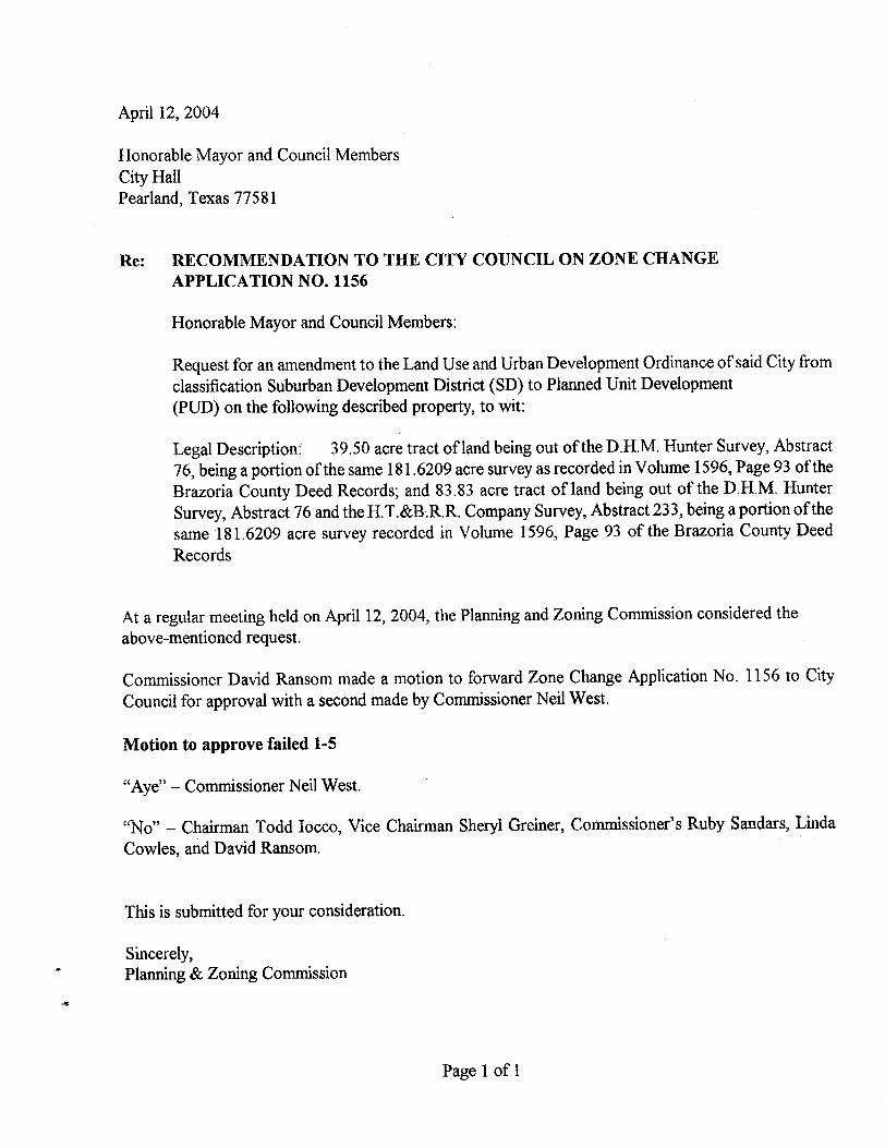
April 12, 2004
Honorable Mayor and Council Members
City HallPearland, Texas 77581
Re: RECOMMENDATION TO THE CITY COUNCIL ON ZONE CHANGE
APPLICATION NO. 1156
Honorable Mayor and Council Members:
Request for an amendment to the Land Use and Urban Development Ordinance of said City fromclassification Suburban Development District (SD) to Planned Unit Development
PUD) on the following described property, to wit:
Legal Description: 39. 50 acre tract of land being out ofthe D.H.M. Hunter Survey, Abstract76, being a portion ofthe same 181. 6209 acre survey as recorded in Volume 1596, Page 93 oftheBrazoria County Deed Records; and 83. 83 acre tract of land being out of the D.H.M. HunterSurvey, Abstract 76 and the H.T. &R.R.R. Company Survey, Abstract 233, being a portion ofthesame 181. 6209 acre survey recorded in Volume 1596, Page 93 of the Brazoria County DeedRecords
At a regular meeting held on April 12, 2004, the Planning and Zoning Commission considered theabove- mentioned request.
Commissioner David Ransom made a motion to forward Zone Change Application No. 1156 to CityCouncil for approval with a second made by Commissioner Neil West.
Motion to approve failed 1 -5
Aye" — Commissioner Neil West.
No" — Chairman Todd Iocco, Vice Chairman Sheryl Greiner, Commissioner' s Ruby Sandars, LindaCowles, and David Ransom.
This is submitted for your consideration.
Sincerely, Planning & Zoning Commission
Page 1 of 1
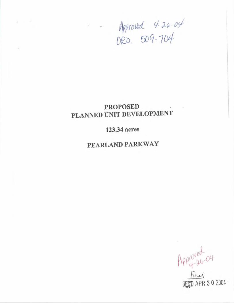
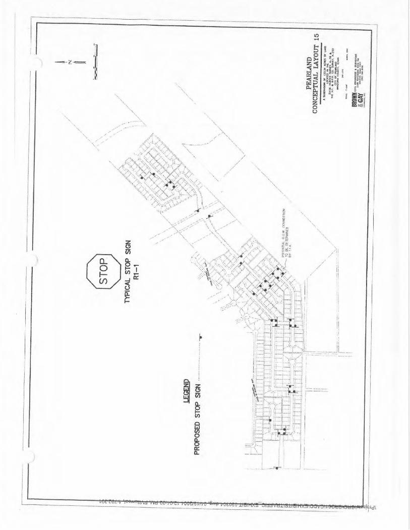
op- 1) 5DI -04
PROPOSED
PLANNED UNIT DEVELOPMENT
123.34 acres
PEARLAND PARKWAY
QD APR 302004
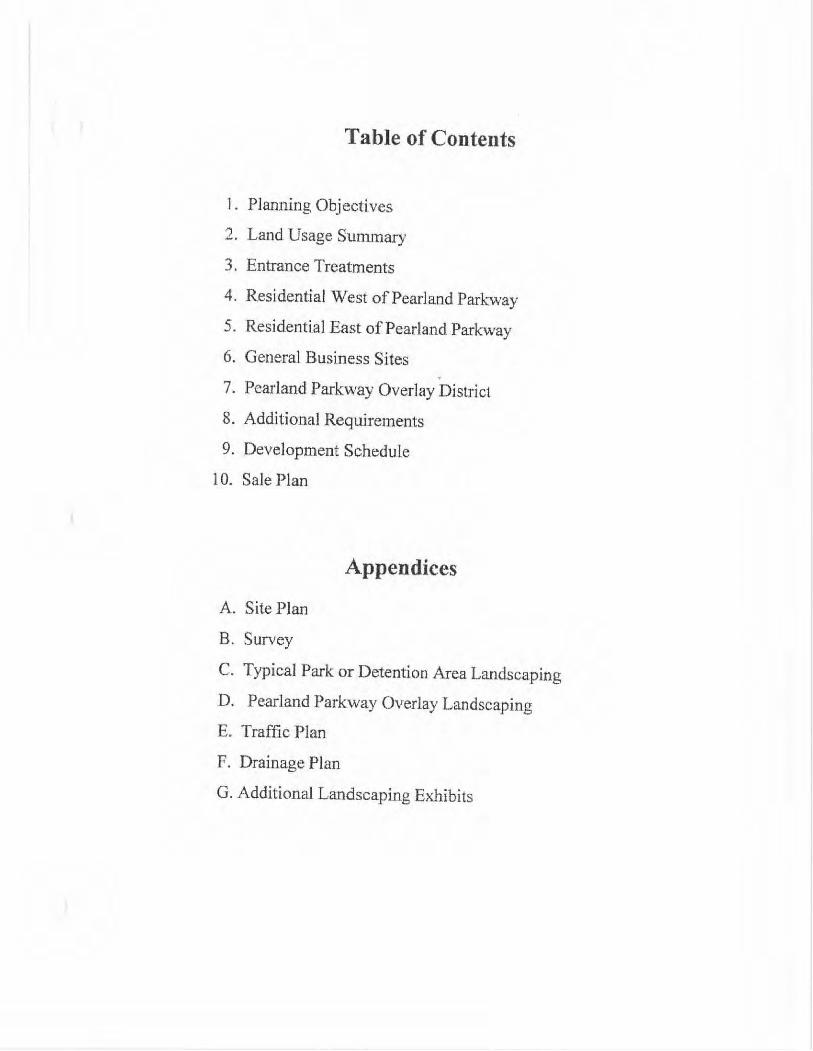
Table of Contents
I. Planning Objectives
2. Land Usage Summary
3. Entrance Treatments
4. Residential West of Pearland Parkway
5. Residential East of Pearland Parkway6. General Business Sites
7. Pearland Parkway Overlay District8. Additional Requirements
9. Development Schedule
10. Sale Plan
Appendices
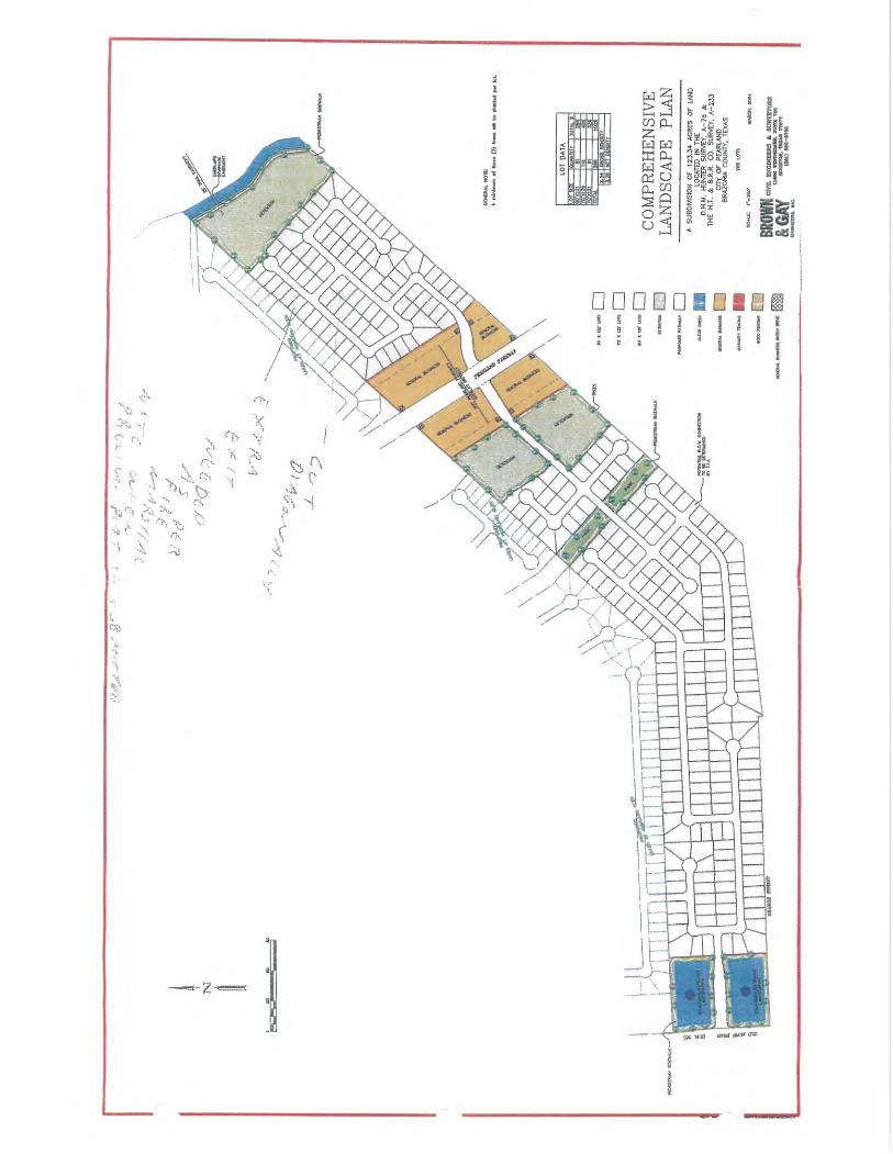
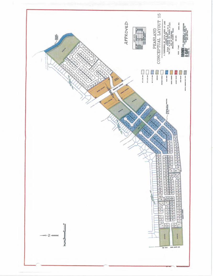
A. Site Plan
B. Survey
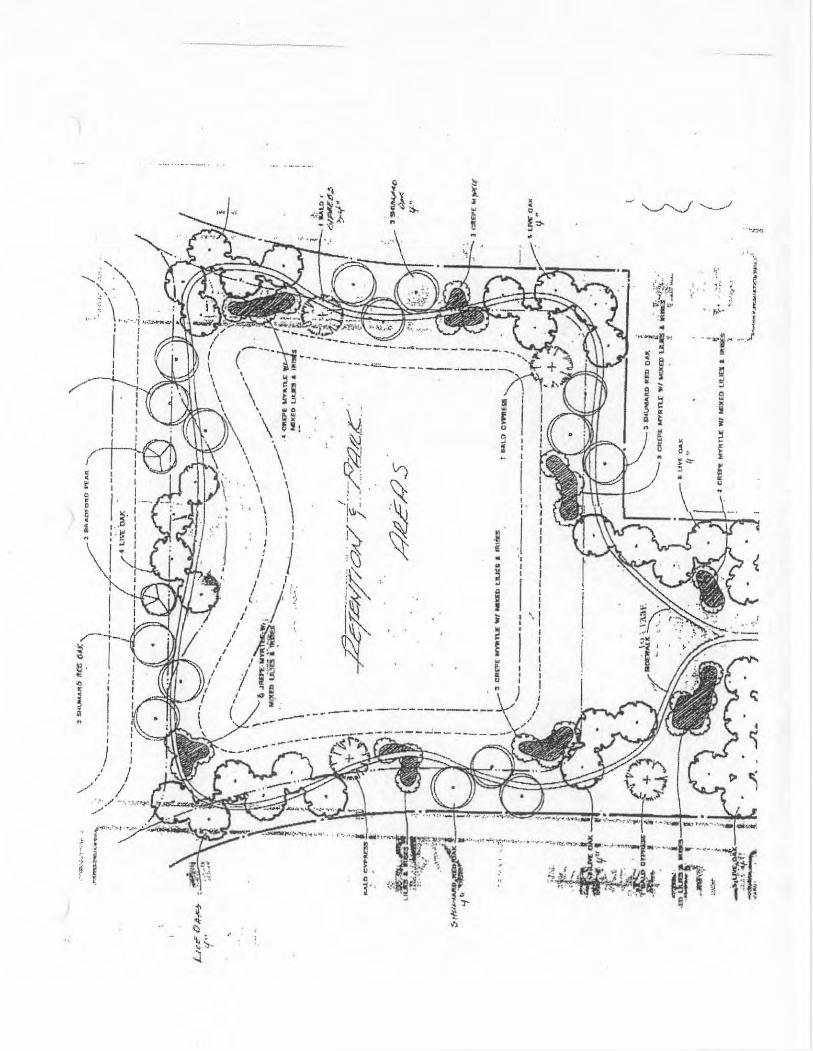
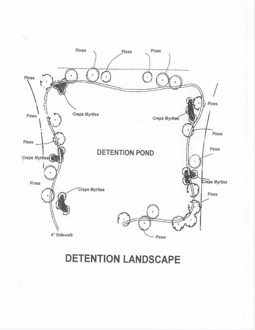
C. Typical Park or Detention Area Landscaping
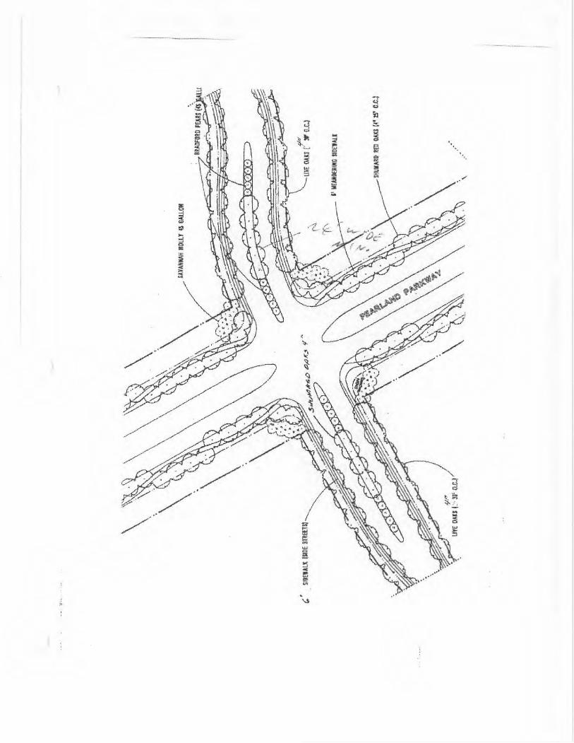
D. Pearland Parkway Overlay LandscapingE. Traffic Plan
F. Drainage Plan
G. Additional Landscaping Exhibits
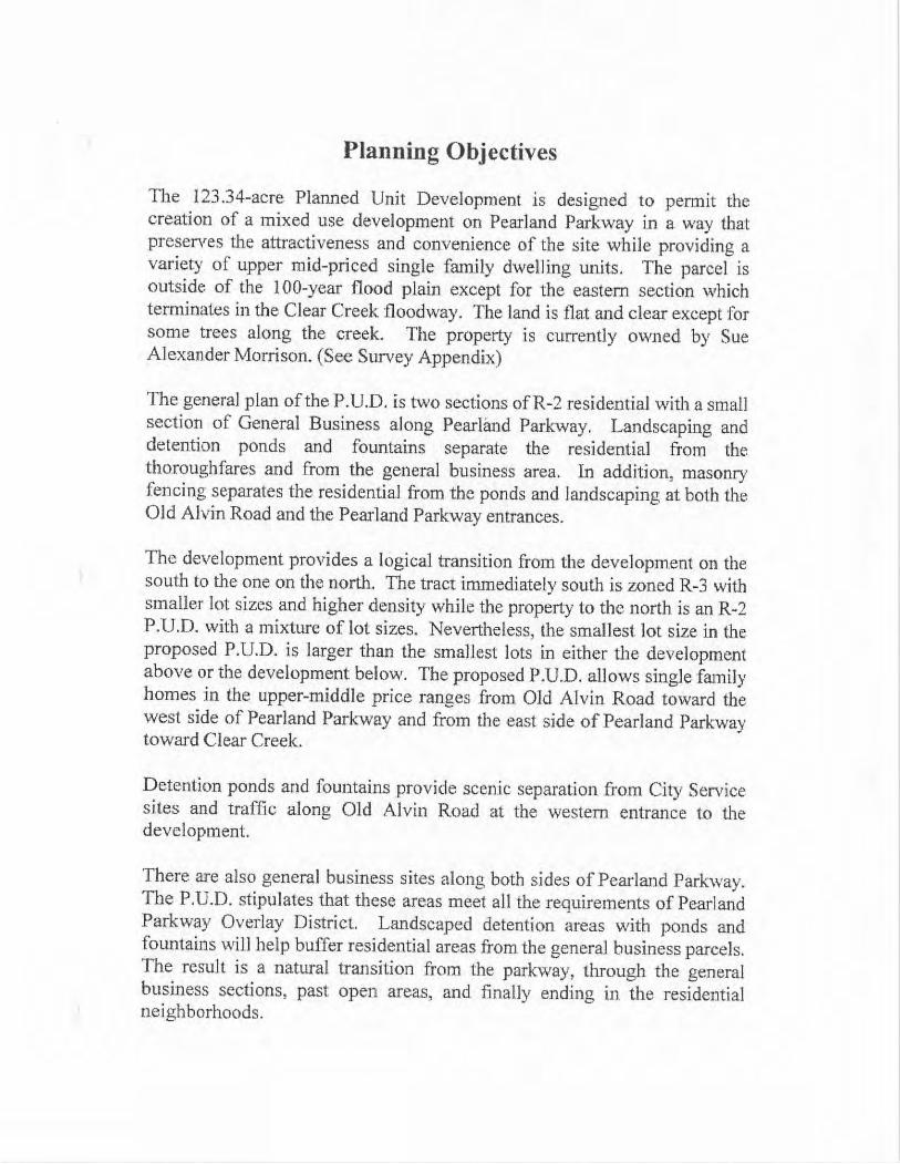
Planning Objectives
The 123.34 -acre Planned Unit Development is designed to permit thecreation of a mixed use development on Pearland Parkway in a way thatpreserves the attractiveness and convenience of the site while providing avariety of upper mid - priced single family dwelling units. The parcel is
outside of the 100 -year flood plain except for the eastern section whichterminates in the Clear Creek floodway. The land is flat and clear except forsome trees along the creek. The property is currently owned by SueAlexander Morrison. (See Survey Appendix)
The general plan of the P.U,D. is two sections of R -2 residential with a smallsection of General Business along Pearland Parkway, Landscaping anddetention ponds and fountains separate the residential from thethoroughfares and from the general business area. In addition, masonryfencing separates the residential from the ponds and landscaping at both theOld Alvin Road and the Pearland Parkway entrances.
The development provides a logical transition from the development on thesouth to the one on the north. The tract immediately south is zoned R -3 withsmaller lot sizes and higher density while the property to the north is an R -2P.U.D. with a mixture of lot sizes. Nevertheless, the smallest lot size in theproposed P.U.D. is larger than the smallest lots in either the developmentabove or the development below. The proposed P.U.D. allows single familyhomes in the upper - middle price ranges from Old Alvin Road toward thewest side of Pearland Parkway and from the east side of Pearland Parkwaytoward Clear Creek.
Detention ponds and fountains provide scenic separation from City Servicesites and traffic along Old Alvin Road at the western entrance to thedevelopment.
There are also general business sites along both sides of Pearland Parkway, The P.U.D. stipulates that these areas meet all the requirements of PearlandParkway Overlay District. Landscaped detention areas with ponds andfountains will help buffer residential areas from the general business parcels. The result is a natural transition from the parkway, through the generalbusiness sections, past open areas, and finally ending in the residentialneighborhoods.
Park lands are carefully situated to compliment the land usage in adjacentdevelopments. Several fault lines terminate in the development to the north, dictating park locations in that development. Parklands in the proposedP. U.D. are located in alignment with the parks to the north, avoidingproblems with any undetected extensions of the fault lines and providing alogical connection of the open areas.
A 8' wide pedestrian pathway corridor & concrete jogging trail will belocated to connect with the trail to the north and south of the developmentand maintained by the Owners Association. Any existing trees and othervegetation along the creek will be left in place. Parks and open areas will belandscaped with trees, shrubs, lawns, and benches,
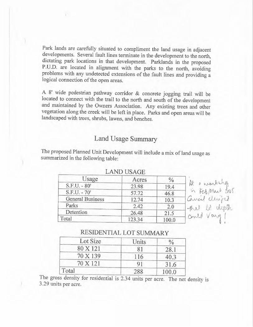
Land Usage Summary
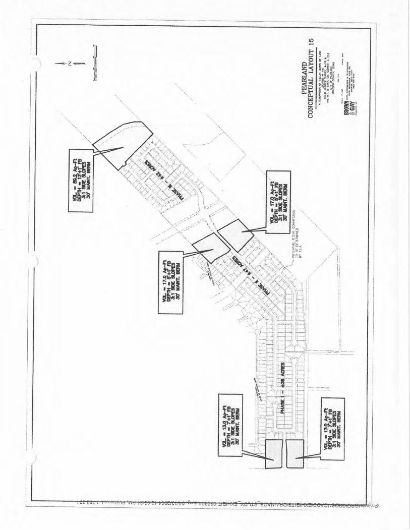
The proposed Planned Unit Development will include a mix of land usage assummarized in the following table:
LAND i lS A GF
Usage AcresS. F.U. - 80' 23.98 19.4S. F.U. - 70' 57.72 46. 8General Business 12. 74 10. 3Parks 2.42 2.0Detention 26. 48 21. 5
Total 1. 23. 34 100.0
RESIDENTIAL LOT SUMMARYLot Size Units
80 X 121 81 28. 170 X 139 116 40.370 X 121 91 31. 6
Total 288 100. 0
The gross density for residential is 2. 34 units per acre. 3. 29 units per acre.
The net density is
Entrance Treatments
Detention Ponds will be masked as a beautiful water feature to combineaesthetics and functionality. The ponds shall be surrounded by landscapingas shown in the Typical Park or Detention Area Landscaping Appendix. These features separate the residential areas from the thoroughfares andfrom general business areas. A masonry wall and appropriate landscapingshall separate and demarcate the residential areas. This treatment providesadditional sound buffering and a pleasant visual transition from busythoroughfares and general business areas.
Residential West of Pearland Park -way
The residential section west of Pearland Parkway shall consist of detached, single family dwelling units and appropriate open park land. All residentialsites in the P. U.D. west of Pearland Parkway shall conform to therequirements for R -2 Residential Zoning. The entrance from Old AlvinRoad shall include highlighted water features and landscaping.
No builder shall place the same home elevation in any five consecutive lotson the same side of the street or on any of the lots on the opposite side ofthestreet from the five consecutive lots. This restriction, more stringent than formost existing Pearland subdivisions, will promote a more interestingstreetscape and a more pleasing sense of diversity. Lot setback lines mayvary from 20' to 30' to promote variety. Each lot shall have a minimum ofthree trees.
Masonry Fences shall be built between the residential area and the waterfeature/ landscaped area facing Old Alvin Road and the area facing PearlandParkway. Ponds shall have a lighted fountain.
Each common open space or detention pond area shall be appropriatelygraded, turfed, surfaced or otherwise landscaped and provided with suitabledrainage facilities. (See Open Space Landscape Example)
For any land or facilities to be used in common by residents of thedevelopment, there shall be provisions made for the establishment of aproperty owners association to manage and maintain such common facilities.
Residential East of Pearland Parkway
The residential section east of Pearland Parkway shall consist of detached, single family dwelling units. All residential sites in the P.U.D. east of
Pearland Parkway shall conform to the requirements for R -2 ResidentialZoning.
No builder shall place the same home elevation in any five consecutive lotson the same side of the street or on any of the lots on the opposite side of thestreet from the five consecutive lots. Lot setback lines may vary from 20' to30' to promote variety. Each lot shall have a minimum of three trees.
Masonry Fences shall be built between the residential area and the detentionpondflandscaped area facing Pearland Parkway. Ponds shall have a lightedfountain.
Each common open space or detention pond area shall be appropriatelygraded, turfed, surfaced or otherwise landscaped and provided with suitabledrainage facilities. (See Open Space Landscape Example)
For any land or facilities to be used in common by residents of thedevelopment, there shall be provisions made for the establishment of aproperty owners association to manage and maintain such common facilities.
General Business Sites
The general business sites in the development are located on either side ofPearland Parkway, as shown on the Site Plan. This is consistent with otherdevelopments that have general business sites along Pearland Parkway. TheGB zone shall comply with all requirements of the Pearland ParkwayOverlay District.
Permitted uses shall be the same as those set forth in Table I.H. of the City ofPearland Land Use & Urban Development Ordinance, Revised April 22,
2002 as it pertains to property zoned GB General Business District.
In connection with any permitted use, there shall be allowed the incidentaldisplay of merchandise out of doors subject to the following limitations: All display areas out of doors shall be confined to a pedestrian walkwayimmediately adjacent to the building housing the primary use, shall notextend from such building a distance of more than ten ( 10) feet, and shall belocated wholly under a permanent part of a main business building such as amarquee, provided that adequate pedestrian access is maintained. Adequate
pedestrian access shall be an unobstructed thirty -six (36) inch walkway.
Screening and fencing shall be provided and maintained as set forth inSection 30 of the City of Pearland Land Use & Urban Development
Ordinance ( Pearland Parkway Overlay District). Parking and loading areasshall be subject to the requirements of Section 30 of the City of PearlandLand Use & Urban Development. Ordinance.
All refuse and refuse containers shall be screened from view of all publicstreets, unless permanent fixtures, aesthetically designed for visiblelocations. The general business area shall be buffered from the residentialarea by a masonry wall. All access to general business sites in. the P.U.D.
shall conform to the requirements of the City of Pearland EngineeringDesign Criteria Manual.
Pearland Parkway Overlay District
All property within the Pearland Parkway Overlay District shall comply withall requirements ofthe Overlay District,
Additional Requirements
Except as otherwise provided in this document, each land use and parceldevelopment shall comply with the City of Pearland Zoning Ordinance, Subdivision Ordinance, Building Code and other applicable developmentregulations.
Parklands
There shall be provisions made for the establishment of a property ownersassociation to own, manage and maintain the 2. 42 acres of park land ( SeeSite Plan). The developer shall pay park fees in lieu of dedication of parkland.
Traffic Impact Analysis
Before Preliminary Platt submittal, a Traffic Impact Analysis study shall becompleted. A street connection shall be made to Schleider Dr. ifrecommended by the Traffic Impact Analysis study. ( See Site Plan)
Development Schedule
Development will proceed in four stages, beginning in June, 2004. The firststage will involve the major infrastructure including most streetimprovements, utilities and detention. Homes will be constructed in the nextthree phases, beginning closest to Pearland Parkway and proceeding towardClear Creek to the east and toward Old Alvin Rd. to the west;
Phase I June 04 — Sept. 04
Final Engineering, Entitlements and Approvals, Dirt work, Construction of Boulevard Entrances, Major Street, Utility and Detention.
Phase II Oct. 04 — Aug. 05
Entrance Monumentation, Local Utility Lines, Begin Residential West of Pearland Parkway,
Phase III Sept. 05 — July 06
Begin Residential East of Pearland Parkway. Additional Local Streets and Utility LinesContinue Residential West ofPearland Parkway, Continue Residential East of Pearland Parkway. Begin General Business.
Phase IV Aug. 06 —June 06
Final Residential East of Old Alvin Rd.,
Final Residential East of Pearland Parkway. Final General Business.
Sale Plan
Lots to the west and east ofPearland Parkway will be sold to several majorbuilders whose product offering is compatible with the price / zoningrequirements of the project.
The ,general business tracts along the parkway will be sold beginning inPhase III as demand dictates.
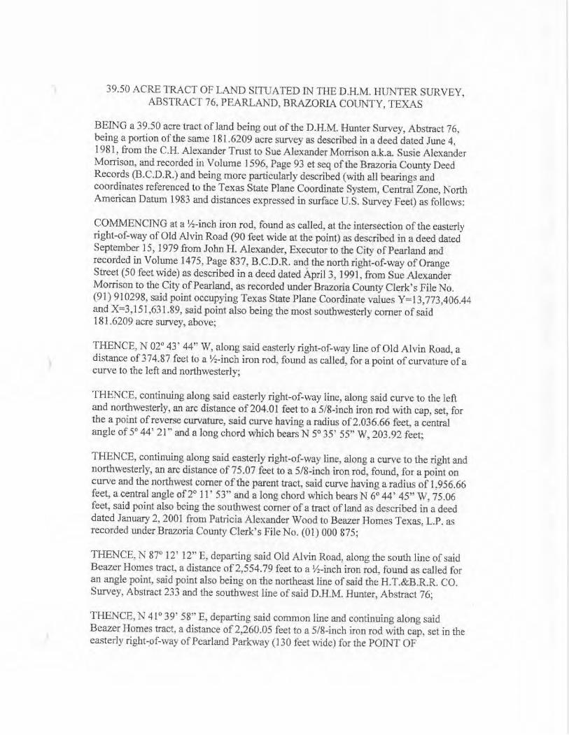
39.50 ACRE TRACT OF LAND SITUATED IN THE D.H.M. HUNTER SURVEY, ABSTRACT 76, PEARLAND, BRAZORIA COUNTY, TEXAS
BEING a 39.50 acre tract of land being out ofthe D.H.M. Hunter Survey, Abstract 76, being a portion of the same 181. 6209 acre survey as described in a deed dated June 4, 1981, from the C.H. Alexander Trust to Sue Alexander Morrison a.k.a. Susie AlexanderMorrison, and recorded in Volume 1596, Page 93 et seq of the Brazoria County DeedRecords ( B.C.D.R.) and being more particularly described (with all bearings andcoordinates referenced to the Texas State Plane Coordinate System, Central Zone, NorthAmerican Datum 1983 and distances expressed in surface U.S. Survey Feet) as follows:
COMMENCING at a i/x - inch iron rod, found as called, at the intersection of the easterlyright -of -way of Old Alvin Road ( 90 feet wide at the point) as described in a deed datedSeptember 15, 1979 from John H. Alexander, Executor to the City ofPearland andrecorded in Volume 1475, Page 837, B.C.D.R. and the north right -of -way of OrangeStreet (50 feet wide) as described in a deed dated Apri13, 1991, from Sue AlexanderMorrison to the City ofPearland, as recorded under Brazoria County Clerk' s File No. 91) 910298, said point occupying Texas State Plane Coordinate values Y= 13, 773,406.44
and X= 3, 151, 631. 89, said point also being the most southwesterly corner ofsaid181. 6209 acre survey, above;
THENCE, N 02° 43' 44" W, along said easterly right -of -way line of Old Alvin Road, adistance of374.87 feet to a / Z - inch iron rod, found as called, for a. point of curvature of a. curve to the left and northwesterly;
THENCE, continuing along said easterly right -of -way line, along said curve to the leftand northwesterly, an are distance of 204.01 feet to a 5/ 8 -inch iron rod with cap, set, forthe a point ofreverse curvature, said curve having a radius of2.036.66 feet, a centralangle of 51 44' 21" and a long chord which bears N 5° 35' 55" W, 203. 92 feet;
THENCE, continuing along said easterly right-of-way line, along a curve to the right andnorthwesterly, an arc distance of 75.07 feet to a 5/ 8 -inch iron rod, found, for a point oncurve and the northwest corner of the parent tract, said curve having a radius of 1, 956.66feet, a central angle of 2° 11' 53" and a long chord which bears N 6° 44' 45" W, 75.06feet, said point also being the southwest comer of a tract of land as described in a deeddated January 2, 2001 from Patricia Alexander Wood to Beazer Homes Texas. L.P. asrecorded under Brazoria County Clerk' s File No. (01) 000 875;
THENCE, N 870 12' 12" E, departing said Old Alvin Road, along the south line of saidBeazer Homes tract, a distance of 2,554. 79 feet to a %T -incb iron rod, found as called foran angle point, said point also being on the northeast line of said the H.T. &B.R.R. CO. Survey, Abstract 233 and the southwest line of said D.H.M. Hunter, Abstract 76;
THENCE, N 41° 39' 58" E, departing said common line and continuing along saidBeazer Homes tract, a distance of 2,260.05 feet to a 5/ 8 -inch iron rod with cap, set in theeasterly right -of- -way ofPearland Parkway ( 1. 30 feet wide) for the POINT OF
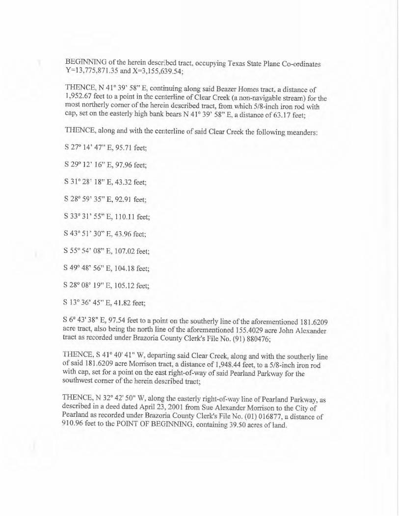
BEGINNING of the herein described tract, occupying Texas State Plane Co- ordinatesY= 13, 775, 871. 35 and X= 3, 155, 639.54;
THENCE, N 41- 39' 58" E, continuing along said Beazer Homes tract, a distance of1, 952.67 feet to a point in the centerline ofClear Creek ( a non - navigable stream) for themost northerly corner of the herein described tract, from which 5/8 -inch iron rod withcap, set on the easterly high bank bears N 410 39' 58" E, a distance of 63. 17 feet;
THENCE, along and with the centerline of said Clear Creels the following meanders:
S 27° 14' 47" E, 95. 7I feet;
S 29° 12' 16" E, 97.96 feet;
S 31- 28' 18" E, 43. 32 feet;
S 28° 59' 35" E, 92. 91 feet;
S 330 31' 55" E, 110. 1. 1 feet;
S 430 51' 30" E, 43. 96 feet;
S 55° 54' 08" E, 107.02 feet;
S 490 48' 56" E, 104. 18 feet;
S 28° 08' 19" E, 105. 12 feet;
S 1. 3° 36' 45" E, 41. 82 feet;
S 6° 43' 38" E, 97.54 feet to a point on the southerly line ofthe aforementioned 181. 6209acre tract, also being the north Pane of the aforementioned 155. 4029 acre John Alexandertract as recorded under Brazoria County Clerk's File No. (91) 880476;
THENCE, S 410 40' 41 " W, departing said Clear Creek, along and with the southerly lineof said 181. 6209 acre Morrison tract, a distance of 1, 948. 44 feet, to a 5/ 8 -inch iron rodwith cap, set for a point on the east right -of -way of said Pearland Parkway for thesouthwest corner of the herein described tract;
THENCE, N 320 42' 50" W, along the easterly right -of -way line of Pearland Parkway, asdescribed in a deed dated April 23, 2001 from Sue Alexander Morrison to the City ofPearland as recorded under Brazoria County Clerk's File No. (01) 016877, a distance of910,96 feet to the POINT OF BEGINNING, containing 39.50 acres of land.
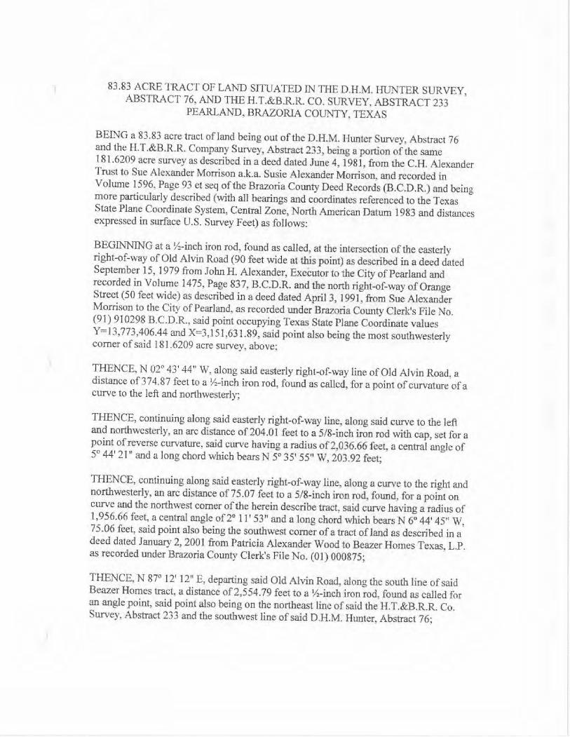
83. 83 ACRE TRACT OF LAND SITUATED IN THE D.H.M. HUNTER SURVEY, ABSTRACT 76, AND THE H.T. &B.R.R CO. SURVEY, ABSTRACT 233
PEARLAND, BRAZORIA COUNTY, TEXAS
BEING a 83. 83 acre tract of land being out of the D.H.M. Hunter Survey, Abstract 76and the H.T. &BAR. Company Survey, Abstract 233, being a portion of the same181. 6209 acre survey as described in a deed dated June 4, 1981, from the C.H. AlexanderTrust to Sue Alexander Morrison a.k.a. Susie Alexander Morrison, and recorded inVolume 1596, Page 93 et seq of the Brazoria County Deed Records (B.C.D.R) and beingmore particularly described (with all bearings and coordinates referenced to the TexasState Plane Coordinate System, Central Zone, North American Datum 1983 and distancesexpressed in surface U.S. Survey Feet) as follows:
BEGINNING at a V -inch iron rod, found as called, at the intersection of the easterlyright -of -way of Old Alvin Road ( 90 feet wide at this point) as described in a deed datedSeptember 15, 1979 from John H. Alexander, Executor to the City of Pearland andrecorded in Volume 1475, Page 837, B.C.D.R and the north right -of -way of OrangeStreet (50 feet wide) as described in a deed dated April 3, 1991, from Sue AlexanderMorrison to the City ofPearland, as recorded under Brazoria County Clerk's File No.
91) 910298 B.C. D.R., said point occupying Texas State Plane Coordinate valuesY= 13, 773,406.44 and X= 3, 151, 631. 89, said point also being the most southwesterlycorner of said 181. 6209 acre survey, above,
THENCE, N 02° 43' 44" W, along said easterly right -of -way line of Old Alvin Road, adistance of 374. 87 feet to a 1s -inch iron rod, found as called, for a point of curvature of acurve to the left and northwesterly;
THENCE, continuing along said easterly right -of -way line, along said curve to the leftand northwesterly, an are distance of204.01 feet to a 5/ 8 -inch iron rod with cap, set for apoint of reverse curvature, said curve having a radius of 2,036.66 feet, a central angle of5° 44' 21 " and a long chord which bears N 5° 35' 55" W, 203.92 feet;
THENCE, continuing along said easterly right -of -way line, along a curve to the right andnorthwesterly, an arc distance of 75. 07 feet to a 5 /8 -ineb iron rod, found, for a point oncurve and the northwest comer ofthe herein describe tract, said curve having a radius of1, 956.66 feet, a central angle of 21 1 F53 " and a long chord which bears N 6° 44, 45" W, 75. 06 feet, said point also being the southwest corner of a tract of land as described in a. deed dated January 2, 2001 from Patricia Alexander Wood to Beazer Homes Texas, L.P. as recorded under Brazoria County Clerk' s File No. (01) 000875;
THENCE, N 87° 12' 12" E, departing said Old Alvin Road, along the south line of saidBeazer Homes tract, a distance of2, 554. 79 feet to a' / ranch iron rod, found as called foran angle point, said point also being on the northeast line of said the H.T. &B.R.R. Co. Survey, Abstract 233 and the southwest line of said D.H.M. Hunter, Abstract 76;
THENCE, N 410 39' 58" E, departing said common line and continuing along said BeazerHomes tract, a distance of2, 125.06 feet to a 5/ 8 -inch iron rod with cap, set in thewesterly right -of -way of Pearland Parkway ( 130 feet wide) and being the northeast cornerofthe herein described tract;
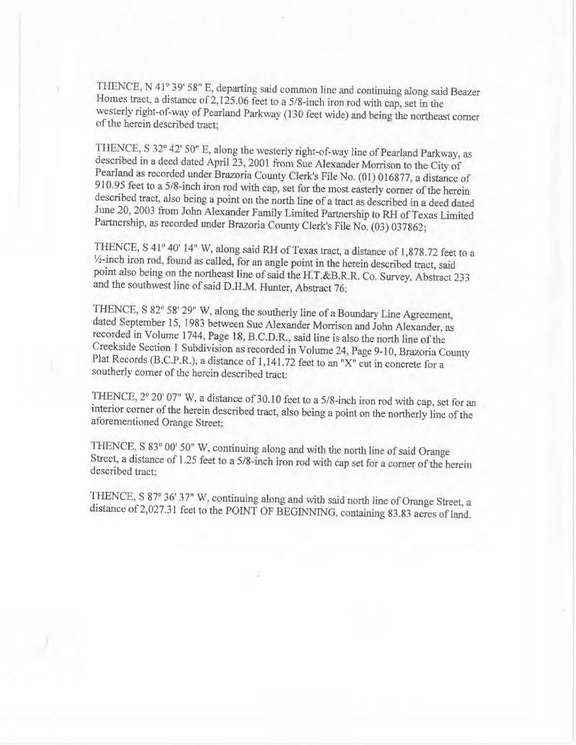
THENCE, S 320 42' 50" E, along the westerly right -of -way line of Pearland Parkway, asdescribed in a deed dated April 23, 2001 from Sue Alexander Morrison to the City ofPcarland as recorded under Brazoria County Clerk's File No. (01) 016877, a distance of910.95 feet to a 5/8 -inch iron rod with cap, set for the most easterly corner of the hereindescribed tract, also being a point on the north line of a tract as described in a deed datedJune 20, 2003 from John Alexander Family Limited Partnership to RH ofTexas LimitedPartnership, as recorded under Brazoria County Clerk's File No. (03) 037862;
THENCE, S 410 40' 14" W, along said RH ofTexas tract, a distance of 1, 878. 72 feet to a2 -inch iron rod, found as called, for an angle point in the herein described tract, said
point also being on the northeast tine of said the H.T. &BRK Co. Survey, Abstract 233and the southwest line of said D.H.M. Hunter, Abstract 76;
THENCE, S 820 58' 29" W, along the southerly line of a Boundary Line Agreement, dated September 15, 1983 between Sue Alexander Morrison and John Alexander, asrecorded in Volume 1744, Page 18, B.C.D.R., said line is also the north line of theCreekside Section l Subdivision as recorded in Volume 24, Page 9 -10, Brazoria CountyPlat Records ( B. C.P.R.), a distance of 1, 141. 72 feet to an "X" cut in concrete for asoutherly comer of the herein described tract:
THENCE, 20 20' 07" W, a distance of30. 10 feet to a 5/ 8 -inch iron rod with cap, set for aninterior comer of the herein described tract, also being a point on the northerly line of theaforementioned Orange Street;
THENCE, S 83° 00' 50" W, continuing along and with the north line of said OrangeStreet, a distance of 1. 25 feet to a 5/ 8 -inch iron rod with cap set for a corner of the hereindescribed tract;
THENCE, S 97 36 37" W, continuing along and with said north line ofOrange Street, adistance of 2, 027.31 feet to the POINT OF BEGINNING, containing 83. 83 acres of land.
I
LO
c.
pQ
t
3
L
tei
Pi
a ' i
9 1.
i
n {
aS 3
x ;
i
Q
V
paey
ts
W
m
y {
4
e; Yl.
C }}
yWZ
sf s
1
ts
W
m
y {
4
OR
C
a
v
f7
Pines
t Pines `
Pines
Crepe
Pines
Pines
v vF. myntaa
4" Sidewalk
Pines
DETENTION POND
Pines
DETENTION LANDSCAPE
r Pines
Pines
Pines
Myrtles
Pines
W
QU
N N y NN d
X Y
aA C O T Ofti
D _ Qd U a Qd
J @
l —
f' N N
CLl0 I 41.
G CCL 0
ail
T d d
arr LO \ (
W dUn ( 0 o
m I
i a G LL NC
6]
iJ
i I1.
R a. O
CL
N / i O I 9r '
ca f.jv ' i dny (( a O U I I I C
1 • +
i / ter^.• •
dN ^ to
Lnyy CL N
s / a d d ca d
O U d to
d `- a N d'' q
O
T E > m U >
a Z qcoo
n. = o
momO 0)..c -0L- ' C ( v L
L) a
Ogg
a CL fQ
F-
L
O
fn O © co o
i
J
0n
NR
u
zki
T. J
v'
ajq
q m
3 I
s
m
a
M'
cm
zwas
axw
a
WCL
W g1
i
J
0n
NR
u
zki
T. J
v'
ajq
q m
3 I
s
m
a
M'
cm
zwas
axw
a
CD
ED
L
dw
r
L
U
O
Uw
L
a
ca
Ud
w
UZwLL
wZ0
a
i`
t-- a
w
rUv f
r
X
X
CD
O
dU OON O
OU c
a
Y S EUO C r
i X
Q o
w
UZwLL
wZ0
a
i`
t-- a
w
rUv f
Typical Precast Fence Examples:
Brick Style
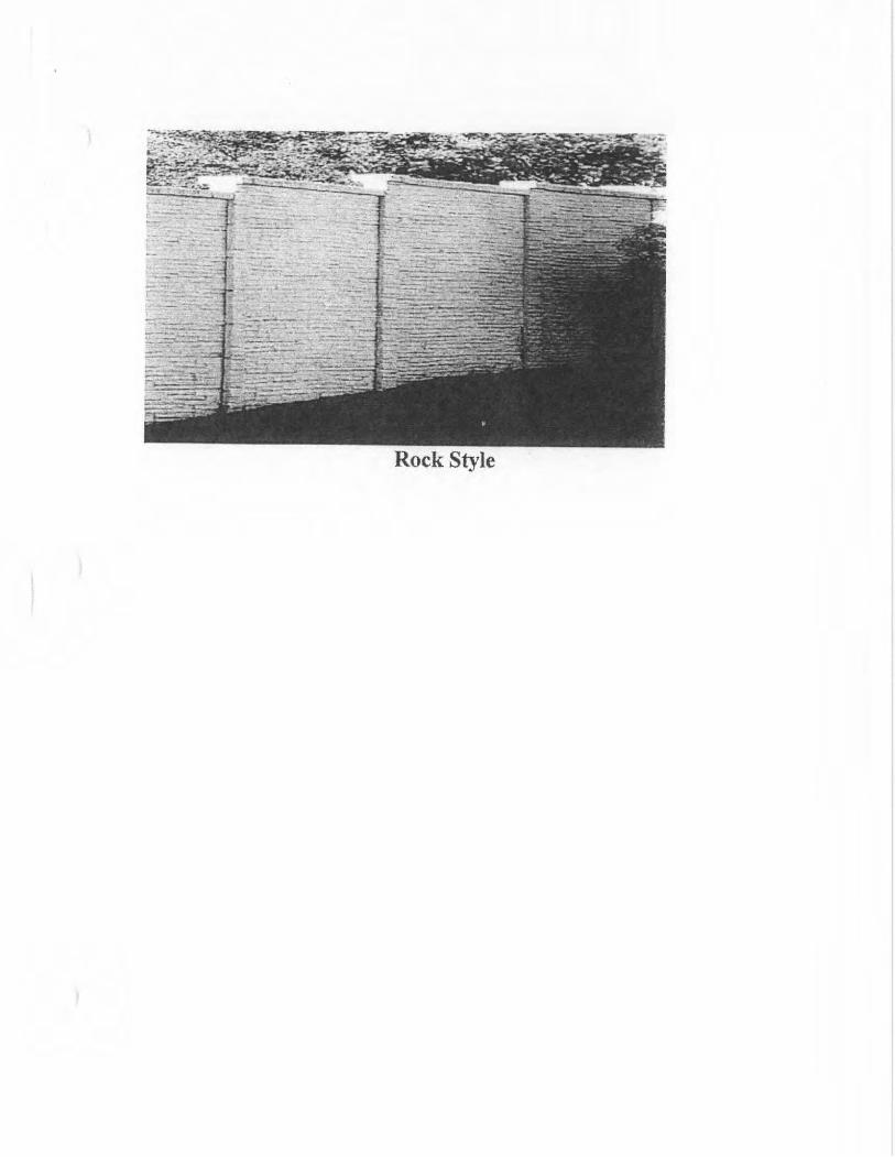
Rock Style
2a ƒ:
q§
x\
S
GE000
F
1a W Q b<
ie g
i oii
1
9