Embed Size (px)
Citation preview
W H I T E P AP E R
E S R I : E x t e n d i n g G I S t o E n t e r p r i s e Ap p l i c a t i o n s Sponsored by: ESRI
David Sonnen(ISSI) Henry D. Morris February 2005
E X E C U T I V E S U M M A R Y
ESRI has led the GIS industry in revenue and growth for years. But, geospatial technology is beginning to reach beyond traditional GIS. Today, businesses are migrating location-specific capabilities into their information systems. Also, information systems are evolving from distributed client-server architectures to more networked, service-oriented approaches. Geospatial technology must evolve along the same lines.
ESRI intends to lead these new geospatial markets just as it has led GIS. To accomplish its ambitious goal, ESRI embarked on these three broad strategies:
! Expand existing GIS implementations into enterprisewide solutions.
! Leverage ArcGIS 9's new federated capabilities to geospatially enable enterprise business systems (i.e., ERP, CRM, logistics, BI, operational analytics, etc).
! Aggressively partner with major enterprise vendors and developers to add geospatial capabilities to their enterprise solutions. ESRI's enterprise partners include established players like SAP, IBM, PeopleSoft, Information Builders, and SAS Institute.
ESRI will launch its new strategies from a time-tested and proven business approach: ESRI allows users to manage their geospatial workflows and data independently from underlying IT technology � hardware, database, and integration platforms.
The technical foundation for ESRI's strategies is ArcGIS 9. This major revision of ESRI's product line includes an enterprise-grade GIS server, embeddable component libraries, and a developer's framework. ESRI sees service-oriented architecture (SOA) as the appropriate framework for maintaining its independence from underlying IT technology, while maintaining working compliance with IT standards and systems.
ESRI's business and technologies have worked. ESRI builds from a strong, established position in GIS. In 2004. ESRI grew at a healthy 16%, generating about $500 million in software and service sales. ESRI is the dominant vendor in established GIS markets. It holds between 80�90% of government and regulated sector markets and is the de facto GIS standard among a number of agencies.
Glo
bal H
eadq
uarte
rs: 5
Spe
en S
treet
Fra
min
gham
, MA
0170
1 U
SA
P.
508.
872.
8200
F
.508
.935
.401
5
ww
w.id
c.co
m
2 #05C4372 ©2005 IDC
ESRI is also seeing growth in enterprise markets. For example, Sears uses ArcGIS in systems that dispatch and manage Sear's 25,000-vehicle service fleet. Sears is expanding its ESRI system to include logistics and inventory management applications.
I N T H I S W H I T E P AP E R
In this white paper, IDC describes emerging geospatial markets and maps ESRI's products and capabilities against those markets. Specifically in the Situation Overview section, we detail the structure and drivers that will shape geospatial markets. In the section ESRI's Products and Strategies, we describe ESRI's ArcGIS 9 technology and outline ESRI's strategy for expanding its new technology into GIS and broad enterprise markets. In the Challenges and Opportunities section we map ESRI's strategies and capabilities against customer groups and competition. We conclude with a case study that illustrates ESRI's strategy and new technologies.
In preparing this paper, we interviewed a number of ESRI users and partners in depth. We cite our interview results as appropriate.
S I T U AT I O N O V E R V I E W
The key point here is that the history of ESRI's technology tracks closely with major IT trends. ArcGIS 9 is ESRI's current step in the evolution of its technology.
In 1981, when ESRI introduced ArcInfo, minicomputers were the dominant platform. Early ArcInfo systems ran on dedicated Primes, Data Generals, and DECs. In these single-purpose systems, software was "optimized" for the hardware, meaning that there were software dependencies for each hardware platform. By 1989, Unix workstations from companies like Sun, HP, Apollo, and IBM supplanted minicomputers for scientific computing, and ESRI ported ArcInfo to the many flavors of Unix. At this stage, there were still some hardware dependencies, and vendors still used proprietary data formats to protect their markets.
By the mid-90s, the concepts of "corporate database," "client-server," and "open systems" were driving information technology. The idea of Web services was just beginning emerge. Considering these new technology drivers, ESRI decided to completely redesign its technology. Beginning in 1996, ESRI focused on making its technology work with database management systems and on modular components that could be used in any computing environment. ESRI also implemented open systems and reduced proprietary barriers to free data exchange.
ESRI's more open approach has proven to be a good call. It plays directly into the current demand for location-specific capabilities to support business processes.
The reason for this increasing demand is simple: location is a fundamental, real-world organizing principle. As information systems evolve to accurately reflect real-world processes, location has to be accurately represented. In the near future, location will be deeply and invisibly integrated into all aspects of information systems.
©2005 IDC #05C4372 3
Increasingly, the IT environment consists of loosely coupled components that work together within standards-based integration platforms. In this environment, users will mix and match software freely to support their ever-changing business requirements. They will use and dispose of software as their needs change and as cheaper, more effective solutions become available. ESRI's choice of SOA and component-based development approaches fits logically into these user requirements.
G e o s p a t i a l M a r k e t s
Today, geospatial technologies are increasingly shaped by a broad IT integration imperative � the driving need to orchestrate information to support business processes. This means that geospatial capabilities will have to be tightly integrated into applications as those capabilities are needed.
Going forward, information will be managed and accessed within service-oriented architectures and standards-based integration platforms. This standards-based environment will allow information systems to freely exchange data and business logic to create information � information that supports dynamic business processes in real time.
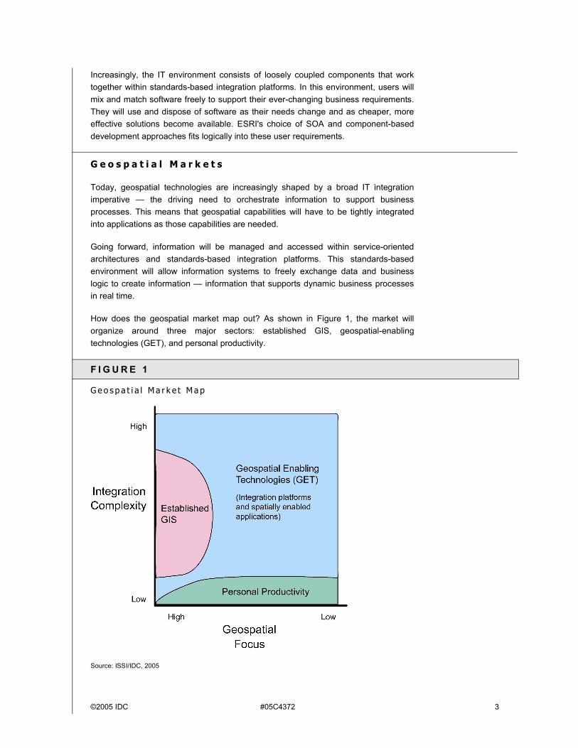
How does the geospatial market map out? As shown in Figure 1, the market will organize around three major sectors: established GIS, geospatial-enabling technologies (GET), and personal productivity.
F I G U R E 1
G e o s p a t i a l M a r k e t M a p
Source: ISSI/IDC, 2005
4 #05C4372 ©2005 IDC
Established GIS
The established GIS sector is relatively mature with a knowledgeable and dedicated user community. This community represents a tight-knit group of talented and passionate GIS technologists, a dynamic vendor community, a variety of user groups, meaningful standards activities, and well-established industry magazines and events.
Established GIS centers on an information systems approach to storing, managing, and applying data that represents geographic features. GIS includes a formal data model.
Geocentric workflows shape current GIS functionality and systems. Generally, GIS systems are tight, vertically integrated packages that have been optimized to support workflows like land records management, management of natural resources, utility asset management, and many applications within homeland security/defense.
Going forward, GIS systems will be increasingly shaped by the integration imperative that now drives the rest of IT. This means that many current GIS capabilities will increasingly be integrated within enterprise information systems using service-oriented architectures. ESRI calls these extended systems "enterprise GIS".
ESRI is uniquely positioned to expand enterprise GIS. It has a dominant share of the current GIS market and has an enthusiastic installed base. Many of ESRI's customers want to extend their GIS capabilities into the rest of their organizations. Consequently, those customers are eager and willing to evangelize ESRI's capabilities and work to spread ESRI technology. As we will discuss later, ESRI's ArcGIS 9 is well-suited for Enterprise GIS.
Geospatial-Enabling Technologies
Geospatial-enabling technologies (GET) are necessarily less well defined. GET is about adding geospatial data and capabilities to the broad spectrum of information systems. Applications and workflows in the GET space are not primarily geocentric, however geospatial information has value and is sometimes essential. Examples include risk assessment and mitigation, transportation, logistics, defense/homeland security, sales force automation, ERP and CRM � literally any system that represents things on the Earth.
Success in this sector will depend on the ability to deliver simple, seamless, and inexpensive geospatial capabilities to support business processes. What are these geospatial capabilities?
Geospatial technology and data can add unique value to enterprise information in a number of ways. For convenience, IDC groups geospatial capabilities into following six categories:
! Spatial context. Location along with time are fundamental ways that we order our lives. In an information system, location provides a useful context that makes other data more meaningful.
©2005 IDC #05C4372 5
! Quantification/measurement. In information systems, geospatial data and technology add unique spatial concepts like distance and physical relationships between objects (e.g., routing; network analysis proximity measures like nearby, within; or buffers).
! Modeling. Studying geographic patterns and processes (e.g., look for trends, explain geographic variations, predict the occurrence/values of one variable given data on another).
! Geographic analysis. Adjacency, containment and proximity.
! Reference. Reference data is used to group, cluster, or categorize other data found in a database or for relating data in a database to information beyond the boundaries of the enterprise. One example would be state abbreviation tables or tax district boundary files.
! Visualization. Perhaps the most familiar use of geospatial technology is for visual display of data on maps. The map metaphor also provides a useful visual index into some types of data.
In contrast with the tight vertical integration needed to support GIS workflows, geospatial-enabling technologies must be loosely coupled with an unpredictably broad range of other enterprise applications.
The potential GET user base is orders of magnitude larger than GIS, and consequently has the potential to become a strong revenue producer. Revenue will be realized from a broadened applications market, primarily from incremental sales of spatially enabled software, data, and services.
Personal Productivity
At the simpler end of the market, individuals use geospatial technology for personal productivity. Many capabilities are delivered as targeted Web services like store locators or Web-based mapping. Also, easy-to-use desktop mapping applications will continue to spread among business users. Revenue will be realized from consumer-oriented business models and Web service subscriptions.
E S R I ' S P R O D U C T S AN D S T R AT E G I E S
ESRI expects to participate in future information ecosystems in which each participant brings its unique value to the market and complements the others' capabilities. ESRI is evolving its technology and business models to meet this requirement.
ESRI addresses all potential geospatial markets � GIS, GET, and Personal Productivity. To serve these markets, ESRI has embarked on three broad strategies:
! Expand existing GIS implementations into enterprisewide solutions,
! Leverage ArcGIS 9's new federated capabilities to geospatial-enable enterprise business systems (i.e., ERP, CRM, logistics, etc),
6 #05C4372 ©2005 IDC
! Aggressively partner with major enterprise vendors and developers to add geospatial capabilities to their enterprise solutions.
To help understand ESRI's strategies, we will first look at ESRI's technology, then examine its business models and partnering practices.
E S R I E n t e r p r i s e T e c h n o l o g y : A r c G I S 9
ArcGIS 9 is a comprehensive package of geospatial capabilities that can be used by both GIS professionals and enterprise developers. In the case of GIS-centric applications, as used by professional GIS analysts, ESRI has built a suite of desktop products (ArcView, ArcEditor, ArcInfo) � The mainstay of geographic information workflows in desktop project and workgroup GIS systems.
ESRI has also productized and made available to developers the component libraries used to create its desktop products (ArcGIS Engine). Finally, ESRI has packaged its component libraries as a GIS server (ArcGIS Server) that allows central management of geospatial services to use the same collection of comprehensive, high-end components used in its desktop solutions.
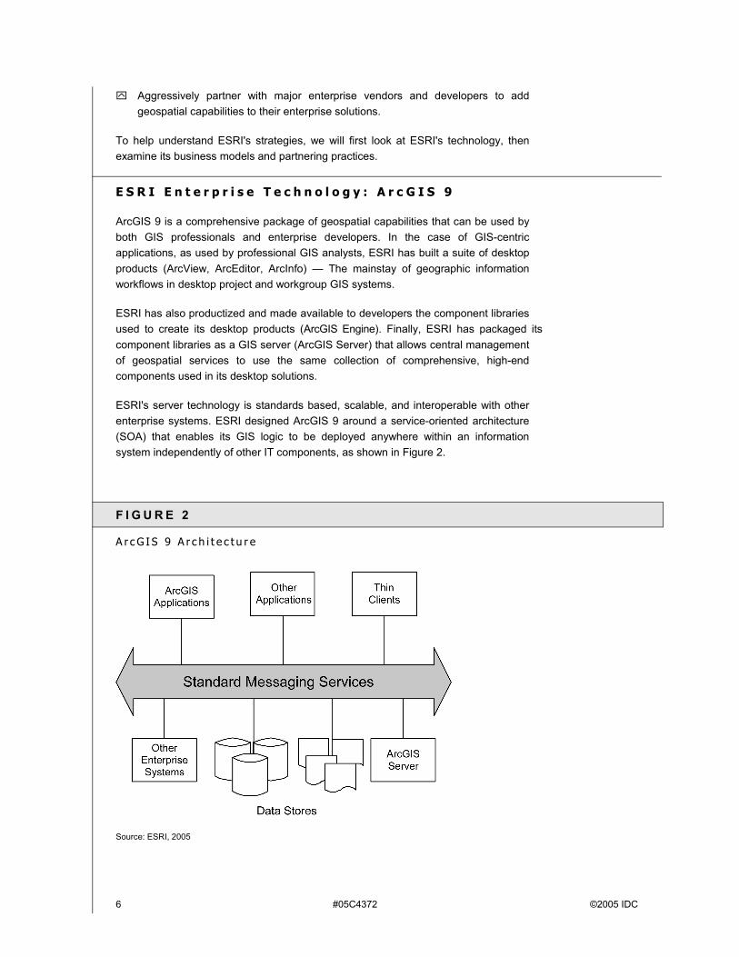
ESRI's server technology is standards based, scalable, and interoperable with other enterprise systems. ESRI designed ArcGIS 9 around a service-oriented architecture (SOA) that enables its GIS logic to be deployed anywhere within an information system independently of other IT components, as shown in Figure 2.
F I G U R E 2
A r c G I S 9 A r c h i t e c t u r e
Source: ESRI, 2005
©2005 IDC #05C4372 7
ArcGIS Desktop
This module will be most familiar to GIS professionals. This is the traditional client-side GIS for compiling, authoring, and using geographic information. In an enterprise setting, ArcGIS will likely be used to create and maintain the user's geospatial datasets and to perform advanced analytical and mapping tasks.
ArcGIS Engine
The engine is a set of embeddable components for incorporating GIS capabilities into other applications. Application vendors may use ArcGIS Engine to extend applications like business intelligence, ERP, SFA, or CRM. ArcGIS Engine consists of two products: a software development kit and a redistributable runtime for Windows, Unix, Linux environments. This is one of ESRI's core products for integrating geospatial capabilities into business applications. ArcGIS Engine targets the developer community that is imbedding geospatial functionality into other applications.
ArcGIS Server
ArcGIS Server is an enterprise-grade GIS application server that provides ESRI's complete GIS capabilities � mapping, geocoding, spatial queries, editing, spatial analysis, tracing, and linear referencing, etc., throughout an organization while maintaining centrally managed spatial databases. The Server includes a shared library of geospatial software objects for building or extending server-side spatially enabled applications and Web-computing frameworks .
ArcGIS Server and its supporting technology systems can be used in both intranet and Internet contexts. It supports multiple platforms (Windows, Unix, and Linux). ArcGIS Server can be integrated into existing distributed, multitier services-oriented architectures using industry-standard programming environments and application server technologies.
Application Servers and Data Management
DBMS and specialist file-based data sources provide the storage and management services for ESRI's GIS applications. ArcGIS 9 has been designed to support data access and integration with platforms like IBM's DB2 and WebSphere, Microsoft.Net, and Oracle's 10g. ESRI's intention is to let its users control and manage spatial capabilities within data management and data access layers independently of database and integration platform technology.
E S R I F e d e r a t e d G I S
Federated information management is about loosely coupled networks of heterogeneous components that function independently of data sources or other applications. ArcGIS 9 is designed to operate within this federated model as well as within current database-centric and client-server architectures.
8 #05C4372 ©2005 IDC
Since ArcGIS 9 components and protocols are all industry standard, it can be called from any other standards-based application. This capability lets ArcGIS 9 components act as first-class citizens within any enterprise information system.
The ArcGIS 9 information management approach is consistent with advanced enterprise IT platforms like IBM DB2/WebSphere, Microsoft.NET, Oracle 10g, and SAP NetWeaver. The characteristics of these advanced platforms include:
! Ad hoc combinations of information maintained in separate data stores
! Information and logic can be distributed across many nodes and in many different architectures
! Complex, dynamic information models
! Large, complex data sets
! Open, standards-based architectures
! Platform-neutral development environments and applications
Developers can use ArcGIS 9 components to create and manage server-based applications that share geographic knowledge within organizations or across the Internet. This means that ArcGIS 9 can serve geospatial information and applications to a web of loosely-coupled, heterogeneous information system nodes, as illustrated in Figure 3.
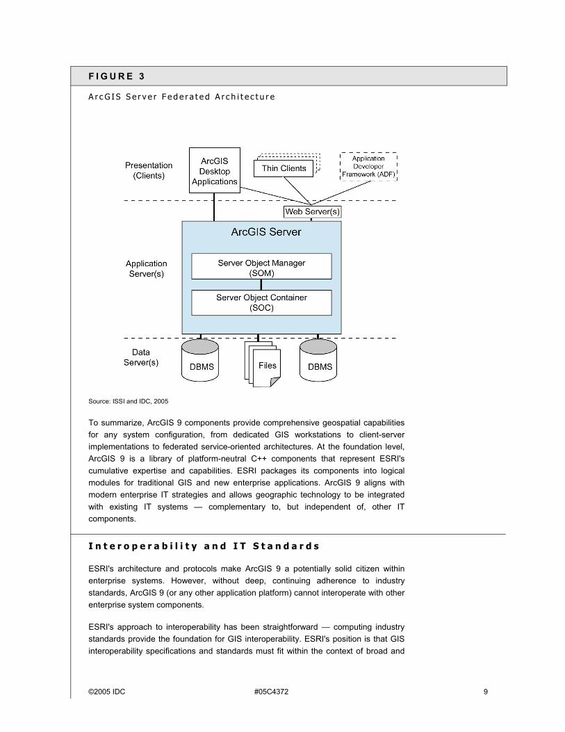
©2005 IDC #05C4372 9
F I G U R E 3
A r c G I S S e r v e r F e d e r a t e d A r c h i t e c t u r e
Source: ISSI and IDC, 2005
To summarize, ArcGIS 9 components provide comprehensive geospatial capabilities for any system configuration, from dedicated GIS workstations to client-server implementations to federated service-oriented architectures. At the foundation level, ArcGIS 9 is a library of platform-neutral C++ components that represent ESRI's cumulative expertise and capabilities. ESRI packages its components into logical modules for traditional GIS and new enterprise applications. ArcGIS 9 aligns with modern enterprise IT strategies and allows geographic technology to be integrated with existing IT systems � complementary to, but independent of, other IT components.
I n t e r o p e r a b i l i t y a n d I T S t a n d a r d s
ESRI's architecture and protocols make ArcGIS 9 a potentially solid citizen within enterprise systems. However, without deep, continuing adherence to industry standards, ArcGIS 9 (or any other application platform) cannot interoperate with other enterprise system components.
ESRI's approach to interoperability has been straightforward � computing industry standards provide the foundation for GIS interoperability. ESRI's position is that GIS interoperability specifications and standards must fit within the context of broad and
10 #05C4372 ©2005 IDC
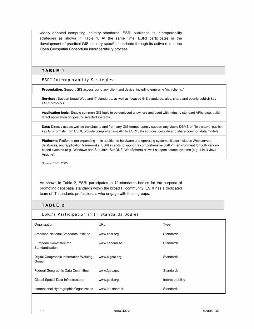
widely adopted computing industry standards. ESRI publishes its interoperability strategies as shown in Table 1. At the same time, ESRI participates in the development of practical GIS industry-specific standards through its active role in the Open Geospatial Consortium interoperability process.
T A B L E 1
E S R I I n t e r o p e r a b i l i t y S t r a t e g i e s
Presentation: Support GIS access using any client and device, including emerging "rich clients."
Services: Support broad Web and IT standards, as well as focused GIS standards; also, share and openly publish key ESRI protocols.
Application logic: Enable common GIS logic to be deployed anywhere and used with industry standard APIs; also, build direct application bridges for selected systems.
Data: Directly use as well as translate to and from any GIS format, openly support any viable DBMS or file system, publish key GIS formats from ESRI, provide comprehensive API to ESRI data sources, compile and share common data models.
Platforms: Platforms are expanding � in addition to hardware and operating systems, it also includes Web servers, databases, and application frameworks. ESRI intends to support a comprehensive platform environment for both vendor-based systems (e.g., Windows and Sun-Java-SunONE, WebSphere) as well as open source systems (e.g., Linux-Java-Apache).
Source: ESRI, 2005
As shown in Table 2, ESRI participates in 12 standards bodies for the purpose of promoting geospatial standards within the broad IT community. ESRI has a dedicated team of IT standards professionals who engage with these groups.
T A B L E 2
E S R I ' s P a r t i c i p a t i o n i n I T S t a n d a r d s B o d i e s
Organization URL Type
American National Standards Institute www.ansi.org Standards
European Committee for Standardization
www.cenorm.be Standards
Digital Geographic Information Working Group
www.digest.org Standards
Federal Geographic Data Committee www.fgdc.gov Standards
Global Spatial Data Infrastructure www.gsdi.org Interoperability
International Hydrographic Organization www.iho.shom.fr Standards
©2005 IDC #05C4372 11
T A B L E 2
E S R I ' s P a r t i c i p a t i o n i n I T S t a n d a r d s B o d i e s
Organization URL Type
International Organization for Standardization
www.iso.org Standards
Organization for the Advancement of Structured Information Standards
www.oasis-open.org Standards
Open Geospatial Consortium www.opengis.org Specifications
Open Mobile Alliance www.openmobilealliance.org Specifications
World Wide Web Consortium www.w3.org Standards
Web Services Interoperability Organization
www.ws-i.org Interoperability
Source: ESRI, 2005
U n d e r s t a n d i n g E S R I ' s M o v e t o E n t e r p r i s e S y s t e m s
ESRI has invested heavily in ArcGIS 9 so that it can extend its reach further into enterprise systems within its installed GIS base and within new vertical markets. Technically, the integration issues are similar � geospatial capabilities must be loosely coupled with other enterprise IT components. However, ESRI's expansion strategies are appropriately different for established GIS and the new geospatial-enabling technologies.
Extending GIS to Enterprise Applications
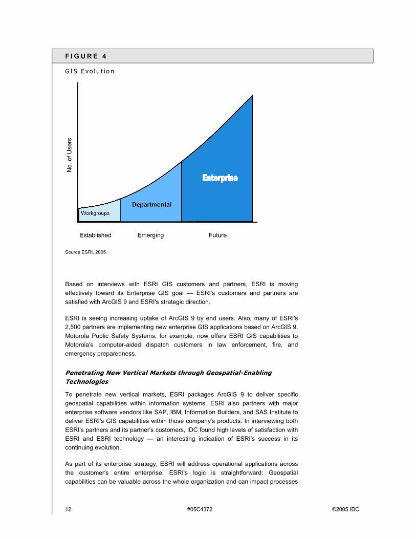
ESRI has served the GIS sector well. As shown in Figure 4, ESRI expects to expand GIS from traditional workgroup implementations to departmental applications to what ESRI calls Enterprise GIS.
These enterprise GIS systems are similar to other business systems in that they share databases and applications across an organization and within multiple business processes.
12 #05C4372 ©2005 IDC
F I G U R E 4
G I S E vo l u t i o n
Source ESRI, 2005
Based on interviews with ESRI GIS customers and partners, ESRI is moving effectively toward its Enterprise GIS goal � ESRI's customers and partners are satisfied with ArcGIS 9 and ESRI's strategic direction.
ESRI is seeing increasing uptake of ArcGIS 9 by end users. Also, many of ESRI's 2,500 partners are implementing new enterprise GIS applications based on ArcGIS 9. Motorola Public Safety Systems, for example, now offers ESRI GIS capabilities to Motorola's computer-aided dispatch customers in law enforcement, fire, and emergency preparedness.
Penetrating New Vertical Markets through Geospatial-Enabling Technologies
To penetrate new vertical markets, ESRI packages ArcGIS 9 to deliver specific geospatial capabilities within information systems. ESRI also partners with major enterprise software vendors like SAP, IBM, Information Builders, and SAS Institute to deliver ESRI's GIS capabilities within those company's products. In interviewing both ESRI's partners and its partner's customers, IDC found high levels of satisfaction with ESRI and ESRI technology � an interesting indication of ESRI's success in its continuing evolution.
As part of its enterprise strategy, ESRI will address operational applications across the customer's entire enterprise. ESRI's logic is straightforward: Geospatial capabilities can be valuable across the whole organization and can impact processes
©2005 IDC #05C4372 13
throughout the enterprise. So it follows that location information should be available to people within an organization who can benefit, including those on the front line.
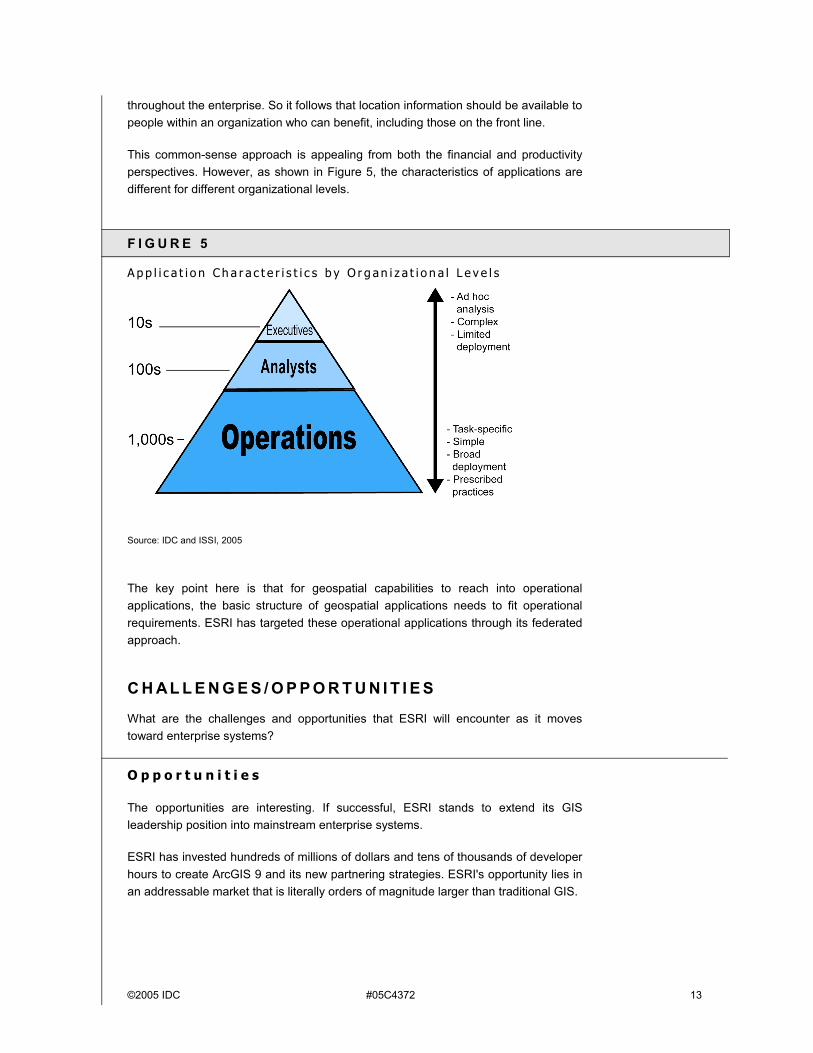
This common-sense approach is appealing from both the financial and productivity perspectives. However, as shown in Figure 5, the characteristics of applications are different for different organizational levels.
F I G U R E 5
A p p l i c a t i o n C h a r a c t e r i s t i c s b y O r g an i z a t i o n a l L e v e l s
Source: IDC and ISSI, 2005
The key point here is that for geospatial capabilities to reach into operational applications, the basic structure of geospatial applications needs to fit operational requirements. ESRI has targeted these operational applications through its federated approach.
C H AL L E N G E S / O P P O R T U N I T I E S
What are the challenges and opportunities that ESRI will encounter as it moves toward enterprise systems?
O p p o r t u n i t i e s
The opportunities are interesting. If successful, ESRI stands to extend its GIS leadership position into mainstream enterprise systems.
ESRI has invested hundreds of millions of dollars and tens of thousands of developer hours to create ArcGIS 9 and its new partnering strategies. ESRI's opportunity lies in an addressable market that is literally orders of magnitude larger than traditional GIS.
14 #05C4372 ©2005 IDC
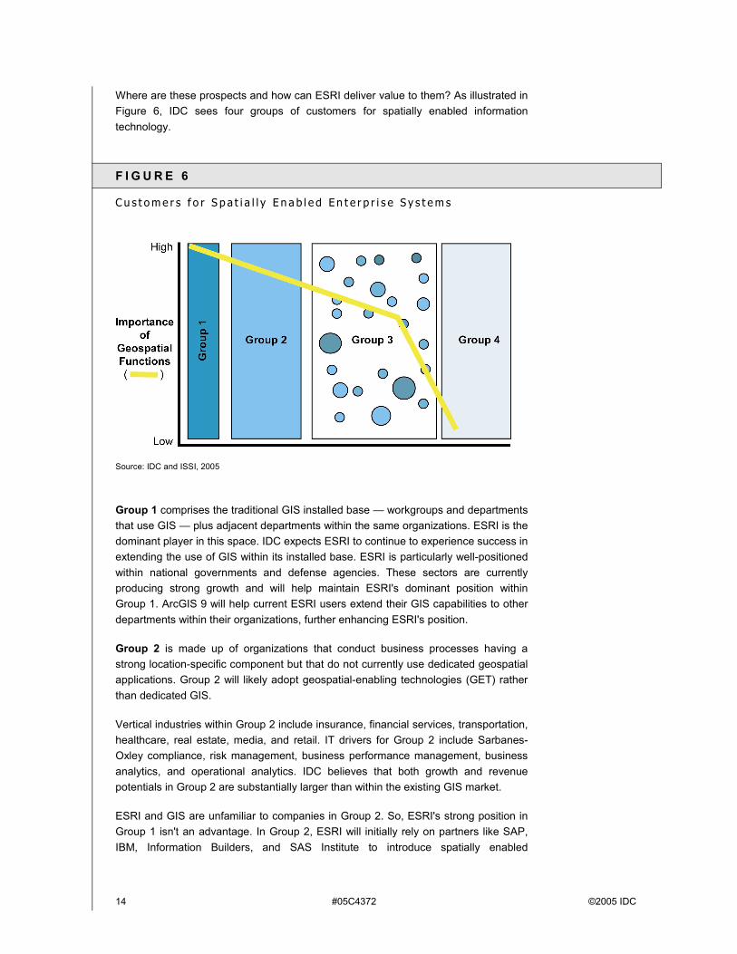
Where are these prospects and how can ESRI deliver value to them? As illustrated in Figure 6, IDC sees four groups of customers for spatially enabled information technology.
F I G U R E 6
C u s t o m e r s f o r S p a t i a l l y E n a b l e d E n t e r p r i s e S y s t e m s
Source: IDC and ISSI, 2005
Group 1 comprises the traditional GIS installed base � workgroups and departments that use GIS � plus adjacent departments within the same organizations. ESRI is the dominant player in this space. IDC expects ESRI to continue to experience success in extending the use of GIS within its installed base. ESRI is particularly well-positioned within national governments and defense agencies. These sectors are currently producing strong growth and will help maintain ESRI's dominant position within Group 1. ArcGIS 9 will help current ESRI users extend their GIS capabilities to other departments within their organizations, further enhancing ESRI's position.
Group 2 is made up of organizations that conduct business processes having a strong location-specific component but that do not currently use dedicated geospatial applications. Group 2 will likely adopt geospatial-enabling technologies (GET) rather than dedicated GIS.
Vertical industries within Group 2 include insurance, financial services, transportation, healthcare, real estate, media, and retail. IT drivers for Group 2 include Sarbanes-Oxley compliance, risk management, business performance management, business analytics, and operational analytics. IDC believes that both growth and revenue potentials in Group 2 are substantially larger than within the existing GIS market.
ESRI and GIS are unfamiliar to companies in Group 2. So, ESRI's strong position in Group 1 isn't an advantage. In Group 2, ESRI will initially rely on partners like SAP, IBM, Information Builders, and SAS Institute to introduce spatially enabled
©2005 IDC #05C4372 15
applications and federated geospatial information management. Over time, ESRI is certainly capable of developing its own vertical applications for Group 2.
Also, ESRI is building strategic relationships with IT infrastructure players like IBM and Microsoft. For example, IBM licenses ESRI technology to extend DB2's spatial capabilities. These relationships have the potential to extend ESRI's technology further into base-level IT infrastructure.
ESRI is seeing some interesting success in Group 2. IDC interviewed a large brewery and beverage distribution company that uses SAP to run its multibillion dollar worldwide operations. It had never heard of ESRI or GIS, but it did have a need to distribute its various products according to customer segments and local regulations.
This company asked SAP for assistance and SAP brought in technology that it licensed from ESRI. The company worked with SAP to modify SAP's Business Warehouse to better use ESRI's technology. Today, the brewery depends on SAP's ESRI-enabled Business Warehouse to manage the distribution of several billion dollars worth of beverages annually.
Group 3 consists of organizations that support business processes with some limited geospatial requirement. Users in this group need simple but specialized vertical applications for some particular task (e.g., CRA/HMDA compliance for banks). The Community Redevelopment Act and the Home Mortgage Disclosure Act require location-specific reports from banks. A small group of software providers service banks with software that gathers the data and generates simple reports.
IDC expects Group 3 to generate interesting but widely disbursed revenues for a number of vertically specialized companies. In this customer group, companies are more likely to use ESRI's point solutions like Business Analyst or Arc Logistics Route rather than comprehensive ArcGIS enterprise solutions.
Group 4 represents noncustomers � organizations that see little or no value in geospatial capabilities. They represent no revenue or growth potential for ESRI or any other geospatial vendor.
C AS E S T U D Y
In researching this paper, IDC interviewed a number of organizations that were using ESRI technology within their enterprise information systems. One of those organizations, the State of Louisiana Department of Social Services (DSS), illustrates the key elements of future enterprise geospatial technology particularly well.
More than 600,000 people in Louisiana receive food stamps each year, representing about $600 million in U.S. Federal funding. Experts estimate that at least 4% of federal food stamp funds are fraudulently received or trafficked.
Customers take food stamps to grocery stores to buy food. However, a few people exchange their food stamps for cash, an illegal practice. DSS found that many of these fraudulent transactions were an even dollar amount, scanned through a cash
16 #05C4372 ©2005 IDC
register quickly, and the customer had driven past several similar grocery stores (DSS can use any set of transaction or geographic criteria).
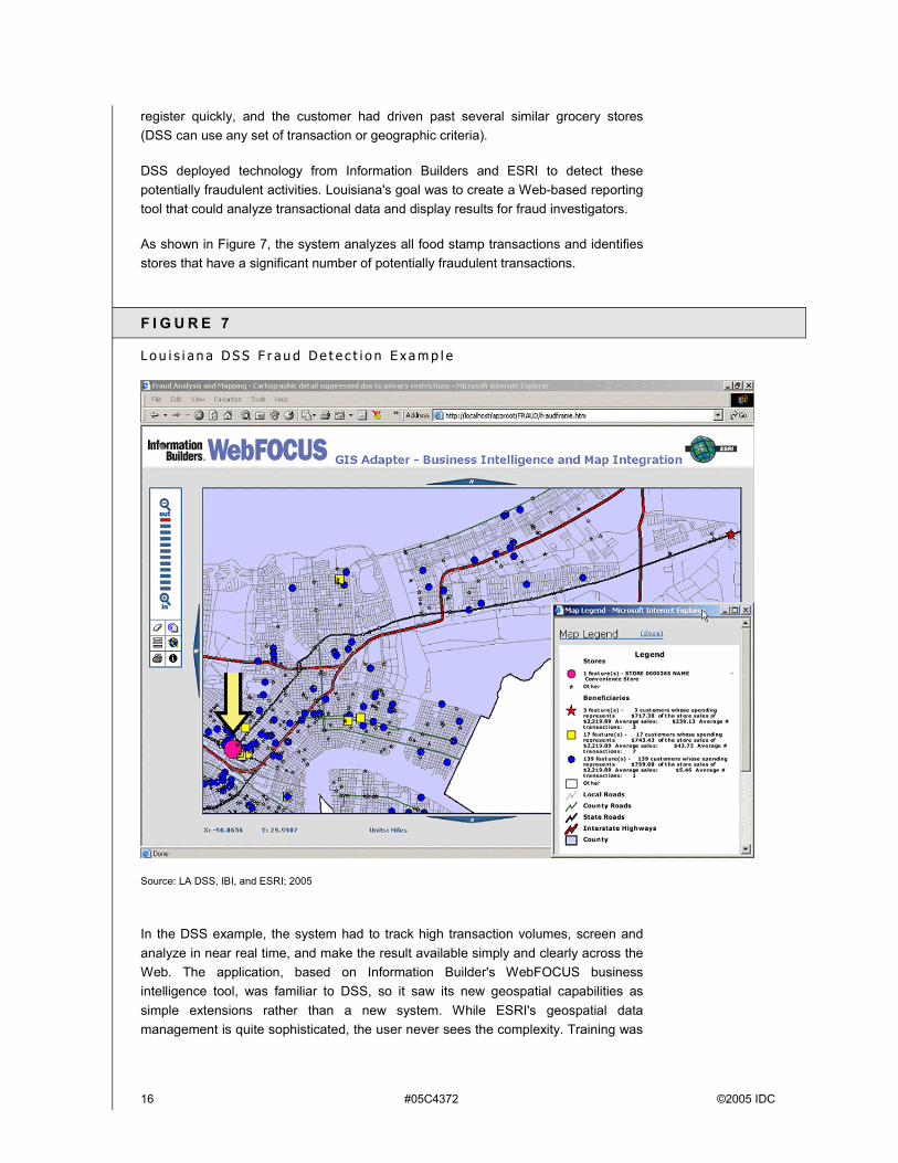
DSS deployed technology from Information Builders and ESRI to detect these potentially fraudulent activities. Louisiana's goal was to create a Web-based reporting tool that could analyze transactional data and display results for fraud investigators.
As shown in Figure 7, the system analyzes all food stamp transactions and identifies stores that have a significant number of potentially fraudulent transactions.
F I G U R E 7
L o u i s i a n a D S S F r a u d D e t e c t i o n E x a m p l e
Source: LA DSS, IBI, and ESRI; 2005
In the DSS example, the system had to track high transaction volumes, screen and analyze in near real time, and make the result available simply and clearly across the Web. The application, based on Information Builder's WebFOCUS business intelligence tool, was familiar to DSS, so it saw its new geospatial capabilities as simple extensions rather than a new system. While ESRI's geospatial data management is quite sophisticated, the user never sees the complexity. Training was
©2005 IDC #05C4372 17
minimal, and enthusiasm is high. These are key characteristics of future spatially enabled enterprise systems.
C h a l l e n g e s
IDC sees three specific issues that ESRI will have to address.
Competition for Position Within IT Infrastructure and Enterprise Applications
Success in enterprise markets will depend on the quality of the integration (with enterprise software) and exposing the right feature set for developers, and ultimately for end users who run spatially enabled applications. This is a different challenge than ESRI has mastered in the dedicated GIS business. In the GIS space, ESRI has provided more sophisticated features and functions to address the increasingly demanding requirements from its installed base.
In the new enterprise space, the key is providing "good enough" functionality that is accessible and useful to new business users who will not tolerate the expense and complexity of dedicated GIS.
Interestingly, ESRI already has over a hundred sites worldwide where its technology has been used to enable business systems (e.g., the Louisiana Department of Social Services and SAP/ beverage distributor cases cited previously).
IT Infrastructure Management Issues
ESRI's enterprise offerings will have to address broad IT infrastructure management issues like security, privacy, and transaction integrity. Major IT infrastructure vendors have time-tested and robust capabilities for managing these issues. ESRI will have to articulate their capabilities very quickly or face a significant competitive disadvantage.
To be fair, ESRI's technology has been implemented in highly secure situations like defense and military intelligence. ESRI will learn from those experiences and is likely to adjust its offerings to meet security and privacy requirements.
Changing Business Approach and License Models for Unfamiliar Business Markets
The enterprise space is unfamiliar territory for ESRI and other geospatial players. Also, the business community is clearly dissatisfied with current IT licensing and distribution practices. These two factors combine to create difficult pricing and licensing issues. This problem is particularly acute for vendors like ESRI that are accustomed to relatively high margins and control of their customer accounts. ESRI has demonstrated flexible and innovative business models in the past. The enterprise market is likely to require even more from them.
18 #05C4372 ©2005 IDC
C O N C L U S I O N
ESRI's enterprise strategy and products are ambitious and comprehensive. IDC believes that the following seven factors will have a deciding impact on ESRI's success:
! ESRI has a large, satisfied user base that gives ESRI a solid launching point for enterprise products.
! ESRI's ArcGIS 9 partners and users are generally satisfied with the new products.
! ESRI's enterprise partners, like SAP, Information Builders, IBM, and SAS Institute, are satisfied with ESRI software and are seeing significant new business from ESRI-enabled products.
! ESRI has a long history of maintaining enduring relationships with its customers.
! ESRI is well managed and in excellent financial health.
! Broad IT markets are ready for new spatially enabled enterprise solutions.
! External competitive factors, such as licensing, IT infrastructure management issues, and competition from large, well-established companies, present significant and unpredictable challenges.
ESRI will have to adapt to its new role as complementary to IT infrastructure and enterprise applications like BI, CRM and ERP. It will have to penetrate enterprise applications with OEM-like partnerships with key enterprise players. If it can respond quickly to these new competitive situations, it will become a significant force in future information systems.
C o p y r i g h t N o t i c e
External Publication of IDC Information and Data � Any IDC information that is to be used in advertising, press releases, or promotional materials requires prior written approval from the appropriate IDC Vice President or Country Manager. A draft of the proposed document should accompany any such request. IDC reserves the right to deny approval of external usage for any reason.
Copyright 2005 IDC. Reproduction without written permission is completely forbidden.