Embed Size (px)
Citation preview
Whitnash Neighbourhood Development Plan
Submission Draft 2015 - 2029
Report of Examination July 2015
Undertaken for Warwick District Council with the support of Whitnash Town Council on the submission version of the plan.
Independent Examiner:
Liz Beth BA (Hons) MA Dip Design in the Built Environment MRTPI
2
Contents
Page
Summary 3
1. Introduction and background
1.1 Neighbourhood Development Plans 4
1.2 Independent Examination 4
1.3 Basic Conditions and Plan Compliance 5
1.4 Planning Policy Context 7
2. Plan Preparation and Consultation
2.1 Pre-submission Process and Consultation 9
2.2 Reg16 Consultation Responses 10
3. The Whitnash Neighbourhood Development Plan
3.1 General Considerations 12
3.2 Neighbourhood Plan Policies and Compliance with National Policy 13
4. Summary of Modifications required 25
5. Referendum Recommendation 26
6. Appendix 1: Typographical and other minor errors in the text. 27

3
Summary
I have undertaken the examination of the Whitnash Neighbourhood Development
Plan during July 2015 and detail the results of that examination in this report.
Subject to the recommended modifications in Section 3 being made to the
satisfaction of the Local Planning Authority, the Plan meets the basic conditions and
may proceed to referendum.
I recommend a slight change to the area of the referendum boundary from the
designated neighbourhood plan area, due to recent minor boundary changes to the
parish boundary of the Town Council’s area.
Abbreviations used in the text of this report:
The Whitnash Neighbourhood Development Plan is referred to as ‘the Plan’ or ‘Whitnash
NDP’.
Whitnash Town Council is abbreviated to ‘Whitnash TC’.
Warwick District Council is abbreviated to ‘Warwick DC’.
The National Planning Policy Framework is abbreviated to ‘NPPF’.
Acknowledgements:
The co-operation and speedy responses to requests for information from the Town Clerk
for Whitnash TC and the Planning Policy officer at Warwick DC is gratefully acknowledged.
4
1. Introduction and Background
1.1 Neighbourhood Development Plans
1.1.1 The Localism Act 2011 empowers local communities to develop planning policy for
their area by drawing up neighbourhood plans. For the first time, a community-led plan
that is successful at referendum becomes part of the statutory development plan for their
planning authority.
1.1.2 Giving communities greater control over planning policy in this way is intended to
encourage positive planning for sustainable development. The National Planning Policy
Framework (NPPF) states that:
“neighbourhood planning gives communities direct power to develop a shared vision for
their neighbourhood and deliver the sustainable development they need”.Further advice on
the preparation of neighbourhood plans is contained in the Government’s Planning
Practice Guidance website:
http://planningguidance.planningportal.gov.uk/blog/guidance/neighbourhood-planning/.
1.1.3 Neighbourhood plans can only be prepared by a ‘qualifying body’, and in Whitnash
this is the Town Council. As is usual, a steering group led the process comprising local
residents as well as councillors. The steering group worked for over two years on the plan,
and was assisted by planning consultancy Kirkwells during this time.
1.2 Independent Examination
1.2 1 Once Whitnash TC and the steering group had prepared their neighbourhood plan
and consulted on it, they submitted it to Warwick DC. After publicising the plan with a
further opportunity for comment, Warwick DC were required to appoint an Independent
Examiner, with the agreement of Whitnash TC to that appointment.
1.2.2 I have been appointed to be the Independent Examiner for this plan. I am a
chartered Town Planner with thirty years of local authority and voluntary sector planning
experience in development management, planning policy and project management. I have
been working with communities for many years, and have recently concentrated on
supporting groups producing neighbourhood plans. I have been appointed through the
Neighbourhood Plan Independent Examiners Referral Service (NPIERS). I am
5
independent of any local connections to Whitnash, Whitnash TC, and Warwick DC, and
have no conflict of interest that would exclude me from examining this plan.
1.2.3 As the Independent Examiner I am required to produce this report and recommend
either:
(a) That the neighbourhood plan is submitted to a referendum without changes; or
(b) That modifications are made and that the modified neighbourhood plan is
submitted to a referendum; or
(c) That the neighbourhood plan does not proceed to a referendum on the basis that
it does not meet the necessary legal requirements.
1.2.4 The legal requirements are firstly that the plan meets the ‘Basic Conditions’, as
discussed in section 1.3 below. The plan also needs to meet the following requirements
under Paragraph 8(1) of Schedule 4B to the Town and Country Planning Act 1990:
It has been prepared and submitted for examination by a qualifying body;
It has been prepared for an area that has been properly designated by the
Local Planning Authority;
It specifies the period during which it has effect;
It does not include provisions and policies for excluded development;
It does not relate to land outside the designated neighbourhood area.
The Whitnash NDP complies with all of the above, except for some minor inclusion in
maps of land outside the designated area. I have indicated where these occur in the
recommended modifications to policies section 3.2 below.
1.2 5 I made an unaccompanied site visit to Whitnash to familiarise myself with the area
and visit relevant sites and areas affected by the policies. This examination has been
dealt with by written representations, as I did not consider a hearing necessary. I have
requested supplementary information to assist this examination from both the qualifying
body and Warwick DC, copying both parties into each request. These requests comprised
questions requiring short answers only and both parties were offered the opportunity to
comment on the Reg16 consultation responses.
1.2.6 I am also required to consider whether the referendum boundary should be
extended beyond the designated area, should the Plan proceed to a referendum. I make
my recommendation on this in section 5 at the end of this report.
6
1.3 Basic Conditions and Plan Compliance
1.3.1 The most significant role of the Independent Examiner is to consider whether a
neighbourhood plan meets the “Basic Conditions.” These are set out in paragraph 8(2) of
Schedule 4B to the Town and Country Planning Act 1990 as applied to neighbourhood
plans by section 38A of the Planning and Compulsory Purchase Act 2004. In order to meet
the Basic Conditions, the neighbourhood plan must:
Have regard to national policies and advice contained in guidance issued by the
Secretary of State;
Contribute to the achievement of sustainable development;
Be in general conformity with the strategic policies of the development plan
for the area; and
Be compatible with and not breach European Union (EU) obligations and human
rights law.
1.3.2 Section 3 of this report considers whether the plan meets the first of these Basic
Conditions, and where necessary recommends modifications to the plan in order that it
does meet them. These recommended modifications are summarised in section 4.
1.3.3 The second Basic Condition is that neighbourhood plans and their policies deliver
sustainable development. The Basic Conditions Statement submitted with the Whitnash
NDP discusses this on pages 9 and 10, and helpfully sets out how the Plan will deliver
sustainable development with regard to the three pillars of sustainable development; the
economic, social and environmental aspects of sustainability. I agree with the
conclusions in the Basic Conditions Statement that the Plan delivers Sustainable
Development, and this requirement of the Basic Conditions has been complied with.
1.3.4 The relevant development plan is the Warwick District Local Plan 1996 – 2011
(saved policies). I can confirm, as have Warwick DC verbally, that the policies in the
Whitnash NDP are in general conformity with the strategic policies of this plan, and
so the Basic Conditions are complied with in this regard.
1.3.5 Whether the Whitnash NDP complies with Human Rights Law is also considered in
the Basic Conditions Statement submitted with the Plan (pages 56-7). This document
summarises the discussion thus:
7
“In general, the policies and proposals will not have a discriminatory impact on any
particular group of individuals.”
I agree with this statement, and no assertion to the contrary has been made. Thus I
consider the plan complies with Human Rights legislation and complies with the
Basic Conditions in this regard.
1.3.6 The key EU obligation for landuse plans is compliance with the Environmental
Assessment of Plans and Programmes Regulations 2004. A recent amendment (January
2015) to the Neighbourhood Planning Regulations requires either that a Strategic
Environmental Assessment (SEA) of the plan is undertaken if necessary, or a formal
screening opinion is obtained setting out the reasons why an SEA is not required.
1.3.7 Regulations 32 and 33 of the Neighbourhood Planning (General) Regulations 2012
(as amended) require that the Neighbourhood Plan should not be likely to have a
significant effect on a European Site or a European Offshore Marine Site, either alone or in
combination with other plans or projects. The screening opinion normally considers
whether there is any significant effect on a European Site that would require a Habitats
Regulations Assessment as well as whether an SEA is required.
1.3.8 Whitnash Town Council obtained a screening opinion from Warwick DC which was
submitted with their Plan to Warwick DC. This states (page 10) that:
“It is considered unlikely there will be any significant environmental effects arising
from the Whitnash Neighbourhood Plan that were not covered/addressed in the
Sustainability Appraisal of the Local Plan. As such, it is considered that the Whitnash
Neighbourhood Development Plan does not require a full SEA to be undertaken.”
1.3.9 The screening opinion also states (page 10) that:
“A Habitats Regulation Assessment (HRA) of the Local Plan has also been produced
and reported on separately that is also considered relevant in the assessment of the
environmental effects of the Whitnash Neighbourhood Development Plan. It is
unlikely that the Whitnash NDP will have a significant effect on important Habitat /
Biodiversity assets.”
1.3.10 I consider therefore that the Whitnash NP complies with EU obligations with
respect to environmental considerations for a development plan.
8
1.4 Planning Policy Context
1.4.1 The Development Plan for Warwick DC is the Warwick District Local Plan (saved
policies) 1996 - 2011; the Minerals Local Plan 1995 (saved policies); and the Waste Core
Strategy Local Plan 2013 – 2028. The new Warwick District Local Plan 2011 – 2029
Publication Draft is currently at examination, and whether or not the Whitnash NDP
complies with it is not relevant for the purposes of assessing compliance with the basic
conditions. The Town Council have however considered how their Plan complies with the
emerging Local Plan in their Basic Conditions Statement, and they will review their Plan
should the Whitnash NDP not comply with strategic policies in the new Local Plan when
finally adopted.
1.4.2 The National Planning Policy Framework (NPPF) sets out government planning
policy for England, and the National Planning Policy Guidance website offers guidance on
how this policy should be implemented.
1.4.3 During my examination of the Whitnash NDP I have considered the following
documents:
National Planning Policy Framework (NPPF) 2012
Town and Country Planning Act 1990 (as amended)
Planning and Compulsory Purchase Act 2004
The Localism Act 2011
The Neighbourhood Planning Regulations 2012 (as amended)
Submission version of the Whitnash NDP
Basic Conditions Statement
Consultation Statement
Strategic Environmental Assessment Screening Opinion
Whitnash Neighbourhood Area (map)
Warwick District Local Plan 1996 – 2011 (saved policies)
Warwick District Local Plan 2011 – 2029 Publication Draft feb2015
Warwick Strategic Flood Risk assessment 2013
Warwick Sites for Gypsies and Travellers Preferred Options for Sites March2014
Green Space Strategy for Warwick District 2012 - 2026
Representations received during the publicity period (reg16 consultation)

9
2. Plan Preparation and Consultation
2.1 Pre-submission Process and Consulation
2.1.1 Whitnash is a small town located to the south of Leamington Spa, about 3 miles
from Warwick with a population of nearly 9,000 people. It became a town in 1972 when
the Town Council was established. Most of the built form is recently constructed
residential estates, but there is a small historic core. There are three small neighbourhood
shopping areas, and reasonable community facilities including a library and four schools.
2.1.2 Whitnash Town Council (Whitnash TC) formally approved the preparation of a
neighbourhood plan in 2012, and in September 2012 an application for designation as a
neighbourhood planning area was made to Warwick District Council (Warwick DC). This
was approved on the 9th January 2013.
2.1.3 A Steering Group of Town Councillors and Residents was set up in January 2013,
and the group has met regularly since throughout the plan preparation period.
Involvement in the plan by local residents was frequently promoted, including at the
Annual Parish Meeting of the Town Council in 2013 and the Community Fun Day in the
summer of 2013.
2.1.4 The quarterly local newsletter, the Whitnash Tymes, gave updates on progress
during 2014, and informal consultation on the emerging vision, objectives and issues was
also undertaken in the summer of 2014. A decision was taken not to consider allocation of
housing sites in the plan, as this work had effectively been done at a strategic level in the
emerging Local Plan.
2.1.5 As required by regulation 14 of the Neighbourhood Planning Regulations 2012, the
formal consultation for six weeks on the pre-submission Whitnash Draft Neighbourhood
Development Plan ran from Wednesday 1st October 2014 to Wednesday 12th November
2014. The plan and a response form could be downloaded from the Town Council and
District Council websites. Hard copies were available at the local library and the own
Council offices. Local community organisations and local businesses were notified of the
consultation opportunity, as were other statutory consultees (detailed in the Consultation
Statement submitted to Warwick DC with the neighbourhood plan).
2.1.6 Further publicity around this consultation included a banner in the centre of
Whitnash, posters in local shops, the library and other prominent locations, and press
10
releases and coverage. School children were targeted with ‘fuzzy bugs’ promoting the
neighbourhood plan! Members of the Steering Group also visited local groups and
organisations during the consultation period to encourage comments from as wide a range
of the community as possible.
2.1.7 Seventy six representations were received during the consultation period, and
several amendments have been made to the plan as a result of constructive suggestions
for changes. Objections from a house-builder and Warwick DC also resulted in changes to
plan policies, in order to comply with strategic policy allocations in the emerging Local Plan
and other council planning policy. These are clearly detailed in the consultation statement.
2.1.8 I am satisfied that due process has been followed during the consultation
undertaken on the Plan. The record of comments and objections received during the
regulation 14 consultation shows that these were properly considered, and where
appropriate resulted in amendments to the plan to accommodate points raised.
2.1.9 As required, the amended plan, together with a Basic Conditions Statement, a
Consultation Statement, the Screening Opinion and a plan showing the neighbourhood
area (in the Consultation Statement) was submitted to Warwick DC on the 23rd January
2015.
2.2 Regulation 16 Consultation Responses
2.2.1 Publicity and consultation on the plan undertaken by Warwick DC after submission,
as required by regulation 16 of the Neighbourhood Planning Regulations 2012 (abbreviate
NPR2012), resulted in six comments from national and local organisations.
2.2.2 Historic England welcomed the amendments to the plan as a result of previous
comments and welcomed the plan’s treatment of the historic environment. Natural
England also supported the plan, and the provision for green infrastructure.
2.2.3 The Highways Agency supported the plan and Warwickshire County Council, the
highway authority, supported policies promoting sustainable travel, although they declined
to comment further until they had seen the detail of actual proposals.

11
2.2.4 Warwick DC made no further comment, they informed me this was because they are
now satisfied that the Plan meets the Basic Conditions with regard to complying with the
development plan for Warwick.
2.2.5 Coventry and Warwickshire Growth Hub (CWGH) welcomed support for small
businesses and alterations made to the Plan in the light of previous comments they made.
They express concern however that Policy W13 would not support mixed use development
if it resulted in the loss of open space or green infrastructure, and that this policy needed to
be made consistent with Policy W7 and the Local Green Space designations it makes, in
particular Area 8. As Area 8 proposed for designation of Local Green Space has been
altered to exclude the gypsy and traveller site I do not see a consistency problem between
the two policies, and, as discussed below, I find Policy W13 acceptable as it is currently
worded. Policy W7 is also discussed further below, and this may indirectly address the
concerns raised by CWGH.
2.2.6 The Health and Safety Executive raised the presence of three National Grid feeder
pipelines in the neighbourhood plan area and recommended that their presence should be
shown on any proposals map. This request I am happy to recommend as a suggested
modification to the Plan. A reference to the pipelines, and the need to respect the
consultation zones associated with them, can be accommodated in Policy W8, a policy
dealing with the open area to the south of Whitnash in which the pipelines are located.
This is detailed in the recommended modification to this policy at paragraph 3.2.32 below.
12
3. The Whitnash Neighbourhood Development Plan
3.1 General Considerations
3.1.1 The Whitnash NDP is a generally well-written document and easy to read. The
policies flow well from the vision and objectives. The group are to be complemented on a
proportionate and well-structured document. I have noted a few textual errors in a short
appendix to this report.
3.1.2 For the purposes of meeting the basic conditions a critique of introductory sections
and descriptions is not normally appropriate. However the discussion of the emerging
Warwick District Local Plan in paragraph 2.5 is somewhat out of date now, and could be
usefully updated in the final version.
3.1.3 The discussion of the relative strengths of the Local Plan and the Whitnash NDP in
paragraph 1.19 is not wholly accurate, and I would recommend a revision on the following
lines:
“When it is made, policies in the Neighbourhood Plan will take precedence over the
non-strategic policies of the existing adopted Local Plan. The review of the 1996-
2011 Local Plan is at an advanced stage and this has been taken into account in the
Neighbourhood Plan. Policies and allocations in the Publication Draft Plan 2011-
2029 have therefore been considered within the Whitnash NDP. When the new Local
Plan is adopted, the Whitnash NDP will be reviewed to take account of this,
particularly if any policies are no longer in compliance with strategic policies in the
new Local Plan. The NPPF (para185) recommends that emerging local plans do not
duplicate non-strategic policies in neighbourhood plans.”
3.1.4 What follows is a more detailed consideration of the policies in chapter 5 of the
Whitnash NDP and whether or not they meet the first basic condition that they comply with
National policy. In order to comply with national planning policy they need to be clear in
intent (NPPF paragraph154), so my recommendations for modifications will include
alterations for reasons of clarity as well as overall compliance with national planning policy.
13
3.2 Neighbourhood Plan Policies and Compliance with National Policy
3.2.1 This section considers each policy in turn, and where necessary recommends
modifications needed in order that the policy meets the requirements of the Basic
Conditions in terms of complying with national policy. As discussed above in Section 1.3,
the Whitnash NDP meets the requirements of the other Basic Conditions unaltered.
3.2.2 Policy W1 A New Community Hub for Whitnash
A lot of preparatory work on the project has been done, including a feasibility study
currently being undertaken. The policy justification details this and other considerations
well. The Town Council have confirmed that although the Acre Close site is looking the
most likely place for the Hub, they are not ready to formally allocate the site. Therefore for
clarity and consistency, reference to this site will need to be removed from policy W1
(second paragraph) so that it is a ‘support in principle’ policy not a site allocation policy.
3.2.3 The second paragraph does not read clearly at present, however I have assumed it
is the careful siting, parking provision and landscaping that will complement and enhance
existing local retail facilities.
3.2.4 The second sentence of the first paragraph is very specific about what the Hub will
need to include, but as a site has not yet been chosen this is not appropriate. Therefore
my recommendation is that this wording is changed to be less prescriptive. This list of
uses required within the hub includes the phrase “local retail-type uses”, which is not clear
and does not indicate well what is intended. I recommend that this phrase is replaced with
the range of planning retail uses (from A1 to A5 as defined in the Use Classes Order) that
would be considered acceptable in the Hub.
3.2.5 Policy W1 is recommended to be modified as follows:
“Proposals for a new Community Hub for Whitnash will be supported in principle.
The Community Hub is encouraged to include the following development:
A new community centre to meet the needs of local residents and groups.
A civic centre which provides office space and a focus for the activities of the
Town Council.
A new library with internet facilities.
A police station.
Healthcare facilities and

14
Other suitable community and retail uses (A? – A?).
The Community Hub will complement and enhance any existing local retail facilities
adjacent through careful siting and location and the provision of improved parking
and high quality landscaping.
Detailed proposals will be informed by the results of a feasibility study which
will be commissioned to consider the cost implications, proposed uses, access
and siting of the proposed Community Hub.”
3.2.6 Policy W2 Protection of Local Centres and Community Facilities
The policy speaks of “defined neighbourhood centres” but there is no plan showing the
defined areas. I suspect the definition in the Local Plan is referred to, but for clarity a
map showing these defined areas should be included in the Whitnash NDP.
The use of the phrase “local needs retail” is not clear in a planning sense. This should be
simply “retail” or alternatively specify which retail uses would be acceptable (from A1 – A5
as defined in the Use Classes Order 1987 as amended).
3.2.7 You will be aware that recent changes to permitted development rights as regards
retail conversion to residential could severely restrict the ability of this policy to provide the
protection you wish it to. The definition of the local centres could be taken to indicate
areas where a planning application will normally be required for any such permitted
change, and you may wish to consider this further and amend the policy as required. I
make no recommendation on this point however.
3.2.8 The meaning of paragraph 3 is not clear. The use of “may be allowed…” suggests
that there are undefined circumstances where residential uses on the first floor level will
not be allowed. Additionally I am not clear what is implied by “where these are part of a
mix”. The use of the term “commercial” is not specific in a planning sense, and I have
substituted it as seems best. The planning authority can review my modifications of
course should they wish to and consult with the Whitnash TC on the changes.
15
3.2.9 Paragraph 4 of this policy is protecting an unspecified range of facilities as
“Community Assets”. It should be understood that this not the same as the formal
designation under powers in the Localism Act of an “Asset of Community Value”, as the
Town Council have confirmed they have not registered any of them under this power. If
the policy is to be clear it needs to specify which facilities are to be designated, and for the
avoidance of doubt I would recommend use of the term “Community Facilities” rather than
“Community Assets”. You may want to consider a separate policy for this section, but I
offer this as a suggestion only.
3.2.10 The Town Council have helpfully supplied a list of facilities they would wish to be
named as Community Facilities to be protected in community use, and I have included this
in my recommended alterations to the policy below. Ideally the owners of these premises
should be consulted before the policy names them however, and you may prefer to include
this list in the justification rather than the policy if you cannot get owners agreement.
3.2.11 The retention of these facilities in community use is a reasonable aspiration and
policy, but it is not reasonable to require an applicant for a change of use to demonstrate
that there is no longer a need for the facility “to the satisfaction of the Town Council”. The
Town Council do not have formal standing within the determination of any future planning
application to be able to adjudicate in this way. Thus I am proposing this requirement of
the policy be modified as shown below, or deleted if the Local Planning Authority are not
happy with the suggested modification.
3.2.12 Policy W2 is recommended to be modified as follows:
A plan showing the defined centres needs to the produced. The policy to read as
follows:
Within the defined neighbourhood centres (see map ….) of:
Heathcote Road / Acre Close
Coppice Road and
Home Farm Crescent
Development for retail (A? to A? uses?) and community facilities will be permitted.
16
The loss of retail and community uses in these centres will be resisted and
proposals for changes of use from retail or community use to residential uses at
ground floor level in the defined local centres will not be permitted.
Residential uses will normally be allowed at first floor level to safeguard the vitality
of the relevant centres where ground floors are retained in retail or community use.
The following local Community Facilities are to be protected for community use:
The Whitnash Community Centre
The Whitnash Sports & Social Club
St Margaret’s Church Centre
Whitnash Medical Centre
Whitnash Library
St Margaret’s Church
Whitnash Methodist Church
St Joseph’s Catholic Church
There will be a presumption in favour of the retention of any community facility for
health and community uses. The change of use of the Community Assets defined
above to other uses will not be permitted unless the following can be demonstrated:
(a) The proposal includes alternative provision, on a site within the locality, of
equivalent or enhanced facilities. Such sites should be accessible by public
transport, walking and cycling and have adequate car parking; or
(b) There is no longer a need for the facility, and this can be demonstrated
to the satisfaction of the Local Planning Authority advised by the Whitnash Town
Council.
3.2.13 Policy W3 Protecting Local Heritage and Identifying a Local Heritage List
This policy complies with the basic conditions. You may however wish to alter the last
sentence to “protect and enhance”.
17
3.2.14 Policy W4 Building Design Principles
What needs to be submitted with a planning application is defined by national regulation,
and a neighbourhood plan policy cannot ‘require’ a development proposal to include other
information in the application. The policy can ‘encourage’ this, and if a design and access
statement is required, as it is within conservation areas, then you can specify that this
document should demonstrate something – as you have in point 1.
3.2.15 Point 2 needs to refer more accurately to ‘Design and Access Statements’, and
qualify that this is to happen if a Design and Access Statement is required to be submitted.
However with the modification to the first paragraph the entire reference can be removed
as repetition.
3.2.16 Policy W4 is recommended to be modified as follows:
1st paragraph: All new development proposals and particularly those within or in
close proximity to Whitnash Church Green and Chapel Green Conservation Area are
encouraged to demonstrate how they have taken account of the following issues.
Development proposals that are required to submit a Design and Access Statement
should address the following points within that document:
2nd paragraph last sentence: Proposals should not feature designs specific to a
generic “scheme” and should take account of the locally distinctive character of the
area in which they are to be sited.
3.2.17 Policy W5 Improved Linkages to Proposed Country Park at Tach Brook
This policy complies with the basic conditions. As an observation only I would comment
that the second sentence is justification for the policy rather than needed within the policy,
and would be better out of the policy. The policy would also read better if before the final
bullet points the phrase “The following improvements are supported and encouraged:” is
added.
18
3.2.18 Policy W6 Protection and Enhancement of Whitnash Brook and Brook Valley
Map 6 includes land directly to the east of the school and estate around St Fremund Way
that is not within the designated neighbourhood plan area, and should therefore be
removed. The correct boundary will continue the southern boundary of the Campion
School and the estate to end the nature reserve and wildlife Buffer’s northern boundary at
this point. The plan has a ‘9’ written within the green area, but it is not clear what this
refers to, and there is no key that makes it clear if the green area shown is either the
Nature Reserve, or the wildlife buffer, or both. This needs to be corrected.
3.2.19 Map 7 also shows a footpath to the east of the St Fremund Way estate as a
footpath within the neighbourhood plan area when it is actually outside the area for much
of its length. All paths outside of the area should be shown grey as the key on the map. I
understand from the Ordnance Survey map that the blue dashed routes are sometimes
bridleways rather than footpaths, and the key should be corrected to include this
information (a ‘bridleway’ is not the same as a ‘cycleway’).
3.2.20 Recommended modifications to map 6 and map 7: Map 6 needs to redefine the
area shown green to comply with the designated neighbourhood plan area, and show in a
key what the nature of the area shown green is. Map 7 needs to amend the colour and
designation of some of the paths shown as discussed above.
3.2.21 The last paragraph of Policy W6 is not clear in what way the route of the Brook
Valley bridleway is to be ‘protected’. Additionally the plan cannot protect the whole route
to Radford Semele as suggested, because much of this bridleway is outside of the
designated neighbourhood plan area. I suspect views towards Black Bridge (the railway
bridge) from the bridleway may be outside of the neighbourhood plan designated area as
well. There has been no analysis of important views undertaken to inform the required
protection of the view and where it is, and so this requirement of the policy is also not
clear. The second sentence, however, does makes clear the treatment the Town Council
wishes to see of any construction of the bridleway within new development.
3.2.22 Policy W6 is recommended to be modified as follows:
Last paragraph: The route of the Brook Valley bridleway linking Whitnash to Radford
where it runs within the neighbourhood plan area will remain open in character and
19
should not follow an enclosed narrow corridor between high walls or other visually
intrusive and inappropriately high boundary treatment through the proposed
housing estate.
3.2.23 Policy W7 Local Green Space Designations
This policy has generally justified the proposed allocations well in Table 1, and map 8
shows the areas they cover clearly, but there are inconsistencies and anomalies that need
to be corrected on the map.
3.2.24 The numbering system on the map needs to be consistent with the numbering of
the designations used in Policy 7, and the names of the two small greens differ from the
policy to the map. There is a potential problem in that there are three areas of allotments
shown on the plan, but only two referred to in the policy and discussed in Table 1. As the
plan has clearly shown three allotment areas, should the local planning authority accept
that all three areas of allotments should be designated as Local Green Space this will be
acceptable, but the policy and justification need to be consistent with the plan. I note that
in the emerging Local Plan Warwick DC propose that designation of Local Green Space
will be a matter for neighbourhood plans (Policy HS3 page 35 publication draft Feb2015),
so I would expect them to confer with the Town Council on this point.
3.2.25 The policy should not refer to the NPPF; the justification has comprehensively
made reference to this national policy and the Local Green Space is designated (not
allocated) by the policy in the Whitnash Plan, not the NPPF.
3.2.26 As part of my site visit I took a careful look at the proposed designation of the
‘Arable Land’ to the south of the neighbourhood plan area, Area 8 at present on Map 8.
My initial consideration of the policy suggested to me that this proposed designation did
not comply with the requirements of the NPPF paragraphs 76 and 77. It appeared to be
an extensive tract of land, somewhat isolated from the community and urban area of
Whitnash, being the other side of the golf course that fringes the southern extent of the
town.
3.2.27 My site visit did not reveal to me any defining characteristic about Area 8 that
makes it special, it is farmland with a variety of agricultural uses undertaken on it. There is
some documented indication of historic field remnants on a part of the site, but this is not a
defining characteristic of the whole site. If the historic features are found worthy of
protection then this should be undertaken under alternative legislation. In summary Area 8
20
has not been demonstrated to be special in a way required by the NPPF paragraph 77. It
is an extensive tract of land, with ill-defined boundaries and too isolated from the
community to comply with the requirement that it should be in ‘reasonable proximity’ to the
community it serves. Thus in order to comply with the basic conditions this designation of
Area 8 as Local Green Space needs to be removed from the plan.
3.2.28 I appreciate that the open countryside nature of this land is valued by the
community, but this is protected, as far as a neighbourhood plan is able, by the proposed
policy W8 which is discussed below.
3.2.29 Policy W7 is recommended to be modified as follows:
The following sites are designated as Local Green Space:
1. Chapel/Town Green
2. Church Green
3. Washbourne Fields
4. Dobson Lane Allotments
5. Golf Lane Allotments
6. ? ? Allotments
7. Leamington and County Golf Course
8. Whitnash Brook Valley (as shown on map 6)
New development which impacts adversely on the openness of these sites or
adversely affects the attributes for which they were designated will not be
acceptable other than in very special circumstances.
The Local Green Spaces are shown on Map 8 below.
3.2.30 Recommended modifications to Map 8: for clarity and consistency the
corrections noted in paragraph 3.2.24 above need to be made. In line with the
recommended modifications to Policy 7, Area 8 ‘Arable Land’ should no longer be shown
as designated as Local Green Space.
3.2.31 Policy W8 Protection of Open Area to the South of Whitnash
As discussed in paragraph 2.2.6 above, this policy suggests itself to me as the best place
to accommodate the Health and Safety Executive’s request that the Plan shows the
21
location of the National Grid gas feeder pipelines. The rest of the policy complies with the
basic conditions.
3.2.32 Policy W8 is recommended to be modified to acknowledge the gas feeder pipelines
crossing the neighbourhood plan area, and refer to a plan that shows where they are, and
preferably also shows at least the inner consultation zone for each pipeline within the
neighbourhood plan area. I would suggest wording as follows in a separate paragraph at
the end of the policy:
“Attention is drawn to the presence of three National Grid gas feeder pipelines in this
area as shown on Map…. Any development will need to respect the consultation
zone requirements of the Health and Safety Executive for these piplines.”
3.2.33 Policy W9 Landscape Design Principles
Point 4 in the policy requires the submission of a ‘visual landscape impact assessment’
with development proposals. The documents required to be submitted with a planning
application are set out in national regulations however, so the phrase here should be “are
encouraged to demonstrate”.
3.2.34 Point 5 in the policy requires that views from “Chesterton Windmill” are protected.
Chesterton Windmill is outside the designated neighbourhood plan area and this reference
should be deleted.
3.2.35 Policy W9 is recommended to be modified as follows:
Point 4: Development proposals on the urban fringe are encouraged to demonstrate
consideration of visual impacts on local landscape through a visual landscape
impact assessment. Layout and design should provide an appropriate transition
from rural to urban areas, such as inclusion of lower densities around the edges
and suitable landscaping schemes.
Point 5: Proposals for new development on open land to the south of Whitnash
should demonstrate consideration of the historic route of the Fosse way corridor.
22
3.2.36 Policy W10 Improving Accessibility for All
The policy is generally well justified, but the first two bullet points deal with highway
improvement issues not landuse. This means that they have no place in a landuse
planning policy and should be deleted. The third bullet point can incorporate the possibility
of widening pavements (footways) for cycle use if it is altered to read “…the design of new
and existing roads;” In this way the aspiration is included in a policy that is discussing the
landuse issue of better cycle routes without specifying the particular remedy using powers
under the Highways Acts.
3.2.37 Policy W10 is recommended to be modified as follows:
Bullet points one and two to be removed.
Bullet point three (becomes one) to read:
“Incorporating the provision of safe cycle routes into the design of new and existing
roads;”
3.2.38 Policy W11 Housing Mix
This policy complies with the basic conditions.
3.2.39 Policy W12 Employment Provision.
This policy complies with the basic conditions. You may want to consider including a
provision that the residential amenity of neighbours is not unacceptably impacted, but this
is a suggestion only.
3.2.40 Policy W13 Encouraging a Mix of Uses
This policy complies with the basic conditions.
3.2.41 Policy W14 Sustainable Design
The last paragraph of this policy is requiring something to happen (low energy technology
in street lighting) that is not a landuse planning issue. It is acceptable to ‘encourage’ this,
but not to require it.
23
3.2.42 Policy W14 is recommended to be modified as follows:
Third paragraph: New developments are encouraged to incorporate low energy and
renewable energy technologies in street lighting and signage.
3.2.43 Policy W15 Flood Resistance and Resilience
Whitnash has some areas potentially at greater than average risk of fluvial and surface
water flooding. The policy at present requires all new development to be flood resilient,
which is not unreasonable given the potential increased risks from climate change.
However the requirement that all new development incorporates the measures listed in the
policy is overly prescriptive, and deals with technical, non-landuse construction detail
issues that are not the preserve of planning policy in a neighbourhood plan (Ministerial
Statement March 2015). The policy should not require these measures therefore, but can
suggest them. I would suggest the policy is more reasonable if it does this for areas at
significant risk of flooding.
3.2.44 The last sentence of the last paragraph of the policy is offering suggestions and is
therefore more suited to being included in the justification of the policy rather than the
policy itself. The first sentence of this paragraph I am suggesting is included in the
bulleted list of possible actions. I also suggest that the penultimate paragraph is included
in the bulleted list of possible actions in modified form.
3.2.45 Policy W15 is recommended to be modified as follows:
New development in Whitnash is required to be flood resilient. Development in
areas of significant fluvial or surface water flood risk is encouraged to be designed
to reduce the consequences of flooding and to facilitate recovery from the effects of
flooding. Design features to do this could include the following measures:
The use of water-resistant materials for floors, walls and fixtures.
The siting of electrical controls, cables and appliances at a higher than
normal level.
Setting the ground floor level at an ordnance datum level so as not to be
affected by predicted flood levels.
Raising land to create high ground where this would not result in
increased flood risk.
Consideration given to providing access for those with restricted mobility.
24
Incorporating flood-resistant construction to prevent or minimise entry of
water.
3.2.46 Policy W16 Design to Reduce Surface Water Run Off
This policy also comes close to being too prescriptive about technical construction detail
that it is not permissible for neighbourhood plans to engage with. I consider however that
the policy has used enough qualifying phrases, such as ‘wherever possible’ and ‘if
needed’, to comply with the basic conditions.
3.2.47 Policy W17 Reducing Flood Risk through Landscaping
This policy complies with the basic conditions.
25
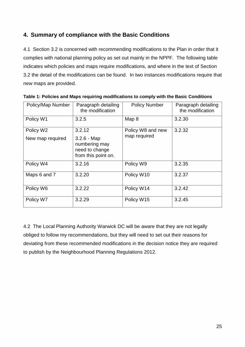
4. Summary of compliance with the Basic Conditions
4.1 Section 3.2 is concerned with recommending modifications to the Plan in order that it
complies with national planning policy as set out mainly in the NPPF. The following table
indicates which policies and maps require modifications, and where in the text of Section
3.2 the detail of the modifications can be found. In two instances modifications require that
new maps are provided.
Table 1: Policies and Maps requiring modifications to comply with the Basic Conditions
Policy/Map Number Paragraph detailing the modification
Policy Number Paragraph detailing the modification
Policy W1 3.2.5 Map 8 3.2.30
Policy W2
New map required
3.2.12
3.2.6 - Map numbering may need to change from this point on.
Policy W8 and new map required
3.2.32
Policy W4 3.2.16 Policy W9 3.2.35
Maps 6 and 7 3.2.20 Policy W10 3.2.37
Policy W6 3.2.22 Policy W14 3.2.42
Policy W7 3.2.29 Policy W15 3.2.45
4.2 The Local Planning Authority Warwick DC will be aware that they are not legally
obliged to follow my recommendations, but they will need to set out their reasons for
deviating from these recommended modifications in the decision notice they are required
to publish by the Neighbourhood Planning Regulations 2012.
26
5. The Referendum Boundary
5.1 The situation in Whitnash has been complicated by a Boundary Commission
recommendation of changes to the ward boundary, which to date has resulted in a small
extra portion of land being included in an amended parish boundary for Whitnash (Order
made by Warwick DC 30th January 2015, came into force on the 1st April 2015). Other
proposed changes are to be the subject of a further review that could result in some small
areas of the existing parish being transferred to another parish. However this is very
unlikely to happen before any future referendum on this plan, and so the provisions of the
Plan still meet the Basic Conditions in that it deals only with land within the designated
area that the Town Council is the qualifying body for.
5.2 There is no requirement for a designated area to include all of a parish, so the current
change to include an extra portion of land within the parish of Whitnash does not affect the
legal position of the plan. However there is at least one dwelling on this land now
included in the parish, but not included when the designated area was agreed as the
former parish boundary. Although people in this small addition to the parish will not be
formally covered by the Whitnash Neighbourhood Plan, it will be relevant for land and
property nearby to them, and the general town council area that they are newly part of.
5.3 In the interests of equality of opportunity for all current residents of Whitnash therefore
I recommend that the boundary of the referendum follows the revised parish
boundary (April 2015) of the Town Council. This will ensure that all residents in the
defined town council area of Whitnash are included in the democratic process.
27
Appendix 1: Typographical and other errors found in the text of the Whitnash NDP
References to pages and paragraph numbers refer to the Whitnash NDP:
Submission Version. Suggested corrections are given in bold.
Bottom of page 6: web link is broken
Page 9 para 1.19 last sentence: When a new Local Plan is adopted,…..
Page 14 Objective 8 last para, first sentence: There is also a need…. to meet the
educational needs of new residents.
Page 16 para 5.1.1 second sentence: The population has ….. century, and in the space
….. five times.
Page 16 para 5.1.1 last sentence: The existing Community Centre is in a poor condition,
and rather outdated and …. open space.
Page 30 para 5.2.17 point 2: Protecting local heritage ….
Bottom of page 40: web link does not appear to be to a relevant page.