Embed Size (px)
Citation preview
WSP STRUCTURES PTY LTD
Level 15, 28 Freshwater Place, Southbank VIC 3006 Australia
T +61 3 8327 8600 F +61 3 8327 8699
www.wspstructures.com.au
ABN 78 006 769 339
.
WHOLE OF LAND PLAN:
DRAINAGE MANAGEMENT PLAN
CAULFIELD VILLAGE
PROJECT REF: 2995
Caulfield Village:
WHOLE OF LAND PLAN:
DRAINAGE MANAGEMENT PLAN PROJECT REF: 2995
2995- Civil DMP Report 2
+
Prepared for BPG Caulfield Village Pty Ltd
Prepared by Mark Rimmington
Project Engineer Khanh Dang
Project Director Peter Hindmarch
DOCUMENT REVISION STATUS
Issue Revision Issue Date Issued By
Revised Draft P13 6th Nov 15 MR
Revised Draft P12 30th Oct 15 MR
Revised Draft P11 16th Oct t 15 MR
Disclaimer
Information in this report is current as of the issue date. Reasonable skills and care has been taken in the preparation of this report. WSP Structures Pty. Ltd.
accepts no liability for loss and damages incurred as a result of reliance placed upon its content.
The mention of any company, product or process in this report does not constitute or imply endorsement by WSP Structures Pty. Ltd.
Caulfield Village:
WHOLE OF LAND PLAN:
DRAINAGE MANAGEMENT PLAN PROJECT REF: 2995
2995- Civil DMP Report 3
TABLE OF CONTENTS
Disclaimer ................................................................................................................................................................ 2
1. INTRODUCTION ............................................................................................................................................ 4
2. PURPOSE ........................................................................................................................................................ 5
3. EXISTING CONDITIONS .............................................................................................................................. 5
4. DRAINAGE ...................................................................................................................................................... 5
4.1 Council requirements ............................................................................................................................. 5
4.2 Drainage Method and Detention System ............................................................................................ 6
4.3 Drainage Management .......................................................................................................................... 7
4.4 Water Sensitive Urban Design (WSUD) .............................................................................................. 7
4.5 Ground Water .......................................................................................................................................... 7
4.6 Upgrading of the existing drainage infrastructure .............................................................................. 8
4.7 Flood levels .............................................................................................................................................. 9
5. CONCLUSION .............................................................................................................................................. 12
Appendix A: Whole of Land Catchment Plan................................................................................................... 13
Appendix B: MUSIC Results ............................................................................................................................. 16
Appendix C: Melbourne Water Flood information Letters ............................................................................. 19
Appendix D: Legal Points of Discharge Calculations ........................................................................................ 22
Appendix E: Ground Water Correspondence .................................................................................................. 29
CAULFIELD VILLAGE:
WHOLE OF LAND PLAN:
DRAINAGE MANAGEMENT PLAN PROJECT REF: 2995
2995- Civil DMP Report 4
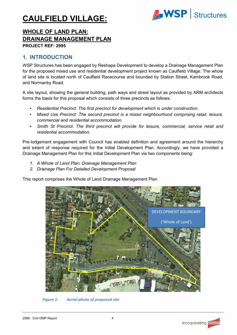
1. INTRODUCTION
WSP Structures has been engaged by Reshape Development to develop a Drainage Management Plan
for the proposed mixed use and residential development project known as Caulfield Village. The whole
of land site is located north of Caulfield Racecourse and bounded by Station Street, Kambrook Road,
and Normanby Road.
A site layout, showing the general building, path ways and street layout as provided by ARM architects
forms the basis for this proposal which consists of three precincts as follows:
• Residential Precinct: The first precinct for development which is under construction.
• Mixed Use Precinct: The second precinct is a mixed neighbourhood comprising retail, leisure,
commercial and residential accommodation.
• Smith St Precinct: The third precinct will provide for leisure, commercial, service retail and
residential accommodation.
Pre-lodgement engagement with Council has enabled definition and agreement around the hierarchy
and extent of response required for the Initial Development Plan. Accordingly, we have provided a
Drainage Management Plan for this Initial Development Plan via two components being:
1. A Whole of Land Plan: Drainage Management Plan
2. Drainage Plan For Detailed Development Proposal
This report comprises the Whole of Land Drainage Management Plan
Figure 1: Aerial photo of proposed site
DEVELOPMENT BOUNDARY
(‘Whole of Land’)
CAULFIELD VILLAGE:
WHOLE OF LAND PLAN: DRAINAGE
MANAGEMENT PLAN
PROJECT REF: 2995
2995- Civil DMP Report 5
2. PURPOSE
The purpose of this report is to provide a “high level” study of the existing authority drainage infrastructure
network for the Whole of Land development, and potential impacts on the current council drainage
infrastructure.
The report will also assess compliance with “Schedule 2 to The Priority Development Zone”. Specifically,
section 6 requires a Drainage Management Plan (DMP) that provides:
• A Drainage system of a design that ensures that the quantity of stormwater discharged from the
site is appropriately managed.
• The incorporation of the water sensitive urban design principles that address the quality of
stormwater leaving the site and entering the local drainage system.
• An outline of the ongoing management arrangements for the internal drainage and water sensitive
urban design elements.
3. EXISTING CONDITIONS
The proposed development is located just north of the Caulfield Race Course and is bounded by Station
Street, Kambrook Road, and Normanby Road. The majority of the existing site is undeveloped grassed
area which is generally used for car parking. A smaller portion of the site bounded by Station Street,
Smith Street and Normanby Road is currently an asphalted car park and Precinct 1, bounded by
Kambrook Road and Bond Street is under construction.
The total site is approximately 49,338m2 for the three precincts, which does not include the road reserves.
The site level and feature survey indicates that the approximate levels at the streets adjacent to the site
are:
• Kambrook Road falls from South at R.L.43.70 to North R.L.43.30
• Bond Street falls from South R.L.45.70 to North at R.L.43.50
• Station Street falls from the middle R.L.50.70 to the West at R.L.44.40 and to the East at
R.L.48.50
• Normanby Road falls from the South at R.L.48.50 to the North at R.L.43.50
4. DRAINAGE
The Responsible Authority for the drainage infrastructure at the proposed development is the Glen Eira
City Council (GECC).
4.1 Council requirements
The Legal Point of Discharge (LPD) of this development was discussed with GECC engineering staff, Mr
Salim Murtaza, Mr Adbul Wazeer, Mr Paul Samaratunge and Winward Civil at a meeting held on the 7th
of March 2013, at Council premises. Council has granted ‘in principle’ approval for multiple stormwater
discharge points across the development due to the scale of the development and configuration of the
existing council stormwater drainage network.

Caulfield Village:
WHOLE OF LAND PLAN:
DRAINAGE MANAGEMENT PLAN PROJECT REF: 2995
2995- Civil DMP Report 6
The engineering conditions stipulated by GECC are as follows:
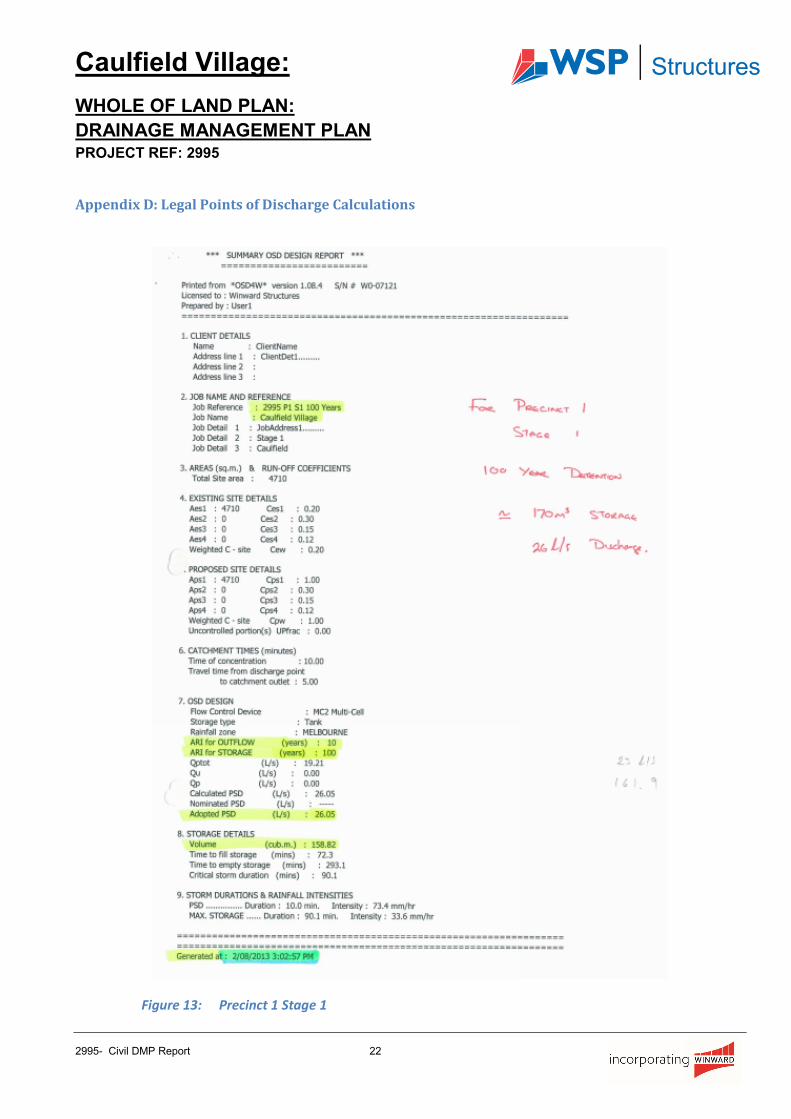
• The discharge rate from the site is to be limited to the ‘1 in 10’ year ARI.
• Detention storage volumes are to be designed for the ‘1 in 10’ year ARI.
• Time of concentration was set at 5 minutes (min) plus 1 m/s back into our site
• The rational method was to be used in calculating the existing discharge rates
• Runoff coefficients for existing grass land was given as 0.2
• The overland flow and depths are to be in accordance with Melbourne Water’s requirements
floodway safety criteria for maximum velocity of 1.5m/s, depth of 0.35m and the depth x velocity
< 0.35m2/s
• Water Sensitive Urban Design (WSUD) initiatives are to be implemented for the total
development. The Council defined the following minimum performance targets to be achieved by
WSUD initiatives:
o Total suspended Solid 80%
o Total Phosphorus 45%
o Total Nitrogen 45%
We confirm that all design work and modelling has adopted these requirements.
4.2 Drainage Method and Detention System
The total area (Whole of Land) will be developed in three phases relative to the three precincts as defined
in Section 1.
The development proposal generally assumes delivery of several multi storey buildings built over
proposed basement car parks in the first two precincts. Therefore, a run-off coefficient value of 1.0 has
been applied to calculate the discharge flow rates.
The assumed ground floor design restricts the existing overland flow path condition. Therefore the
detention systems have been designed to cater for up to ‘1 in 100’ ARI storm event.
Tanks have been designed for ‘1 in 20’ ARI storm with the remainder to be detained on the surface of
the lower basement car park, except for stage one of the residential precinct in which the tank has been
designed for a ‘1 in 100’ ARI storm.
Separate Legal Points of Discharge (LPD) and detention tanks will be applied to each stage of the
development.
The LPD discharge flow rates and the detention tank storage volumes for the whole development are
expressed in the table below.

Caulfield Village:
WHOLE OF LAND PLAN:
DRAINAGE MANAGEMENT PLAN PROJECT REF: 2995
2995- Civil DMP Report 7
Precinct Stage Discharge Rate:10 Years
(l/s)
Detention Tank Volume (m3)
Discharge location
Residential 1 26 170 Bond street via new 300ø drain (pit 9)
Residential 2 25 160 Redan Road existing 900ø via new
300ø drain (pit 2)
Residential 3 28 185 Bond street via new 300ø drain (pit 4)
Mixed use 4.5 & 6 70 445 Into the ex 675ø in Heywood St (pit 7)
Mixed use 7 & 8 64 400 Normanby Road via new 600ø across
street into the ex. 900ø (Pit 18)
Smith St 9 25 110 Into the proposed new street “The
Boulevard” drainage system (pit 20)
Smith St 10 39 160 Into the proposed new street “The
Boulevard” drainage system (pit 21)
Table 1: Discharge Rates and Detention Volumes for each stage.
4.3 Drainage Management
A Body Corporate will be formed that will be responsible for the maintenance and management of the
internal stormwater system before the stormwater discharges into council’s drainage infrastructure.
Regular maintenance activities undertaken on behalf of the Body Corporate will ensure that all internal
stormwater assets such as the pumping system, detention tanks, rainwater tanks and pits are operating
to their maximum efficiency to guarantee performance objectives are met.
4.4 Water Sensitive Urban Design (WSUD)
At conceptual design stage, yield studies have been completed and generic WSUD design principles
have been inputted into a Model for Urban Stormwater Improvement Conceptualisation (MUSIC) model
assuming the following:
• Rainwater tanks will capture runoff from building roofs for storage for reuse.
• Water reuse will be used for:
o 1. Irrigation of the garden areas
o 2. Toilet flushing in some of the buildings on site.
• Detention tanks will hold and release the rainwater at the permissible rate to the Councils drains.
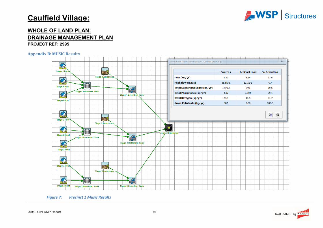
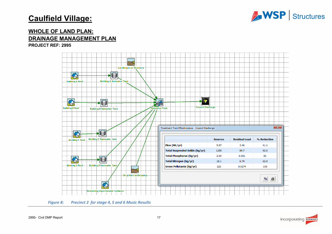
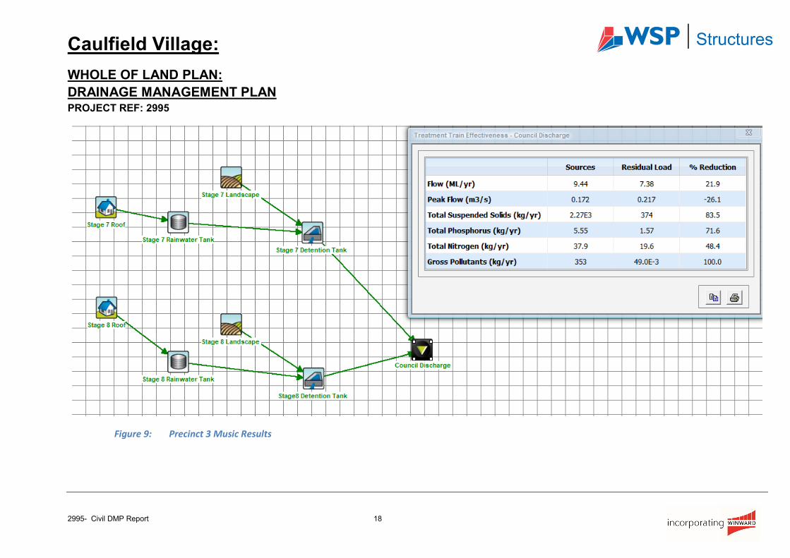
Preliminary results, attached as Appendix B, show that minimum WSUD performance targets stipulated
by Council for the Whole of Land can be achieved. The WSUD scheme and calculations will be
remodelled and submitted to Council for verification as part of each applicable development plan
application as the design develops further.
4.5 Ground Water
A supplementary geotechnical investigation report provided by Golder Associates (Ref No. 137612021-
010-L-Rev 0) advised that ground water at inflow rates of up to 2 l/s is present for each proposed precinct
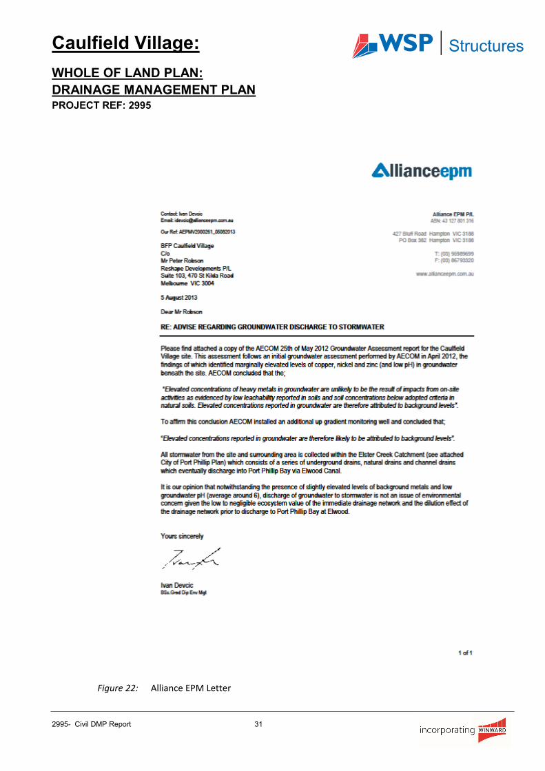
site. Alliance EPM assessed the quality of this ground water and advised that the “discharge of
groundwater to stormwater is not an issue of environmental concern”.
Caulfield Village:
WHOLE OF LAND PLAN:
DRAINAGE MANAGEMENT PLAN PROJECT REF: 2995
2995- Civil DMP Report 8
This information was submitted to Council along with a request for their approval to discharge ground
water into the Council drainage system, refer appendix E for a copy of this information.
Council gave permission to discharge the ground water from the site into the Council drainage system
subject to the flow rate being limited to a permissible flow rate nominated by Council.
Accordingly, the ground water will be collected by a number of strip drains along the perimeter walls and
agriculture drains under the basement slab which will then be directed into the detention tanks on site
prior to discharging to the Council drainage system at the permissible flow rate.
4.6 Upgrading of the existing drainage infrastructure
A full feature and level survey was carried out specifically for this development so that we could check
the capacity of the existing drainage infrastructure. The Capacity has been evaluated based on the invert
levels and pipe sizes from the relevant levels obtained from this feature survey information and site visits.
Catchment areas with a new coefficient of run-off have been used to calculate the required capacity of
the infrastructure drain, which was then compared with the existing condition. Based on the assessment
of the pipe capacities between the existing and required, some of the existing infrastructure pipes are
required to be up-graded to provide sufficient capacity for the proposed condition. For reference, the
applicable proposed catchment plan is attached as Appendix A of this report
.
Caulfield Village:
WHOLE OF LAND PLAN:
DRAINAGE MANAGEMENT PLAN PROJECT REF: 2995
2995- Civil DMP Report 9
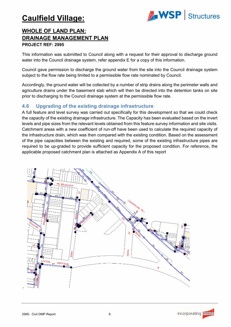
Figure 2: Existing Council Drainage Network
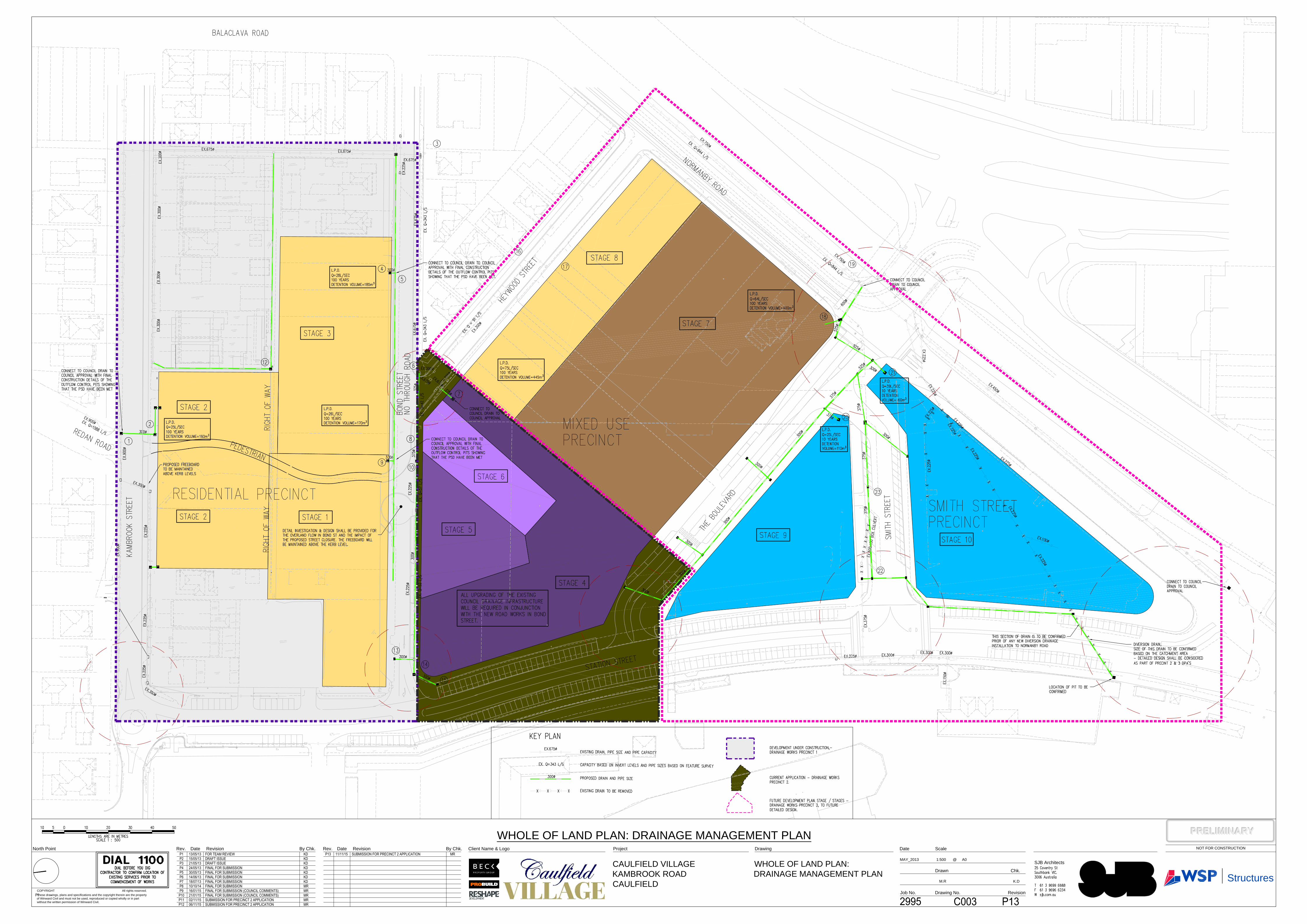
Existing drainage pipes that will require upgrade are shown on the drainage management plan being
Drawing 2995 C003: Whole of Land Plan: Drainage Management Plan indicates;
• Existing drainage
• Proposed Upgrades to existing drainage; and
• Proposed new drainage.
• Legal points of discharge
A full size drawing accompanies this report and should be read in conjunction with Table 2, which
indicates the proposed staging of existing drainage system upgrades during the construction of the
proposed development.
There are also other areas, such as new roads, that currently do not have any associated drainage
infrastructure. Therefore, proposed pipe sizes have been nominated for these drains and indicated on
the drainage management plan.
Pit Numbers Catchment Total Catchment Existing Pipe Size
Upgrade Pipe To
Upgrade To Take Place
during
14 - 10 1 1 225ø 300ø Bond Street
Upgrade
10 - 6 2 1, 2 & Stage 1 300ø 375ø Bond Street
Upgrade
6 - 5 4 1, 2, 3, 4, Stage 1
& Stage 5 675ø - -
5 - 3 5 1, 2, 3, 4, 5,
Stages 1, Stage 2 & Stage 5
675ø - -
22 - 23 7 7 375ø &
600 x 150 Box Culvert
450ø During Smith
Street Upgrade
Table 2: Showing The Existing Drainage Networks That Will Require Upgrading.
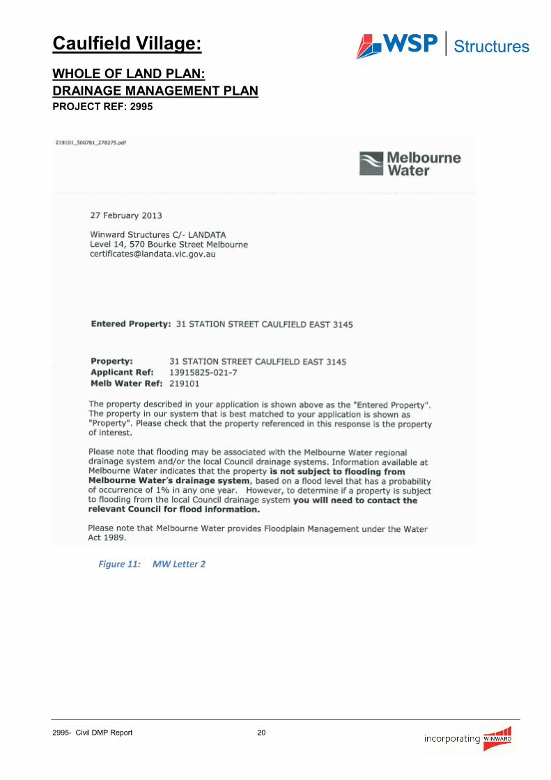
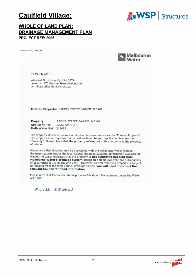
4.7 Flood levels
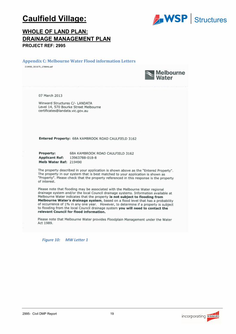
Melbourne Water has confirmed that the development area is not subject to any flooding from Melbourne
Water drainage system. (Refer letters as per Appendix C).
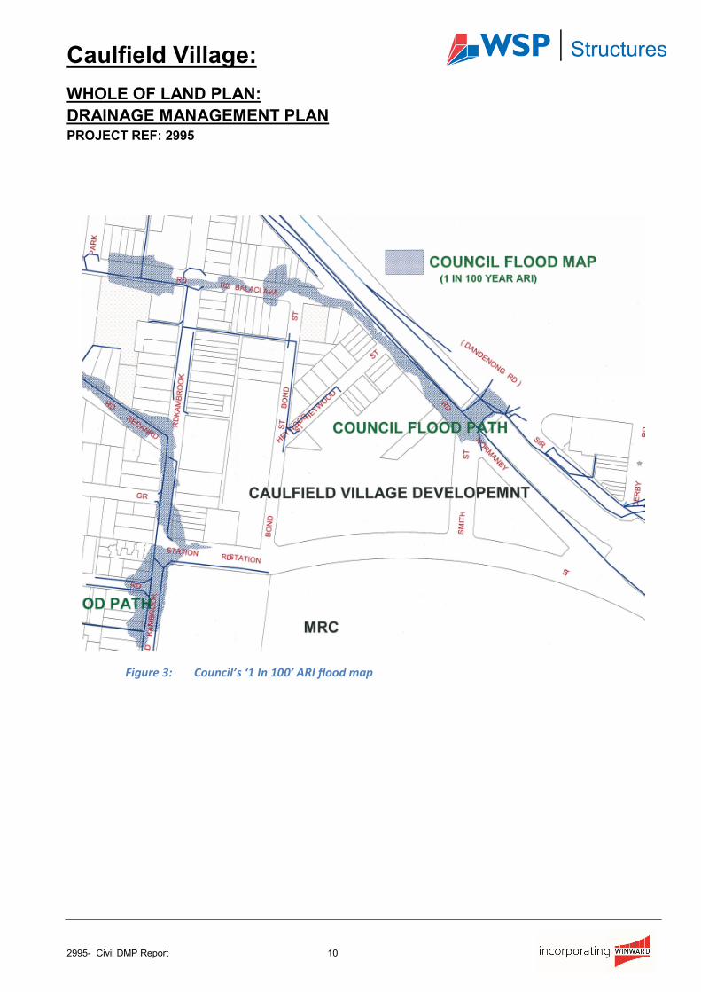
GECC has confirmed that there are certain areas subject to inundation from the local overland flow on
the road reserve in larger storm events, (refer to Fig. 3). The plan indicates the affected areas are along
Kambrook Road and Redan Road on the western side of the Residential Precinct.
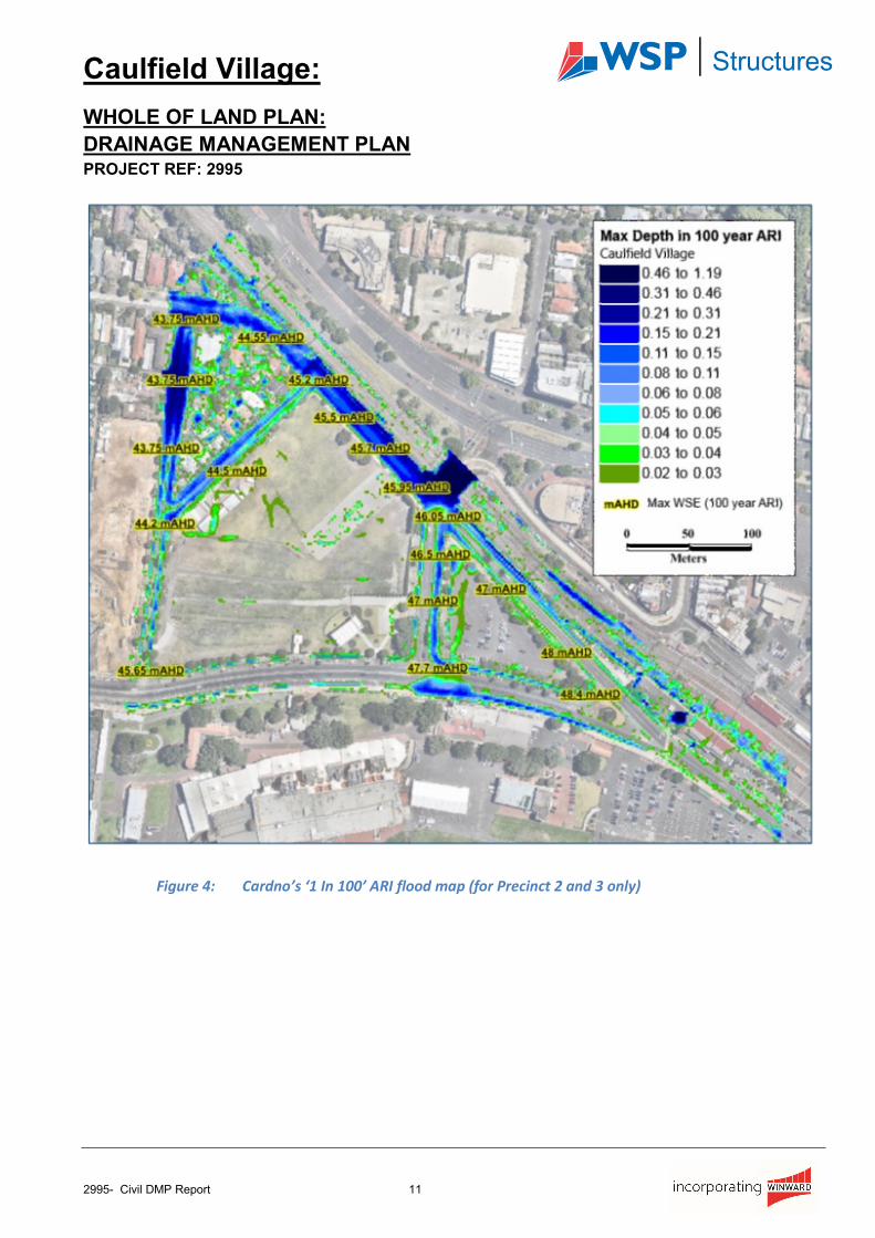
As discussed in the Cardno’s Hydraulic Report CG150215 Cardno have carried out an additional flood
map for precinct 2 & 3 in which we have copied the flood map and flood levels from this report shown in
figure 4. As stated in Cardno’s report “ As per standard engineering practice, the finished floor level of
the buildings is to be a minimum of 300mm above the 1 in 100 year ARI flood level”
Caulfield Village:
WHOLE OF LAND PLAN:
DRAINAGE MANAGEMENT PLAN PROJECT REF: 2995
2995- Civil DMP Report 10
Figure 3: Council’s ‘1 In 100’ ARI flood map
Caulfield Village:
WHOLE OF LAND PLAN:
DRAINAGE MANAGEMENT PLAN PROJECT REF: 2995
2995- Civil DMP Report 11
Figure 4: Cardno’s ‘1 In 100’ ARI flood map (for Precinct 2 and 3 only)
Caulfield Village:
WHOLE OF LAND PLAN:
DRAINAGE MANAGEMENT PLAN PROJECT REF: 2995
2995- Civil DMP Report 12
5. CONCLUSION
This report and appendices provides a conceptual design outline for the ongoing management
arrangements for the internal drainage and Water Sensitive Urban Design elements for the Whole of
Land plan. Details will be reviewed and updated accordingly as the design develops further. These details
will be addressed in the applicable Development Plan.
Accordingly, based on the results of these investigations, the proposed development meets the
requirements as stipulated in Section 6 in Schedule 2 of The Priority Development Zone for the following
reasons:
• The drainage system design ensures that the quantity of stormwater discharged from the site is
appropriately managed.
• The proposed Water Sensitive Urban Design (WSUD) measures to be incorporated into the
drainage design will ensure that the quality of stormwater discharge into Council’s drainage
infrastructure will comply with the council’s minimum WSUD performance targets.
• Following evaluation of the existing drainage infrastructure against available information, the DMP
demonstrates that proposed upgrades should have sufficient capacity to meet Council’s
requirements.
If further information is required, please feel free to contact the author.

Caulfield Village:
WHOLE OF LAND PLAN:
DRAINAGE MANAGEMENT PLAN PROJECT REF: 2995
2995- Civil DMP Report 13
Appendix A: Whole of Land Catchment Plan
Figure 5: Whole of Land Catchment Plan
Caulfield Village:
WHOLE OF LAND PLAN:
DRAINAGE MANAGEMENT PLAN PROJECT REF: 2995
2995- Civil DMP Report 14
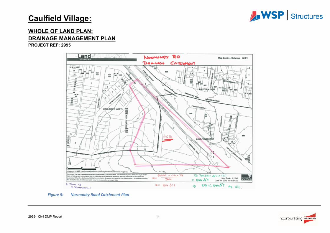
Figure 5: Normanby Road Catchment Plan
Caulfield Village:
WHOLE OF LAND PLAN:
DRAINAGE MANAGEMENT PLAN PROJECT REF: 2995
2995- Civil DMP Report 15
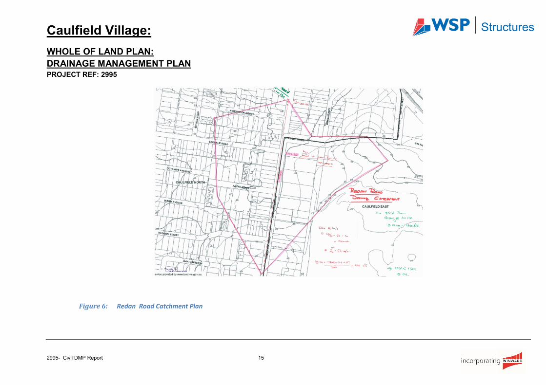
Figure 6: Redan Road Catchment Plan
Caulfield Village:
WHOLE OF LAND PLAN:
DRAINAGE MANAGEMENT PLAN PROJECT REF: 2995
2995- Civil DMP Report 16
Appendix B: MUSIC Results
Figure 7: Precinct 1 Music Results
Caulfield Village:
WHOLE OF LAND PLAN:
DRAINAGE MANAGEMENT PLAN PROJECT REF: 2995
2995- Civil DMP Report 17
Figure 8: Precinct 2 for stage 4, 5 and 6 Music Results
Caulfield Village:
WHOLE OF LAND PLAN:
DRAINAGE MANAGEMENT PLAN PROJECT REF: 2995
2995- Civil DMP Report 18
Figure 9: Precinct 3 Music Results
Caulfield Village:
WHOLE OF LAND PLAN:
DRAINAGE MANAGEMENT PLAN PROJECT REF: 2995
2995- Civil DMP Report 19
Appendix C: Melbourne Water Flood information Letters
Figure 10: MW Letter 1
Caulfield Village:
WHOLE OF LAND PLAN:
DRAINAGE MANAGEMENT PLAN PROJECT REF: 2995
2995- Civil DMP Report 20
Figure 11: MW Letter 2
Caulfield Village:
WHOLE OF LAND PLAN:
DRAINAGE MANAGEMENT PLAN PROJECT REF: 2995
2995- Civil DMP Report 21
Figure 12: MW Letter 3
Caulfield Village:
WHOLE OF LAND PLAN:
DRAINAGE MANAGEMENT PLAN PROJECT REF: 2995
2995- Civil DMP Report 22
Appendix D: Legal Points of Discharge Calculations
Figure 13: Precinct 1 Stage 1
Caulfield Village:
WHOLE OF LAND PLAN:
DRAINAGE MANAGEMENT PLAN PROJECT REF: 2995
2995- Civil DMP Report 23
Figure 14: Precinct 1 Stage 2
Caulfield Village:
WHOLE OF LAND PLAN:
DRAINAGE MANAGEMENT PLAN PROJECT REF: 2995
2995- Civil DMP Report 24
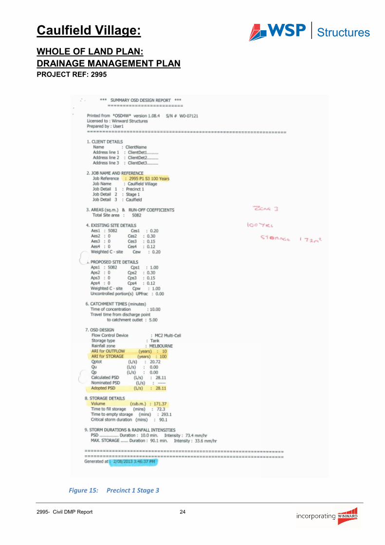
Figure 15: Precinct 1 Stage 3
Caulfield Village:
WHOLE OF LAND PLAN:
DRAINAGE MANAGEMENT PLAN PROJECT REF: 2995
2995- Civil DMP Report 25
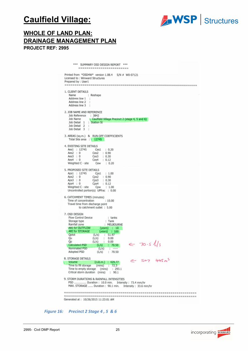
Figure 16: Precinct 2 Stage 4 , 5 & 6

Caulfield Village:
WHOLE OF LAND PLAN:
DRAINAGE MANAGEMENT PLAN PROJECT REF: 2995
2995- Civil DMP Report 26
Figure 17: Precinct 2 Stage 7 & 8

Caulfield Village:
WHOLE OF LAND PLAN:
DRAINAGE MANAGEMENT PLAN PROJECT REF: 2995
2995- Civil DMP Report 27
Figure 18: Precinct 3 Stage 9
Caulfield Village:
WHOLE OF LAND PLAN:
DRAINAGE MANAGEMENT PLAN PROJECT REF: 2995
2995- Civil DMP Report 28
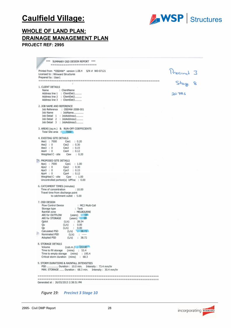
Figure 19: Precinct 3 Stage 10
Caulfield Village:
WHOLE OF LAND PLAN:
DRAINAGE MANAGEMENT PLAN PROJECT REF: 2995
2995- Civil DMP Report 29
Appendix E: Ground Water Correspondence
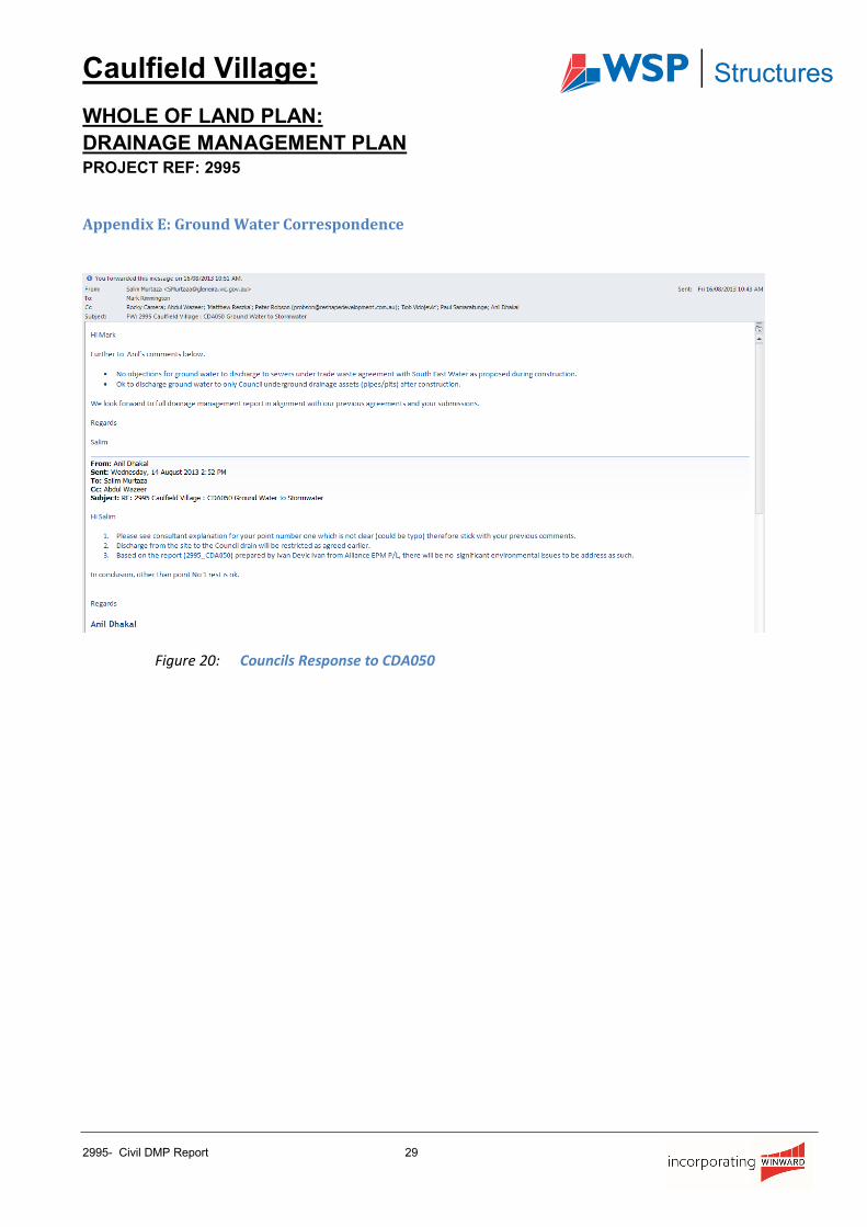
Figure 20: Councils Response to CDA050
Caulfield Village:
WHOLE OF LAND PLAN:
DRAINAGE MANAGEMENT PLAN PROJECT REF: 2995
2995- Civil DMP Report 30
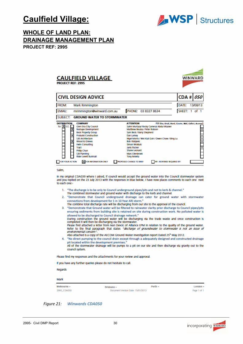
Figure 21: Winwards CDA050
Caulfield Village:
WHOLE OF LAND PLAN:
DRAINAGE MANAGEMENT PLAN PROJECT REF: 2995
2995- Civil DMP Report 31
Figure 22: Alliance EPM Letter
UNCLASSIFIEDPIT
DRAINAGEPIT
TRAMWAYPOLE
TRAMWAY
POLE
TRAMWAYPOLE
TRAMWAYPOLE
TRAMWAYPOLE
TRAMWAYPOLE
TRAMWAYPOLE
TRAMWAYPOLES
TRAMWAYPOLE
CONSTRUCTIONSITE
OPEN LAND(DERELICT)
CAR PORTSLOPINGG.I ROOF
SLOPINGG.I ROOF
SLOPINGG.I ROOF
PITCHEDTILE ROOF
GI SHEDS/
OUTBUILDINGS
GI SHEDS/
OUTBUILDINGS
GI SHEDS/
OUTBUILDINGS
GI SHEDS/
OUTBUILDINGS
GI SHED
GRASSEDYARD
GRASSEDYARD
GI SHED
GI SHED
GI SHED
GI SHED
GI SHED
GI SHED
BRICK BUILDING
PITCHED G.I ROOF
BRICK BUILDING
PITCHED G.I ROOF
GRASSEDYARD
GRASSEDYARD
GRASSEDYARD
GRASSEDYARD
GRASSEDYARD
GRASSEDYARD
GRASSEDYARD
GRASSEDYARD
UNCLASSIFIEDPIT
TRAMWAYPOLE
TRAMWAYPOLE
TRAMWAYPOLES
ROLL
ERDO
OR
FIBROSHED
GRASSEDYARD
SHED
SHED
COURTYARD
COURTYARD
COURTYARD
COURTYARD
BINSTORE
TRAMWAY &
LIGHT POLE
SHELTER
DRAINAGE PIT
DRAINAGE PT
UNCLASSIFIED
PIT
SIDE ENTRY PIT
DR
AIN
AGE
PIT
DRAINAGE PIT
43.7
1
43.88
44.1
944
.15
44.09
SIGN
SIGN
SIGN
45.26
SIDEENTRYPITS
Bore
hole
45.43
48.02CL
45.90
45.41
45.55
45.67
45.71
45.36
45.37
45.34
45.25
45.13
45.75
44.59
44.61
45.70
45.66
44.33
48.71
45.47
46.00
GRATED PIT
SID
E EN
TRY
PIT
GRATED PITS
SIDE ENTRY PIT
GRATED PIT
SID
E EN
TRY
PIT
50.23
44.26INV
SID
E EN
TRY
PIT
SEWERPIT
SEWERPIT
SEWERPITSEWER
PIT
50.96
RAIL
50.89
RAIL
50.89
RAIL
GASMARKERPOST
GASMARKERPOST
GASMARKERPOST
50.84
RAIL
50.91
RAIL
50.89
RAIL
50.98
RAIL
50.98
RAIL
Client Name & Logo Project
All rights reserved.COPYRIGHT
Rev. Date Revision By Chk.North Point Drawing Date Scale
Drawn Chk.
Job No. Drawing No. Revision
SJB Architects
2995
Rev. Date Revision By Chk.
These drawings, plans and specifications and the copyright therein are the propertyof Winward Civil and must not be used, reproduced or copied wholly or in partwithout the written permission of Winward Civil.
StructuresP1 -
NOT FOR CONSTRUCTION
PRELIMINARYPRELIMINARY
C003
MAY_2013
M.R K.D
P13
WHOLE OF LAND PLAN:DRAINAGE MANAGEMENT PLAN
A0@1:500
WHOLE OF LAND PLAN: DRAINAGE MANAGEMENT PLANP1 13/05/13 FOR TEAM REVIEW KDP2 15/05/13 DRAFT ISSUE KDP3 21/05/13 DRAFT ISSUE KDP4 24/05/13 FINAL FOR SUBMISSION KDP5 30/05/13 FINAL FOR SUBMISSION KDP6 14/06/13 FINAL FOR SUBMISSION KDP7 18/07/13 FINAL FOR SUBMISSION KD
CAULFIELD VILLAGEKAMBROOK ROADCAULFIELDP8 10/10/14 FINAL FOR SUBMISSION MR
P9 16/01/15 FINAL FOR SUBMISSION (COUNCIL COMMENTS) MRP10 21/01/15 FINAL FOR SUBMISSION (COUNCIL COMMENTS) MRP11 02/11/15 SUBMISSION FOR PRECINCT 2 APPLICATION MRP12 06/11/15 SUBMISSION FOR PRECINCT 2 APPLICATION MR
P13 11/11/15 SUBMISSION FOR PRECINCT 2 APPLICATION MR