Embed Size (px)
Citation preview
WIGSLEY AIRFIELD WIND TURBINE
SUPPORTING STATEMENT
May 2013


Prepared By:
Arcus Consultancy Services
Suite 1C Swinegate Court East
York North Yorkshire
YO1 8AJ
T +44 (0)1904 715 470 l E [email protected] w www.arcusconsulting.co.uk
Registered in England & Wales No. 5644976

Supporting Statement Wigsley Airfield Wind Turbine
Arcus Consultancy Services Ltd Page i May 2013
TABLE OF CONTENTS
1 INTRODUCTION ........................................................................................................ 1
1.1 Overview......................................................................................................... 1
1.2 The Application Site........................................................................................ 1
1.2.1 Site Identification ............................................................................................... 1
1.3 Project Description ......................................................................................... 2
1.3.1 Wind Turbine ..................................................................................................... 2
1.3.2 Turbine Foundations ........................................................................................... 3
1.3.3 Transformer Housing .......................................................................................... 3
1.3.4 Crane Hardstanding ............................................................................................ 3
1.3.5 Access Tracks .................................................................................................... 3
1.4 Wind Resources .............................................................................................. 3
1.5 Grid Connection .............................................................................................. 3
2 PLANNING POLICY FRAMEWORK ............................................................................. 4
2.1 National Planning Policy Framework ............................................................. 5
2.1.1 Introduction ...................................................................................................... 5
2.1.2 Renewable Energy ............................................................................................. 6
2.1.3 Plan Making ....................................................................................................... 6
2.1.4 Decision-taking .................................................................................................. 7
2.1.5 Weight Attached to Development Plan Policies under the NPPF................................ 7
2.2 Development Plan Policies Relating to the Principle of the Development..... 7
2.2.1 Core Strategy .................................................................................................... 7
2.2.2 Local Plan ......................................................................................................... 8
2.2.3 Commentary ...................................................................................................... 8
2.3 Site Specific Development Plan Policies......................................................... 9
2.3.1 Core Strategy .................................................................................................... 9
2.3.2 Local Plan ......................................................................................................... 9
2.3.3 Commentary ...................................................................................................... 9
2.4 Other Development Plan Policies Relevant to the Development ................. 11
2.4.1 Landscape and Visual ........................................................................................ 11
2.4.2 Ecology and Ornithology .................................................................................... 14
2.4.3 Cultural Heritage ............................................................................................... 14
2.4.4 Hydrology and Flood Risk ................................................................................... 16
2.4.5 Residential Amenity ........................................................................................... 19
2.4.6 Public Rights of Way .......................................................................................... 21
2.4.7 Access ............................................................................................................. 22
2.4.8 Land Use .......................................................................................................... 23
Supporting Statement Wigsley Airfield Wind Turbine
Page ii Arcus Consultancy Services Ltd May 2013
2.4.9 Air Quality ........................................................................................................ 24
2.4.10 Aviation ........................................................................................................... 24
2.4.11 Climate Change................................................................................................. 25
2.4.12 Summary of Assessment against Development Plan .............................................. 26
2.5 Material Considerations................................................................................ 27
2.5.1 Strategic Environmental Assessment of the Revocation of the East Midlands Regional Strategy Post Adoption Statement (2013) ............................................................ 28
2.5.2 Newark and Sherwood Allocations and Development Management Development Plan Document - Publication (2012) ........................................................................... 28
2.5.3 Supplementary Planning Guidance – Wind Energy 1999 ......................................... 29
2.5.4 Low Carbon Energy Opportunities and Heat Mapping for Local Planning Areas across the East Midlands: Final Report (2011) ................................................................ 30
2.5.5 Planning for Renewable Energy a Companion Guide to PPS 22 ............................... 31
2.5.6 Energy and Climate Change Policy ...................................................................... 31
2.5.7 Summary of Material Considerations .................................................................... 33
3 CONCLUSIONS ......................................................................................................... 34
APPENDICES
APPENDIX 1 – Landscape and Visual Appraisal
APPENDIX 2 – Ecology and Ornithology Appraisal
APPENDIX 3 – Archaeology and Cultural Heritage Statement
APPENDIX 4 - Noise Assessment
APPENDIX 5 – Flood Risk Assessment
APPENDIX 6 – Bridleway Diversion
APPENDIX 7 – Aviation Consultation
DRAWINGS
DRAWING 001 - Site Location
DRAWING 002 - Site Layout Block Plan
DRAWING 003 - Typical Turbine Elevation
DRAWING 004 - Other Site Infrastructure
FIGURES
FIGURE A1.1 – Landscape Study Area
FIGURE A1.2 - Blade Tip Zone of Theoretical Visibility (ZTV) with Viewpoints (15 km).
FIGURE A1.3 – Landscape Character Types
FIGURE A1.4 – Landscape Designations
Supporting Statement Wigsley Airfield Wind Turbine
Arcus Consultancy Services Ltd Page iii May 2013
FIGURE A1.5a – Wireline from Viewpoint 1 – Spalford, Eagle Road opposite entrance to Windmill Farm
FIGURE A1.5b – Photomontage from Viewpoint 1 – Spalford, Eagle Road opposite entrance to Windmill Farm
FIGURE A1.6a - Wireline from Viewpoint 2 – Minor Road south of Wigsley
FIGURE A1.6b – Photomontage from Viewpoint 2 – Minor Road south of Wigsley
FIGURE A1.7a - Wireline from Viewpoint 3 – Moor Lane at entrance to Birklands Farm
FIGURE A1.7b – Photomontage from Viewpoint 3 – Moor Lane at entrance to Birklands Farm
FIGURE A1.8a - Wireline from Viewpoint 4 – A1133 south of South Clifton
FIGURE A1.8b - Photomontage from Viewpoint 4 – A1133 south of South Clifton
FIGURE A1.9a - Wireline from Viewpoint 5 – South Clifton on footpath south of Village
FIGURE A1.9b - Photomontage from Viewpoint 5 – South Clifton on footpath south of Village
FIGURE A1.10 - Wireline from Viewpoint 6 – Eagle on footpath near All Saints Church
FIGURE A1.11 - Wireline from Viewpoint 7 – Footpath by Doddington Hall
FIGURE A1.12 – Cumulative Sites Location Map (15 km).
FIGURE A2.1 – Phase I Ecology Map
FIGURE A3.1 – Core Archaeological Study Area
FIGURE A3.2 – Heritage features within 5km
FIGURE A4.1 – Noise Contour Plot

Supporting Statement Wigsley Airfield Wind Turbine
Arcus Consultancy Services Ltd Page 1 May 2013
1 INTRODUCTION
1.1 Overview
Arcus Consultancy Services Ltd (‘Arcus’, ‘the Applicant’) seek permission for the erection of a single, medium-scale wind turbine on the old Wigsley Airfield site in Nottinghamshire. The location of the site is shown in Planning Drawing 001.
Arcus have compiled this Supporting Statement to accompany the planning application submitted to Newark and Sherwood District Council (‘NSDC’) for the erection of the single wind turbine (‘the Development’). The installed capacity of the Development will be up to 500 kW and will generate electricity for 25 years, after which it will be removed.
1.2 The Application Site
The Application Site lies approximately 800 m northeast of Spalford and 1.2 km southwest of Wigsley in Nottinghamshire as illustrated in Drawing 001. The proposed turbine lies at an elevation of approximately 8 m above ordnance datum (AOD).
The Application Site and surrounding area comprises an old RAF airfield which is currently used for outdoor pig rearing. There is a large block of woodland, Wigsley Wood, approximately 410 m to the north.
The Application Site will be accessed off Wigsley Road making use of an existing access track/ former runway over land within the control of the Applicant. No new access tracks will need to be constructed given the proposed location of the turbine just off the former runway.
The layout of the Development is shown in Drawing 002 accompanying the planning application.
1.2.1 Site Identification
The possibility of installing a wind turbine at the Application Site was assessed as part of feasibility work carried out between 2011 and 2013. The feasibility work carried out assessed technical, environmental and aesthetic issues relating to landscape and visual impacts.
In technical terms, a number of factors were initially considered which included:
• Existing infrastructure – local roads, rights of way, overhead or underground services, etc., that pass in close proximity to the Application Site, or through it, that require to be protected or safeguarded during construction and in the unlikely event of a structural failure during operation;
• Access – the means of accessing the Application Site via the local road network can influence the size of turbine that can be accommodated;
• Grid connection capacity and location – the means of carrying the power off-site and the electrical power that can be accommodated by the grid network in the area; and
• Proximity to housing – to safeguard the amenity of nearby properties from the potentially intrusive effects of the turbine, both visually and noise related.
In environmental terms, the capacity of the land available for development may be further affected by areas of sensitivity, which may limit or even preclude development. Issues considered at the Application site included:
• Ecology and ornithology – valuable habitats and protected species of plants, animals and birds that may be present on the site, including the flight path of birds and bats;
• Cultural heritage – archaeological features that may be present on the site; and • Other features – field boundaries, drainage ditches / watercourses.
Supporting Statement Wigsley Airfield Wind Turbine
Page 2 Arcus Consultancy Services Ltd May 2013
In landscape and visual terms, the capacity of the land available for development relates to its ability to accommodate the wind turbine without creating unacceptable effects on the physical fabric of the site itself, on the character of the surrounding landscape and on views from surrounding areas. A number of landscape and visual design objectives were set out to guide the design process, as follows:
• Turbine position should respond to prevailing wind resource; • Turbine position should relate to landform features, contours and boundaries in order
to provide a landscape basis for a wind energy development; • The Development should respond to the scale of the landform and be appropriate for
the overall landscape scale; • The Development should respond to the local landscape context, so that when it is
seen, it forms a positive image, with a clear rationale for the turbines position, particularly from key local receptors (e.g. surrounding minor roads, footpath users, isolated properties);
• The turbines should be sited as far from local residential properties as practicable to seek to minimise environmental effects on the wider landscape; and
• The overall visual intrusiveness of the Development should be minimised.
This feasibility work concluded that the land under the control of the Applicant had the potential to accommodate a single medium scale wind turbine, of the size proposed in this application, and a Screening Opinion request was submitted to NSDC in January 2011. Confirmation was received from NSDC, dated 25th January 2011, that the Development was considered not to constitute EIA development.
The outcome of the feasibility study was that the most suitable location for the turbine was adjacent to the old runway at an elevation of approximately 8 m above ordnance datum, as shown in Planning Drawings 001 and 002. The turbine has been sited in this location to make use of existing access roads and to minimise disruption to the pig farm. The turbine is also located away from field boundaries in line with Natural England guidance for the protection of bats, which requires a separation distance of 50 m to the closest part of the turbine. In order to effectively consider ecological effects Ecological Walkover and Ornithology Surveys were carried out at the Application Site and surrounds, as discussed in Section 2.3 and Appendix 2.
The proposed turbine is located approximately 600 m from the closest residential property. Following a noise assessment, as discussed in Section 2.6.1 and Appendix 4, no noise issues are anticipated from the operation of the turbine.
Given all of the above, the proposed location of the turbine is considered to be the optimum location within the land under control of the Applicant.
1.3 Project Description
The Application will consist of a single wind turbine and associated infrastructure. It should be noted that no new access tracks will be required nor will a laydown area or crane hardstanding pad be needed as existing infrastructure (former airfield runway) will be utilised for these purposes. Descriptions of each component of the Development are found below. The layout of the Development within the Application Site is shown in Drawing 002.
1.3.1 Wind Turbine
The Applicant has identified a candidate turbine; the EWT500. The key statistics of which are:
• Hub height: 50 m; • Rotor diameter: 54 m; • Maximum tip height: 77 m;
Supporting Statement Wigsley Airfield Wind Turbine
Arcus Consultancy Services Ltd Page 3 May 2013
• Number of blades: 3; and, • Output rating: 500 kW.
The blades will be manufactured from glass fibre reinforced plastic (epoxy resin) and the hub from steel. The nacelle houses the gearbox and generator. Subject to agreement with NSDC, the finish and colour of the turbine is likely to be semi-matt and pale grey. Turbine elevations are illustrated in Drawing 003.
1.3.2 Turbine Foundations
The form of the wind turbine foundations will depend on site geology, turbine location, and the turbine manufacturer’s ground-stiffness foundation criteria. Preliminary site survey work will be undertaken prior to construction to determine the condition of the ground and which type of turbine foundations will be suitable on site. The foundations will typically take the form of reinforced concrete foundations which will include a circular steel support plinth to suit the base profile of the tower section. The turbine foundation will typically be approximately 11 m x 11 m and will be typically overlain by crushed stone topped with fine stone. A typical turbine foundation is illustrated in Drawing 004.
1.3.3 Transformer Housing
Depending upon the model of turbine the transformer will either be located within the tower or in a small housing close to the base of the turbine. The housing will have dimensions of approximately 2 m x 3 m x 2 m. A typical transformer housing is illustrated in Drawing 004.
1.3.4 Crane Hardstanding
An area of hard-standing will be required in order to provide a stable base on which to lay down the turbine components ready for assembly and erection and to site the crane necessary to lift the tower sections, the nacelle and rotor components into place. It is considered that the existing runway hardstanding would provide a suitable lay down area and crane pad and no further construction or upgrading is considered necessary. Typically an area of 40 m x 20 m is required and this has indicatively been shown in Drawing 002.
1.3.5 Access Tracks
The existing farm track/ former airfield runway off Wigsley Road will be used to access the location where the turbine is proposed to be sited. It is considered that this track is adequate and will not require widening or strengthening to safely accommodate delivery and construction vehicles. No new access tracks will need to be constructed. No hedgerow or dry-stone walling will need to be removed in order to access the site.
1.4 Wind Resources
The NOABL wind speed database shows the site to have wind speeds of up to 6.3 ms-1 at 45 m above ground level. The area around the site is largely open with some small woodland areas to the north. The site is largely flat and wind conditions at the site are unlikely to be affected by turbulence occurring as a result of topography or built up areas / features.
1.5 Grid Connection
The Development is located approximately 750 m from the nearest overhead 11 kilovolt (‘kV’) transmission line and 700 m from the nearest underground 11 kV transmission line. Connection to the grid at either of these locations is not considered likely to cause any adverse environmental impacts. The grid connection will be made under a separate
Supporting Statement Wigsley Airfield Wind Turbine
Page 4 Arcus Consultancy Services Ltd May 2013
planning application but it is likely that all cabling will be routed underground wherever possible.
2 PLANNING POLICY FRAMEWORK
This section of the Supporting Statement reviews the key Development Plan policies and guidance which cover the site and relate specifically to the Development. The aim of the section is to establish the land use implications of the Development considering its compliance with the Development Plan and identifying other material considerations to be taken into cognisance during the determination process, including national planning and energy policies which are looked upon as key material considerations to the Development.
The Planning and Compulsory Purchase Act 2004, section 38(6) states that:
“In dealing with such an application the authority shall have regard to the provisions of the development plan, so far as material to the application, and to any other material considerations.”
Based on the above, the process for determining a planning application can therefore be defined as:
• Identification and consideration of the Key Provisions within the Development Plan relevant to the application;
• Identification and consideration of the relevant Material Considerations; and • Conclusions on whether Planning Consent is justified.
The current Development Plan for NSDC comprises the following:
• Newark and Sherwood Council Local Plan (‘The Local Plan’)1
• Newark and Sherwood Council Core Strategy (NSCCS); and
2
The East Midlands Regional Plan (EMRP) was published as the Regional Spatial Strategy in March 2009 and provided a wide ranging development strategy for the East Midlands until 12th April 2013 when it was formally revoked, and ceased to form part of the Development Plan. The evidence base for the preparation of the EMRP however remains a material planning consideration.
.
The development planning system in England is currently in a transitional period. The Planning and Compulsory Purchase Act 2004, which forms an amendment to the Town and Country Planning Act 1990, requires that Local Plans are replaced with Local Development Frameworks (‘LDFs’).
The Local Plan was prepared by NSDC and adopted in 1999, and the ‘Saved’ policies of the Local Plan remain part of the Development Plan. However, the ‘Saved’ policies of the Local Plan will be replaced with the adoption of the Allocations and Development Management Development Plan Document3
NSDC adopted the Core Strategy of the LDF in March 2011, which now forms part of the Development Plan. However, the Core Strategy does not fully replace the Local Plan, and there are policies from the Local Plan that have been “saved”. As such, the Core Strategy
(‘the Allocation and Management DPD’) in 2013.
1 Newark and Sherwood District Council, 1999, Newark and Sherwood District Council Local Plan, “Newark and Sherwood District Council Local Plan”, Newark and Sherwood District Council 2 Newark and Sherwood District Council,2011, Newark and Sherwood District Council Local Development Framework Core Strategy Development Plan Document, “Newark and Sherwood District Council Local Development Framework Core Strategy Development Plan Document”, Newark and Sherwood District Council 3 Newark and Sherwood District Council, 2012, “Newark and Sherwood & Development Management Development Plan Document”, Newark and Sherwood District Council
Supporting Statement Wigsley Airfield Wind Turbine
Arcus Consultancy Services Ltd Page 5 May 2013
and the ‘Saved’ Policies of the Local Plan (at present) are both part of the Development Plan and should be read in conjunction.
In addition to the Development Plans, the National Planning Policy Framework4 (the ‘NPPF’) sets out the current Government policy on renewable energy and provides guidance to Local Authorities. Whilst the NPPF has replaced all of the previous Planning Policy Guidance and Planning Policy Statements, it is understood from the Department of Communities and Local Government that ‘Planning for Renewable Energy a Companion Guide to PPS22’5
The NPPF and the Companion Guide will thus form a material consideration in the determination of this application.
(‘the Companion Guide’) is still an extant document.
2.1 National Planning Policy Framework
2.1.1 Introduction
The NPPF sets out Central Government’s planning policies for England and how these are to be applied. It aims to provide a framework within which local people and their Councils can produce their own distinctive local and neighbourhood plans to reflect their communities. The NPPF reiterates that applications for planning permission must be determined in accordance with the development plan unless material considerations indicate otherwise. It also identifies the NPPF as a material consideration when making decisions on planning applications.
The NPPF sets out the economic, environmental and social planning policies for England. Central to these main themes is a presumption in favour of sustainable development, and that development should be planned positively. In achieving sustainable development, planning is identified as performing economic, social and environmental roles. The environmental role is stated, in part, to:
“mitigate and adapt to climate change including moving to a low carbon economy”
The NPPF is clear that the presumption in favour of sustainable development should be seen as “a golden thread” running through all individual proposals wherever possible. In respect of making decisions on planning applications, unless material considerations indicate otherwise, this means (paragraph 14):
• “approving development proposals that accord with the development plan without delay; and
• where the development plan is absent, silent or relevant policies are out of date, granting permission unless:
− any adverse impacts of doing so would significantly and demonstrably outweigh the benefits, when assessed against the policies in this Framework taken as a whole; or
− specific policies in this Framework indicate development should be restricted.”
The NPPF provides guidance on a number of relevant environmental issues in achieving sustainable development covering transport, flood risk, landscape, biodiversity, pollution, health and quality of life issues including noise, the historic environment and the consideration of structures interfering with broadcast and telecommunications. Relevant guidance is also provided on renewable energy considerations, which are detailed below.
4 Department of Communities and Local Government, “National Planning Policy Framework”, March 2012. Available on line http://www.communities.gov.uk/documents/planningandbuilding/pdf/2116950.pdf 5 Office of the Deputy Prime Minster, “Planning for Renewable Energy A Companion Guide to PPS22”, 2004, HMSO
Supporting Statement Wigsley Airfield Wind Turbine
Page 6 Arcus Consultancy Services Ltd May 2013
2.1.2 Renewable Energy
The ‘Core Planning Principles’ (paragraph 17) include the following, with respect to renewable energy:
• “support the transition to a low carbon future in a changing climate..., and encourage the use of renewable resources (for example, by the development of renewable energy);”
The NPPF is clear that planning has a key role in supporting renewable energy, and identifies this is central to the economic, social and environmental dimensions of sustainable development. Local Planning Authorities (LPAs) recognise the role of all communities to energy generation from renewable sources, in order to increase the use and supply of renewable energy. They should also (paragraph 97):
• “have a positive strategy to promote energy from renewable and low carbon sources; • design their policies to maximise renewable and low carbon energy development
while ensuring that adverse impacts are addressed satisfactorily, including cumulative landscape and visual impacts;
• consider identifying suitable areas for renewable and low carbon energy sources, and supporting infrastructure, where this would help secure the development of such sources”
The NPPF is clear that there is no requirement for applicants to demonstrate need for renewable energy development (paragraph 98), stating that LPAs should:
“not require applicants for energy development to demonstrate the overall need for renewable or low carbon energy and also recognise that even small-scale projects provide a valuable contribution to cutting greenhouse gas emissions”.
2.1.3 Plan Mak ing
The NPPF identified that ‘Local Plans’ are the key to delivering sustainable development, and that they must be prepared to be consistent with the NPPF. They should set out “strategic priorities” for an area, including the provision of infrastructure for energy. Paragraph 157 states that
“Crucially Local Plans should:
• plan positively for the development and infrastructure in the area required to meet the objectives, principles and policies of this framework”
In respect of their evidence base for their Local Plan, Local Planning Authorities should work in part with providers to assess the quality and capacity of infrastructure for energy.
Annex 1: Implementation (Paragraphs 214-216) provides guidance in respect of what weight Local Planning Authorities should now give to their Development Plan, stating that:
“214. For 12 months from the day of publication, decision-takers may continue to give full weight to relevant policies adopted since 2004 even if there is a limited degree of conflict with this Framework.
215. In other cases and following this 12-month period, due weight should be given to relevant policies in existing plans according to their degree of consistency with this framework (the closer the policies in the plan to the policies in the Framework, the greater the weight that may be given).
216. From the day of publication, decision-takers may also give weight to relevant policies in emerging plans according to:
Supporting Statement Wigsley Airfield Wind Turbine
Arcus Consultancy Services Ltd Page 7 May 2013
• the stage of preparation of the emerging plan (the more advanced the preparation, the greater the weight that may be given);
• the extent to which there are unresolved objections to relevant policies (the less significant the unresolved objections, the greater the weight that may be given); and
• the degree of consistency of the relevant policies in the emerging plan to the policies in this Framework (the closer the policies in the emerging plan to the policies in the Framework, the greater the weight that might be given”
2.1.4 Decision-tak ing
The NPPF is clear that Local Planning Authorities should approach decision making, i.e. determining planning applications, in a positive way to foster sustainable development. Paragraph 187 goes onto state that:
“Local planning authorities should look for solutions rather than problems, and decision-takers at every level should seek to approve applications for sustainable development where possible. Local planning authorities should work proactively with applicants to secure developments that improve the economic, social and environmental conditions of the area.”
The decision taking section then goes onto advocate pre application engagement between all relevant parties, including the local community. It re-emphasises the plan led nature of the planning system and the presumption in favour of sustainable development.
2.1.5 Weight Attached to Development P lan Policies under the NPPF
The weight now apportioned to all Development Plan policies is made on the basis of their consistency with the NPPF (paragraph 215). This significantly increases the weight given to the NPPF in decision making on planning applications.
2.2 Development Plan Policies Relating to the Principle of the Development
This section of the Supporting Statement sets out the policies within the Development Plan which relate to the Application Site and the development of a single wind turbine in NSDC, in respect of the principle of the development.
2.2.1 Core Strategy
Core Strategy Core Policy 9: Sustainable Design states that the Development will be expected to show it has incorporated a high standard of design which protects and enhances the natural environment, and “sustains the rich and local distinctiveness” of Newark and Sherwood. New development should:
• Achieve a high standard of sustainable design and the layout is considered to include an appropriate scale and form which complements the existing environments;
• Pro-actively manages surface water; • Minimise waste production and maximise re-use and recycling; • Demonstrate an effective and efficient use of land which, where considered
appropriate, “promotes the re-use of previously developed land and that optimises site potential at a level suitable to local character”;
• Contributes to a mix of uses that is considered compatible; and • Ensures that the development will be “resilient in the long term” and also takes into
consideration climate change and the needs of the local community, including where appropriate and most viable.
Core Strategy Core Policy 10: Climate Change re-iterates NSDC’s commitment to reducing climate change by setting specific targets for renewable energy, which are segregated into Residential Development Targets and Non-Residential Development targets. For Non-Residential Development Targets, the policy states that the percentage
Supporting Statement Wigsley Airfield Wind Turbine
Page 8 Arcus Consultancy Services Ltd May 2013
of low-carbon contributions from new development should aim to achieve 10% reduction in CO2 emissions between 2010 and 2013.
The LDF aims to achieve the aforementioned targets by encouraging various measures, including the following:
• Ensure that development proposals maximise, where appropriate and viable, the use of available local opportunities for district heating and decentralised energy; Promote the development of community-led renewable and low-carbon energy and heat generation projects;
• Mitigate the impacts of climate change through ensure that new development proposals minimize their potential adverse environmental impacts during their construction and eventual operation, including the need to reduce the cause and impacts of climate change and flood risk. New proposals should:
− Ensure that the impacts on natural resources are minimized and the use of renewable resources is maximized;
− Be efficient in the consumption of energy water and other resources; − Be located in order to avoid both present and future flood risk. Therefore in
considering site allocations and in determining development proposals the District Council will, informed by national guidance and the District’s Strategic Flood Risk Assessment, apply a sequential approach to future development; and will work with partners to secure strategic flood mitigation measures as part of new development.”
In addition to the above, the policy states that the local authority will prepare guidance that will assist the developers in contributing to the renewable and low-energy targets set by this policy.
2.2.2 Local P lan
There are no ‘Saved’ policies within the Local Plan which relate specifically to renewable energy.
2.2.3 Commentary
Core Policies 9 and 10 of the Core Strategy are considered consistent with the NPPF in that, in principle, they seek to encourage renewable energy development. Thus weight can continue to be attached to Core Policies 9 and 10 of the Core Strategy in the decision making process.
The Development will generate energy from a renewable resource yet contribute no significant detrimental effects to the surrounding environment. The Development will help meet government and local targets for CO2 reduction by making a significant and valuable contribution to the local targets, and is fully supported by the plethora of guidance Government has issued which places a high emphasis on combating climate change and the compelling need to increase the installed capacity for renewable energy development.
The Development is fully supported in principle by Policies 9 and 10 of the Core Strategy, which are in principle highly supportive of renewable energy development. The Development is considered, with respect to these policies, to comply with the Development Plan.
The NPPF is clear that the planning system has a key role in combating climate change, and is also highly supportive of renewable energy development. The NPPF is also clear that LPAs wherever possible should take a positive approach to development.
In principle, therefore the Development is fully supported through both Development Plan and the NPPF, as a renewable energy development.
Supporting Statement Wigsley Airfield Wind Turbine
Arcus Consultancy Services Ltd Page 9 May 2013
2.3 Site Specific Development Plan Policies
2.3.1 Core Strategy
Spatial Policy 3: Rural Areas highlights that NSDC will support local services and facilities in rural communities and advises that the rural economy will need to be supported through methods including rural diversification. Overall, NSDC will look to protect the countryside and proposals which increase biodiversity and woodland and enhance the landscape will be encouraged.
Proposals not located within “principle villages” will be considered against the following:
• Location; • Scale; • Need; • Impact; and • Character.
The policy states that Development located away from built up areas and in the open countryside “will be strictly controlled and restricted to uses which require a rural setting”. The Allocation and Management DPD will contain policies which such developments should be assessed against.
2.3.2 Local P lan
‘Saved’ Policy PU1: Washlands advises that the Local Authority will not grant planning permission for built development, or raising of ground levels, in the areas designated as Washlands, including Rivers Trent, Devon, Fleet, Maun, Meden and Greet, unless there is alternative flood storage capacity provided elsewhere.
‘Saved’ Policy NE1: Development in the Countryside states that planning permission will not be granted for development in the countryside. Exceptions to this will be assessed against Local Plan Policies DD1 to DD6 (DD1, DD3, DD4 and DD5 have been replaced by Core Strategy Core Policies 9 and 10, and must be a development relating to the following:
• “Agriculture, forestry and associated activities which contribute to diversifying the rural economy, consistent with Policies NE6 or S14;
• Appropriate recreation and tourist uses, consistent with Policies R23 or TO1; • Utility installations requiring a rural location; • Changes of use of rural buildings to uses consistent with Policy NE2; • Roadside services consistent with Policy T22; and • Dwellings for agricultural or forestry workers, which comply with Policy H28”.
‘Saved’ Policy NE3: Agricultural Land advises that development located on “the best and most versatile agricultural land” will not be granted planning consent i.e. development sited on land which is categorised as grade 1, 2 or 3a.
2.3.3 Commentary
The NPPF sets out a permissive policy framework for development. In respect of the open countryside, the NPPF states that the planning system should recognise its intrinsic beauty and support thriving rural communities. However no other relevant specific protection is applied to the countryside. In contrast, ‘Saved’ Local Plan policy NE1 is restrictive in wording, in that it aims in principle not to permit development.
Similarly, in respect of agricultural land, the NPPF is not as restrictive as ‘Saved’ Local Plan Policy NE3 protecting agricultural land.
Supporting Statement Wigsley Airfield Wind Turbine
Page 10 Arcus Consultancy Services Ltd May 2013
Both the NPPF and ‘Saved’ Local Plan policy PU1 set out to avoid development in areas at highest risk of flooding. ‘Saved’ Local Plan policy PU1 is more restrictive as it specifically cites alternative flood storage as the only from of mitigation in order to grant planning permission. The NPPF however is broader in approach, in respect of ensuring risks can be managed through suitable adaptation measures.
Therefore less weight should be attached to ‘Saved’ Local Plan policies NE1, NE3 and PU1 in decision making, as they are not consistent with the NPPF.
Core Strategy Spatial Policy 3: Rural Areas, whilst aiming to control development in the countryside, presents a less restrictive approach to development, recognising the need to support the rural economy, like the NPPF. Thus weight can still continue to be attached to Core Strategy Spatial Policy 3 in the decision making process.
The Development has a need to be located within the countryside due to the nature of wind turbines which have numerous requirements which dictate the areas within which they can be located. Principally, wind turbines need to be located within areas which have the following:
• Suitable wind speed; • Free from obstruction that would affect wind flow; • Suitable road network for turbine component deliveries; • Suitable ground conditions to support the structures; • Availability of grid connection; and • Suitable separation from residential property to avoid noise effects.
A location in the countryside fulfils the above criteria, thus making the Application Site suitable for the Development. The ‘use’, in the context of Core Strategy Policy 3, does therefore require a rural setting. In this case it is also relevant that the Application Site is a former airfield and contains a pig farm. A level of development has already occurred on the site.
The location and scale of the turbine has been given detailed consideration in balancing energy output against landscape and visual impacts. The Landscape and Visual Impact Appraisal (LVIA) concludes that in isolation, and cumulatively with other operational, consented, or in planning wind turbine schemes there will be no significant adverse landscape or visual effects resulting from the Development beyond a distance of 1 to 1.5 km and as a result any impacts are considered to be localised. The scale and location of the Development is considered appropriate to its surroundings.
The Development has a small footprint, approximately 100m2 which comprises only of the turbine foundations. No other infrastructure is required as existing roads and hardstanding will be utilised. All of this has limited the loss of agricultural land. The land on site is classified as Grade 3 – Good/ Moderate Quality Agricultural Land6
The Application Site lies in an area classed as Washlands Zone 2 and Washlands Zone 3. A Flood Risk Assessment has been completed as part of the planning application – see section 2.4.4 and Appendix 5. Following the FRA the following mitigation is proposed:
. Given that only a very small area of land take will be required (approximately 0.01 ha) for the wind turbine foundation, no significant land use effects are anticipated. There will be no loss of land required for a laydown area, crane hardstanding pad or access road as existing infrastructure will be utilised for these purposes.
• All flood sensitive equipment be located at least 0.85 m above ground level (7.85 m AOD); and,
• A 4 m length infiltration trench be installed adjacent to the crane hardstanding area to allow additional run-off to be stored and to infiltrate into the ground.
6 www.magic.defra.gov.uk – Agricultural Land Use Classification Map. Accessed 8/4/2013
Supporting Statement Wigsley Airfield Wind Turbine
Arcus Consultancy Services Ltd Page 11 May 2013
Following implementation of the proposed mitigation measures, the introduction of the turbine foundation will not lead to an increase in discharge rates from the site above greenfield levels, for a 100-year return period. There will be no loss of floodplain storage and existing floodplain storage will largely be maintained. The residual effect of the Development on flood risk is therefore considered to be negligible and so the Development is considered to comply with the remaining policies in the Development Plan which are consistent with the NPPF.
2.4 Other Development Plan Policies Relevant to the Development
A review of the Development Plan policies has highlighted the wide range of issues that require to be considered when determining the acceptability of the Development. These issues are considered below, with reference to the planning policy to which they relate.
2.4.1 Landscape and Visual
The following development plan policies set out the protection of landscape integrity:
Core Strategy Spatial Policy 3: Rural Areas
Core Strategy Core Policy 9: Sustainable Design
Core Strategy Core Policy 13: Landscape Character
An LVIA, considering impacts of the Development both in isolation and cumulatively, is presented in Appendix 1. An overview of the key points is provided below.
2.4.1.1 Application Site
The Application site itself lies approximately 3 km east of the River Trent and is essentially flat (7 m AOD). The boundary of the land under control of the Applicant is defined by a small coniferous wood (Wigsley Wood) and farmland to the north, an unenclosed local road to the east, a narrow strip of farmland and linear vegetation to the south and more open farmland to the west. The site was previously used as an airfield and certain infrastructure elements are still evident including site roads and derelict buildings. Presently, the land under control of the Applicant is in agricultural use and is used to rear pigs. The Application Site does not lie in any protected landscape designation under the NPPF or Development Plan policy.
The Application Site lies within the ‘Village Farmlands with Plantations’ character type and the ‘Wigsley Village Farmlands with Plantations’ policy zone (ref. ES PZ 02). The NSDC landscape character assessment describes ‘Village Farmlands with Plantations’ as being an enclosed and, in places, a well-wooded, low-lying landscape with a remote rural character. The key characteristics of this character type are identified by NSDC as being:
• Remote rural character; • Broad low-lying terrace; • Gently sloping hills associated with Liassic outcrop; • Acidic sandy soils; • Intensively managed arable farmlands; • Enclosed, medium distance views, often to wooded edges; • Variable pattern of woodland and hedgerows trees; • Regular pattern of hedged fields and rural lanes; and • Small rural villages and isolated.
‘Wigsley Village Farmlands with Plantations’ policy zone is further described in the NSDC landscape character assessment as being a large-scale arable landscape with a generally flat topography and medium to long distance views towards wooded rising ground. Dominant views are to the west and include High Marnham power station (now demolished) with associated power lines.
Supporting Statement Wigsley Airfield Wind Turbine
Page 12 Arcus Consultancy Services Ltd May 2013
2.4.1.2 Landscape Study Area
The landscape study area, comprising a 7.5 km radius of the turbine, is located north of Newark-on-Trent in the north eastern part of Nottinghamshire and extends into neighbouring Lincolnshire. Here the landform is dominated by the broad floodplain of the River Trent and generally lies between 5 and 20 m AOD. Towards the south eastern boundary of the study area the landform is slightly more elevated and reaches a maximum height of 35 m AOD. A series of minor water courses and linear channels drain the area and for the most part these join with the River Trent, which flows north across the western part of the study area following a more meandering course.
Land-use across the study area is predominantly agricultural and mostly in intensive arable use, although there is a greater predominance of permanent pasture adjoining the River Trent and around some settlements. Fields are typically medium to large-scale, broadly rectilinear in shape and mostly enclosed by hedgerows and occasionally by open channels. Hedgerows tend to be trimmed low and in places are fragmented, but some are overgrown and have a limiting effect on views. Many of the hedgerows also contain hedgerow trees.
Woodland cover is reasonably widespread, albeit as small blocks and shelterbelts, and gains visual significance in the low-lying landscape. Some larger blocks of mixed coniferous and deciduous woodland are found on rising ground towards the eastern edge of the study area, as is the historic estate of Doddington Hall. Overall, the area has a distinct wooded character despite the intensive nature of the arable farmland.
Settlement consists of a number of small, compact villages evenly distributed across the study area, many with church spires such as at Eagle, Harby and North Scarle. Most of these settlements have an historic core of red brick buildings with pantile roofs, but on the edges more modern and less sympathetically designed housing is evident. Beyond these villages, there is a low density but even scattering of isolated houses, farms and small clusters of housing. These are linked by a complex network of quiet country lanes and footpaths, which are mostly defined by hedgerows. These contrast with more strategic routes such as the A1133, which follows the course of the River Trent, and the A57.
Power stations, pylons and mineral extraction are particular features of the Trent Valley north of Newark. Within the study area, the now redundant and partially demolished High Marnham power station lies approximately 4 km west of the Development. Cooling towers, chimneys and steam plumes associated with Cottam power station are also noticeable in many views where it is located just north of the study area. An active sand and gravel working lies approximately 3 km west of the Development where spoil heaps and conveyors are visible features of the landscape. Many former workings are now flooded and create a locally extensive network of lakes beside the Trent.
2.4.1.3 Anticipated Changes
There will be no significant physical effects on the landscape fabric of the Development site arising from the addition of the Development. This is due to the limited proportion of the landscape element affected, its limited value and the high potential for its restoration.
Physical Effects
The Development is likely to result in significant but localised effects on two landscape character types that cover the Application site and its immediate surroundings, extending for a distance of approximately 1 km around the Development. The Application Site lies in an area of ‘poor’ condition and ‘low’ sensitivity under the categorisation applied in Core Strategy Policy 13 Landscape Character. Other parts of these landscape character types
Effects on Landscape Character
Supporting Statement Wigsley Airfield Wind Turbine
Arcus Consultancy Services Ltd Page 13 May 2013
and some of the other character types within the study area may also undergo some effects, but these are not judged to be significant. There will be no significant effects on any landscape-related planning designations, including Doddington Hall Historic Park and Garden, which falls within the study area.
Significant effects on views are likely to be contained within a radius of approximately 1.5 km around the Development at locations where open, direct and unobstructed views of the Development are obtained. Visual effects resulting from wind turbines are inevitable by virtue of their size and scale, and this is not specific to this Development. Some views beyond this radius may also be significantly affected depending on local conditions and, equally, some views within this radius will not be significantly affected. Within a radius of approximately 1.5 km, significant effects on views are predicted for approximately three properties at Spalford; two isolated properties north west of the Development; a section of local road south of Wigsley; and a public bridleway between Spalford and Wigsley where it passes north of the land under the control of the Applicant.
Visual Effects
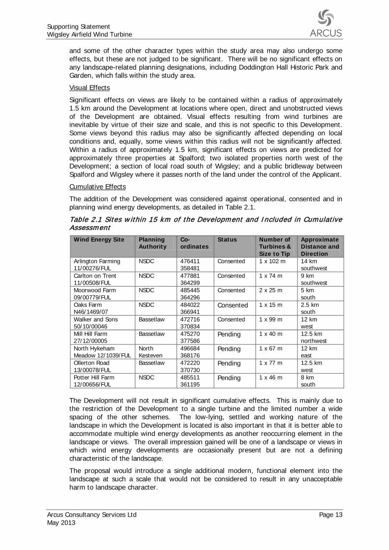
The addition of the Development was considered against operational, consented and in planning wind energy developments, as detailed in Table 2.1.
Cumulative Effects
Table 2.1 Sites w ithin 15 km of the Development and Included in Cumulative Assessment
Wind Energy Site Planning Authority
Co-ordinates
Status Number of Turbines & Size to Tip
Approximate Distance and Direction
Arlington Farming 11/00276/FUL
NSDC 476411 358481
Consented 1 x 10² m 14 km southwest
Carlton on Trent 11/00508/FUL
NSDC 477881 364299
Consented 1 x 74 m 9 km southwest
Moorwood Farm 09/00779/FUL
NSDC 485445 364296
Consented 2 x 25 m 5 km south
Oaks Farm N46/1469/07
NSDC 484022 366941
Consented 1 x 15 m 2.5 km south
Walker and Sons 50/10/00046
Bassetlaw 472716 370834
Consented 1 x 99 m 12 km west
Mill Hill Farm 27/12/00005
Bassetlaw 475270 377586
Pending 1 x 40 m 12.5 km northwest
North Hykeham Meadow 12/1039/FUL
North Kesteven
496684 368176
Pending 1 x 67 m 12 km east
Ollerton Road 13/00078/FUL
Bassetlaw 472220 370730
Pending 1 x 77 m 12.5 km west
Potter Hill Farm 12/00656/FUL
NSDC 485511 361195
Pending 1 x 46 m 8 km south
The Development will not result in significant cumulative effects. This is mainly due to the restriction of the Development to a single turbine and the limited number a wide spacing of the other schemes. The low-lying, settled and working nature of the landscape in which the Development is located is also important in that it is better able to accommodate multiple wind energy developments as another reoccurring element in the landscape or views. The overall impression gained will be one of a landscape or views in which wind energy developments are occasionally present but are not a defining characteristic of the landscape.
The proposal would introduce a single additional modern, functional element into the landscape at such a scale that would not be considered to result in any unacceptable harm to landscape character.
Supporting Statement Wigsley Airfield Wind Turbine
Page 14 Arcus Consultancy Services Ltd May 2013
The Development is therefore considered to comply with the requirements of Core Strategy Core Policies 3, 9 and 13, and the NPPF in these respects.
2.4.2 Ecology and Ornithology
The following development plan policies set out the protection of designated sites and protected species:
‘Saved’ Local Plan Policy NE14: Habitat Replacement
‘Saved’ Local Plan Policy NE15: Management of Wildlife Sites
‘Saved’ Local Plan Policy NE17: Species Protection
‘Saved’ Local Plan Policy PU5: Water Environment
Core Strategy Spatial Policy 3: Rural Areas
Core Strategy Core Policy 9: Sustainable Design
Core Strategy Core Policy 12: Biodiversity and Green Infrastructure
These Development Plan policies, in essence, aim to provide policy protection to protected habitats and species and more broadly promote ecological interests in developments, on similar lines to NPPF guidance.
An Ecology and Ornithology Appraisal has been carried out, as presented in Appendix 2, which considered the ecology survey area to be of relatively low sensitivity in relation to potential ecological or ornithological effects. The appraisal concluded the following:
• No designated sites of nature conservation value will be adversely affected by the Development.
• Habitat losses will be very small (0.01ha) and limited to habitats of low ecological value.
• No adverse effects on protected species are predicted. Mitigation measures are recommended to minimise the risk of harm to badgers.
• The turbine is located far away from features with potential to support roosting, foraging, and commuting bats and adverse effects are therefore unlikely.
• Breeding wildfowl and farmland birds may be disturbed during construction of the Development but there would be no discernible effect on their regional populations. Sensitive timing of construction works, or pre-construction surveys, are recommended to minimise the disruption to breeding birds.
• If construction is to be carried out during the breeding season (March-August) then breeding barn owl surveys will be required to minimise the risk of disturbance to Schedule 1 barn owl.
Given the location and scale of the proposed turbine and nature of the receiving environment, the Development is not considered to have an adverse effect on ecological or ornithological interests. The Development is therefore considered to comply with the requirements of Local Plan Policies NE14, NE15, NE17 and PU5; Core Strategy Core Policies 3, 9 and 12 and the NPPF, in this respect.
2.4.3 Cultural Heritage
The following development plan policies set out the protection of listed buildings, archaeological sites and historic gardens:
‘Saved’ Local Plan Policy C11: Setting of Listed Buildings
‘Saved’ Local Plan Policy C20: Historic Parks and Gardens
‘Saved’ Local Plan Policy C21: Stoke Field Historic Battlefields
Supporting Statement Wigsley Airfield Wind Turbine
Arcus Consultancy Services Ltd Page 15 May 2013
‘Saved’ Local Plan Policy C22: Scheduled Ancient Monuments and Archaeological Sites of Major Local Importance
‘Saved’ Local Plan Policy C25: Archaeological Record
Core Strategy Core Policy 9: Sustainable Design
Core Strategy Core Policy 14: Historic Environment
‘Saved’ Local Plan policies C11, C20, C21 and C22 are restrictive policies that set out not to grant planning permission which adversely affects these designated heritage assets. These policies are not considered to be consistent with NPPF, as they do not seek to balance any harm, even where there is ‘less than substantial harm’, with any other benefits of the Development (NPPF paragraph 134). These policies are therefore not consistent with the NPPF and less weight should be attached to them in the decision making process.
Appendix 3 of this document contains an Archaeology and Cultural Heritage Statement which provides more details on the known archaeology and cultural heritage within the wider study area and discusses the archaeological potential of the Development.
The Development will have no direct impacts upon Scheduled Monuments, Listed Buildings, Registered Parks and Gardens or Conservation Areas. The Development may directly impact remains relating to the former Wigsley Airfield site and it is proposed that a suitable programme of recording is enabled to achieve preservation by record.
It is considered that there is further low potential for unknown subsurface archaeology of local to regional importance to be located at the Application site. It is, therefore, proposed that an appropriate programme of archaeological investigation in the form of a Watching Brief is undertaken. It is anticipated that the agreed works could be carried out in response to an appropriately worded planning condition.
The Archaeology and Heritage Statement appraises the potential for indirect (setting) effects within 5 km on four Scheduled Monuments (SM); three Grade I and four Grade II* listed buildings; four conservation areas; and within 2 km, one Grade II listed building. Slight changes are only predicted in respect of SMs at Roman Fort and Camp, Newton-upon-Trent and the remains of a preceptor, fishponds and post medieval gardens at Eagle Hall; the listed Church of All Saints, North Scale; and North Scale, Gifton and South Clifton conservation areas. However, there is not anticipated to be any change to the significance of the settings of these designated heritage assets. No change to the setting of the other heritage assets within 5 km are predicted.
The Grade I listed Doddington Hall and associated Grade II* Registered Historic Park and Garden were also assessed. Whilst the Development will be marginally visible from the Hall and Historic Garden, it will leave the setting, and the ability to understand, appreciate and interpret the Hall and Historic Garden, intact.
No significant indirect effects have been identified upon the settings of the surrounding cultural heritage features which are considered to affect the value and significance of those features; as such no mitigation has been proposed or is considered necessary.
The Development is considered to comply with the remaining policies in the Development Plan which are consistent with the NPPF. There is minimal effect on designated heritage assets. This would equate to ‘less than substantial harm’ under the NPPF, outweighed by the public benefits of the Development, as renewable energy development.
Supporting Statement Wigsley Airfield Wind Turbine
Page 16 Arcus Consultancy Services Ltd May 2013
2.4.4 Hydrology and Flood Risk
2.4.4.1 Policy Context
The following development plan policies set out the protection of water resources and flooding:
‘Saved’ Local Plan Policy PU1: Washlands;
‘Saved’ Local Plan Policy PU4: Aquifer Protection;
‘Saved’ Local Plan Policy PU5: Water Environment;
Core Strategy Core Policy 9: Sustainable Development; and
Core Strategy Core Policy 10: Climate Change.
The consistency of ‘Saved’ Local Plan policy PU1 in respect of the NPPF is set out in section 2.3.2 above, and similarly the restrictive wording of ’Saved’ polices PU4 and PU5 are not considered consistent with the NPPF. The NPPF sets out to direct inappropriate development away from areas at highest risk, but where it is necessary, making it safe without increasing flood risk elsewhere. Where new development is brought forward in areas which are vulnerable from flooding, the NPPF advises that risks need to be managed through suitable adaptation measures (paragraphs 99-100). Core Strategy Core Policy 10 similarly sets out that development should be located to avoid both present and future flood risk, applying a sequential approach and securing flood mitigation measures.
The ‘Technical Guidance to the National Planning Policy Framework’ (2012)7
2.4.4.2 Baseline Conditions
(‘the Technical Guidance’) provides further guidance, including on the application of the Sequential and Exception Tests, and the content on Flood Risk Assessments (FRA).
A review of Ordnance Survey, aerial photography and site visits identified that there are a number of surface water features and drainage ditches within the vicinity of the Development:
Surface Water
• A man made reservoir, approximately 250 m west of the Development;
• Three ponds located within in Wigsley Wood, approximately 430 m north of the Development;
• Drain orientated north-south approximately 520 m west of the Development.
Given the overland distance between construction areas and the abovementioned receptors, any silt or other materials carried by overland flow as a result of the Development are likely to be entrained in vegetation (in the absence of intervening good practice measures) before reaching watercourses or reservoirs.
Construction good practice measures8,9
7 Department of Communities and Local Government, “Technical Guidance to the National Planning Policy Framework”, 2012, [online] Available at: https://www.gov.uk/government/uploads/system/uploads/attachment_data/file/6000/2115548.pdf [Accessed 08/04/2013].
will also be implemented at the Application site. As a result, there will be no impacts from the Development on hydrology, hydrogeology and related resources. As there are no significant hydrological effects predicted as a result of the Development the need for Sustainable Urban Drainage Systems (SUDS) will
8 CIRIA (2010) Environmental Good Practice on Site Guide 3rd Edition. C692. [online] Available at: http://www.ciria.org [Accessed 25/02/2013]. 9 CIRIA (2001) Control of Water Pollution from Construction Sites. [online] Available at: http://www.ciria.org/acatalog/c532.pdf [Accessed 25/02/2013].
Supporting Statement Wigsley Airfield Wind Turbine
Arcus Consultancy Services Ltd Page 17 May 2013
be negligible. There are no unacceptable hydrological effects predicted as a result of the Development.
There are no statutory designations (e.g. SSSIs and SACs) specifically citing hydrology as a qualifying interest within 5 km of the Development. It is considered that at this distance attenuation and dilution over distance of potentially polluting chemicals and sediment would occur (in the absence of good practice measures) before reaching the designations beyond 5 km.
The Application site lies outside all three EA Groundwater Source Protection Zones
Groundwater 10
The British Geological Survey Borehole records to the west and east of the turbine location indicate that groundwater levels within 2 km are variable. Borehole records for Wigsley Airfield, approximately 460 m east and 630 m south west of the turbine, show groundwater was struck at 2.8 m and 3.8 m below ground level (BGL), which corresponds with the presence of a layer of clay at the same depth.
, and thus would have no impact on aquifer protection.
To prevent pollution of the groundwater / near-surface water resource it is important that all concrete pours are planned and that specific procedures are adopted where there may be a risk of groundwater contamination, in accordance with CIRIA C532. These procedures will likely include:
• Lining the foundation excavation with an impermeable geotextile membrane to ensure that any exposed bedrock is covered. This will limit the potential for concrete fines to enter groundwater via fissures in the underlying mudstone.
• A wooden shuttering casing will be installed on top of the impermeable geotextile layer on the internal edges of the turbine foundation. This will prevent concrete leaching into groundwater or surface water;
• An impermeable geotextile membrane will be placed around wooden shutter casings during concrete pouring. This will prevent concrete leaching into groundwater or surface water in the event of shutter collapse;
• No chemical additives or bitumen will be used to seal the impermeable geotextile layer. This will prevent chemicals leaching into groundwater or surface water;
• Ensuring that all excavations are sufficiently dewatered before concrete pours begin and that dewatering continues while the concrete cures. However, construction good practice will be followed to ensure that fresh concrete is isolated from the dewatering system; and
• Ensuring that covers are available for freshly placed concrete to avoid the surface of the concrete washing away during heavy precipitation.
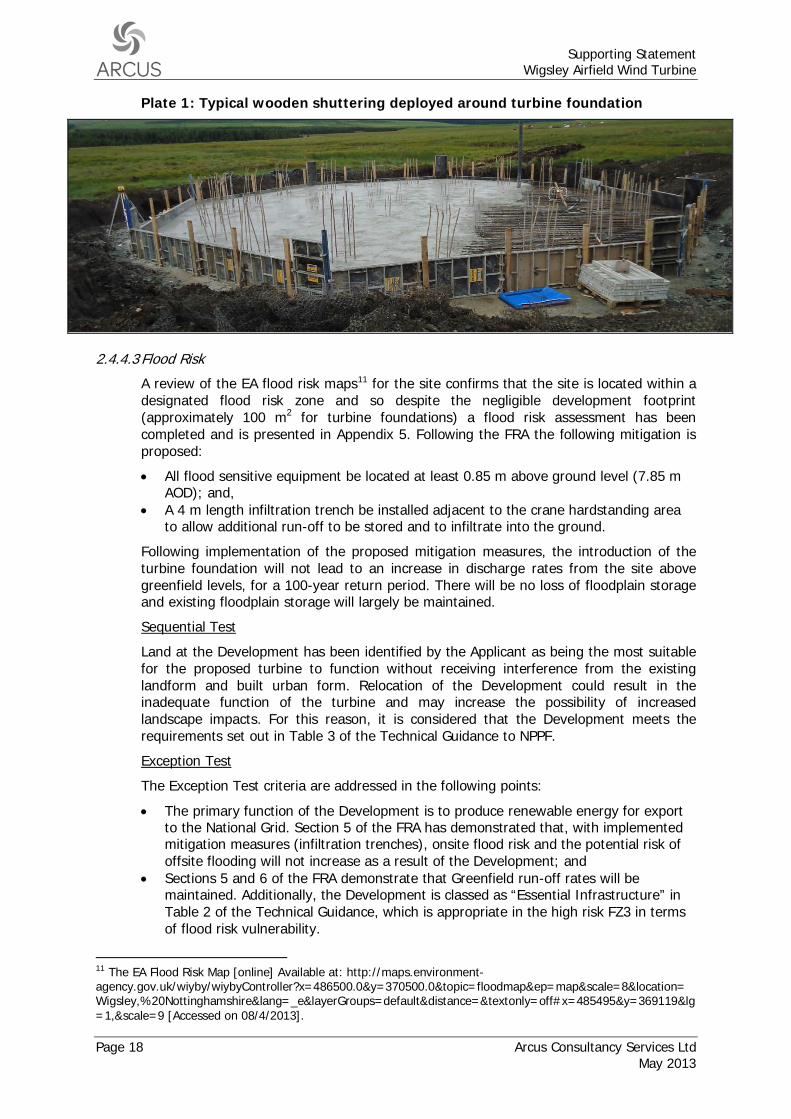
Additionally, no chemical additives will be used during the concrete pour for the turbine foundation. Typical foundation shuttering is shown in Plate 1 below.
10 The EA Groundwater Source Protection Zones Map [online] Available at: http://maps.environment-agency.gov.uk/wiyby/wiybyController?x=486500.0&y=370500.0&topic=groundwater&ep=map&scale=9&location=Wigsley,%20Nottinghamshire&lang=_e&layerGroups=default&distance=&textonly=off#x=486500&y=370500&lg=1,&scale=8 [Accessed on 08/4/2013].
Supporting Statement Wigsley Airfield Wind Turbine
Page 18 Arcus Consultancy Services Ltd May 2013
Plate 1: Typical wooden shuttering deployed around turbine foundation
2.4.4.3 Flood Risk
A review of the EA flood risk maps11
• All flood sensitive equipment be located at least 0.85 m above ground level (7.85 m AOD); and,
for the site confirms that the site is located within a designated flood risk zone and so despite the negligible development footprint (approximately 100 m2 for turbine foundations) a flood risk assessment has been completed and is presented in Appendix 5. Following the FRA the following mitigation is proposed:
• A 4 m length infiltration trench be installed adjacent to the crane hardstanding area to allow additional run-off to be stored and to infiltrate into the ground.
Following implementation of the proposed mitigation measures, the introduction of the turbine foundation will not lead to an increase in discharge rates from the site above greenfield levels, for a 100-year return period. There will be no loss of floodplain storage and existing floodplain storage will largely be maintained.
Land at the Development has been identified by the Applicant as being the most suitable for the proposed turbine to function without receiving interference from the existing landform and built urban form. Relocation of the Development could result in the inadequate function of the turbine and may increase the possibility of increased landscape impacts. For this reason, it is considered that the Development meets the requirements set out in Table 3 of the Technical Guidance to NPPF.
Sequential Test
The Exception Test criteria are addressed in the following points:
Exception Test
• The primary function of the Development is to produce renewable energy for export to the National Grid. Section 5 of the FRA has demonstrated that, with implemented mitigation measures (infiltration trenches), onsite flood risk and the potential risk of offsite flooding will not increase as a result of the Development; and
• Sections 5 and 6 of the FRA demonstrate that Greenfield run-off rates will be maintained. Additionally, the Development is classed as “Essential Infrastructure” in Table 2 of the Technical Guidance, which is appropriate in the high risk FZ3 in terms of flood risk vulnerability.
11 The EA Flood Risk Map [online] Available at: http://maps.environment-agency.gov.uk/wiyby/wiybyController?x=486500.0&y=370500.0&topic=floodmap&ep=map&scale=8&location=Wigsley,%20Nottinghamshire&lang=_e&layerGroups=default&distance=&textonly=off#x=485495&y=369119&lg=1,&scale=9 [Accessed on 08/4/2013].
Supporting Statement Wigsley Airfield Wind Turbine
Arcus Consultancy Services Ltd Page 19 May 2013
2.4.4.4 Private Water Supplies
Newark and Sherwood District Council and North Kesteven District Council have confirmed through consultation that there are no private water supplies within 2 km of the turbine location. As such, no impacts on private water supplies are predicted.
2.4.4.5 Commentary
Given the separation distances to potential hydrological receptors, there are no significant impacts predicted as a result of the Development. The need for SUDS will be negligible due to the small footprint of the Development.
Following mitigation proposed as part of the FRA the Development is considered to comply with remaining policies in the Development Plan which are consistent with the NPPF, and the NPPF in this respect.
2.4.5 Residential Amenity
2.4.5.1 Noise
There are no saved policies from the Local Plan or Core Strategy which relate to noise. The NPPF identifies there is a need for planning decisions to mitigate and reduce to a minimum, adverse impacts arising from noise from new development (paragraph 123).
The closest residential properties were identified along Sand Lane/ Spalford Road and Wigsley Road at distances of 600 m southwest, 625 m south southeast and 645 m southwest of the proposed turbine. The closest residential property in Wigsley village (on Mill Lane) is more than 1.1 km northeast of the proposed turbine.
Assessment of noise from the operation of the Development has been carried out, following the recommendations of ETSU-R-97, the method of assessing wind turbine noise recommended by Government Guidance.
No noise-sensitive properties are predicted to experience noise levels greater than their respective fixed lower limits at wind speeds up to 10 ms-1 as a result of operation of the development alone. As such, the Development in isolation would comply with the ETSU-R-97 simplified noise criterion.
The cumulative effects of the Development have also been considered although no other wind turbine developments, operational, consented or application-stage, are considered likely to have a significant effect on cumulative wind turbine noise levels.
It is therefore concluded that the Development, both in isolation and cumulatively, would comply with ETSU-R-97. The impact of the Development upon residential amenity is considered to be not significant, and as such meets the requirements of the NPPF.
2.4.5.2 Visual Amenity
The following development plan policy set out the protection of the visual amenity of residential properties:
Core Strategy Policy 9: Sustainable Development
Core Strategy Policy 9 makes reference to development complimenting the existing built environment, in respect of achieving a high standard of design. It is reasonable to assess the visual amenity of residential properties in this context. The NPPF also makes various references to the need to address visual impacts.
The nearest residential properties on Sand Lane/Spalford Road are some 600 m in distance, or greater, from the Development. There is also intervening planting on the boundaries of the airfield and the gardens of the residential properties, to provide some
Supporting Statement Wigsley Airfield Wind Turbine
Page 20 Arcus Consultancy Services Ltd May 2013
screening, from what would be a single wind turbine. This would further reduce the effect of the Development on the visual amenities of these properties.
The Development is considered to be acceptable with regard to the visual amenities of nearest residential properties, and would comply with Core Strategy Policy 9 and the NPPF, in this respect.
2.4.5.3 Shadow Flicker
There are no saved policies from the Local Plan or policies in the Core Strategy which relate to shadow flicker.
Guidance presented within the Companion Guide describes shadow flicker as:
“under certain combinations of geographical position and time of day, the sun may pass behind the rotors of a wind turbine and cast a shadow over neighbouring properties. When the blades rotate, the shadow flicks on and off. It only occurs inside buildings where the flicker appears through a narrow window opening.”
The flickering may have the potential to cause disturbance and annoyance to residents if it affects occupied rooms of a house. Persons with photosensitive epilepsy are usually sensitive to flickering light that is between 3 to 60 Hertz (Hz)12. The frequencies of flicker caused by modern wind turbines (less than 1 Hz)13,14
As shadow flicker only has the potential to occur during the operational phase of the Development, there would be no effect during construction or decommissioning.
are well below the sensitive range. Therefore, any potential shadow flicker effects from the Development are purely an effect on residential amenity, rather than having the potential to affect the health or well-being of residents.
The Companion Guide advises that the shadow flicker effect can only occur within 130 degrees either side of north relative to the turbine positions, as turbines do not cast long shadows on their southern side. It also advises that the effect is most likely to occur within 10 rotor diameters of the turbine position.
The rotor diameter of the proposed candidate turbine is 54 m giving a distance of 540 m within which shadow flicker effects could potentially occur. No residential dwellings are located within this distance, with the closest residential property located 600 m southwest, and so no shadow flicker effects are anticipated.
2.4.5.4 Television and Other Infrastructure
There are no development plan policies which relate to television reception or other existing infrastructure. The NPPF sets out there is a need for LPAs ensure they have considered the possibility of new buildings or other structures interfering with broadcast and telecommunications services (paragraph 44).
Wind turbines and other structures have the potential to create interference with television and telecommunication transmissions.
Consultation with the BBC via the online assessment tool15
12 Epilepsy Action (2007) Photo-sensitive Epilepsy [online]. Available at: http://www.epilepsy.org.uk/info/photo.html [Accessed on 09/07/2012].
identified that from the proposed turbine location it is considered that no homes for which there is an alternative off-air service would be affected. The turbine is anticipated to affect up to 606 homes for
13 Epilepsy Action (2007) Other Possible Epilepsy Triggers [online]. Available at: http://www.epilepsy.org.uk/info/photo_other.html [Accessed on 20/04/2010]. 14 ODPM (2004) Planning for Renewable Energy: A Companion Guide to PPS 22, pp 177. 15 BBC (2010) Windfarm Assessment Tool [Online] Available at http://www.bbc.co.uk/reception/info/windfarm_tool.shtml Accessed 8/4/2013
Supporting Statement Wigsley Airfield Wind Turbine
Arcus Consultancy Services Ltd Page 21 May 2013
which there may be an alternative off-air service. The transmitters likely to be affected are:
• Emley Moor • Emley Moor Ch 5 • Waltham • Waltham Ch 5 • Belmont • Belmont Ch 5
The proposal would have the potential to affect the television reception of residents, however given that the region has already completed the switch over from analogue to digital TV it is unlikely that there would be any effect. Digital television signals are not generally affected by the operation of wind turbines, however, a minimum signal strength is required for digital television to operate effectively.
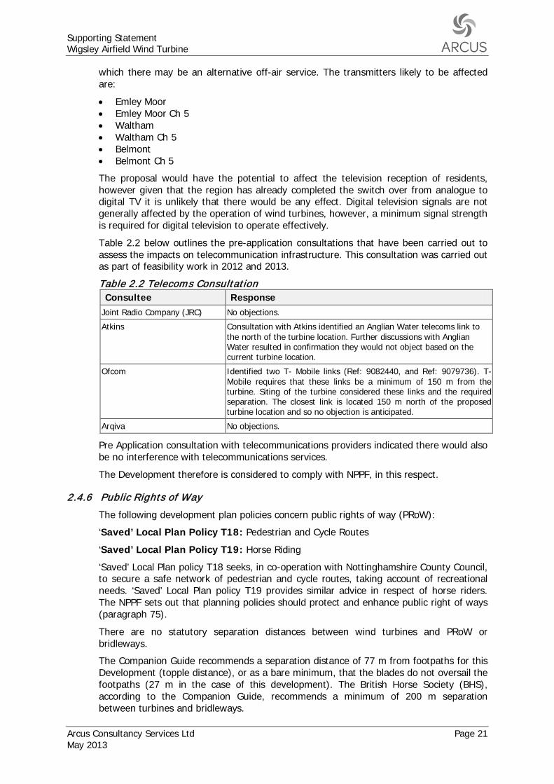
Table 2.2 below outlines the pre-application consultations that have been carried out to assess the impacts on telecommunication infrastructure. This consultation was carried out as part of feasibility work in 2012 and 2013.
Table 2.2 Telecoms Consultation Consultee Response
Joint Radio Company (JRC) No objections.
Atkins Consultation with Atkins identified an Anglian Water telecoms link to the north of the turbine location. Further discussions with Anglian Water resulted in confirmation they would not object based on the current turbine location.
Ofcom Identified two T- Mobile links (Ref: 9082440, and Ref: 9079736). T-Mobile requires that these links be a minimum of 150 m from the turbine. Siting of the turbine considered these links and the required separation. The closest link is located 150 m north of the proposed turbine location and so no objection is anticipated.
Arqiva No objections.
Pre Application consultation with telecommunications providers indicated there would also be no interference with telecommunications services.
The Development therefore is considered to comply with NPPF, in this respect.
2.4.6 Public Rights of Way
The following development plan policies concern public rights of way (PRoW):
‘Saved’ Local Plan Policy T18: Pedestrian and Cycle Routes
‘Saved’ Local Plan Policy T19: Horse Riding
‘Saved’ Local Plan policy T18 seeks, in co-operation with Nottinghamshire County Council, to secure a safe network of pedestrian and cycle routes, taking account of recreational needs. ‘Saved’ Local Plan policy T19 provides similar advice in respect of horse riders. The NPPF sets out that planning policies should protect and enhance public right of ways (paragraph 75).
There are no statutory separation distances between wind turbines and PRoW or bridleways.
The Companion Guide recommends a separation distance of 77 m from footpaths for this Development (topple distance), or as a bare minimum, that the blades do not oversail the footpaths (27 m in the case of this development). The British Horse Society (BHS), according to the Companion Guide, recommends a minimum of 200 m separation between turbines and bridleways.
Supporting Statement Wigsley Airfield Wind Turbine
Page 22 Arcus Consultancy Services Ltd May 2013
A review of Ordnance Survey mapping identified a number of public rights of way within a 1 km radius of the turbine, namely:
• A bridleway circling around the Development at distances of 350 m northeast (at its closest point), 400 m north and 515 m west. Historically this bridleway passed through the former airfield site at a location approximately 70 m north of the turbine location. However, as of 19th February 2013, this bridleway was rerouted to the north, along the southern boundary of Wigsley Wood, under a Diversion and Definitive Map and Statement Modification Order (in relation to Spalford Bridleway No 9 and Wigsley Bridleway No 4). A copy of the modification order is presented in Appendix 6.
• Footpath heading south from Sand Lane/ Spalford Road towards Chapel Lane, passing Windmill Farm. At its closest this footpath is 795 m from the proposed turbine.
The separation distances outlined in the above guidance have been met in the case of the Development. There are not considered to be any direct impacts on PRoW during construction and no significant indirect impacts either during construction or operation of the Development. The Development would therefore comply with ‘Saved’ Local Plan policies T18 and T19, and the NPPF, in this respect.
2.4.7 Access
The following development plan policy concerns access:
‘Saved’ Local Plan Policy T21: Heavy Goods Vehicles
‘Saved’ Local Plan Policy T21 sets out that planning permission will not be granted for development likely to produce substantial traffic movements, especially heavy goods vehicles (HGVs), unless there are good links to the main road network. The restrictive wording of this policy is not considered consistent with the NPPF, which sets out that, whilst safe and suitable access is to be achieved for all people, development should only be prevented or refused on transport grounds where the residual cumulative impacts are severe (paragraph 32).
It is anticipated that the turbine will be delivered to one of the nearest ports. Due to the location of the site, a number of different ports could potentially be utilised, including Goole (63 miles from site via the M62, M18, A1(M) and A1 southbound), Grimsby (58 miles from site via the A46 southbound) and King’s Lynn (65 miles from site via the A17, A52 and A1 northbound).
Road access to the site would be taken along the trunk road network from the chosen port to the A1, then to site via the A46 and the A1133 (Gainsborough Road) until Girton where Girton Lane will be taken eastwards. Hives Lane will be taken to reach Wigsley Road, from which an existing farm access track/ former airfield runway will be taken in a northwesterly direction towards the Application Site. The exisiting site access will be utilised and no new access track will need to be built to access the turbine.
The candidate turbine manufacturer’s specification Transport, Storage and Crane Guidelines (Emergya Wind Technologies BV, 2010) identifies that the following turbine components will require transport to site during construction of the turbine:
• 2x tower sections; • 1x nacelle; • 1x hub • 1x generator • 3x blades; and • 1x converter.
Supporting Statement Wigsley Airfield Wind Turbine
Arcus Consultancy Services Ltd Page 23 May 2013
The three blades are transported within a transport frame as a single unit. The nacelle and hub also share the same vehicle. The remaining loads are each transported on their own vehicle. The generator, the blades pack and the lower tower section are identified by the turbine manufacturer as the most onerous elements to transport, and will be transported on an articulated tractor/ trailer combination with rear wheel steering. A crane will also need to be delivered to site, as may other goods vehicles carrying construction tools and materials.
The following dimensions/ requirements are set out in the Transport, Storage and Crane Guidelines (Emergya Wind Technologies BV, 2010):
• The minimum metalled carriageway width of 3.1 m to accommodate the crane. • The maximum headroom of 4.6 m, considerably less than the minimum clearance
ordinarily provided over public highways (5.03 m). • In the case of the lower tower section the trailer will be extended to a length of 23.5
m. The tower section, at 3.6 m width at its widest point, will overhang each side of the trailer, but not the rear.
• In the case of the blades pack, the trailer will be extended to a length of 26.5 m and the load will not overhang the trailer. It is however possible to reduce the length of the blades trailer to gain improved manoeuvrability in this or other circumstances. This requires the blades pack to overhang the rear of the vehicle by up to 3 m.
• All vehicles will return from the site unloaded, with trailers retracted to a maximum of 18.75 m length, such that they would no longer be of abnormal dimensions.
Concrete will be required for the turbine foundations and such deliveries will be made by HGVs. Given that no new hardstanding areas or access tracks are required, there will not be any HGV traffic associated with the haulage of stone. This will significantly reduce HGV movements, compared to wind turbine developments where access tracks need to be constructed. Light vehicle traffic will also be generated by workers as they travel to site throughout the construction period.
Given the nature of Wigsley Road and the A1133 (Gainsborough Road), from which access will be taken, the small scale of the Development and the short term nature of the construction period (anticipated to be approximately 12-16 weeks), it is anticipated that construction traffic associated with the Development will have negligible traffic flow effects or associated environmental effects during construction.
Traffic generated during the operation phase of the Development will be limited to infrequent routine maintenance, and unplanned maintenance as required, and this is expected to produce less than 20 trips per year. As a result, no significant effects are anticipated. The Development is thus considered to comply with the NPPF, in this respect.
2.4.8 Land Use
The following development plan policies set out the requirement for the protection of high quality agricultural land:
‘Saved’ Local Plan Policy NE3: Agricultural Land
As set out in 3.3.2, ‘Saved’ Local Plan Policy NE3 is not considered to be consistent with the NPPF.
The land beneath, and in the vicinity of, the application site is classified as Agricultural Classification Grade 3 (Good to Moderate quality).
Given that the agricultural classification is not Grade 1 or 2, and that only a very small area of land take will be required (approximately 100 m2) for the wind turbine foundation, no significant land use effects are anticipated. There will be no loss of land required for a laydown area, crane hardstanding pad or access road as existing
Supporting Statement Wigsley Airfield Wind Turbine
Page 24 Arcus Consultancy Services Ltd May 2013
infrastructure will be utilised for these purposes. The Development is thus considered to comply with the NPPF in this respect.
2.4.9 Air Quality
The following development plan policies set out the requirement for the protection of air quality:
Core Strategy Core Policy 9: Sustainable Design
There are no relevant Development Plan policies in respect of air quality. The NPPF sets out that planning policies should sustain compliance with EU limit values or national objectives for pollutants, taking account of the presence of Air Quality Management Areas and cumulative impacts on air quality from individual sites in local areas (paragraph 124).
Wind turbines create no atmospheric pollution during operation, and no effects on local air quality are anticipated. During construction there is the potential for vehicle exhaust emissions and dust. However, given the short term nature of the construction period, distance to nearest residential properties and the high degree of dispersion, no air quality effects are anticipated. The Development is considered to comply with the NPPF in this respect,
2.4.10 Aviation
There are no relevant Development Plan policies in respect of aviation. The NPPF sets out that plans need to take account of the growth of airports and airfields (paragraph 33). Reference is also made in the NPPF to the National Policy Statements16
Wind turbines have the potential to affect civil and military aviation operations.
, in respect of aviation impacts.
An initial review of GIS datasets indicates that there are two CAA aerodromes within 30 km of the site; Retford Gamston Airport, approximately 16.7 km northwest of the proposed turbine, and Wickenby Aerodrome, approximately 27.8 km northeast of the proposed turbine. The Development lies just within the 17 km consultation zone for Retford Gamston Airport but outside the 5 km consultation zone for Wickenby Aerodrome. Retford Gamston Airport have been consulted and confirmed they have no objection to a 77 m turbine at the Application site (see Appendix 7).
The CAA identified two local airfields which may be affected – Retford Gamston Airfield and Grassthorpe Grange Airfield. Retford Gamston is located more than 16.7 km from the site and is situated behind the natural contours of the land. They have been consulted and confirmed they have no objection to a 77 m turbine at the application site (see Appendix 7). Grassthorpe Grange Airfield is located 5.5 km from the site and is an unlicensed airfield and is also located outside the 5 km consultation zone.
Five Ministry of Defence (MoD) bases are located within 30 km of the site: RAF Waddington approximately 13.9 km southeast of the proposed turbine; RAF Scampton approximately 15.5 km northeast; RAF Digby approximately 23.6 km southeast; RAF Syerston approximately 24.1 km southwest; and RAF Cranwell approximately 24.7 km southeast. In addition RAF Kirkton in Lindsey is located approximately 30.4 km northeast and RAF Barkston Heath is located approximately 30.6 km southeast of the proposed turbine. The Application site is identified as being within an area described as ‘Low
16 Department of Energy and Climate Change, “EN-1 Overarching National Policy Statement for Energy Infrastructure”, “ EN-2 Renewable Energy Infrastructure”, both 2011, Available at: https://www.gov.uk/consents-and-planning-applications-for-national-energy-infrastructure-projects
Supporting Statement Wigsley Airfield Wind Turbine
Arcus Consultancy Services Ltd Page 25 May 2013
priority military low flying area less likely to raise concerns’ on the MoD Low Flying Consultation Zones map17
A pre-application consultation request was submitted to the MoD based on a 67 m tip turbine which received a no objection response, a copy of which is presented in Appendix 7. Since this consultation the scale of the turbine has changed and the MoD were re-consulted based on a turbine measuring 77 m to tip. However, due to resourcing issues the MoD stopped responding to pre-application consultation requests so a response on a turbine of 77 m to tip was not received and is not expected until the MoD are consulted as part of this planning application. Should the MoD respond with concerns, then the Applicant would seek to engage with the MoD, review potential effects the site might have and consider the mitigation options that might be available to them to limit the potential effects.
.
Based on the NATS En-Route Ltd (NERL) publically available radar maps, a turbine with a blade tip height of 77 m would be visible to NERL Primary Surveillance Radar (PSR). A NERL pre-planning assessment was commissioned and is presented in Appendix 7. This confirms that the proposal for a 77m tip turbine at the application site does not conflict with NERLs safeguarding criteria and NERL would be unlikely to object to the proposal.
The Development is located approximately 17.4 km southwest of Ingham Meteorological Station and as such, it falls within the 20 km consultation zone. Consultation is carried out by the MoD (on behalf of the Met Office) and no objection was lodged to a 67 m turbine as part of the pre-application consultation detailed above.
The Development is considered to comply with the NPPF in this respect.
2.4.11 Climate Change
The estimate of CO2 offset annually and over the lifetime of the Development, given in Table 2.3, is based on the latest statistics from the Department of Energy and Climate Change (DECC) Digest of UK Energy Statistics 2012. This publication states that, in 2011, 392 tonnes of CO2 were released each GigaWatt hour (GWh) when generating electricity from gas; this increased to 912 tonnes per GWh when generating from coal. The average CO2 release from the fossil fuel mix (including oil) was 609 tonnes per GWh18
Based on a capacity factor of 26.2%
. 19 and an average annual household consumption in
Newark and Sherwood of 4,314 kWh20
17 Ministry of Defence Low Flying Consultation Zones maps are available online at: https://restats.decc.gov.uk/cms/aviation-safeguarding-maps/ [accessed 08/04/2013]
the turbine is expected to offset the electricity usage of approximately 265 houses.
18 DECC (2012) Digest of UK Energy Statistics 2012 (DUKES) Chapter 5 Electricity, Table 5A. Figures for 2011 [online] Available at: http://www.decc.gov.uk/en/content/cms/statistics/publications/dukes/dukes.aspx [Accessed on 09/07/2012]. 19 Based on an unchanged configuration capacity factor of 26.2%, a five year average between 2007 and 2011 taken from DECC Digest of UK Energy Statistics DUKES 2012. Available at: http://www.decc.gov.uk/en/content/cms/statistics/publications/dukes/dukes.aspx [Accessed on 09/07/2012]. 20 Department of Energy and Climate Change, Sub-national local authority electricity consumption statistics 2005-2011.
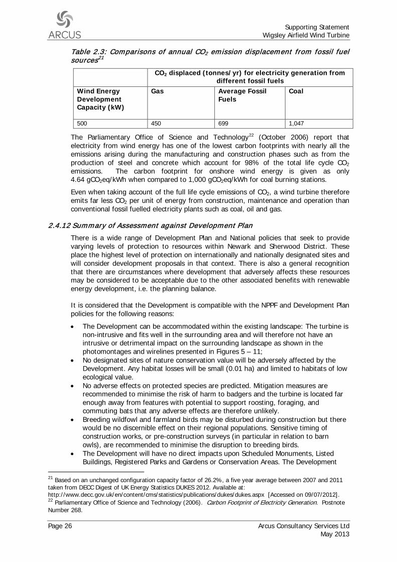
Supporting Statement Wigsley Airfield Wind Turbine
Page 26 Arcus Consultancy Services Ltd May 2013
Table 2.3: Comparisons of annual CO2 emission displacement from fossil fuel sources21
CO2 displaced (tonnes/yr) for electricity generation from different fossil fuels
Wind Energy Development Capacity (kW)
Gas Average Fossil Fuels
Coal
500 450 699 1,047
The Parliamentary Office of Science and Technology22
Even when taking account of the full life cycle emissions of CO2, a wind turbine therefore emits far less CO2 per unit of energy from construction, maintenance and operation than conventional fossil fuelled electricity plants such as coal, oil and gas.
(October 2006) report that electricity from wind energy has one of the lowest carbon footprints with nearly all the emissions arising during the manufacturing and construction phases such as from the production of steel and concrete which account for 98% of the total life cycle CO2 emissions. The carbon footprint for onshore wind energy is given as only 4.64 gCO2eq/kWh when compared to 1,000 gCO2eq/kWh for coal burning stations.
2.4.12 Summary of Assessment against Development P lan
There is a wide range of Development Plan and National policies that seek to provide varying levels of protection to resources within Newark and Sherwood District. These place the highest level of protection on internationally and nationally designated sites and will consider development proposals in that context. There is also a general recognition that there are circumstances where development that adversely affects these resources may be considered to be acceptable due to the other associated benefits with renewable energy development, i.e. the planning balance.
It is considered that the Development is compatible with the NPPF and Development Plan policies for the following reasons:
• The Development can be accommodated within the existing landscape: The turbine is non-intrusive and fits well in the surrounding area and will therefore not have an intrusive or detrimental impact on the surrounding landscape as shown in the photomontages and wirelines presented in Figures 5 – 11;
• No designated sites of nature conservation value will be adversely affected by the Development. Any habitat losses will be small (0.01 ha) and limited to habitats of low ecological value.
• No adverse effects on protected species are predicted. Mitigation measures are recommended to minimise the risk of harm to badgers and the turbine is located far enough away from features with potential to support roosting, foraging, and commuting bats that any adverse effects are therefore unlikely.
• Breeding wildfowl and farmland birds may be disturbed during construction but there would be no discernible effect on their regional populations. Sensitive timing of construction works, or pre-construction surveys (in particular in relation to barn owls), are recommended to minimise the disruption to breeding birds.
• The Development will have no direct impacts upon Scheduled Monuments, Listed Buildings, Registered Parks and Gardens or Conservation Areas. The Development
21 Based on an unchanged configuration capacity factor of 26.2%, a five year average between 2007 and 2011 taken from DECC Digest of UK Energy Statistics DUKES 2012. Available at: http://www.decc.gov.uk/en/content/cms/statistics/publications/dukes/dukes.aspx [Accessed on 09/07/2012]. 22 Parliamentary Office of Science and Technology (2006). Carbon Footprint of Electricity Generation. Postnote Number 268.
Supporting Statement Wigsley Airfield Wind Turbine
Arcus Consultancy Services Ltd Page 27 May 2013
may directly impact remains relating to the former Wigsley Airfield site and it is proposed that a suitable programme of recording is enabled to achieve preservation by record. There is also further low potential for unknown subsurface archaeology of local – regional importance to be located at the Development site. It is therefore proposed that an appropriate programme of archaeological investigation (potentially a Watching Brief) is undertaken;
• No indirect effects have been identified upon the settings of the surrounding cultural heritage features which are considered to affect the value and significance of those features;
• There are a number of surface water features and drainage ditches within the vicinity of the Development including a man-made reservoir, approximately 250 m west of the Development, ponds in Wigsley Wood, approximately 430 m north of the Development and a drain orientated north-south approximately 520 m west of the Development. The principle surface water course in the vicinity of the Development is the River Trent, located approximately 3 km west. Direct impacts on these water features, as a result of the Development, are considered unlikely;
• The site is located in a designated flood risk zone and so despite the negligible development footprint (approximately 100 m2 for turbine foundations) a flood risk assessment has been completed and mitigation proposed to ensure there are no residual flood risk impacts. Flood sensitive equipment will be raised 0.85 m above ground level and a 4 m long infiltration trench will be installed;
• The Development has a need to be located within the countryside due to the nature of wind turbines which have numerous requirements which dictate the areas within which they can be located. Principally, wind turbines require to be located within areas which have the following: − Suitable wind speed; − Free from obstruction that would affect wind flow; − Suitable road network for turbine component deliveries; − Suitable ground conditions to support the structures; − Availability of grid connection; and − Suitable separation from residential property to avoid noise effects.
An urban environment would commonly not be appropriate, predominately from a space and wind flow perspective. A location in the countryside enables access to all of the above thus making the Application Site suitable for the Development.
• Minimising the loss of undeveloped land. Only a very small area of land take will be required (approximately 100 m2) for the wind turbine foundation. No land loss will be required for a laydown area, crane hardstanding or access road as existing infrastructure will be utilised for this;
• Wind turbines create no atmospheric pollution during operation, and no effects on local air quality are anticipated. During construction there is the potential for vehicle exhaust emissions and dust. However, given the short term nature of the construction period, distance to nearest residential properties and the high degree of dispersion, no air quality effects are anticipated.
2.5 Material Considerations
In addition to the NPPF, discussed in Section 2.1, there are a range of other material considerations that will be taken into account when determining this application. This section sets out the national planning policy and guidance that is considered to be material in the consideration and determination of this planning application.
Supporting Statement Wigsley Airfield Wind Turbine
Page 28 Arcus Consultancy Services Ltd May 2013
2.5.1 Strategic Environmental Assessment of the Revocation of the East Midlands Regional Strategy Post Adoption Statement (2013)
The Strategic Environmental Assessment of the Revocation of the East Midlands Regional Strategy Post Adoption Statement23
In respect of the justification for the revocation of policies directly relevant to climate change and renewable energy, the Adoption Statement attaches significant weight to the support for renewable energy development that already exists through the NPPF, energy policy and legislation, and duties on LPAs in respect of climate change (Table 3.2, page 27):
(‘The Adoption Statement’) sets out the reasons by Central Government for revoking the EMRP. It is a requirement of the Strategic Environmental Assessment process.
“The National Planning Policy Framework’s proactive, plan led approach sits within a wider set of requirements and policy initiatives to deliver renewable energy. These include the UK’s legally binding target that by 2020 15% of energy should come from renewable energy. Additionally, there is a specific duty on Local Planning Authorities to ensure their local plan includes policies designed to mitigate climate change”
The Adoption Statement is also clear that LPAs have to respond to the legislative requirements that arise from the setting of national targets for renewable energy (Table B1, pages 203-204, fourth column):
“Other measures that local authorities will need to respond to include the nationally legally-binding target to ensure 15% of energy comes from renewable sources by 2020 (in accordance with the Renewables Energy Directive (2009/28/EC)), the requirements of the Climate Change Act 2008, the Flood and Water Management Act 2010, the UK Renewable Energy Strategy 2009, the UK National Renewable Action Plan 2010, the Green Deal and responses to the UK Climate Change Risk Assessment 2012.
Collectively the legislation and planning policy provides the framework for Government, agencies and local authorities to act in concert to respond to the challenge of climate change.”
The Adoption Statement also sets out monitoring indicators that Central Government will utilise periodically in respect of reviewing the effects of revocation of the EMRP. In respect of climatic factors, Central Government will monitor regionally the emissions of greenhouse gases and the installed capacity of sites generating electricity from renewable resources. Monitoring will thus still be carried out at the regional level in respect of renewable energy development, to ensure LAs are contributing favourably to the national legally binding targets.
Whilst the EMRP has been revoked, it is clear from the Adoption Statement, that Central Government does not view this in any way reduces the role of LPAs in combatting climate change and meeting the requirements of energy policy and associated legally binding targets, in respect of renewable energy development.
2.5.2 Newark and Sherwood Allocations and Development Management Development P lan Document - Publication (2012)
Policy DM4 Renewable and Low Carbon Energy Generation of the Allocations and Development Management DPD sets out a permissive policy, to achieve the carbon reduction commitments as set out in Core Strategy Policy 10. Policy DM4 states that planning permission will be granted for renewable and low carbon development, unless
23 Department of Communities and Local Government, “Strategic Environmental Assessment of the Revocation of the East Midlands Regional Strategy Post Adoption Statement”, 2013. Available at: https://www.gov.uk/government/uploads/system/uploads/attachment_data/file/153560/Strategic_Environmental_Assessment_of_the_Revocation_of_the_East_Midlands_Regional_Strategy_-_Post_Adoption_Statement.pdf.
Supporting Statement Wigsley Airfield Wind Turbine
Arcus Consultancy Services Ltd Page 29 May 2013
its benefits are not outweighed by detrimental impacts in respect of landscape character or urban form of the district or purposes of land within the Green Belt, either individually or cumulatively; Southwell Views or the setting of Thurgarton Hundred Workhouse; heritage assets or their settings; amenity including noise pollution, shadow flicker and electromagnetic interference; highway safety; ecology of the local or wider area; or aviation interests of local or national importance. Compliance with these matters, as is relevant to the Development, is set out in section 2.4.
The supporting text to Policy DM4 is clear the renewable energy has an important role in respect of mitigating and adapting to climate change over the plan period (paragraph 7.3):
“securing new sources of renewable and low carbon energy production will make an important contribution to this.”
The Development fully accords with emerging Policy DM4 of the Allocations and Development Management DPD.
2.5.3 Supplementary P lanning Guidance – Wind Energy 1999
This Supplementary Planning Guidance (‘the SPG’)24
Policy W1: Wind Turbines in the Countryside advises that planning permission will be granted for wind turbines located in the countryside where:
, prepared by NSDC, and adopted in 1999, outlines three policies which will be considered key to the determination of wind energy developments. These are outlined below.
• “The environmental impacts of noise generation, shadow flicker and electromagnetic disturbance are acceptable;
• The individual or cumulative effect of turbines in the countryside do not create an unacceptable visual impact on the landscape; and
• The development achieves a net gain.”
In the event that a proposal for a single or group of turbines detrimentally effects any of the following designations, directly or indirectly, the overall acceptability of the scheme will be measured against the scale of effect on the intrinsic value of the surrounding area, and the reason that area has been designated:
• Sherwood Forest Heritage Area; • Sherwood Forest Special Landscape Area; • Mature Landscape Areas; and • Historic Landscape around Laxton.
Any proposal for wind turbines in the countryside will be expected to be accompanied by a statement which indicates why the design, height, number, colour, density of turbines and blade diameter are considered most appropriate to the site location. The statement should also advise the details of any grid connection, or whether the turbines are to serve a local community or development. Access arrangements will also be expected to be outlined in the supporting statement. Additionally, it is likely that there will be a condition imposed on any consent to ensure that the site is fully restored upon decommissioning.
The Development is in compliance with SPG Policy W1 as it has been demonstrated that noise, shadow flicker and electromagnetic disturbance impacts are acceptable. As demonstrated by the Landscape and Visual Appraisal (Appendix 1), the impacts of the
24 Newark and Sherwood District Council, 1999, “Supplementary Planning Guidance – Wind Energy 1999”. Available online at: www.newark-sherwooddc.gov.uk/media/newarkandsherwood/imagesandfiles/planningpolicy/pdfs/supplementaryplanning documents/Wind%20Energy%20SPG.pdf
Supporting Statement Wigsley Airfield Wind Turbine
Page 30 Arcus Consultancy Services Ltd May 2013
Development, both in isolation and cumulatively, have been considered and found to be acceptable. There are also no direct or indirect effects on the Sherwood Forest Heritage Area, the Sherwood Forest Special Landscape Area, mature landscape areas or the historic landscape around Laxton.
Policy W2: The Impact of Wind Turbines on Wildlife and Human Heritage Designations states that consent will not be granted for wind turbines that will:
• Either directly or indirectly result in the loss of the designated interest of any of the following designations:
• Birklands and Bilhaugh (candidate SAC); • SSSIs; • SINCs; • SAMs or Archaeological Sites of Major Local Importance; • Conservation Areas; and • Historic Parks and Gardens. • Have a serious long-term impact on migratory or transient species listed in the
National or Local Biodiversity Action Plans or protected under the provisions of the Wildlife and Countryside Act 1981 (as amended).
The Local Authority will apply the “precautionary principle” to all proposals where there is reasonable doubt concerning the conclusions reached as a result of any ecological impact assessment undertaken.
The Development is also compliant with SPG Policy W2 as there will be no loss of the designated interest of any of the assets listed. The Development is also not considered to have any long term impact on migratory or transient species listed in the National or Local Biodiversity Action Plans or protected under the provisions of the Wildlife and Countryside Act 1981 (as amended).
Policy W3: Wind Turbines associated with Existing or Proposed Employment Development is not considered relevant to the Development.
2.5.4 Low Carbon Energy Opportunities and Heat Mapping for Local P lanning Areas across the East Midlands: Final Report (2011)
The Low Carbon Energy Opportunities and Heat Mapping for Local Planning Areas Across the East Midlands Final Report25
The Low Carbon Energy Opportunities Report sets out the technical potential for renewable energy within each of the county areas, and their constituent Councils. For Newark and Sherwood, a technical potential of 1,279.83 MW of capacity is identified up to 2020 for electricity, of which 675.02 MW is large wind. The Report states (paragraph 4.21) there is “considerable commercial wind energy potential”.
(‘The Low Carbon Energy Opportunities Report’) reviews the potential for low carbon energy within the East Midlands. The aim is to prepare a comprehensive evidence base that would allow LPAs across the region to develop well-funded policies that support low carbon energy development up to 2030. The Low Carbon Energy Opportunities Report identifies that, whilst the Government has confirmed its intention to abolish Regional Spatial Strategies, there remains a strong imperative for regional planning to ensure that the approach to increasing the supply of renewable and low carbon energy is consistent.
The technical resource potential does not equate to the deployable potential, and will represent an overestimate of what can be practically delivered, as it assumes all
25 Prepared for East Midlands Councils by Land Use Consultants, Centre for Sustainable Energy and SQW, 2011, “Low Carbon Energy Opportunities and Heat Mapping for Local Planning Areas Across the East Midlands: Final Report”, Available on line http://www.emcouncils.gov.uk/write/Emids-low-carbon-energy-opportunities-Final-Report-07-2011-update.pdf
Supporting Statement Wigsley Airfield Wind Turbine
Arcus Consultancy Services Ltd Page 31 May 2013
unconstrained land will be developed for onshore wind and cumulative impacts are not taken account. However, in deriving the technical resource the potential wind speeds; size/density of turbines; transport routes; property buffers; environmental protection (including cultural heritage and protected landscape designations) and aviation constraints were taken into account.
Onshore wind energy opportunity plans were produced for each constituent Council; for Newark and Sherwood, the Application Site lies in an area of highest potential for large scale wind and outside of sensitive areas.
The Low Carbon Energy Opportunities Report is thus highly supportive, in principle, both of renewable energy development and specifically in the location where the Development would be located.
2.5.5 Planning for Renewable Energy a Companion Guide to PPS 22
The Companion Guide offers practical advice as how to renewable energy policies are to be implemented. The key themes of the Guide are the wider benefits of renewable energy schemes, the importance of community involvement, the use of criteria-based policies in plans and the need for integration with other plans and policies. Technical Annex 8 to the Companion Guide provides guidance with respect to wind farms, and associated infrastructure. The Annex also provides further guidance on a number of specific planning issues including noise, landscape and visual impact, listed buildings and conservation areas, safety, proximity to roads, railways and rights of way, ecology and ornithology, electromagnetic interference, shadow flicker, archaeology, construction and operational disturbance and aviation matters.
2.5.6 Energy and Climate Change Policy
2.5.6.1 Renewable Energy Directive 2009/28/EC (2009)
The EU undertook further work in 2006 through the production of an Energy Review Report, and an agreed European Strategy in 2007 to commit further to improve energy security and reduce emissions. The EU subsequently introduced the Renewable Energy Directive 2009/28/EC in April 200926
• Reduce greenhouse gas emissions by 30% by 2020 and reduce them by 60-80% by 2050; and
, which sets mandatory national targets for the overall share of energy from renewable resources and sets a common framework across the EU for the promotion of renewable energy. The states within the EU have agreed to undertake the following:
• Reduce the EU’s energy consumption by 20% by 2020.
The Directive also sets targets for Member States in respect of use of energy from renewable sources. The UK’s legally binding obligation is 15% of energy coming from renewable resources by 2020.
2.5.6.2 Climate Change Act (2008)
The Climate Change Act (2008)27
26 Directive 2009/28/EC of the European Parliament and of the Council, “Promotion of the Use of Energy from renewable sources and amending and subsequently repealing Directives 2001/77/EC and 2003/30/EC”, European Union
(‘the 2008 Act’) sets a legally binding target to reduce UK carbon emissions by 80% by 2050 and reducing targets of at least 34% by 2020, against a 1990 baseline. As these targets are legally binding, significant weight should be attached to the need to achieve these targets.
27 Climate Change Act 2008, “Climate Change Act 2008”, HMSO
Supporting Statement Wigsley Airfield Wind Turbine
Page 32 Arcus Consultancy Services Ltd May 2013
The 2008 Act also established the Committee on Climate Change (‘The CCC’) which reports on progress to which the UK Government must respond, so that it is held to account towards the 2020 and 2050 targets. The 2008 Act also commits the UK Government to more investment in renewable energy, specifically in wind and wave, so as to provide more clarity for business.
2.5.6.3 The Coalition: Our Programme for Government (2010)
The Coalition: Our Programme for Government – May 201028 supports increasing the target for energy from renewable resources and supports increasing the EU emission reduction target to 30% by 2020. By July 2010, the Coalition Government had confirmed its commitment to securing the UK’s commitments to securing energy supply and renewable consumption through the National Renewable Energy Action Plan29
2.5.6.4 Renewable Energy Review (2011)
. The Action Plan states that “The UK will need to radically increase its use of renewable energy”. The key elements of the Coalition Government Programme for Government are provided for by the Energy Act 2011. The main benefits of the Act include the delivery of low carbon regeneration and more secure energy supplies.
The Renewable Energy Review30
The Review provides further specific commentary on the role of the planning system and on shore wind, detailing both constraints to planning approvals and opportunities to overcome these constraints:
was commissioned by the Coalition Government Agreement in May 2010, and published in 2011 by the CCC. The Review states there is scope for significant increase in renewable energy up to 2030, citing up to 45% penetration of the energy market. It also goes onto state that higher levels subsequently would be technically feasible.
“Planning approval rates for onshore wind projects have historically been low (e.g. less than 50%), and the period for approval long (e.g. almost two years). This reflects an implicit social preference for investment in more expensive renewable technologies, given concerns (held by some but not all people) about the visual impact of onshore wind developments.
However, further approvals will be required in order to deliver the onshore wind ambition in the Government’s Renewable Energy Strategy...
Achieving higher rates of approval for onshore wind projects and for required investments in the transmission network is therefore likely to require central government decisions in line with national priorities as defined by carbon budgets, possibly under new planning legislation that explicitly sets this out.”
2.5.6.5 UK Renewable Energy Road Map (2011)
The UK Renewable Energy Roadmap31
28 HM Government, “The Coalition: our programme for government”, 2010, TSO
(‘the Road Map’) sets out the UK Government’s commitment to increasing the use of renewable energy. The document outlines that the UK has the potential to meet its 2020 target of 15% of UK energy consumption from renewable resources, and deliver an operational capacity of 29 gigawatts (GW) of renewable energy capacity by this same year.
29 HM Government, “National Renewable Energy Action Plan for the United Kingdom”, 2010, TSO 30 Committee on Climate Change, “Renewable Energy Review”, 2011. Available at: http://www.theccc.org.uk/reports/renewable-energy-review [Accessed 09/07/2012]. 31 Department of Energy and Climate Change, “UK Renewable Energy Roadmap”, 2011. Available at: http://www.decc.gov.uk/assets/decc/11/meeting-energy-demand/renewable-energy/2167-uk-renewable-energy-roadmap.pdf [Accessed 09/07/2012].
Supporting Statement Wigsley Airfield Wind Turbine
Arcus Consultancy Services Ltd Page 33 May 2013
With regard to onshore wind, the Road Map advises that the UK currently has more than 4 GW of installed onshore wind capacity in operation, and that this could reach up to 13 GW by 2020, which is an annual growth in wind energy at a rate of approximately 13%. Additionally, the document sets out key risks to onshore wind which should be minimised where possible. This includes minimising investment risk, reforming the planning system within England and Wales, overcoming radar issues with wind turbines and ensuring grid-connections are cost effective.
2.5.6.6 Committee of Climate Change – Meeting Carbon Budgets 2012 Progress Report to Parliament
The CCC’s latest progress report to Parliament32
The planned trajectories also increase towards 2020 in order to meet the target, and the CCC therefore indicates that a ‘step change’ is needed to achieve carbon budgets. Whilst there is sufficient capacity in the project pipeline to meet the 2020 indicator, planning approval rates have fallen to around 50% and determination periods remain long. The Progress Report also comments that there is evidence onshore projects are moving slowly towards construction.
(‘the Progress Report’) notes that rate of underlying progress is only a quarter of what is needed to meet future carbon budgets.
The Progress Report advises that the planning process needs to account for the benefits of onshore wind, and concludes that with appropriate actions, 2020 targets can be met and that wind power can make a valuable contribution to meet carbon budgets.
2.5.7 Summary of Material Considerations
As outlined above there is clear support for the principle of renewable energy thorough material planning considerations. The Adoption Statement, which sets out the reasons by Central Government for revoking the EMRP, is clear this does not at all diminish the need for renewable energy development. Rather, the Adoption Statement considers there is already a clear supportive framework, through NPPF and energy policy and legislation, and it is incumbent on LPAs in principle to support renewable energy development.
The Development would also fully accord with Policy DM4 of the Allocations and Development Management DPD, and with advice in the SPG.
The Low Carbon Energy Opportunities Report is highly supportive, recognising there remains a strong imperative to ensure that the approach to increasing the supply of renewable and low carbon energy is consistent. In respect of the Council area, there is considerable potential for commercial wind energy. The Onshore Wind Energy Opportunity Plan that was produced for the Council area shows the Application Site lies in an area of highest potential for large scale wind and outside of sensitive areas.
The Development will help meet testing Government targets for CO2 reduction by making a significant and valuable contribution. Legally binding targets are in place by way of a reduction of 15% of the UK’s energy consumption from renewable resources by 2020, and a reduction of UK carbon emissions by at least 34% by 2020 and 80% by 2050. The Development would make a valuable local contribution to meeting these targets. The principle of the development is fully supported by the plethora of guidance that the Government has issued which places a high emphasis on combating climate change and the compelling need to increase the installed capacity for renewable energy development.
32 Committee on Climate Change, “Meeting Carbon Budgets – 2012 Progress Report to Parliament”, 2012 Available on line http://hmccc.s3.amazonaws.com/2012%20Progress/1585_CCC_Progress%20Rep%202012_Interactive.pdf
Supporting Statement Wigsley Airfield Wind Turbine
Page 34 Arcus Consultancy Services Ltd May 2013
3 CONCLUSIONS
After considering all the relevant policies, it has been established that the Development convincingly complies with the NPPF and relevant Development Plan policies. As this Supporting Statement demonstrates, due to the size and scale of the turbine and the nature of the receiving landscape, views of the turbine will fall away quickly with significant visual effects restricted to within a distance of approximately 1.5 km.
Whilst the Application Site is not afforded any statutory landscape designations care has been taken in the design of the Development to avoid unacceptable environmental effects whilst ensuring that the site can make a contribution to the UK’s requirement for renewable energy generation from a secure, domestic source. It is considered that the wider benefits of the Development outweigh the largely localised and temporary landscape effects.
The Development is also considered to accord with the NPPF and relevant Development Plan policies in respect of ecology and ornithology; cultural heritage; hydrology/flood risk; residential amenity; public rights of way; access; land use; air quality and aviation.
As well as the Development complying with the NPPF and all relevant Development Plan policies, there are also several material considerations which support the Development and provide significant justification for the Development being permitted. These include continued Central Government support for renewable energy development; emerging Development Plan support though the Allocations and Development Management DPD and the Low Carbon Energy Opportunities Report. Significant weight must be attached to legally binding targets for the consumption of renewable energy and for carbon reductions.
The Development will add up to 1,147 MWh33
Taking into account all policies relevant to the Development and material considerations, the Development is in compliance with the overriding aims and objectives of these policies, in particular in relation to renewable energy policies, and as such it is respectfully requested that consent is granted for the Development.
per annum of electricity generating capacity from renewable resources, and in doing so, contribute to regional and national renewable energy targets, specifically those which aim to reduce greenhouse gas emissions and alleviate the effects of climate change.
33 Electricity Generating Capacity estimate is based on a 500 kW turbine with a capacity factor of 26.2%.