Embed Size (px)
Citation preview
WILD RESOURCE USE IN NORTHWAY, ALASKA
Martha F. Case
Technical Paper No. 132
Alaska Department of Fish and Game Division of Subsistence
Fairbanks, Alaska
June 1986
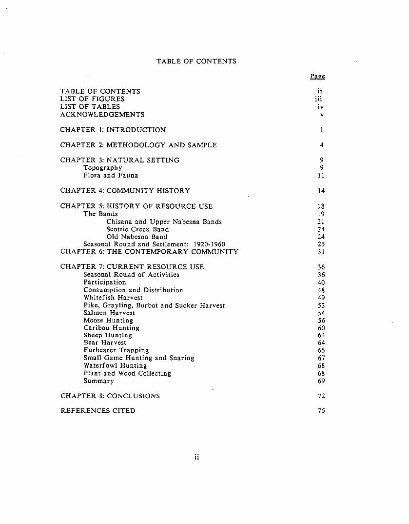
TABLE OF CONTENTS
TABLE OF CONTENTS LIST OF FIGURES LIST OF TABLES ACKNOWLEDGEMENTS
CHAPTER 1: INTRODUCTION
CHAPTER 2: METHODOLOGY AND SAMPLE
CHAPTER 3: NATURAL SETTING Topography Flora and Fauna
CHAPTER 4: COMMUNITY HISTORY
CHAPTER 5: HISTORY OF RESOURCE USE The Bands
Chisana and Upper Nabesna Bands Scottie Creek Band Old Nabesna Band
Seasonal Round and Settlement: 1920-I 960 CHAPTER 6: THE CONTEMPORARY COMMUNITY
CHAPTER 7: CURRENT RESOURCE USE 36 Seasonal Round of Activities 36 Participation 40 Consumption and Distribution 48 Whitefish Harvest 49 Pike, Grayling, Burbot and Sucker Harvest 53 Salmon Harvest 54 Moose Hunting 56 Caribou Hunting 60 Sheep Hunting 64 Bear Harvest 64 Furbearer Trapping 65 Small Game Hunting and Snaring 67 Waterfowl Hunting 68 Plant and Wood Collecting 68 Summary 69
CHAPTER 8: CONCLUSIONS 72
ii . . . 111 iv V 1
4
9 9
11
14
18 19 21 24 24 25 31
REFERENCES CITED 75
ii
LIST OF FIGURES
Figure 1. Location of, Northway
Figure 2. Tetlin National Wildlife Refuge and Game Management Unit Boundaries, Northway Area
Figure 3.
Figure 4.
Figure 5.
Figure 6.
Figure 7.
Figure 8.
Figure 9.
Figure 10.
10
13
Approximate location of former band territories of Northway residents 22
Seasonal round of resource harvesting activities for selected species reported by a sample of Northway residents 37
Percent of Northway sample households undertaking resource harvesting, 1983-84 41
Percent of Northway sample households participating in six major categories of harvest activities, 1983-84 44
Map of Northway sample household fishing areas, 1974-84 51
Map of Northway sample household moose hunting and vegetation gathering areas, 1974-84 57
Map of Northway sample household caribou, sheep, and waterfowl hunting areas, 1974-84 62
Map of Northway sample household trapping areas, 1974-84 66
. . . 111
LIST OF TABLES
Table 1. Northway Study Sample 5
Table 2. Northway Population and Households by Residence, 1984 33
Table 3. Northway Households by Ethnicity and Area, 1984 35
Table 4. Participation in Harvest Activities by Northway Sample Households, 1983-84 42
Table 5. Subsistence Harvest Levels for a Sample of Northway Residents, 1984-85 45
Table 6. Breadth of Harvest Activities and Socioeconomic Characteristics by Age of Northway Household Study Sample, 1983-84 47
iv

ACKNOWLEDGEMENTS
The author wishes to thank the residents of Northway for their
cooperation and assistance during this study. Appreciation is extended to
members of the Northway Traditional Council who endorsed the research and
who helped in the initial stages of data collection. Many people provided data on
various aspects of the research and review of the report draft, as well as
hospitality and friendship throughout. Special thanks go to Cora Demit for
translating during several interviews. Jim Jordan of Tanana Graphics expertly
drafted the final maps used in this report. Terry Haynes provided the research
design, as well as valuable editorial comments on the report drafts. Bob Wolfe
reviewed the final draft and his comments and insights are greatly appreciated.
Finally, Jean Harrison is to be thanked for processing the final copy of the
report.

CHAPTER 1
INTRODUCTION
This report describes contemporary and recent historic use of fish and
wildlife resources by residents of Northway, Alaska. Northway today consists
primarily of an Athabaskan population which formerly lived and subsisted in the
surrounding area, as well as some Alaska Natives from elsewhere in the state, and
non-Natives who have moved to the community since the early 1940s. The
discussion of resource use activities centers on land areas used, settlement
patterns, and seasonality of activities. A brief history of the community and an
overview of current residence patterns are also included.
The research objectives were designed to address four specific land use
planning and resource management issues in the Northway area. The first
objective was the documentation of uses of Copper River salmon by residents of
the Upper Tanana valley. This information was requested by the Board of
Fisheries to assess subsistence uses of Copper River salmon occurring in Upper
Tanana communities. Previous research conducted in Dot Lake by the Division
of Subsistence (Martin 1983), as well as public testimony, has indicated the
significance of Copper River salmon in certain Upper Tanana communities. As
discussed below, the Northway research further documents long-standing social
ties among Upper Tanana and Copper River residents, in which the trade and
distribution of salmon is manifested in ongoing relationships. A report
summarizing the uses of Copper River salmon in four Upper Tanana communities
was presented to the Board of Fisheries in November 1984 (Haynes, Case, Fall,
Halpin, and Robert 1984).
1
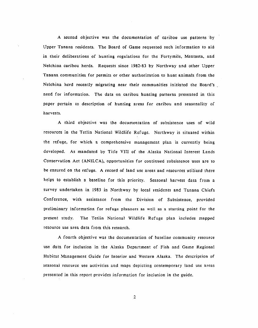
A second objective was the documentation of caribou use patterns ‘by
Upper Tanana residents. The Board of Game requested such information to aid
in their deliberations of hunting regulations for the Fortymile, Mentasta, and
Nelchina caribou herds. Requests since 1982-83 by Northway and other Upper
Tanana communities for permits or other authorization to hunt animals from the
Nelchina herd recently migrating near their communities initiated the Board’s
need for information. The data on caribou hunting patterns presented in this
paper pertain to description of hunting areas for caribou and seasonality of
harvests.
A third objective was the documentation of subsistence uses of wild
resources in the Tetlin National Wildlife Refuge. Northway is situated within
the refuge, for which a comprehensive management plan is currently being
developed. As mandated by Title VIII of the Alaska National Interest Lands
Conservation Act (ANILCA), opportunities for continued subsistence uses are to
be ensured on the refuge. A record of land use areas and resources utilized there
helps to establish a baseline for this priority. Seasonal harvest data from a
survey undertaken in 1983 in Northway by local residents and Tanana Chiefs
Conference, with assistance from the Division of Subsistence, provided
preliminary information for refuge planners as well as a starting point for the
present study. The Tetlin National Wildlife Refuge plan includes mapped
resource use area data from this research.
A fourth objective was the documentation of baseline community resource
use data for inclusion in the Alaska Department of Fish and Game Regional
Habitat Management Guide for Interior and Western Alaska. The description of
seasonal resource use activities and maps depicting contemporary land use areas
presented in this report provides information for inclusion in the guide.
2
Following chapters on research methodology and the natural environment
of the Northway area, two chapters briefly discuss the history of the community.
The first traces initial historic contact with local Athabaskan bands, and
describes the development of local infrastructure and settlement. The second
briefly examines the recent (1920-1960) history of resource use, describing
geographic areas used and seasonal patterns of harvest. These chapters provide a
context within which current resource use may be examined. Chapter 6 describes
the contemporary population, residence patterns, local community services, and
employment opportunities. Chapter 7 discusses contemporary resource use
patterns, specifically seasonal and geographic patterns. Household participation
in resource harvesting is treated briefly. Social patterns that are activated in
resource distribution in the community, and in the organization of task groups,
are also given brief analysis. The final chapter discusses one issue of
significance to local resource users identified during the course of field work,
that of competition for local resources with non-local harvesters.
3
CHAPTER 2
METHODOLOGY
Field research was conducted during June 1984, with brief follow-up field
trips in October 1984 and in August 1985, by one Division of Subsistence
researcher assisted by a bilingual translator from Northway. The study plan was
presented to and approved by the Northway Village Council in early June. Field
research began immediately. The Council secretary provided background
information on the community and assisted in identifying key active resource
harvesting households. The translator also accompanied the researcher to local
households to introduce the researcher and help explain the project objectives. A
local census (Alaska Department of Community and Regional Affairs 1984) was
provided by the president of Northway Natives, Inc., who, along with the Council
president and several other local residents, assisted the researcher in various ways
throughout the study period.
The primary data collection technique employed was systematic
interviewing, using both household survey forms and key respondent interviews.
Unstructured conversations also yielded important information. Observations
were made of whitefish dip netting, basket and canoe-making, and hide tanning.
Participant observation at a Copper River salmon fishing expedition with
Northway residents, a funeral and potlatch, a black bear butchering, and several
non-resource related occasions added further qualitative data. However, due to
the brevity of the fieldwork and the broad scope of the research objectives, data
collection relied heavily upon formal interviews.
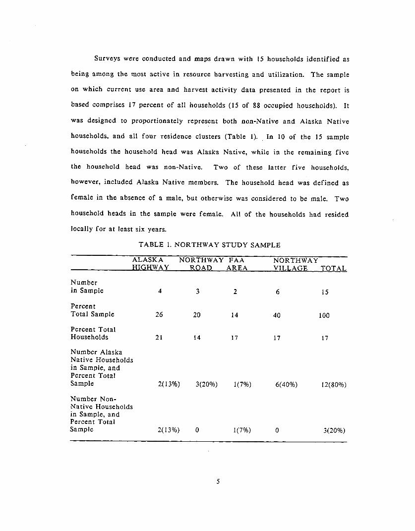
Surveys were conducted and maps drawn with 15 households identified as
being among the most active in resource harvesting and utilization. The sample
on which current use area and harvest activity data presented in the report is
based comprises 17 percent of all households (15 of 88 occupied households). It
was designed to proportionately represent both non-Native and Alaska Native
households, and all four residence clusters (Table 1). In 10 of the 15 sample
households the household head was Alaska Native, while in the remaining five
the household head was non-Native. Two of these latter five households,
however, included Alaska Native members. The household head was defined as
female in the absence of a male, but otherwise was considered to be male. Two
household heads in the sample were female. All of the households had resided
locally for at least six years.
TABLE 1. NORTHWAY STUDY SAMPLE
ALASKA NORTHWAY FAA NORTHWAY HIGHWAY ROAD AREA VILLAGE TOTAL
Number in Sample
Percent Total Sample
Percent Total Households
Number Alaska Native Households in Sample, and Percent Total SampIe
Number Non- Native Households in Sample, and Percent Total Sample
4 3
26 20
21 14
2(13%) 3(20%)
2(13%) 0
2 6 15
14 40 100
17 17 17
1(7%) 6(40%) 12(80%)
1(7%) 0 3(20%)
5

Eleven households consisted of nuclear families, that is, a couple and their
children or two adult siblings. Three households were extended, containing three
generations (grandchildren) and one household contained a single individual. The
mean household size was five persons, as was the average size of the nuclear
family households.
By focusing on the most active resource harvesting households, the study
attempted to illustrate general resource use patterns in the community. However,
not all active resource users were contacted. Consequently, this report may not
include all important aspects of resource use in Northway. The geographic
resource use areas, particularly furbearer trapping areas, should not be considered
a complete depiction of areas used by the community. Interviews were also
conducted with twelve key respondents. These interviews provided a range of
data used in this report to describe historical resource use and community
settlement patterns, as well as data on the current seasonal round and social
relationships as discussed above. Numerous casual conversations with other
community residents contributed significant pieces of data on the above topics as
well.
Respondents were interviewed individually at home, with other household
members often present and contributing some hunting, trapping, fishing, and
gathering areas on USGS topographic maps (1:250,000 scale). In most cases, the
maps present the respondent’s household use area as a whole, while in a few cases
the mapped data may be limited to the respondent. One respondent, in addition
to an individual household map, drew a map of the general community’s use area,
which was used for comparison with final composite maps.
The time frame mapped covers the ten-year period 1974-1984 and was
selected to depict a contemporary period of land use. It is possible that a larger
6
use area may have been documented with a longer time perspective. The
respondent’s individual map biographies were combined into composites for such
major resource categories as moose, caribou, sheep, waterfowl, furbearers, fish,
and plants and wood. As is stated on each map in the report, the area depicted is
partial and of a limited time period. A dynamic system of land use prevails here,
in which individual use areas expand and contract over time. The mapped areas
in themselves do not represent a judgment of “importance” of particular areas.
A survey questionnaire was administered during the mapping sessions.
One respondent usually answered the questions. Other household members were
often present and at times contributed information. The format of the questions,
however, allowed one individual to answer for the household. Emphasis in the
survey was placed on the most current years’ harvesting activities, seasonal round,
participation rates, and harvest levels (June 1983-May 1984). Information on
social aspects of resource use activities (work group composition, distribution, and
consumption patterns) was requested for some of the major resources (moose,
trapping, salmon, and whitefish). Basic household employment and economic
status information was obtained on most surveys. Several residents not contacted
as survey or mapping respondents provided background information outside the
context of household surveys on topics concerning the local history of resource
use and settlement, traditional intra- and inter-community social ties, and
genealogy. These respondents also provided additional detail on current resource
use activities and patterns.
Names were not used on the survey forms in order to increase
confidentiality. However, social relationship and age were requested to provide
information on household composition, work group composition, and distribution
of major resources. Anonymous data are of limited value for analyzing social
7
aspects of resource use, since it is impossible to cross-reference unnamed
respondents. Ambiguity or duplication is possible without positive identification
of individuals. Additional interviews, particularly those done during the
subsequent field trips in October 1984 and August 1985, yielded genealogical data
which helped to clarify social patterns.
The relatively short duration of data collection in the field and reliance
upon structured household interviews contribute to the brevity of this report.
The reader is reminded that the report is neither comprehensive in scope nor in
detail. Further research is required to amplify relevant topics, such as resource
distribution and exchange patterns and annual harvest levels. However, the
report has been reviewed by Northway residents, and approved as a document
that generally reflects local fish and wildlife use patterns.
8

CHAPTER 3
NATURAL SETTING
TOPOGRAPHY
Northway’s hunting and fishing areas lie in the subarctic boreal forest of
east-central Alaska (Fig. 1). Northway’s areas fall within a high broad valley
(1800 ft. elev.) of the headwaters of the Tanana River, and encompasses the hills
and mountains bordering the valley, including the Nutzotin Mountains on the
south and the Tanana Hills to the north. The valley is bounded on the east by
hills between the Nutzotin foothills and the Tanana Hills, and on the west by the
Mentasta Mountains, which constrict the valley by their northward extensions.
The Nabesna and Chisana rivers, flowing north and northwestward across
the valley from glaciers in the Nutzotin Mountains join to form the Tanana
River, which flows northwest out of the study area. Numerous clear streams
enter the rivers from mountain drainages or flow across the valley. Lick Creek,
flowing near Pickeral Lake, and the Cheslina River flow into the Nabesna River.
Mirror, Scottie, Desper, Gardiner, Stuver, Moose,. and Mark creeks are important
tributaries of the Chisana River. The Ladue River drains a southern portion of
the Tanana Hills within the study area. There are numerous lakes and ponds in
the valley basin. A series of hills (the Black Hills) interrupts the sloping grade of
the valley for several miles (Fig. 1).
Several classified ecosystems (Vierick and Little 1972) occur throughout
the area, supporting a variety of fauna1 and floral species. Closed spruce-
hardwood forests cover lower elevations of the hills and occur interspersed

I \ Tettin L
I Nabesns
Fig. 1. Location of Nortkway
10
throughout the valley with lowland spruce forests and open bog. Birch, aspen,
white spruce and black spruce comprise these forests. Lowland spruce forests
(predominately black spruce) share the valley basin with treeless bogs and many
lakes, ponds, and streams. Thickets of alder and willow crowd the shores of
ponds and streams where drainage allows. Tundra covers the upper elevations of
the Tanana Hills and the Nutzotin Mountains around the headwaters of the
rivers, with low heath, shrubs, and dwarf herbs, or sedges and tussocks.
The climate is notably continental, with very cold winters and warm
summers. It is one of the coldest areas in the state, with recorded temperatures
ranging between 91 degrees and -72 degrees Fahrenheit. Precipitation is slightly
in excess of 10 inches per year, with snowfall averaging 30 inches per year
(Alaska Department of Fish and Game 1978, Darbyshire and Associates 1980).
FLORA AND FAUNA
Large mammals in the area include moose, Dal1 sheep, bear, and barren-
ground caribou, the latter primarily of the Fortymile Herd. Small numbers of the
Fortymile herd winter in the vicinity of the upper Tanana and lower Chisana
rivers, and larger numbers winter in the Ladue River drainages. The Fortymile
herd was more prevalent in the valley prior to the 1930s when the herd was
reported to be especially large (Davis, Shideler, and LeResche 1978). The
Nelchina herd from the upper Susitna drainage to the southwest has been
wintering in varying numbers in the study area since the winter of 1982-83. Part
of the Mentasta herd to the southwest of the study area has wintered in the study
area since 1983-84 (United State Department of the Interior 1985). The small
Chisana herd remains among the headwaters of the White and Chisana rivers in
11
the Nutzotin Mountains. Dal1 sheep occur in the Nutzotin Mountains and were
traditionally hunted there. Black bear are relatively numerous in the forests;
grizzly bear are seen in the open spruce and alpine areas. Moose are found
throughout the study area. Waterfowl inhabit the lakes and streams in the spring
and fall. These include many duck species, Canada, snow, and white-fronted
geese, trumpeter and whistling swans, sandhill cranes, and Arctic and common
loons. Grouse (primarily spruce and ruffed) and -willow ptarmigan occur
ubiquitously. Snowshoe hare and porcupine also inhabit the study area. Two
species of whitefish (round and humpback), burbot, northern pike, Arctic
grayling, and suckers are the predominant fish of the area. Chum salmon have
been known to occur in the Chisana River and Scottie Creek, but are relatively
tare. Local furbearers include muskrat, beaver, marten, mink, otter, wolverine,
red fox, coyote, wolf, and lynx. Beaver are found throughout the local region,
although historically have occurred in relatively small numbers (Murray 1961).
Muskrat, on the other hand, are abundant. Many species of herbaceous plants
occur in the area, several of which are picked for their greens, stalks, or roots.
Mushrooms and a lily root “cached” by muskrat are also collected. Numerous
berries occur in the area and are harvested annually. The Northway community
and a large portion of the Northway village corporation land selected under the
Alaska Native Claims Settlement Act lie within the Tetlin National Wildlife
Refuge. Figure 2 depicts the refuge area as well as local game management units
administered by the Alaska Department of Fish and Game.
12
0 A I 1 1 0 10 20 Kilometers
GMU 20 E
GMU 11
FiQ.2. Tetlin National Wifdlifa Refuge and Game Management Unit Boundaries,
Northway area
13
CHAPTER 4
COMMUNITY HISTORY
This section summarizes the contact history of the uppermost Tanana
River area near what is now Northway, and is derived principally from
McKennan (1959) and Cole (1979). Secondary sources of information include
local key informants, Andrews (1975), Guedon (1974), Haynes et al. (1984), Pitts
(1972), and Shinkwin, Aigner, and Andrews (1980).
Historic sources confirm the presence of Upper Tanana Athabaskan
peoples residing on the Chisana and Nabesna drainages at the time of direct
white contact in the 1880s. They occupied areas around the upper and lower
Nabesna, and upper and lower Chisana, (including Scottie Creek) rivers.
Elements of western technology and material culture diffused into the area prior
to the mid-l800s, although almost no permanent settlement by non-Natives
occurred until early in the 20th century. Even then, only a few non-Natives
spent any length of time in the area until the early 194Os, when Alaska’s military
buildup during World war II attracted thousands of newcomers to the state.
.
The presence of non-Native trappers, traders, explorers, and prospectors on
the Chisana or Nabesna rivers had not been documented until the very end of the
19th century. Prior to that time, during the last half of the 19th century, some
local Athabaskans maintained contact with trading posts on the Yukon,
Fortymile, and Stewart rivers, and there are records of some travel within the
genera1 Upper Yukon-Tanana region by traders or exploratory parties. For
example, there is a record of an 1870s crossing of the Tanana Hills by two
14
traders, Harper and Bates, from Eagle on the Yukon River to a point some miles
below Tanacross on the Tanana River. They continued downriver from there.
Older Northway respondents recall using a trail to Dawson in the early
20th century to trade, prior to the establishment of local trading posts in the
upper Tanana drainage. The Fortymile River to the north and the Nizina River
in the Copper River basin attracted a number of prospectors in the late 1800s.
The Nabesna and Chisana rivers apparently did not, although McKennan (1959)
surmises that some prospectors probably passed through the area. Cole (1979)
notes that prospectors had penetrated the upper drainages of the Nabesna River
in the late 1800s.
Lt. Allen’s 1885 exploration of the Copper and Tanana rivers (cf. Allen
1887) brought him to the west of the study area, through Suslota Pass in the
Mentasta Mountains, and down the Tetlin River to the Tanana. He remained at
Last Tetlin and Tetlin for four days before heading down the Tanana River to
Lake Mansfield (McKennan 1959, Cole 1979). Apparently, there are no further
records of explorations into Upper Tanana country until 1898 and 1899 when
Brooks and Peters made two trips into the upper Chisana and Nabesna drainages
via the White River in Canada, once continuing down the Chisana River to the
Tanana, and once heading southwest into the Copper River drainage. Brooks’
report constitutes the first known written account of the uppermost Tanana River
(Cole 1979).
Quartz gold was discovered on the upper Nabesna drainage in 1899, and
copper deposits were found there in 1902. Prospectors continued to work in the
Upper Nabesna area during the Fairbanks gold strikes of 1903-04, and until the
Chisana gold stampede of 1913. The short-lived gold rush brought in prospectors
by the hundreds, many crossing overland from the Tetlin River to the Chisana
15
River, others ascending either the Nabesna or Chisana rivers from the Tanana.
The first freight boat came up the Nabesna River in 1905 approximately 15 miles
and off-loaded 40 tons of supplies to be carried upriver to the gold mines on the
upper Nabesna (Cole 1979).
Several trading posts were managed in the area, beginning in 1909 and
1910 with excursions by a Captain Northway from Fairbanks to the lower
Nabesna River. Throughout the Chisana stampede of 1913-14 various supply and
steamboat off-loading stations were active on the upper Tanana, Nabesna, and
Chisana rivers, and after 1914 the local fur market was apparently well
established (cf. Cole 1979). For almost 40 years trading posts or stores existed
intermittently at the Chisana mine on Bonanza Creek, the head of Scottie Creek
(Canada), and near the mouths of Gardiner, Mirror, and Moose creeks. Four posts
were located over the years near a camp site of the lower Nabesna River people
near the present community of Northway. The last of the trading stations in the
area (Moose Creek) was disbanded after the death of the owner in 1953.
Sometime prior to 1933 a large airstrip was constructed at an upper Nabesna mine
in the Nutzotin Mountains, and in 1933 a road was built into the mine area from
the Glenn Highway.
Two camps of the lower Nabesna River people, near which the four
trading posts noted above were located, became construction sites for schools and
churches. In the early 1930s a Tetlin school teacher held classes in a tent at a
fish camp (K’ehthiign, or “Fish Camp”) during the summer. In 1939-40 a Bureau .
of Indian Affairs school was built at a camp on the west bank of the Nabesna
River (“Old Nabesna”). An Episcopal church was established at Old Nabesna, and
later replaced by a Pentecostal Holiness church and a Roman Catholic church.
16
Major visible changes occurred suddenly in the early 1940s. The Old
Nabesna settlement moved to its present location along the east bank of the
Nabesna River to avoid river erosion. The Alaska Highway along the northern
edge of the valley was completed in 1942, and an airstrip ,was constructed
approximately seven miles south of the highway and two miles from the Nabesna
village. A graded road connected the airstrip and village to the highway. A post
office was established in 1941, the village name was changed to Northway, and a
state school, replacing the BIA school, was built near the new Federal Aviation
Administration and airport station. Settlement of the other Nabesna and Chisana
groups at the new Northway Village occurred during this period, and is discussed
further in the next section. After the establishment of state school districts, the
community census encompassed the school district boundaries, including the
village, the Airport area, residences along the seven-mile section of the Northway
Road, and a 14-mile section along the Alaska Highway. The population has
grown from roughly 100 residents in the early 1940s to over 300 by 1980. The
highway provides access to several neighboring communities and to Fairbanks,
250 miles away.
17
CHAPTER 5
HISTORY OF RESOURCE USE
This section discusses the resource use areas, seasonal scheduling of harvest
activities, and certain aspects of settlement patterns of the local Athabaskan
bands immediately prior to the establishment of Northway as a permanent, year-
round community. Many contemporary residents are descendants of these bands.
As noted in the previous chapter, the recent .history of the area includes an
integration of in-migrants into the traditionally Athabaskan area. The following
discussion of the Athabaskan land use patterns is intended as a vehicle for
broadening the understanding of local resource use patterns today in the context
of a variety of users.
The time period reported here includes the years between about 1920 and
1960, when groups derived from former Athabaskan bands continued to live --.----
seasonally in semi-permanent camps throughout the area, yet increasingly
gathered year-round near what would become present-day Northway Village.
Most had settled at Northway and other Upper Tanana communities by 1960. It
is also a time remembered clearly by many residents today, some of whom
experienced the period first-hand, and others who can relate stories learned from
elders. Some older respondents provided information on activities extending back
to the late 1800s. Although this constitutes a minimal part of the field data and
is not examined here, it could serve as a comparison of these previous years to
more recent history. Discussions of early Upper Tanana culture can be read in
Guedon (1974), McKennan (1959, 1969a, 1969b, 1981), Pitts (1972), Rainey (1939),
and Vitt (1971).
18
McKennan (1981:566) considers the years from 1920 to 1960 as constituting
a major transition period in terms of settlement and land use patterns for the
Upper Tanana area. Field data from Northway generally bear this out. In the
192Os, the Old Nabesna camp on the east bank of .the Nabesna River had
reportedly been in use for two generations by members of the Old Nabesna band.
During the 1920s and 1930s this site was increasingly used almost year-round by
families who built log cabins in which elders and children stayed during hunting
and trapping periods, and to which the families returned after fishing at sites
near Old Nabesna, including Fish Camp. The trading posts established near this
camp also encouraged settlement and drew members of other contiguous bands to
trade. The Old Nabesna camp became a semi-permanent village (cf. McKennan
1969b:336). After 1940 employment opportunities in construction jobs as well as
the opportunity to attend the local school attracted families to the settlement. By
1950 a few non-Native and Native in-migrants began entering the community.
Native settlement at the Northway Village increased as people moved in from the
upper Nabesna and mid- to upper Chisana rivers, and a few from Ketchumstuk
and Tetlin areas. The remaining members of the last outlying band moved to
Northway permanently in about 1960.
THE BANDS
A central Alaskan Athabaskan hunting and fishing band of the hundred
or so years prior to modern times (pre-1940) is defined as a small (population 20-
75), egalitarian, cooperative, and interrelated group inhabiting seasonal
settlements within a common territory (cf. Damas 1969, Leacock 1982, VanStone
1974). Occupied territory was used collectively by band members, although
19

degrees of individual ownership of particular sites or structures, such as caribou
fences, may have existed in the Upper Tanana region (McKennan 1969b:lOl).
McKennan (1969b:lOO-101,104) suggests that whitefish weirs also necessitated
collective band efforts in their operation and maintenance, although several weirs
closely situated might each be operated by groups of one to three families.
Marriage and kinship ties bonded members of a local band to one another as well
as to contiguous bands within a region. The above general definition of a “band”
as a socioterritorial grouping applies to a post-contact historic period identified
as the Contact-Traditional period between roughly 1850 and 1940 in the North
American subarctic (Helm, Alliband, Birk, Lawson, Reisner, Sturtevant, and
Witokowski 1975).
Local oral history indicates the presence of four local bands of Upper
Tanana-speaking Athabaskans in the Nabesna and Chisana river drainages prior
to 1960. The bands comprised individuals related by continuous consanguineal or
affinal ties camping together or near each other while fishing for whitefish in
the summer, then dispersing to hunt and trap in large but defined areas
surrounding the fish camps during the fall, winter, and spring. Hunting or
trapping camps consisted of one or more families and in some cases were located
at fishing camps. Each band had a “chief,” a respected man selected by elders for
hunting ability and generosity. Trails within a band’s territory were the property
of a chief. Permission had to be granted for cross-territorial use by local bands.
The bands in the Northway region are referred to by Northway residents today as
the Scottie Creek, Chisana, Old Nabesna, and Upper Nabesna villages. In this
report they are referred to as bands, to differentiate them from the contemporary
village. The Tetlin and Last Tetlin bands, documented by McKennan in 1930 and
whose members today reside primarily in Tetlin, as well as members of bands
20
now living in Tanacross, used “slightly different country” to the west of the
Northway bands. They are not discussed here, although they occasionally shared
resource harvesting areas with the Nabesna and Chisana river bands.
Geographically, the area used by the four bands prior to settlement in
Northway encompassed the entire lengths of the Chisana and Nabesna rivers, as
well as the head of the White River, Snag Creek (Canada), parts of the Ladue
River and its tributaries, and the expanses of land between the rivers including
tributary streams and lakes. Individual band territorities represented usual or
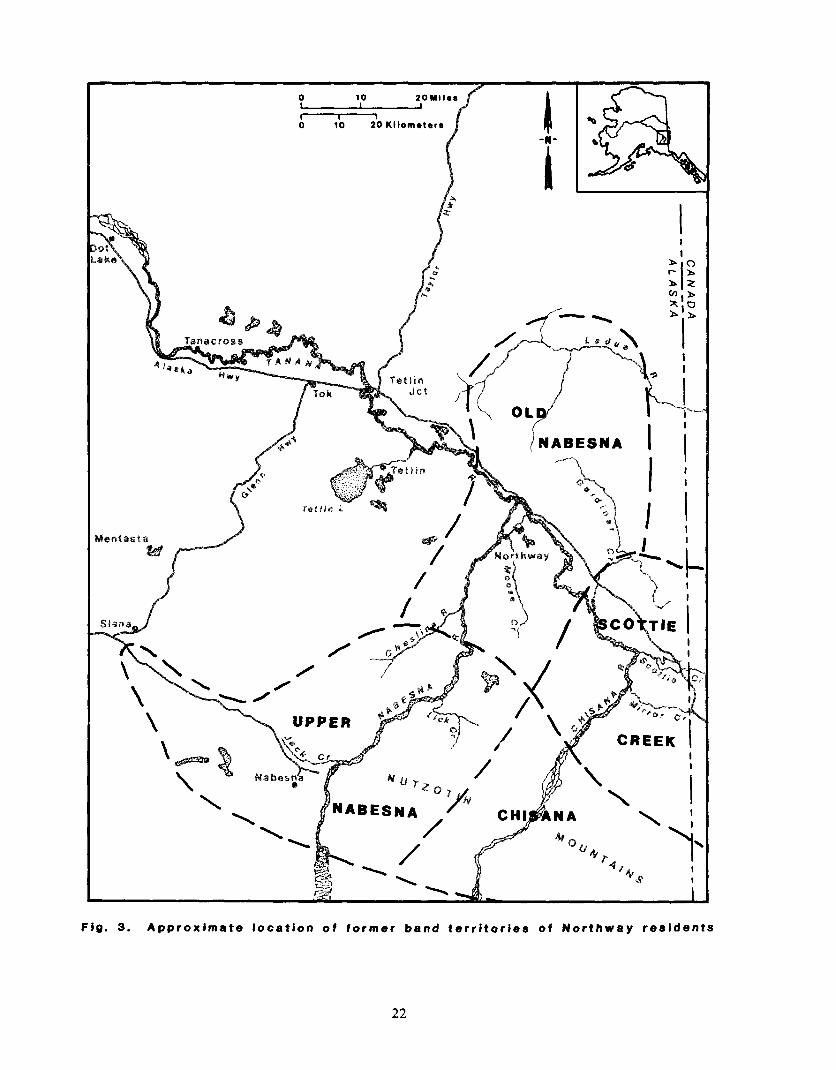
normal areas of use. Figure 3 depicts approximate band territories as described
below.
Chisana and Upper Nabesna Bands
The Upper Nabesna and Chisana bands occupied the headwaters of the
Nabesna and Chisana rivers and their tributaries. On the Nabesna River, the
local people travelled from the vicinity of the Nabesna Glacier downstream to
Pickeral Lake and its feeder streams at the foot of the Nutzotin Mountains, and
down the Nabesna River to approximately Lick Creek. They ranged west along
Jack Creek and the head of the Cheslina River, including the mountain valleys,
streams, and lakes there, and west to Slana and Batzulnetas. This is an area of
approximately 40 miles along the Nabesna River and 20-30 miles west of the
river. Streams and trails through the mountains east to the head of the Chisana
River were traversed. The Chisana River was occupied approximately from its
head at the Chisana Glacier to somewhat below the foot of the Nutzotin
Mountains, approximately 30-40 miles. The head of Snag Creek and the White
River to the southeast of the Chisana were apparently included in the use area.
21
0 10 20 Kilomotors
I I
ABESNA I I I
\ I- I
/ \ CREEK \
I
\ I
I
Fig. 3. Approximate location of former band territories of Northway residents
22

Documentation for the use area of these bands derives from interviews by James
Kari in Nabesna (pers. comm., 1985), Johnson (1964), McKennan (1959), Reckord
(1983b), and field data from Northway.
Whether or not this entire area was inhabited by one or two bands remains
questionable. McKennan (1959) has documented the presence of only one band
for this area, which he terms the Upper Nabesna-Chisana band. He postulates
that the 1913-14 Chisana gold stampede, in which thousands of miners inundated
the resource use area of the former Chisana band, depleted the resource base
enough to necessitate combining the Chisana and Upper Nabesna use areas. Such
merging of bands for periods of years in response to ecological changes may be
considered an example of a common social adaptation displayed by subarctic
bands (McKennan 1969b:104, 1981:566).
However, local residents today refer to the Chisana people of the mid-20th
century as a group which was identified with a village on the upper Chisana
River, had a “chief”, and used a trapping area that extended in part down the
Chisana River to a point adjacent to that of the Scottie Creek band to the north.
At this time many band members worked as loggers and hunters for miners in the
upper Chisana drainage. As an indication of band identities prior to the 1913
stampede, Cole’s reference (1979) to a statement by Moffit and Knopf (1910)
indicates the presence of a distinct group on the upper Chisana River:
The Batzulnetas and Nabesna natives rely on the white man for a considerable portion of their food, but the Chisana natives are more independent. Their more isolated position has brought them less in contact with white men, and they have maintained their own manner of living to a greater extent. They depend almost entirely on game for food and lay up a good supply each fall for the winter’s needs (Moffit and Knopf 1910:14).
During the mid-20th century, movement of the Chisana people seasonally
to Scottie Creek as well as to Upper Nabesna is remembered, and apparently was
23
very common. Reciprocal movements were also made by the other bands. These
visits were made for social purposes as well as for obtaining resources, and such a
pattern is evident among all bands in the study area.
Scottie Creek Band
The Scottie Creek band occupied the mid-Chisana River, from
approximately the base of the Nutzotin Mountains to Gardiner Creek, and
included Mirror Creek, Scottie and Desper creeks, lower Stuver Creek, and the
Island Lake area, as well some area to the east in Yukon Territory. This use area
extends approximately 30-40 miles north-south, and at least 20 miles east-west.
The band maintained camps on lower Scottie Creek and Desper Creek (“High
Cache”) during the mid-20th century.
Old Nabesna Band
The Old Nabesna band inhabited the lower Chisana River from Gardiner
Creek to its mouth, and the lower Nabesna River from approximately the
Cheslina River to the mouth, and the confluence of the two rivers and the
beginning of the Tanana River. Members of this band travelled northward to the
upper Ladue drainage, and utilized the lakes and streams south to the Black Hills
east of the Nabesna River. This constitutes an area approximately 50 miles
north-south and 25-30 miles east-west. Two camps on the Nabesna River, called
Nabesna village or Old Nabesna, and Dry Creek, as well as several fish camps in
the lower Nabesna and Chisana river area were occupied by this band in the mid-
24
20th century. Data for the Scottie Creek and Nabesna band areas are derived
from local field interviews.
SEASONAL ROUND AND SETTLEMENT: 1920- 1960
The seasonal pattern of resource harvest activities for the study area
generally resembles that of other interior Alaskan Athabaskans (Andrews 1975;
McKennan 1959; Clark 1981; Nelson 1974; Reckord 1983a; Shinkwin and Case
1984, VanStone 1974). Fishing occurred primarily in the summer, large and small
game was hunted heavily in the fall, trapping was done in the winter, and spring
was a time for trapping aquatic furbearers, hunting waterfowl, and preparation
of fishing gear. Scheduling was based, in part, on the availability and seasonal
quality of game, plants, and fish. A broad spectrum of resources had to be
exploited in order to maintain a constant food supply, although some items were
obtained from local trading posts or stores during these years and incorporated
into the diet. Harvesting was efficient and productive. In general, there were
preferred seasons in which to harvest resources, but food was sought at any time
if it was needed. Seasonal band mobility within an area was necessary in order
to locate often widely dispersed game resources.
In striking contrast to most Athabaskan groups outside the Upper Tanana
region, local people had no direct access to salmon. The closest runs occurred on
the upper Copper and upper Yukon rivers. Local fishing targeted whitefish
instead. Salmon was obtained by travelling overland to, or trading with people
from, the Copper River.
Data on the 1920-1960 seasonal round pattern were elicited from former
members of three of the local bands. They each recounted similar patterns of
25
seasonal resource use, but their descriptions reflect differences in the resource
base and seasonality of harvest between the band use areas. The following
account is a composite of the three-band descriptions, except where particular
band patterns are noted.
Large quantities of whitefish were harvested in late June, and again in
August and through October. Fishing was done with dip nets or conical traps in
small clearwater streams, and occasionally with set gill nets in lakes. Field data
on the initial use of set gill nets indicates their use by the 1920s. Respondents
report learning to weave gill nets of twine from local traders, and occasionally
bought them.
One respondent notes the use of commercial set nets by 1950. McKennan
(1959), however, states that Nabesna people did not make and were not using set
gill nets when he was in the area in 1929-30. Weirs were built for dip nets across
streams in order to channel fish as they swam from lake to river, and included
platforms on which fishermen stood while dipping the net or trap. Weir locations
were used repeatedly for many years. One respondent describes a first visible
wave of whitefish migrating downstream that marked the beginning of the
fishing season. Hundreds of fish were netted in a few hours during a heavy run
when several men operated two or three nets in rotation, emptying a full net
while dipping another. Fish were cut and hung to smoke and dry at once,
children carrying loads of fresh fish to women at family cutting tables until
everyone had enough. People smoked and dried their fish at the camps. A
portion of the processed fish was carried to a winter camp location. The rest was
cached for later retrieval in the fall and winter, for use at camps which served as
a winter base of activity, such as Scottie Creek and Fish Camp.
26

Large camps located at fishing sites accommodated several families, or the
entire band. Each band maintained at least one fishing site. If there was only
one site, it was used cooperatively by everyone. Some bands at times maintained
three or more sites (as was the case with the Nabesna band) used by groups of
households. There was constant movement of individuals between sites,
allowing for visiting, as well as exploiting larger fish runs and enjoying the
variety of subtle flavor differences between fish from different locations.
Members of the Old Nabesna band maintained at least six dip netting sites
during these years, all but one (Tenmile camp on the lower Chisana River) within
a radius of 5 miles of each other, and three of which were used in 1983-84.
Today they are referred to by geographic place names: Fish Camp (K’ehthiign),
Moose Creek (two sites), Mark Creek, Charlieskin, and Tenmile camp.
Recognition is given at most sites to particular men who are said to have either
“founded” the site, or lived there with their families more often than at others.
However, a traditional system of private ownership of fishing sites, such as that
reported by Clark (1981:585) for the Koyukon Athabaskans, or by McKennan
(1969b:lOl) for caribou fences is not assumed to be operative here for fish weirs.
Respondents report a communal use pattern for each site despite the association
of family names. Further investigation would clarify local ownership patterns.
Plants such as wild rhubarb, labrador tea, birch bark and spruce roots for
baskets, and various green leaves were gathered during the summer. Hare,
porcupine, marmot, ground squirrel, moose, and bear were also harvested
occasionally during the summer months.
Activities occurring in August after some fish had been dried and stored
included hunting for moose, duck, geese, and porcupine, snaring of hare and
grouse, muskrat trapping, berry picking and the digging of “edible roots”. Groups
27
of one or two households would “move out in the woods” with pack dogs to hunt
moose, setting up temporary camps as a base for hunting, butchering, and drying
the meat. Moose traditionally was dried in August before cool damp September
weather inhibited drying. Chisana band members often travelled to Scottie Creek
to hunt moose and ducks, and to fish. A late whitefish run occurred in the
Scottie Creek area through October which drew members of the other bands.
Some members of the Old Nabesna band moved to the Tenmile Lake fish camp to
continue fishing while hunting moose. During the period between 1920 and 1960
an increasing number of people, usually elders and children, stayed in a main
camp, either the fish camp or another “winter camp,” while others hunted. Meat
was packed back to the camp with the aid of other band members and dogs. It
was shared among those who helped pack, as well as given by the hunter to non-
harvesting households. Data on social relationships of people involved in the task
groups are minimal, but in one example, primary kin constituted a cooperating
work group.
Hunting for sheep or caribou followed the fall moose hunt. In September
before deep snowfall in the mountains, the Chisana and Upper Nabesna bands
moved back into the high Nutzotin drainages and passes from which they hunted
sheep. Some members of the lower river bands went also, harvesting and caching
moose on the way.
From September until later in the fall (November) when the Fortymile
caribou herd passed through the lower Chisana drainage heading southeast into
Canada, concerted caribou hunting took place, and again members of the Chisana
band came down to Scottie Creek to hunt. Members of the Old Nabesna band
moved north into the Ladue River hills to camp and hunt caribou. Caribou was a
dietary mainstay, contributing, according to one respondent, the same amount to
28
the diet as moose. McKennan (1959:32, 47) observed that caribou constituted a
greater proportion of the diet than moose in 1929-30.
Trapping occurred throughout the winter along with continued moose and
caribou hunting. Trapping areas were well defined and apparently conformed
with band territories. Hunting and trapping generally were accomplished within
band territories by band members, but there existed a large measure of mobility
between bands by individuals and families. To paraphrase one respondent: “We
(Northway people) are all the same people, but have different fish camps.
Everyone walks.” The settlement pattern was slightly less dispersed than it was in
the fall. Families remained at winter base camps while men or women and
children trapped or hunted. Camps were occupied by single families, or two or
more families at once. After 1940 more families of the Old Nabesna band began
to stay at Northway village or Fish Camp during the winter so children could
attend school.
The spring months (April through early June) included occasional harvests
of moose, some late fishing through the ice, and hunting of waterfowl and egg
collecting. In addition, caribou were hunted as they migrated northeast in April
or May. Muskrats were trapped in March and then hunted after breakup until
early June. Bark was collected as the sun warmed the trees in May. Spring black
bear were sometimes harvested, and whitefish dip nets were placed and operated
at weirs beginning about mid-June. Game tended to be difficult to locate in the
spring, and harvest levels were often small. A diversity of species was hunted
then, as one respondent notes: they sought “everything that comes to life” in the
spring.
According to Pitts (1972), the changing pattern of caribou migrations
which left the study area depleted of caribou required adjustments by families
29
after the 1940s. The local population had to focus more attention on fur trapping
than on hunting, and on trading furs at local posts for supplies. Field data
indicate an increased effort on moose hunting after this time. During this period
in general, local men were often hired to hunt for mining camps or to work in
logging operations in the upper Chisana drainage. After the 194Os, men were
hired to work seasonally on local highway construction projects, which generally
took them away from summer fishing, but allowed time to pursue winter harvest
activities.
After 1940, with the establishment of schools, families tended to stay
longer in the Northway vicinity, attempting to incorporate school schedules into
their seasonal patterns. One family, for example, sent a child to school while
both parents trapped and hunted and an elder daughter took charge of other
younger siblings. Another respondent who was of school age in the 1950s
remembers leaving the village and school in April to go to Fish Camp with her
family. Automobiles and snowmachines were not common until more recently
(post-1960). Their advent and general use resulted in greater mobility to and
from resource use sites, especially fishing sites, such that fish camps near Old
Nabesna were no longer used as seasonal residences. However, until the 195Os,
foot travel with pack dogs remained prevalent and more time was spent in
resource pursuits away from the main village than is currently.
30
CHAPTER 6
THE CONTEMPORARY COMMUNITY
The Northway population today is diverse and dispersed, with residences
situated adjacent to a 14-mile stretch of the Alaska Highway, along a 7-mile
state-maintained graded road, in Northway village on the Nabesna River, and
near the airstrip and Federal Aviation Administration (FAA) station. A 1984
local census indicated a population of 334 residents (Alaska Department of
Community and Regional Affairs 1984). This is approximately a 43 percent
increase over both the 1970 and 1960 U. S. Census counts of 234 and 237,
respectively. In 1950 the U. S. Census recorded 196 residents. Between 1940 and
1950 the population almost doubled, from 108 in 1940 to 196 in 1950 (Darbyshire
and Associates 1980, Haynes 1984). This probably reflects the effects of local
airport and highway development in the early 1940s.
The FAA station area includes an international airstrip and customs
office, a lodge and restaurant, a store, bar, gas pump, post office, and fire station.
The school, a modern (1977) building housing grades K-12, is a mile from the
FAA area. Catholic and Pentecostal Holiness churches serve the community from
Northway Village. The village has a community center containing a clinic,
meeting room, and a counselor’s office. The Alaska Highway area includes two
gas stations, garages, and lodges, as well as a store, car wash, laundromat, and
craft store. The Native corporation (Northway Natives, Inc. or Naabia Niign,
Ltd.) and Alaska State Troopers have headquarters along the highway. Northway
Natives Inc. operates four rental apartments at the Northway Road junction, as
well as the aforementioned laundromat and craft store. The community supports
31
a uniformed softball team and a volunteer fire and emergency medical services
department.
At the time of the study, employment opportunities in Northway included
seasonal jobs in construction and firefighting, as well as some part- or full-time,
seasonal or year-round jobs in social service, administration, clerical work,
maintenance, and services (that is, lodge, restaurant, stores, service stations, post
office). A small number of jobs were available seasonally to teenagers, such as
gas station and store attendants, and jobs offered through the Neighborhood
Youth Corp (NYC) program. In addition, the Northway school enlisted
approximately 23 persons in full- or part-time employment. Five privately- or
corporately-owned businesses employed some local residents as store clerks, gas
station attendants, clericai staff, and construction and maintenance workers.
State or federal monies supported other positions, mainly those in the social
services field. A few positions were filled by seasonal residents, such as a Tetlin
National Wildlife Refuge biologist who supervised two local NYC employees.
As an indicator ‘of employment types, all sample households providing
employment or income data (n=14) had at least one member who earned cash
either through wage employment (11) or from craft and fur sales (3) during the
study period. One respondent was a full-time teacher. Five additional
households had members employed at the school. Five households had members
employed in seasonal construction or maintenance positions. Five households
included members who worked in social service positions (that is, health aides,
senior citizens aides, counselor). One respondent was employed in a clerical
position.
Five of twelve responding households listed income as less than $10,000
per year, and four others reported incomes between $10,000 and $20,000 per year.
32
The three non-Native households in the sample had incomes greater than $30,000
per year, and included several employed members. The Federal Income Taxpayer
Profile reports the 1982 average taxable income as $13,304 for the Northway
community (Alaska Department of Revenue 1985).
The resident population of Northway at the time of the field study in
June 1984 was 312, slightly less than the number accounted for in the 1984
census. Eighty-eight households were occupied in June 1984. As is shown in
Table 2, the community comprised four spatially discrete residential groupings:
the village (36 households, or 41 percent), the FAA area (12 households, or 14
percent), the Northway Road group (21 households, or 24 percent), and the Alaska
Highway (19 households, or 22 percent). All but one of the 36 households in the
village included Alaska Natives, most of whom were originally from the
Northway area. However, this represents only 53 percent of the total Alaska
TABLE 2. NORTHWAY POPULATION AND HOUSEHOLDS BY RESIDENCE, 1984*
ALASKA NORTHWAY FAA NORTHWAY HIGHWAY ROAD AREA VILLAGE TOTAL
Number of, Households 19 21 12 36 88
Percent Total Households 22 24 14 41 100
Population* 78
Percent Total Population 25
* In residence June 1984.
79 29 126 312
25 9 40 100
33

Native households in the community. The Northway Road area was also
predominately Alaska Native (19 of 21 households), with 29 percent of the Native
households located here, and 9 percent of the non-Native households. The FAA
area was predominantly non-Native (10 of 12 households), containing 3 percent of
the Native households of the community. The Alaska Highway contained nine
Alaska Native households (out of 19), representing 15 percent of the total Alaska
Native households and 41 percent of the non-Native households (Table 3). At
least four of the Native households contained members from other communities
in the state.
Overall, 75 percent of the households in the community included Alaska
Natives, and 25 percent had only non-Native members. While both Natives and
non-Natives lived in each .of the four clusters, most of the Alaska Native
households were located in the village and along the Northway Road (82 percent),
with the highway section and the FAA area containing considerably fewer. Most
of the non-Native households were located along the Alaska Highway and at the
FAA station area (87 percent), with a few along the Northway Road and one in
the village (Table 3).
34

TABLE 3. NORTHWAY HOUSEHOLDS BY ETHNICITY AND AREA, 1984
ALASKA NORTHWAY FAA NORTHWAY HIGHWAY ROAD AREA VILLAGE TOTAL
Alaska Natbve Households 10(530/b) 19(91%) 2(17%) 35(97%) 66
Percent Total Alaska Native Households 15 29 3 53 100
Non-Native Households 9(47%) 2(9%) 10(83%) 1(39/o) 22
Percent Total Non-Native Households 4 1 9 46 5 100
Total 19 21 12 36 88
* An Alaska Native household is defined as a household including more than 50% Alaska Native members.
35

CHAPTER 7
CURRENT RESOURCE USE
This chapter provides information on seasonality of harvest, level of
participation, work groups, distribution and exchange, and geographic use areas.
The data pertain to the most current year’s activities (1983-84), except for
mapped information which covers a recent lo-year period (1974-1984) (see
Methodology). Brief historical comparisons are made throughout the chapter.
SEASONAL ROUND OF ACTIVITIES
Most seasonal harvest information in this section pertains to the 1983-84
study year. In addition, general contemporary seasonal patterns derived from key
respondent interviews are incorporated into the description. As shown in Figure
4, Northway households in 1983-84 harvested nearly the same variety of fish,
game, and plant resources as described for the 1920-1960 period, pursuing most of
those resources now from the community base and using a variety of modern
transportation methods. During the 1983-84 study year, all of the major resources
were harvested by the sampled households except marmot, ground squirrel, and
Dal1 sheep. The latter recently has not been a yearly pursuit (three of the
sampled households hunted sheep a total of five times in the last 15 years).
Current seasonal scheduling of resource harvest activities resembles earlier
patterns, but also reflects current hunting, Fishing, and trapping regulations, as
well as technological changes and factors such as employment and school
schedules, as discussed below.
36
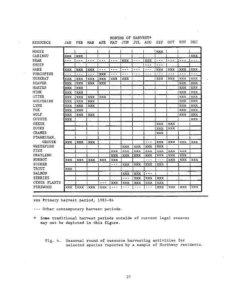
RESOURCE MONTHS OF HARVEST*
JAN FEB MAR APR MAY JUN JUL AUG SEP OCT NOV DEC
MOOSE CARIBOU BEAR SHEEP HARE PORCUPINE MUSKRAT BEAVER MARTEN MINK OTTER WOLVERINE LYNX FOX WOLF COYOTE GEESE DUCKS CRANES PTARMIGAN,
GROUSE WHITEFISH PIKE GRAYLING BURBOT SUCKER TROUT SALMON BERRIES
. . I I I I I I I xxx
xxx lxxx 1 I I I 1 xxx --_ _-- --- __- m-e xxx I___ lxxx --- --- --_ I---
l I I -_- --- xxx xxx lxxx I--- I--- I--- I--- I--- lxxx lxxx xxx lxxx --- -_- --- lxxx I--- I--- I--- __- I--- I__- --- I--- xxx xxx lxxx lxxx lxxx lxxx 1 lxxx lxxx lxxx lxxx _ xxx xxx lxxx lxxx 1 1 lxxx lxxx xxx xxx 1 I I I lxxx lxxx xxx lxxx 1 lxxx lxxx xxx lxxx lxxx xxx lxxx lxxx xxx xxx xxx I I lxxx lxxx xxx xxx xxx lxxx lxxx xxx xxx lxxx lxxx xxx xxx lxxx 1 xxx xxx xxx I xxx
I lxxx xxx 1 I I lxxx lxxx 1
I I I I xxx 1 I I I I I I I I
xxx xxx xxx I -_- xxx lxxx lxxx xxx I I xxx xxx xxx lxxx 1
1 xxx xxx xxx xxx xxx lxxx lxxx 1 xxx xxx xxx xxx xxx lxxx lxxx
xxx xxx xxx xxx lxxx I __- we- 1 xxx xxx lxxx --- xxx lxxx xxx xxx 1 I
xxx I I I I I
r I lxxx lxxx --- l I I I _-_ lxxx lxxx lxxx 1 I I
OTHER PLANTS I I --- lxxx lxxx lxxx lxxx lxxx 1 FIREWOOD xxx lxxx lxxx lxxx I--- I--- I--- I--- lxxx lxxx lxxx lxxx
xxx Primary harvest period, 1983-84
-__ Other contemporary harvest periods.
* Some traditional harvest periods outside of current legal seasons may not be depicted in this figure.
Fig. 4. Seasonal round of resource harvesting activities for selected species reported by a sample of Northway residents.
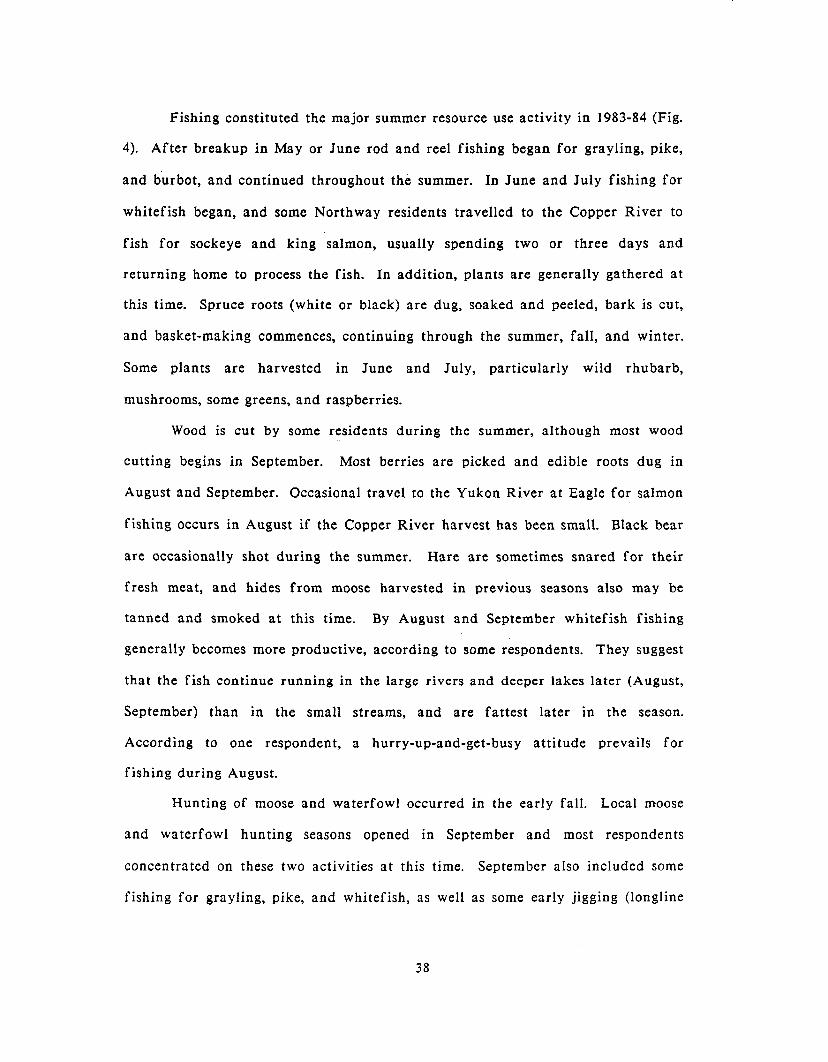
Fishing constituted the major summer resource use activity in 1983-84 (Fig.
4). After breakup in May or June rod and reel fishing began for grayling, pike,
and burbot, and continued throughout the summer. In June and July fishing for
whitefish began, and some Northway residents travelled to the Copper River to
fish for sockeye and king salmon, usually spending two or three days and
returning home to process the fish. In addition, plants are generally gathered at
this time. Spruce roots (white or black) are dug, soaked and peeled, bark is cut,
and basket-making commences, continuing through the summer, fall, and winter.
Some plants are harvested in June and July, particularly wild rhubarb,
mushrooms, some greens, and raspberries.
Wood is cut by some residents during the summer, although most wood
cutting begins in September. Most berries are picked and edible roots dug in
August and September. Occasional travel to the Yukon River at Eagle for salmon
fishing occurs in August if the Copper River harvest has been small. Black bear
are occasionally shot during the summer. Hare are sometimes snared for their
fresh meat, and hides from moose harvested in previous seasons also may be
tanned and smoked at this time. By August and September whitefish fishing
generally becomes more productive, according to some respondents. They suggest
that the fish continue running in the large rivers and deeper lakes later (August,
September) than in the small streams, and are fattest later in the season.
According to one respondent, a hurry-up-and-get-busy attitude prevails for
fishing during August.
Hunting of moose and waterfowl occurred in the early fall. Local moose
and waterfowl hunting seasons opened in September and most respondents
concentrated on these two activities at this time. September also included some
fishing for grayling, pike, and whitefish, as well as some early jigging (longline
38
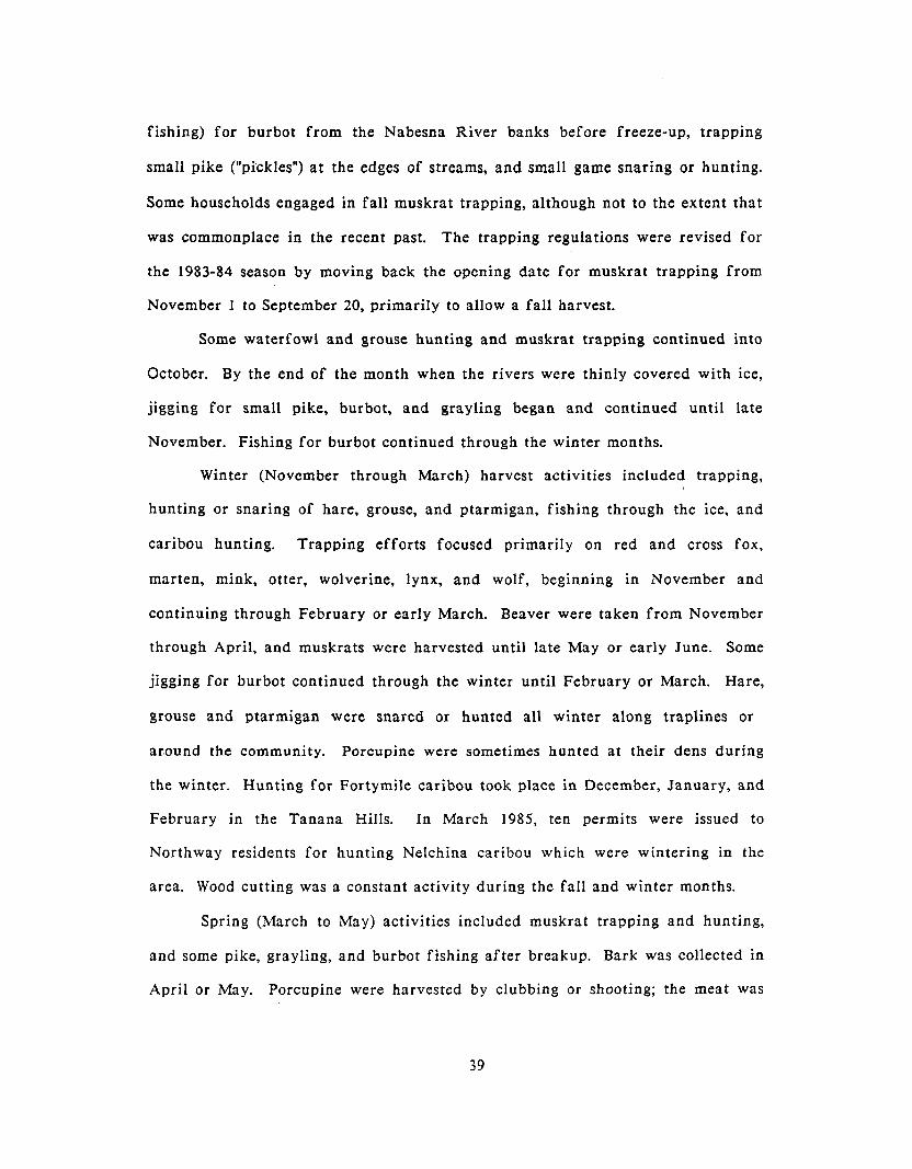
fishing) for burbot from the Nabesna River banks before freeze-up, trapping
small pike (“pickles”) at the edges of streams, and small game snaring or hunting.
Some households engaged in fall muskrat trapping, although not to the extent that
was commonplace in the recent past. The trapping regulations were revised for
the 1983-84 season by moving back the opening date for muskrat trapping from
November 1 to September 20, primarily to allow a fall harvest.
Some waterfowl and grouse hunting and muskrat trapping continued into
October. By the end of the month when the rivers were thinly covered with ice,
jigging for small pike, burbot, and grayling began and continued until late
November. Fishing for burbot continued through the winter months.
Winter (November through March) harvest activities included trapping,
hunting or snaring of hare, grouse, and ptarmigan, fishing through the ice, and
caribou hunting. Trapping efforts focused primarily on red and cross fox,
marten, mink, otter, wolverine, lynx, and wolf, beginning in November and
continuing through February or early March. Beaver were taken from November
through April, and muskrats were harvested until late May or early June. Some
jigging for burbot continued through the winter until February or March. Hare,
grouse and ptarmigan were snared or hunted all winter along traplines or
around the community. Porcupine were sometimes hunted at their dens during
the winter. Hunting for Fortymile caribou took place in December, January, and
February in the Tanana Hills. In March 1985, ten permits were issued to
Northway residents for hunting Nelchina caribou which were wintering in the
area. Wood cutting was a constant activity during the fall and winter months.
Spring (March to May) activities included muskrat trapping and hunting,
and some pike, grayling, and burbot fishing after breakup. Bark was collected in
April or May. Porcupine were harvested by clubbing or shooting; the meat was
39
skinned and roasted and the quills used in jewelry and crafts. Migration routes
of the Fortymile caribou have changed and the herd no longer moves en masse
through the “valley” as it did in the 1920s and 1930s. Current hunting regulations
do not authorize the taking of waterfowl, moose, and caribou during the spring.
Possible continuation of traditional spring waterfowl hunts was not investigated
in this study.
The timing of yearly resource harvest activities in 1983-84 appears similar
to that for the 1920-1960 period: fishing and plant gathering dominated the
summer months, large and small game was pursued heavily in the fall, trapping
constituted a major activity in the winter, and muskrat trapping was the primary
activity documented for the spring season. In contrast with former years, the
scheduling of waterfowl, moose, and caribou hunting has altered significantly.
Waterfowl were traditionally hunted in the spring as well as the fall, and eggs
were collected. Moose were hunted earlier in the fall, in late August, when the
meat could be efficiently dried. Caribou were hunted during the fall migrations,
between September and December, usually in November, and again in the spring
(May). Both moose and caribou were also hunted as necessary the year round.
PARTICIPATION
Participation in different harvesting activities varied between sample
households during the study year (Fig. 5, Table 4). More than 70 percent of the
households harvested or attempted to harvest berries and plants, whitefish, moose,
wood, waterfowl, muskrat, and pike and grayling. Relatively fewer harvested or
attempted to harvest bear (15 percent), porcupine (23 percent), and caribou (29
40
100
30
8Q
70
60
50
49
39
2Q
10
Fig. 5. Percent of Northway sample households undertaking resource harvesting, 1983-84 (n=15).
41
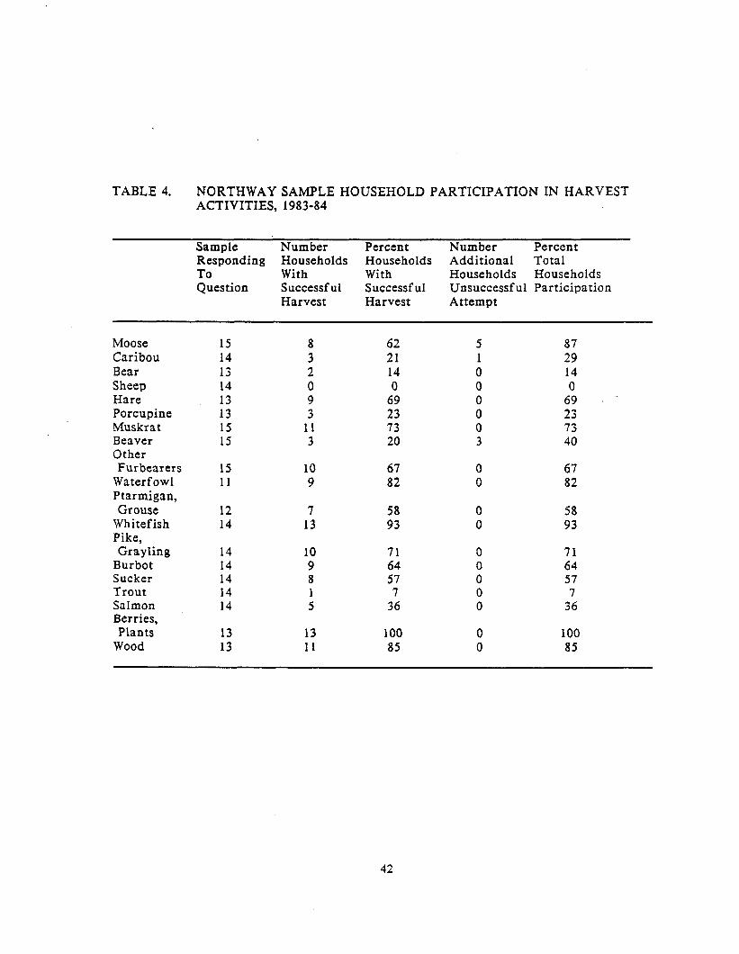
TABLE 4. NORTHWAY SAMPLE HOUSEHOLD PARTICIPATION IN HARVEST ACTIVITIES, 1983-84
Sample Number Percent Number Percent Responding Households Households Additional Total
:Ouestion With With Households Households Successful Successful Unsuccessful Participation Harvest Harvest Attempt
Moose Caribou Bear Sheep Hare Porcupine Muskrat Beaver Other Furbearers
Waterfowl Ptarmigan, Grouse
Whitefish Pike, Grayling
Burbot Sucker Trout Salmon Berries, Plants
Wood
15 14 13 14 13 13 15 15
15 10 67 0 67 11 9 82 0 82
12 7 58 0 58 14 13 93 0 93
14 14 14 14 14
13 13 100 0 100 13 11 85 0 85
; 2 0 9 3
11 3
10 9 8
:
62 21 14 0
69 23 73 20
71 64 57 7
36
87 29 14 0
69 23 73 40
71 64 57 7
36
42

percent). None of the households sought to harvest all 16 resource use categories
(Fig. 5) in 1983-84. The sample pursued an average of about nine resources.
Table 4 indicates that three resource use categories (moose, caribou, and beaver)
included unsuccessful harvest attempts by some sample households. The success
rate of households actually harvesting each of the three resources (moose, 62
percent; caribou, 21 percent; and beaver, 20 percent) was lower than that percent
given in Figure 5 for percent of households undertaking resource harvesting,
which includes unsuccessful harvest attempts. Figure 6 combines the 16
categories into six major resource groups (large game, small game and birds,
waterfowl, fish, furbearers, and plants). It shows that each category was pursued
by more than 70 percent of the sampled households, reflecting relatively high
participation in a range of harvesting activities. It should be remembered that
the sample households were selected to represent relatively active households in
subsistence activities in the community.
Total 1983-84 sample household harvest quantities, and average household
and per capita outputs are listed in Table 5. Land mammals, including large and
small game and two furbearer species, constituted the major portion by weight of
household harvests (48 percent of total output). Moose constituted over two-thirds
(72 percent) of the edible weight of harvested land mammals. Fish comprised 43
percent of household harvests. Over three-quarters of the edible weight of fish
harvested was salmon and whitefish. Average household quantities of harvested
birds and berries totaled nine percent of harvested resources by weight.
The reader is reminded that Northway comprised Athabaskan settlements
oriented to the local riverine environment prior to the construction of the Alaska
Highway and concomitant development of the community. Harvest of resources
for subsistence purposes has been a traditional element of the local economy for
43
90
80
70
50
50
49
30
20
10
0
Fig. 6. Percent of sample households participating in six major categories of harvest activities, 1983-84 (n=15>.
TABLE 5. SUBSISTENCE HARVEST LEVELS FOR A SAMPLE OF NORTHWAY RESIDENTS, 1984-85 .+
RESOURCE
MEAN SAMPLE HOUSEHOLD PER CAPITA
HARVEST CONVERSION* SIZE** HARVEST HARVEST (lbs.) (lbs.)
5.4 14 119 23.8 2.0 14 286 57.2
Salmon Whitefish Whitefish
Burbot Suckers Pike Grayling
309 2005 14 sacks
dried 116
60 104 255
85.0 14 85 17.0 3.0 14 25 5.0
.75 14 3 .6 7.0 14 52 10.4 1.0 14 18 3.6
TOTAL FISH 118. 0 A
Moose 11 650.5 15 477 95.4 Caribou 5 150.0 14 54 10.8 Bear 2 120.0 14 17 3.4 Beaver 37 15.0 15 37 7.4 Muskrat 863 1.0 15 58 11.6 Hare 92 2.0 13 14 2.8 Porcupine 4 10.0 13 3 .6
TOTAL MAMMALS 132 0 A
Geese Ducks Grouse,
Ptarmigan Berries
15 5.0 11 7 1.4 310 2.5 11 70 14.0
138 1.0 12 12 2.4 122 gal 4.0 13 38 7.6
25 0 L TOTAL BIRDS, BERRIES
TOTAL RESOURCES 275 0 A
+ Sample represents only households identified as active harvesters. Mean sample household size - 5.0
* Estimated pounds edible weight. Edible weights for each resource were developed with the assistance of local respondents.
** Excluding no response. Sample may include non-harvesting households.
45
many years. The current (1983-84) harvest levels depicted in Table 5 include
harvests of recent in-migrants represented in the sample as well as long-term
residents. Harvest data present in Table 5 reflect the importance of resource
harvests for newer as well as long-term residents of the sample.
Table 6 suggests that the number of major harvest categories in which
households were involved decreased as the age of the head of household
increased, from about 5.3 resource categories harvested by households with 30-39
year old heads, to 3.0 resource categories harvested by households with 60-69 year
old heads. However, the small sample size means that these trends are only
suggestive of relationships. By comparison, in another Tanana River community,
households with older heads show a higher range of resources harvested than in
the present study (Shinkwin and Case 1984). No other trends are suggested in
household size or employment status in relation to age of household head in Table
6.
Four brief case descriptions of households with varying employment
status, ages, ethnic background and harvest activity follow. They are presented
to illustrate the diversity among the sample respondents.
Household A consisted of an extended family of a husband and wife in
their 4Os, and six dependents ranging in age from one to 19 years. No household
members were employed for wages in 1983-84. Income was primarily from fur
and craft sales. All are Alaska Native except the head, who is non-Native. They
undertook harvest of almost all resource categories (13 of 16) in the study year.
Household B had two adult members in their 30s who were employed full-
time and part-time locally, and two dependent children in their teens. This
household harvested 13 of 16 resource categories. They were non-Native and
unrelated to anyone in the community.
46
TAB
LE 6
. B
RE
AD
TH O
F H
AR
VE
ST
AC
TIV
ITIE
S
AN
D S
OC
IOE
CO
NO
MIC
CH
AR
AC
TER
ISTI
CS
BY
AG
E O
F H
OU
SE
HO
LD O
F S
TUD
Y S
AM
PLE
, 19
83-8
4.
Age
of
H
ouse
hold
H
ead
Ave
rage
N
umbe
r of
A
ctiv
ities
(n
=6)
Ave
rage
H
ouse
hold
S
ize
Ave
rage
A
vera
ge
Num
ber
Num
ber
Num
ber
Num
ber
Ala
ska
Non
-Nat
ive
Em
ploy
ed
Per
sons
N
ativ
e H
ouse
hold
s M
onth
s/Y
ear
Em
ploy
ed
Hou
seho
lds
Per
H
ouse
hold
P
er
Hou
seho
ld
30-3
9 5.
3 3.
0 14
.0
1.3
2 (n
=3)
40-4
9 5.
0 6.
1 5.
9 1.
6 5
(n=7
)
50-5
9 4.
5 4.
5 19
.8
3.0
3 (n
=4)
60-6
9 3.
0 5.
0 6.
0 1.
0 0
(n=l
)
47
Household C was Alaska Native and consisted of two adults in their 50s and
three young adults in their early 20s. Both older adults worked for wages full or
part time for nine months of the year. The household harvested 8 of 16 resources
during the study year.
Household D had five members, two adults in their 50s and 60s and three
sons in their late teens and early twenties. One member was employed part-time
during the study year, and the household pursued 7 of 16 resources. The household
head was non-Native, while the others were Alaska Native.
CONSUMPTION AND DISTRIBUTION
According to key respondent interviews and the survey data, wild resources
are commonly distributed in Northway between households. Most consumption and
distribution of fish and large game, and sharing of labor and equipment, takes
place within groups of related households. For example, a daughter and step-
daughter cut fish for their mother (three households), receiving fish later in the
winter “when they need it.” This probably is a very common practice. Salmon from
the Copper River may be obtained by Northway residents in exchange for help
with processing. It is also simply given, as part of a continuous exchange of
resources between Copper River and Northway households. Within Northway,
fresh salmon is given to non-fishing households by those who obtain it from
Copper River residents. In general, resources are distributed to households who
did not harvest a given resource, or who are close relatives (within two generations
lineally or one step collaterally). In particular, elders are often receivers of wild
resources. Sharing occurs among non-related households of the same generation,
but less often. Distribution between “friends” occurs among households who are
48

not related to others in the community. Large game may be divided between
hunting partners, or fish from one net divided between several households. Labor
is often volunteered in return for fish or meat. Resources are sometimes traded,
such as garden produce for a moose hide. Extensive sharing is accomplished
through visiting, with visitors partaking of meals or receiving packages of meat or
fish.
WHITEFISH HARVEST
Whitefish run in clear streams from the shallow lakes to cooler rivers when
the lake water warms in June or July. There are usually two runs per summer, one
in June or July, and one in August. Between the runs there is a general movement
of the fish up and down streams and in rivers and lakes that does not constitute a
major run but that allows for a continual harvest of some fish. Northway
residents harvest whitefish by two principal methods, each requiring specific
natural conditions and gear. Dip nets are set in weirs constructed in small streams
in the same manner as in earlier years (cf. Martin 1983 for detail), and set gill
nets are used in eddies of the larger rivers or in lakes, especially where stream
currents are flowing. Nets are left in place varying lengths of time, depending on
run strength, the frequency with which individuals wish to check the net, number
of households using the net, extenuating activities, as well as other factors. One
fishwheel was used locally for catching whitefish and incidental species,
including four or five salmon, for a few years until about 1981. It was not
operating during the study year.
Figure 7 depicts fishing locations for whitefish for the 1974-84 mapped
period. Four active dip net sites were located during those years within
49
approximately five miles of Northway village on streams used earlier in the 20th
century. A fifth dip net was used at a fish camp at Tenmile Creek, approximately
15 miles up the Chisana River, that was also active during the pre-1960 period.
Three former dip net sites have not been used for dip netting in over ten years
(Charlieskin, High Cache at Scottie Creek, and a site on Mark Creek), although two
were used with set gill nets. Use of dip net sites may be periodic, as in the case of
one site on Moose Creek destroyed by airstrip construction in the early 194Os,
rebuilt in the late 197Os, and used currently. In 1984 a new weir was under
construction about 50 meters downstream from another current site. All but one of
the dip net sites used currently were accessed on foot or by roadway. One was
accessible only, by river.
Set gill nets were placed in eddies of the Nabesna River within two miles of
Northway village and on the Chisana River just above the mouth of the Nabesna.
They were also placed in the vicinity of dip net sites in shallow lakes or larger
streams. Set gill nets located within five miles of Northway were accessible by
water or roadway and were commonly used during single day trips. Water access
to the nets was gained by canoe or motorized river boat. Sites along the Chisana
River at Tenmile, Stuver, Mark, and Scottie creeks were approached only by river
and some included full camps at which processing took place. Two of these camps
were maintained by one extended family, but were also used by other unrelated
households. Two Scottie Creek camps, located near the High Cache camp of the
former Scottie Creek band, and on the Chisana River at the mouth of Scottie
Creek, were used for gill net fishing by several families, including newer,
unrelated (non-Native) households.
50
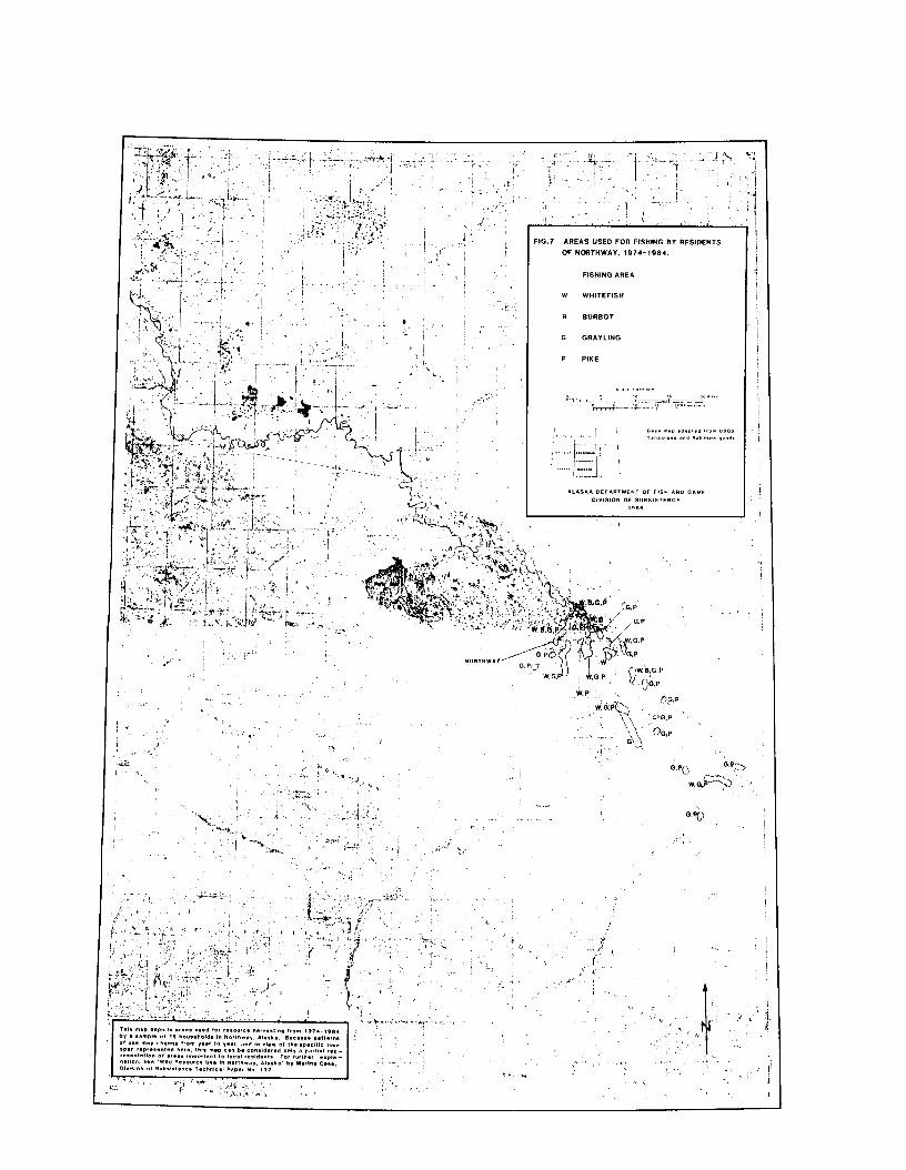
I’ -i , ,._ -‘I.
’ I
I 'i ' I> , ‘:,+ ,... ‘.-'.'r.."-' -
*,,
Eleven of 14 responding sample households reported generally using dip
nets for catching whitefish, although seven of them used dip nets during the
study year. Ten of these households as well as two non-dip netting households
reported also using set gill nets in 1983. The three non-dip netting households
were the non-Native households of the sample, who were unrelated to dip netting
households. Two of them used set gill nets for catching whitefish, while one
reported no fishing activity. Although set gill nets are a relatively recent
development in local fishing patterns, their use by dip netting households was
reported to have increased since about 1980. Reasons for this increase may
reflect changing social patterns in whitefish netting, as discussed below.
Maintenance of dip net weirs during the study year was undertaken by
individual households, two of whom were reported to have inherited the sites
from their father, who had been particularly associated with those sites during
the 1920-1960 period. Most of the dip net sites were used primarily by related
households, usually by invitation or with permission. However, such permission
was reported to be rarely denied, and given without regard to relationship. Many
households used multiple sites during the year to take advantage of relatively
more productive harvests at one site over another. One site, Fish Camp, was used
by 10 of the 11 households who used dip nets, while the other dip net sites were
each used by fewer sample households. Fish Camp was reported to be a highly
productive site open for use by “anyone” in the tribal group, although the site was
maintained primarily by two related households.
Some patterns of dip net use evident during the earlier 20th century
persist into the 198Os, such as use of one net by all users at each site, multiple
site use by households following whitefish runs in the various streams, and
general availability of all sites to all households. Multiple site use during the
52

study year included the use and sharing of set gill nets by most households.
Other patterns may represent variations on those of the earlier part of the
century. .Setting gill nets in the Nabesna River close to Northway Village may
constitute a replacement for travelling to more distant Chisana River sites for
fall whitefish, allowing for harvest of this important seasonal run close to home.
It. may also alleviate a need for cooperation in maintaining fishing sites, due to
the simpler gear arrangement of set nets. One respondent suggested that the
establishment of Native allotments, some of which include dip net sites, seems to
encourage a sense of private property at the sites which deters interest in their
maintenance by some households, and an increase in the use of set nets. Research
to further investigate social patterns related to access to local whitefish harvest
sites is needed.
Tasks included in processing whitefish, such as scaling, cutting,
maintaining a smoking fire, and hanging the fish to smoke and dry, were
accomplished by members of a household, or related members of two to three
households, according to survey results. Some respondents stated that women
normally cut the fish, while men usually check the net and take care of smoking
tasks. However, exceptions to this rule appeared on the survey forms, such that
both men and women reported doing both kinds of tasks.
PIKE, GRAYLING, BURBOT, AND SUCKER HARVEST
Northern pike, Arctic grayling, and burbot (lingcod) were the other major
fish species taken by Northway residents (Fig. 7). Suckers were harvested in
smaller amounts. Suckers were harvested with rod and reel by one household in
the study year and used for dog food.
53
During the study year, burbot were fished by set longline just before
freeze-up (from river banks) or soon after freeze-up. Jigging continued through
November by most respondents, and through April by some, after which burbot
were taken with rod and reel (in May). Fishing through the ice was done mostly
on the Nabesna and Chisana rivers, and also in Moose and Tenmile creeks.
Pike and grayling were harvested with set longline through the ice in
October and November, and by rod and reel from May through September in
clear creeks and small lakes near the airport and village (Moose Creek and several
lakes), as well as in more distant creeks, including Mirror, Scottie, and Gardiner
creeks, and Island Lake. Small pike (“pickles”) run at the edges of streams in the
fall, and were hooked or trapped in funnel-style mesh traps just after freeze-up.
SALMON HARVEST
Salmon fishing sites of Northway residents on the Copper and Yukon
rivers were not systematically mapped for the 1974-84 period. During 1983
salmon were harvested by Northway residents along the Copper River near the
communities of Slana, Chistochina, Gulkana, and Copper Center. A small amount
of salmon fishing was done at Eagle, accessible from the Taylor Highway. The
fish were transported back to Northway processed and whole.
Five of the 14 sampled households fished for salmon during the study year
(Table 4). Eight households that did not fish that year reported it to be an
unusual year for a variety of reasons, and stated that they have fished on the
Copper River during the last ten years. Nine sampled households reported
receiving salmon during the study year from other Northway residents who
obtained it on the Copper River.
54
The following is a brief description of one fishing trip made to the Copper
River during the field work period. Two non-Native Northway households (each
a couple, one with a young son) and a visitor, travelled together to fish at Slana
during July 1984. None of the party was related to Copper River community
residents. The fishing group used two wheels, located roughly two miles apart.
One wheel was jointly owned by a Northway resident and a Tok resident; the
other by a friend of. one of the other owners. The trip took three days, during
which 66 sockeye and one king were caught. The group camped at one of the
wheel sites, canning most of the fish immediately. Fish caught the last morning
were transported whole back to Northway for processing, then divided equally
among the two local households and the visitor.
According to respondents, salmon is often donated by Copper River
residents to potlatch meals in Northway. There are longstanding sib associations
between Upper Tanana and Copper River Ahtna Athabaskans which today define
roles for participants in funeral or memorial potlatches. Visiting, and consequent
sharing of, resources, also occurs between relatives, non-relatives, sib mates, and
non-sib mates of Northway and the Copper River communities. The sample of
Northway households indicated they had begun travelling to the Copper River for
salmon from three to more than 20 years ago. Several of the older respondents
described travelling to the Copper River as children, and recalled hearing stories
of their parents’ and grandparents’ travels to the area. Residents from the
Copper River area also travel to Northway to visit and obtain waterfowl,
whitefish, berries, garden produce, or beadwork. They also may be given muskrat
or offered access to local areas to harvest muskrat. For further detail on use of
Copper River salmon by Upper Tanana residents, see Haynes et al. (1984).
55
MOOSE HUNTING
Mapped data for the 1974-84 period indicate that moose were hunted
primarily from rivers, lakes, and creeks using flat-bottomed riverboats and canoes
for transportation and by hiking cross-country from the waterways (Fig. 8). Use
of all-terrain vehicles (3-wheelers, argos) was limited; only two respondents
indicated accessing hunting areas via off-road vehicles. Air access was also
limited. Two respondents have hunted moose at Carden and Takomahto lakes by
chartering airplanes; another has flown the area to scan for moose locations.
Three highways in the vicinity were regularly used for moose hunting: the Alaska
Highway from the U.S.-Canadian border to Dot Lake, the Glenn Highway from
Tok to and including the Nabesna Road, and the Taylor Highway. Hunters scan
as they drive and hike up to one or two miles from the roads in search of moose.
Moose were also sought while travelling to distant locations for other purposes,
such as to the Copper River area to visit. Several areas north of the Alaska
Highway were also hunted, including the Beaver Creek drainage and lakes west
of Gardiner Creek and north of Paradise Hill, as well as Island Lake and Desper
Creek. Some of these areas were accessible by truck or all-terrain vehicles, while
others were accessed by foot.
Hunting along rivers was extensive. It generally included cross-country
hiking and tracking up to two miles from a water body, spotting from particular
trees, hills, and high banks, and camping. Camps were widely used. Some family
trapping camps doubled as hunting camps and were maintained and occupied in
the fall and winter by members of extended local families. In general, hunters
leave from Northway and either move camp continuously or hunt from a base
camp. Hunters often make day trips from Northway as well.
56
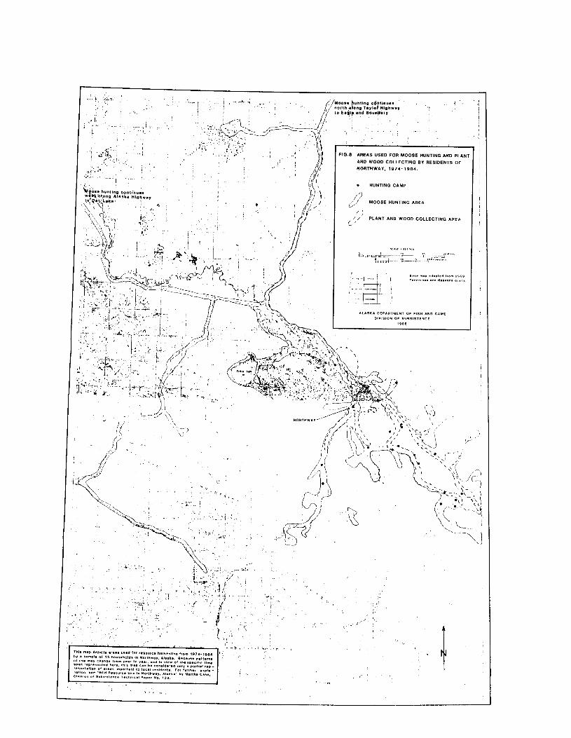
/ ,.
The predominant area hunted via waterways encompassed roughly the
lower 12 miles of the Nabesna River, the lower 35 miles of the Chisana River (to
Gardiner Creek), the Tanana River from the confluence of. the Nabesna and
Chisana rivers to the east end of Midway Lake, and virtually all lakes and
streams south of the Chisana River, east of the Nabesna River, and north of the
Black Hills, including Moose, Stuver, and lower Gardiner creeks.
Two extensions of this core area were hunted by the same families who
inhabited them in the earlier 20th century, and who are in part descended from
former bands which utilized the areas prior to the 20th century. One sample
household with members from the former Scottie Creek band hunted moose at
Scottie and Mirror creeks, but not on the Nabesna Ri,ver. In addition, nine other
households hunted in the Scottie Creek area. Two of them were non-Native with
no historical ties to the area, while the connections of the other seven stemmed
primarily from one family that moved into the Scottie Creek and then the lower
Nabesna areas late in the 19th and early 20th centuries. At that time, this family
used primarily the lower Nabesna and Ladue area but also the Scottie Creek area
to some extent.
On the Nabesna River, seven sample households with descendants of the
former Nabesna band hunted moose along that river to the mouth of the Cheslina
River (a tributary of which is Dry Creek, where a former camp was located).
One of these households did not hunt on the Chisana River at all. Another did
not hunt on Scottie Creek but has gone up the Chisana River past Scottie Creek.
Another household that hunted in this extended part of the Nabesna River moved
to the state and to Northway within the last ten years. The six households that
did not use this part of the river all had male heads who were not originally
from this area. One (now deceased) was from Tetlin, and the others were either
58
from elsewhere in the state or from outside of Alaska. Three of these household
heads, however, were married to women who lived in the Lower Nabesna area in
the mid-20th century. One other was married to a woman from Scottie Creek and
the remaining two were from out-of-state. These data show that moose hunting
areas were not exclusive to former band members, but the farther reaches of the
hunting areas tended to be used by those hunters from families which have had
long-term experience hunting in them. They also suggest that some households
avoided hunting in areas where they have no family history of use. One
respondent also indicated a preference to avoid certain areas with unfamiliar
rivers or terrain. It is evident that contemporary hunting areas fall within
former band territories, the descendants of which comprise a large portion of the
current local hunting population.
In addition, until quite recently some residents continued to hunt on foot
with pack dogs using Northway Village as a starting point. For example, as late
as 1969, one household (a couple) hunted moose by hiking out from Northway
onto former Lower Nabesna band area trails with seven pack dogs, eating small
game harvested along the way, and harvesting, smoking, and drying moose. They
spent roughly a month, returning to the village to enlist the aid of young men to
help carry the meat.
During the study year moose meat was dried, frozen, or canned. In
addition to the meat, major organs (liver, heart, kidney) were used, as well as the
stomach, intestines, lungs, and bones. Some parts, such as the lungs, were used for
dog food. Moose hide was tanned by some residents, who either tanned their own
or those of other residents. One man, for example, occasionally tans hides for his
sister-in-law, who asks him to do it in part because he is “good at it.” Untanned
hides may be obtained by trading such items as garden produce.
59
Examination of survey and interview data on the range of people with
whom a hunter hunted indicates that respondents more often hunted in inter-
household groups than solely with members of their own households. In addition,
groups of relatives as hunting partners were more common than groups of friends.
This statement, however, must be qualified, for it is possible that distantly
related individuals do not consider themselves “relatives” and choose to
characterize their hunting partners as “friends.” Such cognitive definitions of
relationship were not investigated. Nevertheless, data indicate a preponderance
of hunting groups comprised of close relatives, such as sons, brothers, spouses, and
wife’s brothers.
Some respondents also commented that owners of motorized boats take a
variety of people on hunting trips, “like giving someone a lift to the store.” In
general, cooperative use and sharing of equipment, and criteria for composing
work groups other than individual relationship, were not exhaustively
investigated in the study.
CARIBOU HUNTING
Fortymile caribou are present in the Tanana Hills during the late fall and
winter months. They cluster in timbered areas such as the Ladue drainage
several miles north of the Chisana River (Davis et al. 1978). According to local
description, caribou generally have not migrated in large numbers near Scottie
Creek or Northway possibly since the mid-1940s, although isolated groups were
seen occasionally until the early 1960s. More recently (1983-84), caribou have
been observed on Midway Lake and lower Gardiner Creek in the spring. One
respondent reported having seen very few caribou near the Taylor Highway in
60
the last ten years (since approximately 1973). Caribou of the Nelchina and
Mentasta herds appeared to the southwest of Northway during the winter of
1982-83, and again in 1983-84 and 1984-85. Prior to that time, local residents had
sighted no caribou migrating from the south onto the “flats” since the late 1920s.
In addition, a small resident herd has occupied the area around the headwaters of
the Chisana and White rivers since at least the 1920s (Skoog 1968). It is rarely
hunted by Northway residents.
Four modes of access were reported for hunting caribou during the study
year. Driving to points on the Taylor Highway in August and September or in
December and January (if snow conditions permit) was the most common method
of transportation used for hunting Fortymile caribou. Less commonly, cat trails
around Mt. Fairplay on the Taylor Highway as well as at other points (for
instance, around Mile 40) were used for off-highway access, principally on foot.
Snowmachine travel on traplines has allowed harvest of caribou by one trapper;
another noted seeing caribou tracks while on his trapline but has not harvested
them. Two respondents have flown to the Wrangell Mountains to combine caribou
hunting with gold prospecting (Fig. 9).
Only four respondents reported hunting caribou (the Fortymile herd)
during the 1983-84 study year. In general, difficulties for respondents in
pursuing these caribou arose from two principle sources. First, some respondents
disliked hunting close to a highway in the company of many other hunters from
outside the area during the open hunting season. Second, access to the Ladue
River drainage is difficult. In former years families spent weeks or months
camping, harvesting, and drying meat of both moose and caribou in the Ladue
River drainage. Currently, hiking or sledding into this area is considered too
61
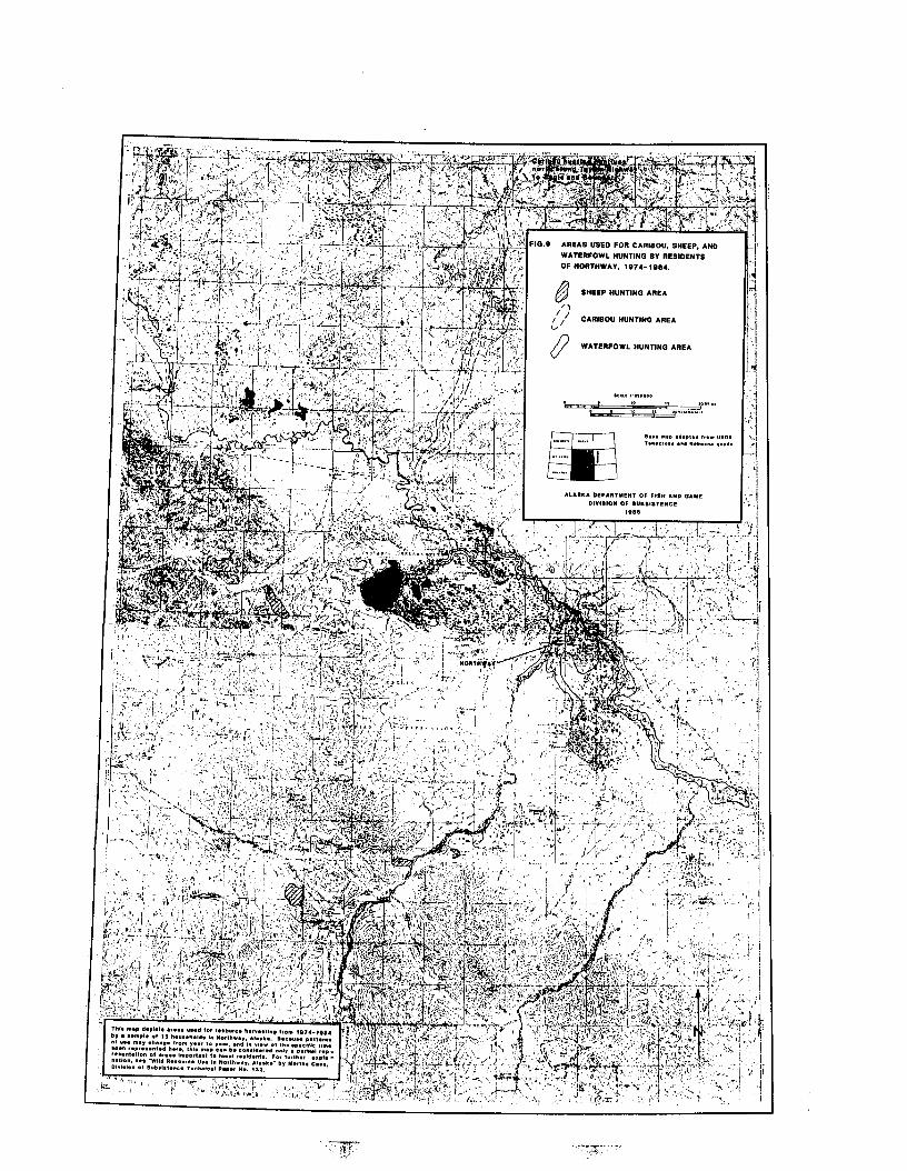
time consuming for families with responsibilities in the community. One
respondent pointed out that the rough, heavily forested terrain in that area
prohibits efficient snowmachine travel.
Hunters in the Northway sample tended not to hunt the Chisana, Mentasta,
or Nelchina herds to the south of Northway in the Nutzotin or Mentasta
mountains. Unless extensive time afield by snowmachine or foot is invested,
efficient access requires expensive air travel, which most households could not
afford. In the past, more time was spent walking to these areas to hunt.
During the 1974-84 period there were notably fewer caribou in the
vicinity of Northway than earlier in the century. Elder local hunters recall
observing huge caribou populations migrating through the Scottie Creek and
lower Nabesna River areas from about 1910 to the 1930s or 194Os, drawing
members of the Upper Chisana band downriver to Scottie Creek in the fall to
hunt. One respondent also noted the presence of caribou on “the flats” around
lower Nabesna River area that appeared from the south ‘in the 192Os, and were
last seen in 1928, after which residents tended to “look north” for caribou. These
caribou from the south may have constituted either Nelchina herd animals or
overflow members of the large Fortymile herd. It was reported that small groups
of caribou in the Lower Nabesna flats area were hunted until roughly the mid-
1940s or mid-1950s, after which they were rarely sighted. These caribou had
moved to the flats area from the Tanana Hills for the winter season. According
to one respondent, the number of caribou in the Ladue River drainage declined
around the 193Os-195Os, causing local hunters to stop using the area.
These local accounts parallel documented historic data on the Fortymile
caribou population and distribution for the area. Davis et al. (1978) summarize
records of the herd’s demography, and report a large population and wide
63
distribution in the 1920s and early 1930s. The population declined until the mid-
194Os, then increased until about 1960, after which it declined dramatically until
the mid-1970s, and since then it has been gradually increasing.
SHEEP HUNTING
Dali sheep were hunted in the eastern extent of the Mentasta Mountains
and the very northern edge of the Wrangell Mountains (Fig. 9). Sheep hunting
during the 1974-84 period was done only occasionally by a few Northway
residents, as access to the mountains south of Northway is difficult and current
regulations involving careful scrutiny of horn curl seemed restrictive. One
household hunted sheep by ascending the Nabesna River by boat approximately
55 miles from Northway and then hiking into the mountains. Two others drove
the Glenn Highway or Nabesna Road, again hiking into the mountains for several
miles.
BEAR HARVEST
Bear hunting areas were not mapped. All respondents maintained that
bear generally are harvested only under fortuitous circumstances or when a hunt
is organized to shoot a nuisance animal in a populated area. One respondent
reported once hunting black bear along a highway. Currently the local
community area reportedly contains a healthy black bear population. The
animals might be shot if they become bothersome around homes. The meat is
offered to residents known to consume it. Limited data indicate that traditional
and current consumption of black bear by local Athabaskans is relatively low.
64

FURBEARER TRAPPING
Local trappers pursued muskrat, marten, red fox, and lynx, and to a lesser
extent, beaver, mink, otter, wolverine, wolf, and coyote during the study year.
Trapping areas of 14 sampled households were mapped for the 1974-84 period by
circumscribing respondents’ trap lines, fallow areas, and in one case, a long-
fallow area that had been surveyed for trapping during the coming year. The
area covered was extensive and included stretches of roadside (approximately 50-
100 feet from the roadways) as well as lowland lake and stream areas and
forested hills. The most intensively used areas were the lower Nabesna and
Chisana rivers from the Black Hills to their confluence, and the hills north of the
Alaska Highway towards the south fork of the Ladue River and Gardiner Creek
(Fig. 10). Camps containing tents or cabins were distributed over the entire area.
Respondents have trapped in the area for an average of 25 years (n=14, range 5-
41 years). Snowmachines were the most common form of transportation, although
dog teams were also used by two households.
Use rights for trapping areas, which are considered private (and may be
shared), are acquired by inheritance, usually through the trapper’s or spouse’s
father or grandfather. They also can be acquired by observing lack of trapping
activity, and subsequent inquiry. Rules concerning trapping use rights were not
investigated in this study. For a more detailed discussion of customary use rights
in trapping on the middle Yukon River, see Robert (1984). Location of trapping
areas for most respondents clearly reflects former band associations. In addition,
two non-Native men who married locally trap or have trapped in areas inherited
from their wives’ fathers. Other previously non-local trappers began in areas that
65
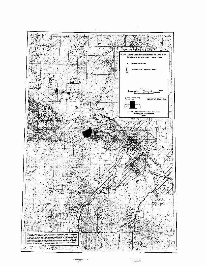
G.10 AREAS “8EO FOR FURBEARER TRAPPING B”
RESIDENTS OF WORTHWA”. 1974-19.34.
. TRlPPlWO CIMP
0 FURBEARER TRAPPlNQ AREI
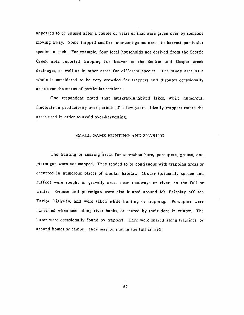
appeared to be unused after a couple of years or that were given over by someone
moving away. Some trapped smaller, non-contiguous areas to harvest particular
species in each. For example, four local households not derived from the Scottie
Creek area reported trapping for beaver in the Scottie and Desper creek
drainages, as well as in other areas for different species. The study area as a
whole is considered to be very crowded for trappers and disputes occasionally
arise over the status of particular sections.
One respondent noted that muskrat-inhabited lakes, while numerous,
fluctuate in productivity over periods of a few years. Ideally trappers rotate the
areas used in order to avoid over-harvesting.
SMALL GAME HUNTING AND SNARING
The hunting or snaring areas for snowshoe hare, porcupine, grouse, and
ptarmigan were not mapped. They tended to be contiguous with trapping areas or
occurred in numerous places of similar habitat. Grouse (primarily spruce and
ruffed) were sought in gravelly areas near roadways or rivers in the fall or
winter. Grouse and ptarmigan were also hunted around Mt. Fairplay off the
Taylor Highway, and were taken while hunting or trapping. Porcupine were
harvested when seen along river banks, or snared by their dens in winter. The
latter were occasionally found by trappers. Hare were snared along traplines, or
around homes or camps. They may be shot in the fall as well.
67
WATERFOWL HUNTING
The study area provides prime habitat for several species of migratory
ducks, many of which were harvested by local residents during the study year
(bufflehead, mallard, spoonbill, pintail, bluebill, green- and blue-winged teal,
black duck, canvasback, and widgeon). The area also supports populations of
four species of geese (lesser Canada, cackling Canada, greater white-fronted, and
snow geese). Canada geese were the species most commonly harvested. Mapped
areas indicate that most waterfowl hunting was concentrated within a five mile
radius of Northway Village and the airport, including many lakes, Moose Creek,
and the lower Nabesna and Chisana rivers (Fig. 9). Waterfowl were also hunted
at Tenmile and Deadman lakes and the Scottie Creek,drainage, as well as from
the Chisana River itself. They were also taken from the Tanana River down to
and including the Tetlin River, and on Tetlin Lake.
PLANT AND WOOD COLLECTING
Berries (including blueberry, highbush and lowbush cranberry, crowberry,
red and black currents, raspberry, rosehips, salmonberry, dewberry, and wild
strawberry), and other edible plants (several varieties of mushrooms, wild
rhubarb, an edible root, labrador tea, greens such as fireweed, pigweed, and
lamb’s quarters) were collected around the lakes, streams, roadways, and hills
within approximately ten miles of Northway. They were also picked at spots
along the Chisana River, Scottie Creek, and hills and flats north of the Alaska
Highway, including Paradise Hill, and the Taylor Highway, particularly the Mt.
Fairplay area. Wood (including white and black spruce, birch, aspen, alder, and
68
willow) was cut along the major rivers as well as along the Alaska Highway and
Paradise Hill (Fig. 8).
Birch bark and spruce roots were used for making baskets, many of which
were sold through the local gift shop owned by Northway Natives, Inc. Birch,
willow, and spruce were used for making furniture, canoes and paddles,
snowshoes, and dip nets. Wood used for smoking whitefish or salmon may be
alder, aspen, birch, spruce, or willow.
SUMMARY
Northway residents contacted for this study utilized many of the same
wild resources and harvested them during the same times of the year as was the
case during the 1920-1960 period. Resources commanding the highest
participation levels during the study year included berries, wood, whitefish,
moose, waterfowl, muskrat, and hare. Other resources of particular importance
were caribou, salmon, and furbearers. Dal1 sheep, marmot, and ground squirrel
were used less frequently. Available data suggest tha.t the number of harvest
activities in which households were involved decreased as head of household age
increased, although caution must be exercised given the small sample size.
Distribution of resources between households was widespread. Initial data
analysis suggests that much distribution occurred within family (close relative)
groups. In addition, foods were shared in ritual contexts such as funeral and
memorial potlatches.
The resource use area maps and foregoing descriptions indicate that
hunting for moose, waterfowl, small game, and birds was oriented to the corridors
of rivers and/or roadways, including adjacent ponds and streams. Trapping,
69

including snaring of hare, covered extensive land areas between the major rivers,
as well as strips of land along the Alaska Highway. Fishing was concentrated on
streams, lakes, and rivers within approximately ten miles of Northway Village.
Fishing sites also occurred along the Chisana drainage downriver from Scottie
Creek. Wood was cut where access was relatively easy, primarily in off-roadway
areas. Berries were collected around homes and within walking distance of the
community and roadways, as well as at particular spots along rivers.
While little information was collected on the social dynamics of use of
hunting or trapping camps, the use of camps was prevalent among local residents.
Some camps have been maintained for years. Camps were often used for single as
well as several resource activities (fishing, hunting, and trapping). Further
information on the settlement pattern and use of local camps would increase an
understanding of land use dynamics of the Northway area.
Of particular interest in drawing historical comparisons are harvest
patterns of whitefish and moose. While there appeared to be no local social
restrictions on locality of moose harvest, there nevertheless appeared to be a
tendency for hunters who are descendants or former members of local bands to
hunt in their former band areas. Former traditional band areas remain familiar
to many Northway residents today, and settlement at Northway or efficient
transportation methods has not precluded use of these lands. The extent of land
area traversed on foot and seasonally occupied has decreased since the mid-20th
century period, yet efficient transportation methods today allow for continued
use of a major part of the bands’ former areas.
Use of whitefish dip net sites during the study period also showed
continuous use of historic sites. Fishing sites were numerous between 1920 and
1960, as they are today. They previously were associated to some extent with
70
family groups, while being utilized by all members of the local band as well as
members of visiting bands. Sharing of sites was also common during that study
year. Caution must be exercised in drawing conclusions regarding current
traditional ownership patterns and access rights to fishing sites.
Some Northway respondents reported an increasing use of the local area
for resource harvesting by non-local hunters in recent years. They reported
seeing greater numbers of vehicles parked along the Northway Road for hunting
moose and waterfowl. Trappers reported encroachment onto their established
trapping areas by non-local trappers. Also reported, although not in the context
of competition per se, was a low moose population in the general area, in contrast
to an apparently flourishing habitat.
Some respondents perceived the inception of the Tetlin National Wildlife
Refuge (Fig. 2) under the Alaska National Interest .Lands Conservation Act
(ANILCA) in 1980 to have increased the number of non-local resource users in
the area. One trapper, for example, reported discontinuing his trapping around
the Takomahto Lake region because of the establishment in 1980 of a guiding
camp there. The increasing Fairbanks population with direct highway access to
the Northway area may also account for possible increased hunting in the area.
Further research in Northway and other Upper Tanana communities could be
directed toward identifying current harvest levels and further examining other
aspects of resource harvest and utilization. Data analysis then, could in turn be
directed toward a closer study of community access to resources and competition
for resources between local and non-local users.
71
CHAPTER 8
CONCLUSIONS
Northway is a road-connected community in east-central Alaska with a
1984 population of approximately 334. About 75 percent of the residents are
Athabaskan descendants or former members of four bands who inhabited areas to
the north, south, and east of the present community. Most of the remainder of
the population arrived after the early 1940s.
Until approximately 1940, the four bands occupied adjacent territories
surrounding the two major rivers, the Nabesna and the Chisana, which meet to
form the Tanana. Each band maintained separate summer fish camps and
followed similar seasonal resource harvesting patterns. Major impetus for
settlement at Northway initially derived from the presence of trading posts and
schools.
Today, local resource harvesting activities are a continuation of historic
patterns, with slight differences in the seasonal scheduling of moose and caribou
hunting, and decreases in harvesting sheep, marmots, and ground squirrels found
in the more remote mountainous habitats of former band areas. Moose and
whitefish during the study period constituted dietary staples of the community.
In the past, caribou was also a dietary staple, until herds decreased after the
1940s (McKennan 1959). Reestablishment of local caribou populations likely
would coincide with greater use once again.
Resource harvest areas today lie within former band areas, although they
are not as extensive as the former areas. The uppermost Chisana and Nabesna
rivers and the Ladue River drainage are not used as intensively today as they
72

were when the bands followed a more dispersed settlement pattern. Band
members still maintain ties to these areas, and their use in the future is possible.
Most other areas formerly used by the bands are used today.
The use of fishing sites and hunting and trapping areas clearly reflect
former use patterns, Whitefish, for example, are fished from a community dip
net site as well as from family sites as they were earlier in the century. Trapping
areas are in part inherited from fathers, indicating that many residents today are
trapping in areas associated with former band use rights. Hunting areas now
encompass parts of three of the former band areas, and use of these areas is open
to all hunters. However, analysis of several respondents’ hunting areas indicates
that former band members tend to use their former band-associated areas more
’ than other areas;
Two issues that concern resource use were discussed by respondents. The
first involves a general concern that an increasing use of the local area for
resource harvesting by non-local hunters and trappers has negatively impacted
local hunting and trapping activities and will continue to harm local
opportunities for resource harvesting in the future. Some respondents associate
this increase with the inception of the Tetlin National Wildlife Refuge, which
encompasses much of the current Northway resource us& area. A major source of
potential non-local resource users in the Northway area may derive from the
Fairbanks area, accessible by highway from Northway. One fear is that
transportation methods, specifically off-road vehicles, might be restricted on the
refuge in the future due to over-use of such vehicles by non-local resource users.
Protection of wildlife and of subsistence rights for local users was viewed as a
benefit of the refuge designation.
73
The other issue concerns the difficulty of harvesting large game,
specifically moose, within the fall open season. Several respondents maintained
that regulatory restrictions on the seasonality of moose hunting were difficult to
comply with if the harvester intended to “put meat on the table.” Resource
harvesting in general was pointed out by one respondent as “very hard work” that
takes much time and effort to be successful.
This report has presented general baseline data on resource harvesting
activities of the Northway community, derived from an active sample population
of local resource users. Future research might focus on social organization of
resource use, harvest levels, mobility and settlement patterns of resource harvest
efforts, distribution and exchange of resources, and economic factors, all or some
of which might elucidate the issues of harvest difficulty and competition from
non-local users.
74
REFERENCES CITED
Alaska Department of Community and Regional Affairs 1984 Population Census Report: Northway Community. Division of Local
Government Assistance, Juneau.
Alaska Department of Fish and Game 1978 Alaska’s Wildlife and Habitat. Vol. 11:40.
Alaska Department of Revenue 1985 Federal Income Taxpayer Profile 1978, 1981, 1982 by Alaska
Community and Income Level and Filing Status.
Allen, Henry T. 1887 Report of an Expedition to the Copper, Tanana, and Koyukuk Rivers,
in the Territory of Alaska, in the Year 1885. Washington D.C.: U. S. Government Printing Off ice.
Andrews, Elizabeth 1975 Salcha: An Athapaskan Band of the Tanana River and its Culture.
MA. thesis. Anthropology Department, University of Alaska, Fairbanks.
Clark, A.M. 1981 Koyukon. h Handbook of North American Indians: Subarctic. June
Helm, ed. Vol.6: 582-601 Washington: Smithsonian Institution.
Cole, Terrance 1979 General Comments on a Bureau of Land Management Report on
“Navigable and Non-navigable Water Bodies in the Northway Area.” Division of Forest, Land, and Water Management, Department of Natural Resources. Memorandum.
Damas, David 1969 Contributions to Anthropology: Band Societies. Proceedings’of the
Conference on Band Organization. D. Damas, ed. National Museums of Canada, Bulletin 228. Ottawa.
Darbyshire and Associates 1980 Socioeconomic Community Profiles: A Background for Planning
(Northway). Prepared for Northwest Alaska Pipeline Company, Fairbanks, Alaska.
Davis, James L., Richard Shideler, and Robert E. LeResche 1978 Fortymile Caribou Herd Studies. Division of Game, Alaska Department
of Fish and Game, Juneau.
Guedon, Marie-Francoise 1974 People of Tetlin, Why Are You Singing ? Ethnology Division, National
Museums of Canada, Mercury Series, Paper No. 9.
75
Haynes, Terry L. 1984 Rural Aging and the Use of Social Supports in the Upper Tanana
Region, Alaska. Ph.D. dissertation. Anthropology Department, University of California, San Francisco and Berkeley.
Haynes, Terry L., Martha Case, James A. Fall, Libby Halpin, and Michelle Robert 1984 The Use of Copper River Salmon and other Wild Resources by Upper
Tanana Communities 1983-84. Division of Subsistence, Alaska Department of Fish and Game, Technical Paper No. 115.
Helm, June, and T. Alliband, T. Birk, V. Lawson, S. Reisner, C. Sturtevant, S. Witokowski 1975 The Contact History of the Subarctic Athabaskans: An Overview. In
Proceedings of the Northern Athabaskan Conference, 1971. A.M. Clark, ed. Vol.1: 302-336. Ottawa: Canadian Ethnology Service Paper No. 27.
Johnson, George 1966 Chisana. Alaska Sportsman 5:3 l-33.
Leacock, Eleanor 1982 Relations of Production in Band Society. & Politics and History in
Band Societies. E. Leacock and R. Lee, eds. ‘Cambridge: Cambridge University Press.
Martin, Gayle 1983 Use of Natural Resources by the Residents of Dot Lake, Alaska.
Division of Subsistence, Alaska Department of Fish and Game, Technical Paper No. 19.
McKennan, Robert A. 1981 Tanana. b Handbook of North American Indians: Subarctic. June
Helm, ed. Vol. 6: 562-576, Washington: Smithsonian Institution.
1969a Athapaskan Groups of Central Alaska at the Time of White Contact. Ethnohistory 16: 335-344.
1969b Athapaskan Groupings and Social Organization in Central Alaska. & Contributions to Band Societies. D. Damas, ed. National Museums of Canada, Bulletin 228: 93- 114.
1959 The Upper Tanana Indians. Yale University Publications in Anthropology No. 55.
Moffit, F.H., and Adolph Knopf 1910 Mineral Resources of the Nabesna-White River District, Alaska. United
States Geological Survey, Bulletin 417. Washington D.C.: Government Printing Office.
76
Murray, D.F. 1961 Some Factors Affecting the Production and Harvest of Beaver in the
Upper Tanana River Valley, Alaska. MS. thesis, Biology Department, University of Alaska, Fairbanks.
Nelson, Richard K. 1974 Hunters of the Northern Forest. Chicago: University of Chicago Press.
Pitts, Roger S. 1972 The Changing Settlement Patterns and Housing Types of the Upper
Tanana Indians. M.A. thesis, Anthropology Department. University of Alaska, Fairbanks.
Reckord, Holly 1983a That’s the Way We Live: Subsistence in the Wrangell-St. Elias National
Park and Preserve. Anthropology and Historic Preservation, Cooperative Park Studies Unit, Fairbanks, Alaska. Occasional Paper No. 34.
1983b Where Raven Stood: Cultural Resources of the Ahtna Region. Anthropology and Historic Preservation, Cooperative Park Studies Unit, Fairbanks, Alaska. Occasional Paper No. 35.
Robert, Michelle 1984 Trapping Patterns in the Vicinity of the Kaiyuh Flats, West Central
Alaska. Division of Subsistence, Alaska Department of Fish and Game, Technical Paper No. 84.
Shinkwin, Anne, Jean Aigner, and Elizabeth Andrews 1980 Land Use Patterns in the Upper Tanana Valley, Alaska.
Anthropological Papers of the University of Alaska, Vol. 19(2):43-53.
Shinkwin, Anne, and Martha Case 1984 Modern Foragers: Wild Resource Use in Nenana Village, Alaska.
Division of Subsistence, Alaska Department of Fish and Game, Technical Paper No.9 1.
Skoog, Ronald 0. 1968 Ecology of the Caribou in Alaska. Ph.D. dissertation. Zoology
Department, University of California, Berkeley. Ann Arbor: University Microfilms International.
United States Department of the Interior 1985 Tetlin National Wildlife Refuge Draft: Comprehensive Conservation
Plan/Environmental Impact Statement/Wilderness Review. United States Fish and Wildlife Service, Anchorage.
VanStone, James W. 1974 Athapaskan Adaptations: Hunters and Fishermen of the Subarctic
Forests. Illinois: AHM Publishing Corporation.
77

Vierick, Leslie, and Elbert L. Little, Jr. 1972 Alaska Trees and Shrubs. United States Department of Agriculture,
Forest Service, Agriculture Handbook No. 410.
Vitt, Ramon B. 1971 Hunting Practices of the Upper Tanana Athapaskans. M.A. thesis,
Anthropology Department, University of Alaska.
78