Embed Size (px)
Citation preview
WILDFIRE Wildfire and Urban Wildfire are an ongoing concern for Placer County. Generally, the fire season extends from early spring to late fall. Fire conditions arise from a combination of hot weather, an accumulation of vegetation, and low moisture content in air and fuel. These conditions, when combined with high winds and years of drought, increase the potential for wildfire to occur. While the wildfire risk is predominantly associated with Wildland-Urban Interface (WUI) areas, significant wildfires can also occur in heavily populated areas, as was demonstrated by the 2002 Sierra Fire in the Loomis area. WUI is a general term that applies to development interspersed or adjacent to landscapes that support wildland fire. WUI areas have been a major focus of California Department of Forestry and Fire Protection’s (CDF) fire management strategy since at least 1972. A fire along this wildland/urban interface can result in major losses of property and structures. Potential losses from wildfire include: human life, structures and other improvements; natural and cultural resources; the quality and quantity of the water supply; other assets such as timber, range and crop land, and recreational opportunities; and economic losses. Smoke and air pollution from wildfires can be a severe health hazard. In addition, catastrophic wildfire can lead to secondary impacts or losses such as future flooding and landslides during the rainy season. Generally, there are three major factors that sustain wildfires and predict a given area’s potential to burn. These factors are fuel, topography, and weather.
• Fuel – Fuel is the material that feeds a fire and is a key factor in wildfire behavior. Fuel is generally classified by type and by volume. Fuel sources are diverse and include everything from dead tree needles and leaves, twigs, and branches to dead standing trees, live trees, brush, and cured grasses. Also to be considered as a fuel source, are man-made structures, such as homes, and other associated combustibles. The type of prevalent fuel directly influences the behavior of wildfire. Light fuels such as grasses burn quickly and serve as a catalyst for fire spread. In addition, “ladder fuels” can spread a ground fire up through brush and into trees, leading to a devastating crown fire, one that burns in the upper canopy and cannot be controlled. The volume of available fuel is described in terms of Fuel Loading. Certain areas in and surrounding Placer County are extremely vulnerable to fires as a result of dense vegetation combined with a growing number of structures being built near and within rural lands. The presence of fine fuels, 1000 hr fuels and needle cast combined with the cumulative effects of previous drought years, heavy vegetation mortality, tree mortality and blowdown across Placer County has added to the fuel loading in the area. Fuel is the only factor that is under human control.
• Topography - An area’s terrain and land slopes affect its susceptibility to wildfire
spread. Both fire intensity and rate of spread increase as slope increases due to the tendency of heat from a fire to rise via convection. The arrangement of vegetation throughout a hillside can also contribute to increased fire activity on slopes.
Weather - Weather components such as temperature, relative humidity, wind, and lightning also affect the potential for wildfire. High temperatures and low relative humidity dry out the fuels
Placer County 65 Multi-Hazard Mitigation Plan January 2005
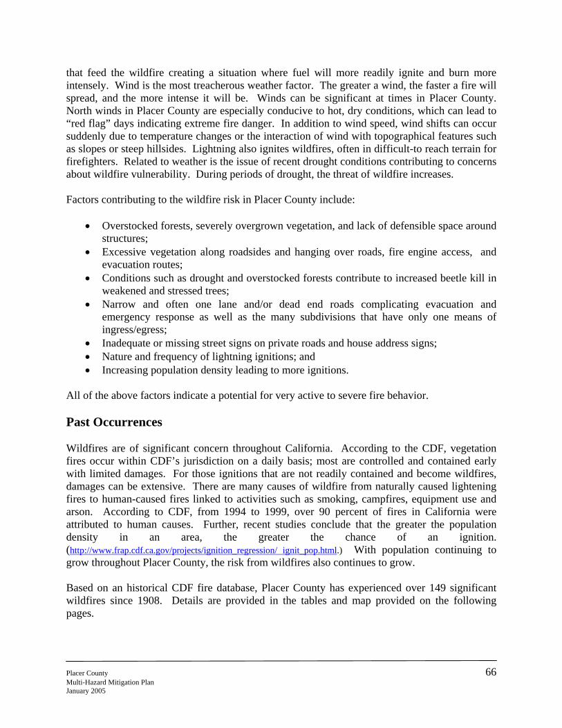
that feed the wildfire creating a situation where fuel will more readily ignite and burn more intensely. Wind is the most treacherous weather factor. The greater a wind, the faster a fire will spread, and the more intense it will be. Winds can be significant at times in Placer County. North winds in Placer County are especially conducive to hot, dry conditions, which can lead to “red flag” days indicating extreme fire danger. In addition to wind speed, wind shifts can occur suddenly due to temperature changes or the interaction of wind with topographical features such as slopes or steep hillsides. Lightning also ignites wildfires, often in difficult-to reach terrain for firefighters. Related to weather is the issue of recent drought conditions contributing to concerns about wildfire vulnerability. During periods of drought, the threat of wildfire increases. Factors contributing to the wildfire risk in Placer County include:
• Overstocked forests, severely overgrown vegetation, and lack of defensible space around structures;
• Excessive vegetation along roadsides and hanging over roads, fire engine access, and evacuation routes;
• Conditions such as drought and overstocked forests contribute to increased beetle kill in weakened and stressed trees;
• Narrow and often one lane and/or dead end roads complicating evacuation and emergency response as well as the many subdivisions that have only one means of ingress/egress;
• Inadequate or missing street signs on private roads and house address signs; • Nature and frequency of lightning ignitions; and • Increasing population density leading to more ignitions.
All of the above factors indicate a potential for very active to severe fire behavior. Past Occurrences Wildfires are of significant concern throughout California. According to the CDF, vegetation fires occur within CDF’s jurisdiction on a daily basis; most are controlled and contained early with limited damages. For those ignitions that are not readily contained and become wildfires, damages can be extensive. There are many causes of wildfire from naturally caused lightening fires to human-caused fires linked to activities such as smoking, campfires, equipment use and arson. According to CDF, from 1994 to 1999, over 90 percent of fires in California were attributed to human causes. Further, recent studies conclude that the greater the population density in an area, the greater the chance of an ignition. (http://www.frap.cdf.ca.gov/projects/ignition_regression/ ignit_pop.html.) With population continuing to grow throughout Placer County, the risk from wildfires also continues to grow. Based on an historical CDF fire database, Placer County has experienced over 149 significant wildfires since 1908. Details are provided in the tables and map provided on the following pages.
Placer County 66 Multi-Hazard Mitigation Plan January 2005
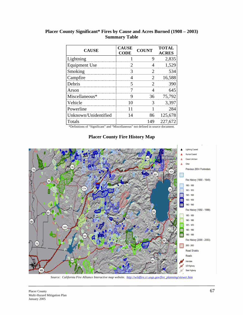
Placer County Significant* Fires by Cause and Acres Burned (1908 – 2003) Summary Table
CAUSE CAUSE CODE COUNT TOTAL
ACRES Lightning 1 9 2,835 Equipment Use 2 4 1,529 Smoking 3 2 534 Campfire 4 2 16,588 Debris 5 2 390 Arson 7 4 645 Miscellaneous* 9 36 75,792 Vehicle 10 3 3,397 Powerline 11 1 284 Unknown/Unidentified 14 86 125,678 Totals 149 227,672 *Definitions of “Significant” and “Miscellaneous” not defined in source document.
Placer County Fire History Map
Source: California Fire Alliance Interactive map website. http://wildfire.cr.usgs.gov/fire_planning/viewer.htm
Placer County 67 Multi-Hazard Mitigation Plan January 2005
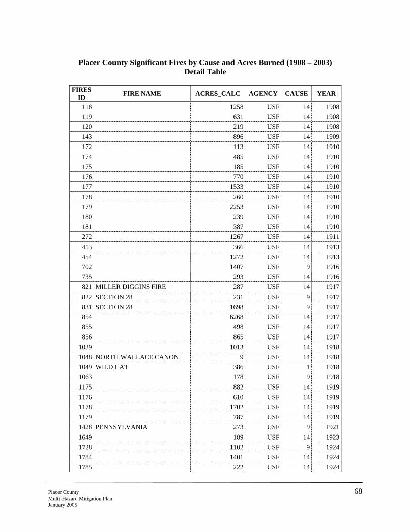
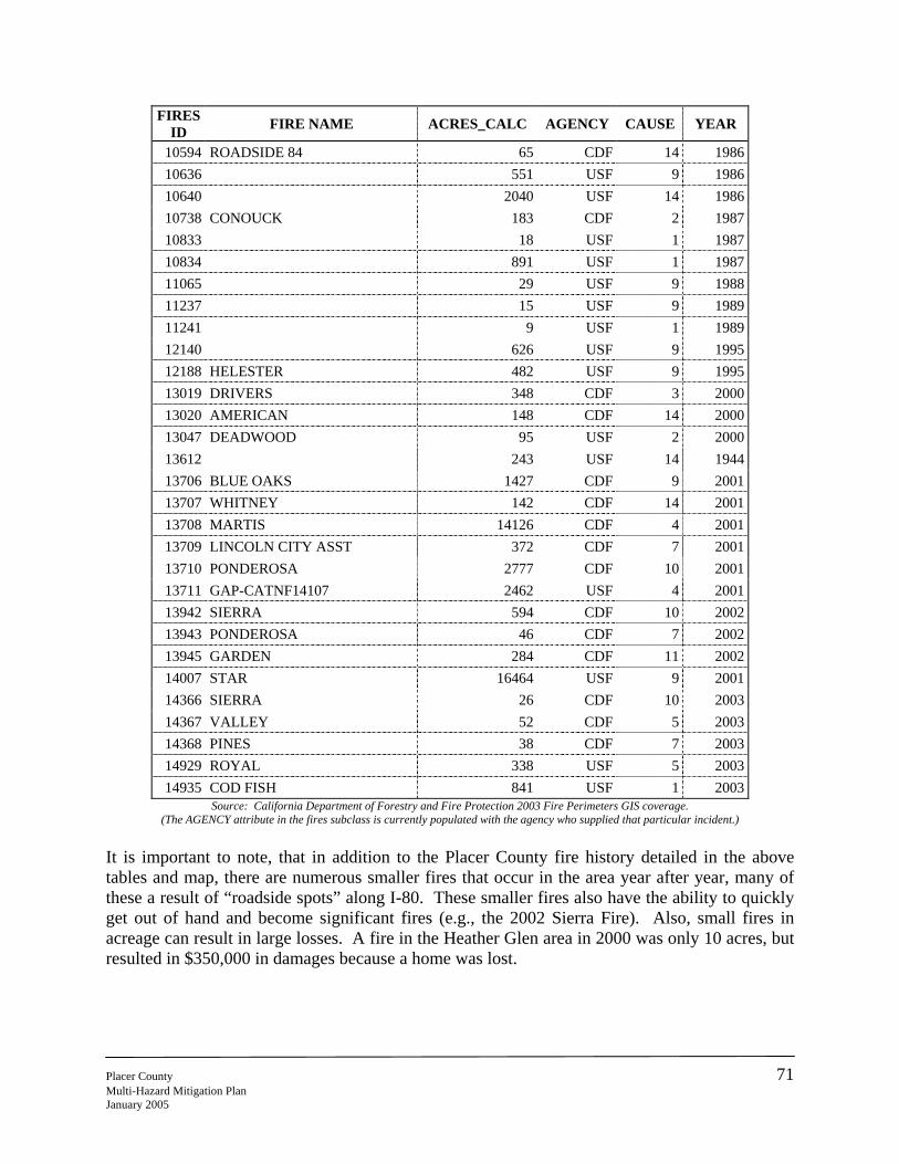
Placer County Significant Fires by Cause and Acres Burned (1908 – 2003)
Detail Table
FIRES ID FIRE NAME ACRES_CALC AGENCY CAUSE YEAR
118 1258 USF 14 1908119 631 USF 14 1908120 219 USF 14 1908143 896 USF 14 1909172 113 USF 14 1910174 485 USF 14 1910175 185 USF 14 1910176 770 USF 14 1910177 1533 USF 14 1910178 260 USF 14 1910179 2253 USF 14 1910180 239 USF 14 1910181 387 USF 14 1910272 1267 USF 14 1911453 366 USF 14 1913454 1272 USF 14 1913702 1407 USF 9 1916735 293 USF 14 1916821 MILLER DIGGINS FIRE 287 USF 14 1917822 SECTION 28 231 USF 9 1917831 SECTION 28 1698 USF 9 1917854 6268 USF 14 1917855 498 USF 14 1917856 865 USF 14 1917
1039 1013 USF 14 19181048 NORTH WALLACE CANON 9 USF 14 19181049 WILD CAT 386 USF 1 19181063 178 USF 9 19181175 882 USF 14 19191176 610 USF 14 19191178 1702 USF 14 19191179 787 USF 14 19191428 PENNSYLVANIA 273 USF 9 19211649 189 USF 14 19231728 1102 USF 9 19241784 1401 USF 14 19241785 222 USF 14 1924
Placer County 68 Multi-Hazard Mitigation Plan January 2005
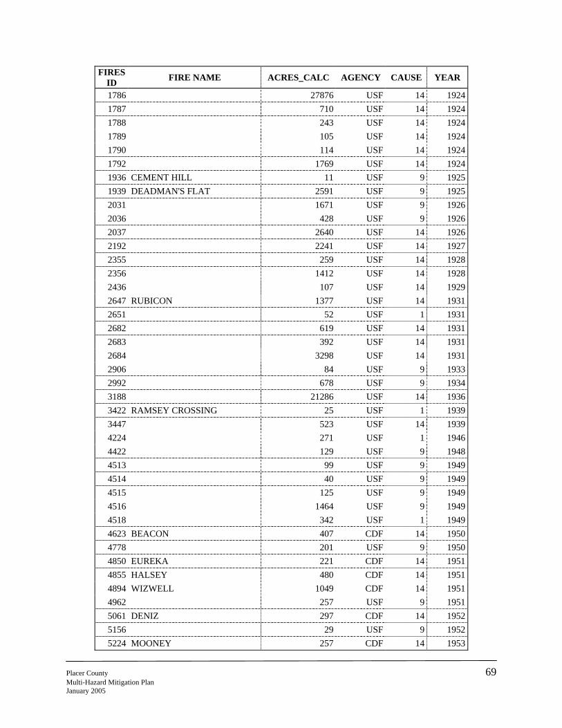
FIRES ID FIRE NAME ACRES_CALC AGENCY CAUSE YEAR
1786 27876 USF 14 19241787 710 USF 14 19241788 243 USF 14 19241789 105 USF 14 19241790 114 USF 14 19241792 1769 USF 14 19241936 CEMENT HILL 11 USF 9 19251939 DEADMAN'S FLAT 2591 USF 9 19252031 1671 USF 9 19262036 428 USF 9 19262037 2640 USF 14 19262192 2241 USF 14 19272355 259 USF 14 19282356 1412 USF 14 19282436 107 USF 14 19292647 RUBICON 1377 USF 14 19312651 52 USF 1 19312682 619 USF 14 19312683 392 USF 14 19312684 3298 USF 14 19312906 84 USF 9 19332992 678 USF 9 19343188 21286 USF 14 19363422 RAMSEY CROSSING 25 USF 1 19393447 523 USF 14 19394224 271 USF 1 19464422 129 USF 9 19484513 99 USF 9 19494514 40 USF 9 19494515 125 USF 9 19494516 1464 USF 9 19494518 342 USF 1 19494623 BEACON 407 CDF 14 19504778 201 USF 9 19504850 EUREKA 221 CDF 14 19514855 HALSEY 480 CDF 14 19514894 WIZWELL 1049 CDF 14 19514962 257 USF 9 19515061 DENIZ 297 CDF 14 19525156 29 USF 9 19525224 MOONEY 257 CDF 14 1953
Placer County 69 Multi-Hazard Mitigation Plan January 2005
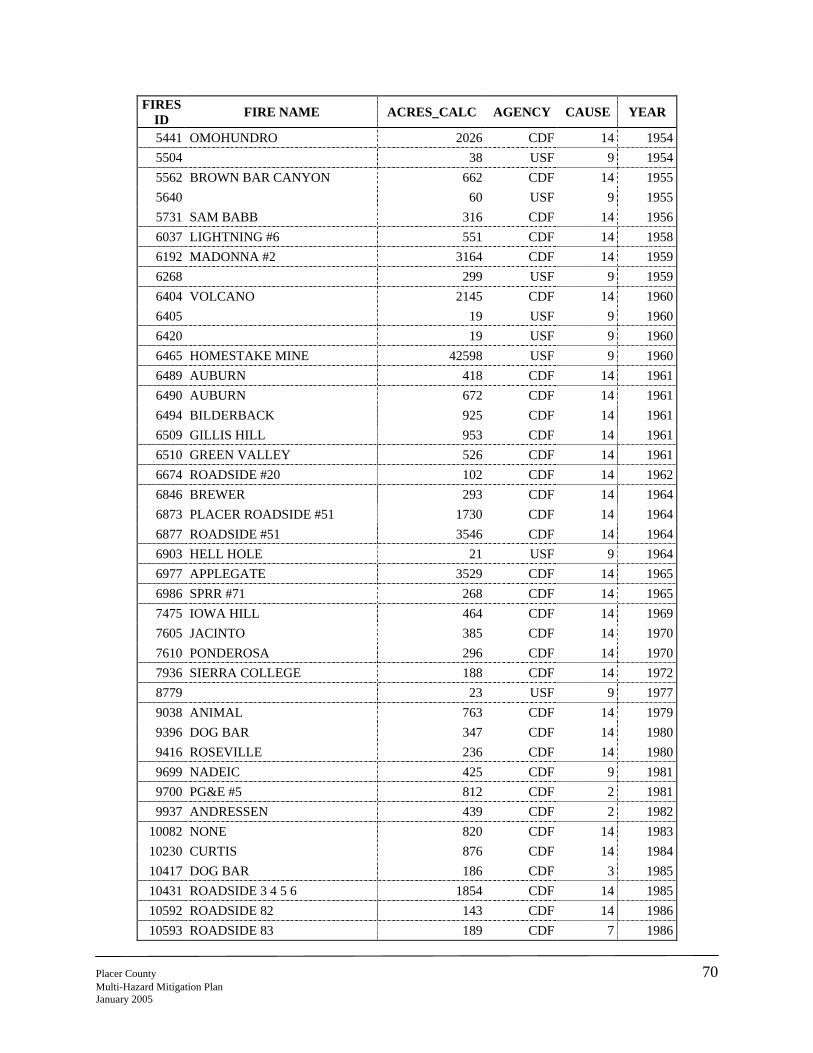
FIRES ID FIRE NAME ACRES_CALC AGENCY CAUSE YEAR
5441 OMOHUNDRO 2026 CDF 14 19545504 38 USF 9 19545562 BROWN BAR CANYON 662 CDF 14 19555640 60 USF 9 19555731 SAM BABB 316 CDF 14 19566037 LIGHTNING #6 551 CDF 14 19586192 MADONNA #2 3164 CDF 14 19596268 299 USF 9 19596404 VOLCANO 2145 CDF 14 19606405 19 USF 9 19606420 19 USF 9 19606465 HOMESTAKE MINE 42598 USF 9 19606489 AUBURN 418 CDF 14 19616490 AUBURN 672 CDF 14 19616494 BILDERBACK 925 CDF 14 19616509 GILLIS HILL 953 CDF 14 19616510 GREEN VALLEY 526 CDF 14 19616674 ROADSIDE #20 102 CDF 14 19626846 BREWER 293 CDF 14 19646873 PLACER ROADSIDE #51 1730 CDF 14 19646877 ROADSIDE #51 3546 CDF 14 19646903 HELL HOLE 21 USF 9 19646977 APPLEGATE 3529 CDF 14 19656986 SPRR #71 268 CDF 14 19657475 IOWA HILL 464 CDF 14 19697605 JACINTO 385 CDF 14 19707610 PONDEROSA 296 CDF 14 19707936 SIERRA COLLEGE 188 CDF 14 19728779 23 USF 9 19779038 ANIMAL 763 CDF 14 19799396 DOG BAR 347 CDF 14 19809416 ROSEVILLE 236 CDF 14 19809699 NADEIC 425 CDF 9 19819700 PG&E #5 812 CDF 2 19819937 ANDRESSEN 439 CDF 2 1982
10082 NONE 820 CDF 14 198310230 CURTIS 876 CDF 14 198410417 DOG BAR 186 CDF 3 198510431 ROADSIDE 3 4 5 6 1854 CDF 14 198510592 ROADSIDE 82 143 CDF 14 198610593 ROADSIDE 83 189 CDF 7 1986
Placer County 70 Multi-Hazard Mitigation Plan January 2005
FIRES ID FIRE NAME ACRES_CALC AGENCY CAUSE YEAR
10594 ROADSIDE 84 65 CDF 14 198610636 551 USF 9 198610640 2040 USF 14 198610738 CONOUCK 183 CDF 2 198710833 18 USF 1 198710834 891 USF 1 198711065 29 USF 9 198811237 15 USF 9 198911241 9 USF 1 198912140 626 USF 9 199512188 HELESTER 482 USF 9 199513019 DRIVERS 348 CDF 3 200013020 AMERICAN 148 CDF 14 200013047 DEADWOOD 95 USF 2 200013612 243 USF 14 194413706 BLUE OAKS 1427 CDF 9 200113707 WHITNEY 142 CDF 14 200113708 MARTIS 14126 CDF 4 200113709 LINCOLN CITY ASST 372 CDF 7 200113710 PONDEROSA 2777 CDF 10 200113711 GAP-CATNF14107 2462 USF 4 200113942 SIERRA 594 CDF 10 200213943 PONDEROSA 46 CDF 7 200213945 GARDEN 284 CDF 11 200214007 STAR 16464 USF 9 200114366 SIERRA 26 CDF 10 200314367 VALLEY 52 CDF 5 200314368 PINES 38 CDF 7 200314929 ROYAL 338 USF 5 200314935 COD FISH 841 USF 1 2003
Source: California Department of Forestry and Fire Protection 2003 Fire Perimeters GIS coverage. (The AGENCY attribute in the fires subclass is currently populated with the agency who supplied that particular incident.)
It is important to note, that in addition to the Placer County fire history detailed in the above tables and map, there are numerous smaller fires that occur in the area year after year, many of these a result of “roadside spots” along I-80. These smaller fires also have the ability to quickly get out of hand and become significant fires (e.g., the 2002 Sierra Fire). Also, small fires in acreage can result in large losses. A fire in the Heather Glen area in 2000 was only 10 acres, but resulted in $350,000 in damages because a home was lost.
Placer County 71 Multi-Hazard Mitigation Plan January 2005
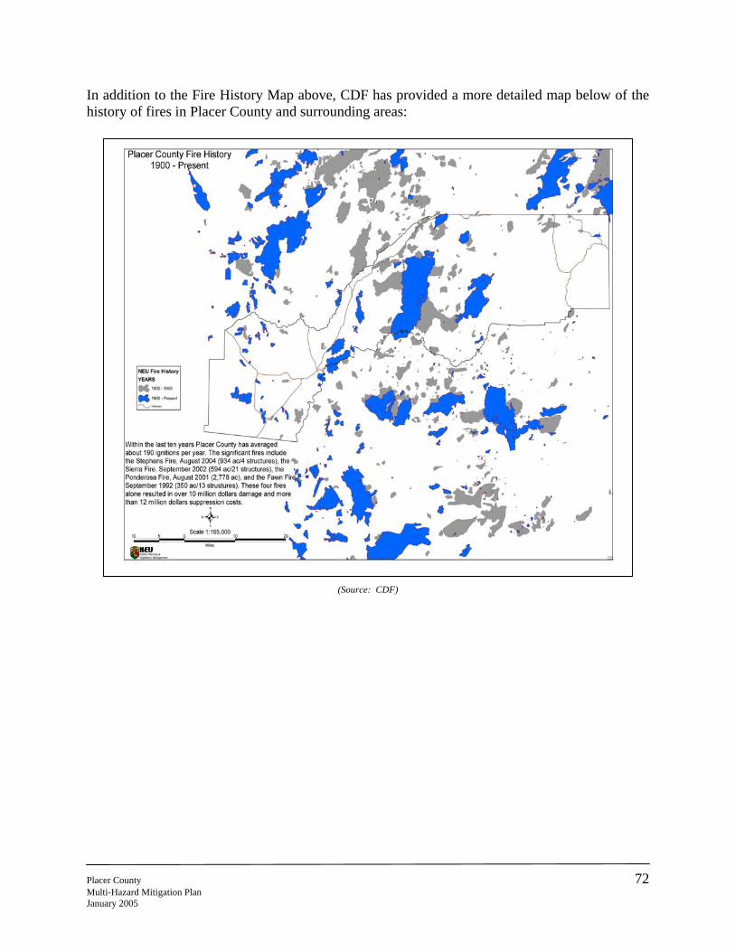
In addition to the Fire History Map above, CDF has provided a more detailed map below of the history of fires in Placer County and surrounding areas:
PlaceMultJanua
(Source: CDF)
r County 72 i-Hazard Mitigation Plan ry 2005
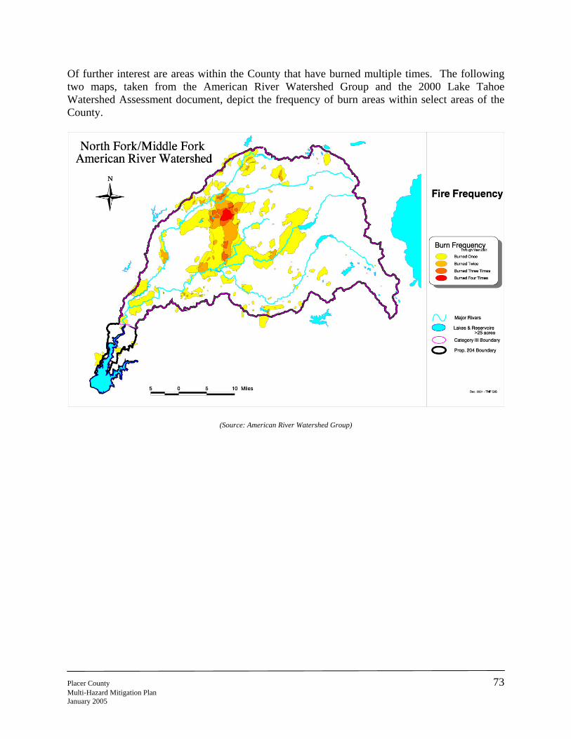
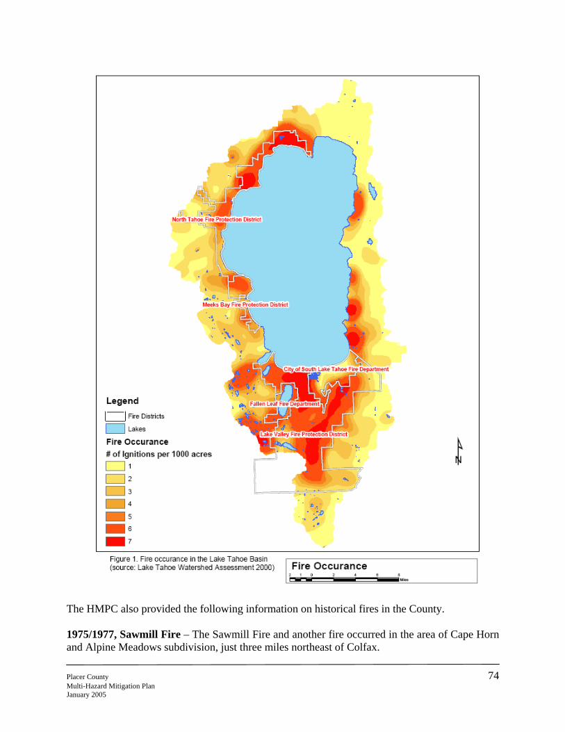
Of further interest are areas within the County that have burned multiple times. The following two maps, taken from the American River Watershed Group and the 2000 Lake Tahoe Watershed Assessment document, depict the frequency of burn areas within select areas of the County.
(Source: American River Watershed Group)
Placer County 73 Multi-Hazard Mitigation Plan January 2005
The HMPC also provided the following information on historical fires in the County. 1975/1977, Sawmill Fire – The Sawmill Fire and another fire occurred in the area of Cape Horn and Alpine Meadows subdivision, just three miles northeast of Colfax. Placer County 74 Multi-Hazard Mitigation Plan January 2005
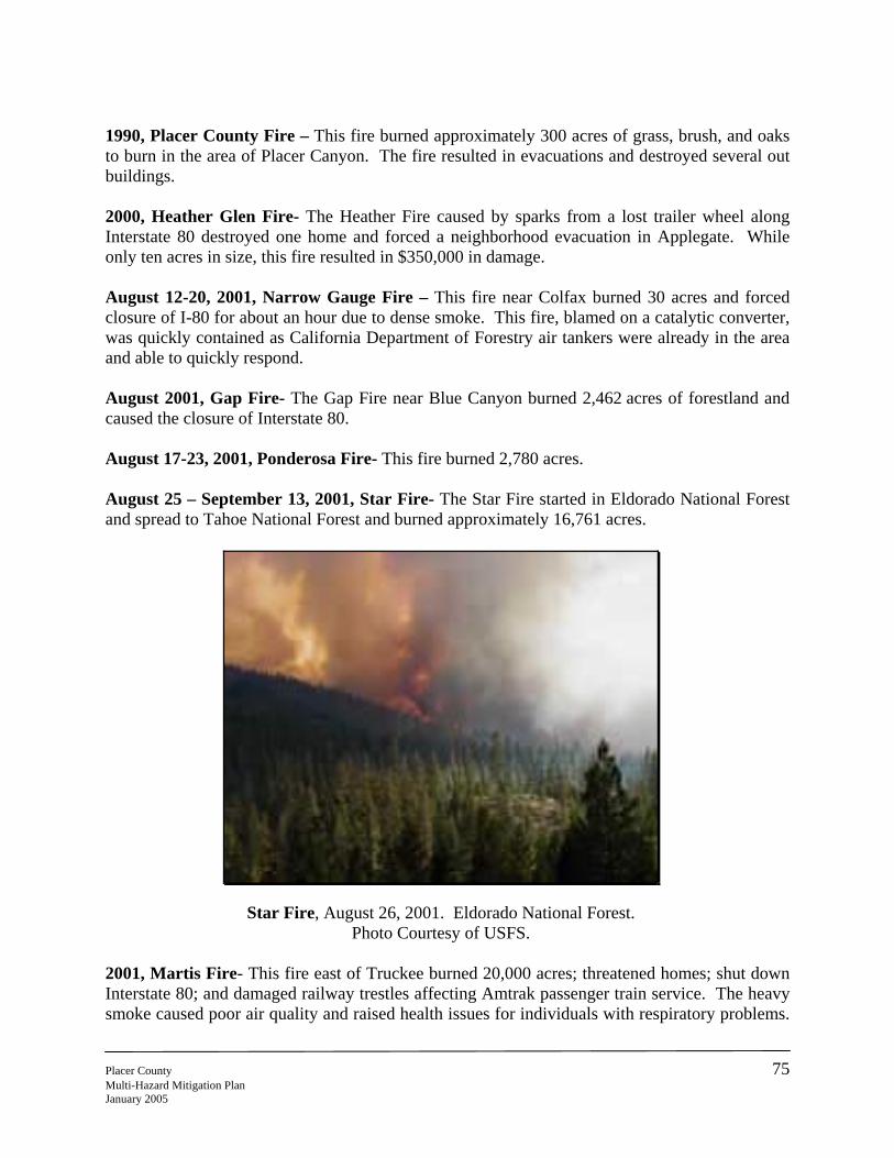
1990, Placer County Fire – This fire burned approximately 300 acres of grass, brush, and oaks to burn in the area of Placer Canyon. The fire resulted in evacuations and destroyed several out buildings. 2000, Heather Glen Fire- The Heather Fire caused by sparks from a lost trailer wheel along Interstate 80 destroyed one home and forced a neighborhood evacuation in Applegate. While only ten acres in size, this fire resulted in $350,000 in damage. August 12-20, 2001, Narrow Gauge Fire – This fire near Colfax burned 30 acres and forced closure of I-80 for about an hour due to dense smoke. This fire, blamed on a catalytic converter, was quickly contained as California Department of Forestry air tankers were already in the area and able to quickly respond. August 2001, Gap Fire- The Gap Fire near Blue Canyon burned 2,462 acres of forestland and caused the closure of Interstate 80. August 17-23, 2001, Ponderosa Fire- This fire burned 2,780 acres. August 25 – September 13, 2001, Star Fire- The Star Fire started in Eldorado National Forest and spread to Tahoe National Forest and burned approximately 16,761 acres.
Star Fire, August 26, 2001. Eldorado National Forest. Photo Courtesy of USFS.
2001, Martis Fire- This fire east of Truckee burned 20,000 acres; threatened homes; shut down Interstate 80; and damaged railway trestles affecting Amtrak passenger train service. The heavy smoke caused poor air quality and raised health issues for individuals with respiratory problems.
Placer County 75 Multi-Hazard Mitigation Plan January 2005
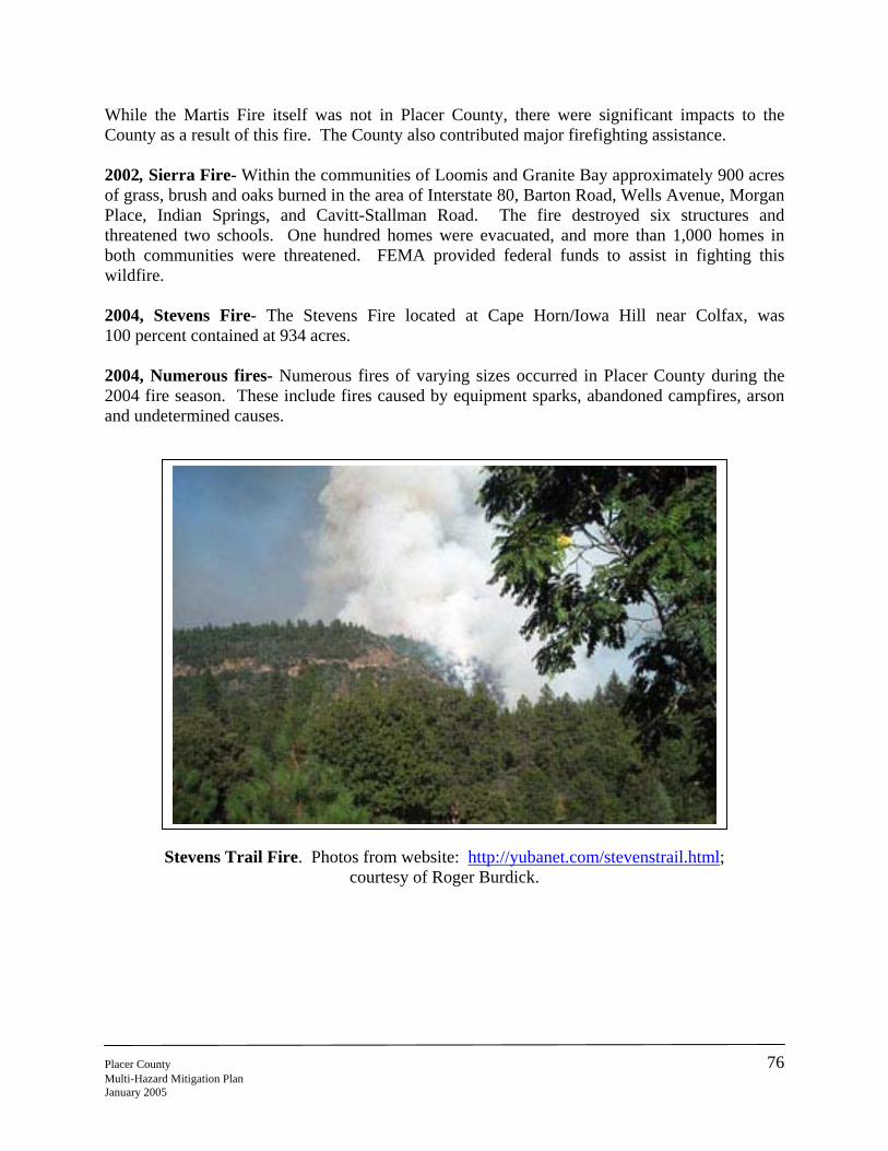
While the Martis Fire itself was not in Placer County, there were significant impacts to the County as a result of this fire. The County also contributed major firefighting assistance. 2002, Sierra Fire- Within the communities of Loomis and Granite Bay approximately 900 acres of grass, brush and oaks burned in the area of Interstate 80, Barton Road, Wells Avenue, Morgan Place, Indian Springs, and Cavitt-Stallman Road. The fire destroyed six structures and threatened two schools. One hundred homes were evacuated, and more than 1,000 homes in both communities were threatened. FEMA provided federal funds to assist in fighting this wildfire. 2004, Stevens Fire- The Stevens Fire located at Cape Horn/Iowa Hill near Colfax, was 100 percent contained at 934 acres. 2004, Numerous fires- Numerous fires of varying sizes occurred in Placer County during the 2004 fire season. These include fires caused by equipment sparks, abandoned campfires, arson and undetermined causes.
Placer CountMulti-HazardJanuary 2005
Stevens Trail Fire. Photos from website: http://yubanet.com/stevenstrail.html; courtesy of Roger Burdick.
y 76 Mitigation Plan
Ste
Although htwo proclathe followi
Placer County Multi-Hazard MJanuary 2005
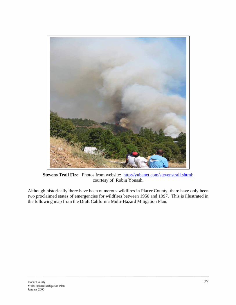
vens Trail Fire. Photos from website: http://yubanet.com/stevenstrail.shtml; courtesy of Robin Yonash.
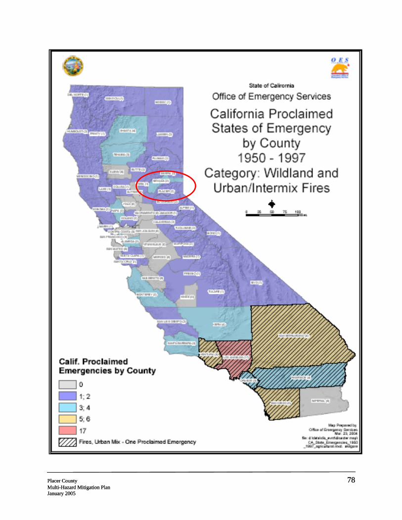
istorically there have been numerous wildfires in Placer County, there have only been imed states of emergencies for wildfires between 1950 and 1997. This is illustrated in ng map from the Draft California Multi-Hazard Mitigation Plan.
77 itigation Plan
Placer County 78 Multi-Hazard Mitigation Plan January 2005
Placer County 78 Multi-Hazard Mitigation Plan January 2005