Embed Size (px)
Citation preview
3-27
Basin Characteristics: Wildlife and Wildlife Habitat
Wildlife and Wildlife HabitatThe area provides diverse habitat including sagebrush steppe, riparian and wetlands, plus aspen and juniper woodlands. Wildlife species utilizing the habitat include upland game bird species, Rocky Mountain elk (Cervus elaphus nelsoni), mule deer (Odocoileus hemionus Rafinesque), pronghorn (Antilocapra americana), California bighorn sheep (Ovis canadensis californiana), cougars (Puma concolor L.), raptors, waterfowl, shorebirds, wading birds, migratory birds, reptiles, amphibians, and invertebrates. The following section describes the major wildlife species and habitat found in the area.
Wildlife
Mule Deer
Mule deer are widespread throughout the area. They are typically associated with complex mid- to upper elevation plant communities supporting a wide variety of sagebrush, mountain shrubs, aspen, juniper, and herbaceous vegetation. Mule deer browse on shrubs and forbs, which provide most of their annual diet.
Thermal cover is critical on winter range to provide protection from wind and other adverse elements. Grassy slopes, meadows, brush fields, and other early successional stages (artificially created and otherwise) provide the majority of deer forage. During hot summer weather, aspen stands and juniper/big sagebrush/antelope bitterbrush shrublands function as thermal cover, reducing heat stress on the animals.
There are two transition ranges, spring and fall. The vegetation of the spring transition range is similar to winter range and consists of sagebrush and juniper woodland. Grasses and forbs are important components of the spring transitional ranges. The vegetation of the fall transitional ranges is similar to summer ranges and consist primarily of aspen, shrub steppe, and juniper woodland communities. Maintaining migratory routes is critical to the seasonal deer movements.
The winter range occurs primarily in juniper woodland and sagebrush communities with interspersed grasses. Shrubs are a major component of the winter diet, primarily antelope bitterbrush, big sagebrush, curl-leaf mountain mahogany, and western juniper. When snow conditions make higher elevations unsuitable, deer will move to suitable habitat in lower elevations. Deer tend to remain at the highest possible elevations until forced to winter concentration areas by snowfall.
Mule deer numbers have been lower than management objective levels for several years. The decline in population numbers is probably due to a combination of factors including but not limited to drought, predators and winter range condition.
3-28
Guano & Thousand-Virgin Sub-basins Watershed Assessment
Pronghorn
Found throughout the area are Pronghorn. Winter range for pronghorn is concentrated in the southeast end of the Pueblo Mountains, the Fields area, and along the eastern base of Steens Mountain. During the summer, pronghorn are widely distributed throughout the area in habitats having low structure and a mixture of grasses, forbs, and shrubs. They use sagebrush for both cover and forage. Seedings and wildland fires have converted some previously dense stands of sagebrush into suitable range.
Livestock water developments, including pipelines, have allowed pronghorn to expand into formerly unoccupied areas. Forage competition with cattle and wild horses is slight due to forage preferences (Vavra and Sneva, 1978). Pronghorns have been observed coming to water with feral horses, and believed that horses provided some sense of security (Trainer et al 1984). Lack of water at natural or developed sites can be a serious problem during periods of drought. BLM fence construction specifications allow pronghorn to move freely by having smooth bottom wires spaced at least 16 inches above ground level.
Migratory Birds
The area supports a variety of migratory bird species that breed in the United States and winter in Central or South America. Populations of some of these species are declining because of global land use practices and other factors. Migratory birds exhibit variable habitat requirements and are found in all habitat types.
Waterfowl and Shorebirds
Many species of waterfowl, shorebirds, and wading birds may use the area due to the nearby wetland habitat of the Malheur NWR and private lands. Representative species include Canada goose (Branta canadensis), cinnamon teal (Anas cynoptera), mallard (Anas platyrhynchos), gadwall (Anas strepera), American avocet (Recurvirostra americana), white-faced ibis (Plegadis chihi Vieillot), Wilson’s phalarope (Phalaropus tricolor Vieillot), greater sandhill crane (Grus canadensis), great blue heron (Ardea herodias), and spotted sandpiper (Actitis macularius L.). These species exhibit variable habitat requirements and are found in several habitat types.
Chukar
Chukars (Alectoris chukar ( J. E. Gray))are one of the main upland game bird species found in the sub-basin. They inhabit sparsely vegetated rocky canyons, slopes, and hillsides and can be found in sagebrush flats, grasslands and open juniper canyon lands. Chukars are an introduced species to Oregon and are primarily a seed eater with cheatgrass seed being a favored food. Insects may also be part of the adult diet but chick diets may consist largely of insects. Seasonal use areas vary with climatic conditions and the availability of water.
Wildlife Habitat
The sagebrush steppe includes several upland vegetation communities with a shrubland character and a variable understory of grasses and forbs. The presence of a shrub overstory is associated with wildlife community diversity.
3-29
Basin Characteristics: Wildlife and Wildlife Habitat
Shrubby plants are important to most small and large wildlife because they supply food as well as hiding cover and structure. Within the sagebrush steppe community, grasses and forbs provide food and cover for wildlife. Habitats that provide a mix of grasses and forbs meet the needs of a wide range of species.
Riparian areas consist of plant communities associated with streams and rivers. The structure, food, and water available in these areas make them the single most diverse and productive wildlife habitat. Well-developed riparian areas with trees, shrubs, grasses, forbs, sedges, and rushes provide valuable habitat for a wide array of wildlife species. Wetlands, either consisting of permanently or seasonally wet areas, are associated with various landscape settings including reservoirs, sloughs, playas, meadows, springs, and seeps. Wetlands typically provide succulent green forage, insects, and drinking water for wildlife. Riparian and wetland areas that do not support diverse plant communities still provide important sources of water and food for wildlife.
The juniper woodlands provide habitat for a large number of species supported within the area. These woodlands vary greatly in their habitat value depending on factors such as height, density, and age of trees. Older trees may provide cavities for nesting birds while deer use juniper for thermal and escape cover. The distribution of juniper (normally between 5700 to 6560 feet elevation) influences the condition and quality of neighboring wildlife habitat.
Special Status Animal Species
Pygmy Rabbit
The pygmy rabbit (Brachylagus idahoensis) is a member of the family Leporidae, which includes hares and rabbits and it is the only species in the monotypic genus Brachylagus. It is the smallest rabbit in North America, and one of the smallest leporids in the world (Katzner and Parker 1997). It weighs around one pound, can fit in the palm of a hand, and is one of only two North American rabbits that dig its own burrows. The pygmy rabbit is uniquely dependent on sagebrush, which comprises up to 99% of its winter diet. It is strictly sagebrush obligate, inhabiting sagebrush dominated habitats in the Intermountain Region and Great Basin. The historical range of the pygmy rabbit encompassed more than 100 million acres in eight western states (Montana, Idaho, Wyoming, Utah, Nevada, California, Oregon and Washington). Pygmy rabbits are one of a very few species, including pronghorn and Sage-grouse (Centrocercus urophasianus), that can ingest large amounts of sagebrush leaves laden with terpenoids without major digestive disturbances and death (Katzner 1994). This combination of small body size, specialized feeding strategies, and unique habitat requirements are unusual among leporids. Pygmy rabbits have the greatest surface area to volume ratio (and thus heat loss) of any rabbit species in their known geographic range and endure harsh climatic extremes characterized by cold winters and dry summers where drought is common (Katzner 1994).
Pygmy rabbits are slow and vulnerable to predators in open areas. They elude predators by maneuvering in dense shrub cover. Big sagebrush provides both essential year-round food and critical protection from predation. Habitat fragmentation readily isolates populations, as disruptions in sagebrush cover and open areas provide barriers to dispersal. The pygmy rabbit has very limited dispersal abilities and is reluctant to cross open areas, amplifying the effects of fragmentation. Pygmy rabbit home range and use areas may vary seasonally, as well as, in relation to food availability and habitat condition. Home
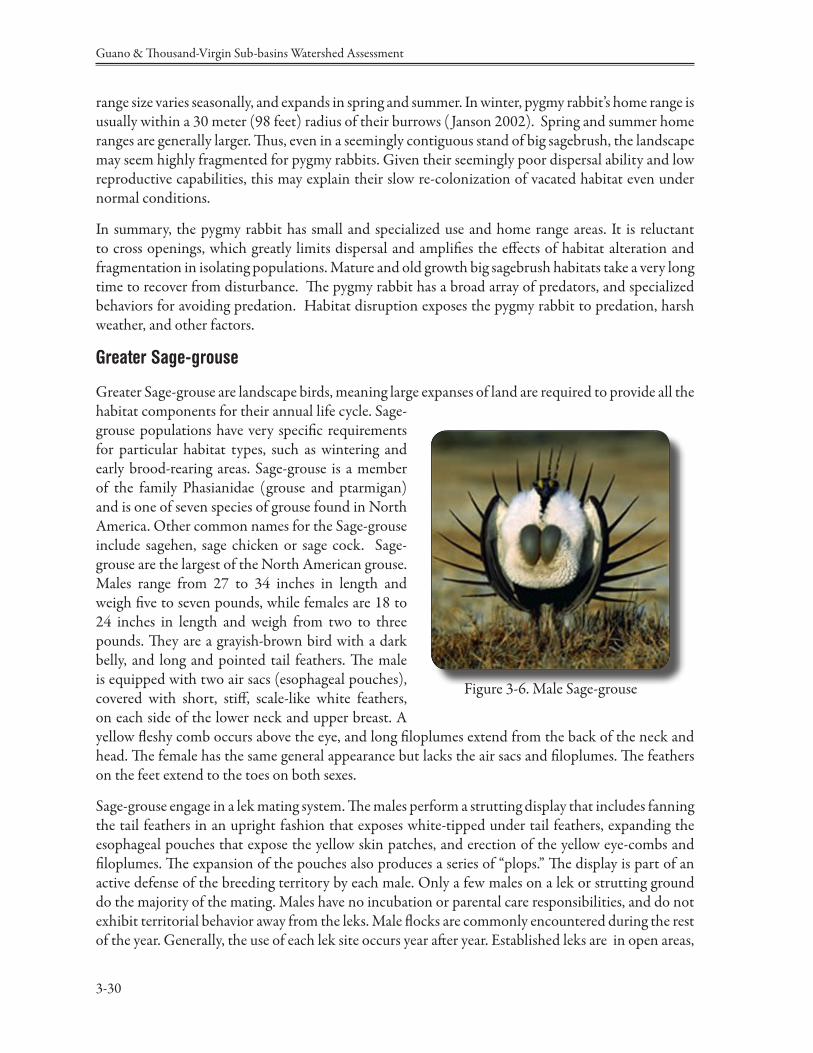
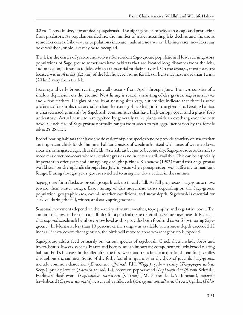
Figure 3-6. Male Sage-grouse
3-30
Guano & Thousand-Virgin Sub-basins Watershed Assessment
range size varies seasonally, and expands in spring and summer. In winter, pygmy rabbit’s home range is usually within a 30 meter (98 feet) radius of their burrows ( Janson 2002). Spring and summer home ranges are generally larger. Thus, even in a seemingly contiguous stand of big sagebrush, the landscape may seem highly fragmented for pygmy rabbits. Given their seemingly poor dispersal ability and low reproductive capabilities, this may explain their slow re-colonization of vacated habitat even under normal conditions.
In summary, the pygmy rabbit has small and specialized use and home range areas. It is reluctant to cross openings, which greatly limits dispersal and amplifies the effects of habitat alteration and fragmentation in isolating populations. Mature and old growth big sagebrush habitats take a very long time to recover from disturbance. The pygmy rabbit has a broad array of predators, and specialized behaviors for avoiding predation. Habitat disruption exposes the pygmy rabbit to predation, harsh weather, and other factors.
Greater Sage-grouse
Greater Sage-grouse are landscape birds, meaning large expanses of land are required to provide all the habitat components for their annual life cycle. Sage-grouse populations have very specific requirements for particular habitat types, such as wintering and early brood-rearing areas. Sage-grouse is a member of the family Phasianidae (grouse and ptarmigan) and is one of seven species of grouse found in North America. Other common names for the Sage-grouse include sagehen, sage chicken or sage cock. Sage-grouse are the largest of the North American grouse. Males range from 27 to 34 inches in length and weigh five to seven pounds, while females are 18 to 24 inches in length and weigh from two to three pounds. They are a grayish-brown bird with a dark belly, and long and pointed tail feathers. The male is equipped with two air sacs (esophageal pouches), covered with short, stiff, scale-like white feathers, on each side of the lower neck and upper breast. A yellow fleshy comb occurs above the eye, and long filoplumes extend from the back of the neck and head. The female has the same general appearance but lacks the air sacs and filoplumes. The feathers on the feet extend to the toes on both sexes.
Sage-grouse engage in a lek mating system. The males perform a strutting display that includes fanning the tail feathers in an upright fashion that exposes white-tipped under tail feathers, expanding the esophageal pouches that expose the yellow skin patches, and erection of the yellow eye-combs and filoplumes. The expansion of the pouches also produces a series of “plops.” The display is part of an active defense of the breeding territory by each male. Only a few males on a lek or strutting ground do the majority of the mating. Males have no incubation or parental care responsibilities, and do not exhibit territorial behavior away from the leks. Male flocks are commonly encountered during the rest of the year. Generally, the use of each lek site occurs year after year. Established leks are in open areas,
3-31
Basin Characteristics: Wildlife and Wildlife Habitat
0.2 to 12 acres in size, surrounded by sagebrush. The big sagebrush provides an escape and protection from predators. As populations decline, the number of males attending leks decline and the use at some leks ceases. Likewise, as populations increase, male attendance on leks increases, new leks may be established, or old leks may be re-occupied.
The lek is the center of year-round activity for resident Sage-grouse populations. However, migratory populations of Sage-grouse sometimes have habitats that are located long distances from the leks, and move long distances to leks, which are essential to their survival. On the average, most nests are located within 4 miles (6.2 km) of the lek; however, some females or hens may nest more than 12 mi. (20 km) away from the lek.
Nesting and early brood rearing generally occurs from April through June. The nest consists of a shallow depression on the ground. Nest lining is sparse, consisting of dry grasses, sagebrush leaves and a few feathers. Heights of shrubs at nesting sites vary, but studies indicate that there is some preference for shrubs that are taller than the average shrub height for the given site. Nesting habitat is characterized primarily by Sagebrush communities that have high canopy cover and a grass/ forb understory. Actual nest sites are typified by generally taller plants with an overhang over the nest bowl. Clutch size of Sage-grouse normally ranges from seven to ten eggs. Incubation by the female takes 25-28 days.
Brood-rearing habitats that have a wide variety of plant species tend to provide a variety of insects that are important chick foods. Summer habitat consists of sagebrush mixed with areas of wet meadows, riparian, or irrigated agricultural fields. As a habitat begins to become dry, Sage-grouse broods shift to more mesic wet meadows where succulent grasses and insects are still available. This can be especially important in drier years and during long drought periods. Klebenow (1982) found that Sage-grouse would stay on the uplands through late July in years when precipitation was sufficient to maintain forage. During drought years, grouse switched to using meadows earlier in the summer.
Sage-grouse form flocks as brood groups break up in early fall. As fall progresses, Sage-grouse move toward their winter ranges. Exact timing of this movement varies depending on the Sage-grouse population, geographic area, overall weather conditions, and snow depth. Sagebrush is essential for survival during the fall, winter, and early spring months.
Seasonal movements depend on the severity of winter weather, topography, and vegetative cover. The amount of snow, rather than an affinity for a particular site determines winter use areas. It is crucial that exposed sagebrush be above snow level as this provides both food and cover for wintering Sage-grouse. In Montana, less than 10 percent of the range was available when snow depth exceeded 12 inches. If snow covers the sagebrush, the birds will move to areas where sagebrush is exposed.
Sage-grouse adults feed primarily on various species of sagebrush. Chick diets include forbs and invertebrates. Insects, especially ants and beetles, are an important component of early brood-rearing habitat. Forbs increase in the diet after the first week and remain the major food item for juveniles throughout the summer. Some of the forbs found in quantity in the diets of juvenile Sage-grouse include common dandelion (Taraxacum officinale F.H. Wigg.), yellow salsify (Tragopogon dubius Scop.), prickly lettuce (Lactuca serriola L.), common pepperweed (Lepidium densiflorum Schrad.), Harkness’ flaxflower (Leptosiphon harknessii (Curran) J.M. Porter & L.A. Johnson), tapertip hawksbeard (Crepis acuminata), lesser rushy milkvetch (Astragalus convallarius Greene), phlox (Phlox
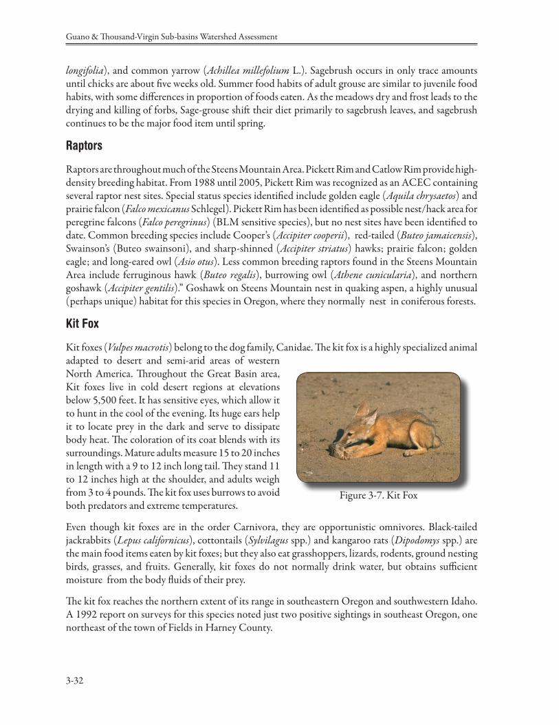
Figure 3-7. Kit Fox
3-32
Guano & Thousand-Virgin Sub-basins Watershed Assessment
longifolia), and common yarrow (Achillea millefolium L.). Sagebrush occurs in only trace amounts until chicks are about five weeks old. Summer food habits of adult grouse are similar to juvenile food habits, with some differences in proportion of foods eaten. As the meadows dry and frost leads to the drying and killing of forbs, Sage-grouse shift their diet primarily to sagebrush leaves, and sagebrush continues to be the major food item until spring.
Raptors
Raptors are throughout much of the Steens Mountain Area. Pickett Rim and Catlow Rim provide high-density breeding habitat. From 1988 until 2005, Pickett Rim was recognized as an ACEC containing several raptor nest sites. Special status species identified include golden eagle (Aquila chrysaetos) and prairie falcon (Falco mexicanus Schlegel). Pickett Rim has been identified as possible nest/hack area for peregrine falcons (Falco peregrinus) (BLM sensitive species), but no nest sites have been identified to date. Common breeding species include Cooper’s (Accipiter cooperii), red-tailed (Buteo jamaicensis), Swainson’s (Buteo swainsoni), and sharp-shinned (Accipiter striatus) hawks; prairie falcon; golden eagle; and long-eared owl (Asio otus). Less common breeding raptors found in the Steens Mountain Area include ferruginous hawk (Buteo regalis), burrowing owl (Athene cunicularia), and northern goshawk (Accipiter gentilis).” Goshawk on Steens Mountain nest in quaking aspen, a highly unusual (perhaps unique) habitat for this species in Oregon, where they normally nest in coniferous forests.
Kit Fox
Kit foxes (Vulpes macrotis) belong to the dog family, Canidae. The kit fox is a highly specialized animal adapted to desert and semi-arid areas of western North America. Throughout the Great Basin area, Kit foxes live in cold desert regions at elevations below 5,500 feet. It has sensitive eyes, which allow it to hunt in the cool of the evening. Its huge ears help it to locate prey in the dark and serve to dissipate body heat. The coloration of its coat blends with its surroundings. Mature adults measure 15 to 20 inches in length with a 9 to 12 inch long tail. They stand 11 to 12 inches high at the shoulder, and adults weigh from 3 to 4 pounds. The kit fox uses burrows to avoid both predators and extreme temperatures.
Even though kit foxes are in the order Carnivora, they are opportunistic omnivores. Black-tailed jackrabbits (Lepus californicus), cottontails (Sylvilagus spp.) and kangaroo rats (Dipodomys spp.) are the main food items eaten by kit foxes; but they also eat grasshoppers, lizards, rodents, ground nesting birds, grasses, and fruits. Generally, kit foxes do not normally drink water, but obtains sufficient moisture from the body fluids of their prey.
The kit fox reaches the northern extent of its range in southeastern Oregon and southwestern Idaho. A 1992 report on surveys for this species noted just two positive sightings in southeast Oregon, one northeast of the town of Fields in Harney County.
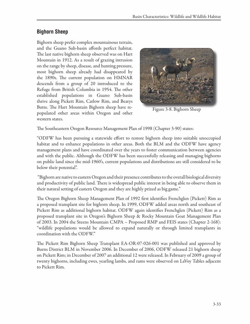
Figure 3-8. Bighorn Sheep
3-33
Basin Characteristics: Wildlife and Wildlife Habitat
Bighorn Sheep
Bighorn sheep prefer complex mountainous terrain, and the Guano Sub-basin affords perfect habitat. The last native bighorn sheep observed was on Hart Mountain in 1912. As a result of grazing intrusion on the range by sheep, disease, and hunting pressure, most bighorn sheep already had disappeared by the 1890s. The current population on HMNAR descends from a group of 20 introduced to the Refuge from British Columbia in 1954. The other established populations in Guano Sub-basin thrive along Pickett Rim, Catlow Rim, and Beatys Butte. The Hart Mountain Bighorn sheep have re-populated other areas within Oregon and other western states.
The Southeastern Oregon Resource Management Plan of 1998 (Chapter 3-90) states:
“ODFW has been pursuing a statewide effort to restore bighorn sheep into suitable unoccupied habitat and to enhance populations in other areas. Both the BLM and the ODFW have agency management plans and have coordinated over the years to foster communication between agencies and with the public. Although the ODFW has been successfully releasing and managing bighorns on public land since the mid-1960’s, current populations and distributions are still considered to be below their potential”.
“Bighorn are native to eastern Oregon and their presence contributes to the overall biological diversity and productivity of public land. There is widespread public interest in being able to observe them in their natural setting of eastern Oregon and they are highly prized as big game.”
The Oregon Bighorn Sheep Management Plan of 1992 first identifies Frenchglen (Pickett) Rim as a proposed transplant site for bighorn sheep. In 1999, ODFW added areas north and southeast of Pickett Rim as additional bighorn habitat. ODFW again identifies Frenchglen (Pickett) Rim as a proposed transplant site in Oregon’s Bighorn Sheep & Rocky Mountain Goat Management Plan of 2003. In 2004 the Steens Mountain CMPA – Proposed RMP and FEIS states (Chapter 2-168): “wildlife populations would be allowed to expand naturally or through limited transplants in coordination with the ODFW.”
The Pickett Rim Bighorn Sheep Transplant EA-OR-07-026-001 was published and approved by Burns District BLM in November 2006. In December of 2006, ODFW released 21 bighorn sheep on Pickett Rim; in December of 2007 an additional 12 were released. In February of 2009 a group of twenty bighorns, including ewes, yearling lambs, and rams were observed on LaVoy Tables adjacent to Pickett Rim.
3-34
Guano & Thousand-Virgin Sub-basins Watershed Assessment
Wild or Feral Horses
The Wild Free-Roaming Horses and Burros Act of 1971 (PL 92-195), as amended, states: “It is the policy of Congress that wild free-roaming horses and burros shall be protected from capture, branding, harassment, or death; and to accomplish this they are to be considered in the area where presently found as an integral part of the Public Lands.” After passage of this act in 1971, the area was inventoried for free-roaming horses and burros, and Herd Management Areas (HMAs) were designated.
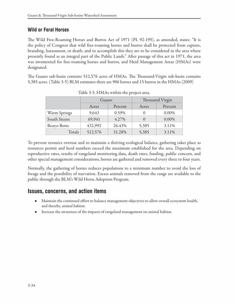
The Guano sub-basin contains 512,576 acres of HMAs. The Thousand-Virgin sub-basin contains 5,385 acres. (Table 3-5) BLM estimates there are 906 horses and 15 burros in the HMAs (2009)
Table 3-5. HMAs within the project area.
Guano Thousand VirginAcres Percent Acres Percent
Warm Springs 9,643 0.59% 0 0.00%South Steens 69,941 4.27% 0 0.00%Beatys Butte 432,992 26.43% 5,385 3.11%
Totals 512,576 31.28% 5,385 3.11%
To prevent resource overuse and to maintain a thriving ecological balance, gathering takes place as resources permit and herd numbers exceed the maximum established for the area. Depending on reproductive rates, results of rangeland monitoring data, death rates, funding, public concern, and other special management considerations, horses are gathered and removed every three to four years.
Normally, the gathering of horses reduces populations to a minimum number to avoid the loss of forage and the possibility of starvation. Excess animals removed from the range are available to the public through the BLM’s Wild Horse Adoption Program.
Issues, concerns, and action items• Maintain the continued effort to balance management objectives to allow overall ecosystem health,
and thereby, animal habitat.• Increase the awareness of the impacts of rangeland management on animal habitat.
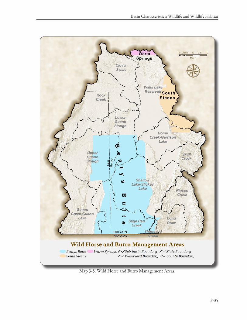
Map 3-5. Wild Horse and Burro Management Areas.
3-35
Basin Characteristics: Wildlife and Wildlife Habitat

3-36
Guano & Thousand-Virgin Sub-basins Watershed Assessment
3-37
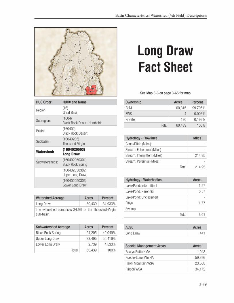
Basin Characteristics: Watershed (5th Field) Descriptions
Watershed (5th Field) DescriptionsIn this section, HCWC presents fact sheets for each of the thirteen watersheds located in the Guano and Thousand-Virgin sub-basins.
GIS data was used to generate all of the statistics in the data sheets.
GIS data was acquired from various Federal, State, and County sources. The data did not come in a single projection. As such, distance and area measurements differed between data sets. To overcome the projection differences, all data was converted to the Oregon Lambert projection and then calculated for distance and area. This step was done to provide consistent distance and area measurements.

3-38
Guano & Thousand-Virgin Sub-basins Watershed Assessment
3-39
Basin Characteristics: Watershed (5th Field) Descriptions
HUC Order HUC# and Name
Region:(16) Great Basin
Subregion:(1604) Black Rock Desert-Humboldt
Basin:(160402) Black Rock Desert
Subbasin:(16040205) Thousand-Virgin
Watershed: (1604020503) Long Draw
Subwatersheds:(160402050301) Black Rock Spring
(160402050302) Upper Long Draw
(160402050303) Lower Long Draw
Watershed Acreage Acres Percent
Long Draw 60,439 34.933%
The watershed comprises 34.9% of the Thousand-Virgin sub-basin.
Subwatershed Acreage Acres Percent
Black Rock Spring 24,205 40.049%
Upper Long Draw 33,495 55.419%
Lower Long Draw 2,739 4.533%
Total 60,439 100%
Ownership Acres Percent
BLM 60,315 99.795%
FWS 4 0.006%
Private 120 0.199%
Total 60,439 100%
Hydrology - Flowlines Miles
Canal/Ditch (Miles) -
Stream: Ephemeral (Miles) -
Stream: Intermittent (Miles) 214.95
Stream: Perennial (Miles) -
Total 214.95
Hydrology - Waterbodies Acres
Lake/Pond: Intermittent 1.27
Lake/Pond: Perennial 0.57
Lake/Pond: Unclassified -
Playa 1.77
Swamp -
Total 3.61
ACEC Acres
Long Draw 441
Special Management Areas Acres
Beatys Butte HMA 1,043
Pueblo-Lone Mtn HA 59,396
Hawk Mountain WSA 23,508
Rincon WSA 34,172
Long Draw Fact Sheet
See Map 3-6 on page 3-65 for map

3-40
Guano & Thousand-Virgin Sub-basins Watershed Assessment
Predominant Upland Vegetation
Acres Percent
Inter-Mountain Basins Big Sagebrush Steppe
43,313 34.933%
Inter-Mountain Basins Big Sagebrush Shrubland
9,588 15.86%
Columbia Plateau Steppe and Grassland
3,223 5.33%
Predominant Riparian Vegetation
Acres Percent
Inter-Mountain Basins Greasewood Flat
241 0.399%
Columbia Plateau Silver Sagebrush Seasonally Flooded Shrub-Steppe
150 0.249%
Elevation Extremes Feet
Unamed Point in Long Draw 4474
Hawks Mtn 7227
3-41
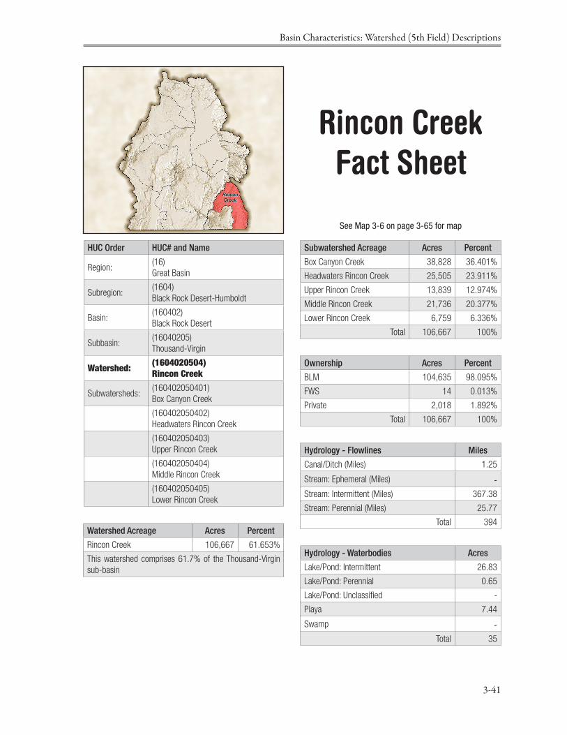
Basin Characteristics: Watershed (5th Field) Descriptions
HUC Order HUC# and Name
Region:(16) Great Basin
Subregion:(1604) Black Rock Desert-Humboldt
Basin:(160402) Black Rock Desert
Subbasin:(16040205) Thousand-Virgin
Watershed: (1604020504) Rincon Creek
Subwatersheds:(160402050401) Box Canyon Creek
(160402050402) Headwaters Rincon Creek
(160402050403) Upper Rincon Creek
(160402050404) Middle Rincon Creek
(160402050405) Lower Rincon Creek
Watershed Acreage Acres Percent
Rincon Creek 106,667 61.653%
This watershed comprises 61.7% of the Thousand-Virgin sub-basin
Subwatershed Acreage Acres Percent
Box Canyon Creek 38,828 36.401%
Headwaters Rincon Creek 25,505 23.911%
Upper Rincon Creek 13,839 12.974%
Middle Rincon Creek 21,736 20.377%
Lower Rincon Creek 6,759 6.336%
Total 106,667 100%
Ownership Acres Percent
BLM 104,635 98.095%
FWS 14 0.013%
Private 2,018 1.892%
Total 106,667 100%
Hydrology - Flowlines Miles
Canal/Ditch (Miles) 1.25
Stream: Ephemeral (Miles) -Stream: Intermittent (Miles) 367.38
Stream: Perennial (Miles) 25.77
Total 394
Hydrology - Waterbodies Acres
Lake/Pond: Intermittent 26.83
Lake/Pond: Perennial 0.65
Lake/Pond: Unclassified -
Playa 7.44
Swamp -Total 35
Rincon Creek Fact Sheet
See Map 3-6 on page 3-65 for map
3-42
Guano & Thousand-Virgin Sub-basins Watershed Assessment
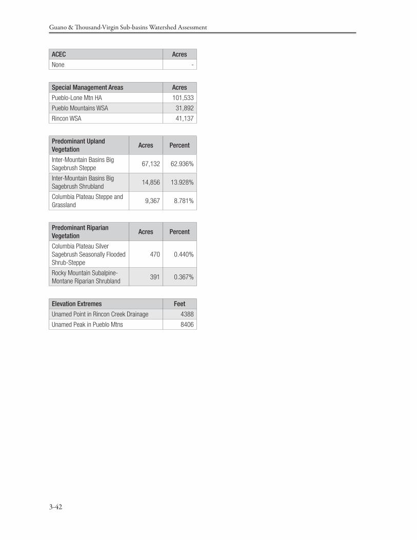
ACEC Acres
None -
Special Management Areas Acres
Pueblo-Lone Mtn HA 101,533
Pueblo Mountains WSA 31,892
Rincon WSA 41,137
Predominant Upland Vegetation
Acres Percent
Inter-Mountain Basins Big Sagebrush Steppe
67,132 62.936%
Inter-Mountain Basins Big Sagebrush Shrubland
14,856 13.928%
Columbia Plateau Steppe and Grassland
9,367 8.781%
Predominant Riparian Vegetation
Acres Percent
Columbia Plateau Silver Sagebrush Seasonally Flooded Shrub-Steppe
470 0.440%
Rocky Mountain Subalpine-Montane Riparian Shrubland
391 0.367%
Elevation Extremes Feet
Unamed Point in Rincon Creek Drainage 4388
Unamed Peak in Pueblo Mtns 8406
3-43
Basin Characteristics: Watershed (5th Field) Descriptions
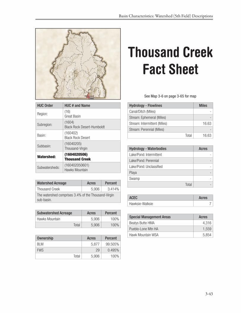
Thousand Creek Fact Sheet
HUC Order HUC # and Name
Region:(16) Great Basin
Subregion:(1604) Black Rock Desert-Humboldt
Basin:(160402) Black Rock Desert
Subbasin:(16040205) Thousand-Virgin
Watershed: (1604020506) Thousand Creek
Subwatersheds:(160402050601) Hawks Mountain
Watershed Acreage Acres Percent
Thousand Creek 5,906 3.414%
The watershed comprises 3.4% of the Thousand-Virgin sub-basin.
Subwatershed Acreage Acres Percent
Hawks Mountain 5,906 100%
Total 5,906 100%
Ownership Acres Percent
BLM 5,877 99.505%
FWS 29 0.495%
Total 5,906 100%
Hydrology - Flowlines Miles
Canal/Ditch (Miles) -
Stream: Ephemeral (Miles) -
Stream: Intermittent (Miles) 16.63
Stream: Perennial (Miles) -
Total 16.63
Hydrology - Waterbodies Acres
Lake/Pond: Intermittent -
Lake/Pond: Perennial -
Lake/Pond: Unclassified -
Playa -
Swamp -
Total -
ACEC Acres
Hawksie-Walksie 7
Special Management Areas Acres
Beatys Butte HMA 4,316
Pueblo-Lone Mtn HA 1,559
Hawk Mountain WSA 5,854
See Map 3-6 on page 3-65 for map
3-44
Guano & Thousand-Virgin Sub-basins Watershed Assessment
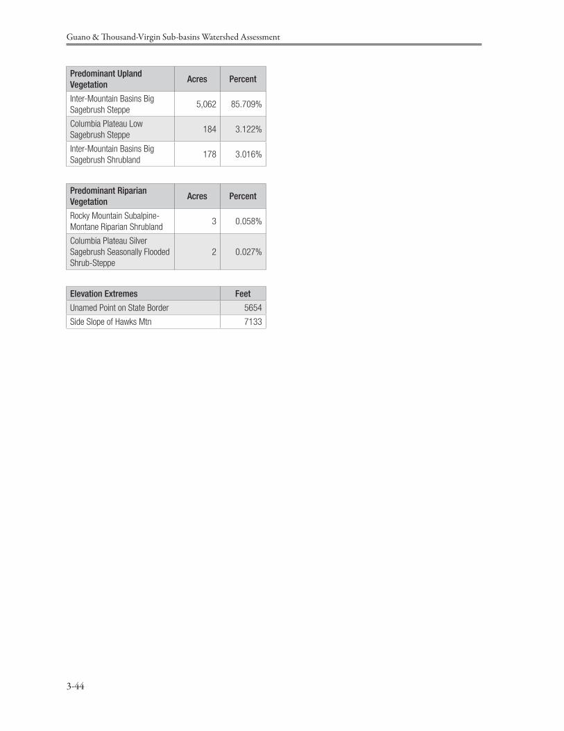
Predominant Upland Vegetation
Acres Percent
Inter-Mountain Basins Big Sagebrush Steppe
5,062 85.709%
Columbia Plateau Low Sagebrush Steppe
184 3.122%
Inter-Mountain Basins Big Sagebrush Shrubland
178 3.016%
Predominant Riparian Vegetation
Acres Percent
Rocky Mountain Subalpine-Montane Riparian Shrubland
3 0.058%
Columbia Plateau Silver Sagebrush Seasonally Flooded Shrub-Steppe
2 0.027%
Elevation Extremes Feet
Unamed Point on State Border 5654
Side Slope of Hawks Mtn 7133
3-45
Basin Characteristics: Watershed (5th Field) Descriptions
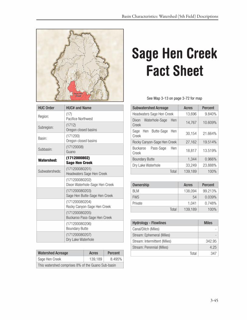
HUC Order HUC# and Name
Region:(17) Pacifice Northwest
Subregion:(1712) Oregon closed basins
Basin:(171200) Oregon closed basins
Subbasin:(17120008) Guano
Watershed: (1712000802) Sage Hen Creek
Subwatersheds:(171200080201) Headwaters Sage Hen Creek
(171200080202) Dixon Waterhole-Sage Hen Creek
(171200080203) Sage Hen Butte-Sage Hen Creek
(171200080204) Rocky Canyon-Sage Hen Creek
(171200080205) Buckaroo Pass-Sage Hen Creek
(171200080206) Boundary Butte
(171200080207) Dry Lake Waterhole
Watershed Acreage Acres Percent
Sage Hen Creek 139,189 8.495%
This watershed comprises 8% of the Guano Sub-basin
Subwatershed Acreage Acres Percent
Headwaters Sage Hen Creek 13,696 9.840%
Dixon Waterhole-Sage Hen Creek
14,767 10.609%
Sage Hen Butte-Sage Hen Creek
30,154 21.664%
Rocky Canyon-Sage Hen Creek 27,162 19.514%
Buckaroo Pass-Sage Hen Creek
18,817 13.519%
Boundary Butte 1,344 0.966%
Dry Lake Waterhole 33,249 23.888%
Total 139,189 100%
Ownership Acres Percent
BLM 138,094 99.213%
FWS 54 0.039%
Private 1,041 0.748%
Total 139,189 100%
Hydrology - Flowlines Miles
Canal/Ditch (Miles) -
Stream: Ephemeral (Miles) -
Stream: Intermittent (Miles) 342.95
Stream: Perennial (Miles) 4.25
Total 347
Sage Hen Creek Fact Sheet
See Map 3-13 on page 3-72 for map
3-46
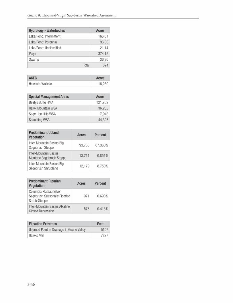
Guano & Thousand-Virgin Sub-basins Watershed Assessment
Hydrology - Waterbodies Acres
Lake/Pond: Intermittent 166.61
Lake/Pond: Perennial 96.00
Lake/Pond: Unclassified 21.14
Playa 374.15
Swamp 36.36
Total 694
ACEC Acres
Hawksie-Walksie 16,260
Special Management Areas Acres
Beatys Butte HMA 121,752
Hawk Mountain WSA 36,203
Sage Hen Hills WSA 7,948
Spaulding WSA 44,328
Predominant Upland Vegetation
Acres Percent
Inter-Mountain Basins Big Sagebrush Steppe
93,758 67.360%
Inter-Mountain Basins Montane Sagebrush Steppe
13,711 9.851%
Inter-Mountain Basins Big Sagebrush Shrubland
12,179 8.750%
Predominant Riparian Vegetation
Acres Percent
Columbia Plateau Silver Sagebrush Seasonally Flooded Shrub-Steppe
971 0.698%
Inter-Mountain Basins Alkaline Closed Depression
576 0.413%
Elevation Extremes Feet
Unamed Point in Drainage in Guano Valley 5197
Hawks Mtn 7227
3-47
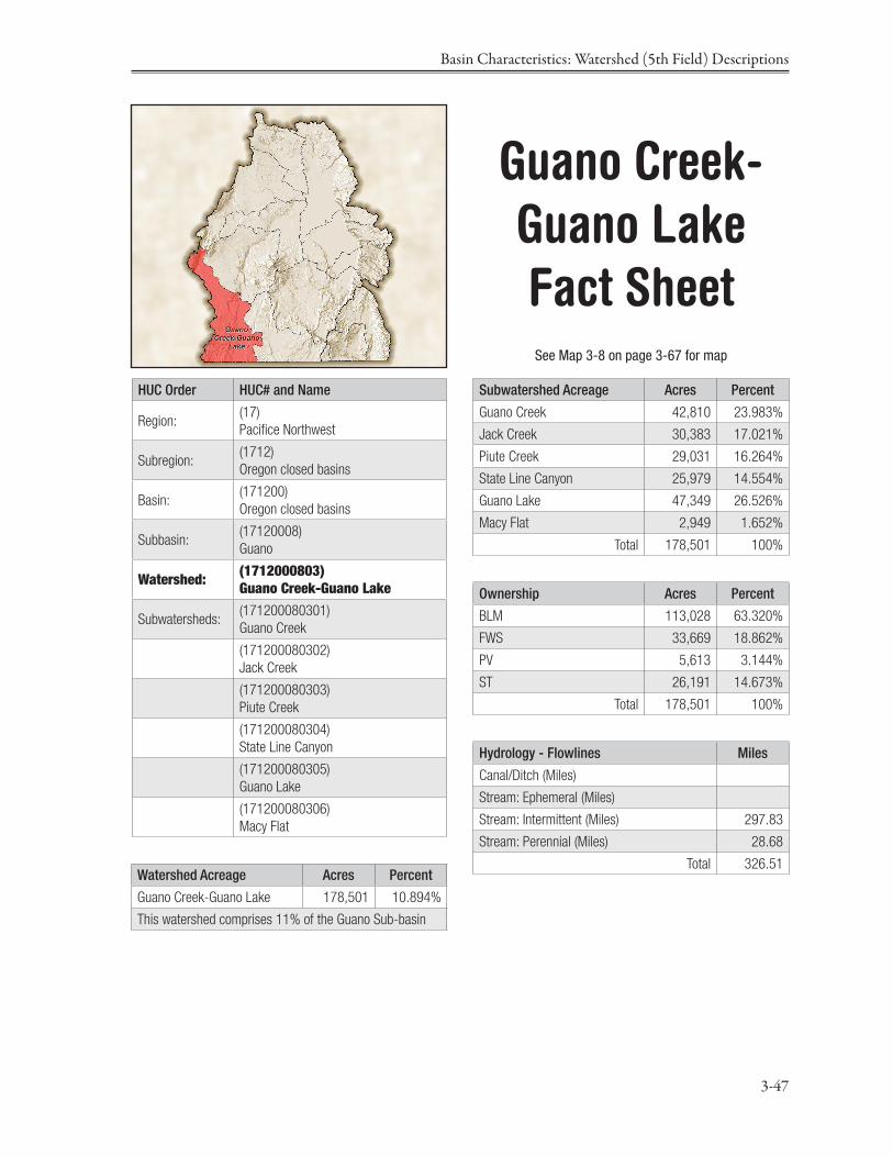
Basin Characteristics: Watershed (5th Field) Descriptions
HUC Order HUC# and Name
Region:(17) Pacifice Northwest
Subregion:(1712) Oregon closed basins
Basin:(171200) Oregon closed basins
Subbasin:(17120008) Guano
Watershed: (1712000803) Guano Creek-Guano Lake
Subwatersheds:(171200080301) Guano Creek
(171200080302) Jack Creek
(171200080303) Piute Creek
(171200080304) State Line Canyon
(171200080305) Guano Lake
(171200080306) Macy Flat
Watershed Acreage Acres Percent
Guano Creek-Guano Lake 178,501 10.894%
This watershed comprises 11% of the Guano Sub-basin
Subwatershed Acreage Acres Percent
Guano Creek 42,810 23.983%
Jack Creek 30,383 17.021%
Piute Creek 29,031 16.264%
State Line Canyon 25,979 14.554%
Guano Lake 47,349 26.526%
Macy Flat 2,949 1.652%
Total 178,501 100%
Ownership Acres Percent
BLM 113,028 63.320%
FWS 33,669 18.862%
PV 5,613 3.144%
ST 26,191 14.673%
Total 178,501 100%
Hydrology - Flowlines Miles
Canal/Ditch (Miles)
Stream: Ephemeral (Miles)
Stream: Intermittent (Miles) 297.83
Stream: Perennial (Miles) 28.68
Total 326.51
Guano Creek-Guano Lake Fact SheetSee Map 3-8 on page 3-67 for map
3-48
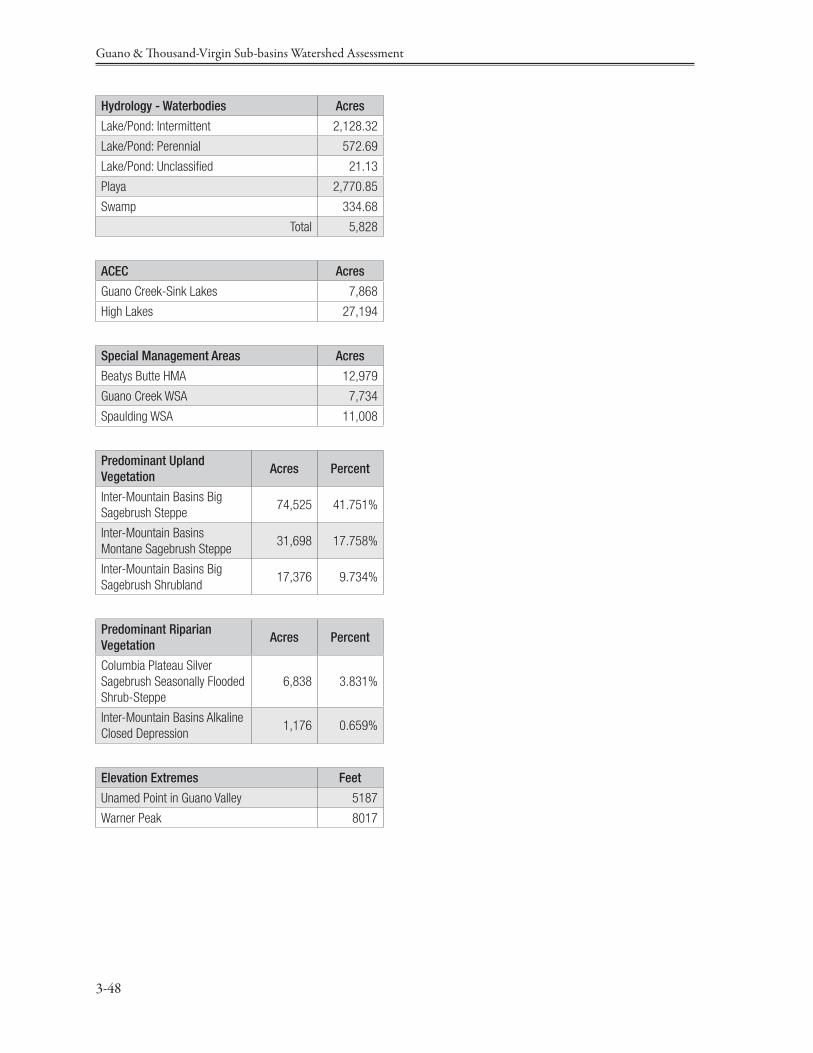
Guano & Thousand-Virgin Sub-basins Watershed Assessment
Hydrology - Waterbodies Acres
Lake/Pond: Intermittent 2,128.32
Lake/Pond: Perennial 572.69
Lake/Pond: Unclassified 21.13
Playa 2,770.85
Swamp 334.68
Total 5,828
ACEC Acres
Guano Creek-Sink Lakes 7,868
High Lakes 27,194
Special Management Areas Acres
Beatys Butte HMA 12,979
Guano Creek WSA 7,734
Spaulding WSA 11,008
Predominant Upland Vegetation
Acres Percent
Inter-Mountain Basins Big Sagebrush Steppe
74,525 41.751%
Inter-Mountain Basins Montane Sagebrush Steppe
31,698 17.758%
Inter-Mountain Basins Big Sagebrush Shrubland
17,376 9.734%
Predominant Riparian Vegetation
Acres Percent
Columbia Plateau Silver Sagebrush Seasonally Flooded Shrub-Steppe
6,838 3.831%
Inter-Mountain Basins Alkaline Closed Depression
1,176 0.659%
Elevation Extremes Feet
Unamed Point in Guano Valley 5187
Warner Peak 8017
3-49
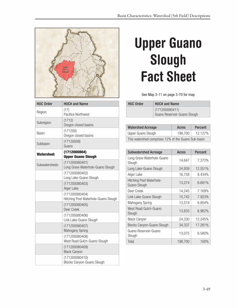
Basin Characteristics: Watershed (5th Field) Descriptions
Upper Guano Slough
Fact Sheet
HUC Order HUC# and Name
Region:(17) Pacifice Northwest
Subregion:(1712) Oregon closed basins
Basin:(171200) Oregon closed basins
Subbasin:(17120008) Guano
Watershed: (1712000804) Upper Guano Slough
Subwatersheds:(171200080401) Long Grave Waterhole-Guano Slough
(171200080402) Long Lake-Guano Slough
(171200080403) Alger Lake
(171200080404) Hitching Post Waterhole-Guano Slough
(171200080405) Deer Creek
(171200080406) Link Lake-Guano Slough
(171200080407) Mahogany Spring
(171200080408) West Road Gulch-Guano Slough
(171200080409) Black Canyon
(171200080410) Blocks Canyon-Guano Slough
HUC Order HUC# and Name
(171200080411) Guano Reservoir-Guano Slough
Watershed Acreage Acres Percent
Upper Guano Slough 198,700 12.127%
This watershed comprises 12% of the Guano Sub-basin
Subwatershed Acreage Acres Percent
Long Grave Waterhole-Guano Slough
14,647 7.372%
Long Lake-Guano Slough 24,939 12.551%
Alger Lake 16,758 8.434%
Hitching Post Waterhole-Guano Slough
13,274 6.681%
Deer Creek 14,245 7.169%
Link Lake-Guano Slough 15,742 7.923%
Mahogany Spring 13,519 6.804%
West Road Gulch-Guano Slough
13,833 6.962%
Black Canyon 24,330 12.245%
Blocks Canyon-Guano Slough 34,337 17.281%
Guano Reservoir-Guano Slough
13,075 6.580%
Total 198,700 100%
See Map 3-11 on page 3-70 for map
3-50
Guano & Thousand-Virgin Sub-basins Watershed Assessment
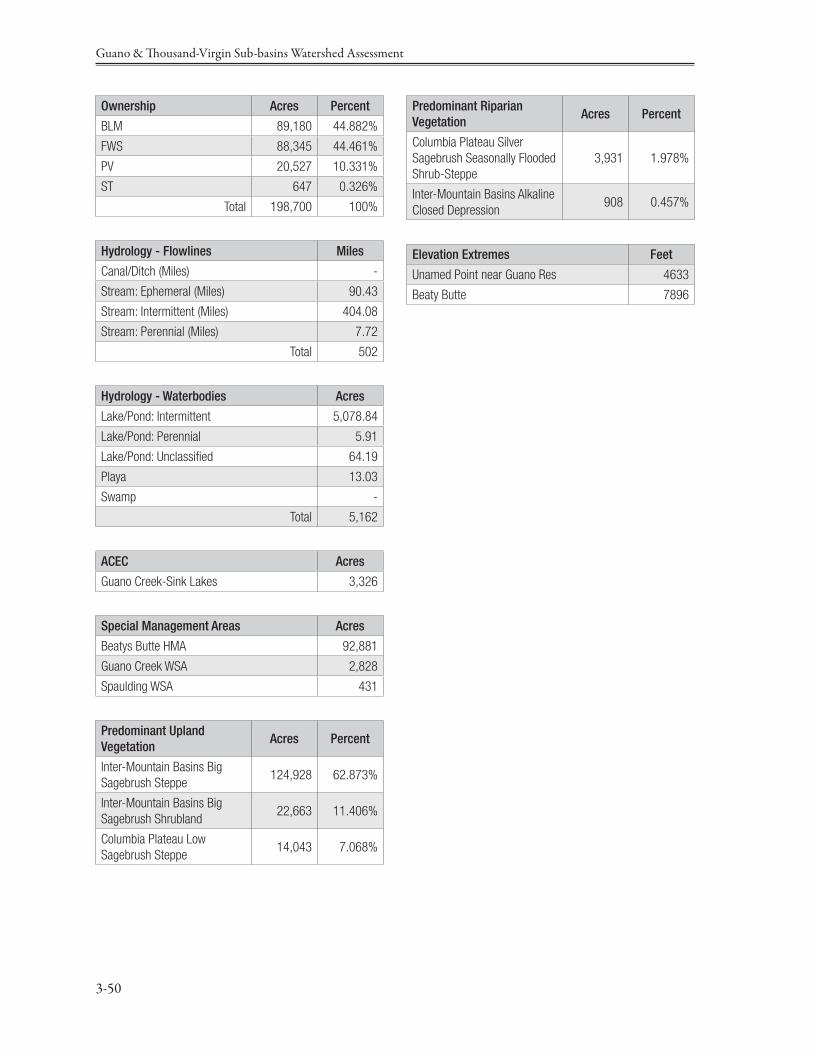
Ownership Acres Percent
BLM 89,180 44.882%
FWS 88,345 44.461%
PV 20,527 10.331%
ST 647 0.326%
Total 198,700 100%
Hydrology - Flowlines Miles
Canal/Ditch (Miles) -
Stream: Ephemeral (Miles) 90.43
Stream: Intermittent (Miles) 404.08
Stream: Perennial (Miles) 7.72
Total 502
Hydrology - Waterbodies Acres
Lake/Pond: Intermittent 5,078.84
Lake/Pond: Perennial 5.91
Lake/Pond: Unclassified 64.19
Playa 13.03
Swamp -
Total 5,162
ACEC Acres
Guano Creek-Sink Lakes 3,326
Special Management Areas Acres
Beatys Butte HMA 92,881
Guano Creek WSA 2,828
Spaulding WSA 431
Predominant Upland Vegetation
Acres Percent
Inter-Mountain Basins Big Sagebrush Steppe
124,928 62.873%
Inter-Mountain Basins Big Sagebrush Shrubland
22,663 11.406%
Columbia Plateau Low Sagebrush Steppe
14,043 7.068%
Predominant Riparian Vegetation
Acres Percent
Columbia Plateau Silver Sagebrush Seasonally Flooded Shrub-Steppe
3,931 1.978%
Inter-Mountain Basins Alkaline Closed Depression
908 0.457%
Elevation Extremes Feet
Unamed Point near Guano Res 4633
Beaty Butte 7896
3-51
Basin Characteristics: Watershed (5th Field) Descriptions
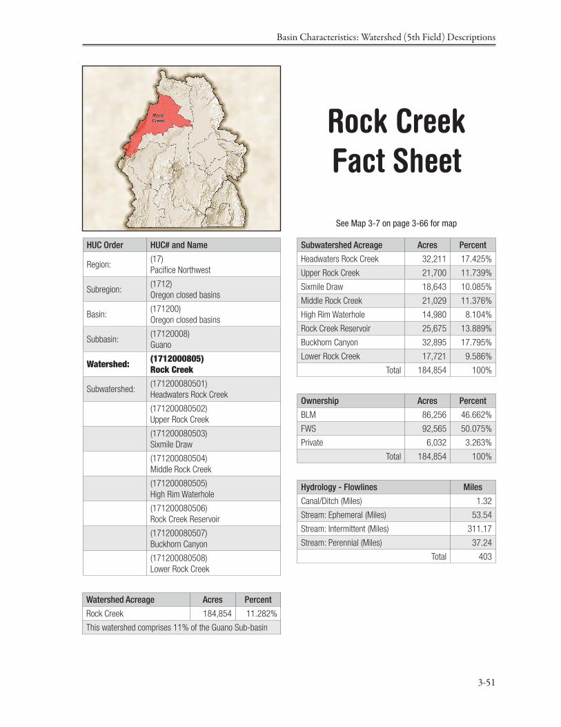
HUC Order HUC# and Name
Region:(17) Pacifice Northwest
Subregion:(1712) Oregon closed basins
Basin:(171200) Oregon closed basins
Subbasin:(17120008) Guano
Watershed: (1712000805) Rock Creek
Subwatershed:(171200080501) Headwaters Rock Creek
(171200080502) Upper Rock Creek
(171200080503) Sixmile Draw
(171200080504) Middle Rock Creek
(171200080505) High Rim Waterhole
(171200080506) Rock Creek Reservoir
(171200080507) Buckhorn Canyon
(171200080508) Lower Rock Creek
Watershed Acreage Acres Percent
Rock Creek 184,854 11.282%
This watershed comprises 11% of the Guano Sub-basin
Subwatershed Acreage Acres Percent
Headwaters Rock Creek 32,211 17.425%
Upper Rock Creek 21,700 11.739%
Sixmile Draw 18,643 10.085%
Middle Rock Creek 21,029 11.376%
High Rim Waterhole 14,980 8.104%
Rock Creek Reservoir 25,675 13.889%
Buckhorn Canyon 32,895 17.795%
Lower Rock Creek 17,721 9.586%
Total 184,854 100%
Ownership Acres Percent
BLM 86,256 46.662%
FWS 92,565 50.075%
Private 6,032 3.263%
Total 184,854 100%
Hydrology - Flowlines Miles
Canal/Ditch (Miles) 1.32
Stream: Ephemeral (Miles) 53.54
Stream: Intermittent (Miles) 311.17
Stream: Perennial (Miles) 37.24
Total 403
Rock Creek Fact Sheet
See Map 3-7 on page 3-66 for map
3-52
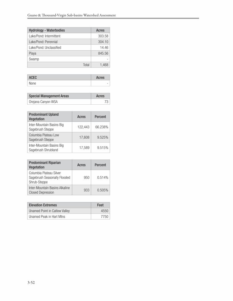
Guano & Thousand-Virgin Sub-basins Watershed Assessment
Hydrology - Waterbodies Acres
Lake/Pond: Intermittent 303.58
Lake/Pond: Perennial 304.10
Lake/Pond: Unclassified 14.46
Playa 845.56
Swamp -
Total 1,468
ACEC Acres
None -
Special Management Areas Acres
Orejana Canyon WSA 73
Predominant Upland Vegetation
Acres Percent
Inter-Mountain Basins Big Sagebrush Steppe
122,443 66.238%
Columbia Plateau Low Sagebrush Steppe
17,608 9.525%
Inter-Mountain Basins Big Sagebrush Shrubland
17,589 9.515%
Predominant Riparian Vegetation
Acres Percent
Columbia Plateau Silver Sagebrush Seasonally Flooded Shrub-Steppe
950 0.514%
Inter-Mountain Basins Alkaline Closed Depression
933 0.505%
Elevation Extremes Feet
Unamed Point in Catlow Valley 4550
Unamed Peak in Hart Mtns 7750
3-53
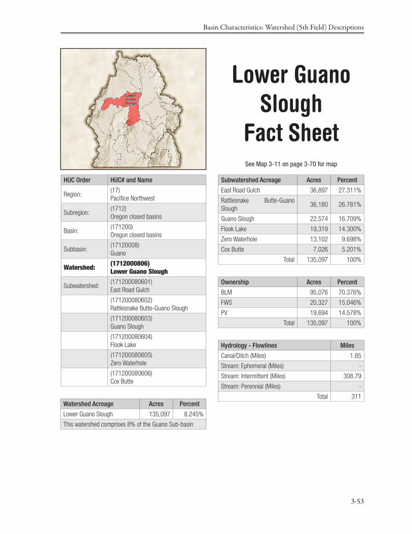
Basin Characteristics: Watershed (5th Field) Descriptions
HUC Order HUC# and Name
Region:(17) Pacifice Northwest
Subregion:(1712) Oregon closed basins
Basin:(171200) Oregon closed basins
Subbasin:(17120008) Guano
Watershed: (1712000806) Lower Guano Slough
Subwatershed:(171200080601) East Road Gulch
(171200080602) Rattlesnake Butte-Guano Slough
(171200080603) Guano Slough
(171200080604) Flook Lake
(171200080605) Zero Waterhole
(171200080606) Cox Butte
Watershed Acreage Acres Percent
Lower Guano Slough 135,097 8.245%
This watershed comprises 8% of the Guano Sub-basin
Subwatershed Acreage Acres Percent
East Road Gulch 36,897 27.311%
Rattlesnake Butte-Guano Slough
36,180 26.781%
Guano Slough 22,574 16.709%
Flook Lake 19,319 14.300%
Zero Waterhole 13,102 9.698%
Cox Butte 7,026 5.201%
Total 135,097 100%
Ownership Acres Percent
BLM 95,076 70.376%
FWS 20,327 15.046%
PV 19,694 14.578%
Total 135,097 100%
Hydrology - Flowlines Miles
Canal/Ditch (Miles) 1.85
Stream: Ephemeral (Miles) -
Stream: Intermittent (Miles) 308.79
Stream: Perennial (Miles) -
Total 311
Lower Guano Slough
Fact SheetSee Map 3-11 on page 3-70 for map
3-54
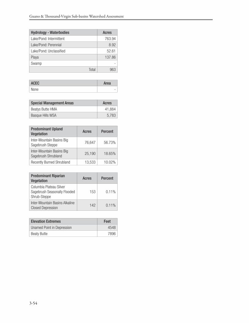
Guano & Thousand-Virgin Sub-basins Watershed Assessment
Hydrology - Waterbodies Acres
Lake/Pond: Intermittent 763.94
Lake/Pond: Perennial 8.92
Lake/Pond: Unclassified 52.61
Playa 137.86
Swamp -
Total 963
ACEC Area
None -
Special Management Areas Acres
Beatys Butte HMA 41,884
Basque Hills WSA 5,783
Predominant Upland Vegetation
Acres Percent
Inter-Mountain Basins Big Sagebrush Steppe
76,647 56.73%
Inter-Mountain Basins Big Sagebrush Shrubland
25,190 18.65%
Recently Burned Shrubland 13,533 10.02%
Predominant Riparian Vegetation
Acres Percent
Columbia Plateau Silver Sagebrush Seasonally Flooded Shrub-Steppe
153 0.11%
Inter-Mountain Basins Alkaline Closed Depression
142 0.11%
Elevation Extremes Feet
Unamed Point in Depression 4548
Beaty Butte 7896
3-55
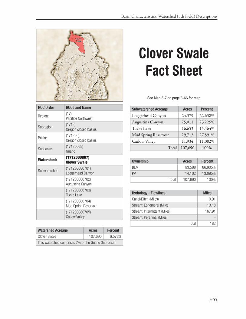
Basin Characteristics: Watershed (5th Field) Descriptions
HUC Order HUC# and Name
Region:(17) Pacifice Northwest
Subregion:(1712) Oregon closed basins
Basin:(171200) Oregon closed basins
Subbasin:(17120008) Guano
Watershed: (1712000807) Clover Swale
Subwatershed:(171200080701) Loggerhead Canyon
(171200080702) Augustina Canyon
(171200080703) Tucke Lake
(171200080704) Mud Spring Reservoir
(171200080705) Catlow Valley
Watershed Acreage Acres Percent
Clover Swale 107,690 6.572%
This watershed comprises 7% of the Guano Sub-basin
Subwatershed Acreage Acres Percent
Loggerhead Canyon 24,379 22.638%Augustina Canyon 25,011 23.225%Tucke Lake 16,653 15.464%Mud Spring Reservoir 29,713 27.591%Catlow Valley 11,934 11.082%
Total 107,690 100%
Ownership Acres Percent
BLM 93,588 86.905%
PV 14,102 13.095%
Total 107,690 100%
Hydrology - Flowlines Miles
Canal/Ditch (Miles) 0.91
Stream: Ephemeral (Miles) 13.18
Stream: Intermittent (Miles) 167.91
Stream: Perennial (Miles) -
Total 182
Clover Swale Fact Sheet
See Map 3-7 on page 3-66 for map
3-56
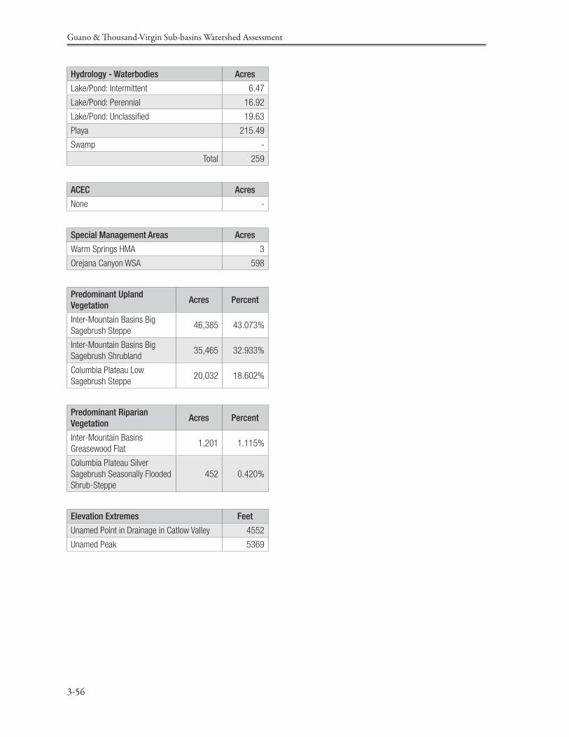
Guano & Thousand-Virgin Sub-basins Watershed Assessment
Hydrology - Waterbodies Acres
Lake/Pond: Intermittent 6.47
Lake/Pond: Perennial 16.92
Lake/Pond: Unclassified 19.63
Playa 215.49
Swamp -
Total 259
ACEC Acres
None -
Special Management Areas Acres
Warm Springs HMA 3
Orejana Canyon WSA 598
Predominant Upland Vegetation
Acres Percent
Inter-Mountain Basins Big Sagebrush Steppe
46,385 43.073%
Inter-Mountain Basins Big Sagebrush Shrubland
35,465 32.933%
Columbia Plateau Low Sagebrush Steppe
20,032 18.602%
Predominant Riparian Vegetation
Acres Percent
Inter-Mountain Basins Greasewood Flat
1,201 1.115%
Columbia Plateau Silver Sagebrush Seasonally Flooded Shrub-Steppe
452 0.420%
Elevation Extremes Feet
Unamed Point in Drainage in Catlow Valley 4552
Unamed Peak 5369