Embed Size (px)
Citation preview
Wildlife Data Standardization and Sharing: Environmental Data Transparency for New York State Offshore Wind EnergyFinal Report | Report Number 21-11 | May 2021

NYSERDA’s Promise to New Yorkers: NYSERDA provides resources, expertise, and objective information so New Yorkers can make confident, informed energy decisions.
Our Vision:New York is a global climate leader building a healthier future with thriving communities; homes and
businesses powered by clean energy; and economic opportunities accessible to all New Yorkers.
Our Mission:Advance clean energy innovation and investments to combat climate change, improving the health,
resiliency, and prosperity of New Yorkers and delivering benefits equitably to all.
Wildlife Data Standardization and Sharing: Environmental Data Transparency for New York State
Offshore Wind Energy Final Report
Prepared for:
New York State Energy Research and Development Authority
Albany, NY
Kate McClellan Press Project Manager
Prepared by:
Biodiversity Research Institute
Portland, ME
Edward Jenkins Kate Williams
Project Managers
NYSERDA Report 21-11 NYSERDA Contract 118972 May 2021 BRI Report No. 2020-21
ii
Notice This report was prepared by Biodiversity Research Institute (BRI) in the course of performing work
contracted for and sponsored by the New York State Energy Research and Development Authority
(hereafter “NYSERDA”). The opinions expressed in this report do not necessarily reflect those of
NYSERDA or the State of New York, and reference to any specific product, service, process, or
method does not constitute an implied or expressed recommendation or endorsement of it. Further,
NYSERDA, the State of New York, and the contractor make no warranties or representations,
expressed or implied, as to the fitness for particular purpose or merchantability of any product,
apparatus, or service, or the usefulness, completeness, or accuracy of any processes, methods, or
other information contained, described, disclosed, or referred to in this report. NYSERDA, the State
of New York, and the contractor make no representation that the use of any product, apparatus, process,
method, or other information will not infringe privately owned rights and will assume no liability for
any loss, injury, or damage resulting from, or occurring in connection with, the use of information
contained, described, disclosed, or referred to in this report.
NYSERDA makes every effort to provide accurate information about copyright owners and related
matters in the reports we publish. Contractors are responsible for determining and satisfying copyright
or other use restrictions regarding the content of reports that they write, in compliance with NYSERDA’s
policies and federal law. If you are the copyright owner and believe a NYSERDA report has not properly
attributed your work to you or has used it without permission, please email [email protected]
Information contained in this document, such as web page addresses, are current at the time
of publication.
Preferred Citation New York State Energy and Research Development Authority (NYSERDA). 2021. “Wildlife Data
Standardization and Sharing: Environmental Data Transparency for New York State Offshore Wind Energy.” NYSERDA Report 21-11. Prepared by E Jenkins and K Williams, Biodiversity Research Institute, Portland ME. nyserda.ny.gov/publications
iii
BRI Acknowledgements and Disclaimer The report authors would like to thank NYSERDA project managers Kate McClellan Press and Gregory
Lampman for their input and support on the development of this report. We would also like to thank the
many external reviewers and database managers who helped strengthen and clarify an earlier draft of
this report.
The information synthesized in this report came from a variety of sources; errors or areas of uncertainty
around specific database characteristics or processes may remain despite the authors’ best efforts.
Additionally, database capabilities are in some cases changing rapidly. Readers should plan to confirm
the capabilities or limitations of specific databases of interest. If a reader has specific feedback on the
information in this report, the authors ask that this input be emailed to [email protected] for
inclusion in a future update.
Table of Contents Notice .........................................................................................................................................ii Preferred Citation ......................................................................................................................ii BRI Acknowledgements and Disclaimer ................................................................................iii Definitions .................................................................................................................................v
Acronyms and Abbreviations .................................................................................................vi Executive Summary ............................................................................................................ ES-1
1 Introduction ........................................................................................................................1
2 Methods ..............................................................................................................................2
3 Databases for Raw Data ....................................................................................................6 3.1 Summary of Recommended Databases for Raw Data .............................................................. 6 3.2 eBird ........................................................................................................................................ 9 3.3 Northwest Atlantic Seabird Catalog ........................................................................................ 10 3.4 OBIS-SEAMAP ...................................................................................................................... 11 3.5 Movebank .............................................................................................................................. 12 3.6 Motus Database ..................................................................................................................... 13 3.7 Seabird Tracking Database .................................................................................................... 14 3.8 North American Bat Monitoring Program (NABat) ................................................................... 15 3.9 Bat Acoustic Monitoring Portal (BatAMP) ................................................................................ 16
iv
3.10 NCEI Passive Acoustic Monitoring (PAM) Archive .................................................................. 17 3.11 North Atlantic Humpback Whale and Fin Whale Catalogs (NAHWC and NAFWC) .................. 18 3.12 North Atlantic Right Whale Consortium (NARWC) Databases ................................................. 19 3.13 Animal Telemetry Network Data Assembly Center (ATN DAC) ............................................... 20 3.14 Ocean Tracking Network ........................................................................................................ 22 3.15 National Database for Deep Sea Corals and Sponges ............................................................ 23
4 Databases for Derived Data Products ............................................................................24 4.1 Marine Cadastre ..................................................................................................................... 24 4.2 Mid-Atlantic Ocean Data Portal and Northeast Ocean Data Portal .......................................... 25 4.3 ..................................................................................................................................................... 26
5 Metadatabase for Offshore Wind Environmental Data ..................................................27
6 Real-Time Data Reporting ...............................................................................................28
7 Discussion ........................................................................................................................29 7.1 Recommended Databases ..................................................................................................... 29 7.2 Recommended Data Submission Practices ............................................................................ 30 7.3 Opportunities for Database Expansion and Development: Gaps in Relevant Repositories ....... 32 7.4 Ongoing Database Expansion Efforts ..................................................................................... 33 7.5 Data Centralization and Standardization ................................................................................. 35
8 References .......................................................................................................................37
Appendix A. Full List of Relevant Databases ...................................................................... A-1
Appendix B. Other Databases .............................................................................................. B-1
Endnotes ............................................................................................................................ EN-1
v
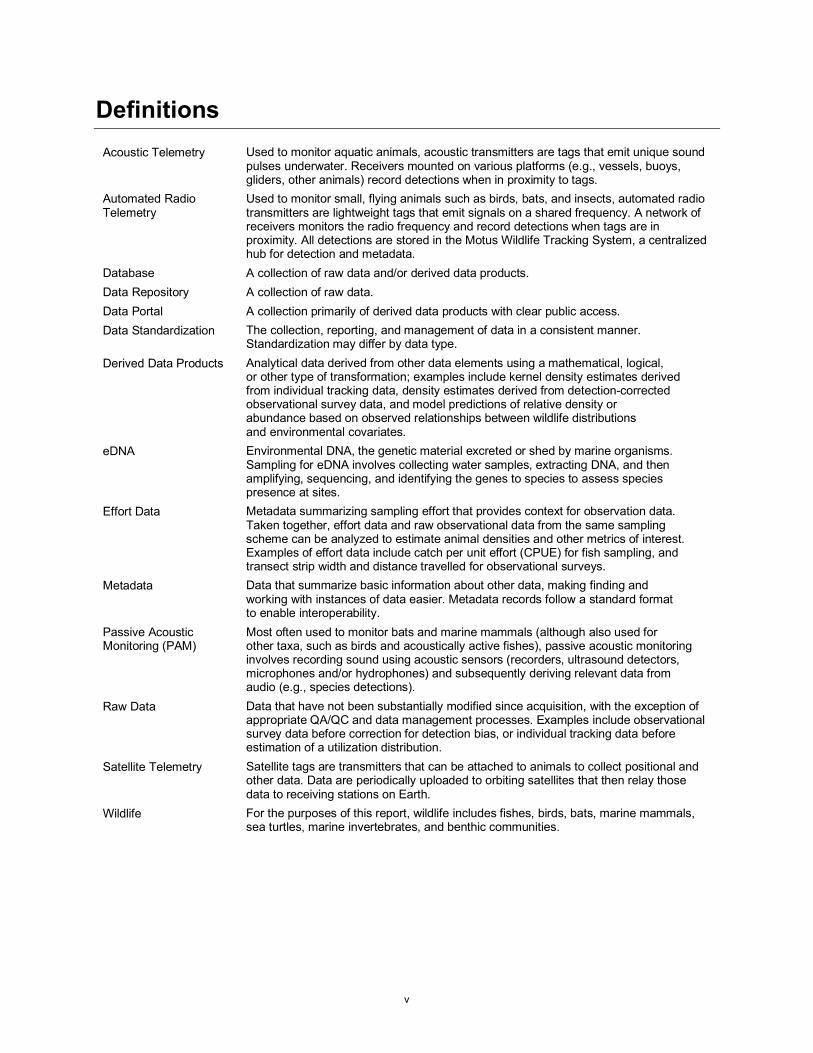
Definitions Acoustic Telemetry Used to monitor aquatic animals, acoustic transmitters are tags that emit unique sound
pulses underwater. Receivers mounted on various platforms (e.g., vessels, buoys, gliders, other animals) record detections when in proximity to tags.
Automated Radio Telemetry
Used to monitor small, flying animals such as birds, bats, and insects, automated radio transmitters are lightweight tags that emit signals on a shared frequency. A network of receivers monitors the radio frequency and record detections when tags are in proximity. All detections are stored in the Motus Wildlife Tracking System, a centralized hub for detection and metadata.
Database A collection of raw data and/or derived data products. Data Repository A collection of raw data. Data Portal A collection primarily of derived data products with clear public access. Data Standardization The collection, reporting, and management of data in a consistent manner.
Standardization may differ by data type. Derived Data Products Analytical data derived from other data elements using a mathematical, logical,
or other type of transformation; examples include kernel density estimates derived from individual tracking data, density estimates derived from detection-corrected observational survey data, and model predictions of relative density or abundance based on observed relationships between wildlife distributions and environmental covariates.
eDNA Environmental DNA, the genetic material excreted or shed by marine organisms. Sampling for eDNA involves collecting water samples, extracting DNA, and then amplifying, sequencing, and identifying the genes to species to assess species presence at sites.
Effort Data Metadata summarizing sampling effort that provides context for observation data. Taken together, effort data and raw observational data from the same sampling scheme can be analyzed to estimate animal densities and other metrics of interest. Examples of effort data include catch per unit effort (CPUE) for fish sampling, and transect strip width and distance travelled for observational surveys.
Metadata Data that summarize basic information about other data, making finding and working with instances of data easier. Metadata records follow a standard format to enable interoperability.
Passive Acoustic Monitoring (PAM)
Most often used to monitor bats and marine mammals (although also used for other taxa, such as birds and acoustically active fishes), passive acoustic monitoring involves recording sound using acoustic sensors (recorders, ultrasound detectors, microphones and/or hydrophones) and subsequently deriving relevant data from audio (e.g., species detections).
Raw Data Data that have not been substantially modified since acquisition, with the exception of appropriate QA/QC and data management processes. Examples include observational survey data before correction for detection bias, or individual tracking data before estimation of a utilization distribution.
Satellite Telemetry Satellite tags are transmitters that can be attached to animals to collect positional and other data. Data are periodically uploaded to orbiting satellites that then relay those data to receiving stations on Earth.
Wildlife For the purposes of this report, wildlife includes fishes, birds, bats, marine mammals, sea turtles, marine invertebrates, and benthic communities.
vi
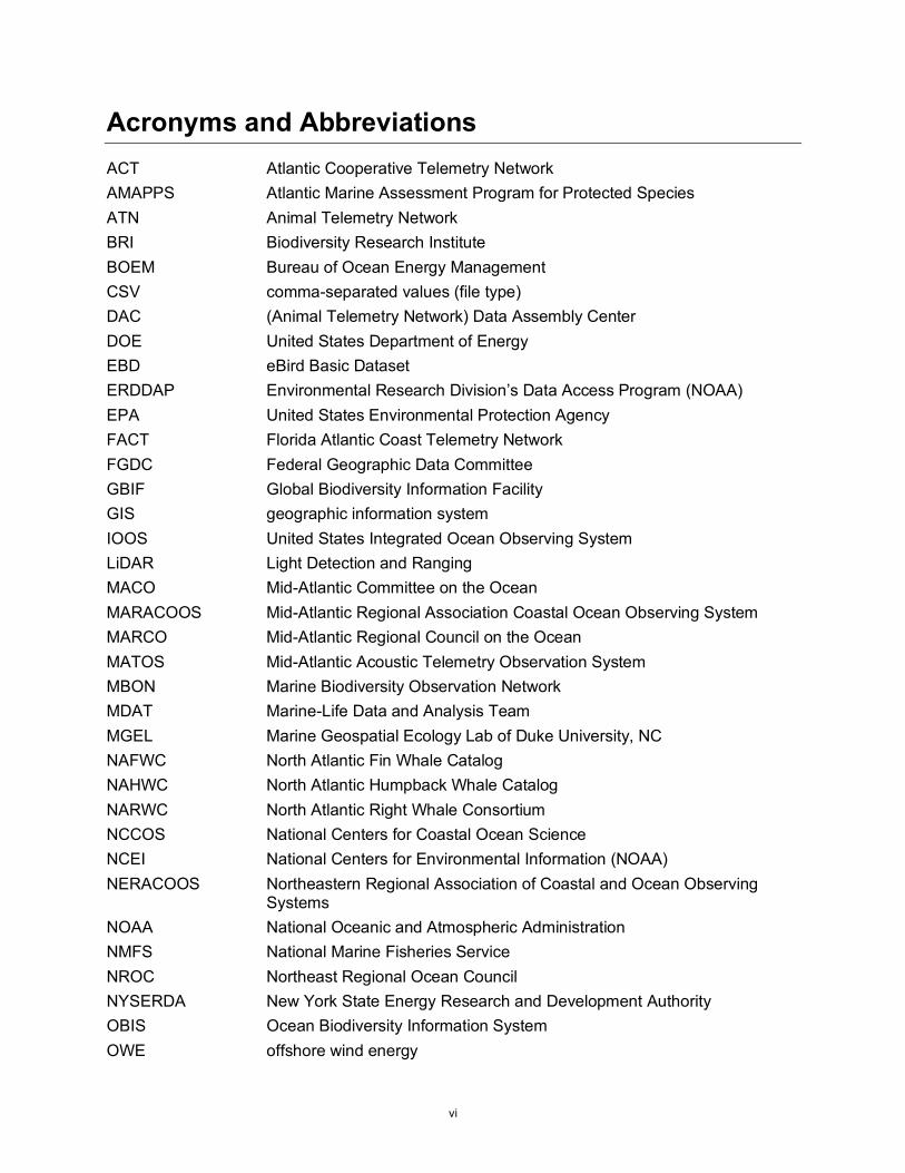
Acronyms and Abbreviations ACT Atlantic Cooperative Telemetry Network AMAPPS Atlantic Marine Assessment Program for Protected Species ATN Animal Telemetry Network BRI Biodiversity Research Institute BOEM Bureau of Ocean Energy Management CSV comma-separated values (file type) DAC (Animal Telemetry Network) Data Assembly Center DOE United States Department of Energy EBD eBird Basic Dataset ERDDAP Environmental Research Division’s Data Access Program (NOAA) EPA United States Environmental Protection Agency FACT Florida Atlantic Coast Telemetry Network FGDC Federal Geographic Data Committee GBIF Global Biodiversity Information Facility GIS geographic information system IOOS United States Integrated Ocean Observing System LiDAR Light Detection and Ranging MACO Mid-Atlantic Committee on the Ocean MARACOOS Mid-Atlantic Regional Association Coastal Ocean Observing System MARCO Mid-Atlantic Regional Council on the Ocean MATOS Mid-Atlantic Acoustic Telemetry Observation System MBON Marine Biodiversity Observation Network MDAT Marine-Life Data and Analysis Team MGEL Marine Geospatial Ecology Lab of Duke University, NC NAFWC North Atlantic Fin Whale Catalog NAHWC North Atlantic Humpback Whale Catalog NARWC North Atlantic Right Whale Consortium NCCOS National Centers for Coastal Ocean Science NCEI National Centers for Environmental Information (NOAA) NERACOOS Northeastern Regional Association of Coastal and Ocean Observing
Systems NOAA National Oceanic and Atmospheric Administration NMFS National Marine Fisheries Service NROC Northeast Regional Ocean Council NYSERDA New York State Energy Research and Development Authority OBIS Ocean Biodiversity Information System OWE offshore wind energy
vii
OTN Ocean Tracking Network PNNL Pacific Northwest National Laboratory PSO Protected Species Observer PTT Platform Transmitting Terminal QA/QC quality assurance/quality control RWSE Regional Wildlife Science Entity for Atlantic Offshore Wind SEAMAP Spatial Ecological Analysis of Megavertebrate Populations (OBIS node) SWOT State of the World’s Sea Turtles Project UNESCO United Nations Educational, Scientific and Cultural Organization USGS United States Geological Survey USFWS United States Fish and Wildlife Service VHF very high frequency
ES-1
Executive Summary Offshore wind energy developers selling power to the New York State are required to make
non-proprietary environmental data publicly available “as soon after collection [as] is practicable
for use by third parties in decision-making around adaptive management” (NYSERDA 2020). The
requirement is also intended to improve general understanding of wildlife populations and marine
ecosystem dynamics (NYSERDA 2019). This report is intended to facilitate transparency and sharing
of non-proprietary environmental data for offshore wind (OSW) energy development, including projects
selling power to the State, by reviewing key wildlife-focused databases to which data owners can submit
their raw data or derived data products. In order for a database to aid in achieving NYSERDA’s data
transparency goals for OSW developers, and stay within the wildlife-focused scope of this report, it
was considered that a database must at minimum (1) focus on wildlife (including fishes, birds, bats,
marine mammals, sea turtles, marine invertebrates, and benthic communities), (2) host data expected
to be collected by developers, (3) have geographic relevance, and (4) accept raw data produced by
other parties, and share these data publicly (either on demand or by request). For each general type
of wildlife data expected to be collected by developers and their consultants, this report first identifies
relevant databases that can receive and house such data using the four criteria listed above. From those,
a second set of more detailed criteria were used to identify a subset of databases most appropriate for
meeting the State’s data transparency goals.
A total of 15 databases are recommended as primary or secondary repositories for different types of raw
data generated by OSW developers and their contractors. Some, such as OBIS-SEAMAP and Movebank,
have widespread utility, as they accept multiple types of data for a range of taxa, but may not be the best
choice for some specific data types. Other recommended databases tend to be more specialized, including
those dedicated to taxa- or technology-specific animal tracking data (Motus Database, Seabird Tracking
Database, Animal Telemetry Network Data Assembly Center, Ocean Tracking Network); at-sea survey
data (the Northwest Atlantic Seabird Catalog); onshore bird survey data (eBird); bat survey data (NABat);
coral and sponge data (the National Database for Deep Sea Corals and Sponges); passive acoustic data
(BatAMP, NABat, NCEI Passive Monitoring Archive); and whale photo ID data (the North Atlantic
Fin Whale Catalog, North Atlantic Humpback Whale Catalog, and the North Atlantic Right Whale
Consortium Database). Key databases for derived data products, rather than raw data, that are relevant
to OSW development in the eastern United States include Marine Cadastre, Digital Coast, the
Mid-Atlantic Ocean Data Portal, and the Northeast Ocean Data Portal.
ES-2
Regardless of the database(s) chosen to host data, it is recommended that to meet New York State’s
data transparency objectives, offshore wind energy data contributors do the following:
• Follow all relevant guidelines and recommendations for the submission of wildlife data, such as those from the Bureau of Ocean Energy Management (BOEM), the National Marine Fisheries Service (NMFS), and regional science entities. As different states may have specific requirements regarding data collection, transparency, or housing, reaching out to relevant state agencies before data collection begins will also help ensure any obligations are met.
• Develop data sharing plans and communicate them to all relevant parties well ahead of time, as government agency recommendations (and database capabilities) may change over time.
• Consider effort data (where relevant) as essential information and prioritize effort data for submission alongside observations.
• Co-collect and report appropriate abiotic environmental data for interpretation of wildlife information as needed. Examples include water temperature data to assist with interpretation of aquatic passive acoustic monitoring, and data on sediment characteristics that can help understand benthic community structures. Such abiotic data were not the focus of this report, but best practice is to report any abiotic data necessary for interpretation alongside wildlife information.
• Devote resources to developing comprehensive metadata for all data types following Federal Geographic Data Committee (FGDC) metadata standards1 (or other standards as appropriate). Detailed standards exist for both spatial and non-spatial data types.
• Disseminate raw data to the most appropriate database(s) as soon as feasible following internal quality assurance and quality control (QA/QC), to maximize the data’s exposure and utility. NYSERDA specifies that such data sharing must occur “as soon after collection [as] is practicable” (NYSERDA 2020). Based on discussion with regulators, scientists, and other stakeholders, sharing data within two years is strongly recommended, although the feasibility of this timeline may depend on data type and individual project circumstances.
• Submit project metadata to the environmental metadata base in the Tethys Knowledge Base, so that interested parties can quickly identify what data have been collected at the project site and where they can access those data and additional information.
• Share derived data products (e.g., model outputs, summary maps) as well as raw data.
While most taxa and data type combinations discussed in this report have clear database options, there are
also some gaps. For example, benthos, zooplankton and fish data, Protected Species Observer (PSO) data,
and some other data types are poorly served by extant databases (either because relevant databases do not
exist, they do not accept private data, or do not permit public access to those data). Data collected by the
OSW industry that lack a clear “home” in an existing database should be housed and made available by
the data originator directly (for example, on a project website) until opportunities arise to submit those
data to other databases. Data originators are also encouraged to consider potential support for the
development of appropriate public databases.
ES-3
As the offshore wind energy industry continues to develop in the U.S., and increasing resources
are channeled into environmental monitoring, well-considered data collection, coordination, and
dissemination are becoming increasingly important. Focused efforts on the above fronts will make
the submitted data as useful and accessible as possible for future analyses, create future efficiencies,
and ensure decision-makers have the best information available to manage this growing industry.
1
1 Introduction There is a need to better understand the environmental impacts of offshore wind energy development
in the eastern United States and assess cumulative impacts across projects as they are built (Goodale and
Milman 2014, Goodale et al. 2019). As the industry grows and more developers collect data on the marine
environment, there is a unique opportunity to collate and standardize these data and make them available
for future site assessments, meta-analyses, or other research and decision-making. However, without data
sharing agreements, data collected at substantial effort and cost can become unrecoverable due to loss of
data or lack of contact information (Couture et al. 2018). As the central administrator of the New York
Offshore Wind Standard program, the New York State Energy Research and Development Authority
(NYSERDA) stipulates that offshore wind energy developers selling power to New York State must
make all non-proprietary environmental data collected during site assessment, development, operations,
and research available to the public, including data on “air quality and emissions, water quality, fish and
fish habitats, birds and bats, marine mammals and sea turtles, and benthic communities” (NYSERDA
2018, NYSERDA 2020). Developers are required to provide a Data Availability Plan to NYSERDA
within 90 days of contract execution which details “how site and environmental data will be made
available on an ongoing basis as soon after collection is practicable for use by third parties in decision-
making around adaptive management” (NYSERDA 2020). This requirement is intended to “reinforce
the transparency” of projects and has been deemed a crucial tool in assessing projects in real time, as
well as adding to the general understanding of marine ecosystem dynamics in the area (NYSERDA 2019).
The goal of this report is to facilitate transparency and sharing of non-proprietary environmental data
for OSW development, including projects selling power to New York State, by reviewing key databases
to which data owners can submit their raw data or derived data products. This report focuses specifically
on wildlife data. Items not discussed in the report are abiotic factors, such as air and water quality,
and co-collected covariate data, such as sediment grain size or organic carbon content. Such covariate
information can be important or even essential for interpretation of wildlife data but was not the focus
of this report. For each type of wildlife data expected to be collected by OSW developers and their
consultants, this report firstly identifies relevant databases that can receive and house such data, and
from those, identifies the databases most appropriate for meeting the State’s data transparency goals.
Developers should review the recommendations in this report before choosing where to submit their
data (NYSERDA 2020).
2
2 Methods The archiving of all relevant data in a single central facility, such as the United Kingdom’s Marine
Data Exchange,2 the European Union’s European Marine Observation and Data Network (EDMODnet),3
or California’s Offshore Wind Energy Gateway,4 is desirable in many ways, because it greatly facilitates
integrated data standards and sharing across disciplines. However, the creation and establishment of
such databases takes substantial time and resources. In the absence of a similar database for the east
coast of the United States, this report examines multiple existing and complementary databases
covering different taxonomic groups and data collection methods that are most likely to be relevant
to OSW developers as part of site assessment and pre- and post-construction monitoring on the east
coast of the U.S. (Figure 1). Relevant databases for the purposes of this report (as listed in appendix A),
are those that:
1. Include a focus on wildlife (including fishes, birds, bats, marine mammals, sea turtles, marine invertebrates, and benthic communities).
2. Host data that could be expected to be collected by OSW developers and their consultants. 3. Have geographic relevance (e.g., geographic scope of the database includes part or all the
coastal and offshore areas from Massachusetts to North Carolina). 4. Accept raw data submitted by private parties and make it publicly accessible or available
upon request.
A list of examined databases that do not meet these basic relevance criteria are included in appendix B.
Following identification of relevant databases (appendix A), the relative utility of each database as
a repository for OSW data was reviewed using the following set of detailed and somewhat
subjective criteria:
1. Database hosts data that OSW developers are expected to collect in substantial amounts and/or to make a worthwhile contribution.
2. Database is user-friendly and allows submitted data to be made available to users within a reasonable time period.
3. Database has a public interface allowing users to browse stored data. 4. Database is a widely accepted option for the taxon and/or data collection method in question. 5. Data undergo rigorous QA/QC before being made available. 6. Database houses and serves up effort data appropriate to the collection method (i.e., necessary
contextual data such as catch per unit effort for fish sampling or the survey track for observational surveys), where applicable.
7. Database houses and serves up metadata.
3
8. Database has either long-term support, or an established position and good reputation over a period of a decade or more, suggesting that the database will remain stable and accessible to users for the foreseeable future.
Databases were informally scored based on these criteria. Those that best met the criteria are reviewed
below and summarized in Table 1. In cases where several recommended databases could be the repository
for a given taxon and type of data, they are classified as a “primary” database (judged to be the best
database option available) and a “secondary” database that met the criteria but was not the best option,
often because another recommended database was the de facto standard for housing that particular type
of data. Secondary databases are listed in case developers are able to submit data to both databases (ideal)
or as alternatives for situations where, for various reasons, the primary database may not be a feasible
option. Some taxa and/or data types are not currently well served by any relevant databases and are
reviewed in the discussion.
In line with the above criteria, this report is primarily focused on repositories for raw data, rather
than derived analytical products such as modelled abundance or occupancy predictions. There are
advantages to using derived data products for purposes such as siting OSW projects and conducting
initial assessments of risk (e.g., exposure), as they can aid in swift interpretation, address biases in
different data collection methods, and help users make the most of the available data set(s). However,
availability of raw data ensures long-term relevance for data set(s), particularly in the face of advances
in analysis techniques and interpretation, allowing for reanalysis of existing data at a future date. It
also enables analytical approaches that require compilation of data from multiple sites. Comprehensive
metadata gives important information about the associated raw data, minimizing the risk of misuse.
This report addresses data collected from all project components, including terrestrial, nearshore,
and offshore areas, and a range of data types, including live sampling data (the lethal collection of
animals), observational survey data (visual or camera-based surveys from a range of platforms), passive
acoustic data (above- and below-water acoustic recording of animal sounds), individual identification
data (identifying individual animals using photographs), and tracking data (monitoring the position
and/or movement of individual animals). Some data types that OSW developers and their consultants
may collect (e.g., live sampling of fishes) are not covered in detail in this report due to a lack of relevant
databases to house those data types. Databases for some of these other data types are listed in appendix B.
Data types for which there are currently no adequate databases are considered in the discussion section
of this report.
4
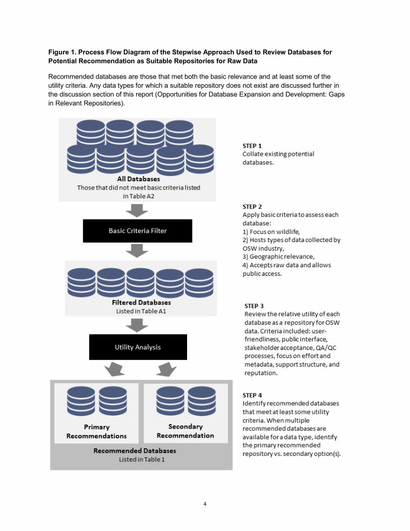
Figure 1. Process Flow Diagram of the Stepwise Approach Used to Review Databases for Potential Recommendation as Suitable Repositories for Raw Data
Recommended databases are those that met both the basic relevance and at least some of the utility criteria. Any data types for which a suitable repository does not exist are discussed further in the discussion section of this report (Opportunities for Database Expansion and Development: Gaps in Relevant Repositories).
5
The following summaries may reference data archives used to host data (“databases” or “repositories”),
as well as data distribution programs used to serve data from archives to the user. For example, the
National Oceanic and Atmospheric Administration (NOAA) archives its environmental data at the
National Centers for Environmental Information (NCEI),5 and distributes them using various access
platforms like the flexible open source Environmental Research Division’s Data Access Program
(ERDDAP) and dedicated data portals for specific data types such as those hosted by the Integrated
Ocean Observing System (IOOS), Northeastern Regional Association of Coastal Ocean Observing
System (NERACOOS), and Mid-Atlantic Regional Association Coastal Ocean Observing System
(MARACOOS). This report focuses on data archives used to host data, not the data distribution
platforms, although in some cases relevant platforms are mentioned where associated with data archives.

6
3 Databases for Raw Data 3.1 Summary of Recommended Databases for Raw Data
Databases that are valuable potential repositories of raw environmental data for OSW are reviewed in
the sections below. Table 1 provides a quick reference guide of the most relevant database(s) for key
data types. Archiving data to multiple databases helps guarantee data security as well as increasing the
accessibility of those data, and therefore for some taxa and data combinations a “secondary” optional
repository is recommended. Additional relevant databases that may be less desirable as OSW data
repositories, given criteria listed above, are included in appendix A.
7
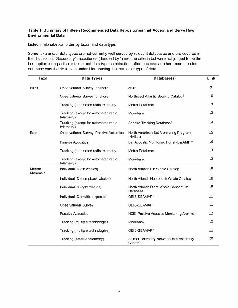
Table 1. Summary of Fifteen Recommended Data Repositories that Accept and Serve Raw Environmental Data
Listed in alphabetical order by taxon and data type.
Some taxa and/or data types are not currently well served by relevant databases and are covered in the discussion. “Secondary” repositories (denoted by *) met the criteria but were not judged to be the best option for a particular taxon and data type combination, often because another recommended database was the de facto standard for housing that particular type of data.
Taxa Data Types Database(s) Link
Birds Observational Survey (onshore) eBird 9
Observational Survey (offshore) Northwest Atlantic Seabird Catalog6 10
Tracking (automated radio telemetry) Motus Database 13
Tracking (except for automated radio telemetry)
Movebank 12
Tracking (except for automated radio telemetry)
Seabird Tracking Database* 14
Bats Observational Survey, Passive Acoustics North American Bat Monitoring Program (NABat)
15
Passive Acoustics Bat Acoustic Monitoring Portal (BatAMP)* 16
Tracking (automated radio telemetry) Motus Database 13
Tracking (except for automated radio telemetry)
Movebank 12
Marine Mammals
Individual ID (fin whales) North Atlantic Fin Whale Catalog 18
Individual ID (humpback whales) North Atlantic Humpback Whale Catalog 18
Individual ID (right whales) North Atlantic Right Whale Consortium Database
19
Individual ID (multiple species) OBIS-SEAMAP* 11
Observational Survey OBIS-SEAMAP 11
Passive Acoustics NCEI Passive Acoustic Monitoring Archive 17
Tracking (multiple technologies) Movebank 12
Tracking (multiple technologies) OBIS-SEAMAP* 11
Tracking (satellite telemetry) Animal Telemetry Network Data Assembly Center*
20
8
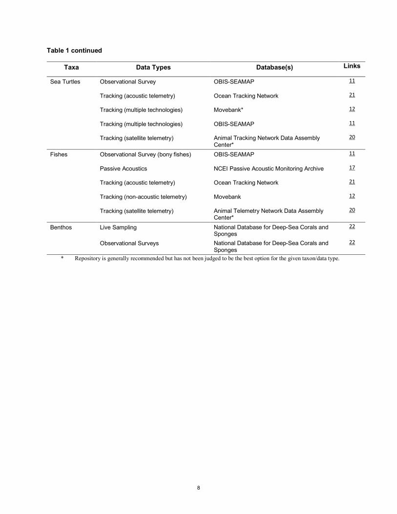
Table 1 continued
Taxa Data Types Database(s) Links
Sea Turtles Observational Survey OBIS-SEAMAP 11
Tracking (acoustic telemetry) Ocean Tracking Network 21
Tracking (multiple technologies) Movebank* 12
Tracking (multiple technologies) OBIS-SEAMAP 11
Tracking (satellite telemetry) Animal Tracking Network Data Assembly Center*
20
Fishes Observational Survey (bony fishes) OBIS-SEAMAP 11
Passive Acoustics NCEI Passive Acoustic Monitoring Archive 17
Tracking (acoustic telemetry) Ocean Tracking Network 21
Tracking (non-acoustic telemetry) Movebank 12
Tracking (satellite telemetry) Animal Telemetry Network Data Assembly Center*
20
Benthos Live Sampling National Database for Deep-Sea Corals and Sponges
22
Observational Surveys National Database for Deep-Sea Corals and Sponges
22
* Repository is generally recommended but has not been judged to be the best option for the given taxon/data type.
9
3.2 eBird
Manager: The Cornell Lab of Ornithology Contact: Marshall Iliff, [email protected] URL: https://ebird.org/home
Description: Launched in 2002 by the Cornell Lab of Ornithology and the National Audubon Society,
eBird is the world’s largest bird-related citizen science project, with more than half a billion observations
submitted by almost 600,000 observers. Visual bird observation data are submitted in the form of
checklists that include number of species and individuals detected while stationary or travelling. Ancillary
data may be added including information on age, sex, and breeding activity. Checklists are submitted
from around the globe and used to monitor species population trends (Walker and Taylor 2017) and
distributions (Johnston et al. 2019), and to inform conservation efforts (Young et al. 2019).
eBird users have access to specific data collection protocols, which are selected by observers as options
within the application. These include the pelagic protocol for offshore surveys, which requires the user
be greater than two miles from shore and to separate the list into 60-minute segments while recording
distance travelled; the nocturnal flight call protocol for recording migrating songbirds, which must be
conducted at night and requires the user to be stationary; and the International Shorebird Survey (ISS)
protocol for repeated shorebird surveys at designated sites.
eBird data are typically opportunistic, as the association of quantitative measures of survey effort is not
enforced. However, the submitter can confirm that they are reporting all birds detected (either aurally or
visually), meaning inferred non-detections are zero-filled, and the mobile application includes a tracking
function which uses GPS to associate accurate location data. Submitted observation data are publicly
available unless tagged as hidden, in which case they are not included in the eBird Basic Dataset (EBD)
and other outputs. The EBD contains all raw observations and metadata and is available as an Excel
spreadsheet via request. Submitted data are immediately viewable and available for download from
the website, while the EBD is updated monthly. The package “auk” for the statistical software R
(R Core Team 2019) is a helpful tool for managing these data. Alternatively, the website allows
searching by species, time, or location, and can easily produce maps and figures.
Application to OSW Development: eBird is a good option for recording and archiving onshore
bird survey data so long as the protocol being used requires effort data. Offshore data, even if recorded
using eBird rather than a dedicated application such as SeaScribe,7 should be submitted to the Northwest
Atlantic Seabird Catalog (see below).
10
3.3 Northwest Atlantic Seabird Catalog
Manager: National Oceanic and Atmospheric Administration (NOAA) National Centers for Coastal Ocean Science (NCCOS) Contact: Arliss Winship, [email protected] URL: No website as of late 2020; data are available via direct request
Description: The Northwest Atlantic Seabird Catalog was developed at the U.S. Geological Survey
(USGS) in 2005 with funding support from United States Fish and Wildlife Service (USFWS) and BOEM
and has been managed by NOAA NCCOS since 2019. The Catalog includes upwards of 180 data sets
of more than 700,000 observation records from 1938–2017 (O’Connell et al. 2009, Winship et al. 2018).
It contains most of the coastal and offshore visual seabird survey data from the east coast of the U.S.,
including boat-based, visual aerial, digital aerial, and land-based survey data from sources including the
Atlantic Marine Assessment Program for Protected Species (AMAPPS), USFWS, and Christmas Bird
Counts. Data sets also include observed marine mammals, fishes, sea turtles, and other wildlife. Data
products, including modelled long-term relative densities of seabirds at sea (140 species) developed
using the database as well as data from Canada, are available online at the Northeast Ocean Data Portal8
(Winship et al. 2018). While well known among seabird researchers and managers, the database does
not currently have an online interface, so data must be directly requested via email.
Users submitting data must request and follow a series of guidelines which allow for submission using
most file types and require associated metadata (effort data are strongly recommended). Database
managers then manually check data for outliers, incorrect codes, and other incorrect data (e.g., dates,
times, coordinates). Both the data submission guidelines and quality control processes are intended to
be updated in the near future (A. Winship, pers. comm., Jun. 5, 2020).
Application to OSW Development: The Seabird Catalog is the primary repository for offshore bird
survey data for the east coast of the U.S. and is used by BOEM for decision-making relating to OSW
siting (BOEM 2020). Full at-sea survey data sets (including effort data and observations of all taxa,
not just seabirds) should be submitted to the Catalog. OBIS-SEAMAP is a secondary repository for
offshore bird survey data (below). Onshore bird survey data should be shared with eBird (see above).
11
3.4 OBIS-SEAMAP
Manager: OBIS, Marine Geospatial Ecology Lab (MGEL) of Duke University Contact: Ei Fujioka, [email protected] URL: http://seamap.env.duke.edu/
Description: Ocean Biogeographic Information System—Spatial Ecological Analysis of Megavertebrate
Populations (OBIS-SEAMAP) is a temporally and spatially referenced database with a global focus that
houses more than 1,250 data sets and more than 6.4 million records of marine mammals, sea turtles, birds,
and some fishes (typically large bony fish such as sharks). Data are collected primarily from observational
surveys, as well as animal telemetry, acoustic monitoring, and photo identification (Fujioka et al. 2014,
Grassle 2000). Since 2012, OBIS-SEAMAP has hosted the biogeography database9 for The State of the
World’s Sea Turtles (SWOT) project,10 including telemetry and nesting location data.
The publicly accessible interface has tools for data exploration and visualization, including representation
of oceanographic variables. OBIS-SEAMAP is a thematic node of OBIS, which is in turn a project of
the International Oceanographic Data and Information Exchange (IODE) program under the United
Nations Educational, Scientific, and Cultural Organization (UNESCO). As such, data uploaded to
OBIS-SEAMAP may be automatically shared in a limited form with OBIS and the Global
Biodiversity Information Facility (GBIF; both are included in appendix A2).
OBIS-SEAMAP is easy to use, data contribution guidelines are simple to follow, and the inclusion
of effort data are emphasized (e.g., GPS locations which are used by the system to create tracklines).
Users can submit data to OBIS-SEAMAP in virtually any format (e.g., text files, Excel spreadsheets,
and ESRI shapefiles), but must include species, location, and date information. Specific data standards
for SWOT are available via the SWOT website. Data go through a scripted data registration process
where a quality check is applied before review by the contributor prior to being made freely available
for download via a web interface. While some sub-projects within OBIS-SEAMAP are funded, such
as the photo ID application, there is no funding for the overall maintenance of OBIS-SEAMAP, and
the database is managed on a voluntary basis by the Duke University MGEL.
Application to OSW Development: BOEM site characterization survey guidelines suggest that
survey data for marine mammals and sea turtles be shared with OBIS-SEAMAP (BOEM 2019). Sea
turtle satellite telemetry data should be submitted to OBIS-SEAMAP through the SWOT project
website (see above).
12
OBIS-SEAMAP is also a good database option for submitting survey data of large bony fishes and
seabirds, although the Northwest Atlantic Seabird Catalog should be prioritized before OBIS-SEAMAP
for submission of offshore bird survey data (see above). Submission of tracking data and photo ID data
should generally focus first on databases specific to these data types (with the exception of sea turtle
satellite telemetry data; the SWOT database is the primary repository for this data type).
3.5 Movebank
Managers: Max Planck Institute of Animal Behavior, North Carolina Museum of Natural Sciences, Ohio State University and the University of Konstanz Contact: Dr. Roland Kays, [email protected], and Dr. Martin Wikelski, [email protected] URL: www.movebank.org
Description: Movebank was created in 2007 as a platform for researchers to archive, manage, and share
animal movement data from any taxonomic group; those most well-represented and relevant to OSW are
birds, bats, marine mammals, and sea turtles. The database currently includes greater than 7,600 studies
of more than 985 taxa involving over 2.4 billion locations, making Movebank the largest database
focused on tracking data. Raw data from devices using GPS, satellite, radio telemetry, geolocator
(after post-processing for equinox-related error), and automated VHF technologies are accepted
(acoustic telemetry data are not supported). The database interface includes analytical tools to link
animal movement data to environmental data sets such as weather models. The data provider retains
full ownership of their data, including full control over who can view and download their data
from Movebank.
Raw data and associated metadata can be accessed through the Movebank Data Repository, and the
website has many detailed resources with clear examples available to ensure that archiving of data
is straightforward. The public interface can be unwieldy to search and is not always intuitive, and
QA/QC is the sole responsibility of the data submitter, which can lead to data quality issues. However,
a 2020 overhaul to Movebank has solved some usability issues, and database managers have indicated
that there will be additional upcoming changes to improve data quality. A package (move11) for the
statistical analysis software R (R Core Team 2019) is a useful tool allowing users to access, visualize,
and analyze animal movement data in Movebank (Kranstauber and LaPoint 2014).
13
Application to OSW Development: Movebank is well established, well funded, and houses tracking
data from across the globe, making it the most appropriate option for archiving several types of telemetry
data that could be collected by OSW developers. Data collected via GPS, satellite, radio telemetry,
and geolocator technologies from all taxa, except sea turtles, should be shared with Movebank;
submission of sea turtle satellite telemetry data should first be prioritized to the SWOT project
hosted by OBIS-SEAMAP (see above), although sharing with Movebank is also encouraged.
The Seabird Tracking Database and Animal Telemetry Network Data Assembly Center are
recommended secondary repositories for other specific types of tracking data (see below).
3.6 Motus Database
Manager: Birds Canada Contact: [email protected] URL: https://motus.org/
Description: The Motus Wildlife Tracking System for automated radio telemetry is a collaborative
network of more than 800 receiving towers and stations in 31 countries, with the majority in eastern
Canada and the northeastern U.S. To date, collaborators from more than 325 projects have received
upwards of 200 million detections of small, automated radio telemetry tags carried by birds, bats, and
insects of more than 200 species. Through the network, tag detections can occur on any receiving station,
not just those operated by the tag owner. Data fall into several categories of availability, including basic
metadata available to the public (e.g., species and deployment dates), detailed data where permissions are
user-defined (e.g., individual tag detections), and private data unavailable without permission from the
primary investigator (e.g., personal details). Detailed data can be hidden from public view if privacy is a
concern, although this is not a commonly used option (J. Sayers, pers. comm., Jun. 5, 2020) and detailed
data are publicly visible by default. Data are made available a few hours after being uploaded, following
a quality control process both on the Motus website and when downloaded via the Motus package for the
statistical analysis software R.
Application to OSW Development: The Motus data base is the primary repository for automated
radio telemetry data worldwide. For a fee, collaborators register their project, transmitters, and receiver
information with Birds Canada,12 who then process and manage all data throughout the network. Once
processed, tracking data are uploaded to the Motus database where collaborators choose accessibility
permissions for their own data. The Motus database itself is user-friendly, although the R package
currently has some usability limitations.
14
The use of automated radio telemetry is expanding quickly, including a recent focus on species using
coastal and offshore areas (Loring et al. 2019, 2020). Indeed, in 2020 NYSERDA funded the USFWS,
with partners from Birds Canada, BRI, and the University of Rhode Island, to develop guidance on how
to integrate automated radio telemetry into OSW pre- and post-construction monitoring plans.13 As part
of this project mentioned, Motus is in the process of developing protocols specifically to further facilitate
data sharing and access for OSW developers.
3.7 Seabird Tracking Database
Managers: BirdLife International Contact: Maria Dias, [email protected], and Lizzie Pearmain, [email protected] URL: www.seabirdtracking.org
Description: The Seabird Tracking Database houses the world’s largest collection of seabird-specific
tracking data and has been used to inform conservation work such as mapping seabird distributions at sea
(BirdLife International 2004) and identifying Marine Protected Areas (Ronconi et al. 2012). Comprised of
more than 850 data sets from 125 species, over 200 contributors have submitted tracking data since 2003.
The database accepts data from GPS tags, geolocators (after post-processing for equinox-related error),
and satellite telemetry tracking devices. Data for each tag type requires specific associated metadata,
including species, site, and device information.
Data must be submitted in comma-separated values (CSV) format and data are typically viewable within
a week of submission. The quality control process varies by tag type and includes both a scripted and
visual inspection stage, with specific checks made on data from various tags. For example, for PTT data
sets, unrealistic positions based on speed are automatically filtered out. Data privacy permissions are set
by the contributor who may allow data to be either freely downloadable, or only accessible after a request
is made. Freely available metadata for all data sets include data set name, species, tagging locations, and
contributors. Metadata may be shared with other databases such as Movebank and OBIS with permission
from the data contributor.
Application to OSW Development: The Seabird Tracking Database is well established, well funded,
simple to explore, and used extensively by the seabird research community, especially in the U.S. and
Canada. While sharing of data collected via GPS, satellite, and geolocator technologies should be focused
first on Movebank (see above), the Seabird Tracking Database is a valuable secondary repository.
15
3.8 North American Bat Monitoring Program (NABat)
Managers: USGS Contact: Brian Reichert, [email protected], and Kathi Irvine, [email protected] URL: https://sciencebase.usgs.gov/nabat/#/home
Description: NABat is a continent-wide collaborative effort to monitor bat distributions and
populations across Canada, the U.S., and eventually Mexico, and provides regular assessments
on the status and trends in abundance of bat species (Reichert et al. 2020). Coordinated by the
USGS, with partners including the U.S. National Parks Service, Canadian Wildlife Service, and
Bat Conservation International, the goal is to provide reliable long-term data to promote effective
conservation decision-making (Loeb et al. 2015). Due to differences in bat behavior and life
histories among species, four data collection methods are used to gather data on bat populations:
winter hibernaculum counts, maternity colony counts, mobile acoustic surveys along transects, and
acoustic surveys at stationary points. A grid-based priority sampling framework focuses survey effort,
with priority cells located in terrestrial areas (Loeb et al. 2015). Detailed data collection datasheets
and protocols are available online,14 and data can be viewed at the NABat Data Explorer.15 NABat is
currently integrated with the White Nose Syndrome Tracking system,16 and plans include an online
visualization tool that will also incorporate historic data from the USGS Bat Population Database
and the U.S. Bat Banding Program (1931–1972).
To submit data, users must request an account on the NABat website and then create a project page.
Users upload their raw data, either acoustic recordings in compressed tar (tar.gz) files (easily done
using the NABat renaming tool), acoustic data tables, or hibernaculum/colony counts. Acoustic data
tables include a row of data for each recording and outputs from at least one auto-ID algorithm, as well
as the metadata associated with the recording. Required metadata include location, site name, survey
start and end time, software type (if used to automatically identify species from audio recordings),
and observation data in .csv format, all of which is explained through detailed guidance documents.
This process applies even if the sampling protocol differs from the NABat design or the sampling site
falls outside priority grid cells (as offshore data do). If large quantities of data are to be submitted in
this way, however, a discussion with database managers may be appropriate. Data summaries are
visible to the user as well as others (assuming the data is made public). Data can be shared at the
level of the individual acoustic recording.
16
Application to OSW Development: All bat survey data should be submitted to NABat, including
hibernaculum counts, maternity colony counts, and acoustic data (including raw sound files as
well as data tables developed using wildlife sound analysis software). While the NABat Program
is terrestrial in focus, they have indicated a willingness to serve as a central repository for acoustic
data gathered offshore as well as onshore (M. Whitby, pers. comm., Jan. 25, 2021; T. Weller, pers.
comm., Mar. 5, 2021), and are currently in the process of extending their sampling grid into the
offshore environment (B. Straw, pers. comm., Apr. 30, 2021). As noted above, however, a discussion
with database managers may be appropriate prior to trying to submit offshore data. BatAMP (below)
is a recommended secondary repository for acoustic data tables, as it already contains offshore
passive acoustic data sets for bats (e.g., Peterson et al. 2016). The two databases are in the process
of merging to allow for visualization of data from both repositories via a single portal (Weller and
Ward 2020), although as of yet there is no defined completion date for this process and the two
user interfaces are still separate.
3.9 Bat Acoustic Monitoring Portal (BatAMP)
Managers: Conservation Biology Institute Contact: Kai Foster, [email protected] URL: https://batamp.databasin.org/
Description: The BatAMP database and research group aim to describe bat distributions across the
U.S., and the database is designed to allow both researchers and the public to upload results of their
acoustic monitoring. Housing more than 6 million detections of 34 bat species from 44 states and
provinces, the database has simple tools to create maps and visualize data for 275 data sets dating
back to 2006 (Weller and Ward 2020). Instead of storing raw acoustic files, BatAMP accepts tables
(in .csv or Excel format), summarizing the number of species or individual detections for each night
a detector was operational. Results from all detectors operational within a calendar year can be uploaded
with a single upload. Users can download a detailed set of guidelines that explain how data spreadsheets
should be formatted, and how metadata on project, site, detector, and identification processes should be
entered. However, BatAMP does not conduct QA/QC checks beyond checking for spatially or temporally
unusual records.
17
Users must establish an account with databasin.org and can grant permission during data upload as
to whether other users can download the data in tabular form. Regardless, all data is available to be
visualized. Users can explore data using the visualization tool17 immediately after upload, via simple
tools to generate maps of activity patterns by site and species. Monthly updates integrate newly
submitted data and allow the generation of maps using aggregated data sets.
Application to OSW Development: As noted above, BatAMP and NABat are in the process of merging,
although as of yet there is no defined completion date for this process and the two user interfaces are
still separate. In the meantime, while both databases are good options, data sharing should focus first
on NABat due to its capacity to handle multiple data types.
Although most BatAMP users are focused on terrestrial habitats, BatAMP already hosts passive acoustic
data collected from offshore buoys and could easily accommodate data collected from other stationary
offshore platforms. Data from moving platforms (e.g., vessel transects) could also be hosted by the
database; however, this would require further collaboration between BatAMP and the user (T. Weller,
pers. comm., Jun. 17, 2020). Sound files (from both onshore and offshore locations) are not hosted
by BatAMP and should be shared with NABat (see above).
3.10 NCEI Passive Acoustic Monitoring (PAM) Archive
Managers: NOAA NCEI Contact: Carrie Wall, [email protected] URL: www.ngdc.noaa.gov/mgg/pad/
Description: The NCEI Passive Acoustic Monitoring (PAM) Archive (hereafter “Archive”) hosts
aquatic raw passive acoustic data (sound files) and data products collected by NOAA and NOAA-funded
research in the Atlantic, Pacific, and Arctic Oceans, as well as U.S. overseas territories, from the past
decade. These data are used to answer questions relating to anthropogenic noise and biological sound
(Haver et al. 2018). Collaborators include BOEM, the U.S. Navy, the Pacific Marine Environmental
Laboratory (PMEL), NMFS, and the National Park Service, among others.
Archived data and associated metadata can be requested via the publicly available map viewer, which
displays where recording systems are located and to which project they belong, or the Google Cloud
bucket where data sets can also be accessed. Typically, received data are archived within 90 days. Due to
the lack of a QA/QC process, the onus is on the data submitter to assess data quality before submission.
18
Application to OSW Development: While it does not typically accept non-NOAA data, the Archive
is open to a conversation about archiving and providing access to raw data and associated metadata
collected by private parties and is thus currently the best available option for housing underwater acoustic
data generated by OSW developers. Funding would likely be required to support archiving and storage of
non-NOAA data (C. Wall, pers. comm., Jun. 12, 2020). Therefore, a dialogue between OSW developers
and the Archive should be initiated before passive acoustic recordings may be housed there. The Animal
Telemetry Network Data Assembly Center also plans to begin hosting PAM data, possibly starting in
2022 (see below) and may become a viable option for this data type in future.
3.11 North Atlantic Humpback Whale and Fin Whale Catalogs (NAHWC and NAFWC)
Managers: Allied Whale at the College of the Atlantic Contact: Lindsey Jones, [email protected]. URL: www.coa.edu/allied-whale/research/
Description: The North Atlantic Humpback Whale Catalog (NAHWC, also hereafter “Catalog”) is a
database containing photographic identifications (photo IDs) of more than 10,500 individual humpback
whales with regular sightings collected every year since 1972. Photos have been contributed by more
than 780 research groups, photographers, and whale watch operators from the entire North Atlantic
basin, making the Catalog unique in its size and scope. It has been instrumental in the understanding
of humpback whale populations and habitat use in the North Atlantic, informing major conservation
and monitoring efforts (Stevick et al. 2011). The North Atlantic Fin Whale Catalog (NAFWC),
established in 1981, is similarly focused on photo IDs, with more than 900 individuals cataloged from
the Gulf of Maine and northwestern Atlantic. A subset of public data is shared with Happywhale,18 a
citizen science collaboration project, led by Allied Whale, Cascadia Research, and 15+ other
organizations, with an automated identification algorithm that quickly compares known whales.
Unlike the Catalogs, Happywhale has a public interface, where summaries of individual whale
observation histories (photos and locations over time) can be explored, although not downloaded
(see appendix A for more information).
19
Submitted data remains the property of the submitter and requests for specific data usually involve
the Catalog facilitating discussions between parties to discuss data sharing, unless upon submission
the data originator indicates the data should be considered publicly available. However, the Catalogs
may share non-specific sighting data such as general area and the whale’s name and catalog number.
The NAHWC typically take approximately a week to identify known animals, but possibly substantially
longer for previously unknown animals. While the NAHWC is currently funded, the NAFWC is not, and
therefore is not regularly updated. Thus, fin whale photos are currently being accepted for archiving only.
Application to OSW Development: Photos of humpback or fin whales showing identifying features
(flukes for humpback whales or a suite of angles for fin whales) should be submitted to [email protected]
for individual identification. Metadata including location, date, and contact information are required and
should also be submitted to OBIS-SEAMAP if possible (see above), with effort data for the data set.
3.12 North Atlantic Right Whale Consortium (NARWC) Databases
Managers: North Atlantic Right Whale Consortium and New England Aquarium’s Anderson Cabot Center for Ocean Life Contact: [email protected] URL: www.narwc.org/, http://rwcatalog.neaq.org/#/
Description: The North Atlantic Right Whale Consortium (NARWC) maintains two major data sets
housing North Atlantic right whale (hereafter “right whale”) data: (1) the Sightings Database, which
houses sightings of right whales and other marine mammals and large fishes from the 1970s to the
present, including data from dedicated surveys as well as opportunistic sightings, and (2) the
Identification Database (also referred to as the North Atlantic Right Whale Catalog), which houses
photos of North Atlantic right whales used for individual identification and includes photographs
going back to 1935. The two databases are periodically cross-referenced on an approximately
annual basis. Other databases focusing on right whale genetics, contaminants, health assessments,
necropsies, and blubber measurements also exist under the NARWC umbrella. A subset of NARWC
data are viewable via the NOAA Right Whale Sighting Advisory System,19 an interactive map of the
northwestern Atlantic with current and historic right whale sightings as well as current Seasonal and
Dynamic Management Areas (SMAs and DMAs).
20
The data submission process is clearly outlined on the website and photos as well as metadata are
encouraged. Data on individual whales such as birth/death year, parents, sex, and year of last sighting
are freely accessible for viewing, but sighting data (including locations) are not available to the public,
and can only be accessed by users whose proposals for data access pass a strict review process.
Application to OSW Development: BOEM recommends that all right whale data be shared with
the NARWC (BOEM 2019), and all sightings of right whales, including stranded individuals, should
be submitted to the NARWC as soon as possible. North Atlantic right whale detections should also
be reported in near real-time when possible (see Real-Time Data Reporting below).
3.13 Animal Telemetry Network Data Assembly Center (ATN DAC)
Managers: United States Integrated Ocean Observing System (IOOS) Contact: Dr. Megan McKinzie, [email protected] URL: https://ioos.noaa.gov/project/atn/
Description: The U.S. Animal Telemetry Network (ATN) was established in 2016 with the express
goal of advancing the national capacity for marine animal telemetry infrastructure and data. The ATN
operates the Data Assembly Center (DAC), which is a U.S.-focused repository for near real-time and
historic telemetry data (Moustahfid et al. 2011) from 60 species including marine mammals, sea turtles,
seabirds, and large fishes (primarily elasmobranchs). The ATN DAC’s data and metadata management
platforms include the ATN registration application,20 which is used to collect and manage projects and
tag deployment metadata, as well as the Research Workspace from which registered users can upload,
manage, share, analyze, and visualize their telemetry data plus access DOI assignment and permanent
archival services.
Registered users may submit satellite or GPS/GSM telemetry data directly to the ATN DAC or
have it automatically retrieved from participating tag manufacturers or communication device vendors.
Registered telemetry projects are discoverable from the public-facing ATN Data Portal.21 Upon request
from the contributor, public access to these visualized data can be restricted for an embargo period
of typically 18–24 months. The ATN Data Portal has advanced features that allow users to apply, for
example, Argos location class or rate of movement filters to improve the quality of the map display,
but neither real-time nor historic data currently go through a quality control process (although plans are
in the works for all trajectory and ocean profile data to begin going through quality control processes
21
and conversion to a standardized .nc format prior to visualization and dissemination). The Data Portal is
publicly accessible and easy to use, and real-time data can be displayed automatically and immediately
(historic data take a few weeks from submission to be made available). The ATN adheres to the FAIR22
data principles.
The ATN has implemented a multiyear program funded by the Office of Naval Research to pay the cost
of Argos satellite data collection and location services for marine animals.23 To participate, researchers
must agree to submit their satellite telemetry data to the DAC.
The ATN DAC also houses the U.S. Acoustic Telemetry Asset Inventory and U.S. Satellite Telemetry
Project Inventory. These spatially referenced maps include a list of current U.S. projects with details
regarding equipment used, species tagged, collaborators, and project points of contact. Upcoming
improvements to the ATN DAC include the ability to disseminate quality-controlled, near real-time
ocean profile data collected by animal-borne sensor tags for assimilation into regional/global weather
and climate forecasts and models. Additional planned enhancements that have not yet been implemented
as of April 2021 include the ability for the DAC to ingest, manage, and visualize acoustic telemetry
data sets in collaboration with national and international partners including the Ocean Tracking Network
(OTN, below), and the U.S. east coast Atlantic Cooperative Telemetry Network (ACT) Mid-Atlantic
Acoustic Telemetry Observation System (MATOS) and Florida Atlantic Coast Telemetry Network
(FACT) Acoustic Networks (B. Woodward, pers. comm. Jun. 18, 2020). Future expansions of the
ATN DAC scope being considered include support for ocean noise and PAM data products, which
could begin in 2022.
Application to OSW Development: The ATN presently accepts satellite telemetry and GPS/GSM
tag data and is primarily focused on cetaceans, pinnipeds, sea turtles, and elasmobranchs, although
tracking data from any marine organism are accepted. Therefore, the ATN is a valuable secondary
repository (after Movebank) for tracking data from marine mammals, sea turtles, and fishes. The
ability to register real-time tags and then visualize those data in the ATN Data Portal,24 the covering
of Argos satellite costs for eligible projects, and the archival services provided by the DAC suggests
the ATN will see increased adoption by researchers over time.
22
3.14 Ocean Tracking Network
Managers: Dalhousie University Contact: Jon Pye, [email protected] URL: https://oceantrackingnetwork.org/
Description: Launched in 2010, the Ocean Tracking Network (OTN) is a technology, data
management, and partnership platform with a global network of acoustic receiver arrays that may be
used by researchers to study aquatic animals such as fishes, invertebrates, and mammals via acoustic
tagging (Iverson et al. 2019). The OTN is the key repository of acoustic telemetry data worldwide with
more than 600 projects, 2460 active receivers, and 245 species tracked to date. Affiliated nodes operate
arrays worldwide, including two relevant to the east coast of the U.S: FACT and ACT, the latter of which
maintains MATOS, an OTN data node.
Use of the OTN is limited by the number and location of associated receiver arrays, and while the
northeast coast of the U.S. does have some coverage among various partner nodes, OSW project areas
may or may not be adequately covered. However, universities and not-for-profit organizations are
eligible to loan equipment on a case-by-case basis, which may help improve coverage.
The OTN data policy stipulates that detections and sensitive metadata including species, tag, and project
details may be kept private for up two years after the expiration of the animal-attached tag’s battery, while
receiver metadata are made public as soon as is practical. Data owners may waive this restriction or set
permissions such that data are available via request, shared with OBIS, and/or available through public-
facing databases (e.g., the OTN’s ERDDAP server25). QA/QC involves verification of spatial, temporal,
and instrument-related characteristics in a collaborative process between the researcher and the database
managers, and the website has well-defined rules and downloadable forms to submit metadata.
Application to OSW Development: The OTN, or its relevant regional partner, is the best choice to
house acoustic telemetry data. To collect data from their tagged animals, OSW developers or contractors
may utilize acoustic receivers already managed by the OTN or partners, or alternatively add their own
receiver array to the network. Data can be delivered back to originators on a monthly or annual basis
depending on the technology used.
23
3.15 National Database for Deep Sea Corals and Sponges
Managers: NOAA NCEI Contact: Robert P. McGuinn, [email protected] URL: https://deepseacoraldata.noaa.gov/
Description: NOAA’s U.S.-focused Database for Deep-Sea Corals and Sponges houses data from
NOAA’s Deep-Sea Coral Research and Technology Program (DSCRTP) and partners, including NCCOS,
BOEM, USGS, the Smithsonian Institution’s National Museum of Natural History, and the California
Academy of Sciences, among others. The database houses more than 620,000 occurrence records of
corals and sponges belonging to taxonomic classes that occur primarily in water depths of greater than
50 meters, collected from 1984 through to the present (Hourigan et al. 2017). A publicly available map
viewer26 allows exploration of coral and sponge distributions, as well as data queries and downloads.
Deep sea coral and sponge occurrence data collected through any method may be submitted to the
database, including data collected via remotely operated vehicle (ROV), submersible, drop camera,
trawl, dredge, and benthic sled. Data and associated metadata must be entered into an excel spreadsheet
available from the website, which clearly defines required data and metadata including collection method
(observation from a geographic point, transect, or trawl). Data go through a five-stage QA/QC process
where raw data are transformed for standardization, which varies greatly in completion time depending
on data specifics (R. McGuinn, pers. comm. Jun. 25, 2020).
Application to OSW Development: As the largest central aggregator for coral and sponge occurrence
data in the U.S., and with secure long-term funding, this database is the clear choice for any applicable
data from OSW developers. Any researcher with data is advised to contact Robert McGuinn to assist
with data submission.

24
4 Databases for Derived Data Products This report is primarily focused on repositories for raw data, rather than derived analytical products
such as modelled estimates of abundance, occupancy, or habitat use. However, there are advantages
to using peer-reviewed derived data products for purposes such as siting OSW projects and conducting
initial assessments of risk (e.g., exposure), as they can aid in swift interpretation, minimize bias associated
with data collection, and help users make the most of the available data set(s). Typically, raw data are
submitted to databases such as OBIS-SEAMAP or the Northwest Atlantic Seabird Catalog, and then
integrated into derived data products (such as modelled long-term relative densities of seabirds at sea;
Winship et al. 2018) that are served by data portals for derived data sources (such as the Northeast Ocean
Data Portal). Key sources of derived data products relevant to OSW development on the East Coast of the
U.S. include the Marine Cadastre, Digital Coast, the Mid-Atlantic Ocean Data Portal, and the Northeast
Ocean Data Portal.
4.1 Marine Cadastre
Managers: BOEM and NOAA Contact: [email protected] URL: https://marinecadastre.gov/
The Marine Cadastre provides access to a host of federally sourced data products from agencies
and programs including BOEM, NOAA, the United States Department of Energy (DOE), the
USFWS, Environmental Protection Agency (EPA), IOOS, the U.S. Navy, and others. Map viewers
and downloadable data support activities associated with ocean planning across the U.S. Some of
these products are shared with Digital Coast and the Ocean Data Portals. The Marine Cadastre
may be especially useful for preliminary assessments of what data exist and where to look for
further information.
25
4.2 Mid-Atlantic Ocean Data Portal and Northeast Ocean Data Portal
Managers: Mid-Atlantic Regional Council on the Ocean (MARCO) and Northeast Regional Ocean Council (NROC) Contact: Nick Napoli, [email protected] URL: https://portal.midatlanticocean.org/ and https://www.northeastoceandata.org/
The Mid-Atlantic and Northeast Ocean Data Portals (hereafter “Portals”) were created with the goal
of consolidating information relating to ocean resources and human use to support management and
decision-making. There is a particular focus on habitat-related data products, as well as themed maps
with information on water quality, fishing, shipping, and infrastructure, among other topics. Teams
of experts are involved with the review of products, which go through a multistage review process
from curation to mapping. The Portals also offer tools that allow users to produce custom maps
(Longley-Wood 2016). Environmental data relevant to OSW include regional maps of biotic
abundance and species richness, fish biomass, habitat types, eelgrass beds, and more. The Portals
typically do not accept raw data, and only host derived data products that meet certain criteria relating
to geographic/temporal scope, peer review, and relevance to marine spatial planning. However, there
is some possibility that Portals may consider housing OSW developer survey data (e.g., raw data)
and integrating them into regional data products in the future (see Ongoing Database Expansion
Efforts below).
The Nature Conservancy (TNC) is developing a peer-reviewed decision support tool to find and
aggregate OSW-relevant derived data products from the Portals and assist users in avoiding and
monitoring environmental impacts when siting OSW development. This tool is planned for release
in 2021 (Ribera et al. 2020).
26
4.3 Digital Coast
Managers: NOAA Contact: Nate Herold, [email protected] and Mark Finkbeiner, [email protected] URL: https://coast.noaa.gov/digitalcoast/
Digital Coast focuses on meeting coastal planning needs and houses curated, spatially referenced data
products that are freely downloadable in a variety of file types. Examples include map layers of fish and
bird species richness from the Marine-life Data and Analysis Team (MDAT), and seagrass and benthic
cover layers from NOAA. Various tools are available and easy to use, making the site a key resource for
coastal planners and decision-makers. However, while Digital Coast does accept outside data sets, they
must meet certain requirements including (1) a clear use in coastal decision-making, (2) a significant
(statewide or regional) area of coverage, and (3) be larger and more generic than many of the small,
independent data holdings typically served at the project, county, or State level. Some data sets collected
by OSW developers may not meet these criteria and would have to be discussed on a case-by-case basis.
Digital Coast also does not typically host or maintain raw data (with some exceptions such as LiDAR
and some imagery), and therefore data sets must also continue to be maintained elsewhere.

27
5 Metadatabase for Offshore Wind Environmental Data
In addition to swift submission of raw data to appropriate databases, it is strongly recommended
that owners of OSW project site or research study data submit metadata to the OES-Environmental
Metadatabase that is a part of the Tethys Knowledge Base.27 Developed by the Pacific Northwest
National Laboratory (PNNL) in 2009 to support the DOE, the Tethys Knowledge Base is a publicly
accessible collection of reports, scientific papers, and other material relating to the environmental
effects of wind and marine renewable energy. Among other resources, Tethys hosts a searchable
database of environmental monitoring projects relevant to marine renewable energy called
“OES-Environmental Metadata” (accessible from the Tethys homepage via the Tools tab or by
clicking the OES-Environmental tile). These metadata are searchable by country, data type (project
site versus research study), project status, and keyword, and a separate webpage with additional project
details is linked for each project. A map viewer allows users to view the associated geographic location
of OSW projects, metadata, and other documents from the collection. Instructions for how to fill out
the standardized summary for a relevant data set are available at https://tethys.pnnl.gov/oes-
environmental-metadata (including links to the raw data where applicable).
28
6 Real-Time Data Reporting Knowledge of marine animal locations in real time has clear advantages for mitigating threats
such as ship strikes. NYSERDA’s 2020 Request for Proposals specifies that “real- or near real-time
reporting of marine mammal sightings and detections may be required,” as part of the Environmental
Mitigation Plans required from OSW developers (NYSERDA 2020). In addition to paid applications,
several free applications have been developed to facilitate real-time reporting of marine wildlife.
Whale Alert28 (developed by NOAA) and its expansion Ocean Alert29 (developed by NOAA and
BOEM) are applications for iOS and Android designed for use by government agencies, shipping,
fisheries, researchers, and the public. They focus on reducing ship strikes on marine mammals by
submitting observations instantly to NOAA’s Northeast Fisheries Science Center and Right Whale
Sighting Advisory System. By using the application, vessels can track up-to-date whale location data,
as well as various management areas such as SMAs, DMAs, Marine Protected Areas (MPA), Mandatory
Ship Reporting (MSR) areas, and even whether whales have been recently detected by buoy-mounted
acoustic systems near Boston Harbor. Released in 2020, the expansion Ocean Alert focuses on harnessing
citizen science to collect data on marine megafauna sightings with the aim of helping BOEM plan
offshore energy and mineral development.30 Other programs using real-time data from a variety
of sources, including the public, with the aim of reducing ship strikes on marine mammals include
WhaleMap in eastern Canada31 and the NOAA Right Whale Sighting Advisory System (see the
North Atlantic Right Whale Consortium [NARWC] Databases section).
29
7 Discussion As the offshore wind energy industry continues to develop in the U.S., and increasing resources
are channeled into environmental monitoring, well-considered data collection, coordination, and
dissemination are becoming increasingly important. Efforts to collate and standardize data will
create future efficiencies and ensure decision-makers have the best information available, while
also setting a precedent for other regions and nations that are beginning to move into the OSW space.
7.1 Recommended Databases
When developing a Data Availability Plan (appendix E, NYSERDA 2020), developers must describe
how they plan to make environmental data available in accordance with Section 2.2.6 of the Request
for Proposals (NYSERDA 2020). A total of 50 databases were examined in this report for their potential
utility in meeting these data transparency requirements (Fig. 1). Thirty-one of these databases did not
meet basic relevance criteria (appendix B). Nineteen databases met basic relevance criteria for OSW
developers and their contractors (appendix A). Of those, 15 databases are recommended as primary or
secondary repositories for raw data collected by OSW developers and their contractors (Table 1), because
they best facilitate transparency and sharing of non-proprietary environmental data. In addition to meeting
basic relevance criteria, recommended databases provide further utility through characteristics such as
hosting data that are expected to be collected in substantial amounts by developers, having a public
interface, accepting effort and metadata, ease of use, and quality control processes (see methods section).
In many cases the recommended databases only met some of these desirable criteria, as existing database
options were limited for certain data types. If developers and their contractors choose to submit data to a
database not summarized in this report, justification should be provided in their Data Availability Plan.
The primary recommended database for each taxon/data type (for which a database option is available)
is the following:
• Animal tracking data:
o Motus Database (birds and bats; automated radio telemetry). o Movebank (birds, bats, fishes, and marine mammals; multiple technologies bar acoustic
telemetry/automated radio telemetry). o OBIS-SEAMAP (sea turtles; satellite telemetry). o Ocean Tracking Network or one of its regional nodes (sea turtles and fishes;
acoustic telemetry).
30
• Coral and sponge data:
o National Database for Deep Sea Corals and Sponges.
• Marine mammal photo identification data:
o North Atlantic Fin Whale Catalog (fin whales). o North Atlantic Humpback Whale Catalog (humpback whales). o North Atlantic Right Whale Consortium Database (North Atlantic right whales).
• Observational survey data:
o eBird (birds; onshore surveys). o OBIS-SEAMAP (marine mammals, sea turtles, [large bony] fishes). o North American Bat Monitoring Program (bats). o Northwest Atlantic Seabird Catalog (birds; offshore surveys).
• Passive acoustic data:
o NCEI Passive Acoustic Monitoring Archive (marine mammals, fishes). o North American Bat Monitoring Program (bats).
The selected databases differ in age, size, platform, funding support, and focal taxa and data types, as
well as in general usability. Therefore, familiarity with a particular database can improve efficiency of
use. While the selected databases vary in their approach to important processes such as QA/QC, and how
quickly submitted data are made available for others to access, a common limitation shared among many
of these databases is a lack of required effort data, an important component of robust analyses. Several
taxon and data type combinations also do not have a recommended database, an issue discussed in further
detail below (Gaps in Relevant Repositories).
7.2 Recommended Data Submission Practices
In general, and regardless of the database(s) chosen to host raw data, it is recommended that OSW
data contributors do the following:
• Follow survey guidelines produced by BOEM and NMFS in collaboration with stakeholders and federal partners, which provide recommendations for the submission of information on birds, benthic habitat, fisheries, and marine mammals and sea turtles.32
• Develop data sharing plans with collaborators/subcontractors, including explicit acknowledgement of rights to the data by different organizations (if applicable), negotiation of authorship rights (if applicable), and timelines for making data publicly available.
31
• Communicate data sharing plans to all relevant parties well ahead of time, as government agency recommendations (and database capabilities) may change over time. Consider approaching the relevant state and federal agencies before data collection begins to ensure guidelines or obligations are met regarding data collection, transparency, and housing. For projects selling power to New York State, the Data Availability Plan should clearly describe the intended location and accessibility for all raw data, derived data products, and metadata. Recommended databases (above) should be employed where relevant; if other data storage solutions are utilized, the Data Availability Plan should describe why.
• Devote resources to developing comprehensive metadata for all survey types following the FGDC metadata standards.33 Detailed metadata provide important context and a greater understanding of data collection efforts for future data users and analyses. Metadata related to acoustic recordings of marine mammals may be housed at the Tethys Metadata Project34 (unrelated to the Tethys Knowledge Base).
• Consider effort data (where relevant) as essential information and prioritize effort data for submission, particularly for observational survey data and capture data. Understanding data collection effort is a key component in accounting for potential biases and allowing for robust statistical analysis.
• Co-collect and report appropriate abiotic environmental data for interpretation of wildlife information as needed. Examples include water temperature data to assist with interpretation of aquatic passive acoustic monitoring, and data on sediment characteristics that can help understand benthic community structures. Such abiotic data were not the focus of this report, but best practice is to report any abiotic data necessary for interpretation alongside wildlife information.
• Disseminate raw data to the most appropriate publicly accessible databases as soon as feasible following QA/QC to maximize the data’s exposure and utility. Two years is a recommended maximum timeline for most data types; if this is not feasible for some reason, developers should consult with NYSERDA.
• Complete and submit a metadata form for the OSW project to the OES-Environmental Metadatabase housed within the Tethys Knowledge Base (see the Metadatabase for Offshore Wind Environmental Data section above for more details). This is to guide the public to where raw data is stored and will allow interested parties to quickly identify which data have been collected at the project site and where they can access all available raw data, derived data products, or additional information. Metadata should be regularly updated as needed, and a link to this metadata page should be included on the project website.
• Share any derived data products (e.g., model outputs, summary maps) as well as raw data. Different databases should generally be targeted for submission of more derived products (see Other Types of Databases above). Providing both raw data and derived data products allows for the greatest transparency in how products were derived, while also ensuring raw data are available for future analyses.
Focused efforts on the above recommendations will make the submitted data as useful and accessible
as possible for future analyses, thus fulfilling the environmental data transparency requirements for
New York State as well as benefiting the entire OSW industry.
32
7.3 Opportunities for Database Expansion and Development: Gaps in Relevant Repositories
While many taxa and data type combinations discussed in this report have one or more clear options
for data repositories, there are also some substantial gaps. To ensure the public have access to data
collected by the OSW industry that lack a clear “home” in an existing database, those data should be
housed and made available by the data originator directly (for example, on a project website) until
opportunities arise to submit those data to other repositories. The expectation is that the developer is
responsible for the organization of data not submitted to a database and will be prepared to respond to
requests for such data in a timely and effective manner. Making all data publicly available bypasses the
need to respond to individual requests. Data originators are encouraged to consider potential support for
the development of appropriate public repositories (see below).
Examples of data collected in the offshore wind context that currently lack a clear repository include,
but are not limited to:
• Most fish, benthic, and other marine invertebrate data. A suite of taxa including the majority of fishes, marine invertebrates, and zooplankton and benthic communities are especially poorly served by databases that meet our selected criteria, primarily because extant databases housing such data are often federally managed and either do not accept private data, or do not permit public access to those data (e.g., NOAA’s Coral Reef Conservation Program database,35 and NOAA’s Plankton database36). The Atlantic Coastal Cooperative Statistics Program (ACCSP)37 is the principal source of fisheries-dependent data from the Atlantic coast and has been recommended as a possible centralized data warehouse for fisheries data collected by private parties,38 potentially including fisheries-independent data collected by OSW developers. However, there are no current plans to expand in this direction as of 2020.
• Collision detection systems for aerofauna. Automated detection systems to monitor aerofauna collisions with turbines and other infrastructure using video, pressure, sound, and thermal imaging, among other methods are in development by multiple organizations and may soon begin to fill a critical knowledge gap (Dirksen 2017). However, there is currently no appropriate repository to store these types of collision and avoidance data.
• Fatality searches for aerofauna. There is a database for post-construction fatality monitoring (e.g., carcass searches) at terrestrial wind energy facilities in the U.S., housed by the American Wind Wildlife Institute (AWWI).39 Another citizen science database managed by New York City Audubon and Seattle Audubon is for bird mortalities from lighting- and building-related strikes.40 It is possible that one (or both) of these could also become an appropriate option for storing similar data from the offshore wind sector (e.g., data on carcasses found on turbine platforms and vessels).
• Non-mammal acoustic data. There are no clear repositories for many types of passive acoustic data, including avian and fish data, at the current time.

33
• Protected Species Observers (PSOs). PSOs record all their observations, including species’ presence, location, and behavior, as well as ancillary data such as noise-generating activities occurring at the time of observation, and submit those data to BOEM. However, there is currently no centralized database for these data. An analysis of PSO data funded by the Marine Mammal Commission (MMC)41 is currently underway, which may precipitate creation of a database for those data, although they may remain largely inaccessible to the public. The continued development of thermal imaging and other monitoring technologies to supplement PSOs may also present additional repository needs to ensure all wildlife data collected for OSW-related activities are archived and available.
• Marine surveillance radar. Radar has been used to study bird and bat movement for decades and marine radars are commonly used in pre-construction monitoring for terrestrial wind projects (Desholm et al. 2004). It remains to be seen how commonly marine radar units will be used to monitor OSW projects in the U.S.
The possible changes described in Ongoing Database Expansion Efforts (below) may help address some
of these data gaps. Additionally, while not considered relevant for the purposes of this report, a variety
of additional data that are not commonly collected by OSW developers may become more of a focus as
the industry progresses. For example, the OSW industry may well begin to utilize environmental DNA
(eDNA), the genetic material excreted or shed by marine organisms, to assess species presence at project
sites. Sampling for eDNA involves collecting water samples, extracting DNA, and then amplifying,
sequencing, and identifying the segments of DNA to species (Ficetola et al. 2008, Andruszkiewicz et al.
2017). Advantages of using eDNA to assess species presence are its non-lethal application and increased
detection rates over traditional techniques; for example, Closek et al. (2019) detected 48 fish taxa using
eDNA in the Central California Current, of which only 17 were identified by trawl surveys. Fish42 and
invertebrate43 genetic barcode databases to support eDNA studies in the Mid-Atlantic region are currently
in development by the Smithsonian Institution. Other current data collection methods that may become
increasingly utilized for OSW-related research include tissue sampling for stable isotopes, hormones,
and fatty acids, which reveal ecological and physiological information about the animals in question
(see appendix B for databases relevant to these data types).
7.4 Ongoing Database Expansion Efforts
It is likely that new databases and clearinghouses relevant to marine environmental data will be
developed in the future, and that existing databases may be improved, expanded, or made more
relevant to the offshore wind industry. Improvements among those databases discussed above include
the planned expansion of the ATN DAC to house acoustic telemetry and PAM data. Here, we have
highlighted four other initiatives that may prove valuable to OSW data owners in the short term:
34
A database for aerial imagery is currently in development by BOEM, USFWS, University of
California, Berkley, and the USGS Upper Midwest Environmental Sciences Center as part of an effort
to develop deep learning algorithms for the automatic detection and identification of marine wildlife
from aerial imagery.44,45
The Integrated Sentinel Monitoring Network (ISMN)46 is a new repository and clearinghouse
being developed by NERACOOS and NROC for marine environmental data and data products generated
by diverse monitoring programs in the Northeast U.S. region.47 It is currently funded through the Marine
Biodiversity Observation Network (MBON) to organize and house data from the Gulf of Maine MBON
project focused on taxa considered sentinel indicators (e.g., biotic and abiotic variables that represent
a system and are sensitive to ecosystem pressures), such as phytoplankton, zooplankton, forage fish,
and endangered marine species.48 Plans include a data quality control procedure, effort, and metadata
requirements, and a reasonable turnaround time from submission to being made available through the
NERACOOS ERDDAP server, although data scope and complexity will play a role (J. Motyka, pers.
comm., Jun. 24, 2020).
NMFS Information Management Modernization efforts are ongoing, with the aims of streamlining
fishery information systems by switching from manual to electronic recording technologies and utilizing
cloud computing, while bringing together fragmented state- and regional-specific data sets. The NMFS
Fisheries Information Management Modernization Workshop in September 2019 brought together
more than 75 subject experts and identified 10 recommendations for improvement. While NMFS
data are currently disseminated to various repositories (e.g., oceanographic data are housed by
NCEI, fisheries-dependent data are housed by the ACCSP, etc.), it is not currently clear where
environmental data relevant to the OSW industry may be stored in the future.
The Northeast Ocean Data Portal and the Mid-Atlantic Ocean Data Portal are managed by NROC
and MARCO, respectively. The Councils are currently considering whether the Portals could house and
serve OSW developer survey data (e.g., raw data) and integrate those data into regional data products
(N. Napoli, pers. comm., Jun. 23, 2020). If this approach is pursued, the Portals may become suitable
for poorly served data types such as fish, benthos, and habitat survey data related to OSW development.
35
7.5 Data Centralization and Standardization
Data standardization (the collection, reporting, and management of data in a consistent manner, which
may differ by data type), is integral to minimize errors, streamline incorporation into databases, and
facilitate future analyses. Reporting of essential ancillary data to interpret observational data (e.g., effort
data), and the development of detailed metadata, are also essential to ensure that data can be understood
by others and used appropriately in analyses. By standardizing both effort data and metadata among
projects where feasible, it becomes easier to maintain the usefulness of data as technologies, the industry,
and global standards change (ORJIP Ocean Energy 2020).
Several applications have been developed for data collection and reporting that help to minimize errors
and streamline incorporation of data into databases. Regulators may request that developers use such
applications while collecting data. For example, BOEM recommends that SeaScribe49 is used to collect
at-sea bird survey data (BOEM 2020). SeaScribe is a freely downloadable application for iOS and
Android designed by BRI and Tilson and funded by BOEM (Gilbert et al. 2016). Designed to facilitate
the collection of accurate observation and effort data during offshore wildlife surveys, SeaScribe reduces
user error in the field, uses GPS to track the user’s location, and allows the attachment of media files and
exporting of data in multiple file types. Particularly designed to facilitate the integration of observation
and effort data into the Northwest Atlantic Seabird Catalog, the application also greatly facilitates data
export, standardization, and submission to other observational survey databases such as OBIS-SEAMAP.
This and other applications vary in their accessibility, aims, and focus, but OSW developers and their
consultants should consider use of them where relevant to simplify data standardization and
submission processes.
The importance of environmental data standardization has become a focus for many members of the
OSW community as the industry develops in the U.S.50 The Regional Wildlife Science Entity (RWSE)51
for Atlantic Offshore Wind and the Responsible Offshore Science Alliance (ROSA)52 are collaborative
organizations designed to conduct and coordinate regional monitoring and research in relation to OSW
development. Both organizations aim to improve data standardization efforts (for wildlife and fisheries
data, respectively) and may become resources for guidance and information in this area. The latest data
standardization protocols and guidelines, from these and other organizations, should be referenced when
planning new data collection efforts.
36
As the U.S. offshore wind industry grows and the volume of collected environmental data increases,
the storing of project raw data in a centralized database such as the European Union’s European
Marine Observation and Data Network (EDMODnet)—rather than the current fragmented methods
of data collection, storage, and access—may become more desirable. The benefits of moving toward
such a centralized database would include a simplified data submission process for developers;
simpler discovery and access to data by the public and researchers; and the facilitation of integrated
data standards and sharing across disciplines. However, such an initiative would require a concerted,
cooperative, and well-funded effort. Barring development of a centralized database for OSW
environmental data, the centralization of all OSW project environmental metadata—via submission
to a metadatabase such as is housed within the Tethys Knowledge Base—will help all applicable
stakeholders to find and access relevant data.
37
8 References Andruszkiewicz, E.A., H.A. Starks., F.P. Chavez., L.M. Sassoubre., B.A. Block, and A.B. Boehm. 2017.
Biomonitoring of marine vertebrates in Monterey Bay using eDNA metabarcoding. PLoS One 12:1–20.
Baker, K., D. Epperson, G. Gitschlag, H. Goldstein, J. Lewadowski, K. Skrupky, B. Smith, and T. Turk. 2013. National Standards for a Protected Species Observer and Data Management Program: A Model Using Geological and Geophysical Surveys. U.S. Department of Commerce. NOAA Technical Memorandum. Silver Spring, MD. NMFS-OPR-49. 73 pp. Available at: https://repository.library.noaa.gov/view/noaa/15851
BirdLife International. 2004. Tracking ocean wanderers: the global distribution of albatrosses and petrels. Results from the Global Procellariiform Tracking Workshop, 1-5 September, 2003, Gordon’s Bay, South Africa. Cambridge, UK: BirdLife International. 100 pp. Available at: http://www.seabirdtracking.org/sites/default/files/trackingoceanwanderers_tcm9-200236.pdf
BOEM. 2020. Guidelines for Providing Avian Survey Information for Renewable Energy Development on the Outer Continental Shelf Pursuant to 30 CFR Part 585. Sterling, VA, United States Department of the Interior, Bureau of Ocean Energy Management, Office of Renewable Energy Programs: 17 pp. Available at: https://www.boem.gov/sites/default/files/documents/newsroom/Avian%20Survey%20Guidelines.pdf
BOEM. 2019. Guidelines for Providing Information on Marine Mammals and Sea Turtles for Renewable Energy Development on the Atlantic Outer Continental Shelf Pursuant to 30 CFR Part 585. Sterling, VA, United States Department of the Interior, Bureau of Ocean Energy Management, Office of Renewable Energy Programs: 15 pp. Available at: https://www.boem.gov/sites/default/files/renewable-energy-program/Regulatory-Information/BOEM-Marine-Mammals-and-Sea-Turtles-Guidelines.pdf
Closek, C.J., J.A. Santora, H.A. Starks, I.D. Schroeder, E.A. Andruszkiewicz, K.M. Sakuma, S.J. Bograd, E.L. Hazen, J.C. Field, and A.B. Boehm. 2019. Marine Vertebrate Biodiversity and Distribution Within the Central California Current Using Environmental DNA (eDNA) Metabarcoding and Ecosystem Surveys. Frontiers of Marine Science 6:1–17.
Couture, J.L., R.E. Blake, G. McDonald, and C.L. Ward. 2018. A funder-imposed data publication requirement seldom inspired data sharing. PLoS One 13:1–13.
Desholm, M., T. Fox, and P. Beasley. 2004. Best practice guidance for the use of remote techniques for observing bird behaviour in relation to offshore windfarms. Produced for the Collaborative Offshore Wind Energy Research into the Environment consortium. COWRIE-REMOTE-05-2004. 84 pp. Available at: https://tethys.pnnl.gov/sites/default/files/publications/Desholm-et-al-2004.pdf
38
Dirksen, S. 2017. Review of methods and techniques for field validation of collision rates and avoidance amongst birds and bats at offshore wind turbines. Final report phase 1. Prepared by Sjoerd Dirksen Ecology. Produced for Rijkswaterstaat WVL. SjDE 17-01. 47 pp. Available at: https://tethys.pnnl.gov/sites/default/files/publications/Dirksen-2017.pdf
Ficetola, G.F., C. Miaud, F. Pompanon, and P. Taberlet. 2008. Species detection using environmental DNA from water samples. Biology Letters 4:423–425.
Fujioka, E., C.Y. Kot, B.P. Wallace, B.D. Best, J. Moxley, J. Cleary, B. Donnelly, and P.N. Halpin. 2014. Data integration for conservation: Leveraging multiple data types to advance ecological assessments and habitat modeling for marine megavertebrates using OBIS-SEAMAP. Ecological Informatics 20:13–26.
Gilbert, A.T., M. Merill, I.J. Stenhouse, E.E. Connelly, and M. Bates. 2016. Mobile avian survey data collection software application (SeaScribe). Prepared by Biodiversity Research Institute and Tilson Government Services for the U.S. Department of the Interior, Bureau of Ocean Energy Management. Sterling, VA. OCS Study BOEM 2016-036. Available at: https://www.boem.gov/sites/default/files/environmental-stewardship/Environmental-Studies/Renewable-Energy/Avian-Survey-App-Profile.pdf
Goodale, M.W., and A. Milman. 2014. Cumulative adverse effects of offshore wind energy development on wildlife. Journal of Environmental Planning and Management 59:1–21.
Goodale, M.W., A. Milman, and C.R. Griffin. 2019. Assessing the cumulative adverse effects of offshore wind energy development on seabird foraging guilds along the East Coast of the United States. Environmental Research Letters. 14(7)1-14.
Grassle, F.J. 2000. The Ocean Biogeographic Information System (OBIS): an on-line, worldwide atlas for accessing, modeling and mapping marine biological data in a multidimensional geographic context. Oceanography 13:5–7.
Haver, S.M., J. Gedamke, L.T. Hatch, R.P. Dziak, S. Van Parijs, M.F. McKenna, J. Barlow, C. Berchok, E. DiDonato, B. Hanson, J. Haxel, M. Holt, D. Lipski, H. Matsumoto, C. Meinig, D.K. Mellinger, S.E. Moore, E.M. Oleson, M.S. Soldevilla, and H. Klinck. 2018. Monitoring long-term soundscape trends in U.S. Waters: The NOAA/NPS Ocean Noise Reference Station Network. Marine Policy 90:6–13.
Hourigan, T.F., P.J. Etnoyer, and S.D. Cairns. 2017. The State of Deep-Sea Coral and Sponge Ecosystems of the United States. National Oceanographic and Atmospheric Administration Technical Memorandum NMFS-OHC-4. Silver Spring, MD. 467 pp. Available at: https://spo.nmfs.noaa.gov/sites/default/files/OHC4_v2.pdf
Iverson, S.J., A.T. Fisk, S.G. Hinch, J.M. Flemming, S.J. Cooke, and F.G. Whoriskey. 2019. The Ocean Tracking Network: Advancing frontiers in aquatic science and management. Canadian Journal of Fisheries and Aquatic Sciences 76:1041–1051.
39
Johnston, A., W.M. Hochachka, M.E. Strimas-Mackey, V.R. Gutierrez, O.J. Robinson, E.T. Miller, T. Auer, S.T. Kelling, and D. Fink. 2019. Best practices for making reliable inferences from citizen science data: case study using eBird to estimate species distributions. bioRxiv. 1–12. doi: https://doi.org/10.1101/574392
Kranstauber, B., and S. LaPoint. 2014. The R package move: tutorial presented at the Symposium on Animal Movement and the Environment. Available at: www.youtube.com/watch?v=izSfH8e_lX4 [accessed May 2020].
Loeb, S.C., T.J. Rodhouse, L.E. Ellison, C.L. Lausen, J.D. Reichard, K.M. Irvine, T.E. Ingersoll, J.T.H. Coleman, W.E. Thogmartin, J.R. Sauer, C.M. Francis, M.L. Bayless, T.R. Stanley, and D.H. Johnson. 2015. A plan for the North American Bat Monitoring Program (NABat). General Technical Report SRS-208. Asheville, NC: U.S. Department of Agriculture Forest Service, Southern Research Station. 100 pp. Available at: https://www.srs.fs.usda.gov/pubs/gtr/gtr_srs208.pdf
Longley-Wood, K. 2016. Creating and Using Data Portals to Support Ocean Planning: Challenges and Best Practices from the Northeast United States and Elsewhere. SeaPlan 27 pp.
Loring, P.H., J.D. McLaren., H.F. Goyert, and P.W.C. Paton. 2020. Supportive wind conditions influence offshore movements of Atlantic Coast Piping Plovers during fall migration. Condor 122: 1–16.
Loring, P.H, P.W.C Paton, J.D. McLaren, H. Bai, R. Janaswamy, H.F. Goyert, C.R. Griffin, and P.R. Sievert. 2019. Tracking Offshore Occurrence of Common Terns, Endangered Roseate Terns, and Threatened Piping Plovers with VHF arrays. Sterling (VA): U.S. Department of the Interior, Bureau of Ocean Energy Management, OCS Study BOEM 2019-017. 140 pp. Available at: https://espis.boem.gov/final%20reports/BOEM_2019-017.pdf
Moustahfid, H., C. Grimes, J. Kocik, B. Block, K. Holland, J. Payne, D. Fox, A. Seitz, and C. Alexander. 2011. Toward a national Animal Telemetry Observing Network (ATN) for our oceans, coasts and great lakes: workshop synthesis report (U.S. IOOS workshop, March 2011, Santa Cruz, California). U.S. Department of Commerce, National Oceanographic and Atmospheric Administration Technical Memorandum National Marine Fisheries Service, NOAA-TM-NMFS-SWFSC-482, 51 pp. Available at: https://repository.library.noaa.gov/view/noaa/3864
NYSERDA. 2020. Purchase of Offshore Wind Renewable Energy Certificates. Request for Proposals ORECRFP20-1. Prepared by New York State Energy Research and Development Authority. 64 pp.
NYSERDA. 2019. Launching New York’s Offshore Wind Industry: Phase 1 Report, Final Report. Prepared by New York State Energy Research and Development Authority, NYSERDA Report 19-41. 378 pp.
NYSERDA. 2018. Purchase of Offshore Wind Renewable Energy Certificates. Request for Proposals ORECRFP18-1. Prepared by New York State Energy Research and Development Authority. 51 pp.
40
O’Connell, A.F., B. Gardner, A. Gilbert, and K. Laurent. 2009. Compendium of Avian Occurrence Information for the Continental Shelf Waters along the Atlantic Coast of the United States, Final Report (Database Selection – Seabirds). Prepared by USGS Patuxent Wildlife Research Center, Beltsville, MD. U.S. Department of the Interior, Geological Survey, and Bureau of Ocean Energy Management Headquarters, OCS Study BOEM 2012-076. 41 pp. Available at: https://espis.boem.gov/final%20reports/5193.pdf
ORJIP Ocean Energy. 2020. Sharing Environmental Monitoring Data. Prepared by the European Marine Energy Council, Aquatera Ltd, and MarineSpace Ltd. Produced for The Crown Estate, Crown Estate Scotland, Marine Scotland, Welsh Government, Scottish Natural Heritage and Natural Resources Wales. 13 pp. Available at: https://tethys.pnnl.gov/sites/default/files/publications/ORJIP-Ocean-Energy-Sharing-Environmental-Monitoring-Data.pdf
Peterson, T., S. Pelletier, and M. Giovanni. 2016. Long-term bat monitoring on islands, offshore structures, and coastal sites in the Gulf of Maine, mid-Atlantic, and Great Lakes. Final Report. Prepared by Stantec Consulting Services Inc. Produced for US Department of Energy. 171 pp. Available at: https://tethys.pnnl.gov/sites/default/files/publications/Stantec-2016-Bat-Monitoring.pdf
R Core Team. 2019. R: A language and environment for statistical computing. R Foundation for Statistical Computing, Vienna. Austria.
Reichert, B.E., M. Bayless, T.L. Cheng, J.T.H. Coleman, C.M. Francis, W.F. Frick, B.S. Gotthold, K.M. Irvine, C. Lausen, H. Li, S.C. Loeb, J.D. Reichard, T.J. Rodhouse, J.L. Segers, J.L. Siemers, W.E. Thogmartin, and T.J. Weller. 2021. NABat: A top-down, bottom-up solution to collaborative continental-scale monitoring. Ambio 50(4):901-913.
Ribera, M., M. Anderson, C. Bruce, E. Martin, C. McGuire, and S. McGee. 2020. Analysis and Visualization of Marine-Life Data in the Context of Offshore Wind Energy Development [Abstract]. In: State of the Science Workshop on Wildlife and Offshore Wind Energy 2020: Cumulative Impacts.
Ronconi, R.A., B.G. Lascelles, G.M. Langham, J.B. Reid, and D. Oro. 2012. The role of seabirds in Marine Protected Area identification, delineation, and monitoring: Introduction and synthesis. Biological Conservation 156:1–4.
Stevick, P.T., M.C. Neves, F. Johansen, M.H. Engel, A. Judith, M.C.C. Marcondes, and C. Carlson. 2011. A quarter of a world away: female humpback whale moves 10 000 km between breeding areas. Biology Letters 7:299–302.
Walker, J, and P.D. Taylor. 2017. Using eBird data to model population change of migratory bird species. Avian Conservation Ecology 12(1):4.
Weller, T.J., and B.C. Ward. 2020. AMPlifying Bat Monitoring Across North America. Wildlife Professional 14(3)44–48.
41
Winship, A., B. Kinlan, T. White, J. Leirness, and J. Christensen. 2018. Modeling At-Sea Density of Marine Birds to Support Atlantic Marine Renewable Energy Planning: Final Report. U.S Department of the Interior, Bureau of Ocean Energy Management, Office of Renewable Energy Programs, Sterling, VA. OCS Study BOEM 2018-010. 67pp. Available at: https://coastalscience.noaa.gov/data_reports/modeling-at-sea-density-of-marine-birds-to-support-atlantic-marine-renewable-energy-planning-final-report/
Young, B.E., N. Dodge., P.D. Hunt., M. Ormes., M.D. Schlesinger, and H.Y. Shaw. 2019. Using citizen science data to support conservation in environmental regulatory contexts. Biological Conservation 237:57–62.
A-1
Appendix A. Full List of Relevant Databases Table A-1. Summary of Data Repositories Housing the Types of Wildlife Data that are Most Likely to be Collected by OSW Developers as part of Site Assessment and Pre- and Post-Construction Monitoring for the East Coast of the U.S.
To be considered relevant, databases met the following criteria: (1) Include a focus on wildlife (including fishes, birds, bats, marine mammals, sea turtles, marine invertebrates, and benthic communities), (2) Host data that could be expected to be collected by OSW developers and their consultants, (3) Have geographic relevance (e.g., geographic scope of the database includes part or all of the coastal and offshore areas from Massachusetts to North Carolina), and (4) Accept raw data submitted by private parties and make it publicly accessible or available upon request. Data repositories in this table are ordered by topic (all taxa, birds, bats, marine mammals, sea turtles, fishes, and benthos communities), and alphabetically within each topic area.
Database Host Topic Data Type Regions Covered
Description and Reason(s) for Classification
Global Biodiversity Information Facility (GBIF: www.gbif.org/)
GBIF All Taxa Occurrence Data
Global Clearinghouse of >1.5 billion geo-referenced occurrence records submitted to many databases around the world including eBird and iNaturalist. Not considered a key repository due to redundancy when also submitting to OBIS-SEAMAP, as well as lack of standardized QA/QC and associated effort data.
Ocean Biodiversity Information System—USA (OBIS-USA: www.usgs.gov/obis-usa)
OBIS, USGS All taxa Occurrence Data
Global The U.S. National Node of OBIS, a data clearinghouse of all species occurrence records from the U.S., submitted from many databases including eBird, OBIS-SEAMAP and iNaturalist. Not considered a key repository due to redundancy when also submitting to OBIS-SEAMAP, as well as lack of standardized QA/QC and associated effort data.
Movebank (www.movebank.org) Max Planck Institute of Animal Behavior
All Taxa Tracking Global Established in 2007 as a platform for researchers to archive, manage and share animal movement data from any taxonomic group. The database currently includes >7,600 studies of >985 taxa involving >2.4 billion locations, making Movebank the largest database focused on tracking data.
A-2
Database Host Topic Data Type Regions Covered
Description and Reason(s) for Classification
Atlantic Marine Assessment Program for Protected Species (AMAPPS: https://apps-nefsc.fisheries.noaa.gov/AMAPPSviewer/)
NOAA—NMFS, USFWS, BOEM, U.S Navy
Birds, Marine Mammals, Sea Turtles
Observational Surveys
U.S. Atlantic Coast
A multiagency survey effort to assess abundance and distribution of marine mammals, sea turtle and seabirds. Not considered a key repository as data is shared with OBIS-SEAMAP and the Northwest Atlantic Seabird Catalog, both of which are covered in detail in the main body of the report.
Ocean Biodiversity Information System-Spatial Ecological Analysis of Megavertebrate Populations (OBIS-SEAMAP: http://seamap.env.duke.edu/)
OBIS, Duke University
Birds, Fishes, Marine Mammals, Sea Turtles
Observational Surveys, Tracking, Photo-ID
Global A temporally and spatially referenced database with a global focus housing >1,250 data sets of > 6.4 million records of marine mammals, sea turtles, fishes, and birds. The publicly accessible interface has tools for data exploration and visualization, including representation of oceanographic variables.
eBird (https://ebird.org/) Cornell Lab of Ornithology
Birds Occurrence Data
Global Largest biodiversity-related citizen-science project in the world with >45 million checklists of observed birds submitted.
Northwest Atlantic Seabird Catalog (no website; see description in text for contact information)
NOAA—NCCOS Birds Observational Surveys
U.S. Atlantic Coast
Catalog is managed by NOAA since 2019 with support from BOEM. It contains most of the coastal and offshore visual seabird survey data from the east coast of the US, including >180 data sets of >700,000 observation records from 1938-2017.
Motus Database (https://motus.org/) Birds Canada Birds, Bats, Insects
Automated Radio Telemetry
Primarily Western Hemisphere
Database of >200 million detections of small, automated radio telemetry tags carried by animals of >200 species from a collaborative network of >800 receiving towers and stations in 31 countries, with the majority in Eastern Canada and the northeastern U.S.
Seabird Tracking Database (www.seabirdtracking.org/)
BirdLife International
Birds Tracking Global The world’s largest collection of seabird-specific tracking data comprising of >850 data sets from 125 species, > 200 contributors have submitted tracking data since 2003.
North American Bat Monitoring Program (NABAT: https://sciencebase.usgs.gov/nabat/#/home)
USGS Bats Hibernaculum and Maternity Roost Counts, Passive Acoustics
U.S. and Canada Collaborative bat population and distribution monitoring initiative with >8.6 million acoustic files from >250 projects, as well as colony count data.
A-3
Database Host Topic Data Type Regions Covered
Description and Reason(s) for Classification
Bat Acoustic Monitoring Portal (BatAMP: https://batamp.databasin.org/)
Conservation Biology Institute and BatAMP Working Group
Bats Passive Acoustics
U.S. Database of bat acoustic monitoring summaries to describe bat distribution within the U.S.
Animal Telemetry Network Data Assembly Center (ATN DAC: https://ioos.noaa.gov/project/atn/)
IOOS Marine Mammals, Fishes, Sea Turtles
Satellite, GPS Telemetry
U.S. Repository of real-time and historic satellite and GPS/GSM telemetry data from 60 marine species. Users may submit data or register tags and receive those data in near real-time on the ATN Data Portal.
NCEI Passive Acoustic Monitoring Archive (www.ngdc.noaa.gov/mgg/pad/)
NOAA NCEI Marine Mammals, Fishes
Passive Acoustics
U.S. Archive of raw passive acoustic data and data products collected by NOAA and NOAA-funded research from autonomous acoustic recording systems in US waters, used to answer questions relating to anthropogenic noise and underwater biological sound.
North Atlantic Right Whale Consortium Database (NARWC: http://rwcatalog.neaq.org/#/)
New England Aquarium on behalf of the NARWC
Marine Mammals
Observational Surveys, Occurrence Data, Photo-ID
U.S. Atlantic Coast
Sightings database for marine mammals (primarily North Atlantic Right Whales) from the 1970’s to the present. Data come from a variety of sources, including specific surveys, opportunistic sightings, and photos of right whales used for individual identification going back to 1935.
North Atlantic Fin Whale Catalog (NAFWC: www.coa.edu/allied-whale/research/)
Allied Whale, College of the Atlantic
Fin Whales Photo-ID Northwest Atlantic and Gulf of Maine
Established in 1981, the NAFWC contains photographic identifications of >900 individuals cataloged from the Gulf of Maine and Northwest Atlantic.
North Atlantic Humpback Whale Catalog (NAHWC: www.coa.edu/allied-whale/research/)
Allied Whale, College of the Atlantic
Humpback Whales
Photo-ID North Atlantic Database of photographic identifications of >10,500 individual humpback whales with regular sightings collected every year since 1972. Photos have been contributed by >780 research groups, photographers, and whale watch operators, from the entire North Atlantic basin.
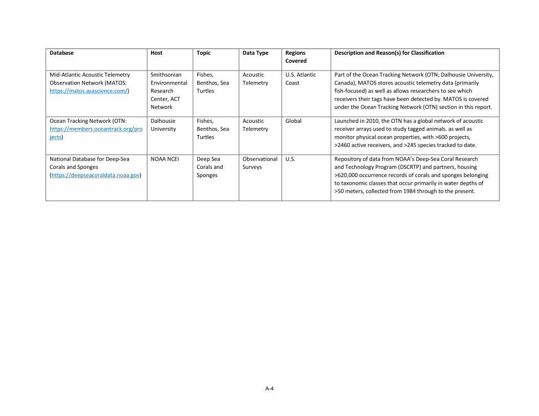
A-4
Database Host Topic Data Type Regions Covered
Description and Reason(s) for Classification
Mid-Atlantic Acoustic Telemetry Observation Network (MATOS: https://matos.asascience.com/)
Smithsonian Environmental Research Center, ACT Network
Fishes, Benthos, Sea Turtles
Acoustic Telemetry
U.S. Atlantic Coast
Part of the Ocean Tracking Network (OTN; Dalhousie University, Canada), MATOS stores acoustic telemetry data (primarily fish-focused) as well as allows researchers to see which receivers their tags have been detected by. MATOS is covered under the Ocean Tracking Network (OTN) section in this report.
Ocean Tracking Network (OTN: https://members.oceantrack.org/projects)
Dalhousie University
Fishes, Benthos, Sea Turtles
Acoustic Telemetry
Global Launched in 2010, the OTN has a global network of acoustic receiver arrays used to study tagged animals. as well as monitor physical ocean properties, with >600 projects, >2460 active receivers, and >245 species tracked to date.
National Database for Deep-Sea Corals and Sponges (https://deepseacoraldata.noaa.gov)
NOAA NCEI Deep Sea Corals and Sponges
Observational Surveys
U.S. Repository of data from NOAA’s Deep-Sea Coral Research and Technology Program (DSCRTP) and partners, housing >620,000 occurrence records of corals and sponges belonging to taxonomic classes that occur primarily in water depths of >50 meters, collected from 1984 through to the present.
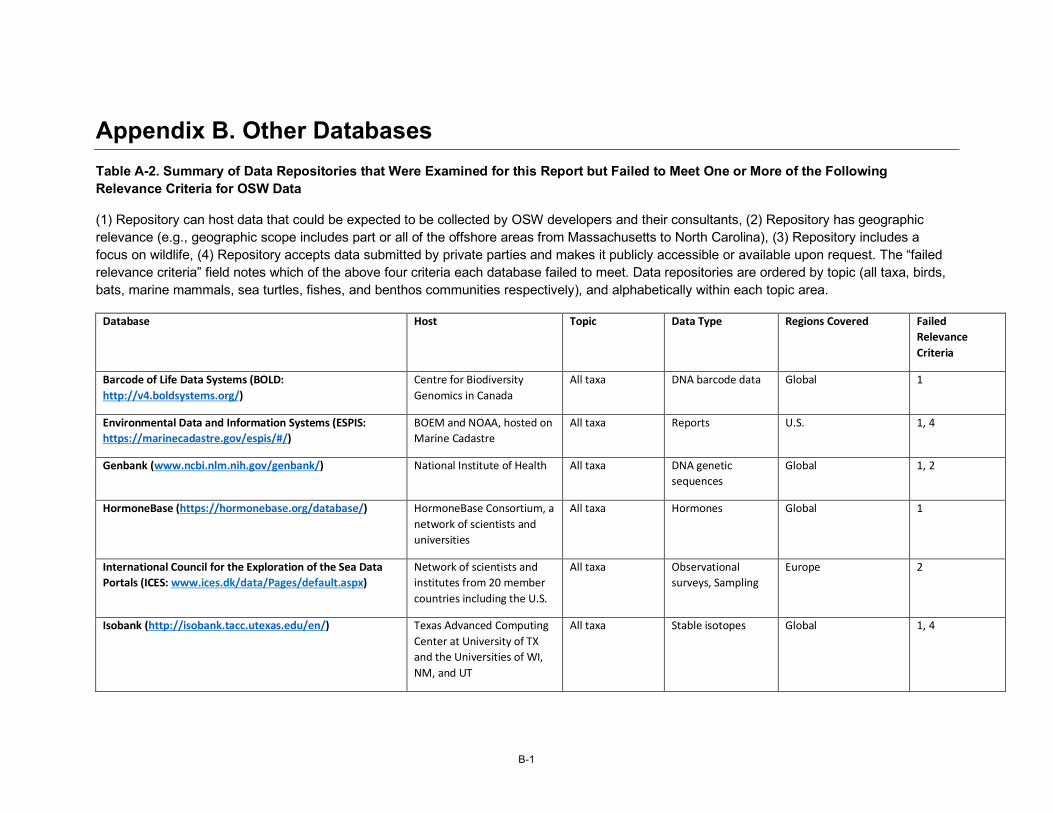
B-1
Appendix B. Other Databases Table A-2. Summary of Data Repositories that Were Examined for this Report but Failed to Meet One or More of the Following Relevance Criteria for OSW Data
(1) Repository can host data that could be expected to be collected by OSW developers and their consultants, (2) Repository has geographic relevance (e.g., geographic scope includes part or all of the offshore areas from Massachusetts to North Carolina), (3) Repository includes a focus on wildlife, (4) Repository accepts data submitted by private parties and makes it publicly accessible or available upon request. The “failed relevance criteria” field notes which of the above four criteria each database failed to meet. Data repositories are ordered by topic (all taxa, birds, bats, marine mammals, sea turtles, fishes, and benthos communities respectively), and alphabetically within each topic area.
Database Host Topic Data Type Regions Covered Failed Relevance Criteria
Barcode of Life Data Systems (BOLD: http://v4.boldsystems.org/)
Centre for Biodiversity Genomics in Canada
All taxa DNA barcode data Global 1
Environmental Data and Information Systems (ESPIS: https://marinecadastre.gov/espis/#/)
BOEM and NOAA, hosted on Marine Cadastre
All taxa Reports U.S. 1, 4
Genbank (www.ncbi.nlm.nih.gov/genbank/) National Institute of Health All taxa DNA genetic sequences
Global 1, 2
HormoneBase (https://hormonebase.org/database/) HormoneBase Consortium, a network of scientists and universities
All taxa Hormones Global 1
International Council for the Exploration of the Sea Data Portals (ICES: www.ices.dk/data/Pages/default.aspx)
Network of scientists and institutes from 20 member countries including the U.S.
All taxa Observational surveys, Sampling
Europe 2
Isobank (http://isobank.tacc.utexas.edu/en/) Texas Advanced Computing Center at University of TX and the Universities of WI, NM, and UT
All taxa Stable isotopes Global 1, 4
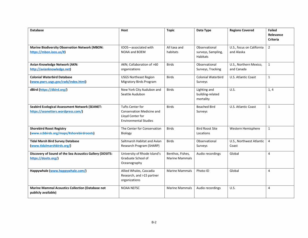
B-2
Database Host Topic Data Type Regions Covered Failed Relevance Criteria
Marine Biodiversity Observation Network (MBON: https://mbon.ioos.us/#)
IOOS—associated with NOAA and BOEM
All taxa and habitats
Observational surveys, Sampling, Habitats
U.S., focus on California and Alaska
2
Avian Knowledge Network (AKN: http://avianknowledge.net)
AKN; Collaboration of >60 organizations
Birds Observational Surveys, Tracking
U.S., Northern Mexico, and Canada
1
Colonial Waterbird Database (www.pwrc.usgs.gov/cwb/index.html)
USGS Northeast Region Migratory Birds Program
Birds Colonial Waterbird Surveys
U.S. Atlantic Coast 1
dBird (https://dbird.org/) New York City Audubon and Seattle Audubon
Birds Lighting and building-related mortality
U.S. 1, 4
Seabird Ecological Assessment Network (SEANET: https://seanetters.wordpress.com/)
Tufts Center for Conservation Medicine and Lloyd Center for Environmental Studies
Birds Beached Bird Surveys
U.S. Atlantic Coast 1
Shorebird Roost Registry (www.ccbbirds.org/maps/#shorebirdroosts)
The Center for Conservation Biology
Birds Bird Roost Site Locations
Western Hemisphere 1
Tidal Marsh Bird Survey Database (www.tidalmarshbirds.org/)
Saltmarsh Habitat and Avian Research Program (SHARP)
Birds Observational Surveys
U.S., Northwest Atlantic Coast
4
Discovery of Sound of the Sea Acoustics Gallery (DOSITS: https://dosits.org/)
University of Rhode Island’s Graduate School of Oceanography
Benthos, Fishes, Marine Mammals
Audio recordings Global 4
Happywhale (www.happywhale.com/) Allied Whales, Cascadia Research, and >15 partner organizations
Marine Mammals Photo-ID Global 4
Marine Mammal Acoustics Collection (Database not publicly available)
NOAA NEFSC Marine Mammals Audio recordings U.S. 4
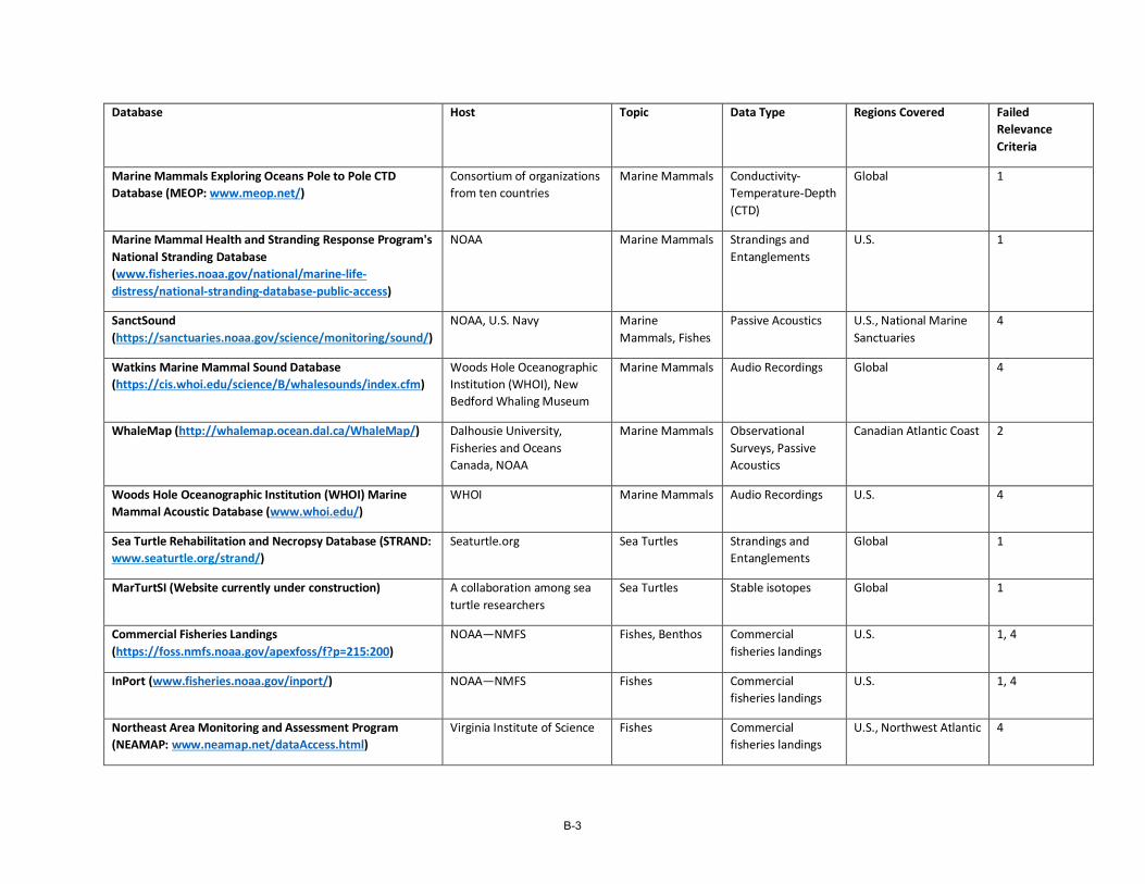
B-3
Database Host Topic Data Type Regions Covered Failed Relevance Criteria
Marine Mammals Exploring Oceans Pole to Pole CTD Database (MEOP: www.meop.net/)
Consortium of organizations from ten countries
Marine Mammals Conductivity-Temperature-Depth (CTD)
Global 1
Marine Mammal Health and Stranding Response Program's National Stranding Database (www.fisheries.noaa.gov/national/marine-life-distress/national-stranding-database-public-access)
NOAA Marine Mammals Strandings and Entanglements
U.S. 1
SanctSound (https://sanctuaries.noaa.gov/science/monitoring/sound/)
NOAA, U.S. Navy Marine Mammals, Fishes
Passive Acoustics U.S., National Marine Sanctuaries
4
Watkins Marine Mammal Sound Database (https://cis.whoi.edu/science/B/whalesounds/index.cfm)
Woods Hole Oceanographic Institution (WHOI), New Bedford Whaling Museum
Marine Mammals Audio Recordings Global 4
WhaleMap (http://whalemap.ocean.dal.ca/WhaleMap/) Dalhousie University, Fisheries and Oceans Canada, NOAA
Marine Mammals Observational Surveys, Passive Acoustics
Canadian Atlantic Coast 2
Woods Hole Oceanographic Institution (WHOI) Marine Mammal Acoustic Database (www.whoi.edu/)
WHOI Marine Mammals Audio Recordings U.S. 4
Sea Turtle Rehabilitation and Necropsy Database (STRAND: www.seaturtle.org/strand/)
Seaturtle.org Sea Turtles Strandings and Entanglements
Global 1
MarTurtSI (Website currently under construction) A collaboration among sea turtle researchers
Sea Turtles Stable isotopes Global 1
Commercial Fisheries Landings (https://foss.nmfs.noaa.gov/apexfoss/f?p=215:200)
NOAA—NMFS Fishes, Benthos Commercial fisheries landings
U.S. 1, 4
InPort (www.fisheries.noaa.gov/inport/) NOAA—NMFS Fishes Commercial fisheries landings
U.S. 1, 4
Northeast Area Monitoring and Assessment Program (NEAMAP: www.neamap.net/dataAccess.html)
Virginia Institute of Science Fishes Commercial fisheries landings
U.S., Northwest Atlantic 4
B-4
Database Host Topic Data Type Regions Covered Failed Relevance Criteria
Phytoplankton Monitoring Network (www.ncei.noaa.gov/products/phytoplankton-monitoring-network)
NOAA NCEI Plankton Sampling U.S. 1, 4
Mid-Atlantic Regional Association Coastal Ocean Observing System (MACAROOS: https://oceansmap.maracoos.org/)
IOOS No taxa. Oceanographic
Assorted data products
U.S., Northwest Atlantic 1, 3
Marine Geo Digital Library (www.marine-geo.org/library/) Lamont-Doherty Earth Observatory of Columbia University
No taxa. Deep Earth
Assorted data products
U.S. 3
Northeast Regional Association Coastal Ocean Observing Systems (NERACOOS: www.neracoos.org/datatools)
IOOS No taxa. Oceanographic
Assorted data products
U.S., New York Bight to Maine
1, 3
National Weather Service Database (NWS: www.weather.gov/gis/)
NOAA National Weather Service
No taxa. Weather NEXRAD Radar U.S. 1, 3, 4
EN-1
Endnotes
1 Data Quality and Documentation at Data.Gov https://www.data.gov/ocean/data-quality-and-documentation-subpage 2 Crown Estate Marine Data Exchange https://www.marinedataexchange.co.uk/ 3 European Marine Observation and Data Network http://www.emodnet.eu/ 4 California Offshore Wind Energy Gateway https://caoffshorewind.databasin.org/ 5 The NCEI is the result of a merger of the National Oceanographic Data Center, National Climatic Data Center, and
National Geophysical Data Center in 2015. 6 The Northwest Atlantic Seabird Catalog includes at-sea observations from all taxa, not just seabirds. 7 SeaScribe: A data collection tool from the Biodiversity Research Institute http://www.briloon.org/seascribe 8 Northeast Ocean Data Portal www.northeastoceandata.org/ 9 The State of the World’s Sea Turtles Project interactive map of sea turtle biogeography hosted by OBIS-SEAMAP
http://seamap.env.duke.edu/swot 10 The State of the World’s Sea Turtles Program https://www.seaturtlestatus.org/ 11 The R package Move for use with Movebank data https://www.movebank.org/cms/movebank-content/software 12 Motus Wildlife Tracking System Tag Registration Fee Schedule https://motus.org/wp-
content/uploads/2020/02/MotusTagRegistrationFeeScheduleFebruary2020.pdf 13 Developing Plans to Track Animals Offshore: Developing guidance for how to integrate automated radio telemetry
into pre- and post-construction monitoring plans for offshore wind farms http://www.briloon.org/renewable/automatedvhfguidance
14 North American Bat Monitoring Program guidance documents https://www.nabatmonitoring.org/new-resources 15 North American Bat Monitoring Program data explorer https://sciencebase.usgs.gov/nabat/#/home/explore-nabat-data 16 White-nose Syndrome Response Team https://whitenosesyndrome.org 17 Bat Acoustic Monitoring Visualization Tool https://visualize.batamp.databasin.org/ 18 Happywhale https://happywhale.com/home 19 NOAA Right Whale Sighting Advisory System https://apps-
nefsc.fisheries.noaa.gov/psb/surveys/MapperiframeWithText.html 20 ATN DAC Registration https://dacregistration.atn.ioos.us/accounts/login/?next=/ 21 Animal Telemetry Network Data Portal https://portal.atn.ioos.us 22 The FAIR Guiding Principles for scientific data management and stewardship are intended to provide guidelines to
improve the Findability, Accessibility, Interoperability, and Reuse of digital assets. https://www.go-fair.org/fair-principles/
23 Covering ARGOS Fees through the Animal Telemetry Network https://atn.ioos.us/help/argos/ 24 Animal Telemetry Network Data Portal https://portal.atn.ioos.us/ 25 NOAA ERDDAP data serverhttps://members.oceantrack.org/erddap/index.html 26 NOAA Deep-Sea Coral & Sponge Map Portal https://www.ncei.noaa.gov/maps/deep-sea-corals/mapSites.htm 27 Tethys: Environmental Effects of Wind and Marine Renewable Energy https://tethys.pnnl.gov/ 28 Whale Alert http://www.whalealert.org/ 29 BOEM Harnessing Citizen Science with New Ocean Alert Mobile App https://www.boem.gov/boem-harnessing-
citizen-science-new-ocean-alert-mobile-app 30 Citizenscience.gov is the official government website designed to accelerate the use of crowdsourcing and citizen
science across the U.S. government https://www.citizenscience.gov/# 31 WhaleMap https://whalemap.ocean.dal.ca/WhaleMap/ 32 BOEM Survey Guidelines for Renewable Energy Development https://www.boem.gov/renewable-energy/survey-
guidelines-renewable-energy-development
EN-2
33 USGS Data Management: Metadata Creation https://www.usgs.gov/products/data-and-tools/data-
management/metadata-creation 34 Tethys: A free open-source temporal-spatial database for metadata related to acoustic recordings
https://tethys.sdsu.edu/ 35 NOAA Coral Reef Conservation Program https://coralreef.noaa.gov/ 36 NOAA Plankton Data https://www.nodc.noaa.gov/General/plankton.html 37 Atlantic Coastal Cooperative Statistics Program https://www.accsp.org/ 38 Northeast Federal Fishery Dependent Data Visioning Project Industry Workshop: Final Report
http://134.209.208.5/sites/default/files/resource/final_fdd_workshop_report_91014.pdf 39 American Wind Wildlife Institute https://awwi.org/ 40 dBird—a citizen science database for bird mortality https://dbird.org/ 41 Marine Mammal Commission 2020 Grant Awards https://www.mmc.gov/grants-and-research-survey/grant-
awards/2020-grant-awards/ 42 National Center for Biotechnology Information: Fish of Chesapeake Bay
https://www.ncbi.nlm.nih.gov/bioproject/?term=498040 43 National Center for Biotechnology Information: Barcoding the Chesapeake Bay invertebrates
https://www.ncbi.nlm.nih.gov/bioproject/?term=396533 44 Automated Detection and Classification of Wildlife Targets in Digital Aerial Imagery
https://www.boem.gov/sites/default/files/documents/environment/environmental-studies/NT-19-04.pdf 45 Automated Detection and Classification of Wildlife Targets in Digital Aerial Imagery
https://www.usgs.gov/centers/umesc/science/deep-learning-automated-detection-and-classification-waterfowl-seabirds-and?qt-science_center_objects=0#qt-science_center_objects
46 Integrated Sentinel Monitoring Network (ISMN) for Change in Northeast U.S. Ocean and Coastal Ecosystems https://www.sentinelmonitoring.org/
47 Marine Biodiversity Observation Network—Gulf of Maine MBON https://marinebon.org/pages/gommbon/ 48 Integrated Sentinel Monitoring Network for Change in Northeast U.S. Ocean and Coastal Ecosystems: Science and
Implementation Plan: Ed. 1 https://www.sentinelmonitoring.org/wp-content/uploads/2020/10/ISMN_Plan_Edition_1_10_5_20.pdf
49 SeaScribe: A data collection tool from the Biodiversity Research Institute http://www.briloon.org/seascribe 50 Webinar on Regional Coordination of Data Platforms and Offshore Wind Related Data Collection on Habitat,
Fisheries, and Wildlife, hosted by NROC, MARCO, MARACOOS, and NERACOOS. October 2, 2020. 51 Regional Wildlife Science Entity https://www.nyetwg.com/regional-wildlife-science-entity 52 Responsible Offshore Science Alliance https://www.rosascience.org/

NYSERDA, a public benefit corporation, offers objective information and analysis, innovative programs, technical expertise, and support to help New Yorkers increase energy efficiency, save money, use renewable energy, and reduce reliance on fossil fuels. NYSERDA professionals work to protect the environment and create clean-energy jobs. NYSERDA has been developing partnerships to advance innovative energy solutions in New York State since 1975.
To learn more about NYSERDA’s programs and funding opportunities,
visit nyserda.ny.gov or follow us on Twitter, Facebook, YouTube, or
Instagram.
New York State Energy Research and
Development Authority
17 Columbia CircleAlbany, NY 12203-6399
toll free: 866-NYSERDAlocal: 518-862-1090fax: 518-862-1091

State of New York
Andrew M. Cuomo, Governor
New York State Energy Research and Development Authority
Richard L. Kauffman, Chair | Doreen M. Harris, President and CEO