Embed Size (px)
Citation preview
MARYLAND DEPARTMENT OF NATURAL RESOURCES
WILDLIFE AND HERITAGE SERVICE
WILDLIFE MANAGEMENT PLAN
For
INDIAN SPRINGS WILDLIFE MANAGEMENT AREA
15 YEAR VISION PLAN
Location
14038 Blairs Valley Road Clear Spring, MD 21722
In
Washington County Maryland
On Approximately
6,635 acres
Prepared by:
Maryland Department of Natural Resources Wildlife & Heritage Service
Indian Springs Wildlife Management Area 14038 Blairs Valley Rd
Clear Spring, Maryland 21722 301-842-2702
March 2014
Introduction The Maryland Department of Natural Resources, Wildlife & Heritage Service (WHS) is responsible for the management of approximately 106,000 acres of State property. These areas, entitled “Wildlife Management Areas” (WMA), encompass 44 separate tracts of land and are located in 18 of the 23 counties that make up the State. WMA’s range in size from as small as 20 acres to well over 29,000 acres, and represent most, if not all, of the major habitat types found throughout the State of Maryland. These properties make up a significant portion of the Department’s land holdings of approximately 440,000 acres. In 1940 the former Maryland Game and Inland Fish Commission made their initial purchase of 1,225.57 acres, with the property designed as a Wildlife Management Area and named after the small adjacent community of Indian Springs. At the time, this land was purchased using Pittman-Robertson Federal Aid in Wildlife Restoration (PR) funds. This 1937 federally enacted legislation provided reliable funding to state wildlife departments by placing a federal excise tax on sporting arms and ammunition, which are earmarked solely for wildlife conservation. WHS has the principal responsibility to lead in the management of Indian Springs WMA. In order to effectively establish long-term goals and objectives for its management of the area, a process was completed with the development of this 15-year management plan as an outcome. To meet specific goals set forth in this plan, the WHS will develop a five-year work plan that coincides with our five-year work plan for the WHS’s Federal Aid Grant. Specific goals and objectives for this WMA are consistent with the Statewide Mission and Goals Statement for Wildlife Management Areas. The mission of the WMA system is “to conserve and enhance diverse wildlife populations and associated habitats while providing opportunities for public enjoyment for the State’s wildlife resources through hunting and other wildlife-dependent recreation.” The Goals of the WMA system are: 1. To maintain, enhance and protect sustainable and diverse wildlife populations.
2. Create, enhance and protect appropriate habitats, natural communities and ecologically sensitive areas. 3. Conserve rare, threatened and endangered species by protecting the habitat that supports them. 4. With a focused emphasis on hunting, provide wildlife-dependent recreation on areas with minimal capital improvements or other development. 5. Provide a venue to educate citizens on the value and need of wildlife and plant communities through outreach, demonstration and sound management.

Physical Description The Indian Springs Wildlife Management Area (ISWMA) currently contains approximately 6,635 acres and is located in the northwest corner of Washington County, Maryland. The wildlife area is composed of four (4) tracts of land, which includes the Kuhns Ridge, Hickory Ridge, Fairview Mountain and Blairs Valley tracts. The management area is bordered to the north by the Pennsylvania/Maryland State line, the crest of Rickard Mountain to the east and Licking Creek to the west. The southern boundaries of the management area are less well-defined, with local public roadways delineating the southern extremes of the Kuhns Ridge, Hickory Ridge and the Blairs Valley tracts. These public roadways provide access to the various tracts and include Mooresville, Catholic Church, and Hanging Rock Roads. The fourth tract of land (Fairview Mountain) represents the southern extremity of ISWMA and is bounded to the south by MD Route 40. ISWMA is approximately 5 miles north of the small town of Clear Spring and 12 miles west of the City of Hagerstown. (See site location map). ISWMA is largely a forested tract of land, with approximately 92% of the WMA in a forested habitat and the other 8% composed of fields and small openings. The bulk of the fields are located within the Blairs Valley tract of the management area. ISWMA is located between the western edge of the Great Valley and the eastern edge of the Ridge and Valley Province of the Applachian Mountains. ISWMA is composed of a small group of mountains, which are entitled the Bear Pond Mountains. This mountain chain is surrounded by a landscape that includes a matrix of small parcels of farmland and large tracts of forested habitat. The Little Conococheague Creek, Lanes Run, and Rabble Run are the three main watersheds within the ISWMA, with all of them draining into the Potomac River. The Little Conococheague is located in the Blairs Valley section of the management area and provides the main water source to the 30 acre Blairs Valley Lake. This watershed is approximately 1600 acres in size, with a large portion of the watershed located to the north, in Pennsylvania. The Lanes Run and Rabble Run watersheds are 900 acres and 1200 acres in size, respectively. Both of these small streams are considered to have the highest quality water of all streams within Washington County. Climate, Topography, Soils and Hydrology ISWMA occurs within the Temperate Continental Rainy Climate, where there is no distinct dry season. Summers are usually hot and winters are mild. Regional features influencing the local climate include the Chesapeake Bay and the Atlantic Ocean to the east and the Appalachian Plateau to the west. The predominant direction of the wind is from the northwest in winter and the southeast in summer. Air masses arriving at Indian Springs are shadowed by the Allegheny Plateau to the west, which removes much of the moisture within them. This “rain shadow” effect results in Washington and Allegany counties receiving the least amount of rainfall when compared to other counties within Maryland. Indian Springs WMA lies on the eastern edge of the Ridge and Valley physiographic province, which is characterized by sandstones, shales and limestone. Mountain ridges within the management area extend in a general northeast-southwest direction and are
characterized by steep, narrow ridges and valleys. The major agriculture areas within ISWMA are in the Blairs Valley tract and to a lesser extent the southern section of Kuhns Ridge. Elevations range from a low of approximately 520 feet along Rabble Run to a high of approximately 1,840 feet on Bullskin Mountain, adjacent to the Pennsylvania State Line. Capital Improvements Because of the long acquisition history of Indian Spring WMA, there are a large number of capital improvements that have been acquired throughout the years. Beginning in the early 1940’s with the acquisition of the former Shank residence, located on the Kuhns Ridge tract, a total of 7 houses, one multi-purpose office and 15 various buildings have been assembled through the years. In addition, 6 bridges, 1 camping area, 1 small pavilion and a comfort station are also scattered throughout the management area. There are approximately 24 parking areas located on the property, 18 metal gates and 11 information boards associated with these parking areas. Furthermore, the Blairs Valley Lake was created in 1969 by constructing a 900- foot earthen dam across the Little Conococheague Creek, flooding approximately 30 acres of surface area. There is also a 1200-foot emergency spillway associated with the Lake as well as 1000 feet of wooden guard rails, a boat ramp, and two large paved parking areas. In addition to Blairs Valley Lake, another 1.5-acre impoundment can be found on the Kuhns Ridge Tract, which was acquired in the 1940’s. There are approximately 34 miles of boundary lines that need to be maintained as well as a 2 mile handicapped hunter trail and 9 miles of interior gravel surfaced roads. With such a high degree of capital improvements on the management area, the need for funding to maintain these improvements is a very high priority. The Department of Natural Resource’s Critical Maintenance Fund provides most of the funding source for maintaining these improvements. In accordance with Engineering and Constructions standards, all infrastructural maintenance, enhancement, redevelopment, design or new construction will be completed using Green Building design, technology, and construction materials. All infrastructure improvements must also meet ADA accessibility standards. Current needs include upgrading the water treatment system, riprap replacement along the upstream face of the Blairs Valley Dam, parking lot maintenance, exterior painting, roof replacement and access road/bridge maintenance and repair. Another source of funding has been the Recreational Trail Grant program, which has been used to replace several bridges and upgrade a number of roads within ISWMA. Other capital improvements needed for Indian Springs WMA include the design and construction of a new office facility to replace the current office. The current office, located in Blairs Valley, is an 1830’s log house with a brick veneer outside. Because of its age, it cannot support the current staff’s needs as most of the infrastructure is outdated or inadequate. In the spring of 2012 this office underwent an extensive renovation to stabilize this structure. Most of the former residences throughout Indian Springs are in various states of disrepair and are uninhabitable. These residences do not fit in to the overall management of the wildlife area and have been designated for razing. The former Shank and Beard houses,

located on the Kuhns Ridge tract where razed in 2012 and the remaining structures will be razed in the near future. All demolition and ground disturbance activities are subject to DNR’s Project Review process that includes the review and approval by the Maryland Historic Trust. MHT files indicate that 10 archeological sites and eight structures (or, in some cases, clusters of structures) have been inventoried within the WMA, including the 18th century Snyder Farm (WA-V-179) and the 19th century Mountain Road (WA-V-196). Many of these properties have already been determined to be ineligible for listing in the National Register of Historic Places, such as the Wibberly Cabin, the McKee-Leasure Farmstead, and the Greenville Log House. The Snyder Farm, however, which serves as the Indian Springs WMA office facility, has been determined to be ELIGIBLE for the National Register of Historic Places. In addition, the presence of the 10 archeological sites as well as the former residences and farmsteads that are found throughout the WMA indicate that the WMA has a moderate to high potential for containing additional archeological resources (both prehistoric and historic) that have not yet been identified. Acquisition Indian Springs WMA currently comprises approximately 6,635 acres. The wildlife area’s initial acquisition occurred in May of 1940, and has continued to the present time. A total of 24 separate land purchases comprise the WMA, with approximately 3,837 acres acquired using Federal Aid in Restoration Funds. Since 1969, Program Open Space has been the primary funding source for all of Department of Natural Resource’s land purchases. Any opportunity to acquire additional acreage for Indian Springs should be pursued, when appropriate, with in-holdings and adjacent tracts being a high priority. Particular attention should be made to connecting Kuhns Ridge to the rest of the management area. With such a high degree of development pressure in Washington County, acquisition is the most secure measure to conserve and protect wildlife habitat and open space.
Unique and Sensitive Areas The largely contiguous forest, topography, streams, vernal pools, and underlying geology of ISWMA support a variety of rare species and natural communities. The boundaries of 6 Ecologically Significant Areas (ESA’s) either overlap or are contained within ISWMA. Four of these ESA’s are classed as Tier 1 (Licking Creek, Hickory Ridge Ponds) or Tier 2 (Rabble Run Oak – Pine Barren, Boyd Mountain Pond) in Maryland’s Biodiversity Conservation Network (BioNet), indicating that they are critically or extremely significant for biodiversity conservation. Kuhns Ridge and Rabble Run Cabin Site ESA’s are classed as Tier 3 BioNet sites, indicating that they are highly significant for biodiversity conservation in the state. Maryland Biological Stream Survey data indicate that Rabble Run and Lanes Run are among the best streams in this region of the state. Licking Creek ESA, which includes Rabble Run, supports Illinois Pondweed (Potamogeton illinoensis, state rare) just downstream of the WMA boundary and a number of rare and protected plant species on the stream banks further to the south. In addition, two protected mussel species, Brook Floater (Alasmidonta varicosa, endangered) and Creeper (Strophitus undulatus, in need of
conservation), are found downstream in Licking Creek. An as yet unverified record for Green Floater (Lasmigona subviridis, endangered) was also recently reported from Licking Creek .Three rare plant species near the property are associated with sinkhole ponds. The state and federally endangered Northeastern Bulrush (Scirpus ancistrochaetus) is located in a sinkhole pond on private property very close to the WMA boundary (Hickory Ridge tract) and Pale Mannagrass (Torreyochloa pallida var. pallida, rare) and Sharp-scaled Mannagrass (Glyceria acutiflora, endangered) have been found along the edge of a seasonal sinkhole pond to the west of Fairview Mountain. Management practices, including forested buffers, should contribute to watershed-scale protection of streams, sinkhole ponds, and stream tributaries in order to maintain and improve water quality. Vernal pools on the WMA, including those on Hickory Ridge and east of Rabble Run, support Jefferson’s Salamander (Ambystoma jeffersonianum, rare) in addition to other amphibians. Vernal pool habitats are characterized by a wetland depression and upland forest life-zone buffer of at lease 300 feet. A forested upland buffer is critical for the life history of the species, as the wetlands are important areas for breeding and the uplands are used during the majority of the year when the pools are dry. Other small, seasonally-wet areas at scattered locations in the forested areas provide habitat for amphibians and many invertebrates. Two protected plant species on or adjacent to ISWMA, Striped Gentian (Gentiana villosa, endangered) and Lowland Loosestrife (Lysimachia hybrida, threatened), are recorded as being associated with wet habitats (moist, open woods; beaver pond areas). Extensive forested blocks on the WMA support a variety of Forest Interior Dwelling birds and other species (FIDS). Several forest areas approach 100 years in age and are starting to develop old growth forest characteristics. Maintenance of the largest, contiguous forest blocks by minimizing fragmentation from road openings and clearings will maximize habitat quality for these species and natural communities. Cliff and rock outcrop areas in this forested landscape support other unique species, such as nesting Common Raven (Corvus corax), Porcupine (Erethizon dorsatum, in need of conservation), Timber Rattlesnake (Crotalus horridus, rare), Butternut (Juglans cinerea, rare) and Allegheny Woodrat (Neotoma magister, endangered). In past years, the declining Golden-winged Warbler (Vermivora chrysoptera, rare) nested in the mixture of shrub, herbaceous, and tree habitat in the Blairs Valley tract. Several rare natural community types are present at Indian Springs WMA. Just upslope of Licking Creek, the Kuhn Ridge Shale Barrens ESA supports Rusty Woodsia (Woodsia ilvensis, threatened), and a rare shale barrens plant community. Hemlock areas along Licking Creek and oak-pine barrens with Table Mountain Pine (Pinus pungens) on Sword Mountain, Fairview Mountain, and Hickory Ridge also represent rare community types. A partially open oak woodland with sandy soils adjacent to the WMA supports state endangered, Northern Barrens Tiger Beetles (Cicindela patruela) on Hearthstone Mountain. This species has also been observed on Sword Mountain, within the WMA. They require natural disturbances such as fire to maintain their unique characteristics. Goundwater spring communities are another example of a rare community type found on ISWMA. A diverse assemblage of invertebrates inhabits these often overlooked habitats, with some species know to be exceedingly rare. At the northern base of Abe Mills Mountain is an exceptional example where the globally rare Appalachian spring snail (Fontigens bottimeri) and a rare and primitive dragonfly, the Gray Petaltail (Tachopteryx thoreyi), have been documented in a spring seepage area adjacent to the WMA.
Acquisition targets for property should include rare community types, ESA’s, and increased buffers for rare species and communities. Featured Species – Allegheny Woodrat is a keystone species at cliff and talus outcrops within ISWMA. An Appalachian native associated with wilderness areas, the woodrat or “packrat” caches large quantities of food and other items in protected crevices of rocks. A species unrelated to the much maligned introduced rat species of Eurasian origin, the Allegheny Woodrat is differentiated by its furry tail, white feet and underbelly, and large ears. Woodrats are remarkably tame though seldom observed by people due to their nocturnal habits and occupation of remote and rugged terrain. Within ISWMA, extant woodrat populations occur at Abe Mills Mountain and Sword Mountain. Woodrat occupancy has also recently been documented at rock outcrops on Rickard Mountain and Fairview Mountain. Additional habitat may occur in ISWMA or surrounding private lands. Population monitoring data at Abe Mills Mountain, via mark-recapture live trapping, reveal significant annual variation but, overall, a clear long-term decline that mirrors trends observed elsewhere in Maryland and throughout most of the species’ range. This population is isolated from those to the west at Roundtop Mountain and to the east in the Blue Ridge Mountains by expanses of agricultural land and developed areas. . The decline of the Allegheny Woodrat is due largely to fragmentation and degradation of its forested habitat. Deforestation directly limits the species ability to disperse and re-colonize extirpated areas. Landscape level forest fragmentation and associated availability of human-sourced food has dramatically increased Raccoon (Procyon lotor) populations and elimination of large hollow trees, forcing Raccoons to den in rock outcrops and subsequently exposing Woodrats to a deadly parasite carried by Raccoons. Loss of the American Chestnut tree (Castanea dentata) to blight and subsequent impasts of Gypsy Moth (Lymantria dispar) on oak species have reduced available overwintering foods for the woodrat as well. Management for the woodrat entails providing a landscape comprised of extensive and contiguous tracts of old forest with numerous embedded subpopulations allowing dispersal between sites without exposure to large open areas, development or high use roads. Mature to old growth forest with a diversity of mast producing trees for winter food caches, coupled with a variety of herbaceous plants and fungi, can provide year-round forage. A primary management boundary would include areas within 300 ft of rock habitat to include general foraging areas, though woodrats may travel 0.5 miles for preferred foods. Active management may be necessary in the future if severe loss of mast trees from exotic pests or blight-resistant strains of American Chestnut become available for restoration, otherwise promoting establishment of old growth forest with dynamic canopy gaps and large nut-producing overstory around rock habitats provides optimal habitat. Large hollow trees should be managed throughout ISWMA to provide alternative denning habitat for Raccoons to reduce parasite transfer to woodrats.

Recreational Use Public hunting is currently the primary recreational activity taking place on Indian Springs. Forest game species such as White-tailed Deer (Odocoileus virginianus), Gray Squirrel (Sciurus carolinensis), Ruffed Grouse (Bonasa umbellus) and Wild Turkey (Meleagris gallopavo) provide the majority of hunter paticpation. Within the upland and agriculture areas of Indian Springs, upland wildlife species such as American Woodcock (Philohela minor), Eastern Cottontail Rabbits (Sylvilgus floridanus), Mourning Dove (Zenaida macroura) and Northern Bobwhite (Colinus virginianus) are pursued, but to a much lesser degree. There are some limited opportunities for waterfowl hunting at Blairs Valley Lake and the smaller Indian Springs pond. Trapping for a variety of furbearing species is also popular, especially for Beaver (Castor canadensis) along the Little Conococheague Creek. There are a number of other outdoor activities that are actively pursued on ISWMA. In the early spring, mushroom hunting is a very popular pastime, as people from far and wide come to the area to collect fungi. Bird watching and hiking are also popular activities in the Blairs Valley area. Many people from the surrounding community enjoy trout fishing at Blairs Valley Lake and the smaller Indian Springs pond, as both are stocked with trout throughout the spring season. Field trials are another popular activity that takes place on the area. Each spring and fall numerous bird dog clubs sponsor working field trials for their dogs. Each field trial club releases quail for their dogs to find. Dogs are judged on their ability to find and point birds along with other attributes. Generally, six field trials are held every spring and in the fall. Approximately 400 acres of the agriculture fields within Blairs Valley have been designed for the field trial area. Because of Indian Springs WMA’s large size and close proximity to the metropolitan areas, the demand for public hunting, especially for forest game species, is only likely to increase with development. In addition to this demand for hunting opportunities there is a general assumption that there will also be an increasing demand for other non-hunting uses on the WMA. These other uses include mountain biking, horseback riding, hiking, wildlife photography, and bird watching. In accordance with Federal Aid in Wildlife Restoration Guidelines, only wildlife-dependent recreation will be promoted or allowed on the area.
Potential Threats and Concerns There are many potential threats and concerns that could have a negative impact on wildlife populations and their habitats on Indian Springs WMA. Because the management area is in close proximity to the Baltimore/Washington metropolitan area there is a great demand for residential development in Washington County. Over the last several decades there have been many homes built adjacent to the management area. Many of these homes have been constructed within important wildlife corridors and unique habitats, resulting in the loss of these areas. As the surrounding area becomes more developed, there is an increased demand for areas to support other non-wildlife dependent recreation such as hiking and mountain biking. These activities require marked trails, which could have the potential to open the wilder sections of the management area, negatively affecting wildlife populations. Other threats to the area include the introduction of

various invasive plants, insects, and diseases. The Gypsy Moth, for example, has severely impacted the forest community on the management area as well as the surrounding countryside. Long Term Goals for Indian Springs WMA Long term goals have been developed for Indian Spring WMA. The purpose of the long-
term goals is to provide a broad overview of the management objectives for this property. The detailed management objectives for particular tracts are contained in the HMU descriptions. The long-term goals for the Indian Springs WMA are to:
Maintain and manage current levels of public access for recreational use and resource protection.
Conserve, protect, and, as appropriate, restore natural communities and sensitive habitats, including old growth forest, embedded within a forested matrix that minimizes fragmentation and invasive plant species. Conserve, protect and, as needed, manage for and restore populations of rare, threatened and endangered species.
Maintain and promote hunting and trapping opportunities for forest game, upland game, furbearers and migratory waterfowl, with a special emphasis on forest game species. Enhance and maintain diverse habitat types, with a focus on native species. This goal will center on maintaining a mixture of early successional habitats, herbaceous openings, shrub/scrub habitat and mixed hardwood stands with various age structures. Maintain and enhance current infrastructure using Critical Maintenance Funds to ensure a safe and efficient work environment. Pursue Capital Improvement Funds to develop a new Work Center, raze old buildings, maintain lake and develop a chemical storage building. Pursue all potential acquisitions involving in-holdings and adjacent areas to insure long-term protection of recreational goals and natural resources on Indian Springs WMA. Evaluate success of management activities and progress toward HMU goals and adjust activities accordingly.
Habitat Management Units
To facilitate the development of the various HMU on the management area the property was divided into 4 separate tracts of land. Each tract was further divided into different HMUs based on slope, forest composition, aspect, sensitive species, present land use and

a variety of other factors unique to each area. Once HMUs were identified, specific goals and objectives are developed for each unit. Unit descriptions include Key Wildlife Habitats as described in Maryland’s 2005 Wildlife Diversity Conservation Plan, which can be found at www.dnr.state.md.us/wildlife/divplan.
Kuhns Ridge Tract The Kuhns Ridge Tract is located on the far western portion of the management area and contains 3 different HMUs. The tract is composed of approximately 951 acres with 758 acres in forest cover, 139 acres of old fields and hedgerow habitat and approximately 54 wetland areas. Most of the property was assembled during 1940, 1957 and 1977. A 60 acre parcel was recently acquired in 2009. It is surrounded by private property with most of the surrounding land owned by hunting clubs. Licking Creek borders a small portion of this tract to the west. Access to the area is from Kuhns Ridge Road, Slabtown Road and Pectonville Road. There were several structures located within this HMU, include the former Shank and Beard residences, the Indian Springs Pond, the Handicapped Hunting Trail and a number of other structures associated with prior farming operations. All of these building have been razed, with the exception of the small Shank barn. HMU 1 – Kuhns Ridge Tract Unit Description: Agricultural, Mesic Deciduous Forest, Early Successional Forest, Barrens and Dry Glades HMU 1 is approximately 261 acre in size and is bordered by private lands to the west and north, a public road to the east and public lands to the south. The aspect of this unit is mostly west. This unit is predominantly a mixed oak forest in the immature to mature size class. In the early 1990’s, a 23 acre regeneration harvest took place in the northern portion of this unit to increase the amount of early successional forest type within the area. This unit is a popular hunting area for forest game species, with special emphasis on Eastern Wild Turkey and Ruffed Grouse hunting opportunities. Approximately 3 miles of the Tuscarora Trail is located adjacent to this unit and follows the ridge line of Kuhns Ridge. There is also a unique Eastern Hemlock (Tsuga canadensis) community in the southern portion of the HMU. This hemlock community has been part of a research study on the hemlock woody adelgid (Adelges tsugae) by the Maryland Department of Agriculture. However, only a small portion of this hemlock community is within the boundaries of ISWMA. Most of this unique community is on private property adjacent to Licking Creek. WHS has documented the occurrences of several State rare, threatened and endangered (RTE) species within this unit. Unit Goal: This unit will be managed to protect the existing forest communities, with special emphasis on RTE species. The area is currently providing good habitat for a variety of forest game species. Any management considerations will be approached with sensitivity for RTE species and unique forested and shale barrens habitats. Objective:

Protect, conserve, and, when appropriate, restore sensitive habitats for RTE and distinctive forested communities. Strategies: Minimize disturbances in areas with RTE plant species.
Pursue any and all opportunities to acquire property adjacent to Licking Creek, to protect the unique forested and shale barren habitat. Maintain important riparian boundary adjacent to Licking Creek as this area provides valuable nesting and feed habitat for a variety of forest interior dwelling bird species and will protect unique shale barren habitats. Forested stream and tributary buffers of at least 300 feet are critical to protect rare aquatic species in Licking Creek.
HMU 2 – Kuhns Ridge Tract Unit Description: Mesic Deciduous Forest, Early Successional Forest This 463 acre unit is divided into two separate areas, with the larger section encompassing approximately 373 acres and the other smaller portion containing approximately 90 acres. The aspect for the larger tract is predominantly west, east and north. Kuhns Ridge Road defines the western boundary of the larger tract, with Mooresville Road to the south and private property to the north and east. The smaller tract has an aspect towards the southwest, with Slabtown Road providing the major access to this section. HMU 2 is composed of mostly upland oak forest habitat in the immature size class with significant areas of mature oaks. In addition, there are several blocks of Virginia Pine (Pinus virginiana) within this unit. Within the larger section of this HMU, there are approximately 30 to 40 acres that are in the small tree to pole size age class. These stands are a result of several clear cuts that were completed in the early to mid 1980’s to improve the habitat for Ruffed Grouse and White-tailed deer. In addition, there area a few pockets of Quaking aspen (Populas tremuloides) that have been maintained by regeneration and release throughout the area. A small, unnamed intermittent tributary is located in the middle of this tract and flows in a southerly direction, eventually joining Rabble Run in the southeast. An old home site is located in the northwest section of this unit, however this structure is completely fallen down and only remnants are left. There is an extensive infestation of the exotic plant periwinkle (Vinca minor) associated with this old homesite that is spreading into the adjacent forest. Located to the south, in close proximity to Rabble Run, is a small 1-2 acre area, which has been maintained as a Ruffed Grouse and American Woodcock demonstration area. A variety of fruit producing trees have been planted over the years and include, Apple (Pyrus malus), Hawthorn (Crataegus spp), and Crabapple (Pyrus spp). A number of conifers have also been planted throughout this area to provide thermal cover. A one (1) mile section of the handicapped hunter trail has been constructed and maintained in this area to provide forest hunting opportunities for the mobility impaired. Unit Goal:
This HMU will be managed to promote habitat for forest and upland wildlife, with an emphasis on Ruffed Grouse and American Woodcock hunting. The forested area will be managed to maintain and increase the current amount of sapling/small tree age classes. By maintaining early succession and edge habitat, forest and upland wildlife species such as Eastern Cottontail, American Woodcock, Ruffed Grouse, White-tailed Deer and Wild Turkey will benefit by improved feeding areas, nesting habitat and important brood rearing habitats. Maintaining the handicapped hunter trail will be a high priority. Objective: Maintain and create early successional forest habitat for forest game hunting opportunities. Strategies: Regularly use forest management practices, either commercial or non- commercial, to maintain early successional forest habitats. Maintain and expand aspen stands by releasing and regenerating as needed. Maintain small wildlife openings and woods roads by mowing to provide brooding areas for Ruffed Grouse and Wild Turkey poults. Objective: Maintain adequate forest buffers along tributaries to Rabble Run and Licking Creek and allow them to mature to older forest habitat that can support Forest Interior Birds. Strategies: Maintain a forested buffer of at least 300 feet along waterways. Objective: Reduce threats to native forest communities from disease, harmful insects, and invasive species. Strategies: Monitor area for threats such as disease, harmful insects, and invasive species and act accordingly. Control exotic periwinkle near old home site. Objective:

Provide quality access for wildlife dependant recreation. Particular attention should be given to the handicapped hunter trail.
Strategies: Conduct regular preventive maintenance to trails, parking areas and information boards. Seek DNR critical maintenance funding and other sources to maintain infrastructure. Limit motorized vehicle access during the non-hunting season. Objective: Maintain Ruffed Grouse and American Woodcock demonstration area. Strategies: Release and prune Apple trees to promote fruit production. Continue to rotationally mow herbaceous opening. Periodically remove competing vegetation for conifers and other planted trees. HMU 3 – Kuhns Ridge Tract Unit Description: Agricultural, Mesic Deciduous Forest, Early Successional Forest This 255 acre unit is divided into two separate areas, with the larger section located to the south and the other portion to the east of this HMU. The southern portion of this unit is approximately 125 acres and is composed of the former Beard farm that was acquired in 1977. This area includes the former farmstead and bank barn (ca.1920). Approximately 92 acres of the area is made up of small open fields and hedgerows. The open habitat within this unit has been managed for more than 30 years through rotational mowing, annual food plots, hedgerow maintenance and warm season grass plantings. Approximately 14 acres of upland oak forest habitat exist within this unit and is in the immature size class with pockets of mature oaks scattered throughout the area. In addition, there are a few blocks of mature Virginia Pine within this unit. The second portion of this unit is composed of approximately 130 acres and encompasses the entire former Shank farm, which was purchased in 1940. Former residences, spring house, shop, and barn are located within this unit. Prior to 1977 the small shop building served as the main office for the Indian Springs staff. Approximately 43 acres of this area is made up of small fields, hedgerows and warm season grasses plantings. In addition, the 1.5 acre Indian Spring pond in located within this unit. This pond is stocked with trout in the spring and is a popular fishing area. Furthermore, a large portion of approximately 2 mile handicapped hunter trail is found within the unit. In the summer of
2009 and again in 2010, approximately 16 acres of this area was treated with an aerial application of herbicide to kill an infestation of exotic Kudzu vine (Pueraria lobata). Unit Goal: This unit will be managed to maximize early successional habitat for forest and upland wildlife. The forested areas will be managed to maintain and increase the current amount of sapling/small tree age class. By maintaining early succession and edge habitat, forest and upland wildlife species such as Eastern Cottontail Rabbits, American Woodcock, Ruffed Grouse, White-tailed Deer and Wild Turkey will benefit from improved feeding areas, nesting habitat and important brood rearing habitats. Maintaining the handicapped hunter trail will be a high priority. Objective: Create, maintain and enhance upland and early successional forest habitats. Strategies:
Maintain areas in herbaceous cover and crops beneficial to wildlife. Plant a variety of crops to benefit various wildlife species at different times of the year. Perennial grass and clover plantings should be a priority to provide soil stabilization, forage, and game bird brood habitat. Throughout spring and summer create and maintain mowed strips of herbaceous cover to provide breeding and forage habitat for Eastern Cottontail Rabbits, Ruffed Grouse and Wild Turkey poults. . Plant larger fields in warm season grasses to provide nesting and escape cover for Cottontail Rabbits.
Maintain warm season grass fields by controlled burning on a 3 year rotation. All burning should be completed outside of the grassland bird nesting season. Whenever possible, leave vegetation standing throughout the winter to provide cover and food.
Continually monitor and maintain hedgerows in a low cover shrub stage. Continually monitor and maintain early succession edge habitat around field edges. Evaluate Virginia Pine stands for harvest. Regularly use forest management practices, either commercial or non-commercial, to maintain early successional forest habitat. Complete routine annual assessments of plantings and adjust accordingly.
Objectives:
Manage area for forest dependent wildlife hunting opportunities and evaluate area for upland hunting opportunity with an emphasis on Ruffed Grouse and American Woodcock.
Strategies: Complete a detailed forest inventory and incorporate forestry recommendations. Conduct timber harvest where appropriate to create a mixture of different age classes. Forest management will focus on improving the unit for Ruffed Grouse and American Woodcock. Provide vegetative buffer (minimum 100 feet forested habitat) along Rabble Run and tributaries to minimize temperature fluctuations and reduce sedimentation. Objective: Provide quality access for wildlife dependent recreation. Strategies: Conduct regular maintenance to handicapped hunter trail, parking areas and maintain information boards. Objective: Reduce impacts of invasive plant species. Strategies: Treat areas using BMP’s to eliminate invasive exotic plants. Hickory Ridge Tract The Hickory Ridge Tract is located in the west/central portion on the management area is composed of 3 different HMUs. The tract is composed of approximately 2,533 acres and is the largest assemblage of forested property on ISWMA. Of the 2,533 acres, approximately 2,370 acres is in forest cover of various age classes and 163 acres of old field/orchard habitat. Acquisition of this tract consisted of 10 different purchases, with acquisition starting in 1940 and the most recent purchase in 1998. The Hickory Ridge tract is bordered to the east by the AT&T Road and to the south by Catholic Church Road. Indian Springs Road defines the western boundary and the Maryland/Pennsylvania State Line defines the northern limit of the tract. Most of the surrounding property is in forested habitat and owned by private hunting clubs. There are a few small family farms to the south and west that are used for cattle production. Access to the Hickory Ridge tract is from Indian Springs Road, Catholic Church Road and the AT&T Road. There are
several structures within this tract which include the Greenville cabin and the former Wibberley cabin. The Greenville cabin, located to the southeast, is a small hand-hewn log house of simple construction and dates from the late nineteenth century. There are no other structures associated with this particular building. However, there are a number of old stone foundations, which suggest that at one time this was a small working farm. In addition, there is evidence of apple production in the area behind the house as there appears that the land was once terraced. The Wibberley cabin, located within the central portion of the unit, became State property when it was purchased in 1983. It is located in a very remote section of the management area and was used as a hunting lodge by the previous owners. It is a more modern building, constructed of concrete and cinder block. Adjacent to the Wibberley cabin is another old house, which dates from the early nineteenth century and was part of a working farm many years ago. All of these buildings are in various stages of disrepair and have not been used for many years. Located approximately several hundred yards west of the Wibberley Cabin is a small graveyard. This grave site contains only one gravestone, which is dated from the mid-1800s. Another small graveyard is found within this tract in the west northwest section of Hickory Ridge. This grave site contains one small headstone, which is unreadable due to its age. HMU 1 - Hickory Ridge Tract Unit Description: Mesic Deciduous Forest, Dry Oak-Pine Forest
HMU 1 is a very large unit composing of approximately 1,394 acres of forested habitat. This unit extends from the northern boundary with Pennsylvania to the southern reaches of the management area adjacent to Catholic Church Road. Much of this unit is associated with the stream valley of Rabble Run, except for one small tributary, with large areas of upland forest located to the north and south. This HMU is entirely forested with the exception of a small opening located adjacent to the former Wibberley cabin. There are a number of small un-named tributaries, which originate upslope and drain into Rabble Run below. Much of this unit is associated with steep to moderately sloping lands. There is one large area of open water that is a natural beaver impoundment. Most of the other water features are limited to the stream channel, with the exception of a few spring seeps along the valley floor adjacent to the stream. Most of these seeps appear to dry out during the summer season. Many parts of this unit are very steep and rocky, which limits any potential opportunity for active management. Towards the southern end of this unit is a fairly large section dominated by Chestnut Oak (Quercus prinus), with some Table Mountain Pine (Pinus pungens) and an understory of mainly Low Bush Blueberry (Vaccinium spp). It appears that this unique community is the result of very acidic conditions resulting from the underlying soils. In addition to this unique plant community, there are a number of small natural depressions on the forest floor. During the spring, these depressions fill with water and provide important vernal pool spring breeding locations for a host of amphibian species. Furthermore, there are approximately 6 acres of open fields and edge habitat. Approximately 25-30 acres are represented by past regeneration cuts that appear to have been completed during the early 1980’s. These former cuts are composed of pole sized trees, with an open understory. There are several small stands of aspen scattered within the unit, which have been

maintained by regeneration and release. Also within the unit are a number of locations that have experienced extensive Gypsy Moth impacts over the years. Unit Goal: This unit will be managed to maintain current forest conditions and allow the forest to progress to an older growth forest. Fragmentation of larger forest blocks should be minimized to support Forest Interior Birds and other species. Watershed-scale protection should be considered to maintain the high quality of Rabble Run. Recreational hunting and birding opportunities will continue to be promoted within the unit. Objective: Maintain high quality forested habitats and allow them to develop older growth forest conditions. Strategies: Monitor for threats to forest from insects, disease or invasive species. Use best management practices to treat area and protect rare species and habitats. Minimize fragmentation of large forest blocks and road openings or clearings. Objective: Conserve and protect vernal pools and unique plant communities. Strategies: Maintain forested buffer of at least 300 feet around vernal pools and other wetlands. Monitor for threats from insects, disease or invasive species. Use best management practices to treat and protect rare species and habitats. Consider reintroduction of fire to maintain rare oak-pine communities. Continue to monitor riparian forest habitat for stand diversity and forest composition. Objective: Maintain high quality of Rabble Run through watershed-scale protection of the stream and its tributaries. Strategy: Maintain forested cover throughout the watershed. Provide vegetative buffer (minimum 300 feet of forested habitat) along Rabble Run and tributaries to
minimize stream temperature fluctuations, reduce sedimentation, and provide habitat for nesting forest interior birds. Objective:
Maintain existing roads, wildlife openings and Aspen stands using best management practices and in a manner that is compatible with other objectives for this HMU.
. Strategy:
Maintain roads in current conditions by rotational mowing, grading and clearing on an as needed basis and in a manner that is compatible with other objectives for this HMU.
.
Maintain approximately 6 acres of wildlife openings within the unit and field border cuts as needed.
HMU 2 - Hickory Ridge Tract Unit Description: Agricultural, Mesic Deciduous Forest, Early Successional Forest This unit encompasses the western portion of the Hickory Ridge Tract and contains a total of 1032 acres of a mixture of forest habitat and open herbaceous fields. Approximately 89 acres of the total acreage mention above is composed of open herbaceous fields, hedgerows and edge habitat. All of these open areas are located in the southwest corner of the unit and have been maintained by rotational mowing, food plots and hedgerow improvement. There is evidence scattered within this unit of former orchard production as there are several areas within the HMU that appear to have been terraced. In addition, several old stone foundations can be found within this area suggesting that at one time the area was a farmed. All of the former orchards are gone and these areas are overgrown with mature/immature forests and a thick understory of multiflora rose. The main access road to the Hickory Ridge Tract is located within this unit and is a major access point to this portion of the management area. Several un-named intermittent tributaries to Rabble Run are found within the unit. Also within this unit is the location of several Indian Springs mast survey plots. There are 4 different survey plots located throughout the Hickory Ridge area. Each plot contains 10 marked trees of the white oak group and 10 trees of the red oak group. During late summer each tree is evaluated for their acorn production to determine the amount of mast that will be available to wildlife the coming fall. These plots have been surveyed for over 40 years. Other unique features within the HMU included several small manmade wetland areas. These wetlands are the result of using dynamite to blast small depression into the ground
to collect water. Years ago, former managers of ISWMA used dynamite to create these depressions with the thought that the lack of water was a limiting factor for wildlife. Approximately 6 of these wetlands are located throughout the Hickory Ridge Tract and were created during the 40’s through the early 60’s. Due to the danger inherent with using dynamite this practice is no longer used. A state and federal endangered plant, Northeastern Bulrush, is located just outside of the northwest boundary of this HMU on private property. Approximately 62 acres within this HMU is comprised of several old regeneration cuts that are now in the pole size age class. These regeneration harvests appear to have occurred during the early to mid 1980’s. Most of the remaining forest is a mature/immature stand with a number of localized areas experiencing significant mortality from Gypsy Moth infestation. Also found scattered throughout the unit are pockets of aspen that have been maintained by regeneration cuts or released from competing vegetation. Because of the easy access to this particular unit it is a very popular hunting area for a variety of forest game species, with Ruffed Grouse, White-tailed deer and Wild Turkey readily pursued. Unit Goal: This particular unit will be managed to maintain the area in a mosaic of different age classes including early successional forest, older growth forests and edge habitat. The location of this unit with its close proximity to existing roads and parking areas, and its popularity with forest game hunters makes this unit well suited for early successional forested habitat. Game species such as American Woodcock, Ruffed Grouse and White-tailed deer should benefit from improved cover, feeding and brooding areas. Older growth forests will be allowed to continue to mature, which will provide critical habitat to a variety of forest interior dwelling birds. Objective: To maintain and improve early successional forest habitat, older forest habitat, edge habitat and old field habitat. Strategies: Conduct a thorough and detailed forest analysis and incorporate forestry recommendations.
Conduct timber harvest when and where appropriate to create a patchwork of older forests and seedling to sapling forest stands.
Maintain woods roads and wildlife openings by rotational mowing to provide important brooding habitat for Ruffed Grouse and Wild Turkey poults. Continue to daylight and maintain road edges in early successional cover by commercial and non-commercial methods.
Monitor for threats from insects, disease or invasive species. Use best management practices to treat areas and protect rare species and habitats. Objective: Protect water quality and integrity of federally-listed wetland plant species (located off of property). Strategies: Limit forest harvest as needed to protect sinkhole ponds adjacent to ISWMA. Provide minimum 300 feet maturing forest buffer along seasonal drainages and tributaries to minimize stream temperature fluctuations and reduce sedimentation. Objective: Continue to provide quality access for wildlife dependent recreation, especially for forest game hunting opportunities. Strategies: Conduct annual maintenance to access roads, parking areas and Kiosks. Limit motorized access with seasonal gate closures to provide quality walk-in experience. Monitor for insects, disease and other negative impacts to stand and act accordingly. HMU 3 - Hickory Ridge Tract Unit Description: Agricultural, Mesic Deciduous Forest, Early Successional Forest HMU 3 lies in the southeast corner of Hickory Ridge adjacent to the AT&T Road. A small un-named seasonal stream flows along the eastern boundary, with Rabble Run defining the southern reaches of the unit, private property is to the west. This 108 acre unit has predominantly a west aspect and is composed of the former Greenville farm. Approximately 24 acres are in open herbaceous fields, hedgerows, edge habitat. The fields have been maintained by rotational mowing, food plots and hedgerow maintenance. There is evidence within this unit of former orchard production as there are several areas within the HMU that appear to have been terraced at one time. All of the former orchards are gone and these areas are overgrown with mature/immature forests and a thick understory of multiflora rose. The old Greenville cabin is a small hand-hewn two story log house that dates from the late 19th century and is the only structure in the
unit. Several old stone foundations can be found within this area suggesting that at one time the area was a farmed. HMU 3 is composed of mostly an oak forest stand, however, as you move south Tulip Poplar (Liriodendron tulipifera) becomes more dominant and the stand takes on cove hardwood forest characteristics. Unit Goal: This area will be managed to provide and maintain a diversity of habitat types, including early successional areas, older forest stands, soft edge and day lighted areas. Having a variety of habitat, which is easily accessible from nearby parking areas promotes excellent hunting opportunities for a wide variety of forest and upland game species. Improving early successional habitat will enhance populations of game species such as American Woodcock, Ruffed Grouse and White-tailed Deer by increasing the amount of cover, food and brooding habitats. Providing hunting, trapping and birding opportunities will be a high priority for this unit. Objective:
Improve early successional forest habitat, edge habitat and herbaceous field habitat.
Strategies: Conducted a through and detail forest analysis and incorporate forestry recommendations. Conduct timber harvest when and where appropriate to create a patchwork of older forests and seedling to sapling forest stands. Maintain interior woods roads and wildlife openings by rotational mowing to provide important brooding habitat for Ruffed Grouse and Wild Turkey poults. Continue to daylight and maintain road edges in early successional cover by commercial and non-commercial methods.
Monitor forest stands for threats such as insects, disease and non-native and invasive plants. Use best management practices to treat area if possible and so that rare species will not be impacted.
Objective: Conserve and protect forest buffers adjacent to seasonal tributaries and Rabble Run. Strategies: Provide minimum 100 feet of maturing forested buffer along seasonal drainages and tributaries to minimize stream temperature fluctuations and reduce sedimentation.
Objective: Provide quality access for wildlife dependent recreation. Strategies: Conduct annual maintenance to access roads, parking areas and Kiosks. Limit motorized access with seasonal gate closures to provide a quality walk-in experience. BLAIRS VALLEY TRACT The Blairs Valley Tract is the most eastern section of Indian Springs WMA and contains approximately 2,310 contiguous acres. This tract has been divided into 3 different habitat management units or HMU’s. These HMU’s are composed of 487 acres of old field and hedgerow habitat, 1,762 acres of forest cover and approximately 61 acres of wetland areas. The Blairs Valley Tract is bordered to the north by the PA/MD State line, to the south by Hanging Rock Road and the eastern boundary follows the crest of Rickard Mountain. The western boundary is less defined with sections of the management area bordering Rabble Run, Hearthstone Mountain and portions of the AT&T Road. The Blairs Valley tract is surrounded by private property in small residential development, with larger tracts of forested area owned by local hunting clubs. Most of the Blairs Valley property was assembled during the mid 1960’s, with one additional 150 acre parcel added in 2002. In early 2011, a 484 acre easement was obtained from the Washington County Sportsman Association located along the eastern boundary of ISWMA. This perpetual conservation easement will protect over 2 miles of shared common boundary along the crest of Rickard Mountain. There are a large number of structures scattered throughout Blairs Valley including the former Bragunier residence, barn and shop building. The multi-unit office, a workshop and storage building, camping area, field trial pavilion, several bridges and numerous parking areas and interior roads are located throughout the tract. The 30 acre Blairs Valley Lake is located within this area as well.
HMU 1 – Blairs Valley Tract Unit Description: Mesic Deciduous Forest, Dry Oak-Pine Forest, Barrens and Dry Glades, Cliffs and Rock Outcrops This HMU contains approximately 874 acres and encompasses the ridge top and associated side slopes of Sword Mountain. On the east side of Sword Mountain, this HMU reaches down slope until approximately the 900 foot elevation. On the west side this HMU continues down slope until it reaches the Bear Pond Hollow Road. All of this HMU is comprised of forested habitat in the immature to mature forest age class. Habitats on Sword Mountain are quite varied, with areas dominated by mixed oaks, but also Table Mountain Pine and Pitch Pine (Pinus rigida) where an extensive fire in 2000 allowed this rare forest type to regenerate. Small barrens, open woodland, and rock
outcrops are also present. Located to the southwest on the east slope of Sword Mountain is a 3.5 acre private residence, which is surrounded by State land. This entire unit is composed of mountain slopes, which are gently sloping to moderately sloping lands with extremely steep slopes closer to the ridge top of Sword Mountain. There is a powerline right-of-way, which runs through this unit that is maintained by AT&T. Unit Goal: This unit will be managed to provide important habitat for a variety of wildlife species. Mountain ridges provide important travel corridors for a wide array of wildlife. Black Bears (Ursus americanus), Bobcats (Lynx rufus), and a wide variety of migratory birds use mountain ridge tops to move from place to place. Small shale barrens and open woodlands support state endangered Northern Barrens Tiger Beetles, and rocky outcrops support state endangered Allegheny Woodrats and other rare species. Current forest conditions will be maintained and the forest will be allowed to mature and develop older forest conditions. Recreational hunting and birding opportunities will continue to be promoted within this unit. Objectives: Allow stand to age while monitoring for forest integrity, stand diversity and structural diversity. Protect and maintain rare habitats. Strategies: Monitor for threats to forest from insects, disease or invasive species. Use best management practices to treat area and protect rare species and habitats. Maintain natural disturbances such as fire for oak-pine, open woodlands, and shale barrens communities. Minimize fragmentation of forest tracts by roads or other features and provide at least a 300 foot buffer around rock outcrops. Leave large, hollow trees to provide alternative dens for Raccoons to reduce impacts on Allegheny Woodrat. Objective: Provide quality access for wildlife dependent recreation. Strategies: Conduct annual maintenance to access roads, parking areas and Kiosks. Limit motorized access with seasonal gate closures to provide a quality walk-in experience. Maintain existing road daylighting along the Bear Pond Rd. in a manner that is
compatible with other objectives for this HMU.

HMU 2 – Blairs Valley Tract Unit Description: Agricultural, Early Successional Forest, Mesic Deciduous Forest, Cliff and Rock Outcrops This 1037 acre unit encompasses all of the Blair Valley area with Rickard Mountain defining the eastern boundary and lower portions of Sword Mountain defining the western boundary of this HMU. Within this unit is the 452 acres of upland area of Blairs Valley and is the largest assembly of upland habitat within the western region of Maryland. This unit also includes approximately 105 acres of scrub/shrub habitat associated with the stream bottom of the Little Conococheague Creek as well as the 30 acre Blairs Valley Lake. This area includes a number of unnamed tributaries that drain from Sword and Rickard Mountains into Little Conococheague Creek. In addition, there are approximately 450 acres of mature/immature hardwood forest, which is evenly distributed between the west side of Rickard Mountain and the east side of Sword Mountain. Forest rock outcrop areas on Rickard Mountain support state endangered Allegheny Woodrat and other rare species. All of the open upland fields within this unit were intensively farmed prior to State acquisition in the mid-1960s. These upland habitat areas within the HMU have been managed for well over 45 years through rotational mowing, annual food plots, hedgerow maintenance and soft-edge habitat and recently warm season grasses plantings.
The scrub/shrub habitat is associated with the stream bottom or flood plain of the Little Conococheague Creek extends from the Pennsylvania state line south and includes the thirty-acre Blairs Valley Lake. A twenty acre portion of this unit is situated south of the lake and contains several old beaver ponds. This entire are is dominated by a variety of shrubs including Speckled Alder (Alnus rugosa), Elderberry (Sambucus canadensis), Common Spicebush (Lindera benzoin), Red-osier Dogwood (Cornus racemosa) and several dense stands of Autumn Olive (Elaeagnus umbellata) and Multiflora Rose. There are also large trees scattered throughout this unit and include Sycamore (Platanus occidentalis), Elm (Ulmus spp.), Ash (Fraxinus spp.), Red Maple (Acer rubrum) and Black Cherry (Prunus serotina). Most of these trees can be found close to the stream channel, but they have also become established throughout much of the length of the valley floor.
The forested areas within this unit are divided between two different sections that comprise both the west side of Rickard Mountain and the east side of Sword Mountain. The entire forested habitat is in the mature/immature forest age class. The eastern section of this unit contains approximately 240 acres of mixed oak forest and has a westerly aspect. Located within this section are several private home sites and one large 100 acre in-holding. The western section contains approximately 210 acres of mature/immature mixed oak forest and has an eastern aspect. Both of these forested areas are composed of mountain slopes, which are gently sloping to moderately sloping lands, with extremely steep slopes close to the ridge tops.
Also located within this particular HMU is the 300 acre designated field trial area where each spring and fall numerous bird dog clubs sponsor working field trials for their dogs. These various clubs have constructed a small pavilion, located just north of the lake that is used as a staging area for the different clubs. There are a number of structures within this HMU including the former Bargunier residence a barn and several shop buildings located north of the lake. The former Snyder residence, which is used as the multi-unit office building is found adjacent to Blairs Valley Lake. In addition to the office there is a large shop building and storage facility located next to the office. Other structures include the former Leisure residence, barn and various other structures associated with the farm’s operation. These buildings are located along the southern boundary of this unit and were acquired in 2009. There is also a small hunter camping area across from the office, located in this HMU Unit Goal: Because of the high degree of use this unit receives, this unit will be managed to promote a variety of early successional habitat, for upland/forest wildlife species. By maintaining early succession and edge habitat, upland wildlife species such as Eastern Cottontail Rabbits, American Woodcock, Ruffed Grouse and Northern Bobwhite will benefit from improved feeding, nesting, and brooding habitat. Maintaining the field trial area and primitive campground in good repair will be a high priority. Furthermore, because the Blairs Valley area is the most heavily used portion of ISWMA, maintaining access at current levels will be a high priority for this unit as well. Special consideration will be given to protection of the Allegheny Woodrat habitat on Rickard Mountain. Objective:
Maintain and improve early successional forest habitat, older forest habitat, and edge habitat.
Strategies: Complete an inclusive and detailed forest inventory and incorporate forestry recommendations. Conduct timber harvest when and were appropriate to create a mosaic of various age classes from seedling-sapling to older forest types. Minimize fragmentation of forest tracts by roads or other features in the vicinity of Allegheny Woodrat habitat on Rickard Mountain. Provide at least a 300 foot buffer around rock outcrops. Leave large, hollow trees to provide alternative dens for Raccoons to reduce impacts on Allegheny Woodrat. Objective: Create, maintain and enhance upland and early successional forest habitats. Strategies:
Maintain areas in herbaceous cover and crops beneficial to wildlife. Plant a variety of crops to benefit various wildlife species at different times of the year. Perennial grass and clover plantings should be a priority to provide soil stabilization, forage, and game bird brood habitat. Throughout spring and summer create and maintain mowed strips of herbaceous cover to provide breeding and forage habitat for Eastern Cottontail Rabbits, Ruffed Grouse and Eastern Wild Turkey poults. Plant larger fields in warm season grasses to provide nesting and escape cover for Eastern Cottontail Rabbits and grassland bird species. In smaller fields, plant scattered native shrubs to provide habitat for scrub-shrub upland wildlife species. Maintain warm season grass fields by control burning on a 3 year rotation. Burning should be done outside of the grassland bird nesting season. Whenever possible, leave vegetation standing throughout the winter to provide cover and food. Continually monitor and maintain hedgerows in a low cover shrub stage. Consider replacement of non-native hedgerow species. Continually monitor and maintain early succession edge habitat around field edges. Complete routine annual assessments of plantings and adjust accordingly. Make use of native early successional species whenever possible.
Objective: Provide quality access for wildlife dependent recreation.
Strategies:
Conduct regular maintenance to parking areas and maintain information boards. Pursue critical maintenance funding and other grants to maintain infrastructure. Continue to issue limited field trial permits to insure fair access by all users. Maintain area as walk-in access for hunters and wildlife dependant recreation throughout the year.
Objective: Continue to enhance and maintain current facilities to insure adequate office and storage space required to maintain a safe and efficient operations.
Strategies:

Continue to identify deficiencies in current structures and seek critical funding to stabilize structures and for structures no longer needed for management of area. Seek critical maintenance funding to maintain buildings and raze buildings no longer needed. Coordinate with DNR’s Engineering and Construction unit for technical assistance for razing projects and all new projects.
Determine use of buildings by bats and construct and erect bat boxes prior to demolition if inhabited. Objective: Reduce negative impacts of invasive plant species Strategies:
Treat area using BMP’s to eliminate threat for exotics
Objective:
Maintain and enhance alder and scrub/shrub habitat for species such as American Woodcock, Golden-winged Warbler, Eastern Cottontail Rabbit and American Beaver.
Strategies:
Where appropriate regenerate mature Alder stands and scrub/shrub habitat for dense vertical stem structure.
In conjunction with other conservation organizations develop a habitat program with the Appalachian Mountain Woodcock Initiative.
Maintain existing herbaceous openings by managing encroaching woody shrubs.
Maintain important wetland shrub habitat by cutting invading overstory hardwoods.
Objective:
Maintain or improve American Beaver and waterfowl habitat, stream quality and multi-use goals for Blairs Valley Lake.
Strategies:
Maintain Wood Duck nesting structures.

Work with waterfowl program and review areas for possible shallow water impoundment.
Draw down lake water level during winter to reduce damage to dam. Work with Fisheries Service on lake management. Consider water level management for migratory shorebird habitat and fish habitat.
Manage American Beaver population to maintain desirable characteristics for waterfowl.
Maintain vegetated buffer of at least 100 feet (preferable forested) along Little Conococheague Creek and its tributaries to improve water quality.
Develop and implement a waterfront management plan.
Objective:
Provide opportunities for hunting, trapping, birding and other wildlife dependent recreation.
Strategies:
Continue to provide trapping permits.
Conduct annual maintenance to access roads, parking areas and kiosks.
Limit motorized access with seasonal gate closures to provide a quality walk-in experience.
HMU 3 – Blairs Valley Tract Unit Description: Mesic Deciduous Forest This 399 acre unit encompasses the western reaches of the Bear Pond Hollow area of the Blairs Valley tract. This tract has primarily an east to south facing slope. This entire area consists primarily of a mixture of oaks and hickories in the immature/mature size class. Located throughout this particular unit are scattered areas that have experienced some degree of tree mortality from Gypsy Moths. Most of this destruction occurred during the 1990’s and continued on until mi-2000. Access to the unit is by Bear Pond Hollow Road, which transverses the entire unit in a south to north direction. The AT&T Road provides additional access to this unit along the southern boundary. Bear Pond Hollow Road provides access to a local hunting club property to the north. There is only one water feature found in this area, Lanes Run, located within the middle of the tract. The watershed of this high quality stream should be protected by maintaining the area in a forested condition. An 18 acre in-holding is found in this unit, located towards the southern extreme of the area. It is surrounded by State property.
Unit Goal:

This area will be managed to maintain and enhance a diversity of habitats including a mix of early successional forest and older type forest for a variety of forest wildlife species. Mast production will be promoted within this unit as a food source for wildlife. Previous timber harvests were completed to improve the habitat for Ruffed Grouse and American Woodcock and will continue to be the emphasis within this HMU. The stream valley of Lanes Run will be protected and maintained for its value to forest dwelling bird species, water quality and as winter habitat for Eastern Wild Turkey and other species.
Objective:
Maintain or improve early successional forest habitat and mast production.
Strategies:
Conduct a thorough and detailed forest inventory and incorporate forestry recommendations.
Conduct timber harvest and site preparations when and where appropriate to establish an assortment of various age classes within the unit. Silvicultural practices will focus on improving the oak component while maintaining adequate early succession habitat. Conduct crop tree management throughout the former regeneration cuts to improve oak survival and hard and soft mast production.
Objective:
Maintain and protect the riparian forest along Lanes Run to maintain water quality, provide habitat for forest interior breeding birds, and also provide winter habitat for Eastern Wild Turkeys and other species.
Strategies:
Define and maintain adequate buffers along Lanes Run to protect their ecological integrity. Buffers should be forested and a minimum of 300 feet in width. A forest landscape should be maintained for protection of the watershed. Utilize BMP’s during any forest harvest operations.
Fairview Mountain Tract The Fairview Mountain tract represents the southern extremity of ISWMA and contains approximately 841 acres of forested mountain habitat. All of the property was acquired in 1971 and 1972 with the purchase of three different parcels. The property is bordered by a private hunting club to the west and to the east by the town of Clear Spring’s watershed. Hanging Rock Road defines the northern limits of the tract, with Route 40 defining the southern portions of the area. Located within the southern portion of the area are a number of communication towers, which existed before the State assumed ownership. A small powerline transects the middle portions of the area, but appears to have been abandoned several years ago. There is evidence that some of the property was farmed many years ago as there are old stone fences, roads and a few stone foundations. All of this evidence is located in the middle of the property, between the ridges of Abe Mills Mountain and Fairview Mountain. There are two small water features located within the

tract and include the headwaters of Hinkle Run, which flows north into Lanes Run and also the headwater of Indian Springs Run, which joins Lanes Run to the west. Indian Springs Run is the only stream that flows year-round as there are several springs associated with the headwaters of this small tributary. The main access to the property is from Hanging Rock Road where a small parking lot is located. Many hunters access the tract from Route 40, but there is no designated parking area, so hunters are forced to park on the shoulder of the road. WHS has documented the occurrences of a State endangered species within this unit in the northern portion of the management area, close to Hanging Rock Road and along the crest of Fairview Mountain.
HMU 1 – Fairview Mountain Tract Unit Description: Mesic Deciduous Forest, Dry Oak-Pine Forest This 479 acre unit is composed of two separate tracts. The larger parcel is located on the western side of Fairview Mountain and extends south into the middle portion of the unit. The smaller tract is located in the southwest corner of Fairview Mountain. Both of these tracts are composed of an oak forest type in an immature/mature age class. There is approximately a 1 acre wildlife opening within the unit, and several road daylighted areas as well. The one larger opening appears to be part of an old family farm as there is evidence of old stone walls and small stone foundations located in close proximity to the field. Located within the middle section of the larger section of this unit, adjacent to the eastern property line is an approximately 20 acre stand of Table Mountain Pine, with a dense understory of Mountain Laurel (Kalmia latifolia). This unique plant community occupies a very rocky area and has a westerly aspect. There is also a small section of this habitat in the southwestern portion of the HMU. There are several old regeneration cuts within the unit that appear to have been completed during the early 1980’s. All of the harvested areas are now covered in pole size age classes with very little understory. Along the western boundary of this area is a small gravel road that is maintained by one of the tower companies and is used for their access to their tower site. The one water feature located within this unit includes the headwaters of Indian Springs Run, which is described above.
Unit Goal:
This area will be managed to maintain and enhance a diversity of habitats including a mix of early successional forest and older type forest for a variety of forest wildlife species. Mast production will be promoted within this unit as a food source for wildlife. Previous timber harvests were completed to improve the habitat for Ruffed Grouse and American Woodcock and these species will continue to be the emphasis within this HMU. The unique pine/heather plant communities will be protected and maintained for their value to rare species, water quality and as winter habitat for Wild Turkey and other species.
Objective:
Maintain or improve early successional forest habitat and mast production.
Strategies:
Conduct a thorough and detailed forest inventory and incorporate forestry recommendations.
Conduct timber harvest and site preparations when and where appropriate to establish an assortment of various age classes within the unit. Silvicultural practices will focus on improving the oak component while maintaining significant early successional habitat. Conduct crop tree management throughout the former regeneration cuts to improve Oak survival and hard and soft mast production.
Objective:
Maintain and protect the unique oak-pine communities and any rare species present.
Strategies:
Define and maintain adequate buffers along unique plant communities to protect their ecological integrity.
Reduce negative impacts of invasive plant species by treating area using BMP’s that protect rare species.
Maintain natural disturbances such as fire that are required for community persistence.
If Allegheny Woodrat is found to be present, minimize fragmentation of forest tracts by roads or other features in the vicinity of Woodrat habitat. Provide at least a 300 feet buffer around rock outcrops. Leave large, hollow trees to provide alternative dens for Raccoons to reduce impacts on Alleghany Woodrat.
Objective:
Protect water quality of Indian Springs Run and associated springs.
Strategies:
Define and maintain adequate buffers to protect ecological integrity. Buffers around all water features should be forested and a minimum of 300 feet in width.
Utilize BMP’s during any forest harvest operations.
HMU 2 – Fairview Mountain Tract Unit Description: Mesic Deciduous Forest This 362 acre HMU, like HMU # 1, is composed of two separate tracts with the larger parcel of 270 acres encompasses most of the west and east side of Abe Mills Mountain. The ridge crest of Abe Mills Mountain bisects the middle of the unit and runs in a south to north direction. The smaller parcel encompasses the southern extreme of Fairview
Mountain and contains approximately 92 acres. There is a unique stand of Table Mountain Pine located within the upper reaches of the western ridge top, which is approximately 10 acres in size. Most of this small section is on very steep to moderately steep slopes and is very rocky. There are a number of open areas associated with the tower sites with all openings less than 1/8 to 1/2 of an acre in size. These towers provide important communications throughout the 4 state area and are operated by local TV stations, telephone companies and law enforcement agencies. This area is a favorite spot for hawk watching as many local birding clubs using the area during their annual migration. Both of these tracts are composed of an oak/hickory type forest with immature/mature size class. The forest within both sections of this HMU has experienced a fair amount of mortality due to Gypsy Moth outbreaks. Most of this destruction occurred during the 1990’s and continued on until the mid-2000. Located to the north adjacent to Hanging Rock Road is the main parking area to this entire section of the management area. A critical maintenance request has been submitted to improve this parking area. The scope of work anticipated includes significant grading of the site with the installation of guard rails to facilitate improved safety. We anticipate approval for this project sometime in the near future. Located to the north in close proximity to Hanging Rock Road is a unique rock outcrop community which supports a state endangered mammal, the Alleghany Woodrat, as well as other rare species that rely on these habitats. An exceptional groundwater spring seepage community that supports the globally rare Appalachian spring snail and the rare Gray Pataltail, along with a diverse assemblage of invertebrates, is present at the northern base of Abe Mills Mountain along the WMA’s property line. Springs are also present near Indian Springs Run. Unit Goal:
This unit will be managed to maintain current forest conditions and allow the forest to progress to an older growth forest. Water quality of seeps and springs will be protected. Recreational hunting and birding opportunities will continue to be promoted within the unit. Objectives: Allow stand to age while monitoring for forest integrity, stand diversity and structural diversity. Strategies: Monitor for threats to forest from insects, disease or invasive species. Use best management practices to treat areas and protect rare species and habitats. Minimize fragmentation of forest tracts by roads or other features in the vicinity of Allegheny Woodrat habitat. Provide at least a 300 foot buffer around rock
outcrops. Leave large, hollow trees to provide alternative dens for Raccoons to reduce impacts on Allegheny Woodrat.
Objective: Continue to provide opportunities for hunting, trapping, birding and other wildlife dependent recreation. Strategies:
Conduct regular maintenance to parking areas and maintain information boards. Pursue critical maintenance funding to maintain infrastructure.
Maintain area as a walk-in only site by maintaining gate closures.
Acknowledgments The Wildlife & Heritage Service would like to thank the following individuals for their technical assistance in developing this 15 year vision plan for Indian Springs WMA. Donald Rohrback, Habitat Manager, Indian Springs WMA Jim Mullan, Western Region Manager, Cumberland Karina Stonesifer, Associated Director – Regional Operations, Cumberland Gwen Brewer, Science Program Manager – Natural Heritage Program, Annapolis Dan Feller, Western Region Ecologist – Natural Heritage Program, Cumberland Bill Harvey, Game Bird Section Leader, Cambridge Bob Long, Upland Game Bird/Turkey/Grouse Project, Cambridge Jim McCann, State Zoologist – Natural Heritage Program, Annapolis Harry Spiker, Game Mammal Section Leader, Oakland Melissa Nash, Watershed Forester, Cumberland
Appendix:
1. General Location Map of Indian Springs WMA 2. Aerial Photo Illustrating Boundary of Indian Springs WMA 3. Topographic Map Illustrating Boundary of Indian Springs WMA 4. Habitat Management Unit Aerial Photo of the Kuhns Ridge Tract 5. Habitat Management Unit Topographic Map of the Kuhns Ridge Tract 6. Habitat Management Unit Aerial Photo of the Hickory Ridge Tract 7. Habitat Management Unit Topographic Map of the Hickory Ridge Tract 8. Habitat Management Unit Aerial Photo of the Blairs Valley Tract 9. Habitat Management Unit Topographic Map of the Blairs Valley Tract 10. Habitat Management Unit Aerial Photo of the Fairview Mountain Tract 11. Habitat Management Unit Topographic Map of the Fairview Mountain
Tract 12. List of rare, threatened or endangered species documented on Indian
Springs WMA 13. List of Land Acquisitions for Indian Springs WMA

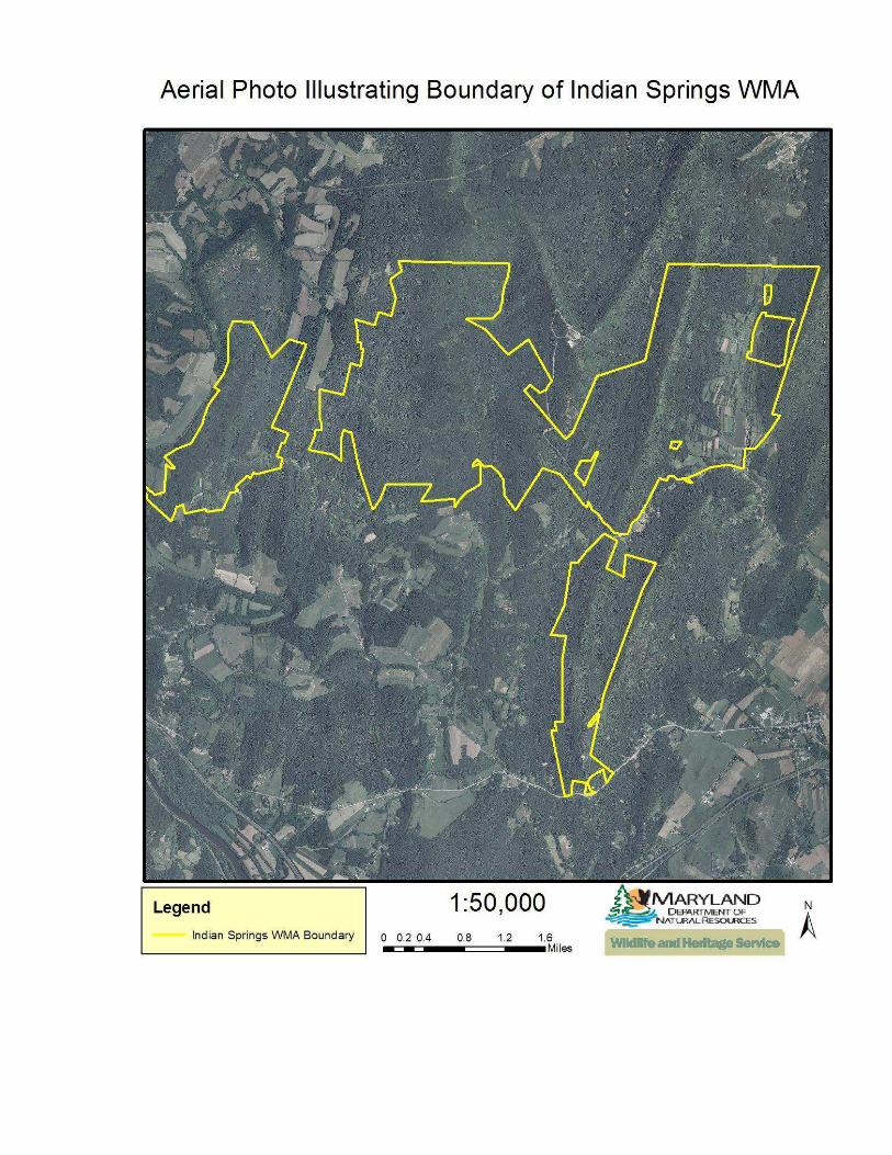
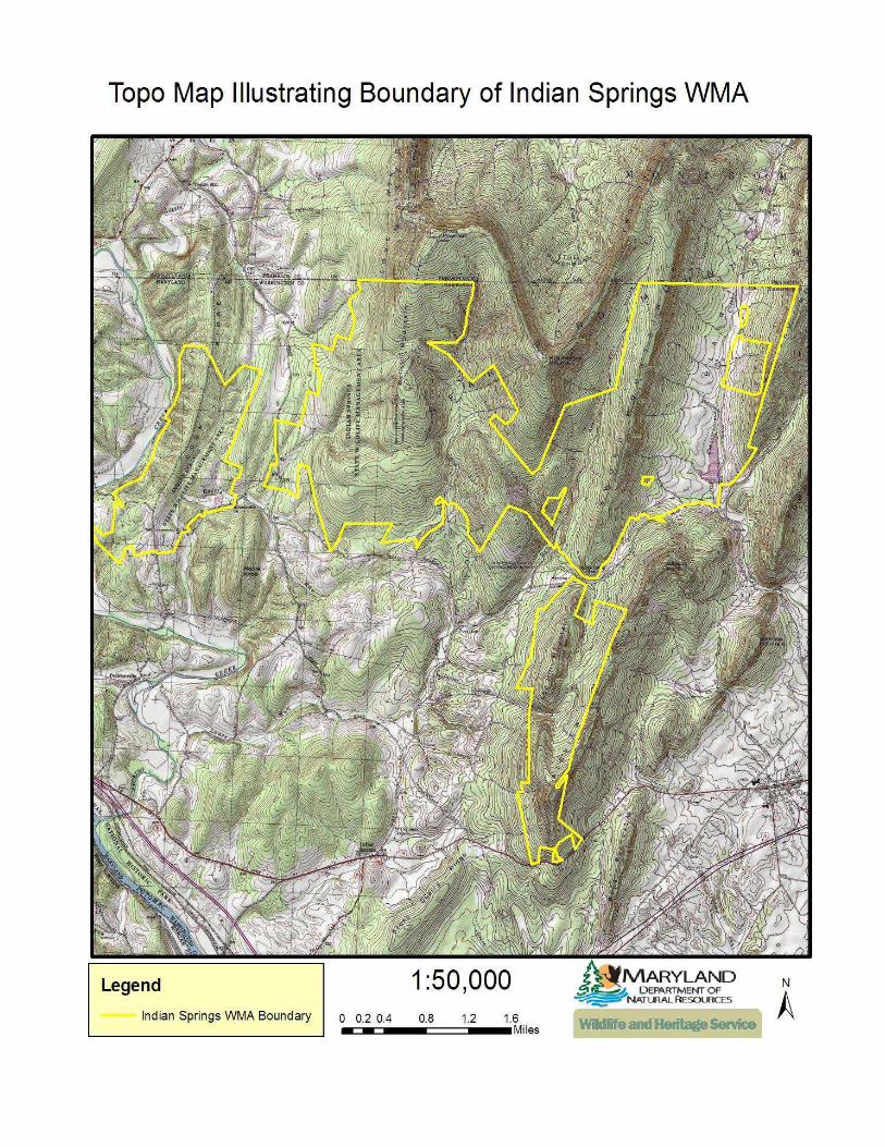

Aerial Photo of the Kuhns Ridge Tract with Management Units


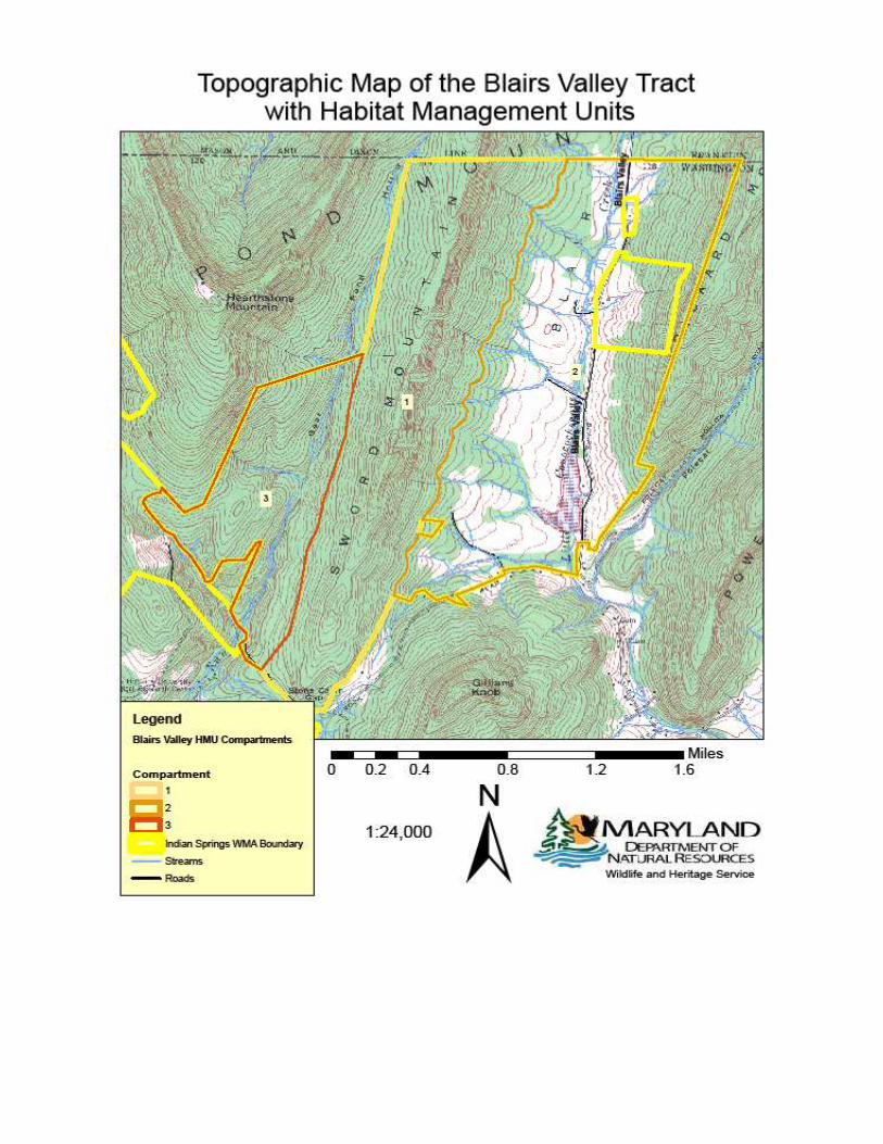

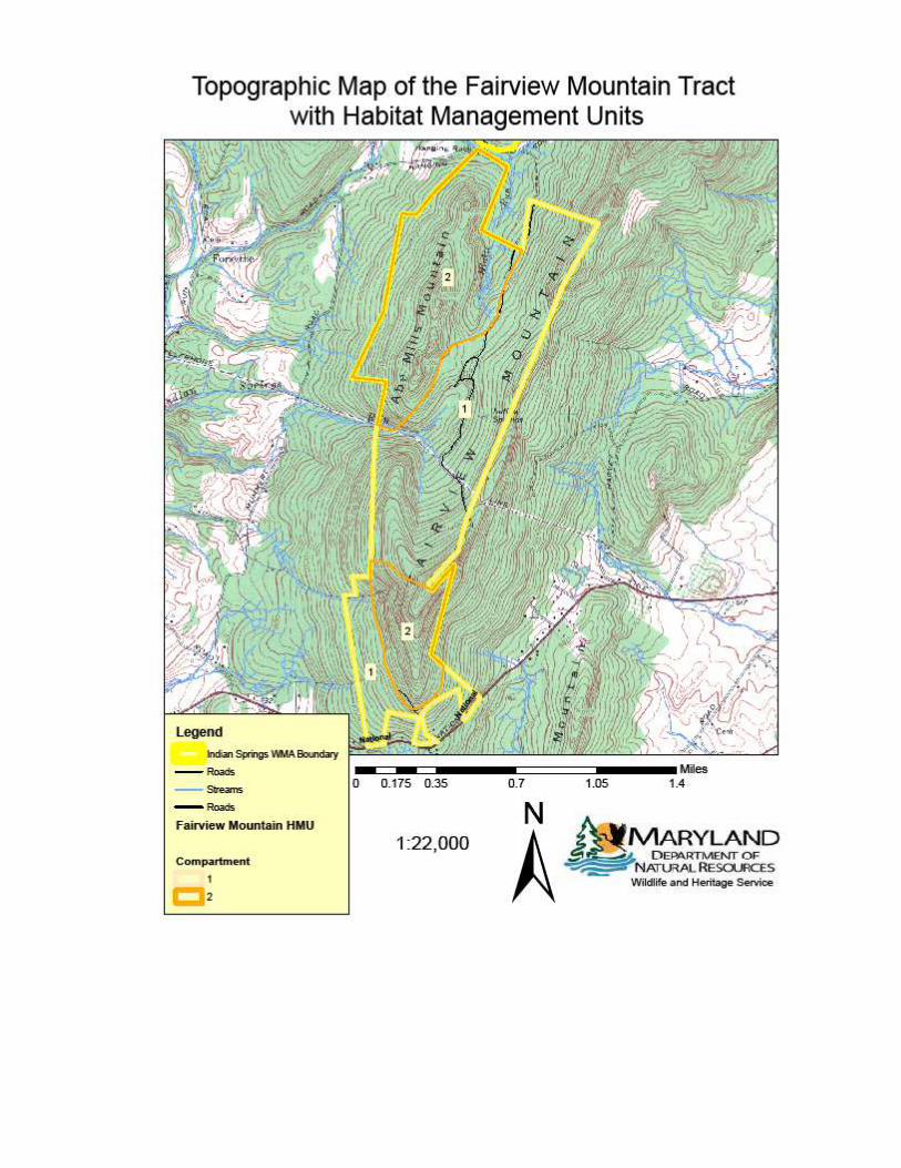

Rare, Threatened, and Endangered Species and Natural Communities found on or
near Indian Springs Wildlife Management Area
Common Name Scientific Name Global
Rank1
State
Rank2
State
Status3
Federal
Status3
PLANTS
Striped gentian Gentiana villosa G5 S1 E
Sharp-scaled mannagrass Glyceria acutiflora G5 S1 E
Butternut Juglans cinerea G4 S2S3
Lowland loosestrife Lysimachia hybrida G5 S2 T
Illinois pondweed Potamogeton illinoensis G5 S1
Northeastern bulrush Scirpus ancistrochaetus G3 S1 E E
Pale mannagrass Torreyochloa pallida G5 S3
Rusty woodsia Woodsia ilvensis G5 S1 T
ANIMALS
Brook floater Alasmidonta varicosa G3 S1 E
Jefferson salamander Ambystoma jeffersonianum G4 S3
Northern barrens tiger beetle Cicindela patruela G3 S1 E
Common raven Corvus corax G5 S3
Timber rattlesnake Crotalus horridus G4 S3
Porcupine Erethizon dorsatum G5 S3 I
Appalachian spring snail Fontigens bottimeri G2 S2
Green floater Lasmigona subviridis G3 S1 E
Small-footed bat Myotis leibii G1G3 S1 E
Little brown bat Myotis lucifugus G3 S1 *
Northern long-eared bat Myotis septentrionalis G2G3 S1 * *
Allegheny woodrat Neotoma magister G3G4 S1 E
Creeper Strophitus undulatus G5 S2 I
Gray petaltail Tachopteryx thoreyi G4 S3
Golden-winged warbler Vermivora chrysoptera G4 S3
Rare Natural Communities and Other Habitats of Conservation Concern
Eastern Hemlock-Hardwood Forest (S3): Forests dominated by eastern hemlock (Tsuga
canadensis), occupying mesic, sheltered habitats throughout the mountains and
isolated, north-facing river bluffs and ravines of the Piedmont and Coastal Plain.
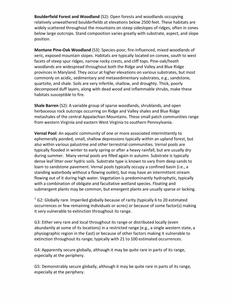
Boulderfield Forest and Woodland (S2): Open forests and woodlands occupying
relatively unweathered boulderfields at elevations below 2500 feet. These habitats are
widely scattered throughout the mountains on steep sideslopes of ridges, often in zones
below large outcrops. Stand composition varies greatly with substrate, aspect, and slope
position.
Montane Pine-Oak Woodland (S3): Species-poor, fire-influenced, mixed woodlands of
xeric, exposed mountain slopes. Habitats are typically located on convex, south to west
facets of steep spur ridges, narrow rocky crests, and cliff tops. Pine-oak/heath
woodlands are widespread throughout both the Ridge and Valley and Blue Ridge
provinces in Maryland. They occur at higher elevations on various substrates, but most
commonly on acidic, sedimentary and metasedimentary substrates, e.g., sandstone,
quartzite, and shale. Soils are very infertile, shallow, and droughty. Thick, poorly
decomposed duff layers, along with dead wood and inflammable shrubs, make these
habitats susceptible to fire.
Shale Barren (S2): A variable group of sparse woodlands, shrublands, and open
herbaceous rock outcrops occurring on Ridge and Valley shales and Blue Ridge
metashales of the central Appalachian Mountains. These small patch communities range
from western Virginia and eastern West Virginia to southern Pennsylvania.
Vernal Pool: An aquatic community of one or more associated intermittently to
ephemerally ponded, small, shallow depressions typically within an upland forest, but
also within various palustrine and other terrestrial communities. Vernal pools are
typically flooded in winter to early spring or after a heavy rainfall, but are usually dry
during summer. Many vernal pools are filled again in autumn. Substrate is typically
dense leaf litter over hydric soils. Substrate type is known to vary from deep sands to
loam to sandstone pavement. Vernal pools typically occupy a confined basin (i.e., a
standing waterbody without a flowing outlet), but may have an intermittent stream
flowing out of it during high water. Vegetation is predominantly hydrophytic, typically
with a combination of obligate and facultative wetland species. Floating and
submergent plants may be common, but emergent plants are usually sparse or lacking.
1 G2: Globally rare. Imperiled globally because of rarity (typically 6 to 20 estimated
occurrences or few remaining individuals or acres) or because of some factor(s) making
it very vulnerable to extinction throughout its range.
G3: Either very rare and local throughout its range or distributed locally (even
abundantly at some of its locations) in a restricted range (e.g., a single western state, a
physiographic region in the East) or because of other factors making it vulnerable to
extinction throughout its range; typically with 21 to 100 estimated occurrences.
G4: Apparently secure globally, although it may be quite rare in parts of its range,
especially at the periphery.
G5: Demonstrably secure globally, although it may be quite rare in parts of its range,
especially at the periphery.

2 S1: Highly state rare- critically imperiled because of extreme rarity (generally 1-5
extant populations or sites) or because of some factor(s) making it especially vulnerable
to extirpation.
S2: State rare- imperiled in Maryland because of rarity (generally 6-20 extant
populations or sites) or because of some factor(s) making it vulnerable to potential
extirpation.
S3: Vulnerable- rare to uncommon (generally 20-100 extant populations or sites).
3E: endangered; T: threatened; I: In Need of Conservation; *: under consideration for
listing
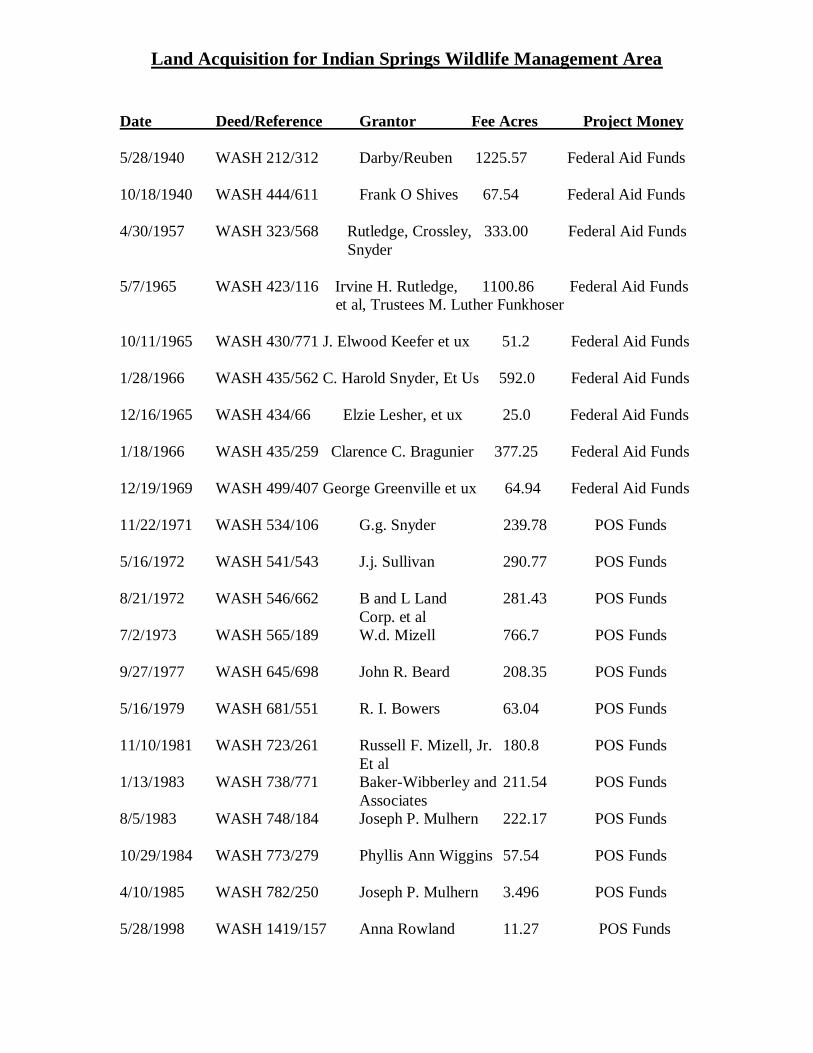
Land Acquisition for Indian Springs Wildlife Management Area
Date Deed/Reference Grantor Fee Acres Project Money
5/28/1940 WASH 212/312 Darby/Reuben 1225.57 Federal Aid Funds 10/18/1940 WASH 444/611 Frank O Shives 67.54 Federal Aid Funds 4/30/1957 WASH 323/568 Rutledge, Crossley, 333.00 Federal Aid Funds Snyder 5/7/1965 WASH 423/116 Irvine H. Rutledge, 1100.86 Federal Aid Funds et al, Trustees M. Luther Funkhoser 10/11/1965 WASH 430/771 J. Elwood Keefer et ux 51.2 Federal Aid Funds 1/28/1966 WASH 435/562 C. Harold Snyder, Et Us 592.0 Federal Aid Funds 12/16/1965 WASH 434/66 Elzie Lesher, et ux 25.0 Federal Aid Funds 1/18/1966 WASH 435/259 Clarence C. Bragunier 377.25 Federal Aid Funds 12/19/1969 WASH 499/407 George Greenville et ux 64.94 Federal Aid Funds 11/22/1971 WASH 534/106 G.g. Snyder 239.78 POS Funds 5/16/1972 WASH 541/543 J.j. Sullivan 290.77 POS Funds 8/21/1972 WASH 546/662 B and L Land 281.43 POS Funds Corp. et al 7/2/1973 WASH 565/189 W.d. Mizell 766.7 POS Funds 9/27/1977 WASH 645/698 John R. Beard 208.35 POS Funds 5/16/1979 WASH 681/551 R. I. Bowers 63.04 POS Funds 11/10/1981 WASH 723/261 Russell F. Mizell, Jr. 180.8 POS Funds Et al 1/13/1983 WASH 738/771 Baker-Wibberley and 211.54 POS Funds Associates 8/5/1983 WASH 748/184 Joseph P. Mulhern 222.17 POS Funds 10/29/1984 WASH 773/279 Phyllis Ann Wiggins 57.54 POS Funds 4/10/1985 WASH 782/250 Joseph P. Mulhern 3.496 POS Funds 5/28/1998 WASH 1419/157 Anna Rowland 11.27 POS Funds

5/28/1998 WASH 1419/157 Anna Rowland -10.93 Land Trade for Above 2/16/2001 WASH 1630/671 Sunny G. Bowers & 151.817 POS Funds Donna Bowers 1/18/2009 WASH 3602/468 Silias and Jennifer Phillips 61.57 POS Funds Program Open Space (POS)