Embed Size (px)
Citation preview
WILTON WEST PRECINCT
REZONING PLANNING PROPOSAL
January 2017
in association with
WILTON WEST PRECINCT
REZONING PLANNING PROPOSAL
JANUARY 2017
Prepared for: Bradcorp Holdings Pty Ltd
Prepared by: Design+Planning
Suite 801, 171 Clarence Street
PO Box 1778
SYDNEY NSW 2000
P: (02) 9290 3636 E: [email protected]
Document Status
VERSION COMMENT PREPARED
BY
REVIEWED
BY
REVIEW DATE APPROVED
BY
ISSUE DATE
1 First Draft GE NM 10/10/2016 NM 10/10/2016
2 Final MR NM 18/01/2017 NM 18/01/2017
Disclaimer and Copyright
This document was commissioned by and prepared for the exclusive use of Bradcorp Holdings Pty Ltd. It is subject to and issued in accordance with the agreement
between Bradcorp Holdings Pty Ltd and DP (Aus) Pty Ltd.
DP (Aus) Pty Ltd acts in all professional matters as a faithful advisor to its clients and exercises all reasonable skill and care in the provision of professional services.
The information presented herein has been compiled from a number of sources using a variety of methods. Except where expressly stated, DP (Aus) Pty Ltd does
not attempt to verify the accuracy, validity or comprehensiveness of this document, or the misapplication or misinterpretation by third parties of its contents.
This document cannot be copied or reproduced in whole or part for any purpose without the prior written consent of DP (Aus) Pty Ltd.
CONTENTS
EXECUTIVE SUMMARY
1 INTRODUCTION ................................................................................................................................................. 1
2 SITE & LOCATION .............................................................................................................................................. 2
2.1 Subject Land ................................................................................................................................................... 2 2.2 Regional Location ............................................................................................................................................ 3 2.3 Site Description and Context ........................................................................................................................... 5
3 VISION ................................................................................................................................................................ 7
3.1 Wilton West Precinct Plan ............................................................................................................................... 7 3.2 Bradcorp’s Vision............................................................................................................................................. 8 3.3 Garden City Inspired Design Philosophy ....................................................................................................... 10 3.4 Excellence in Design ..................................................................................................................................... 13 3.5 Liveability ....................................................................................................................................................... 14 3.6 Driving Socio-Economic Change in South West Sydney ............................................................................... 15 3.7 Employment .................................................................................................................................................. 17
3.7.1 Employment Strategy ........................................................................................................................ 17 3.7.2 Targeted Employment Uses .............................................................................................................. 18 3.7.3 Lakeside Activity Hub ........................................................................................................................ 19 3.7.4 Phases of Employment ...................................................................................................................... 21
3.8 Education & Training ..................................................................................................................................... 22 3.8.1 Tertiary Education ............................................................................................................................. 22 3.8.2 Schools 23 3.8.3 Vocational Education & Training ........................................................................................................ 24 3.8.4 Child Care .......................................................................................................................................... 24
3.9 Environment and Recreation ......................................................................................................................... 24 3.9.1 Environment ...................................................................................................................................... 24 3.9.2 Recreation and Healthy Living ........................................................................................................... 25
3.10 Benefits for the Future Wilton West Community ............................................................................................ 27
4 STRATEGIC PLANNING CONTEXT .................................................................................................................. 29
4.1 Strategic Planning Overview ......................................................................................................................... 29 4.2 Draft South West District Plan ....................................................................................................................... 29 4.3 A Plan for Growing Sydney ........................................................................................................................... 29 4.4 Greater Macarthur Land Release Investigation ............................................................................................. 30 4.5 Wilton New Town........................................................................................................................................... 33 4.6 Wilton Junction Draft Rezoning, Master-Planning and Site Investigations .................................................... 35
4.6.1 Wilton Junction Draft Rezoning ......................................................................................................... 35 4.6.2 Wilton Junction Master Plan .............................................................................................................. 35 4.6.3 Site Investigations ............................................................................................................................. 37
5 PROPOSAL FOR A NEW COMMUNITY ............................................................................................................ 42
5.1 Wilton West Precinct ..................................................................................................................................... 42 5.2 Site Analysis .................................................................................................................................................. 43 5.3 Urban Structure ............................................................................................................................................. 45 5.4 Design Elements ........................................................................................................................................... 47
5.4.1 Movement and Connectivity .............................................................................................................. 47 5.4.2 Activity Nodes .................................................................................................................................... 49 5.4.3 Local Neighbourhoods ....................................................................................................................... 51 5.4.4 Walking and Cycling .......................................................................................................................... 53 5.4.5 Education and Community................................................................................................................. 53 5.4.6 Open Space and Recreation ............................................................................................................. 55
5.5 Rezoning the Site to Enable Infrastructure Delivery ...................................................................................... 57 5.6 Infrastructure Provision .................................................................................................................................. 57 5.7 Direct Access Ramp ...................................................................................................................................... 58 5.8 Individual Voluntary Planning Agreement ...................................................................................................... 60 5.9 Minimising Infrastructure Risk ....................................................................................................................... 60 5.10 Resolution of Co-existence with Mining ......................................................................................................... 61
1 OBJECTIVES OR INTENDED OUTCOMES ....................................................................................................... 63
1.1 Explanation of Objectives and Intended Outcomes ....................................................................................... 63
2 EXPLANATION OF PROVISIONS ..................................................................................................................... 65
2.1 Proposed Modifications to the Wollondilly LEP 2011 .................................................................................... 65 2.1.1 Introduce R1 General Residential Zone into LEP .............................................................................. 66 2.1.2 Amendments to LEP Text .................................................................................................................. 66 2.1.3 Proposed Mapping for LEP................................................................................................................ 71
3 JUSTIFICATION ................................................................................................................................................ 79
3.1 Section A – Need for the Planning Proposal ................................................................................................. 79 3.2 Section B – Relationship to strategic planning framework ............................................................................. 81 3.3 Section C – Environmental, social and economic impact ............................................................................ 108 3.4 Section D – State and Commonwealth Interests ......................................................................................... 110
4 COMMUNITY CONSULTATION ...................................................................................................................... 113
5 PROJECT TIMELINE....................................................................................................................................... 114
6 CONCLUSION ................................................................................................................................................ 115
APPENDICES
Appendix 1 “Wilton Lakeside Precinct: Employment Strategy and Economic Masterplan” dated
December 2016 by MacroPlan Dimasi
Appendix 2 Letter from Minister for Planning dated 1 November 2013
Appendix 3 Wilton Junction Precinct State Environmental Planning Policy Study Requirements
dated 2 May 2013
Appendix 4 Summary of Department of Planning & Environment Response to Wilton Junction
Studies dated August 2016
Appendix 5 Summary of Wilton Junction Report Findings
Appendix 6 Letter from Roads & Maritime Services dated 6 May 2016
Appendix 7 Letter from NSW EPA dated 6 December 2013
P a g e | i
EXECUTIVE SUMMARY
Bradcorp Holdings Pty Ltd (the proponent) are progressing a rezoning proposal for their entire Wilton West landholding within the
recently declared Priority Growth Area of Wilton New Town in South West Sydney. The project is of a sufficiently significant scale to
enable commitments to be made for the early delivery of jobs, new homes for 5,400 families of all types, immediate lifestyle benefits
and the delivery of State significant infrastructure to support the Wilton West project, which is the largest single contributor to the
Government’s proposed Wilton New Town.
Bradcorp are experienced developers with a proven track record in creating highly desirable new communities in South West Sydney.
Wilton West is no exception and Bradcorp has assembled a specialist team with extensive experience in urban design and planning
(Design+Planning) and employment and economics strategy (MacroPlan Dimasi) to ensure Wilton West is a highly successful place
where people aspire to live. Bradcorp and this specialist team are taking an innovative approach in how to build a new, self-contained
community.
Thoughtful and progressive planning and strategy is being undertaken to ensure that the community has wide-ranging benefits and
opportunities from day one of people moving into their new homes. Access to local jobs, schools and post-school training, shopping
and services, and places that enhance their quality of life, especially with the vast natural features within the site, are to be provided
in the earliest stages of the development.
Wilton West is to ‘raise the bar’ in building a new community that encourages people from all ages, household types, levels of academic
achievement and socio-economic status to create a place that is a unique, identifiable, and a highly desirable and attractive place to
live. The natural bushland setting and rivers with the establishment of impressive water bodies are important elements to the character
of Wilton West and making it a special place where people aspire to live.
The Wilton West site forms a significant part of the Wilton Junction rezoning proposal previously submitted to the NSW Government,
encompassing over 16,000 new dwellings, with a project value of over $7 billion (October 2015).
Wilton West now forms part of the Wilton Priority Growth Area, a major new land release precinct in South West Sydney, which is
estimated to encompass delivery of housing, commercial, retail and infrastructure projects worth over $10 billion (Barangaroo - $6.6
billion). Wilton West, as the major land holding is estimated to have a project value of over $3.5 billion.
Wilton West is one of the largest land development projects in Sydney with a single landowner. It has capacity to deliver a self-
contained community with around 5,400 new homes, approximately 16,000 people and 5,500 jobs (greater than the one job per
household target).
Development of the site also requires significant investment in State and Local infrastructure to support the new community, and
Bradcorp is committed to ensure infrastructure is in place early. Bradcorp is able to underwrite the significant upfront cost for
infrastructure due to the scale of the project, which can only be fulfilled with the whole site being rezoned.
Rezoning Wilton West will enable the following:
a lakeside activity hub that contains cafes, health facilities, restaurants, ‘smart’ workplaces, shops, recreation and
entertainment uses.
an 11 hectare man-made waterbody which forms part of an integrated wastewater treatment cycle and is endorsed in
principle by the EPA, that is surrounded with parks and pathways and suitable for some water sports.
5,500 new local jobs with a special focus towards the ‘knowledge & professional services’ and ‘health & education’ sectors.
eight walkable neighbourhoods with a diverse range of housing types and living experiences suited to a variety of families
and households.
around 5,400 new dwellings (including terrace houses) to assist expanding Sydney’s housing supply.
major State infrastructure to make Wilton New Town highly accessible to the regional road network.
new schools and educational facilities to support local learning and employment.
P a g e | ii
a green grid of local parks, active sports fields and boulevards that link to the surround native bushland, encompassing over
47 hectares of open space.
22 km of walking and cycle paths throughout the project.
a blue grid of man-made and natural water features that connect to the Nepean River.
conservation of around 330 hectares of native bushland and waterways.
bush trails and activities that connect people with nature.
Purpose
This Planning Proposal provides the justification and explanation to progress an amendment to Wollondilly Local Environmental Plan
2011 for the whole of Wilton West facilitated through State Environmental Planning Policy (Sydney Growth Centres) 2006.
The objective of this Planning Proposal is:
To amend the Wollondilly Local Environmental Plan 2011 to enable urban development of rural land to create a
new self-contained community comprising business activities, neighbourhood centres, private and public schools,
a range of residential housing (detached housing, the ‘missing middle’ and apartments), sporting facilities and local
parks, major infrastructure, and the conservation of a substantial area of existing natural bushland.
To achieve the outcomes of the Planning Proposal objective, land will need to be rezoned from rural purposes to the following zones:
R1 General Residential
B4 Mixed Use
B5 Business Development
SP2 Infrastructure
There are also amendments to clauses and maps to achieve the objective to create Wilton West.
This Planning Proposal is structured in two parts.
Part 1 outlines the site and land details, as well as details Bradcorp’s vision, design philosophy, and socio-economic and
employment strategies for Wilton West.
Part 2 is the statutory response to amend Wollondilly Local Environmental Plan 2011 and includes the required information in
accordance with the Department of Planning & Environment’s Guidelines for preparing a Planning Proposal.
Bradcorp’s Vision for Wilton West
Bradcorp’s Vision
For over 20 years Bradcorp has built communities that truly make a difference – with a core commitment to create unique living
environments that are of enduring value to the community. Bradcorp believes strongly in reinvesting into Sydney’s southwest
communities to bring about positive change and to set new standards in amenity and lifestyle.
Philosophical Case
Bradcorp’s Wilton Development Project commenced 17 years ago and comprised over 1,320 hectares of land. The neighbouring
master-planned development, Bingara Gorge, has become a benchmark community that has helped attract professionals to live and
work in the region, and as envisaged, is the successful pilot project for Wilton New Town.
P a g e | iii
Wilton West is based on the garden city concept of the English visionary, Sir Ebenezer Howard. Garden cities are planned, self-
contained communities combining the best features of country towns combined with the facilities, services and technologies found
vibrant city centres.
Following the 1970’s Macarthur Three Cities policy, the initial concept for Wilton was to create a more diverse range of housing and
employment choice for Sydney’s southwest to service and attract the growing level of professional employment.
The foundation for the town relies on the “Garden City” being the central focus and integrated whole with its associated environmental,
social, cultural and economic fabric. These fundamental principles are embedded throughout to enable a new town that residents
identify as their place of being. One that they are proud to call their home.
Vision
The vision for Wilton West, being a substantial area of Wilton new town, has built on the vision established for the Wilton Junction
New Town. The vision for Wilton West is:
Located in a unique natural setting characterised by bushland, rivers, creeks, lakes and ridges, Wilton West sits in front of
the Razorback Ranges and contained within the gorges of the Nepean River. The undulating terrain provides the
opportunities for views of the surrounding landscape, with the high points of the Property achieving an ‘amphitheatre’ style
vista over the site.
The proposed master plan for Wilton West has been designed to provide for a new, vibrant and sustainable master planned
community incorporating a series of thoughtfully planned villages with high local amenity, job opportunities and connections
to essential facilities. Wilton West will offer living options to suit a diverse array people, expected to comprise first home
buyers, managers and professionals, families seeking to upgrade, even down-sizers.
The neighbouring master-planned development, Bingara Gorge, is the successful pilot project for Wilton New Town. Bradcorp’s
delivery of Wilton West, as a whole town, will reflect the Federal and State government policies and initiatives that have evolved since
the 1970s.
Wilton West is based on core principles, such as:
A holistic Rural/Urban amenity – offering the best of both the country and city lifestyle.
Healthy communities through a variety of education and health facilities.
Intelligence and connection through advanced technology and infrastructure.
Innovation for employment self-containment and opportunities.
Environmental sustainability to maintain and protect the rural features synonymous with the surrounds.
Housing diversity to suit a range of home buyers.
Garden City Principles
The key principles that underpin the design are summarised as follows:
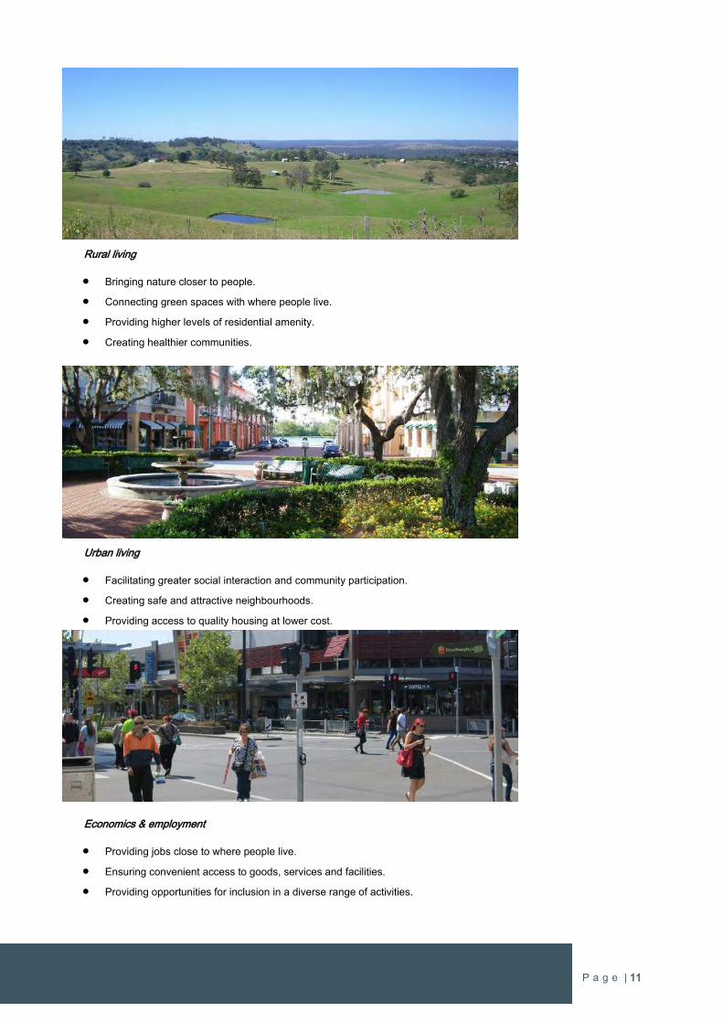
Rural living
Bringing nature closer to people.
Connecting green spaces with where people live.
Providing higher levels of residential amenity.
Creating healthier communities.
P a g e | iv
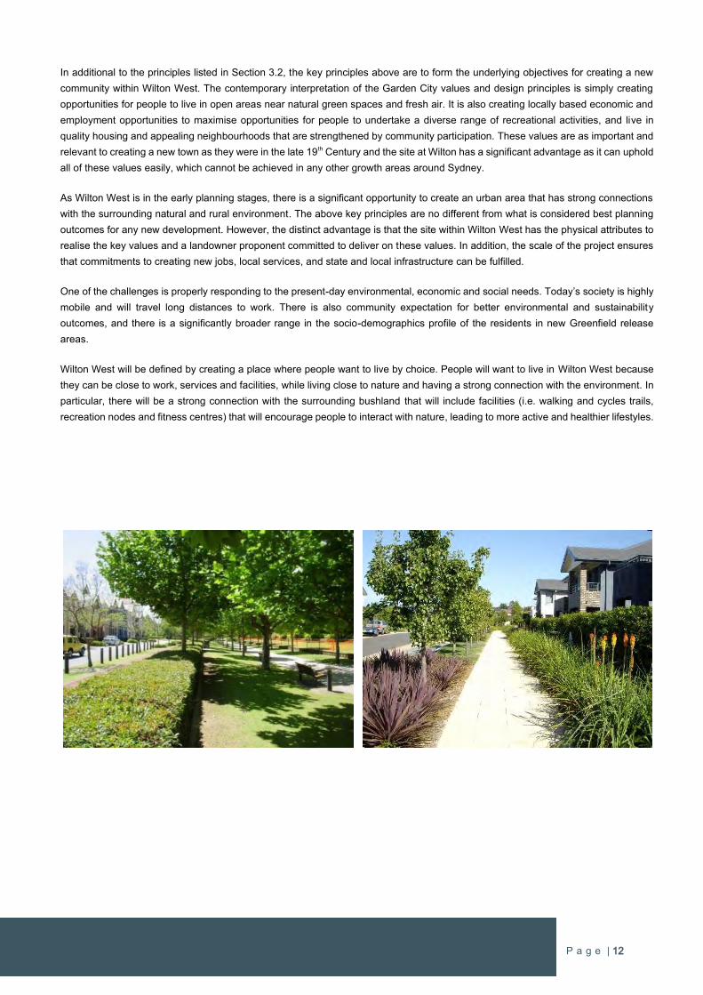
Urban living
Facilitating greater social interaction and community participation.
Creating safe and attractive neighbourhoods.
Providing access to quality housing at lower cost.
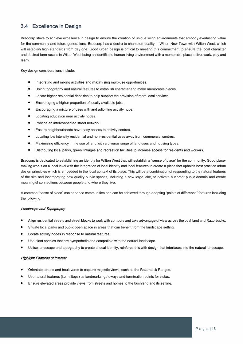
Economics & employment
Providing jobs close to where people live.
Ensuring convenient access to goods, services and facilities.
Providing opportunities for inclusion in a diverse range of activities and occupations.
The principles are similar to Ebenezer Howard’s Garden City version but embody current economic and social realities, and are
consistent with a more polycentric urban form.
Strategic Planning
The NSW Government adopted legislation to create the Greater Sydney Commission in the beginning of 2016. The Greater Sydney
Commission is empowered to “lead and guide the planning for development, transport and housing so that Greater Sydney will be a
productive, liveable and sustainable city for all.”.
The Greater Sydney Commission released six Draft District Plans for Greater Sydney for public review and comment on 21 November
2016. Wilton West is within the Draft South West District Plan which includes the future Western Sydney Airport and the future third
‘aerotropolis’ city of Sydney known as “Western City”.
The Draft South West District Plan sets out the vision, priorities (productivity, sustainability and liveability) and actions for the
development of the South West District. The District Priorities set the criteria for assessing how any proposal meets the requirements
of the District Plan and therefore the NSW Government’s planning objectives
All planning proposals are required to demonstrate how they satisfy the priorities where relevant. The scale and location of Wilton
West (within the Wilton Priority Growth Area) means that all District Priorities have some relevance to this Planning Proposal. This
Proposal achieves the priorities of the Draft South West District Plan which is demonstrated in a detailed response to all Productivity,
Liveability and Sustainability Priorities in Part B of this proposal.
The Greater Sydney Commission is concurrently reviewing the metropolitan strategy for Sydney title “A Plan for Growing Sydney”,
which was published in December 2014. This Plan identified approximately 17,600 hectares of land for investigation known as The
Greater Macarthur Investigation Area which includes Wilton and the subject site.
In September 2015 the NSW Government released the Greater Macarthur Land Release Investigation which identified two potential
Priority Growth Areas; including Wilton. In June 2016 the Department of Planning & Environment released a consultation update
which sets out a number of modifications to Greater Macarthur Land Release Investigation. The most significant modification was the
identification of Wilton New Town for immediate action with the delivery of homes forecast to have people moving into their homes in
late 2018. The Minister for Planning declared the Wilton Priority Growth Area on 29 July 2016. The Priority Growth Area is formalised
through an amendment to the State Environmental Planning Policy (Sydney Region Growth Centres) 2006.
P a g e | v
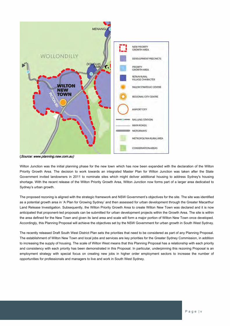
(Source: www.planning.nsw.com.au)
Wilton Junction was the initial planning phase for the new town which has now been expanded with the declaration of the Wilton
Priority Growth Area. The decision to work towards an integrated Master Plan for Wilton Junction was taken after the State
Government invited landowners in 2011 to nominate sites which might deliver additional housing to address Sydney's housing
shortage. With the recent release of the Wilton Priority Growth Area, Wilton Junction now forms part of a larger area dedicated to
Sydney’s urban growth.
The proposed rezoning is aligned with the strategic framework and NSW Government’s objectives for the site. The site was identified
as a potential growth area in ‘A Plan for Growing Sydney’ and then assessed for urban development through the Greater Macarthur
Land Release Investigation. Subsequently, the Wilton Priority Growth Area to create Wilton New Town was declared and it is now
anticipated that proponent-led proposals can be submitted for urban development projects within the Growth Area. The site is within
the area defined for the New Town and given its land area and scale will form a major portion of Wilton New Town once developed.
Accordingly, this Planning Proposal will achieve the objectives set by the NSW Government for urban growth in South West Sydney.
The recently released Draft South West District Plan sets the priorities that need to be considered as part of any Planning Proposal.
The establishment of Wilton New Town and local jobs and services are key priorities for the Greater Sydney Commission, in addition
to increasing the supply of housing. The scale of Wilton West means that this Planning Proposal has a relationship with each priority
and consistency with each priority has been demonstrated in this Proposal. In particular, underpinning this rezoning Proposal is an
employment strategy with special focus on creating new jobs in higher order employment sectors to increase the number of
opportunities for professionals and managers to live and work in South West Sydney.
P a g e | vi
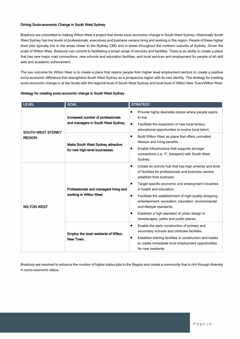
Driving Socio-economic Change in South West Sydney
Bradcorp are committed to making Wilton West a project that drives socio-economic change in South West Sydney. Historically South
West Sydney has low levels of professionals, executives and business owners living and working in the region. People of these higher
level jobs typically live in the areas closer to the Sydney CBD and in areas throughout the northern suburbs of Sydney. Given the
scale of Wilton West, Bradcorp can commit to facilitating a broad range of services and facilities. There is an ability to create a place
that has new major road connections, new schools and education facilities, and local services and employment for people of al l skill
sets and academic achievement.
The key outcome for Wilton West is to create a place that retains people from higher level employment sectors to create a positive
socio-economic difference that strengthens South West Sydney as a prosperous region with its own identity. The strategy for creating
socio-economic change is at two levels with the regional level of South West Sydney and local level of Wilton New Town/Wilton West.
Strategy for creating socio-economic change in South West Sydney
LEVEL GOAL STRATEGY
SOUTH WEST SYDNEY
REGION
Increased number of professionals
and managers in South West Sydney.
Provide highly desirable places where people aspire
to live.
Facilitate the expansion of new local tertiary
educational opportunities to evolve local talent.
Make South West Sydney attractive
for new high-level businesses.
Build Wilton West as place that offers unrivalled
lifestyle and living benefits.
Enable infrastructure that supports stronger
connections (i.e. IT, transport) with South West
Sydney.
WILTON WEST
Professionals and managers living and
working in Wilton West.
Create an activity hub that has high amenity and level
of facilities for professionals and business owners
establish their business.
Target specific economic and employment industries
in health and education.
Facilitate the establishment of high-quality shopping,
entertainment, recreation, education, environmental
and lifestyle standards.
Establish a high standard of urban design in
streetscapes, parks and public places.
Employ the local residents of Wilton
New Town.
Enable the early construction of primary and
secondary schools and childcare facilities.
Establish training facilities in construction and trades
to create immediate local employment opportunities
for new residents.
Bradcorp are resolved to enhance the number of higher status jobs in the Region and create a community that is rich through diversity
in socio-economic status.
P a g e | vii
Economic, Employment and Housing Trends and Observations
South West Sydney has been experiencing strong urban growth for new housing and employment land for the last 10 years and very
strong growth within the last 5 years. The NSW Government has delivered major infrastructure projects in road and rail and there are
many more infrastructure projects in construction or planning and design stages. The biggest game-changing infrastructure item for
Western Sydney will be the Western Sydney Airport. The airport is scheduled to be operational in the mid-2020s and will eventually
provide over 60,000 direct jobs. There is also a major roads program to facilitate transport to the airport and throughout Western
Sydney which has been valued at $3.6 Billion.
South West Sydney is receiving many benefits of the NSW Government’s infrastructure program with the completion of the new rail
line to the future Leppington Regional Centre and upgrades to Camden Valley Way. The Northern Road and Bringelly Road are
current being constructed, and there is now greater focus to the infrastructure requirements in the Greater Macarthur area. South
West Sydney is an area of significant investment by the NSW Government which is being complemented by significant investment by
the land development and construction industries.
MacroPlan Dimasi has identified some key trends and observations in economics, employment and housing which include:
Economic:
Sydney’s economic growth is healthy, with the continued investment by state government on the infrastructure program
expected to continue, this will drive the economy once the pace of the dwelling construction (apartment) moderates.
A shortage of housing still exists in Sydney, even with the increased production of residential construction. Strong population
growth and low interest rates are continuing to support demand. The continued camping out for new lots is indicative of the
need for a more competitive range of development fronts and land supply.
The rise in house prices is providing continued support for consumer spending.
Services tied to consumer spending are benefiting from this economic environment – health, professional, retail, food and
accommodation.
A lower Australian dollar and positive conditions in the retail sector and labour market provide an encouraging outlook for
continued investment.
Employment:
Sydney and South West Sydney have continued to average annual jobs growth close to 1.5% over the past 5 years.
Jobs and household growth will continue to be supported from the broader construction cycle.
Population growth across the South West will continue to be a major facilitator for employment growth.
Major Infrastructure investment (road, rail, airport) and expansion in transport and the logistics industry will be a major factor
of growth.
As the local economy matures health, education, professional services will experience strong demand.
The delivery of the whole corridor will continue to drive industry expansion and supply chain growth across the region.
Remote and mobile workers will continue to be attracted given the geographic access with increased infrastructure delivery
(WSEA, Badgerys Creek, Illawarra etc).
Housing:
Residential construction has been the catalyst for the strong population growth.
The shifts in the residential property market, as well as jobs growth and economic stimulus supports the rise in demand for
new housing.
Regional population growth is being driven by diversity in the demographic sub markets – this includes first home buyers
(25-39) to persons aged 65+.
P a g e | viii
Primary shifts towards smaller lot housing within newer residential estates in the south west is attracting primary shifts in
demand.
Many older age groups and mature families can downsize or cash out due to the recent growth in the value of residential
property, and this is driving a demand for a wider range of housing options such as over 55 lifestyle villages or resort parks.
Employment & Economics
Bradcorp is committed to establishing early and targeted economic and employment growth to support local jobs and services for
Wilton West from day one.
Wilton West can deliver greater results than the targets of the Wollondilly Shire Council and the NSW Government to ensure
sustainable employment of “one job per dwelling” in Wilton New Town throughout the delivery lifecycle of the project. This is achieved
by economic development plans and proactively targeting the key growth drivers for each phase and setting targets for new jobs
which are implemented in phases. Economic specialists MacroPlan Dimasi has prepared an Employment Strategy comprising an
economic plan and targeted employment strategy to guide the early establishment of local services and jobs for future residents and
the ongoing creation of new jobs throughout the growth of Wilton New Town (refer to “Wilton Lakeside Precinct: Employment Strategy
& Economic Masterplan” dated December 2016 by MacroPlan Dimasi in Appendix 1).
Whilst Wilton West is to contain two local activity centres with around 5,000m2 of retail uses, the focus of establishing permanent local
jobs in an ‘Activity Hub’ adjacent to a large lake will target jobs in the services sector, which represents around 80 percent of all
employment Australia-wide and is increasing. The services sector is a major generator of employment and with early planning will
form the majority of employment opportunities in Wilton West. It will also ensure that the future Wilton New Town Centre retains its
role as the primary retail centre within Wilton New Town.
The economic plan driving the employment outcomes are:
Meeting existing gaps based on demand e.g. already committed to a K-12 Anglican College.
Trapping construction multipliers locally.
Leveraging the fastest growing economic sectors i.e. health and education.
Attracting small to medium size (SME’s) enterprises and contractors.
Leveraging local amenity (i.e. the lake) to accommodate a wide range of business and recreational cases (e.g. club,
gymnasium) and regional meetings and conferences.
Provision of service retail to service local needs, complementing the regional retail centre will most likely not be feasible for
around 10 years.
Leveraging ingress and egress to the freeway to accommodate a range of regional and sub-regional uses including
emergency services, transport services, home care services etc.
The Lakeside Precinct Economic Plan complements the proposed future Regional Centre and focuses on a range of uses
which vertically integrate by sectors e.g. health.
The economic plan targets key growth drivers to activate the delivery and creation of employment that will grow in a sustained manner
through the lifecycle of the development and beyond. These key land use drivers identified by MacroPlan Dimasi include activities
such as education, health, service retail and small-medium enterprise, and construction. These include the various social infrastructure
requirements outlined in the Social Infrastructure Assessment prepared by Elton Consulting and enclosed with this proposal. It also
builds on Bradcorp’s existing commitment from the Anglican Schools Corporation to establish a new K-12 school in Wilton West.
The type of activities that generate economic activity and jobs will phase in throughout the delivery lifecycle of Wilton West. As
development progresses and the population increases, the critical mass will drive economic activity and establish key land use
activities.
P a g e | ix
MacroPlan Dimasi identified four phases of job development beginning at day one of construction through to the establishment of
Wilton New Town as a regional service centre, which is expected to occur in 2033 (refer to Appendix 1).
The four phases of employment are outlined below.
Phase 1: Construction Employment & Training
The project will be dominated by all aspects of construction related employment including managerial and entrepreneurial
opportunities. To maximise jobs outcomes, activate contract and development management will be required to maximise
the localisation of job multipliers.
Phase 2: Foundation Service Sector Employment
This phase introduces:
Education (Primary & Secondary schools)
Training (VET / Construction and training facility)
Collaboration (small business incubator)
Recreation / place making (club with recreational facilities)
Retail (neighbourhood centre)
Phase 3: Growth
This phase introduces:
Allied health and significant retirement living options as a baseload for growing a regionally significant allied health
industry
Significant employment land
Emergency services
Regional transport + distribution (e.g. bus depot, homecare)
Regional freight and logistics
Expansion to the retail offer
Expansion to the business incubator
Introduction of community services employment
Phase 4: Maturity
This phase accommodates a wide range of centre based and non-centre based contractors and SME’s which can service
the local and regional requirements and provides the basis for a diversified and resilient economy for the Lakeside Precinct.
It positions greater Wilton to grow to a regional service centre level.
The Jobs Cashflow provided by MacroPlan Dimasi demonstrates steady job growth from the beginning of construction. Initially jobs
will form around the construction sector. Once there is a critical mass of residential to support a local services sector, the health and
education sectors will be targeted to create demand for professionals and higher order jobs. There will also be job growth in the retail
and small to medium size enterprises and contractors sectors as well as throughout the first 16 years of the delivery lifecycle.
P a g e | x
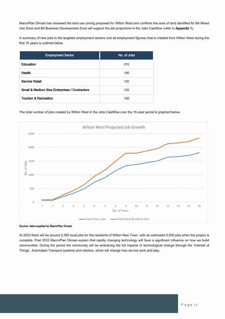
MacroPlan Dimasi has reviewed the land use zoning proposed for Wilton West and confirms the area of land identified for B4 Mixed
Use Zone and B5 Business Development Zone will support the job projections in the Jobs Cashflow (refer to Appendix 1).
A summary of new jobs in the targeted employment sectors (not all employment figures) that is created from Wilton West during the
first 16 years is outlined below.
Employment Sector No. of Jobs
Education 270
Health 190
Service Retail 130
Small & Medium Size Enterprises / Contractors 120
Tourism & Recreation 160
The total number of jobs created by Wilton West in the Jobs Cashflow over the 16-year period is graphed below.
Source: data supplied by MacroPlan Dimasi
At 2033 there will be around 2,350 local jobs for the residents of Wilton New Town, with an estimated 5,500 jobs when the project is
complete. Post 2033 MacroPlan Dimasi explain that rapidly changing technology will have a significant influence on how we build
communities. During the period the community will be embracing the full impacts of technological change through the ‘Internet of
Things’, Automated Transport systems and robotics, which will change how we live work and play.
P a g e | xi
Education
Education and learning facilities are key elements to building a new community for Wilton New Town. Wilton West will provide the full
range of education opportunities from early childhood learning to schooling and then up to higher level tertiary education.
Bradcorp’s commitment to education is demonstrated through agreements with providers for new schools at Wilton West already in
place, and Bradcorp has already provided the land for the existing public school in Bingara Gorge. Bradcorp has an agreement with
the Sydney Anglican Schools Corporation to establish a new Kindergarten to Year 12 school as part of the early stages of
development. The School has been given the title of “Wollondilly Anglican College – Lakeside Campus” and will provide state-of-the-
art learning facilities for its future students. The key benefit is the assurance that Wilton New Town will have education facilities for
the families that live in the first homes.
The other school proposed for Wilton West is a Public Primary School in the north of the site which will be delivered as required.
Bradcorp is intent on facilitating the opportunities for higher education/university qualifications within Wilton West. Tertiary education
facilities will be targeted through a university level annex offering specialist teaching to support the local services sector and the
promotion of professionals and executive living and working in Wilton West. The university annex will also spread the reach of tertiary
education to bring it closer to other towns within the Wollondilly LGA and the southern highland communities further to the southwest.
The position of Wilton New Town on major road connections to the southern highlands and Wollongong makes Wilton West a highly
suitable place for this type of tertiary education facility.
Onsite training in construction will form an early impetus for localised education opportunities for new residents to learn in the area
where they live and then work where they live. The Employment Strategy promotes the establishment of a dedicated facility to train
in trades and construction skills within Wilton West. It will provide local learning beyond high school with a training facility dedicated
to skilling people in construction and trades including business that equip people who work in the New Town with the needed skills to
take advantage of jobs in the future. This is to educate through apprenticeships and general construction skills in a partnership with
an appropriate educational institution and will start a bright future for the younger residents of Wilton New Town.
Child Care facilities are to be provided in line with the growing new population. New families will be able to choose to grow their
families as well as work within Wilton West and Wilton New Town. Child care centres are to offer a range of activities and programs
to engage the children of Wilton West and start the early education process.
Environment and Recreation
Over 300 hectares of environmentally significant land will be conserved and maintained at Wilton West by the proceeds generated
from urban development. An Environmental Trust is proposed to protect the environment in perpetuity for future generations to enjoy
and provide an opportunity for learning through interaction and interpretation. The environmental lands are significant in size and will
also provide opportunity for recreation and education in a similar approach to the multi-faceted environmental facilities in the Western
Sydney Parklands. The site will also enable broader recreation and education opportunities associated with the Nepean River.
To complement the significant environmental benefit of the Environmental Trust, an innovative treatment of wastewater with the large
lake is proposed as a cornerstone for the development. The lake will have a multitude of direct and indirect benefits, one of the key
environmental benefits is the final treatment of wastewater generated by Wilton New Town. The lake will ensure that treated
wastewater will be discharged back into the environment at a level of quality that significantly exceeds current standards.
The benefits of the large lake and conserved environmental lands plus the local parks and sports fields will create a place that
encourages and supports healthy living. The lake will facilitate a range of active and passive recreational uses including incidental
contact water sports, which are activities not likely to cause immersion in the water (i.e. kayaking, canoeing), and land based activities
that are a direct consequence from the existence of the lake (i.e. promenading, jogging, walking, cycling).
P a g e | xii
A variety of open space areas and recreation spaces are to be incorporated into Wilton West to ensure a diverse range of activities
for everyone to use and enjoy, with over 47 hectares of open space provided within the community. The project will also deliver over
22km of walking and bike trails within the conservation lands, encouraging active healthy living for all future residents.
A network of formal and informal cycling and pedestrian paths in green corridors and waterways provide opportunities for pleasurable
walking and cycling experiences, encouraging recreational uses of the facilities. These pathway connections in the green corridor will
connect with the pathway networks in the roads and neighbourhoods to ensure quality and efficient connections to activity nodes,
high-order recreation features (i.e. district sports fields, lake) and education facilities.
Infrastructure
The Wilton West Precinct is ranked third in size of the Precincts released in the South West Priority Growth Area and is similar in area
to the Edmondson Park Precinct, which provided for around 6,000 new homes and also includes a significant area dedicated to
conservation lands.
The scale of Wilton West and being in single ownership provides greater certainty to underwrite and therefore deliver the essential
infrastructure to support the new community. The Infrastructure Staging Schedule accompanying the rezoning has Bradcorp funding
70 percent of the State infrastructure costs at 23 percent of development. This leaves 30 percent of State infrastructure for the
remaining 77 percent of development, which significantly minimises the risk to Government.
Key infrastructure items include:
Upgrades to Picton Road
New off and on ramps from the Hume Highway
New public and private education facilities
Essential servicing infrastructure (potable water, wastewater and electricity)
New public transport infrastructure
At every stage of the development the funding of State infrastructure is significantly forward of the demand generated by the new
urban growth and this is secured in a legally binding agreement. Therefore, it can be assured that infrastructure delivery and ‘at no
additional cost to Government’ imperatives are met with no risk to Government.
Direct Access Ramp
Major connections Wilton New Town are to be improved with an additional off-ramp from the Hume Highway that provides a direct
access route to the northern urban areas of Bingara Gorge and Wilton West. Direct access establishes a new strategic road connection
directly off the Hume Highway that will reduce traffic on the exiting Hume Highway/Picton Road interchange and increase options for
accessing the broader Wilton New Town.
A concept of the direct access ramp has been presented to the NSW Roads & Maritime Services (RMS) for preliminary review and
subsequently the RMS has advised they have no objection progressing consideration of the concept subject to more detailed
investigations.

P a g e | xiii
In addition to encouraging urban growth, key benefits for the Wilton New Town community include:
More convenient and direct access for the northern portion of Wilton New Town residents from the Hume Highway.
Improved community safety by providing access to Wilton New Town that is not shared with heavy vehicles and the ‘free
flow of freight.
Reduced reliance and traffic volumes on the Hume Highway/Picton Road interchange and the ability to separate local traffic
from Wilton New Town with heavy freight vehicles.
Reduce traffic volumes on Picton Road and Pembroke Parade intersection.
Substantial travel and time savings for existing and future residents within Wilton New Town.
Improved capacity of the Picton Road/Hume Highway interchange and the local road network by better distributing traffic on
the planned Wilton New Town road network.
Site & Location
The Wilton West site incorporates four Land Titles with a total area of approximately 876ha. The site has been used for grazing
purposes and contains large farm paddocks surrounded by native vegetation, sandstone outcrops and major rivers.
The site is located within the South West Region of the Sydney Metropolitan Area in the locality of Wilton and the Local Government
Area of Wollondilly Shire Council. By road the site is 85km south west of the Sydney CBD, 31km northwest of Wollongong and 7km
east of the Picton township. The site is adjacent to the Hume Highway to the southeast and Picton Road to the southwest. The Nepean
River forms the boundary from the north around to the west where the River and Picton Road intersect.
The site is strategically located on the main traffic route between the future West Sydney Airport and Aerotropolis and Port Kembla in
Wollongong. The presents a distinct advantage to establishing a new community that can leverage of the high order activities of these
existing and future activities, in particular employment.
(Map source: Google Maps)
P a g e | 1
PART 1 – THE CASE FOR URBAN DEVELOPMENT
1 INTRODUCTION
This Planning Proposal seeks to rezone land for urban development within the Wollondilly Local Government Area, which includes a
significant amount of land being preserved for environmental protection. The site is known as the Wilton West Precinct and is located
within the Wilton Priority Growth Area, which is to facilitate the establishment of Wilton New Town.
Wilton West Precinct is a proposal for a new community comprising over 16,000 people and is to form part of a larger town that offers
a high level of self-containment, integrating a contemporary urban design within a unique natural and rural setting, and bushland,
rivers and lake. The Precinct comprises over 870 ha of land and will provide a range of living options supported by schools, shops,
services, open space and employment opportunities.
This Planning Proposal is structured in two parts.
Part 1 outlines the site and land details, as well as details Bradcorp’s vision, design philosophy, and socio-economic and
employment strategies for Wilton West.
Part 2 is the statutory response to amend Wollondilly Local Environmental Plan 2011 and includes the required information in
accordance with the Department of Planning & Environment’s Guidelines for preparing a Planning Proposal.
Whilst the proposal is to amend Wollondilly Local Environmental Plan 2011, the rezoning proposal is to be facilitated through an
amendment under the State Environmental Planning Policy (Sydney Region Growth Centres) 2006.
The studies supporting the rezoning have been carried out following receipt of Director General’s Requirements for the creation of a
SEPP over Wilton Junction in May 2013. The Planning Proposal is in line with the NSW Government’s strategic planning framework
for urban growth in South West Sydney, in particular the early planning undertaken for the Greater Macarthur Investigation Area. The
site is also within an area identified for growth in ‘A plan for Growing Sydney’, which is the Government’s Metropolitan growth strategy
for Greater Sydney.
The Planning Proposal will enable development of over 5,400 new homes and will create local businesses and an estimated 5,500
jobs for local residents. An Employment Strategy by MacroPlan Dimasi has been prepared for Wilton West and is included in this
proposal. This Employment Strategy establishes a framework to deliver new employment opportunities over the lifecycle of the
development which are targeted at specific industry centres.
Early in the development employment will be established through construction and supporting businesses such as training. There will
also be early local jobs in education with the Sydney Anglican Schools Corporation committed to build a new kindergarten to year 12
school in Wilton West in the first stages of development.
Local employment opportunities will expand as the local service industries are encouraged to establish in the Lakeside Activity Hub,
in particular in health and supporting industries for the ageing population. Encouraging and facilitating local services sector businesses
and employment (i.e. engineers, architects, doctors) and other types of executives and business professionals enables these people
to work where they live, which is a significant boost liveability. There will also be local businesses to support the daily shopping needs
for the new residents. With a focus on the early delivery of new jobs in step with the growing population, the new urban area will
achieve outstanding results in self-containment as people will be able to work near where they live.
The other key aspect of the Planning Proposal is to zoned land to provide a diverse range of housing options to ensure all types of
families and households can choose to live in Wilton West. This will be achieved by providing a variety of lot sizes and facilitating
various types of residential buildings. It is also intended to provide living options for the ageing population which is to be supported by
dedicated local health services. This will allow multiple generations of a family to live within the same community.

P a g e | 2
The Planning Proposal also seeks to rezone land for large-format business to provide greater diversity in business and employment
opportunities within the project. The ‘employment lands’ will be suitable for establishing a range of businesses. Upfront business will
be able to reliably take advantage of the ripple effect from development and construction related industries. Over time these business
would change to those that service the new population in addition to the broader south west strongly connected region.
As part of the rezoning, there has been comprehensive investigation and planning into the State and local infrastructure needs to
support the future population. This will include the provision of extensive road upgrades, in particular in relation to the Hume Highway/
Picton Road Interchange, new public transport facilitates, new education and recreational facilities, and conservation of
environmentally significant land.
2 SITE & LOCATION
2.1 Subject Land
The Wilton West land subject to this proposal is owned by Bradcorp Holdings Pty Ltd and incorporates four Land Titles with a total
area of approximately 876ha (refer Figure 1). The Land Titles subject to this proposal include:
Bradcorp Holdings P/L:
Lot 1 DP1215383
Lot 2 DP1215383
Lot 4 DP702024
Lot 1 DP629828
Land owned by others, being land subject to proposed SP2 zoning for roadways:
Lot 26 DP270536
Lot 31 DP270536
Lot 13 DP702024
Lot 2 DP253992
Lot 200 DP1195273
Figure 1: Land Subject to the Planning Proposal
P a g e | 3
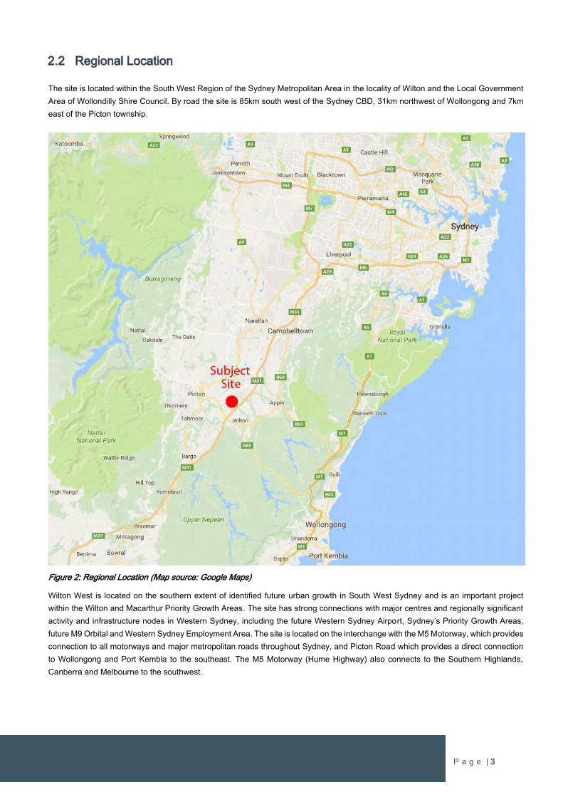
2.2 Regional Location
The site is located within the South West Region of the Sydney Metropolitan Area in the locality of Wilton and the Local Government
Area of Wollondilly Shire Council. By road the site is 85km south west of the Sydney CBD, 31km northwest of Wollongong and 7km
east of the Picton township.
Figure 2: Regional Location (Map source: Google Maps)
Wilton West is located on the southern extent of identified future urban growth in South West Sydney and is an important project
within the Wilton and Macarthur Priority Growth Areas. The site has strong connections with major centres and regionally significant
activity and infrastructure nodes in Western Sydney, including the future Western Sydney Airport, Sydney’s Priority Growth Areas,
future M9 Orbital and Western Sydney Employment Area. The site is located on the interchange with the M5 Motorway, which provides
connection to all motorways and major metropolitan roads throughout Sydney, and Picton Road which provides a direct connection
to Wollongong and Port Kembla to the southeast. The M5 Motorway (Hume Highway) also connects to the Southern Highlands,
Canberra and Melbourne to the southwest.
P a g e | 4
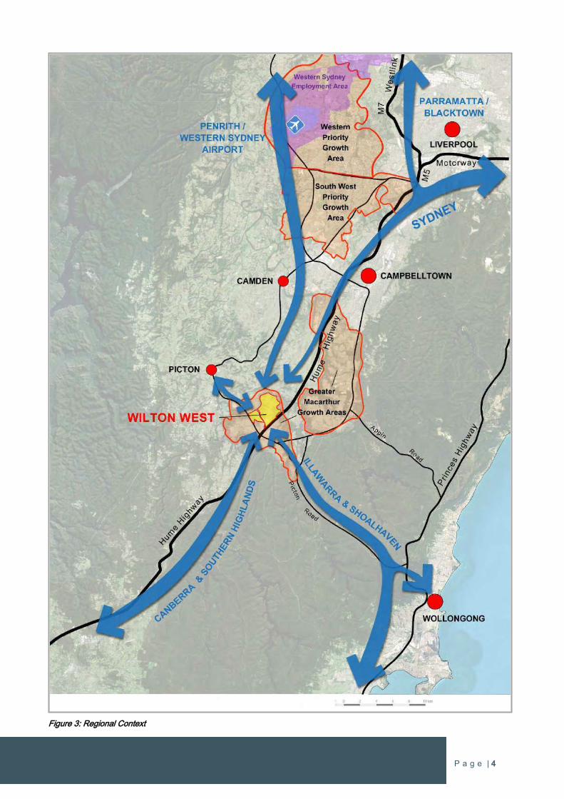
Figure 3: Regional Context
P a g e | 5
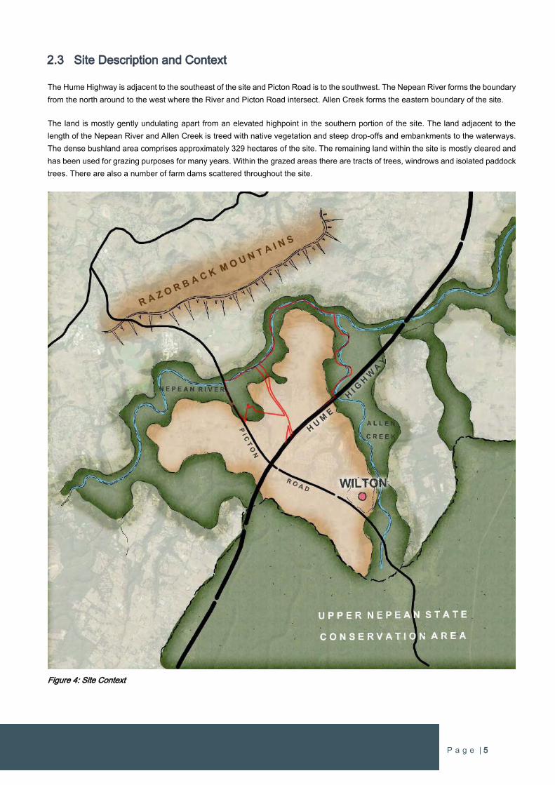
2.3 Site Description and Context
The Hume Highway is adjacent to the southeast of the site and Picton Road is to the southwest. The Nepean River forms the boundary
from the north around to the west where the River and Picton Road intersect. Allen Creek forms the eastern boundary of the site.
The land is mostly gently undulating apart from an elevated highpoint in the southern portion of the site. The land adjacent to the
length of the Nepean River and Allen Creek is treed with native vegetation and steep drop-offs and embankments to the waterways.
The dense bushland area comprises approximately 329 hectares of the site. The remaining land within the site is mostly cleared and
has been used for grazing purposes for many years. Within the grazed areas there are tracts of trees, windrows and isolated paddock
trees. There are also a number of farm dams scattered throughout the site.
Figure 4: Site Context

P a g e | 6
An existing bridge crossing over the Hume Highway is located in the southeast of the site that connects with Bingara Gorge including
neighbourhood shops, Wilton Public School and the golf course. This crossing provides a future road connection with Fairway Drive
which is the main collector road in Bingara Gorge that will provide access to Picton Road. This connection, once augmented, provides
an opportunity for the early delivery of a new Private K-12 school and new residential land within the subject site.
The Maldon Dombarton Rail Link corridor traverses the site and some construction works to create the railway have commenced.
Works have ceased and there has been extensive investigation by Transport for NSW over many years to complete this rail link, with
no advancement to date.
The area is surrounded by small rural land holdings and large tracts of vegetation along the main waterways. Much of the land in the
vicinity is used either for rural land uses and grazing or rural living purposes. The site also has views to the Razorback Ridgelines to
the northwest and north.
Figure 5: Site Plan
P a g e | 7
3 VISION
3.1 Wilton West Precinct Plan
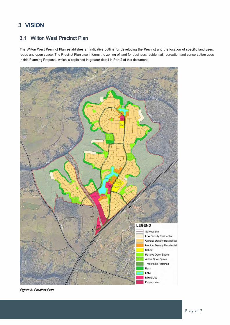
The Wilton West Precinct Plan establishes an indicative outline for developing the Precinct and the location of specific land uses,
roads and open space. The Precinct Plan also informs the zoning of land for business, residential, recreation and conservation uses
in this Planning Proposal, which is explained in greater detail in Part 2 of this document.
Figure 6: Precinct Plan
P a g e | 8
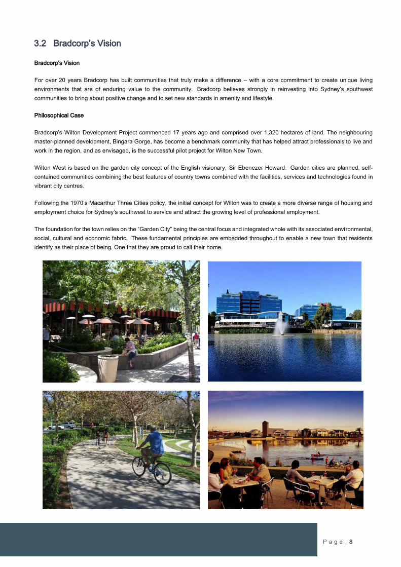
3.2 Bradcorp’s Vision
Bradcorp’s Vision
For over 20 years Bradcorp has built communities that truly make a difference – with a core commitment to create unique living
environments that are of enduring value to the community. Bradcorp believes strongly in reinvesting into Sydney’s southwest
communities to bring about positive change and to set new standards in amenity and lifestyle.
Philosophical Case
Bradcorp’s Wilton Development Project commenced 17 years ago and comprised over 1,320 hectares of land. The neighbouring
master-planned development, Bingara Gorge, has become a benchmark community that has helped attract professionals to live and
work in the region, and as envisaged, is the successful pilot project for Wilton New Town.
Wilton West is based on the garden city concept of the English visionary, Sir Ebenezer Howard. Garden cities are planned, self-
contained communities combining the best features of country towns combined with the facilities, services and technologies found in
vibrant city centres.
Following the 1970’s Macarthur Three Cities policy, the initial concept for Wilton was to create a more diverse range of housing and
employment choice for Sydney’s southwest to service and attract the growing level of professional employment.
The foundation for the town relies on the “Garden City” being the central focus and integrated whole with its associated environmental,
social, cultural and economic fabric. These fundamental principles are embedded throughout to enable a new town that residents
identify as their place of being. One that they are proud to call their home.
P a g e | 9
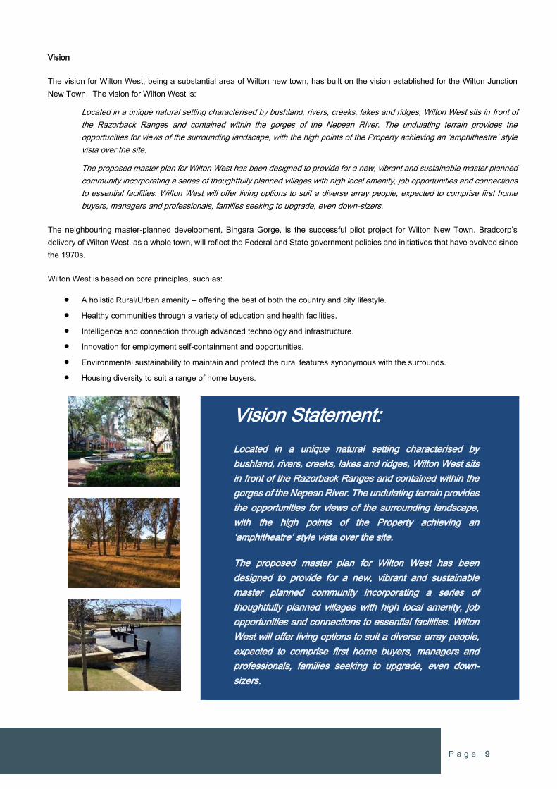
Vision
The vision for Wilton West, being a substantial area of Wilton new town, has built on the vision established for the Wilton Junction
New Town. The vision for Wilton West is:
Located in a unique natural setting characterised by bushland, rivers, creeks, lakes and ridges, Wilton West sits in front of
the Razorback Ranges and contained within the gorges of the Nepean River. The undulating terrain provides the
opportunities for views of the surrounding landscape, with the high points of the Property achieving an ‘amphitheatre’ style
vista over the site.
The proposed master plan for Wilton West has been designed to provide for a new, vibrant and sustainable master planned
community incorporating a series of thoughtfully planned villages with high local amenity, job opportunities and connections
to essential facilities. Wilton West will offer living options to suit a diverse array people, expected to comprise first home
buyers, managers and professionals, families seeking to upgrade, even down-sizers.
The neighbouring master-planned development, Bingara Gorge, is the successful pilot project for Wilton New Town. Bradcorp’s
delivery of Wilton West, as a whole town, will reflect the Federal and State government policies and initiatives that have evolved since
the 1970s.
Wilton West is based on core principles, such as:
A holistic Rural/Urban amenity – offering the best of both the country and city lifestyle.
Healthy communities through a variety of education and health facilities.
Intelligence and connection through advanced technology and infrastructure.
Innovation for employment self-containment and opportunities.
Environmental sustainability to maintain and protect the rural features synonymous with the surrounds.
Housing diversity to suit a range of home buyers.
Vision Statement:
Located in a unique natural setting characterised by
bushland, rivers, creeks, lakes and ridges, Wilton West sits
in front of the Razorback Ranges and contained within the
gorges of the Nepean River. The undulating terrain provides
the opportunities for views of the surrounding landscape,
with the high points of the Property achieving an
‘amphitheatre’ style vista over the site.
The proposed master plan for Wilton West has been
designed to provide for a new, vibrant and sustainable
master planned community incorporating a series of
thoughtfully planned villages with high local amenity, job
opportunities and connections to essential facilities. Wilton
West will offer living options to suit a diverse array people,
expected to comprise first home buyers, managers and
professionals, families seeking to upgrade, even down-
sizers.
P a g e | 10
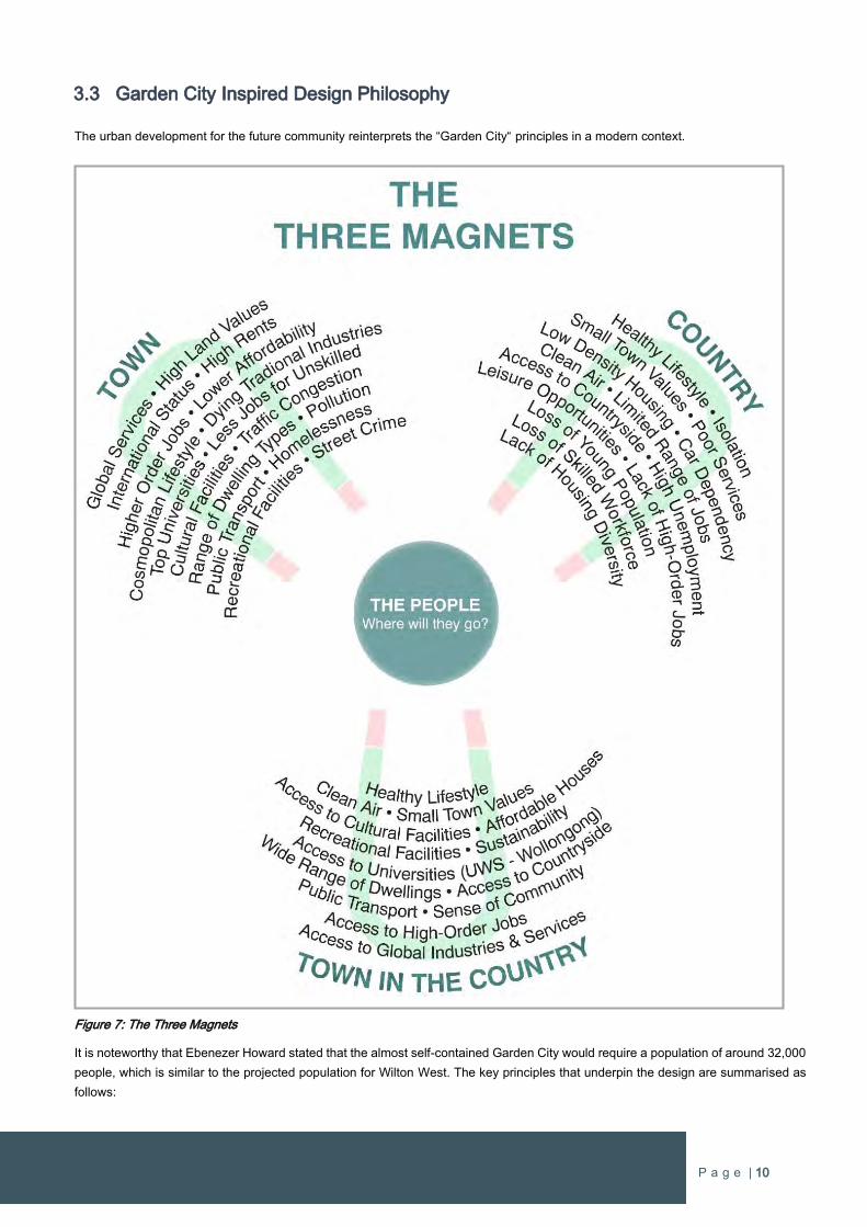
3.3 Garden City Inspired Design Philosophy
The urban development for the future community reinterprets the “Garden City“ principles in a modern context.
Figure 7: The Three Magnets
It is noteworthy that Ebenezer Howard stated that the almost self-contained Garden City would require a population of around 32,000
people, which is similar to the projected population for Wilton West. The key principles that underpin the design are summarised as
follows:
P a g e | 11
Rural living
Bringing nature closer to people.
Connecting green spaces with where people live.
Providing higher levels of residential amenity.
Creating healthier communities.
Urban living
Facilitating greater social interaction and community participation.
Creating safe and attractive neighbourhoods.
Providing access to quality housing at lower cost.
Economics & employment
Providing jobs close to where people live.
Ensuring convenient access to goods, services and facilities.
Providing opportunities for inclusion in a diverse range of activities.
P a g e | 12
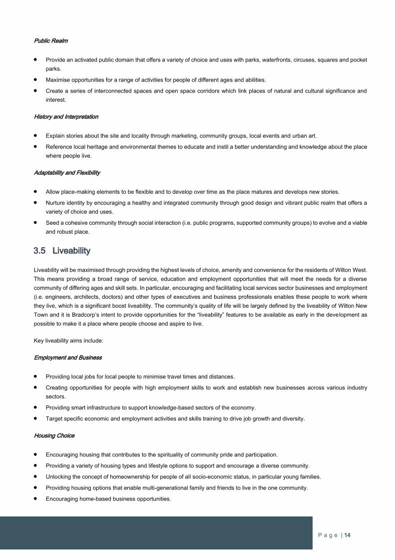
In additional to the principles listed in Section 3.2, the key principles above are to form the underlying objectives for creating a new
community within Wilton West. The contemporary interpretation of the Garden City values and design principles is simply creating
opportunities for people to live in open areas near natural green spaces and fresh air. It is also creating locally based economic and
employment opportunities to maximise opportunities for people to undertake a diverse range of recreational activities, and live in
quality housing and appealing neighbourhoods that are strengthened by community participation. These values are as important and
relevant to creating a new town as they were in the late 19th Century and the site at Wilton has a significant advantage as it can uphold
all of these values easily, which cannot be achieved in any other growth areas around Sydney.
As Wilton West is in the early planning stages, there is a significant opportunity to create an urban area that has strong connections
with the surrounding natural and rural environment. The above key principles are no different from what is considered best planning
outcomes for any new development. However, the distinct advantage is that the site within Wilton West has the physical attributes to
realise the key values and a landowner proponent committed to deliver on these values. In addition, the scale of the project ensures
that commitments to creating new jobs, local services, and state and local infrastructure can be fulfilled.
One of the challenges is properly responding to the present-day environmental, economic and social needs. Today’s society is highly
mobile and will travel long distances to work. There is also community expectation for better environmental and sustainability
outcomes, and there is a significantly broader range in the socio-demographics profile of the residents in new Greenfield release
areas.
Wilton West will be defined by creating a place where people want to live by choice. People will want to live in Wilton West because
they can be close to work, services and facilities, while living close to nature and having a strong connection with the environment. In
particular, there will be a strong connection with the surrounding bushland that will include facilities (i.e. walking and cycles trails,
recreation nodes and fitness centres) that will encourage people to interact with nature, leading to more active and healthier lifestyles.
P a g e | 13
3.4 Excellence in Design
Bradcorp strive to achieve excellence in design to ensure the creation of unique living environments that embody everlasting value
for the community and future generations. Bradcorp has a desire to champion quality in Wilton New Town with Wilton West, which
will establish high standards from day one. Good urban design is critical to meeting this commitment to ensure the local character
and desired form results in Wilton West being an identifiable human living environment with a memorable place to live, work, play and
learn.
Key design considerations include:
Integrating and mixing activities and maximising multi-use opportunities.
Using topography and natural features to establish character and make memorable places.
Locate higher residential densities to help support the provision of more local services.
Encouraging a higher proportion of locally available jobs.
Encouraging a mixture of uses with and adjoining activity hubs.
Locating education near activity nodes.
Provide an interconnected street network.
Ensure neighbourhoods have easy access to activity centres.
Locating low intensity residential and non-residential uses away from commercial centres.
Maximising efficiency in the use of land with a diverse range of land uses and housing types.
Distributing local parks, green linkages and recreation facilities to increase access for residents and workers.
Bradcorp is dedicated to establishing an identity for Wilton West that will establish a “sense of place” for the community. Good place-
making works on a local level with the integration of local identity and local features to create a place that upholds best practice urban
design principles which is embedded in the local context of its place. This will be a combination of responding to the natural features
of the site and incorporating new quality public spaces, including a new large lake, to activate a vibrant public domain and create
meaningful connections between people and where they live.
A common “sense of place” can enhance communities and can be achieved through adopting “points of difference” features including
the following:
Landscape and Topography
Align residential streets and street blocks to work with contours and take advantage of view across the bushland and Razorbacks.
Situate local parks and public open space in areas that can benefit from the landscape setting.
Locate activity nodes in response to natural features.
Use plant species that are sympathetic and compatible with the natural landscape.
Utilise landscape and topography to create a local identity, reinforce this with design that interfaces into the natural landscape.
Highlight Features of Interest
Orientate streets and boulevards to capture majestic views, such as the Razorback Ranges.
Use natural features (i.e. hilltops) as landmarks, gateways and termination points for vistas.
Ensure elevated areas provide views from streets and homes to the bushland and its setting.
P a g e | 14
Public Realm
Provide an activated public domain that offers a variety of choice and uses with parks, waterfronts, circuses, squares and pocket
parks.
Maximise opportunities for a range of activities for people of different ages and abilities.
Create a series of interconnected spaces and open space corridors which link places of natural and cultural significance and
interest.
History and Interpretation
Explain stories about the site and locality through marketing, community groups, local events and urban art.
Reference local heritage and environmental themes to educate and instil a better understanding and knowledge about the place
where people live.
Adaptability and Flexibility
Allow place-making elements to be flexible and to develop over time as the place matures and develops new stories.
Nurture identity by encouraging a healthy and integrated community through good design and vibrant public realm that offers a
variety of choice and uses.
Seed a cohesive community through social interaction (i.e. public programs, supported community groups) to evolve and a viable
and robust place.
3.5 Liveability
Liveability will be maximised through providing the highest levels of choice, amenity and convenience for the residents of Wilton West.
This means providing a broad range of service, education and employment opportunities that will meet the needs for a diverse
community of differing ages and skill sets. In particular, encouraging and facilitating local services sector businesses and employment
(i.e. engineers, architects, doctors) and other types of executives and business professionals enables these people to work where
they live, which is a significant boost liveability. The community’s quality of life will be largely defined by the liveability of Wilton New
Town and it is Bradcorp’s intent to provide opportunities for the “liveability” features to be available as early in the deve lopment as
possible to make it a place where people choose and aspire to live.
Key liveability aims include:
Employment and Business
Providing local jobs for local people to minimise travel times and distances.
Creating opportunities for people with high employment skills to work and establish new businesses across various industry
sectors.
Providing smart infrastructure to support knowledge-based sectors of the economy.
Target specific economic and employment activities and skills training to drive job growth and diversity.
Housing Choice
Encouraging housing that contributes to the spirituality of community pride and participation.
Providing a variety of housing types and lifestyle options to support and encourage a diverse community.
Unlocking the concept of homeownership for people of all socio-economic status, in particular young families.
Providing housing options that enable multi-generational family and friends to live in the one community.
Encouraging home-based business opportunities.
P a g e | 15
Creating living options for seniors that include the opportunity for knowledge transfer and life-long learning.
Shops and Services
Encouraging a range of shopping and services that minimise the need to travel to other locations.
Creating an activity node adjacent to a large waterbody that attracts businesses and provides night time hospitality and
entertainment activities.
Enabling restaurants, cafes and bars where people can meet and socialise with friends and family.
Transport
Providing legible and understandable network of residential streets, roads, cycleways and paths that enable people to easily
navigate their way around the New Town.
Enabling public transport access for all residents in the community.
Providing strong connections to major roads and other transport modes to ensure easy access to other regional centres.
Education
Providing Public and private schools from kindergarten to year 12.
Facilitating and evolving opportunities for post-school and tertiary education facilities.
Open Space and Recreation
Providing local parks and active recreation facilities that are close to where people live.
Building a large waterbody that will form a centrepiece for Wilton New Town and feature that will attract people.
Delivering a network of pathways that connect people’s homes to activity nodes, recreation areas, bushland, schools and
workplaces.
Sustainability and the Environment
Protecting and conserving the features of environmental significance.
Enabling access to bushland and waterways that is managed to preserve the environment.
Establishing an Environmental Trust to manage natural resources and facilitate community engagement, education and
recreation.
Facilitate partnerships with key learning providers to create vocational education and training opportunities and a culture of
‘learning for life’.
Establishing initiatives such as landscaping for residents, educational programs and a community nursery for indigenous local
plants.
3.6 Driving Socio-Economic Change in South West Sydney
Bradcorp are committed to making Wilton West within Wilton New Town a project that drives socio-economic change in South West
Sydney. Wilton West is one of the largest single urban development projects in Sydney which enables Bradcorp to commit to services,
facilities and the early delivery of State infrastructure. With a projected yield of approximately 5,400 homes, there is an ability to create
a place that has new major road connections, new schools and education facilities, and local services and employment for people of
all skill sets and academic achievement.
Historically South West Sydney has low levels of professionals, executives and business owners living and working in the region.
People of these higher level jobs typically live in the areas closer to the Sydney CBD and in areas throughout the northern suburbs of
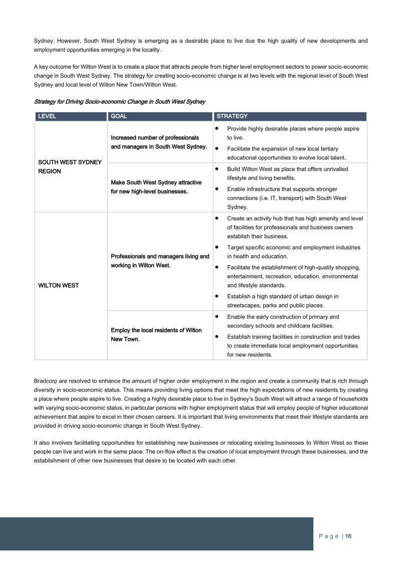
P a g e | 16
Sydney. However, South West Sydney is emerging as a desirable place to live due the high quality of new developments and
employment opportunities emerging in the locality.
A key outcome for Wilton West is to create a place that attracts people from higher level employment sectors to power socio-economic
change in South West Sydney. The strategy for creating socio-economic change is at two levels with the regional level of South West
Sydney and local level of Wilton New Town/Wilton West.
Strategy for Driving Socio-economic Change in South West Sydney
LEVEL GOAL STRATEGY
SOUTH WEST SYDNEY
REGION
Increased number of professionals
and managers in South West Sydney.
Provide highly desirable places where people aspire
to live.
Facilitate the expansion of new local tertiary
educational opportunities to evolve local talent.
Make South West Sydney attractive
for new high-level businesses.
Build Wilton West as place that offers unrivalled
lifestyle and living benefits.
Enable infrastructure that supports stronger
connections (i.e. IT, transport) with South West
Sydney.
WILTON WEST
Professionals and managers living and
working in Wilton West.
Create an activity hub that has high amenity and level
of facilities for professionals and business owners
establish their business.
Target specific economic and employment industries
in health and education.
Facilitate the establishment of high-quality shopping,
entertainment, recreation, education, environmental
and lifestyle standards.
Establish a high standard of urban design in
streetscapes, parks and public places.
Employ the local residents of Wilton
New Town.
Enable the early construction of primary and
secondary schools and childcare facilities.
Establish training facilities in construction and trades
to create immediate local employment opportunities
for new residents.
Bradcorp are resolved to enhance the amount of higher order employment in the region and create a community that is rich through
diversity in socio-economic status. This means providing living options that meet the high expectations of new residents by creating
a place where people aspire to live. Creating a highly desirable place to live in Sydney’s South West will attract a range of households
with varying socio-economic status, in particular persons with higher employment status that will employ people of higher educational
achievement that aspire to excel in their chosen careers. It is important that living environments that meet their lifestyle standards are
provided in driving socio-economic change in South West Sydney.
It also involves facilitating opportunities for establishing new businesses or relocating existing businesses to Wilton West so these
people can live and work in the same place. The on-flow effect is the creation of local employment through these businesses, and the
establishment of other new businesses that desire to be located with each other.

P a g e | 17
3.7 Employment
Bradcorp is committed to establishing early and targeted economic and employment growth to support local jobs and services for
Wilton West from day one. Wilton West can deliver greater employment creation than the employment targets of the Wollondilly Shire
Council and NSW Government to ensure sustainable employment for “one job per dwelling” in Wilton New Town throughout the
lifecycle of the project. This is achieved by developing economic plans for new jobs and proactively targeting the key growth driver for
each phase.
Economic specialist MacroPlan Dimasi has prepared an Employment Strategy comprising an economic plan and targeted employment
strategy to guide the early establishment of local services and jobs for future residents, and the ongoing creation of new jobs
throughout the growth of Wilton New Town (refer to “Wilton Lakeside Precinct: Employment Strategy & Economic Masterplan” dated
December 2016 by MacroPlan Dimasi in Appendix 1).
Whilst Wilton West is to contain two local activity centres with around 5,000m2 of retail uses, the focus of establishing permanent local
jobs in the Lakeside Activity Hub will target jobs in the services sector, which represents around 80 percent of all employment Australia-
wide and is increasing (Page ii, Executive Summary). It is important to recognise that the services sector embraces the full range of
services, from basic needs and requirements to high level professional consultancy services (i.e. professionals and business owners),
and thus embraces the full spectrum of the community. Furthermore, the services sector is a major generator of employment and with
early planning will form the majority of employment opportunities in Wilton West. It will also ensure that the future Wilton New Town
Centre retains its role as the primary retail centre within Wilton New Town.
3.7.1 Employment Strategy
The Employment Strategy that has been specifically prepared for Wilton West is underpinned by an Economic Masterplan to provide
a basis for job creation. It embraces National, State and Local policies and commitments for economic and employment growth as
well as well as emerging growth drivers under a polycentric centres model.
Page 11 of the Employment Strategy states that the Economic Masterplan driving the employment outcomes includes:
Meeting existing gaps based on demand e.g. already committed to a K-12 Anglican College.
Trapping construction multipliers locally (Including professional and management rolls).
Leveraging the fastest growing economic sectors i.e. health and education.
Attracting small to medium size (SME’s) enterprises and contractors.
Leveraging local amenity (i.e. the lake) to accommodate a wide range of recreational cases (e.g. club, gymnasium) and
regional meetings and conferences.
Provision of service retail to service local needs, recognising the regional retail centre will not be feasible for around 10
years.
Leveraging ingress and egress to the freeway to accommodate a range of regional and sub-regional uses including
emergency services, transport services, home care services etc.
The Lakeside Precinct Economic Plan complements the proposed future Regional Centre and focuses on a range of uses
which vertically integrate by sectors e.g. health.
The health sector will have an important role in employment and the service economy, which will primarily focus on servicing the
ageing population. In the National context, the Strategy notes that the health sector is the largest employment sector in the Australian
economy:
“The health sector however, with 13% of total jobs (1.52 million) remains the largest sector, which is a focal point for
the lakeside Precinct.” (P25)
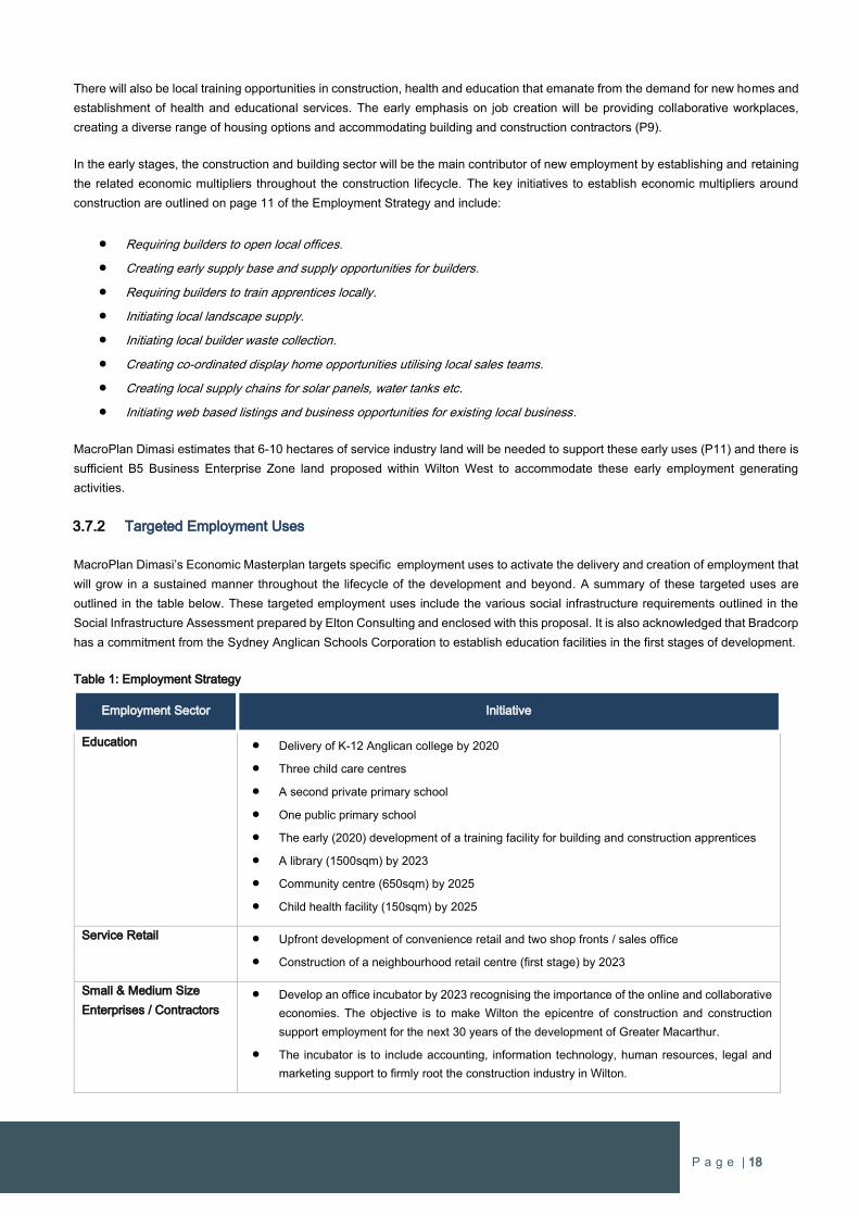
P a g e | 18
There will also be local training opportunities in construction, health and education that emanate from the demand for new homes and
establishment of health and educational services. The early emphasis on job creation will be providing collaborative workplaces,
creating a diverse range of housing options and accommodating building and construction contractors (P9).
In the early stages, the construction and building sector will be the main contributor of new employment by establishing and retaining
the related economic multipliers throughout the construction lifecycle. The key initiatives to establish economic multipliers around
construction are outlined on page 11 of the Employment Strategy and include:
Requiring builders to open local offices.
Creating early supply base and supply opportunities for builders.
Requiring builders to train apprentices locally.
Initiating local landscape supply.
Initiating local builder waste collection.
Creating co-ordinated display home opportunities utilising local sales teams.
Creating local supply chains for solar panels, water tanks etc.
Initiating web based listings and business opportunities for existing local business.
MacroPlan Dimasi estimates that 6-10 hectares of service industry land will be needed to support these early uses (P11) and there is
sufficient B5 Business Enterprise Zone land proposed within Wilton West to accommodate these early employment generating
activities.
3.7.2 Targeted Employment Uses
MacroPlan Dimasi’s Economic Masterplan targets specific employment uses to activate the delivery and creation of employment that
will grow in a sustained manner throughout the lifecycle of the development and beyond. A summary of these targeted uses are
outlined in the table below. These targeted employment uses include the various social infrastructure requirements outlined in the
Social Infrastructure Assessment prepared by Elton Consulting and enclosed with this proposal. It is also acknowledged that Bradcorp
has a commitment from the Sydney Anglican Schools Corporation to establish education facilities in the first stages of development.
Table 1: Employment Strategy
Employment Sector Initiative
Education Delivery of K-12 Anglican college by 2020
Three child care centres
A second private primary school
One public primary school
The early (2020) development of a training facility for building and construction apprentices
A library (1500sqm) by 2023
Community centre (650sqm) by 2025
Child health facility (150sqm) by 2025
Service Retail Upfront development of convenience retail and two shop fronts / sales office
Construction of a neighbourhood retail centre (first stage) by 2023
Small & Medium Size
Enterprises / Contractors
Develop an office incubator by 2023 recognising the importance of the online and collaborative
economies. The objective is to make Wilton the epicentre of construction and construction
support employment for the next 30 years of the development of Greater Macarthur.
The incubator is to include accounting, information technology, human resources, legal and
marketing support to firmly root the construction industry in Wilton.
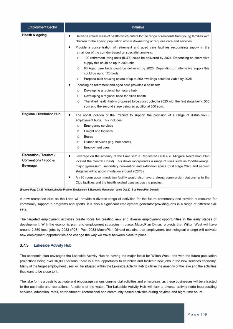
P a g e | 19
Employment Sector Initiative
Health & Ageing Deliver a critical mass of health which caters for the range of residents from young families with
children to the ageing population who is downsizing or requires care and services.
Provide a concentration of retirement and aged care facilities recognising supply in the
remainder of the corridor based on specialist analysis:
o 100 retirement living units (ILU’s) could be delivered by 2024. Depending on alternative
supply this could be up to 200 units.
o 80 Aged care beds could be delivered by 2025. Depending on alternative supply this
could be up to 120 beds.
o Purpose-built housing estate of up to 200 dwellings could be viable by 2025
Focusing on retirement and aged care provides a basis for:
o Developing a regional homecare hub
o Developing a regional base for allied health.
o The allied health hub is proposed to be constructed in 2025 with the first stage being 500
sqm and the second stage being an additional 500 sqm.
Regional Distribution Hub The nodal location of the Precinct to support the provision of a range of distribution /
employment hubs. This includes:
o Emergency services
o Freight and logistics
o Buses
o Human services (e.g. homecare)
o Employment uses
Recreation / Tourism /
Conventions / Food &
Beverage
Leverage on the amenity of the Lake with a Registered Club (i.e. Mingara Recreation Club
located the Central Coast). This driver incorporates a range of uses such as food/beverage,
major gymnasium, secondary convention and exhibition space (first stage 2023 and second
stage including accommodation around 2027/8).
An 80 room accommodation facility would also have a strong commercial relationship to the
Club facilities and the health related uses across the precinct.
(Source: Page 23-25 ‘Wilton Lakeside Precinct Employment & Economic Masterplan’ dated Oct 2016 by MacroPlan Dimasi)
A new recreation club on the Lake will provide a diverse range of activities for the future community and provide a resource for
community support in programs and sports. It is also a significant employment generator providing jobs in a range of different skill
sets.
The targeted employment activities create focus for creating new and diverse employment opportunities in the early stages of
development. With the economic plan and employment strategies in place, MacroPlan Dimasi projects that Wilton West will have
around 2,350 local jobs by 2033 (P26). Post 2033 MacroPlan Dimasi explains that employment technological change will activate
new employment opportunities and change the way we travel between place to place.
3.7.3 Lakeside Activity Hub
The economic plan envisages the Lakeside Activity Hub as having the major focus for Wilton West, and with the future population
projections being over 16,000 persons, there is a real opportunity to establish and facilitate new jobs in the new services economy.
Many of the target employment uses will be situated within the Lakeside Activity Hub to utilise the amenity of the lake and the activities
that want to be close to it.
The lake forms a basis to activate and encourage various commercial activities and enterprises, as these businesses will be attracted
to the aesthetic and recreational functions of the water. The Lakeside Activity Hub will form a diverse activity node incorporating
services, education, retail, entertainment, recreational and community based activities during daytime and night-time hours.
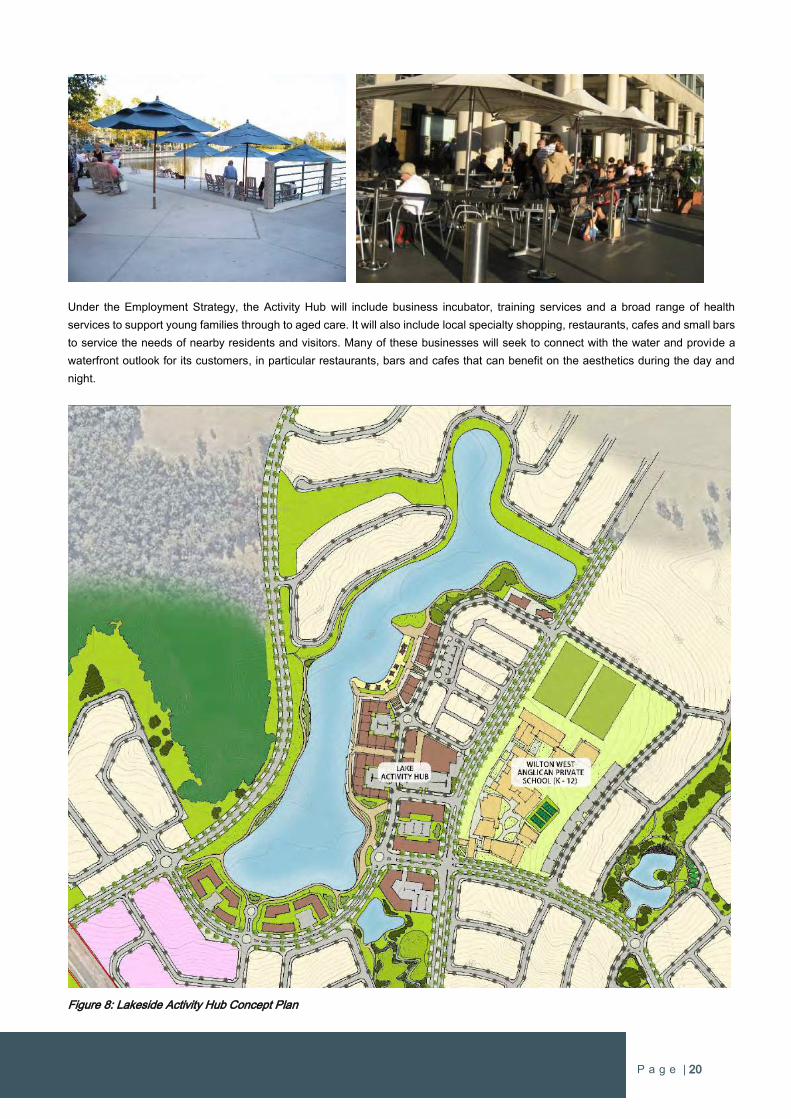
P a g e | 20
Under the Employment Strategy, the Activity Hub will include business incubator, training services and a broad range of health
services to support young families through to aged care. It will also include local specialty shopping, restaurants, cafes and small bars
to service the needs of nearby residents and visitors. Many of these businesses will seek to connect with the water and provide a
waterfront outlook for its customers, in particular restaurants, bars and cafes that can benefit on the aesthetics during the day and
night.
Figure 8: Lakeside Activity Hub Concept Plan
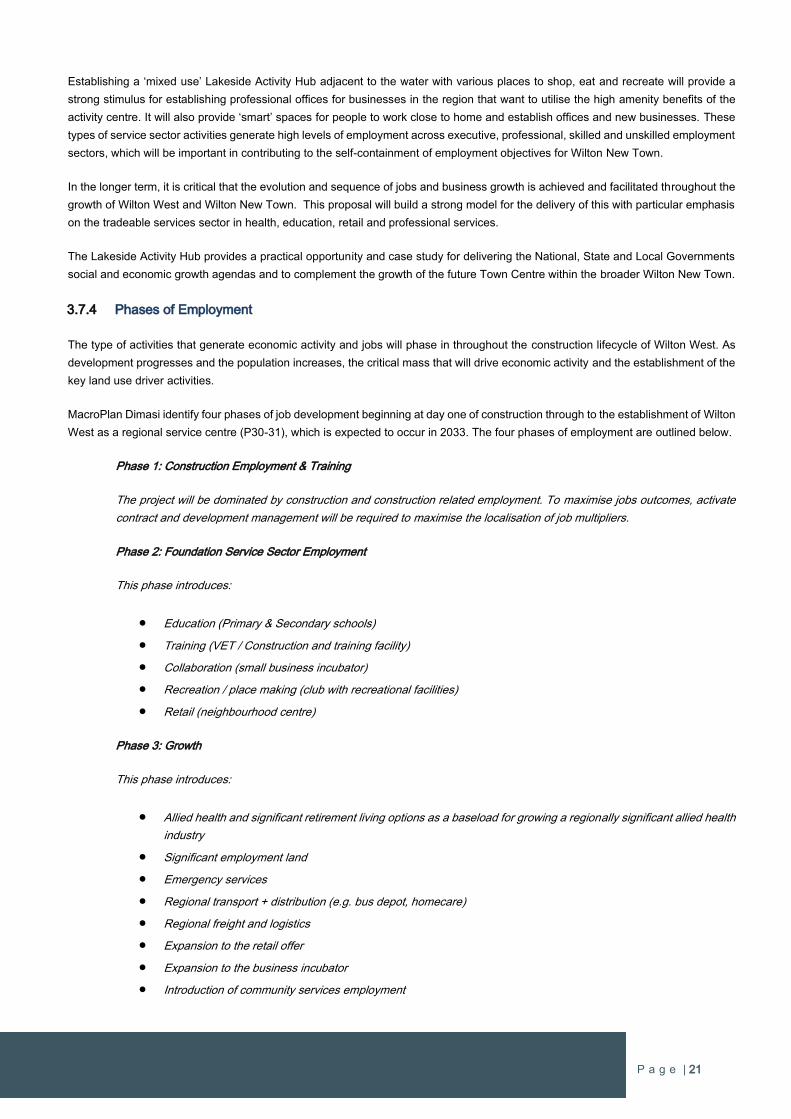
P a g e | 21
Establishing a ‘mixed use’ Lakeside Activity Hub adjacent to the water with various places to shop, eat and recreate will provide a
strong stimulus for establishing professional offices for businesses in the region that want to utilise the high amenity benefits of the
activity centre. It will also provide ‘smart’ spaces for people to work close to home and establish offices and new businesses. These
types of service sector activities generate high levels of employment across executive, professional, skilled and unskilled employment
sectors, which will be important in contributing to the self-containment of employment objectives for Wilton New Town.
In the longer term, it is critical that the evolution and sequence of jobs and business growth is achieved and facilitated throughout the
growth of Wilton West and Wilton New Town. This proposal will build a strong model for the delivery of this with particular emphasis
on the tradeable services sector in health, education, retail and professional services.
The Lakeside Activity Hub provides a practical opportunity and case study for delivering the National, State and Local Governments
social and economic growth agendas and to complement the growth of the future Town Centre within the broader Wilton New Town.
3.7.4 Phases of Employment
The type of activities that generate economic activity and jobs will phase in throughout the construction lifecycle of Wilton West. As
development progresses and the population increases, the critical mass that will drive economic activity and the establishment of the
key land use driver activities.
MacroPlan Dimasi identify four phases of job development beginning at day one of construction through to the establishment of Wilton
West as a regional service centre (P30-31), which is expected to occur in 2033. The four phases of employment are outlined below.
Phase 1: Construction Employment & Training
The project will be dominated by construction and construction related employment. To maximise jobs outcomes, activate
contract and development management will be required to maximise the localisation of job multipliers.
Phase 2: Foundation Service Sector Employment
This phase introduces:
Education (Primary & Secondary schools)
Training (VET / Construction and training facility)
Collaboration (small business incubator)
Recreation / place making (club with recreational facilities)
Retail (neighbourhood centre)
Phase 3: Growth
This phase introduces:
Allied health and significant retirement living options as a baseload for growing a regionally significant allied health
industry
Significant employment land
Emergency services
Regional transport + distribution (e.g. bus depot, homecare)
Regional freight and logistics
Expansion to the retail offer
Expansion to the business incubator
Introduction of community services employment
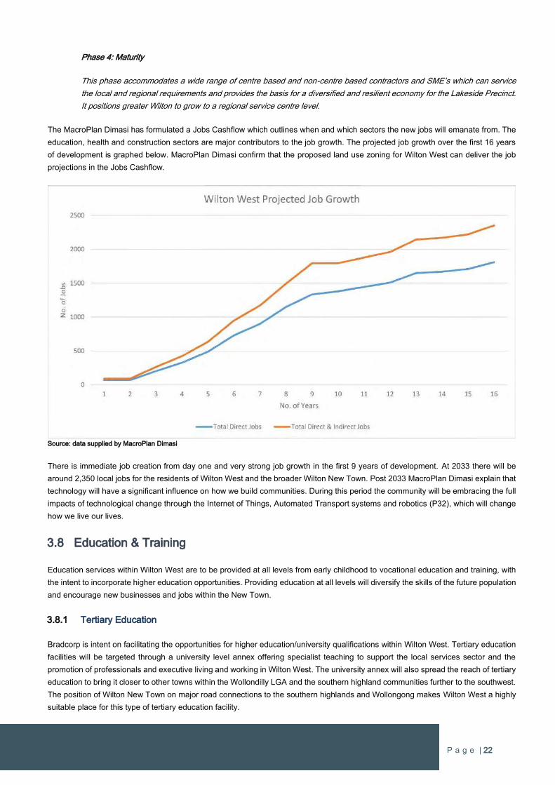
P a g e | 22
Phase 4: Maturity
This phase accommodates a wide range of centre based and non-centre based contractors and SME’s which can service
the local and regional requirements and provides the basis for a diversified and resilient economy for the Lakeside Precinct.
It positions greater Wilton to grow to a regional service centre level.
The MacroPlan Dimasi has formulated a Jobs Cashflow which outlines when and which sectors the new jobs will emanate from. The
education, health and construction sectors are major contributors to the job growth. The projected job growth over the first 16 years
of development is graphed below. MacroPlan Dimasi confirm that the proposed land use zoning for Wilton West can deliver the job
projections in the Jobs Cashflow.
Source: data supplied by MacroPlan Dimasi
There is immediate job creation from day one and very strong job growth in the first 9 years of development. At 2033 there will be
around 2,350 local jobs for the residents of Wilton West and the broader Wilton New Town. Post 2033 MacroPlan Dimasi explain that
technology will have a significant influence on how we build communities. During this period the community will be embracing the full
impacts of technological change through the Internet of Things, Automated Transport systems and robotics (P32), which will change
how we live our lives.
3.8 Education & Training
Education services within Wilton West are to be provided at all levels from early childhood to vocational education and training, with
the intent to incorporate higher education opportunities. Providing education at all levels will diversify the skills of the future population
and encourage new businesses and jobs within the New Town.
3.8.1 Tertiary Education
Bradcorp is intent on facilitating the opportunities for higher education/university qualifications within Wilton West. Tertiary education
facilities will be targeted through a university level annex offering specialist teaching to support the local services sector and the
promotion of professionals and executive living and working in Wilton West. The university annex will also spread the reach of tertiary
education to bring it closer to other towns within the Wollondilly LGA and the southern highland communities further to the southwest.
The position of Wilton New Town on major road connections to the southern highlands and Wollongong makes Wilton West a highly
suitable place for this type of tertiary education facility.
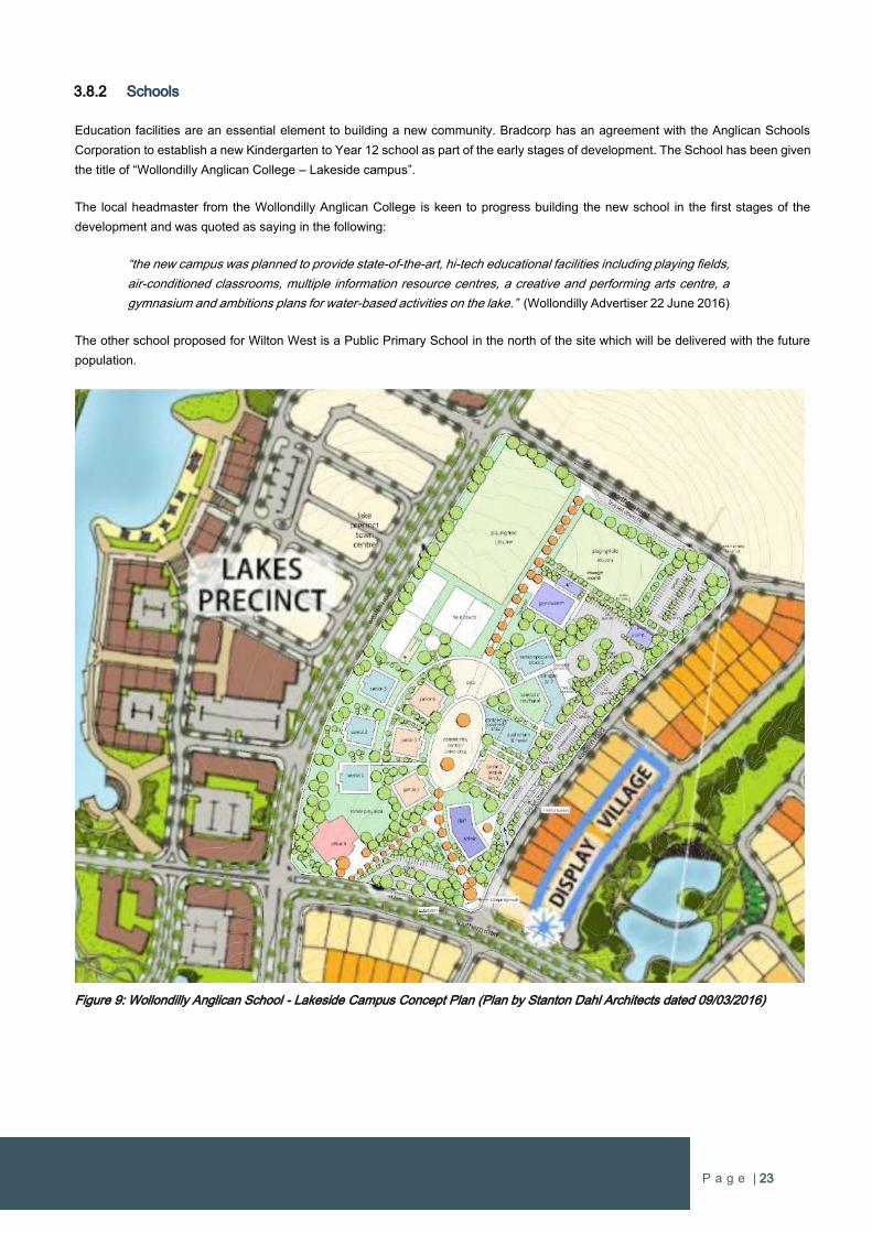
P a g e | 23
3.8.2 Schools
Education facilities are an essential element to building a new community. Bradcorp has an agreement with the Anglican Schools
Corporation to establish a new Kindergarten to Year 12 school as part of the early stages of development. The School has been given
the title of “Wollondilly Anglican College – Lakeside campus”.
The local headmaster from the Wollondilly Anglican College is keen to progress building the new school in the first stages of the
development and was quoted as saying in the following:
“the new campus was planned to provide state-of-the-art, hi-tech educational facilities including playing fields,
air-conditioned classrooms, multiple information resource centres, a creative and performing arts centre, a
gymnasium and ambitions plans for water-based activities on the lake.” (Wollondilly Advertiser 22 June 2016)
The other school proposed for Wilton West is a Public Primary School in the north of the site which will be delivered with the future
population.
Figure 9: Wollondilly Anglican School - Lakeside Campus Concept Plan (Plan by Stanton Dahl Architects dated 09/03/2016)
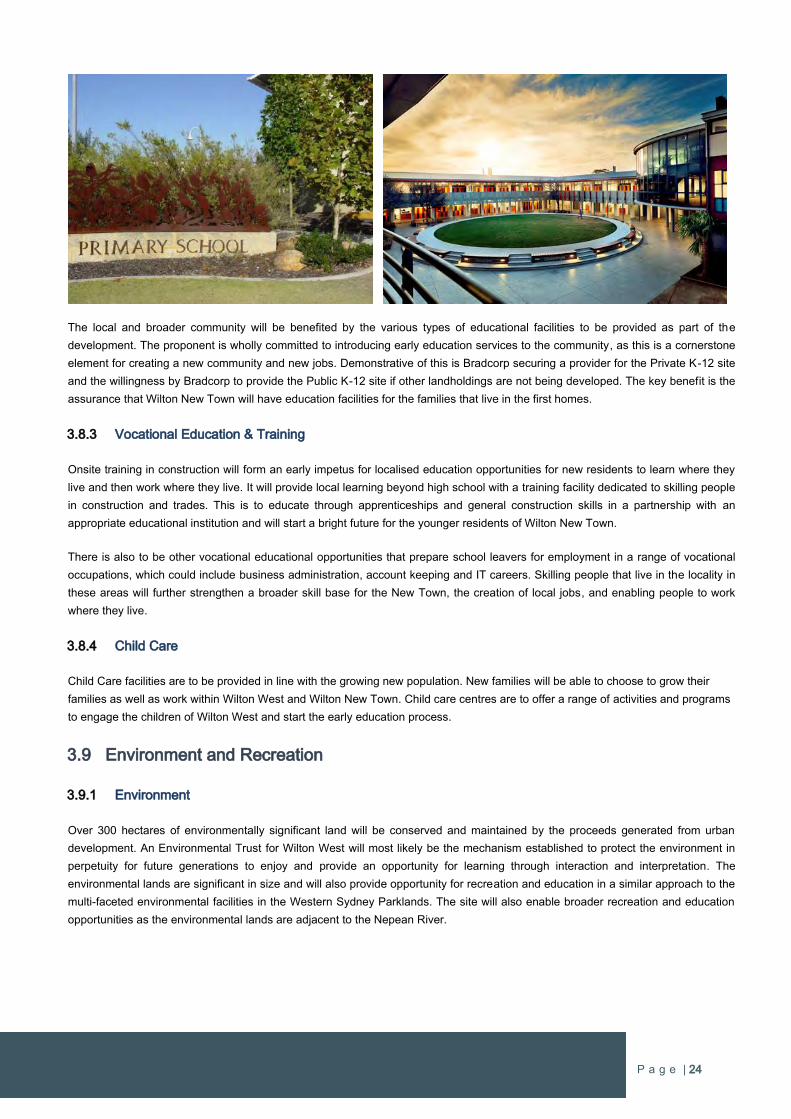
P a g e | 24
The local and broader community will be benefited by the various types of educational facilities to be provided as part of the
development. The proponent is wholly committed to introducing early education services to the community, as this is a cornerstone
element for creating a new community and new jobs. Demonstrative of this is Bradcorp securing a provider for the Private K-12 site
and the willingness by Bradcorp to provide the Public K-12 site if other landholdings are not being developed. The key benefit is the
assurance that Wilton New Town will have education facilities for the families that live in the first homes.
3.8.3 Vocational Education & Training
Onsite training in construction will form an early impetus for localised education opportunities for new residents to learn where they
live and then work where they live. It will provide local learning beyond high school with a training facility dedicated to skilling people
in construction and trades. This is to educate through apprenticeships and general construction skills in a partnership with an
appropriate educational institution and will start a bright future for the younger residents of Wilton New Town.
There is also to be other vocational educational opportunities that prepare school leavers for employment in a range of vocational
occupations, which could include business administration, account keeping and IT careers. Skilling people that live in the locality in
these areas will further strengthen a broader skill base for the New Town, the creation of local jobs, and enabling people to work
where they live.
3.8.4 Child Care
Child Care facilities are to be provided in line with the growing new population. New families will be able to choose to grow their
families as well as work within Wilton West and Wilton New Town. Child care centres are to offer a range of activities and programs
to engage the children of Wilton West and start the early education process.
3.9 Environment and Recreation
3.9.1 Environment
Over 300 hectares of environmentally significant land will be conserved and maintained by the proceeds generated from urban
development. An Environmental Trust for Wilton West will most likely be the mechanism established to protect the environment in
perpetuity for future generations to enjoy and provide an opportunity for learning through interaction and interpretation. The
environmental lands are significant in size and will also provide opportunity for recreation and education in a similar approach to the
multi-faceted environmental facilities in the Western Sydney Parklands. The site will also enable broader recreation and education
opportunities as the environmental lands are adjacent to the Nepean River.
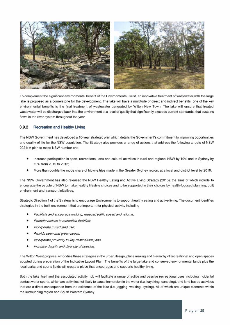
P a g e | 25
To complement the significant environmental benefit of the Environmental Trust, an innovative treatment of wastewater with the large
lake is proposed as a cornerstone for the development. The lake will have a multitude of direct and indirect benefits, one of the key
environmental benefits is the final treatment of wastewater generated by Wilton New Town. The lake will ensure that treated
wastewater will be discharged back into the environment at a level of quality that significantly exceeds current standards, that sustains
flows in the river system throughout the year
3.9.2 Recreation and Healthy Living
The NSW Government has developed a 10-year strategic plan which details the Government’s commitment to improving opportunities
and quality of life for the NSW population. The Strategy also provides a range of actions that address the following targets of NSW
2021: A plan to make NSW number one:
Increase participation in sport, recreational, arts and cultural activities in rural and regional NSW by 10% and in Sydney by
10% from 2010 to 2016;
More than double the mode share of bicycle trips made in the Greater Sydney region, at a local and district level by 2016;
The NSW Government has also released the NSW Healthy Eating and Active Living Strategy (2013), the aims of which include to
encourage the people of NSW to make healthy lifestyle choices and to be supported in their choices by health-focused planning, built
environment and transport initiatives.
Strategic Direction 1 of the Strategy is to encourage Environments to support healthy eating and active living. The document identifies
strategies in the built environment that are important for physical activity including
Facilitate and encourage walking, reduced traffic speed and volume;
Promote access to recreation facilities;
Incorporate mixed land use;
Provide open and green space;
Incorporate proximity to key destinations; and
Increase density and diversity of housing.
The Wilton West proposal embodies these strategies in the urban design, place making and hierarchy of recreational and open spaces
adopted during preparation of the Indicative Layout Plan. The benefits of the large lake and conserved environmental lands plus the
local parks and sports fields will create a place that encourages and supports healthy living.
Both the lake itself and the associated activity hub will facilitate a range of active and passive recreational uses including incidental
contact water sports, which are activities not likely to cause immersion in the water (i.e. kayaking, canoeing), and land based activities
that are a direct consequence from the existence of the lake (i.e. jogging, walking, cycling). All of which are unique elements within
the surrounding region and South Western Sydney.
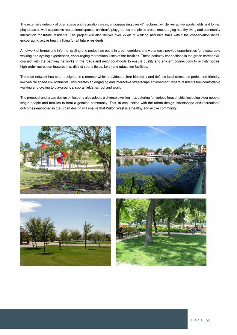
P a g e | 26
The extensive network of open space and recreation areas, encompassing over 47 hectares, will deliver active sports fields and formal
play areas as well as passive recreational spaces, children’s playgrounds and picnic areas, encouraging healthy living and community
interaction for future residents. The project will also deliver over 22km of walking and bike trails within the conservation lands,
encouraging active healthy living for all future residents.
A network of formal and informal cycling and pedestrian paths in green corridors and waterways provide opportunities for pleasurable
walking and cycling experiences, encouraging recreational uses of the facilities. These pathway connections in the green corridor will
connect with the pathway networks in the roads and neighbourhoods to ensure quality and efficient connections to activity nodes,
high-order recreation features (i.e. district sports fields, lake) and education facilities.
The road network has been designed in a manner which provides a clear hierarchy and defines local streets as pedestrian friendly,
low vehicle speed environments. This creates an engaging and interactive streetscape environment, where residents feel comfortable
walking and cycling to playgrounds, sports fields, school and work.
The proposal and urban design philosophy also adopts a diverse dwelling mix, catering for various households, including older people,
single people and families to form a genuine community. This, in conjunction with the urban design, streetscape and recreational
outcomes embodied in the urban design will ensure that Wilton West is a healthy and active community.
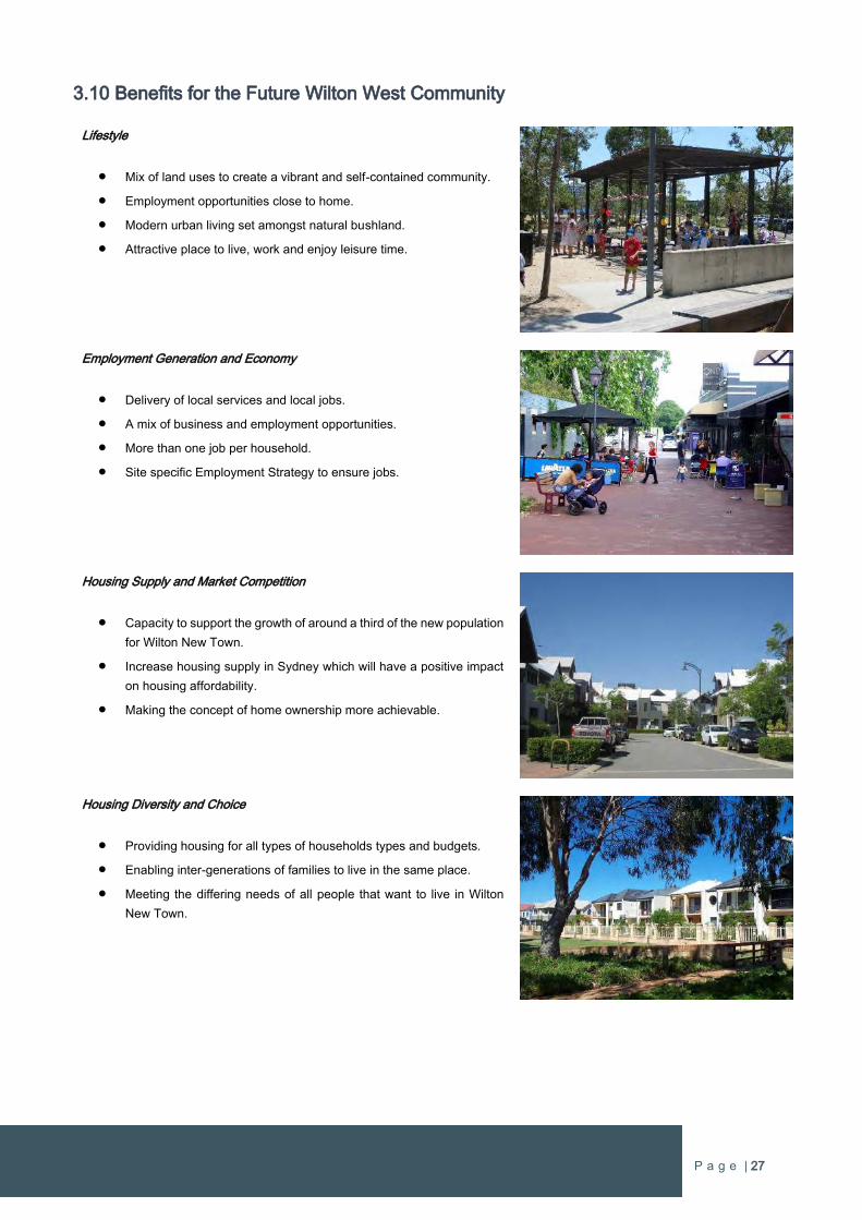
P a g e | 27
3.10 Benefits for the Future Wilton West Community
Lifestyle
Mix of land uses to create a vibrant and self-contained community.
Employment opportunities close to home.
Modern urban living set amongst natural bushland.
Attractive place to live, work and enjoy leisure time.
Employment Generation and Economy
Delivery of local services and local jobs.
A mix of business and employment opportunities.
More than one job per household.
Site specific Employment Strategy to ensure jobs.
Housing Supply and Market Competition
Capacity to support the growth of around a third of the new population
for Wilton New Town.
Increase housing supply in Sydney which will have a positive impact
on housing affordability.
Making the concept of home ownership more achievable.
Housing Diversity and Choice
Providing housing for all types of households types and budgets.
Enabling inter-generations of families to live in the same place.
Meeting the differing needs of all people that want to live in Wilton
New Town.
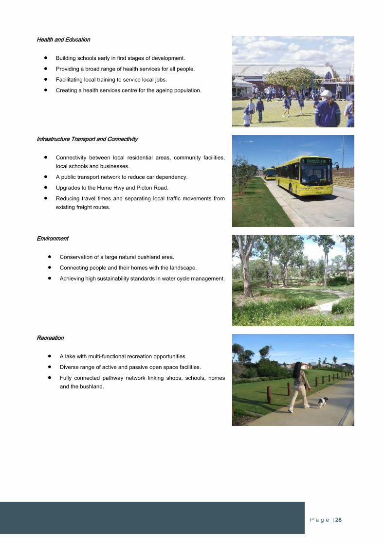
P a g e | 28
Health and Education
Building schools early in first stages of development.
Providing a broad range of health services for all people.
Facilitating local training to service local jobs.
Creating a health services centre for the ageing population.
Infrastructure Transport and Connectivity
Connectivity between local residential areas, community facilities,
local schools and businesses.
A public transport network to reduce car dependency.
Upgrades to the Hume Hwy and Picton Road.
Reducing travel times and separating local traffic movements from
existing freight routes.
Environment
Conservation of a large natural bushland area.
Connecting people and their homes with the landscape.
Achieving high sustainability standards in water cycle management.
Recreation
A lake with multi-functional recreation opportunities.
Diverse range of active and passive open space facilities.
Fully connected pathway network linking shops, schools, homes
and the bushland.
P a g e | 29
4 STRATEGIC PLANNING CONTEXT
4.1 Strategic Planning Overview
The Greater Sydney Commission has been established to lead planning with the focus of making Sydney a “more productive, liveable
and sustainable city for all.” Their role “is to coordinate and align the planning that will shape the future of Greater Sydney” as unified
whole of Government to “lead and guide the planning for development, transport and housing so that Greater Sydney”.
The Greater Sydney Commission released six Draft District Plans for Greater Sydney for public review and comment on 21 November
2016. Wilton West is within the Draft South West District Plan which includes the Local Government Areas of Camden, Campbelltown,
Fairfield, Liverpool and Wollondilly. It also includes the future Western Sydney Airport and the future third ‘aerotropolis’ city of Sydney
known as “Western City”.
The Greater Sydney Commission is concurrently reviewing the current metropolitan strategy for Sydney title “A Plan for Growing
Sydney”, which was published in December 2014. It identifies key focus areas for investigation to deliver Sydney’s housing supply
over the next 20 years. The plan identified approximately 17,600 hectares of land for investigation known as The Greater Macarthur
Investigation Area which incorporated Wilton, including the subject site.
In September 2015 the NSW Government released the Greater Macarthur Land Release Investigation which identified two potential
Priority Growth Areas, one of which is Wilton. In June 2016 the Department of Planning & Environment released a consultation update
which sets out a number of modifications to Greater Macarthur Land Release Investigation. The most significant modification was the
identification of Wilton New Town for immediate action with people moving into their homes in the latter part of 2018.
The Minister for Planning declared the Wilton Priority Growth Area on 29 July 2016. The Priority Growth Area is formalised through
an amendment to the State Environmental Planning Policy (Sydney Region Growth Centres) 2006.
The Bradcorp land is the largest consolidated holding within the new Wilton Priority Growth Area. This provides a unique and strategic
opportunity to deliver a complete community on the whole site from day one.
4.2 Draft South West District Plan
To progress high-level planning outcomes in South West Sydney, the Greater Sydney Commission has prepared and released the
Draft South West District Plan. Whilst the South West District Plan is in draft, it needs to be considered in all Planning Proposals within
any of the relevant councils.
The Draft South West District Plan sets out the vision, priorities (productivity, sustainability and liveability) and actions for the
development of the South West District. The key purpose of the South West District Plan is to inform the preparation of planning
proposals. The District Priorities form the criteria of assessing how any proposal meets the requirements of the District Plan, with all
proposals required to demonstrate how the respective Planning Proposal satisfies the priorities.
A detailed response to all Productivity, Liveability and Sustainability Priorities in the South West District Plan is included in Part B of
this proposal.
4.3 A Plan for Growing Sydney
A Plan for Growing Sydney is the most recent Metropolitan Planning Strategy for the Greater Sydney Region. The Plan was published
in December 2014 and identifies key focus areas for investigations to deliver new urban development throughout the Sydney
metropolitan area over the next 20 years. The Plan is currently under review in association with the Draft Sydney District Plans.
The Plan includes various goals, strategic directions and actions “to guide Sydney’s productivity, environmental management, and
liveability – including the delivery of housing, employment, infrastructure and open space.”
P a g e | 30
Importantly, the Plan identifies approximately 17,600 hectares of land for investigation known as The Greater Macarthur Investigation
Area which incorporated Wilton. The subject site is included within the Greater Macarthur Investigation Area and has been subject to
more detailed strategic planning.
More detailed discussion on the strategic context in relation to ‘A Plan for Growing Sydney’ is outlined in Part B of the proposal.
4.4 Greater Macarthur Land Release Investigation
The Department of Planning & Environment exhibited the Greater Macarthur Land Release Area (GMLRA) for public review and
comment in 2015, which included a ‘Preliminary Strategy & Action Plan’ and ‘Land Use & Infrastructure Analysis’.
The basis for the release of the Greater Macarthur Land Release Investigation (GMLRI) is to examine the capacity for urban
development and infrastructure requirements to support establishing a framework for a new growth area in the Greater Macarthur
Region. This initiative was undertaken in accordance with Action 2.4.2 in ‘A Plan for Growing Sydney’, which is to “develop a long-
term framework for the identification of new growth centres to improve the management of future land release, stimulate competition
to keep downward pressure on residential land prices and to help prevent speculative investment and land-banking” (p79, A Plan for
Growing Sydney).
A Plan for Growing Sydney outlines the following considerations on page 79:
The sustainability of Sydney’s agricultural and resource sectors;
The cost of delivering roads, transport and services infrastructure;
The costs to communities of higher transport and infrastructure costs, reduced social outcomes and poorer access to
economic opportunities and services;
The compatibility of development with adjacent land uses; and
Access to employment, noting that currently 69 per cent of residents in Sydney’s north-west and south-west travel outside
their Local Government Area to work, adding considerably to their weekly expenses.
The Department of Planning & Environment’s Greater Macarthur documents were prepared with the support of various specialist
investigations into the suitability and capability for the Greater Macarthur Region for urban growth. The investigations covered the
following fields:
Strategic and Structure Planning
Housing Demand
Traffic and Transport
Infrastructure Services
Resource and Mining and Rural Values
Heritage
Biodiversity
Water Management
Social Infrastructure
Employment and Economics
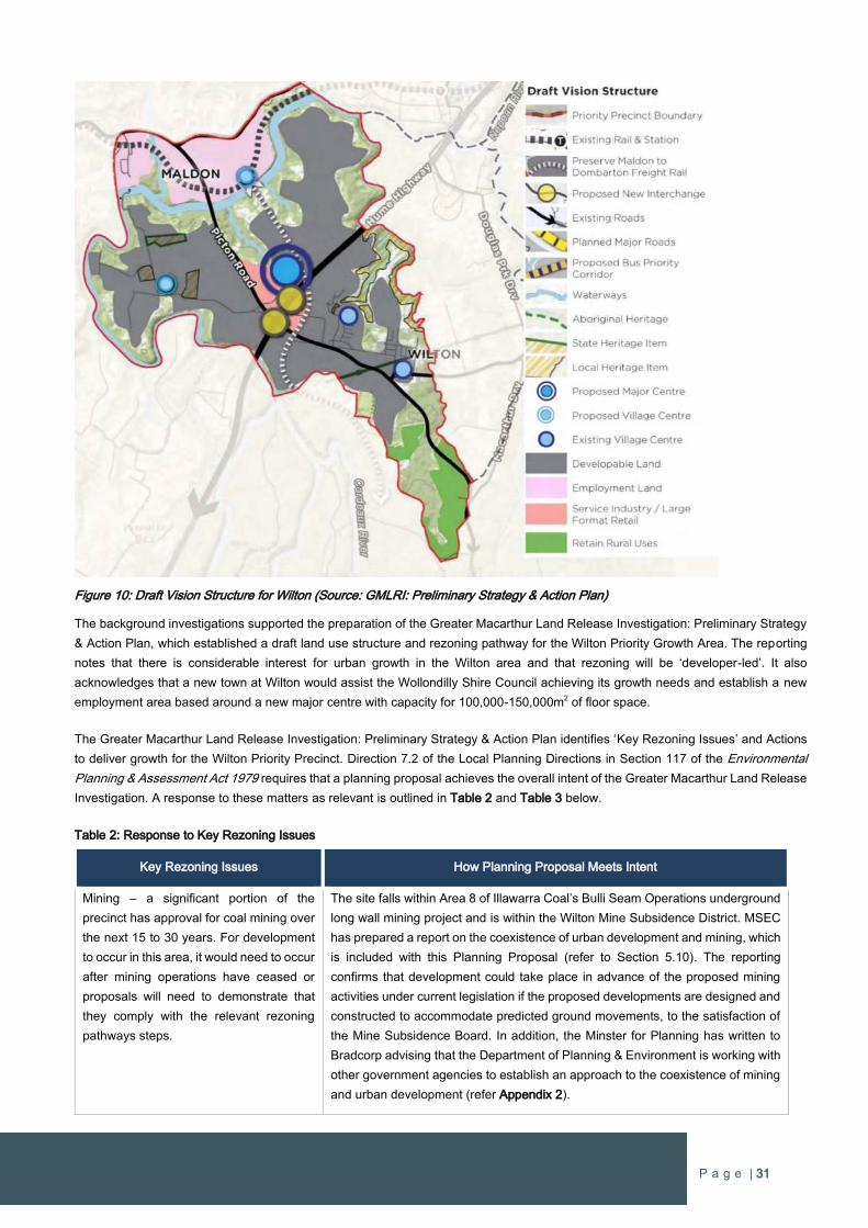
P a g e | 31
Figure 10: Draft Vision Structure for Wilton (Source: GMLRI: Preliminary Strategy & Action Plan)
The background investigations supported the preparation of the Greater Macarthur Land Release Investigation: Preliminary Strategy
& Action Plan, which established a draft land use structure and rezoning pathway for the Wilton Priority Growth Area. The reporting
notes that there is considerable interest for urban growth in the Wilton area and that rezoning will be ‘developer-led’. It also
acknowledges that a new town at Wilton would assist the Wollondilly Shire Council achieving its growth needs and establish a new
employment area based around a new major centre with capacity for 100,000-150,000m2 of floor space.
The Greater Macarthur Land Release Investigation: Preliminary Strategy & Action Plan identifies ‘Key Rezoning Issues’ and Actions
to deliver growth for the Wilton Priority Precinct. Direction 7.2 of the Local Planning Directions in Section 117 of the Environmental
Planning & Assessment Act 1979 requires that a planning proposal achieves the overall intent of the Greater Macarthur Land Release
Investigation. A response to these matters as relevant is outlined in Table 2 and Table 3 below.
Table 2: Response to Key Rezoning Issues
Key Rezoning Issues How Planning Proposal Meets Intent
Mining – a significant portion of the
precinct has approval for coal mining over
the next 15 to 30 years. For development
to occur in this area, it would need to occur
after mining operations have ceased or
proposals will need to demonstrate that
they comply with the relevant rezoning
pathways steps.
The site falls within Area 8 of Illawarra Coal’s Bulli Seam Operations underground
long wall mining project and is within the Wilton Mine Subsidence District. MSEC
has prepared a report on the coexistence of urban development and mining, which
is included with this Planning Proposal (refer to Section 5.10). The reporting
confirms that development could take place in advance of the proposed mining
activities under current legislation if the proposed developments are designed and
constructed to accommodate predicted ground movements, to the satisfaction of
the Mine Subsidence Board. In addition, the Minster for Planning has written to
Bradcorp advising that the Department of Planning & Environment is working with
other government agencies to establish an approach to the coexistence of mining
and urban development (refer Appendix 2).
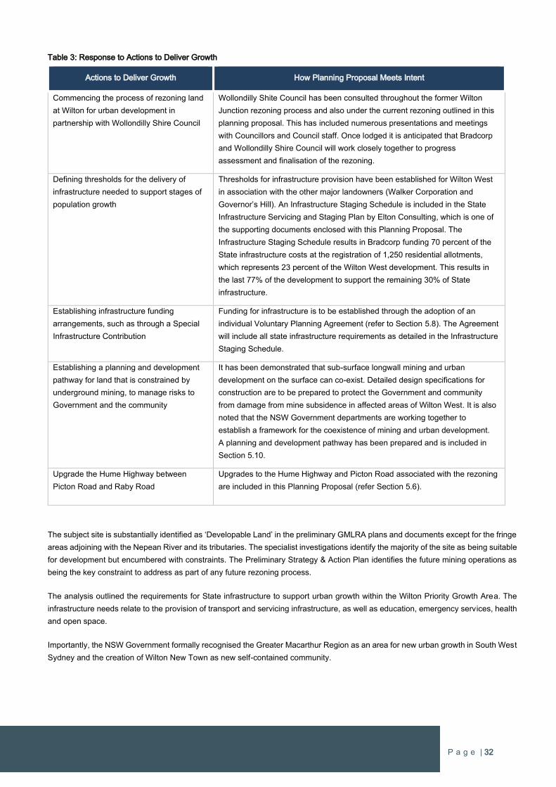
P a g e | 32
Table 3: Response to Actions to Deliver Growth
Actions to Deliver Growth How Planning Proposal Meets Intent
Commencing the process of rezoning land
at Wilton for urban development in
partnership with Wollondilly Shire Council
Wollondilly Shite Council has been consulted throughout the former Wilton
Junction rezoning process and also under the current rezoning outlined in this
planning proposal. This has included numerous presentations and meetings
with Councillors and Council staff. Once lodged it is anticipated that Bradcorp
and Wollondilly Shire Council will work closely together to progress
assessment and finalisation of the rezoning.
Defining thresholds for the delivery of
infrastructure needed to support stages of
population growth
Thresholds for infrastructure provision have been established for Wilton West
in association with the other major landowners (Walker Corporation and
Governor’s Hill). An Infrastructure Staging Schedule is included in the State
Infrastructure Servicing and Staging Plan by Elton Consulting, which is one of
the supporting documents enclosed with this Planning Proposal. The
Infrastructure Staging Schedule results in Bradcorp funding 70 percent of the
State infrastructure costs at the registration of 1,250 residential allotments,
which represents 23 percent of the Wilton West development. This results in
the last 77% of the development to support the remaining 30% of State
infrastructure.
Establishing infrastructure funding
arrangements, such as through a Special
Infrastructure Contribution
Funding for infrastructure is to be established through the adoption of an
individual Voluntary Planning Agreement (refer to Section 5.8). The Agreement
will include all state infrastructure requirements as detailed in the Infrastructure
Staging Schedule.
Establishing a planning and development
pathway for land that is constrained by
underground mining, to manage risks to
Government and the community
It has been demonstrated that sub-surface longwall mining and urban
development on the surface can co-exist. Detailed design specifications for
construction are to be prepared to protect the Government and community
from damage from mine subsidence in affected areas of Wilton West. It is also
noted that the NSW Government departments are working together to
establish a framework for the coexistence of mining and urban development.
A planning and development pathway has been prepared and is included in
Section 5.10.
Upgrade the Hume Highway between
Picton Road and Raby Road
Upgrades to the Hume Highway and Picton Road associated with the rezoning
are included in this Planning Proposal (refer Section 5.6).
The subject site is substantially identified as ‘Developable Land’ in the preliminary GMLRA plans and documents except for the fringe
areas adjoining with the Nepean River and its tributaries. The specialist investigations identify the majority of the site as being suitable
for development but encumbered with constraints. The Preliminary Strategy & Action Plan identifies the future mining operations as
being the key constraint to address as part of any future rezoning process.
The analysis outlined the requirements for State infrastructure to support urban growth within the Wilton Priority Growth Area. The
infrastructure needs relate to the provision of transport and servicing infrastructure, as well as education, emergency services, health
and open space.
Importantly, the NSW Government formally recognised the Greater Macarthur Region as an area for new urban growth in South West
Sydney and the creation of Wilton New Town as new self-contained community.
P a g e | 33
4.5 Wilton New Town
On 29 July 2016 the NSW Minister for Planning published an amendment to the State Environmental Planning Policy (Sydney Growth
Centres) 2006. The State Environmental Planning Policy (Sydney Region Growth Centres) Amendment (Wilton) 2016(SEPP) includes
Wilton as a Priority Growth Area under the Growth Centres SEPP. Therefore, Government has established a clear policy mandate
that Wilton is to be developed for urban purposes to support the forecast delivery of development within the area by 2018 as per the
Greater Macarthur Land Release Investigation
The Priority Growth Area contains over 4,000 hectares of land that is identified for future urban land releases to establish Wilton New
Town. Wilton New Town is projected to accommodate around 16,500 dwellings and substantial areas for commercial and retail
activities. The site has an area of approximately 876 hectares, being the largest landholding, and is projected to deliver around 5,400
new homes, which is a major contribution to Wilton New Town (refer Figure 11).
The next step in the process, which involves the rezoning of the land, is well underway and the purpose of this planning proposal is
to advance the rezoning process as a priority to fulfil the NSW Government’s objectives and time frames for housing delivery. It is
expected that construction of new dwellings may commence in early 2018, with people moving into their homes in the latter part of
2018. This is a threshold moment for Wilton New Town and heralds the next stage of the development of a new community of up to
16,500 homes.
The Government has released a community update “Greater Macarthur & Wilton 2016 and Beyond” which forecasts the delivery of
homes within Wilton by early 2018 and residents by late 2018. The NSW Government establishes the vision for Wilton as:
“We’ll enable places for families to thrive, the environment to be protected and business to flourish. Communities will
be great places to live and work. Infrastructure for new areas will be supplied at no additional cost to government.”
(Greater Macarthur & Wilton: 2016 and Beyond, NSW Department of Planning & Environment)
Bradcorp share the NSW Government’s vision for the Wilton New Town to create a place where people want to live, work, play and
learn that adopts ‘Garden City’ principles and conservation of the environmental qualities of the site.
The NSW Government has undertaken substantial strategic planning and investigations to determine the suitability and capability for
urban development in the Wilton Priority Growth Area to create Wilton New Town. The proposed rezoning is a direct response to the
strategic planning and studies undertaken by the NSW Government to ensure the proper and orderly planning of Wilton for urban
development.
This Planning Proposal is entirely consistent with the Government’s vision and the strategic planning undertaken for the locality.
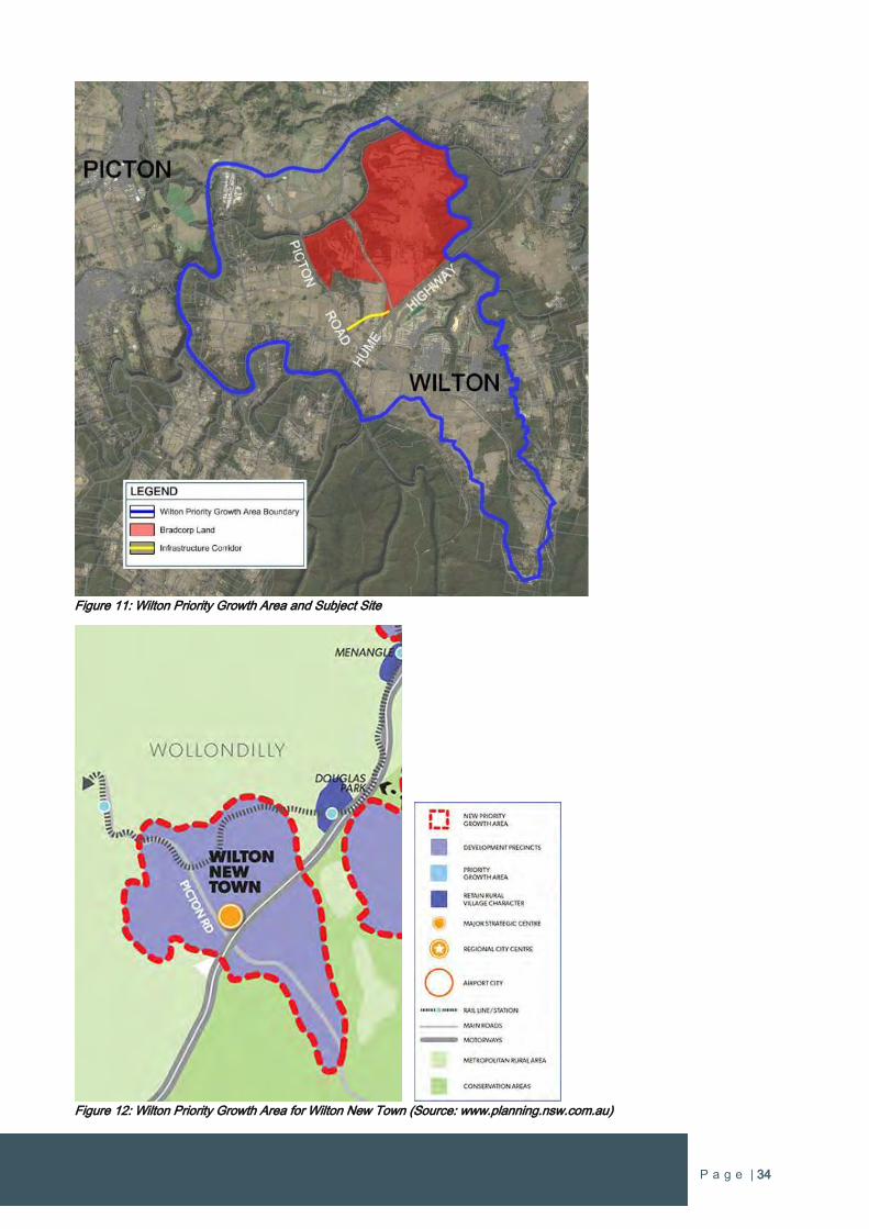
P a g e | 34
Figure 11: Wilton Priority Growth Area and Subject Site
Figure 12: Wilton Priority Growth Area for Wilton New Town (Source: www.planning.nsw.com.au)
P a g e | 35
4.6 Wilton Junction Draft Rezoning, Master-Planning and Site Investigations
4.6.1 Wilton Junction Draft Rezoning
Wilton Junction was the initial planning phase for Wilton New Town, which is located within the larger Wilton Priority Growth Area.
The decision to work towards an integrated Master Plan for Wilton Junction was taken after the State Government invited landowners
in 2011 to nominate sites which might deliver additional housing to address Sydney's housing shortage.
The proponent was one of three landowners working co-operatively with Wollondilly Shire Council, the Department for Planning &
Environment and various Government agencies since April 2012 to deliver a new town at Wilton that will comprising 11,000-13,000
high quality new homes for 30,000-35,000 people. The Wilton Junction Master Plan/rezoning was to support the new community that
was to comprise:
A new major town centre and several neighbourhood centres.
Employment areas to deliver jobs close to home (approx. 11,000 jobs).
Around 11,000 new homes.
A range of community facilities and services.
Road and infrastructure improvements and upgrades.
Director General’s Requirements were issued in May 2013 to establish the requirements for specialist investigations to inform the
rezoning of Wilton Junction. A copy of the Wilton Junction Precinct State Environmental Planning Policy Study Requirements dated
2 May 2013 is included in Appendix 3. All of the required studies have been completed at a cost of $7M, including an infrastructure
strategy. A comprehensive rezoning and infrastructure package was submitted to the Department of Planning & Environment in July
2015. The NSW Government has since established the Wilton New Town Priority Growth Area and has set a framework for
progressing rezoning proposals under a different pathway to the initial stages of the Wilton Junction rezoning process.
4.6.2 Wilton Junction Master Plan
The vision for Wilton Junction is to create a new town that delivers housing diversity and choice with a high level of employment and
service self-sufficiency. This is to be achieved by utilising its locational advantages at the crossroads of the Hume Highway and Picton
Road and building on the exceptional environmental context of the site. This includes integrating the surrounding gorges and bushland
with an open space and pedestrian network that interfaces with the new urban areas of within the future new town.
The Wilton Junction Master Plan was based on detailed site investigations throughout Wilton Junction. The proponent’s land in the
Master Plan is depicted in Figure 13.
The proponent’s land has been master-planned and comprehensively investigated for urban development as part of the initial Wilton
Junction planning process, which comprises most of the land in the Wilton Priority Growth Area. The master-planning and
investigations undertaken for the Wilton Junction project are a valuable resource and remain relevant to informing and justifying this
standalone rezoning proposal on behalf of Bradcorp.
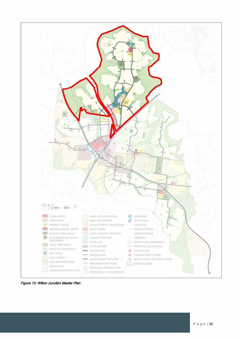
P a g e | 36
Figure 13: Wilton Junction Master Plan
P a g e | 37
4.6.3 Site Investigations
To support the Wilton Junction rezoning proposal numerous technical investigations were undertaken on behalf of the Wilton Junction
Landowner Group. The studies assess the site characteristics, environmental and economic effects, social needs and infrastructure
requirements to ensure that Wilton Junction supports a new community and its needs.
These studies have been submitted to the Department of Planning & Environment whom subsequently distributed the reports to the
relevant Government Departments and agencies for review and comment. The Department of Planning & Environment has since
issued correspondence dated August 2015 confirming that the ‘test of adequacy’ on the reporting has been met subject to minor
modifications for some investigations (refer to Appendix 4).
The following technical studies remain relevant to the current proposal
Masterplan Report
Visual Impact Analysis
Housing Population Projections
Economic Development and Employment Strategy
Social Infrastructure Assessment Report
Ecologically Sustainable Development
Mining Subsidence Report
Contamination Assessment
Ecological Assessment and Environmental Offsets Strategy
Water Strategy Report
Wastewater Strategy Report
Water Cycle Management
Air Quality Impact
Heritage Report
Transport Management Accessibility Plan
Bushfire Assessment
Geotechnical Assessment and Agriculture
Noise Impact Assessment
Valuation for Section 94 Contributions Plan
A summary of the above reports as they relate to the subject site has been provided in Appendix 5 to support this Planning Proposal.
A summary of the key findings that relate to the Wilton West are as follows:
Masterplan Report (Connor Homes):
11,900 additional dwellings (there being approximately 500 in the study area (as at 1 January 2013);
A population of around 35,000 persons; and
More than 11,000 jobs.
Air Quality (SLR):
SLR has identified the key air quality issues for the project and provided mitigation strategies.
The key issues are: Construction activities, Increased traffic volumes (particularly on the Hume Highway and Picton Road)
predicted for 2021 as a result of the development and Early operations of the Bingara Gorge Sewage Treatment Plant
(STP), the proposed Project Wastewater Treatment Plant (WWTP) and associated Sewage Pumping Stations.
P a g e | 38
The assessment outlines that that the existing and proposed surrounding industries will not form a significant constraint on
the development in terms of air quality, where suitable mitigation strategies are implemented.
Bushfire Assessment (Whelans InSites):
The report recommends that asset protection zones (APZs) are used to determine appropriate setbacks for future
residential development.
The recommended APZ varies between 25m and 60m at various locations within the subject site adjoining bushland.
Whelans InSites outline that the extent of the APZ could be varied at the development application stage, subject to a more
detailed site specific assessment.
Contamination Assessment (Douglas Partners):
The potential for significant contamination at the site is low however further investigation of the identified AECs is required.
Remaining potential Areas of Environmental Concern and will require sampling to confirm contamination status.
Subdivision approval within the unexploded ordinance area should be conditional.
Based on the findings of this preliminary contamination assessment, potential groundwater contamination is not
considered to be significant.
It is considered that the site can be rezoned for the proposed Wilton Junction development from a contamination
perspective.
Ecological Assessment & Environmental Offsets Strategy (SLR):
It is not likely that significant adverse impacts would be imposed upon any of the identified threatened species – listed in
either the TSC Act or the EPBC Act.
If vegetation in the Wilton Junction Study Area did constitute the SSTF and/or CPW community, significant areas of that
vegetation would be retained within the Conservation Area at Wilton Junction, transferred to the ownership of the
Environmental Trust and protected, enhanced, managed and celebrated in perpetuity, at no cost to government.
A detailed Environmental Offsets Strategy has been developed for the project.
Ecologically Sustainable Development (Elton Consulting):
The Wilton Junction Landowners Group has also identified a number of best practice sustainability initiatives that will be
implemented at Wilton Junction as part of the vision of a ‘garden city’ for the 21st Century.
The report provides an assessment of the initiatives against the ESD principles and generally demonstrates how the
Wilton Junction Project will meet sustainability objectives.
Economic Development & Employment Strategy (Macroplan Dimasi):
Industries that are predominantly population driven including retail, social infrastructure, health care, education and public
administration, employment will evolve sequentially with population growth.
The report provides employment strategies for sector specific industries including health, education, construction,
transport, postal and warehousing, tourism and recreation and agribusiness.
The success of the strategies will be dependent on: the quality and inventiveness of specific marketing material,
appropriate implementation structures and arrangements and the ongoing ownership and refinement of the initiatives.
Environmental Trust (Elton Consulting):
The Wilton Junction Environmental Trust is a developer led voluntary planning agreement with the State government that
establishes a robust management framework to ensure protection of bio-diversity and culturally significant sites and
provision for the on-going management of these resources.
P a g e | 39
Geotechnical Assessment (Douglas Partners):
The investigation addressed the site’s geotechnical surface and subsurface conditions, slope instability risk potential, soil
erosion risks, soil salinity and geotechnical development constraints.
Douglas Partners outline in their report that the assessment undertaken did not identify any issue that would preclude the
rezoning of the Wilton Junction site for urban development.
Additional investigations will be required as the project progresses.
Heritage Report (Kayandel Archaeological Service):
The assessment identified a number of Aboriginal and Historic heritage items within the Wilton West area.
The report concludes that impacts upon items of Aboriginal heritage or items of historic heritage are not sufficient as to
prevent the rezoning application currently proposed.
The report confirms the level of investigation and enquiry is sufficient to provide for an assessment of the rezoning
proposal to be undertaken.
A number of recommendations are provided for the rezoning and for the development application stage. These include
obtaining an Aboriginal Heritage Impact Permit.
Housing and Population Projections (Macroplan Dimasi):
The likely demographic characteristics and housing needs of the new township of Wilton Junction include:
A future population of 34,955 at Wilton Junction by 2041
A potential for greater market share to be achieved from a master-planned community offering;
A dominance of family households, with a marginally greater representation of couple families without children when
compared to south-west Sydney; and
A likely dominance of detached housing at Wilton Junction
Infrastructure Servicing & Staging Plan (BG&E):
The Infrastructure Servicing and Staging Plan provides an overview of the infrastructure requirements to service the Wilton
Junction development.
The estimated cost to provide all required infrastructure (roads, potable water, waste water, electricity and social
infrastructure) triggered by Wilton Junction is $253,384,738.
A Voluntary Planning Agreement is identified as the best means of securing funding and delivery of infrastructure.
Mine Subsidence (MSEC):
The site falls within Area 8 of Illawarra Coal’s Bulli Seam Operations underground long wall mining project and therefore
the entirety of Wilton Junction lies within the Wilton Mine Subsidence District (MSD).
The report outlines that, from a planning perspective that the development of the Wilton Junction site could take place in
advance of the proposed mining activities under current legislation if the proposed developments are designed and
constructed to accommodate predicted ground movements, to the satisfaction of the Mine Subsidence Board.
In MSEC’s opinion, it is unnecessary to delay development until after coal resources have been mined.
Developers will need to engage with the Mine Subsidence Board (MSB), and seek approval for the development from the
MSB.
Noise and Vibration Assessment (Atkins Consulting):
The assessment outlines the noise generating infrastructure impacting the site are:
o Existing roads - Hume Highway and Picton Road.
o Existing Rail – Southern Railway Line between Sydney and Goulburn.
o Proposed rail - Maldon Dombarton Rail Corridor.
P a g e | 40
Noise and vibration mitigation strategies will be required, in accordance with the Infrastructure SEPP. The mitigation
strategies include:
Negotiations with proponents of the rail infrastructure developments.
Sub-division planning including building orientations, layouts, set-backs.
Buffer zones along infrastructure corridors.
Social Infrastructure Assessment (Elton Consulting):
A recommended provision of open space has been provided based on the standard calculation of 2.83ha/1000 population. The
report recommends 75ha of open space be provided generally with a 50:50 apportionment between formal and active open
space.
Elton have recommended district and regional as well as local level facilities for Wilton Junction.
Transport Management & Accessibility Plan (Parsons Brickenhoff):
A detailed suite of traffic assessments have been undertaken utilising the TfNSW Sydney Strategic Transport Model (STM), an
AIMSUN Mesoscopic model for the Wilton Junction study area, and isolated intersection SIDRA models.
Major road upgrades outlined in the report include:
Upgrade to the Hume Highway and Picton Road Interchange.
Provision of a new internal north-south road grade separated from Picton Road at a point 400m west of Pembroke
Road.
A new intersection on Picton Road, at Wilton Park Road (which will be realigned) with signalised access into the
development.
The report also provides recommendations in relation to public and active transport for Wilton Junction.
Visual Analysis Report (Connor Homes):
Key view-scapes from the site are identified in the report and focus on the external views to the Razorback Mountains, the
Southern Highlands, to the west to Maldon and to the east to distant industry and St Mary’s Towers.
Key recommendations focus on the need to retain key ridgelines and hills as open areas where possible and practicable.
Waste Management Strategy (Eco-Sustainable):
The Waste Strategy prepared by Eco-Sustainable provides strategic consideration of waste impacts to assist in minimising the
generation of waste and maximising the recovery of resources.
The report splits the management of waste for the project into three principal phases – Land Clearing and Civil Works,
Construction and ongoing use.
Waste Water Strategy (MWH):
MWH’s waste water strategy provides estimated capital costs and delivery staging for provision of wastewater servicing
infrastructure.
This costs include provision of a Membrane Bio-Reactor (MBR) wastewater treatment plant with tertiary media filters located
near the existing Bingara Gorge STP and a pressure sewer network with individual pots and pumps installed on each property.
Waste Cycle Management (J Wyndham Prince):
The Water Cycle Management Strategy proposed for the site consists of a treatment train including on lot treatment, street
level treatment and subdivision / development treatment measures. The structural elements proposed for the development
include:
o Proprietary GPT units at each stormwater discharge point.
o Approximately seventy-six (76) proposed bio-retention raingardens of total area 149,900 m².
o One (1) proposed regional detention basin on-line within Allens Creek (approximate total volume 35,000 m3).
o A recycled Water Management System which incorporates: an STP, a cascading raingarden system, two
treatment/evaporation lakes.
P a g e | 41
Water Strategy (MWH):
Sydney Water were engaged in developing the strategy.
MWH outline that the estimated capital cost of providing the trunk water servicing infrastructure is $18.9 million excluding
reticulation pipework costs.
State Infrastructure Servicing and Staging Plan (Elton Consulting):
Elton Consulting have summarised the Infrastructure Servicing and Staging Plan for Wilton Junction and outlined the Proponents
Funding Offer in relation to the scope, cost, funding and delivery of the infrastructure required at Wilton Junction.
The State Infrastructure items comprise roads, public transport and social facilities, and
Water, waste water and utility services will be covered by the Proponents through commercial agreements with service
providers.
None of the above findings have been determined to impede the rezoning of the site. The associated technical studies provide
recommendations for future development and appropriate mitigation measures for any potential impacts identified. All technical
studies confirm that rezoning the site can proceed without the need for further assessment.
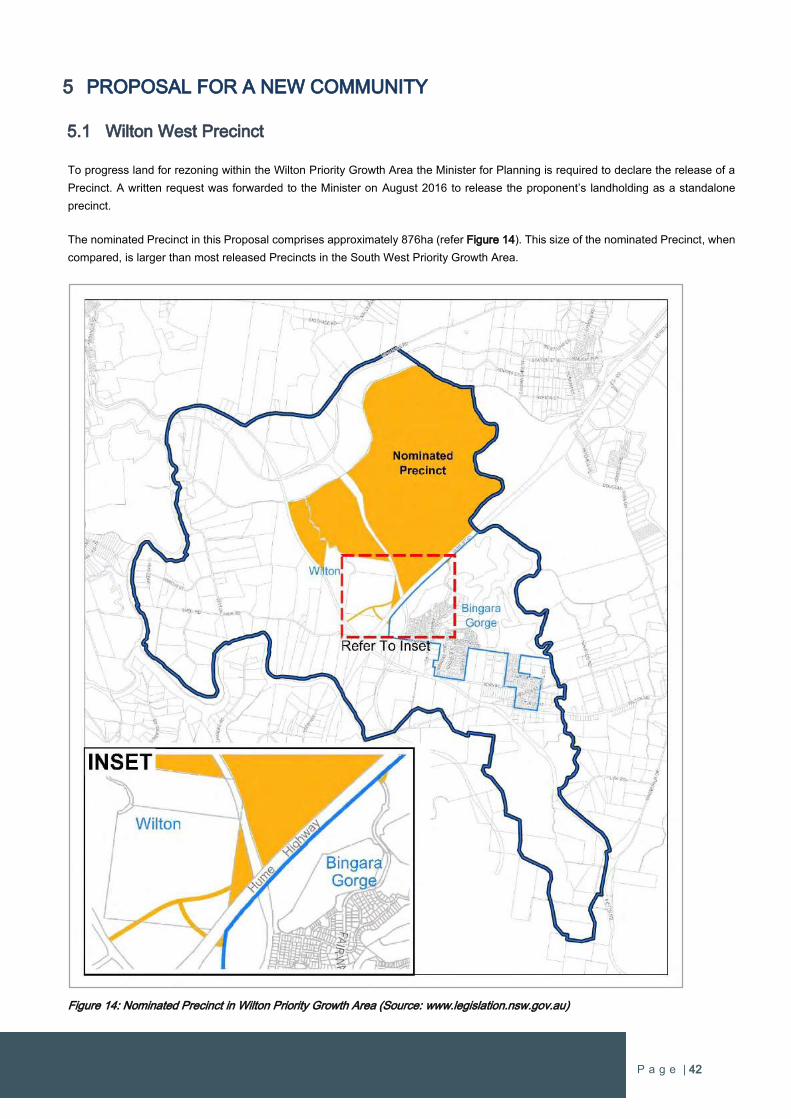
P a g e | 42
5 PROPOSAL FOR A NEW COMMUNITY
5.1 Wilton West Precinct
To progress land for rezoning within the Wilton Priority Growth Area the Minister for Planning is required to declare the release of a
Precinct. A written request was forwarded to the Minister on August 2016 to release the proponent’s landholding as a standalone
precinct.
The nominated Precinct in this Proposal comprises approximately 876ha (refer Figure 14). This size of the nominated Precinct, when
compared, is larger than most released Precincts in the South West Priority Growth Area.
Figure 14: Nominated Precinct in Wilton Priority Growth Area (Source: www.legislation.nsw.gov.au)
P a g e | 43
To give context in relation to the size of the nominated Precinct, a comparison with other released Precinct areas is listed below.
Austral & Leppington North Precincts 2,025 ha
Oran Park Precinct 1,119 ha (approx. 200ha dedicated as heritage curtilage)
Wilton West Precinct 876 ha
Edmondson Park Precinct 827 ha
Leppington Precinct 655 ha
Turner Road Precinct 536 ha
East Leppington Precinct 465 ha
Catherine Fields Part Precinct 318 ha
The nominated Precinct is ranked third in size of the Precincts released in the South West Priority Growth Area and is similar in area
to the Edmondson Park Precinct, which provided for around 6,000 new homes and also includes a significant area dedicated to
conservation lands.
5.2 Site Analysis
There are a range of attributes and characteristics that influence how the site can be developed. The site has natural physical attributes
such as topography, native vegetation and fauna, and rivers and waterways that form consideration in the urban design and
preservation of the natural environment. There are also views and vistas to surrounding elevated areas, in particular the northwest,
which provide a stunning backdrop to the site.
There are also other site considerations that influence the design of urban development within the site or are matters that need to be
addressed as part of planning and delivering development on the site. These matters are summarised as follows:
Aboriginal heritage – scarred trees, rock scatters, significant sites and objects.
Contamination – remediating and managing areas of environmental concern.
Bushfire – implementing Asset Protection Zones, managing bushfire risk.
Infrastructure – managing existing and future infrastructure, transmission lines, fibre optic cables.
Noise & vibration – mitigating potential adverse impacts from existing and future major roads and rail.
Services – connections to essential services, provision of new servicing infrastructure.
Traffic & transport – connecting to external transport routes.
Also, where appropriate, solutions are provided indicating how the master plan is able to integrate the opportunities in the design, and
mitigate the issues.
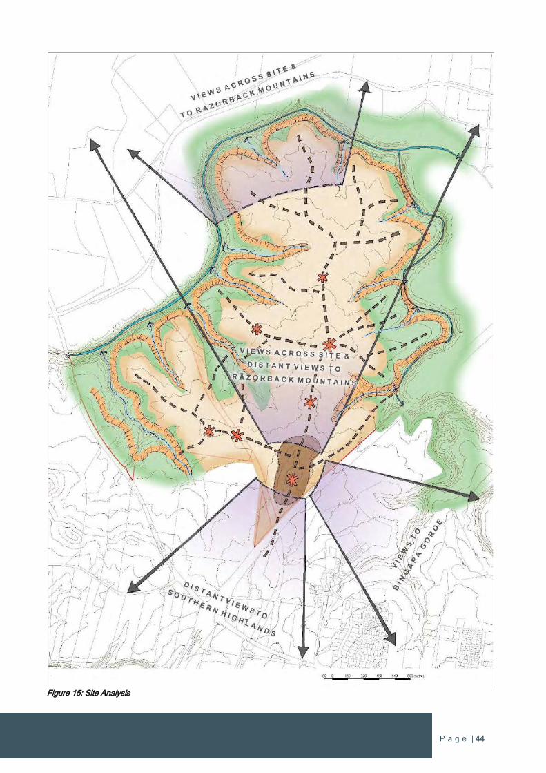
P a g e | 44
Figure 15: Site Analysis
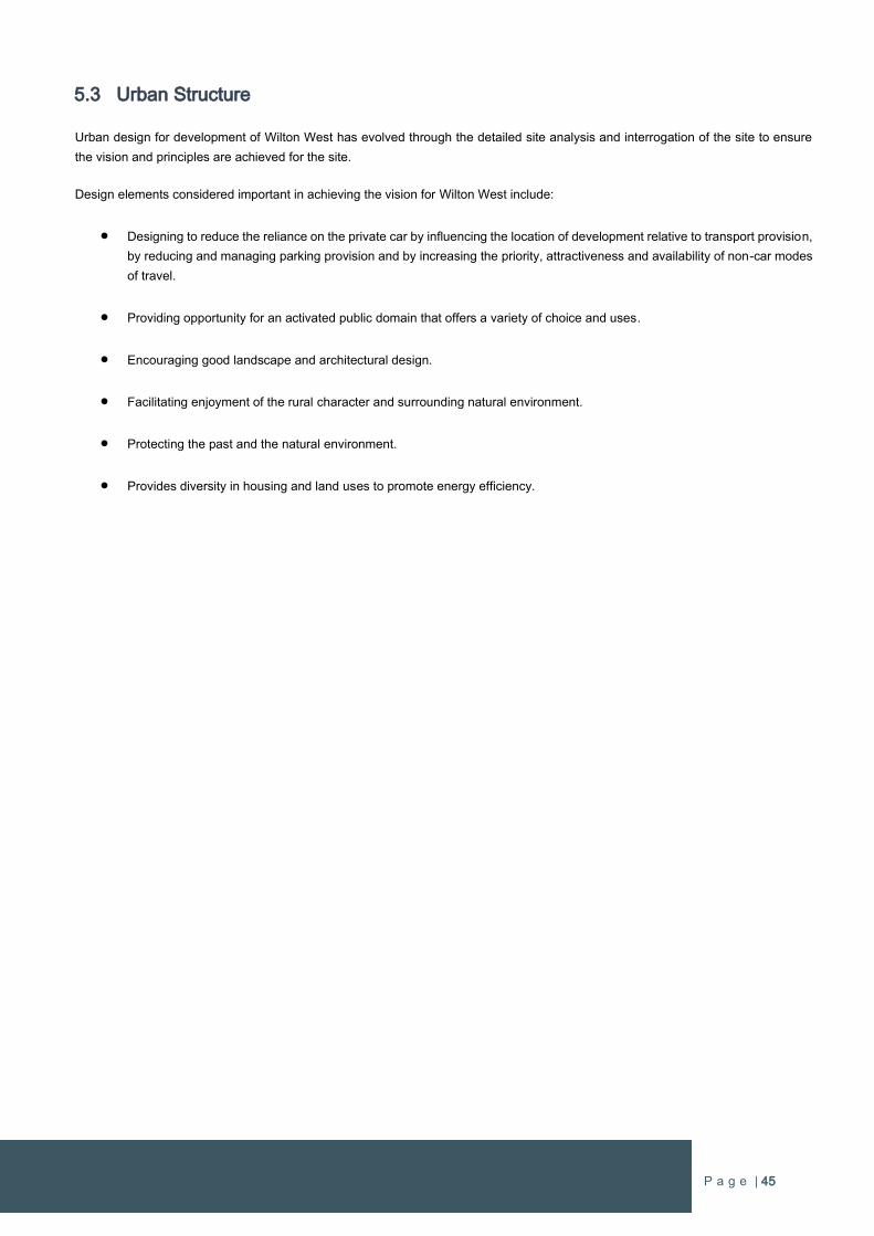
P a g e | 45
5.3 Urban Structure
Urban design for development of Wilton West has evolved through the detailed site analysis and interrogation of the site to ensure
the vision and principles are achieved for the site.
Design elements considered important in achieving the vision for Wilton West include:
Designing to reduce the reliance on the private car by influencing the location of development relative to transport provision,
by reducing and managing parking provision and by increasing the priority, attractiveness and availability of non-car modes
of travel.
Providing opportunity for an activated public domain that offers a variety of choice and uses.
Encouraging good landscape and architectural design.
Facilitating enjoyment of the rural character and surrounding natural environment.
Protecting the past and the natural environment.
Provides diversity in housing and land uses to promote energy efficiency.
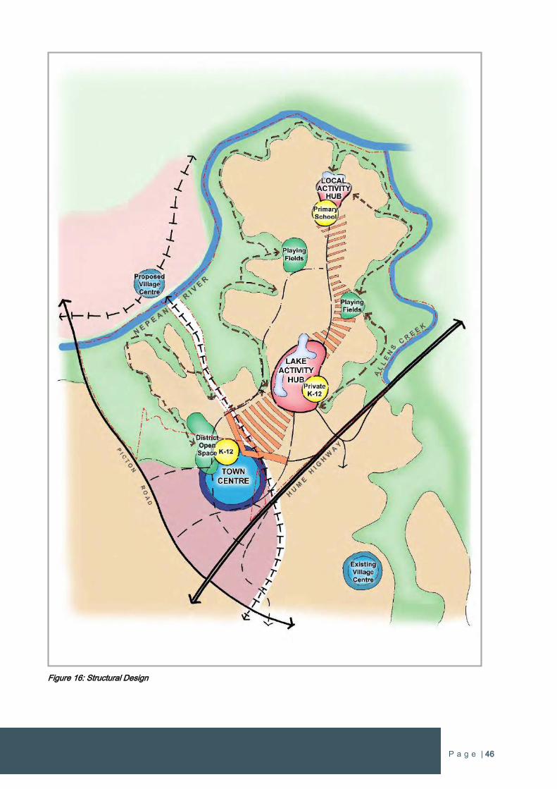
P a g e | 46
Figure 16: Structural Design
P a g e | 47
5.4 Design Elements
5.4.1 Movement and Connectivity
The transport network for Wilton West is formed on two major roads orientated north-south to move traffic from the main connections
to Picton Road and a dedicated off-ramp from the Hume Highway, which connects with the main north-south sub-arterial road on the
Governors Hill land to the south of the site. There is also a second dedicated off-ramp at the existing bridge crossing that will provide
a direct connection to Wilton West for southbound traffic on the Hume Highway. This connection will also enable direct access to
Bingara Gorge. There is also an on-ramp to the Hume Highway from Wilton West immediately to the north of the Maldon Dombarton
Rail Link. This on-ramp and the two off-ramps provide alternative access routes to the Hume Highway/Picton Road interchange, which
is a dedicated heavy freight route connecting to the Wollongong Region.
The major north-south roads are connected with higher order east-west roads to ensure the road structure enables the site to be well
connected internally and with the surrounding residential areas of Wilton New town. This enables all local residential streets to obtain
easy access to the higher order road network to ensure convenient and efficient travel from their home to local shops and services
within Wilton New Town and external travel to places further afield.
The Urban Structure Plan promotes modal choice for the future residents and employees. Planning of the transportation network has
ensured that each mode of transport is attractive for users of all ages and abilities and the various modes are well-integrated.
Key elements of the road network shown on the Urban Structure Plan include:
Innovative urban design that creates streets for people rather than just roads for cars.
Roads, pedestrian and cycle paths, open spaces and community facilities seamlessly connected within Wilton West and to
the surrounding areas.
A street pattern and orientation of lots that maximises open vistas to surrounding hills, the Razor Back Mountains and internal
localised views.
The road framework provides a comprehensive structure for establishing logical neighbourhoods that are well connected to
surrounding areas.
The road layout is a simple and legible network that responds to the site and its topography.
The road hierarchy is carefully designed to maximise legibility, permeability and accessibility.
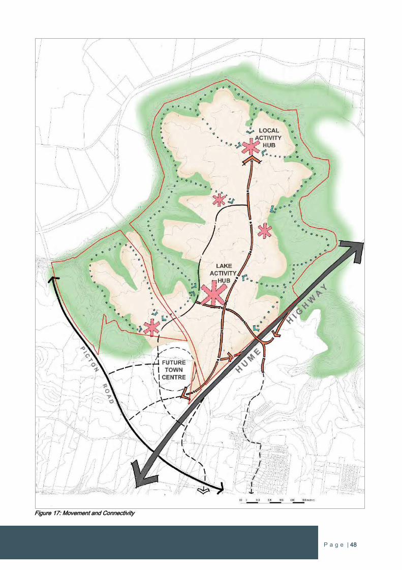
P a g e | 48
Figure 17: Movement and Connectivity
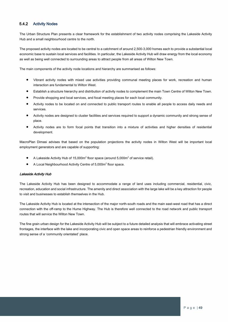
P a g e | 49
5.4.2 Activity Nodes
The Urban Structure Plan presents a clear framework for the establishment of two activity nodes comprising the Lakeside Activity
Hub and a small neighbourhood centre to the north.
The proposed activity nodes are located to be central to a catchment of around 2,500-3,000 homes each to provide a substantial local
economic base to sustain local services and facilities. In particular, the Lakeside Activity Hub will draw energy from the local economy
as well as being well connected to surrounding areas to attract people from all areas of Wilton New Town.
The main components of the activity node locations and hierarchy are summarised as follows:
Vibrant activity nodes with mixed use activities providing communal meeting places for work, recreation and human
interaction are fundamental to Wilton West.
Establish a structure hierarchy and distribution of activity nodes to complement the main Town Centre of Wilton New Town.
Provide shopping and local services, and focal meeting places for each local community.
Activity nodes to be located on and connected to public transport routes to enable all people to access daily needs and
services.
Activity nodes are designed to cluster facilities and services required to support a dynamic community and strong sense of
place.
Activity nodes are to form focal points that transition into a mixture of activities and higher densities of residential
development.
MacroPlan Dimasi advises that based on the population projections the activity nodes in Wilton West will be important local
employment generators and are capable of supporting:
A Lakeside Activity Hub of 15,000m2 floor space (around 5,000m2 of service retail).
A Local Neighbourhood Activity Centre of 5,000m2 floor space.
Lakeside Activity Hub
The Lakeside Activity Hub has been designed to accommodate a range of land uses including commercial, residential, civic,
recreation, education and social infrastructure. The amenity and direct association with the large lake will be a key attraction for people
to visit and businesses to establish themselves in the Hub.
The Lakeside Activity Hub is located at the intersection of the major north-south roads and the main east-west road that has a direct
connection with the off-ramp to the Hume Highway. The Hub is therefore well connected to the road network and public transport
routes that will service the Wilton New Town.
The fine grain urban design for the Lakeside Activity Hub will be subject to a future detailed analysis that will embrace activating street
frontages, the interface with the lake and incorporating civic and open space areas to reinforce a pedestrian friendly environment and
strong sense of a ‘community orientated’ place.
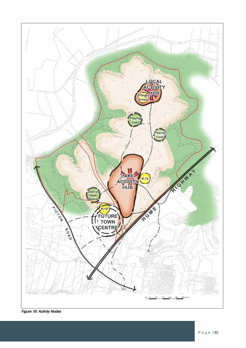
P a g e | 50
Figure 18: Activity Nodes
P a g e | 51
Local Neighbourhood Activity Centre
A Local Neighbourhood Activity Centre incorporating a small to medium supermarket and speciality stores is proposed in the northern
portion of the site at the end of the main major north-south road in the site, which will form a bus route central to the site.
The Local Neighbourhood Activity Centre is assessed to support around 5,000m2 of floor space to provide local retail and services to
the northern catchment of the Wilton West community.
A small scale centre has been centrally positioned on the interface with the Nepean River to bring added amenity and connection with
the setting and nature, which are important underlying objectives for Wilton West.
5.4.3 Local Neighbourhoods
The Urban Structure Plan provides a defined urban neighbourhood structure of eight neighbourhoods that are formed on the natural
attributes of the site and fundamental planning principles of walkable catchments centred on centres, parks, bus stops, shops,
community facilities and schools.
The neighbourhood framework responds to physical attributes of the site in conjunction with the movement network and key physical
and social attractors. The neighbourhoods are designed to:
Utilise and celebrate the natural attributes of topography, vegetation and unique landscape features in each local
neighbourhood.
Incorporate public spaces that are safe and accessible for each local neighbourhood.
Provide access to public transport.
Exhibit a strong character and identity to foster a strong sense of place.
Each neighbourhood is proposed to be individual and unique as a result of detailed urban design that builds on the opportunities that
each neighbourhood offers in relation to landscape, natural features, introduced elements, road patterns and land use
interrelationships.
The following is a summary of residential neighbourhoods throughout Wilton West:
A diverse dwelling mix, catering for various households, including older people, single people and families to form a genuine
community.
Attention to urban design detail to ensure that streetscapes maintain pleasant tree lined avenues for people to safely walk
and meet people within their neighbourhood.
Leadership in housing to demonstrate the quality and diversity of housing types to create a ‘spirituality’ in each
neighbourhood.
Higher density housing types around activity nodes and amenity spaces.
Contemporary housing options that are located close to open parkland areas.
Urban densities rather than suburban densities are promoted to offer diversity of dwelling types and achieve a socio-economic mix.
The activity nodes will support density and diversity in housing to ensure that each centre has a vibrant mix of land use activities.
The higher density development will take the form of attached dwellings, semi-detached housing and townhouses. Dwelling density
will also be located adjacent to and within close proximity to high amenity and focal areas, in particular open space and public transport
routes. Dwelling densities will graduate out from the higher density areas to lower dwelling densities in the residential neighbourhoods.
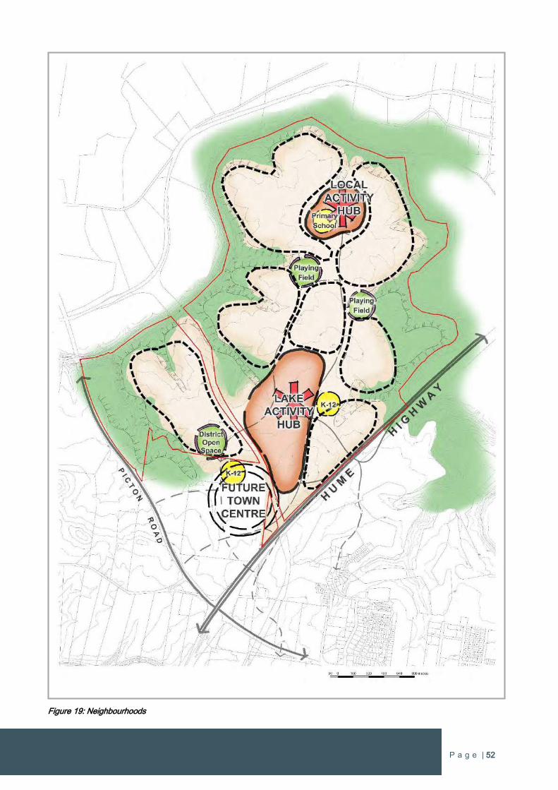
P a g e | 52
Figure 19: Neighbourhoods
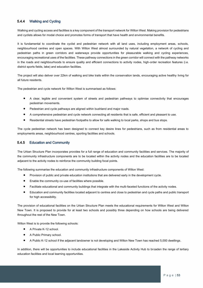
P a g e | 53
5.4.4 Walking and Cycling
Walking and cycling access and facilities is a key component of the transport network for Wilton West. Making provision for pedestrians
and cyclists allows for modal choice and promotes forms of transport that have health and environmental benefits.
It is fundamental to coordinate the cyclist and pedestrian network with all land uses, including employment areas, schools,
neighbourhood centres and open spaces. With Wilton West almost surrounded by natural vegetation, a network of cycling and
pedestrian paths in green corridors and waterways provide opportunities for pleasurable walking and cycling experiences,
encouraging recreational uses of the facilities. These pathway connections in the green corridor will connect with the pathway networks
in the roads and neighbourhoods to ensure quality and efficient connections to activity nodes, high-order recreation features (i.e.
district sports fields, lake) and education facilities.
The project will also deliver over 22km of walking and bike trails within the conservation lands, encouraging active healthy living for
all future residents.
The pedestrian and cycle network for Wilton West is summarised as follows:
A clear, legible and convenient system of streets and pedestrian pathways to optimise connectivity that encourages
pedestrian movements.
Pedestrian and cycle pathways are aligned within bushland and major roads.
A comprehensive pedestrian and cycle network connecting all residents that is safe, efficient and pleasant to use.
Residential streets have pedestrian footpaths to allow for safe walking to local parks, shops and bus stops.
The cycle pedestrian network has been designed to connect key desire lines for pedestrians, such as from residential areas to
employments areas, neighbourhood centres, sporting facilities and schools.
5.4.5 Education and Community
The Urban Structure Plan incorporates provides for a full range of education and community facilities and services. The majority of
the community infrastructure components are to be located within the activity nodes and the education facilities are to be located
adjacent to the activity nodes to reinforce the community building focal points.
The following summarise the education and community infrastructure components of Wilton West:
Provision of public and private education institutions that are delivered early in the development cycle.
Enable the community co-use of facilities where possible.
Facilitate educational and community buildings that integrate with the multi-faceted functions of the activity nodes.
Education and community facilities located adjacent to centres and close to pedestrian and cycle paths and public transport
for high accessibility.
The provision of educational facilities on the Urban Structure Plan meets the educational requirements for Wilton West and Wilton
New Town. It is proposed to provide for at least two schools and possibly three depending on how schools are being delivered
throughout the rest of the New Town.
Wilton West is to provide the following schools:
A Private K-12 school.
A Public Primary school.
A Public K-12 school if the adjacent landowner is not developing and Wilton New Town has reached 5,000 dwellings.
In addition, there will be opportunities to include educational facilities in the Lakeside Activity Hub to broaden the range of tertiary
education facilities and local learning opportunities.
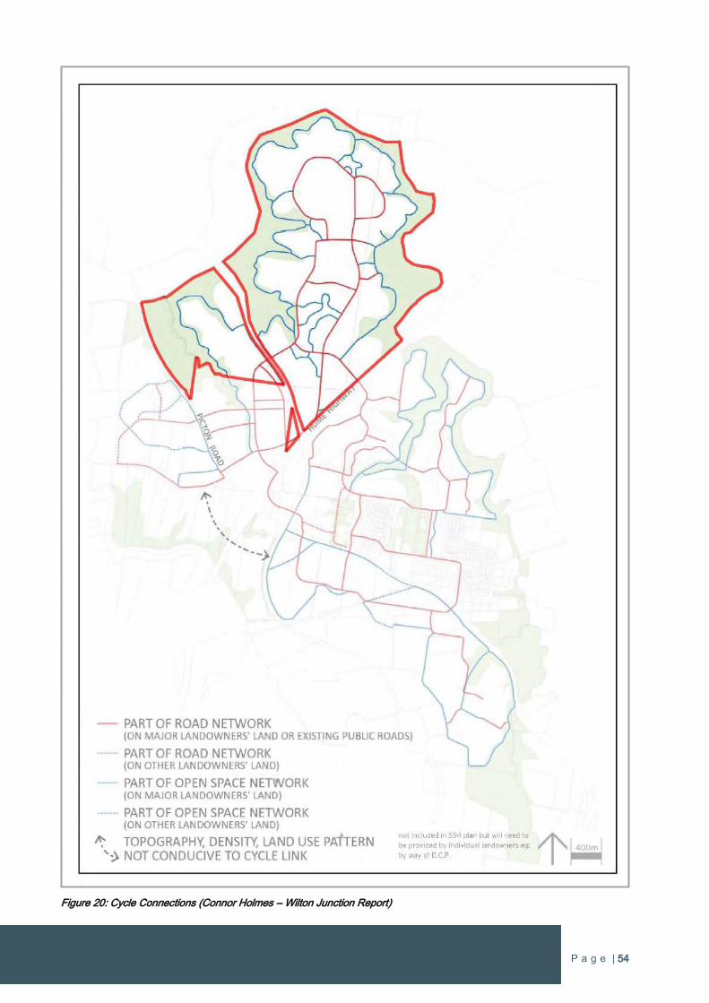
P a g e | 54
Figure 20: Cycle Connections (Connor Holmes – Wilton Junction Report)
P a g e | 55
5.4.6 Open Space and Recreation
A variety of open space areas and recreation spaces are to be incorporated into Wilton West to ensure a diverse range of activities
for everyone to use and enjoy, with over 47 hectares of open space provided within the community.
The large lake is a principal contributor for recreation and open space as it provides opportunities for a range of activities. The
landscaped edge of the lake includes pathways complemented by picnicking facilities, play areas, public fitness equipment. People
will be able to jog, walk and cycle around the lake that will be an impressive feature of high aesthetical appeal.
There are also two active sports fields facilities that are central to the Wilton West community and are located on major road
connections. Both site also interface with the bushland surrounding Wilton West to reinforce the setting and connections with nature.
Numerous local parks are located in areas with unique landscape features including waterways, rock outcrops and trees. This local
parks are to be connected with a network of pathways within the bushland that provide active and passive recreation options for
people wanting to enjoy the bushland.
The following is a summary of the open space and recreation elements of the Urban Structure Plan:
Providing a broad range of active and passive recreation options that promote and nurture community health and wellbeing
in the immediate and long term.
All recreation areas and local parks linked landscaped paths and riparian areas and bushland.
Road alignments maximise views of open space and conservation areas.
Protection of existing high quality trees in open space areas.
A diversity of passive and active recreation spaces that encourage physical and mental activity.
Local parks maximise the connections both visually and physically between riparian areas and bushland.
Local parks bound by roads and reinforced by buildings for safety, accessibility and legibility.
Connected open space corridors for fauna movement.
A range of open space providing passive and active recreation use, with parks having kick-about and informal ball areas.
Memorable and walkable bushland trails that are well connected and provide local, district and regional circuits.
Open space located on pedestrian and cycle ways for people to easily and safely access recreation areas.
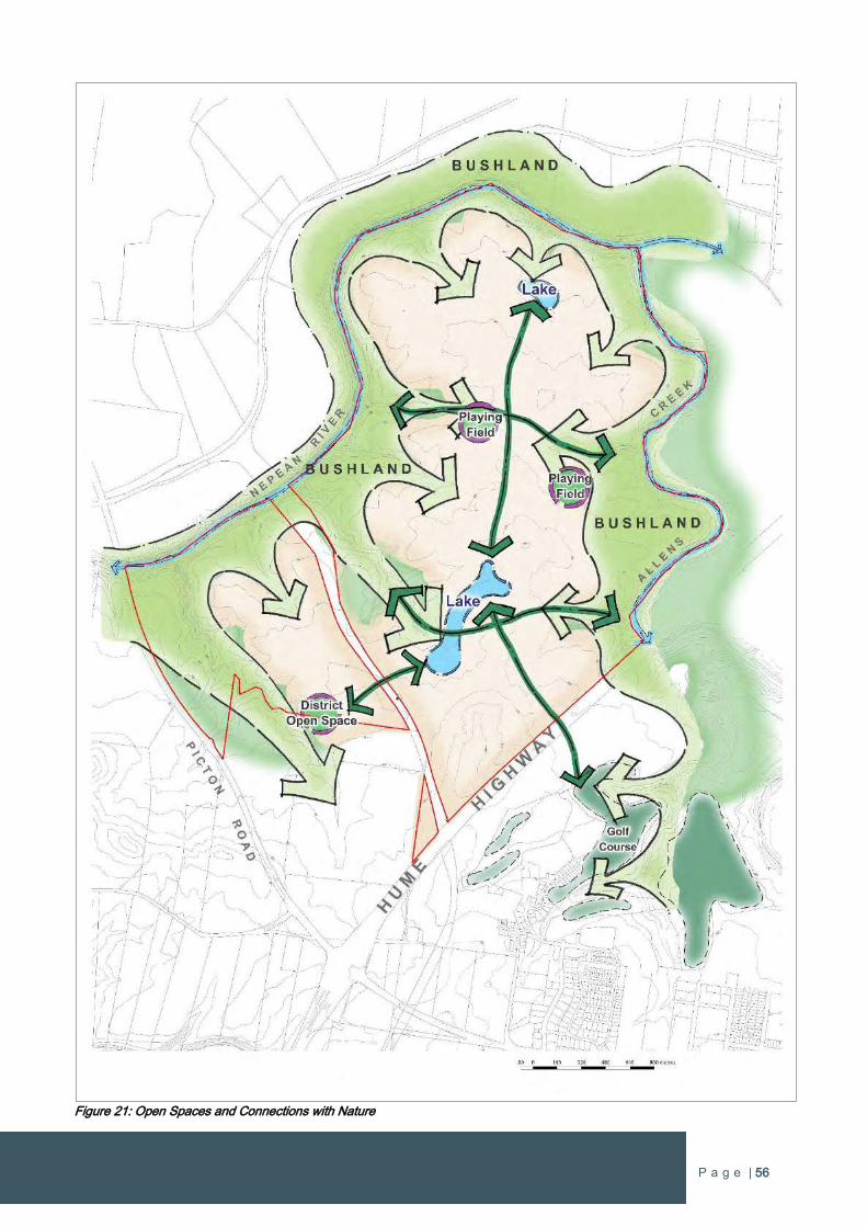
P a g e | 56
Figure 21: Open Spaces and Connections with Nature
P a g e | 57
5.5 Rezoning the Site to Enable Infrastructure Delivery
The rezoning is a standalone proposal that seeks to rezone the entire Wilton West Precinct within the Wilton Priority Growth Area.
The proposal incorporates a significant amount of State and local infrastructure to support Wilton New Town and the Wilton West will
support a significant portion of the population due to its scale and size relative to the other holdings in the Growth Area.
The delivery of urban growth in the New Town will be complemented by the delivery of State infrastructure, in particular the delivery
of new transport infrastructure. Rezoning the whole Wilton West Precinct is necessary to provide the certainty to forward fund the
State infrastructure as proposed.
Rezoning the entire Wilton West Precinct will enable the commitments and certainty to providing State infrastructure not just for the
Wilton West but for the future residents of the entire Wilton New Town. Fundamentally, the proponent is assuming the development
risk by forward funding the State infrastructure (70% of infrastructure funded at 23% of development) and it is therefore essential that
the entire site to be rezoning to underwrite these commitments.
5.6 Infrastructure Provision
A proponent infrastructure offer incorporating the three major landowners (Bradcorp, Walker Corporation and Governor’s Hill) was
presented to the Government in July 2015 as part of the Wilton Junction rezoning. The total value of the Wilton Junction proponent
offer was $178.5M, which includes a further $45M of additional funds requested by the Department of Planning & Environment that
does not have a nexus to Wilton New Town (Wilton Junction component). The offer also included land dedicated for conservation
purposes.
The offer was structured so infrastructure could be provided individually by the three largest landowners in the Wilton PGA (excluding
Lend Lease) given the critical mass generated by their respective projects. Various infrastructure items were allocated to these
landowners based on the development capacity of each respective individual project.
It is proposed to provide certain State infrastructure early to ensure delivery will always be ahead of demand throughout the life of the
project. Bradcorp’s schedule for infrastructure delivery will result in over 70% of the State infrastructure requirements being delivered
when only 23% of the urban development has occurred. This results in the last 77% of the development to support the remaining 30%
of State infrastructure.
Contributions for State road infrastructure that have been established for Wilton Junction protects the free flow of freight corridor and
enables internal traffic movements which do not interfere with those on the Hume Hwy and Picton Road. There are also requirements
to fund and deliver essential internal connector roads on land under various ownerships to ensure the road network for Wilton New
Town functions properly and does not create issue with State roads. This will ensure performance improvement to the Interchange
by separating the traffic generated from Wilton New Town and the heavy freight vehicles traveling between the Wollongong and
Sydney regions. These works also include the provision of a pedestrian bridge over the Hume Highway to enable a pedestrian and
cycling transport connection to Bingara Gorge. Revenue generated from the Wilton West population is needed so as to ensure these
high cost infrastructure items can be delivered.
Education requirements were determined as part of the Wilton Junction Master Plan investigations and established that a Public K-
12 school and two primary schools are required. The site has a Private K-12 school and is assigned to provide one of the primary
schools. The proponent has a contracted provider for the Private K-12 school and the primary school in the north of the site will be
delivered in the medium to long term. In the event that there is a demand to establish a Public K-12 school, Bradcorp will commit to
delivering this essential educational infrastructure item once the 5,000th dwelling is constructed, which is the dwelling threshold stated
by the Department of Education.
Infrastructure will be provided to support at least 5,400 new dwellings. It is noted that the other two major landowners (Walker
Corporation and Governors Hill) will also have capacity to deliver major State infrastructure in the Wilton New Town. It is anticipated
that the respective infrastructure items will be allocated as determined during the Wilton Junction Master Plan/rezoning process. It is
expected that the smaller landholdings located within the Wilton PGA will contribute through the Special Infrastructure Contribution
(SIC).

P a g e | 58
5.7 Direct Access Ramp
An opportunity exists to improve connectivity with Wilton New Town by incorporating an additional off-ramp from the Hume Highway
that provide a direct access route to the northern urban areas of Bingara Gorge and Wilton West. The additional off-ramp from the
Hume Highway has evolved out of the planning undertaken during the Wilton Junction planning process. The new direct access
arrangement establishes a new strategic road connection directly off the Hume Highway that will reduce traffic on the exiting Hume
Highway/Picton Road interchange and increase options for accessing Wilton West and the broader Wilton New Town.
The proposed on-ramp within Wilton West would also be delivered to ensure easy access back onto the Hume Highway in the
northbound direction. This will deliver a well-connected road network that achieves a host of wide-ranging benefits to serve the Wilton
New Town community as it grows. The key traffic connections off and on the Hume Highway are illustrated in Figure 22. A detailed
concept plan of the direct access off-ramp is shown in Figure 23.
NSW Roads & Maritime Services (RMS) has reviewed the direct access ramp proposal and has advised in writing that they “have no
in-principle objection, from a road design perspective, to the direct southbound exit ramp proposed to the north of the existing Niloc
Bridge which crosses the Hume Motorway”. A copy of the correspondence from the RMS is include in Appendix 6. The RMS also
requested that more detailed analysis will need to be completed and considered by relevant parties.
Figure 22: Key Access Routes for Northern Wilton New Town
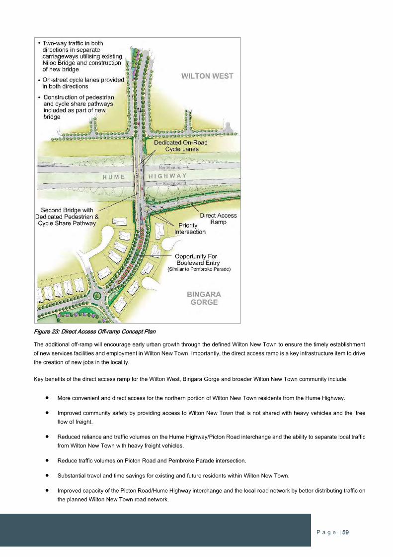
P a g e | 59
Figure 23: Direct Access Off-ramp Concept Plan
The additional off-ramp will encourage early urban growth through the defined Wilton New Town to ensure the timely establishment
of new services facilities and employment in Wilton New Town. Importantly, the direct access ramp is a key infrastructure item to drive
the creation of new jobs in the locality.
Key benefits of the direct access ramp for the Wilton West, Bingara Gorge and broader Wilton New Town community include:
More convenient and direct access for the northern portion of Wilton New Town residents from the Hume Highway.
Improved community safety by providing access to Wilton New Town that is not shared with heavy vehicles and the ‘free
flow of freight.
Reduced reliance and traffic volumes on the Hume Highway/Picton Road interchange and the ability to separate local traffic
from Wilton New Town with heavy freight vehicles.
Reduce traffic volumes on Picton Road and Pembroke Parade intersection.
Substantial travel and time savings for existing and future residents within Wilton New Town.
Improved capacity of the Picton Road/Hume Highway interchange and the local road network by better distributing traffic on
the planned Wilton New Town road network.
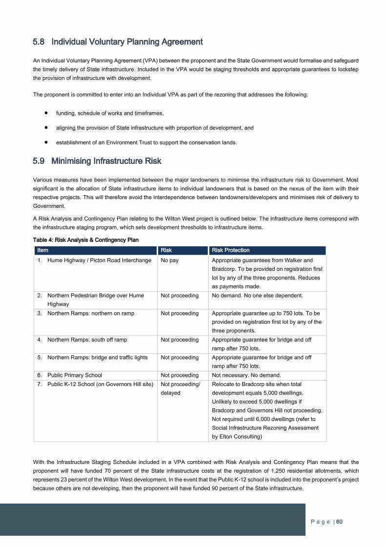
P a g e | 60
5.8 Individual Voluntary Planning Agreement
An Individual Voluntary Planning Agreement (VPA) between the proponent and the State Government would formalise and safeguard
the timely delivery of State infrastructure. Included in the VPA would be staging thresholds and appropriate guarantees to lockstep
the provision of infrastructure with development.
The proponent is committed to enter into an Individual VPA as part of the rezoning that addresses the following:
funding, schedule of works and timeframes,
aligning the provision of State infrastructure with proportion of development, and
establishment of an Environment Trust to support the conservation lands.
5.9 Minimising Infrastructure Risk
Various measures have been implemented between the major landowners to minimise the infrastructure risk to Government. Most
significant is the allocation of State infrastructure items to individual landowners that is based on the nexus of the item with their
respective projects. This will therefore avoid the interdependence between landowners/developers and minimises risk of delivery to
Government.
A Risk Analysis and Contingency Plan relating to the Wilton West project is outlined below. The infrastructure items correspond with
the infrastructure staging program, which sets development thresholds to infrastructure items.
Table 4: Risk Analysis & Contingency Plan
Item Risk Risk Protection
1. Hume Highway / Picton Road Interchange No pay Appropriate guarantees from Walker and
Bradcorp. To be provided on registration first
lot by any of the three proponents. Reduces
as payments made.
2. Northern Pedestrian Bridge over Hume
Highway
Not proceeding No demand. No one else dependent.
3. Northern Ramps: northern on ramp Not proceeding Appropriate guarantee up to 750 lots. To be
provided on registration first lot by any of the
three proponents.
4. Northern Ramps: south off ramp Not proceeding Appropriate guarantee for bridge and off
ramp after 750 lots.
5. Northern Ramps: bridge and traffic lights Not proceeding Appropriate guarantee for bridge and off
ramp after 750 lots.
6. Public Primary School Not proceeding Not necessary. No demand.
7. Public K-12 School (on Governors Hill site) Not proceeding/
delayed
Relocate to Bradcorp site when total
development equals 5,000 dwellings.
Unlikely to exceed 5,000 dwellings if
Bradcorp and Governors Hill not proceeding.
Not required until 6,000 dwellings (refer to
Social Infrastructure Rezoning Assessment
by Elton Consulting)
With the Infrastructure Staging Schedule included in a VPA combined with Risk Analysis and Contingency Plan means that the
proponent will have funded 70 percent of the State infrastructure costs at the registration of 1,250 residential allotments, which
represents 23 percent of the Wilton West development. In the event that the Public K-12 school is included into the proponent’s project
because others are not developing, then the proponent will have funded 90 percent of the State infrastructure.
P a g e | 61
At every stage of the development the funding of State infrastructure is significantly forward of the demand generated by the new
urban growth and this is secured in a legally binding agreement. Therefore, it can be assured that infrastructure delivery and ‘at no
additional cost to Government’ imperatives are met with no risk to Government. This can only be guaranteed with the rezoning of the
whole Bradcorp landholding to enable residential development across the whole site as per the Master Plan (refer Figure 16).
5.10 Resolution of Co-existence with Mining
There are areas below the surface that have been identified for longwall coal mining, which is programed to commence in 25 to 30
years. The Minster for Planning has written to Bradcorp advising that the Department of Planning & Environment is working with other
government agencies to establish an approach to the coexistence of mining and urban development (refer Appendix 2).
The Greater Macarthur Land Release Investigation included investigation into sub-surface mining activities. The Resource / Mining
Framework Report by AgEconPlus Consulting prepared for the Department of Planning & Environment, indicated that;
”In the longer term, 15-30 years, the certainty that mining will occur in a particular geometry or that a particular mine
will continue to be operational tends to reduce because exploration activities are yet to be fully completed and the
mine plans tend to be largely conceptual. Even though approval to mine has been granted, such approval does not
guarantee an operation will remain viable. When this lack of certainty is coupled with the costs of delaying surface
development, the argument for forestalling surface development to accommodate future mining becomes less
convincing.”
The mining report is clear that mining beyond 25 years should not preclude urban development in affected areas, such as Wilton
West. However, there is a need to plan for mining to exist with urban development on the surface.
South 32 currently holds the mining rights to extract coal directly below a portion of the Wilton West landholding. The method of
extraction is by a sub-surface longwall operation. Whilst the area within Wilton West that is subject to South 32’s mining plans has
substantially reduced recently, a smaller portion of the subject site remains subject to sub-surface longwall mining. The main impact
on urban development is that it needs to be designed to withstand any subsidence impacts that may result for the sub-surface mining.
It has been demonstrated that sub-surface longwall mining and urban development on the surface can co-exist. Co-existence of sub-
surface mining and urban development requires that development on the surface adopts a higher standard of design specification to
withstand the extent of subsidence that could occur as a consequence of the mining below. To determine the design specifications,
site specific investigations need to be undertaken to ensure the urban development can be constructed to the necessary standards
to alleviate impacts from subsidence. This more detailed analysis is being progressed at present to ensure mining does not inhibit
urban development.
In accordance with the Greater Macarthur Land Release Investigation, steps to progress the rezoning and coexistence with mining
are outlined below.
Rezoning Pathway Steps
The following sections relate to the process promoted in relation to coal mining outlined on page 8 of the GMLRI Delivery Pathway
Section of the Preliminary Strategy & Action Plan.
1. Planning for early Exploration and Resource Extraction
No easements or covenants are required. The only consent that is required is from the landowner, which in the case of Bradcorp,
consent has already been granted and exploration commenced by BHP Billiton. A staging proposal for completion of exploration is
included in reports previously provided to Government.
Surface gas drainage infrastructure can be located remotely from the urban development area within lands owned by South 32 along
the western boundary of Bradcorp’s land, which is identified in the GMLRI documentation as being for employment land uses. The
location of surface vent infrastructure in this location will serve any mining operations irrespective of any proposed future mine plan.
Accordingly, the need for endorsement for covenants and/or easements is superfluous.
2. Building Design Standards
Section 2 of the Pathway Steps on page 8 of the Preliminary Strategy & Action Plan relates to building design standards and
compliance regimes and establishes how the subsidence impacts on the proposed development at Wilton Junction can be minimised.
P a g e | 62
The MSB has existing design guidelines for residential development titled “Graduated Guidelines for Residential Construction (New
South Wales)” and apply throughout proclaimed mine subsidence areas - these guidelines will also apply at Wilton.
In relation to non-residential land uses, guidelines need to be implemented to require that buildings be designed and construction
supervised to provide for mine subsidence parameters of tilt, strain and curvature by relevant professional experts.
The MSB can determine the design requirements and provide subsidence parameters to the developers to ensure that the designs
are able to accommodate subsidence movements with minimal impact. The designs of all buildings, structures and services within a
Mine Subsidence District require the approval of the Mine Subsidence Board before construction can commence.
In relation to design parameters for non-residential buildings the MSB and Department of Mineral Resources has already adopted
these parameters for the long walls for Wilton Junction.
The problems of managing the impacts are significantly reduced when the building structures and associated items of infrastructure
are designed to accommodate subsidence movements. In addition to design measures, construction of the development need to be
carefully controlled to ensure that the building structures and associated items of infrastructure are built in accordance with the
designs.
To meet these challenges, surface development will comply with the requirements of Section 2 of the Pathway Steps relates to building
design standards and compliance regimes.
3. Long Term Urban Land Release Sequencing Plan
The preparation of a Long Term Sequencing Plan for both the urban land release and approved resource extraction operations is
irrelevant, in the circumstances where urban development precedes mining. Other landowners affected by mining will need to address
the pathway step requirements independently, especially as they relate to the communication strategy applying to those owners.
4. Communications Strategy
A Communications Strategy for Mine Subsidence has been created by the Wilton Junction proponents and has been previously
submitted to the Government. The Strategy meets the conditions of the Rezoning Pathway Steps for the Wilton Priority Growth Area
by setting out actions to inform all potential purchasers of residential, commercial and retail buildings of future mining in the area and
what this means for them.
P a g e | 63
Part 2 – PLANNING PROPOSAL
1 OBJECTIVES OR INTENDED OUTCOMES
1.1 Explanation of Objectives and Intended Outcomes
The primary objective of this planning proposal is:
To amend the Wollondilly Local Environmental Plan 2011 to enable urban development of rural land to create a
new self-contained community comprising business activities, neighbourhood centres, private and public schools,
a range of residential housing (detached housing, the ‘missing middle’ and apartments), sporting facilities and local
parks, major infrastructure, and the conservation of a substantial area of existing natural bushland.
The Wilton West site comprises the entire north western portion of the Wilton Priority Growth Area and rezoning the site will make a
significant contribution to the delivery of Wilton New Town. The proposal is therefore fundamental in achieving the NSW Government’s
objectives for urban growth in South West Sydney.
The Wilton West Precinct Indicative Layout Plan prepared for the site translates the objectives and intended outcomes of the proposal
by identifying land uses and the road network (refer to Figure 24) to inform the rezoning. The Precinct Indicative Layout Plan promotes
a sustainable and liveable community with a range of land uses incorporating business, residential, education, employment, mixed
uses and open space.
The Precinct Indicative Layout Plan provides for residential land uses to support around 5,400 new homes. Given the scale of the site
it has capacity to accommodate approximately a third of the new population forecast for Wilton New Town by the Department of
Planning & Environment. The proposal incorporates low density residential and medium density residential land uses to promote
housing diversity. Medium density land uses are located in areas of higher amenity in close proximity to transport corridors, mixed
use and commercial zones, community facilities and the Lakeside Activity Hub.
The objectives and intended outcomes of this rezoning proposal uphold the strategic plans and projections for the Wilton Priority
Growth Area and will result in the extensive advancement of urban development and housing supply within the region, as anticipated
by A Plan for Growing Sydney.
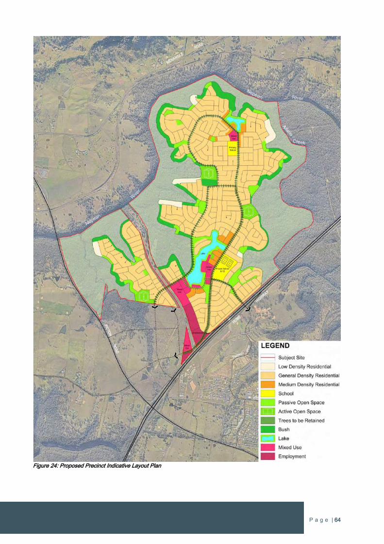
P a g e | 64
Figure 24: Proposed Precinct Indicative Layout Plan
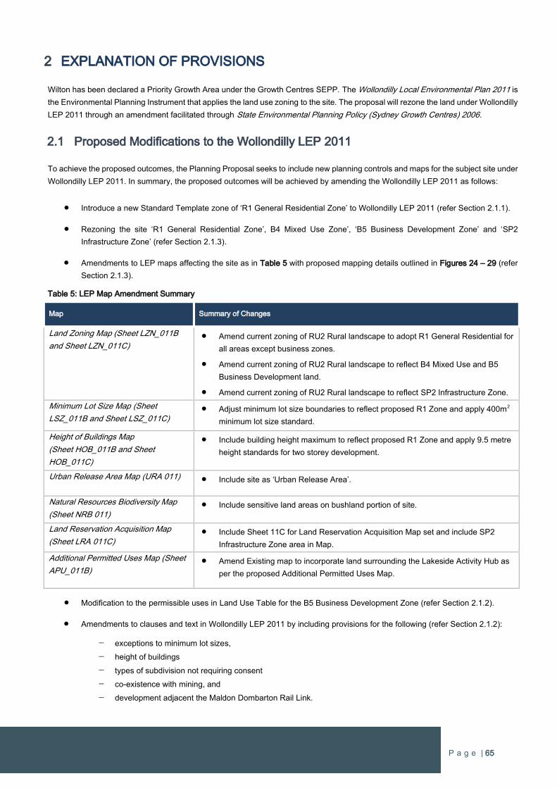
P a g e | 65
2 EXPLANATION OF PROVISIONS
Wilton has been declared a Priority Growth Area under the Growth Centres SEPP. The Wollondilly Local Environmental Plan 2011 is
the Environmental Planning Instrument that applies the land use zoning to the site. The proposal will rezone the land under Wollondilly
LEP 2011 through an amendment facilitated through State Environmental Planning Policy (Sydney Growth Centres) 2006.
2.1 Proposed Modifications to the Wollondilly LEP 2011
To achieve the proposed outcomes, the Planning Proposal seeks to include new planning controls and maps for the subject site under
Wollondilly LEP 2011. In summary, the proposed outcomes will be achieved by amending the Wollondilly LEP 2011 as follows:
Introduce a new Standard Template zone of ‘R1 General Residential Zone’ to Wollondilly LEP 2011 (refer Section 2.1.1).
Rezoning the site ‘R1 General Residential Zone’, B4 Mixed Use Zone’, ‘B5 Business Development Zone’ and ‘SP2
Infrastructure Zone’ (refer Section 2.1.3).
Amendments to LEP maps affecting the site as in Table 5 with proposed mapping details outlined in Figures 24 – 29 (refer
Section 2.1.3).
Table 5: LEP Map Amendment Summary
Map Summary of Changes
Land Zoning Map (Sheet LZN_011B
and Sheet LZN_011C) Amend current zoning of RU2 Rural landscape to adopt R1 General Residential for
all areas except business zones.
Amend current zoning of RU2 Rural landscape to reflect B4 Mixed Use and B5
Business Development land.
Amend current zoning of RU2 Rural landscape to reflect SP2 Infrastructure Zone.
Minimum Lot Size Map (Sheet
LSZ_011B and Sheet LSZ_011C) Adjust minimum lot size boundaries to reflect proposed R1 Zone and apply 400m2
minimum lot size standard.
Height of Buildings Map
(Sheet HOB_011B and Sheet
HOB_011C)
Include building height maximum to reflect proposed R1 Zone and apply 9.5 metre
height standards for two storey development.
Urban Release Area Map (URA 011) Include site as ‘Urban Release Area’.
Natural Resources Biodiversity Map
(Sheet NRB 011) Include sensitive land areas on bushland portion of site.
Land Reservation Acquisition Map
(Sheet LRA 011C) Include Sheet 11C for Land Reservation Acquisition Map set and include SP2
Infrastructure Zone area in Map.
Additional Permitted Uses Map (Sheet
APU_011B) Amend Existing map to incorporate land surrounding the Lakeside Activity Hub as
per the proposed Additional Permitted Uses Map.
Modification to the permissible uses in Land Use Table for the B5 Business Development Zone (refer Section 2.1.2).
Amendments to clauses and text in Wollondilly LEP 2011 by including provisions for the following (refer Section 2.1.2):
exceptions to minimum lot sizes,
height of buildings
types of subdivision not requiring consent
co-existence with mining, and
development adjacent the Maldon Dombarton Rail Link.
P a g e | 66
2.1.1 Introduce R1 General Residential Zone into LEP
Wollondilly LEP 2011 currently does not include the R1 General Residential zone, which is a ‘residential’ zone defined in The Standard
Instrument. The Department of Planning & Environment’s LEP practice note PN-002 describes The R1 General Residential Zone as
follows:
This zone is to provide for a broad variety of residential densities and housing types, including ‘dwelling houses,’
‘multi-dwelling housing,’ ‘residential flat buildings,’ ‘boarding houses’ and ‘seniors housing’. The zone also includes
additional uses that provide facilities or services to residents, including ‘neighbourhood shops,’ ‘community facilities,’
‘child care centres’ and ‘respite day care centres.
The R1 zone is the most appropriate zone to provide a diverse range of housing options within Wilton Growth Area. This will provide
greater flexibility at the detailed design stage with the delivery of a diverse range of housing, open spaces and other complementary
residential uses. The zone will also allow for the provision of other land uses within residential areas which help to promote growth
and sustainable neighbourhoods by servicing the local community.
2.1.2 Amendments to LEP Text
2.1.2.1 LAND USE TABLE
R1 General Residential Zone
The R1 General Residential Zone requires objectives and permissible/prohibited uses to be included to the LEP to complete the
introduction of the new zone.
It is proposed that a complete section for the R1 Zone be inserted to the Land use table as follows:
R1 GENERAL RESIDENTIAL
1 Objectives of zone
To provide for the housing needs of the community.
To provide for a variety of housing types and densities.
To enable other land uses that provide facilities or services to meet the day to day needs of residents.
2 Permitted without consent
Home occupations
3 Permitted with consent
Attached dwellings; Advertising structure; Boarding houses; Boat launching ramps; Boat sheds; Child care
centres; Community facilities; Dwelling houses; Emergency services facilities; Environmental facilities;
Environmental protection works; Exhibition homes; Exhibition villages; Group homes; Home business; Home
business (sex services); Home industry; Home-based child care; Hostels; Information and education facilities;
Jetties; Markets; Multi dwelling housing; Neighbourhood shops; Places of public worship; Recreation areas;
Recreation facilities (outdoor); Residential accommodation; Residential flat buildings; Respite day care
centres; Roads; Semi-detached dwellings; Seniors housing; Sewerage systems; Shop top housing; Signage;
Tourist and visitor accommodation; Water recreation structures; Water supply systems; Wharf or boating
facilities; Any other development not specified in item 2 or 4
P a g e | 67
4 Prohibited
Agriculture; Air transport facilities; Commercial premises; Cemeteries; Depots; Entertainment Facilities;
Freight transport facilities; Function centres (other than those within recreation areas or operated in
conjunction with recreation areas or recreation facilities); Heavy industrial storage establishments; Industries;
Mortuaries; Passenger transport facilities; Public administration buildings; Registered clubs; Restricted
premises; Restriction facilities; Service stations; Sex services premises; Storage premises; Transport depots;
Truck depots; Vehicle body repair workshops; Vehicle repair stations; Warehouse or distribution centres;
Waste or resource management facilities; Wholesale supplies.
B5 Business Development Zone
Additional land use definitions being proposed for the B5 Business Development Zone. The Department’s LEP practice note PN-002
describes The B5 Business Zone as follows:
This zone is to provide for business, warehouse and bulky goods retail uses that require a large floor area, in locations
that are close to, and that support the viability of, centres. This zone provides for employment generating uses such
as ‘warehouses or distribution centres,’ ‘bulky goods premises,’ ‘hardware and building supplies,’ ‘landscaping
material supplies’ and ‘garden centres.’
The inclusion of new uses as being permissible with consent under the B5 Zone will enable a broader range of employment
generating activities and provide for a broader range of local services. The inclusion of an objective that promotes the Town
Centre
It is proposed that the R5 Zone section of the Land use table be replaced with the following text:
B5 BUSINESS DEVELOPMENT
Zone B5 Business Development
1 Objectives of zone
To enable a mix of business and warehouse uses, and bulky goods premises that require a large floor area, in
locations that are close to, and that support the viability of, centres.
To maintain the economic strength of centres by limiting retail activity.
To provide a mixture of compatible land uses.
To enable other land uses that provide facilities or services to meet the day to day needs of workers in the area.
2 Permitted without consent
Nil
3 Permitted with consent
Amusement centres; Boat building and repair facilities; Business premises; Car parks; Community facilities; Depots;
Electricity generating works; Entertainment facilities; Environmental facilities; Environmental protection works; Food and
drink premises; Freight transport facilities; Function centres; Garden centres; High technology industry; Highway service
centres; Hotel or motel accommodation; Information and education facilities; Office premises; Places of public worship; Plant
nurseries; Recreation areas; Recreation facilities (indoor); Recreation facilities (outdoor); Registered clubs; Service stations;
Sewerage systems; Signage; Storage premises; Timber yards; Vehicle body repair workshops; Vehicle repair stations;
Vehicle sales or hire premises; Veterinary hospitals; Water recycling facilities; Water supply systems; Any other development
not specified in item 2 or 4.
P a g e | 68
4 Prohibited
Agriculture; Airstrips; Air transport facilities; Animal boarding and training establishments; Boat building and repair facilities;
Boat launching ramps; Boat sheds; Camping grounds; Caravan parks; Car parks; Cellar door premises; Cemeteries; Charter
and tourism boating facilities; Correctional centres; Crematoriums; Eco-tourist facilities; Electricity generating works;
Environmental facilities; Environmental protection works; Exhibition homes; Exhibition villages; Extractive industries; Farm
buildings; Flood mitigation works; Forestry; Freight transport facilities; Heavy industrial storage establishments; Helipads;
Home-based child care; Home businesses; Home occupations; Home occupation (sex services); Industries; Information and
education facilities; Jetties; Marinas; Moorings; Mooring pens; Mortuaries; Open cut mining; Plant nurseries; Recreation
areas; Recreation facilities (major); Recreation facilities (outdoor); Registered clubs; Research stations; Residential
accommodation; Restricted premises; Roadside stalls; Rural industries; Sewerage systems; Sex service premises; Shops;
Storage premises; Tourist and visitor accommodation; Transport depots; Truck depots; Vehicle body repair workshops;
Waste or resource management facilities; Water recreation structures; Water supply systems; Wharf or boating facilities
2.1.2.2 RETAIL
To achieve and maintain the retail hierarchy established within Council, it is proposed to include the following objective into the B4
Zone section of the Land use table:
To ensure that the scale of retail development does not impact on the hierarchy of retail centres within the Zone B2
Local Centre.
2.1.2.3 EXCEPTIONS TO MINIMUM LOT SIZES
It is proposed to provide exclusions to the minimum lot sizes depicted on the Minimum Lot Size Map for some types of residential
development. Residential development that is located in areas that achieve higher levels of amenity, such as opposite open space or
close to local services, may reduce the minimum lot size in the R1 General Residential Zone. The proposed provisions establish the
alternative minimum lot sizes for the respective types of residential development and the locational criteria which is determined by
distance.
4.1C Exceptions to minimum lot sizes for certain residential development within Zone R1 General Residential
(1) The objective of this clause is to encourage greater housing diversity in Zone R1 General Residential by
allowing denser forms of housing, in particular small lot housing, in areas of high residential amenity.
(2) Subject to sub clause (4), development consent may be granted for development on a lot within the Zone R1
General Residential for any of the following purposes if the area of the lot is equal to or greater than the area
specified below in relation to those purposes:
(a) Dual occupancy – 600 square metres
(b) Attached dwelling – 125 square metres
(c) Semi-detached dwelling – 125 square metres
(d) Multi dwelling housing – 600 square metres
(e) Residential flat building – 1000 square metres.
(3) Despite clause 4.1 and subject to sub clause (4), development consent may be granted for the subdivision of a lot on
which residential development is proposed to be carried out if the area of each resulting lot is at least the minimum
area for that purpose specified below:
(a) Dwelling house – 250 square metres
(b) Dual occupancy – 300 square metres
(c) Semi-detached dwelling – 125 square metres
(d) Attached dwelling – 125 square metres.
P a g e | 69
(4) The primary frontage of any development to which this clause applies must comply with at least one of the following:
(a) Within 200 metres of Zone B2 Local Centre
(b) Within 200 metres of Zone B4 Mixed Use
(c) Within 200 metres of a neighbourhood shop
(d) Within 200 metres of a recreation area.
It is proposed to include minimum lot sizes standards for residential uses for the B4 Mixed Use Zone in clauses and not annotate the
Minimum Lot Size Map. The minimum lot sizes for residential development allow small lot residential development as encouraged
within the mixed use zone.
4.1AB Minimum lot sizes for dwelling houses, dual occupancies, attached dwellings, multi dwelling housing and residential
flat buildings in Zone B4 Mixed Use.
(1) The objective of this clause is to ensure that the minimum size of lots for dwelling houses, dual occupancies, multi
dwelling housing and residential flat buildings in Zone B4 Mixed Use are sufficient for the provision of usable areas for
buildings and open space.
(2) Development must not be carried out on a lot within Zone B4 Mixed Use for any of the following purposes if the area
of the lot is less than the area specified below in relation to those purposes:
(a) Dwelling house – 250 square metres
(b) Dual occupancy – 600 square metres
(c) Attached dwelling – 125 square metres
(d) Semi-detached dwelling – 125 square metres
(e) Multi dwelling housing – 600 square metres
(f) Residential flat building – 1000 square metres.
2.1.2.4 HEIGHT OF BUILDINGS
The Wollondilly LEP currently does not apply a maximum building height for the subject site. It is proposed to include a maximum
building heights for the residential areas, which typically allows two-storey development, and a different building height for the
business/mixed use/commercial areas that enables more elevated buildings and structures that is more typical for this type of
development. Both of these height standards will be represented on the Height of Buildings Map. It is also proposed to insert an
additional clause specific to residential flat buildings that allows building height to exceed the mapped height limits. The provisions
include location criteria and amenity considerations to ensure that any residential flat buildings that are over the mapped height limits
will not have an adverse impact on others.
The proposed additional subclauses (3) and (4) is recommended to be included under Clause 4.3 Height of Buildings:
Clause 4.3 Height of Buildings
(3) The consent authority may grant development consent for development for the purpose of residential flat
buildings on land within Zone R1 General Residential that exceeds 9.5m in height above finished ground
level, if the consent authority is satisfied that the development:
(a) Is located within 200 metres of:
(i) Zone B2 Local Centre
(ii) Zone B4 Mixed Use
(iii) Neighbourhood Shop;
(iv) Recreation Area.
P a g e | 70
(b) is not likely to have an adverse impact on the existing or future amenity of any adjoining land on which
residential development is permitted, having regard to over shadowing, visual impact and any impact on
privacy.
(4) The consent authority may grant development consent for development for the purpose of residential flat
buildings on land within Zone B4 Mixed Use that exceeds 12m in height above finished ground level, if the
consent authority is satisfied that the development is not likely to have an adverse impact on the existing or
future amenity of any adjoining land on which residential development is permitted, having regard to over
shadowing, visual impact and any impact on privacy.
2.1.2.5 SUBDIVISION CONSENT APPROVAL
It is proposed to allow some types of subdivision to be permitted without requiring consent. As it is expected there will be a significant
number of Development Applications during the early stages of the Wilton New Town, it is proposed to include provisions that allow
some types of subdivision which will not impose any significant environmental impact. This will also allow Council to better manage it
resources for undertaking assessments for the Wilton New Town area. The proposed clause is to be included under Clause 2.6
Subdivision:
Clause 2.6 Subdivision – consent requirements
(3) However, consent is not required for a subdivision for the purposes only of any one or more of the following:
(a) Widening a public road.
(b) A minor realignment of boundaries:
(i) That will not create additional lots or the opportunity for additional dwellings
(ii) That will not result in one or more lots that are smaller than the minimum size shown on
the Lot Size Map in relation to the land concerned (unless the original lot or lots are
already smaller than the minimum size)
(iii) That will not adversely affect the provision of existing services on a lot
(iv) That will not result in any increased bush fire risk to existing buildings.
(c) A consolidation of lots that does not create additional lots or the opportunity for additional dwellings.
(d) Rectifying an encroachment on a lot.
(e) Creating a public reserve.
(f) Excising from a lot land that is, or in intended to be, used for public purposes, including drainage
purposes, rural fire brigade or other emergency service purposes or public conveniences.
2.1.2.6 SATISFACTORY ARRANGEMENTS FOR STATE INFRASTRUCTURE
Clause 6.1 requires satisfactory arrangements being made for the provision of State infrastructure and certification by the Secretary
of the Department of Planning & Environment before subdivision can proceed in an urban release area. The area identified as ‘Wilton
West’ will need to be referenced in the clause and included on the Urban Release Areas Map. The proposed amended text for
subclause (2) in Clause 6.1 Arrangements for designated State public infrastructure:
6.1 Arrangements for designated State public infrastructure
(2) Development consent must not be granted for the subdivision of land in an urban release area if the subdivision would
create a lot smaller than the minimum lot size permitted on the land immediately before:
(a) in relation to land shown as “Silverdale” on the Urban Release Area Map—16 September 2005, or
(b) in relation to land shown as “Wilton” on the Urban Release Area Map—23 February 2007, or
(c) in relation to land shown as “Wilton West” on the Urban Release Area Map—<<insert date>>, or
P a g e | 71
(d) in relation to any other land—the land became, or became part of, an urban release area,
unless the Director-General has certified in writing to the consent authority that satisfactory arrangements have been
made to contribute to the provision of designated State public infrastructure in relation to that lot.
2.1.2.7 DEVELOPMENT SURROUNDING MALDON DOMBARTON RAIL LINK
The Maldon Dombarton Rail Link (MDRL) reserve traverses the site and physical works have partially commenced but have been
deferred some many years. Whilst The MDRL is currently on hold it is proposed to include additional provisions within the LEP to
ensure surrounding development and sensitive users with the site are not impacted by the rail operations if they eventuate in the
future. The following text is proposed under Part 7 Additional Provisions:
Clause 7.7 Development or land within or adjacent to MDRL
(1) This clause applies to development that is on land in or adjacent to MDRL and that the consent authority
considers is likely to be adversely affected by rail noise or vibration.
(2) Before granting development consent for development on land to which this clause applies, the consent
authority must consider the following matters:
(a) If the development is for the purposes of residential accommodation – the impact of noise and
vibration associated with the operation of the railway line would have on the development,
(b) Any proposed measures incorporated into the development that limit the impact of such noise and
vibrations associated with the railway line.
(3) All buildings containing residential accommodation or sensitive uses shall have a minimum setback of 60
metres from a rail line, and shall be designed and constructed to mitigate rail noise and vibration impacts
associated with the operation of the railway line.
(4) Before granting development consent for the development of buildings containing residential
accommodation or sensitive uses, Council, in liaison with Transport for NSW, can reduce the minimum
setback as outlined in subclause (3), provided that rail noise and vibration mitigation measures have
demonstrated the impact is minimised.
2.1.2.8 ADDITIONAL PERMITTED USES
Lakeside Activity Hub
The proposed masterplan includes a Lakeside Activity Hub which adjoins land zoned B4 Mixed Use. Under the provisions of the LEP
certain watercraft and water facilities are prohibited. It is proposed that these uses be included as an additional permitted use specific
to this area to allow for the greater enjoyment and utilisation of this area by the community. An additional map has also been proposed
to support this clause.
The following text is recommended to be included under Schedule 1 of the LEP:
Schedule 1 Additional permitted used
9 Use of certain land at Wilton West in Zone B4 Mixed Use
(1) This clause applies to land identified within the Zone B4 Mixed Use and is located adjacent to the lake, being
Pt. Lot 2 DP 702024.
(2) Development for the purposes of boat sheds
2.1.3 Proposed Mapping for LEP
The proposed mapping for the Wollondilly LEP 2011 is outlined in Figures 25 – 31.

P a g e | 72
Land Use Zoning Map
The entire site is currently zoned RU2 Landscape under the Wollondilly LEP 2011. The proposed changes to the land use zoning
map is rezone all non-employment areas R1 General Residential Zone. The local activity centres are to be rezoned B4 Mixed Use to
facilitate the establishment of the employment generating uses and local services for the future community. An area of B5 Business
Development is proposed adjacent to the Maldon Dombarton Railway Link to provide for larger format commercial activities. The land
use zoning is consistent with the Master Plan included in this proposal.
Figure 25: Proposed Land Use Zoning Map
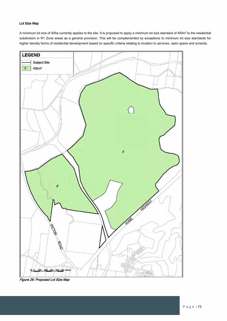
P a g e | 73
Lot Size Map
A minimum lot size of 40ha currently applies to the site. It is proposed to apply a minimum lot size standard of 400m2 to the residential
subdivision in R1 Zone areas as a general provision. This will be complemented by exceptions to minimum lot size standards for
higher density forms of residential development based on specific criteria relating to location to services, open space and amenity.
Figure 26: Proposed Lot Size Map
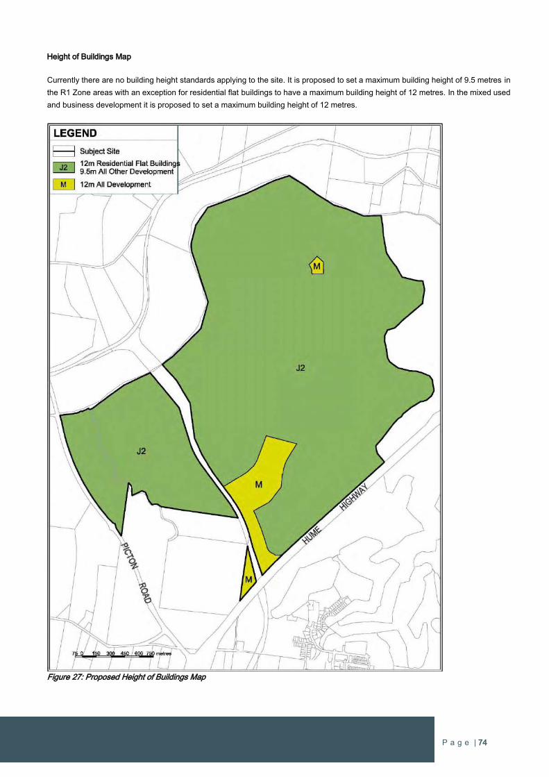
P a g e | 74
Height of Buildings Map
Currently there are no building height standards applying to the site. It is proposed to set a maximum building height of 9.5 metres in
the R1 Zone areas with an exception for residential flat buildings to have a maximum building height of 12 metres. In the mixed used
and business development it is proposed to set a maximum building height of 12 metres.
Figure 27: Proposed Height of Buildings Map

P a g e | 75
Urban Release Area Map
The Urban Release Area Map is to be amended to include the site as a release area in the LEP.
.
Figure 28: Proposed Urban Release Area Map
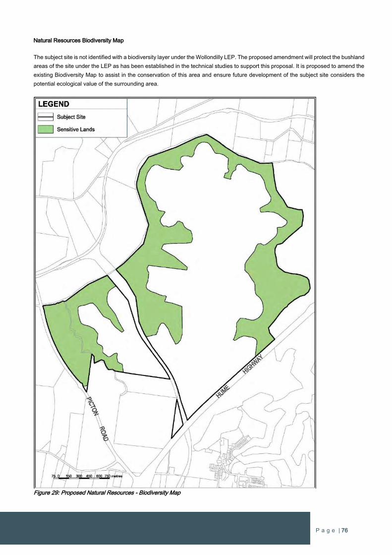
P a g e | 76
Natural Resources Biodiversity Map
The subject site is not identified with a biodiversity layer under the Wollondilly LEP. The proposed amendment will protect the bushland
areas of the site under the LEP as has been established in the technical studies to support this proposal. It is proposed to amend the
existing Biodiversity Map to assist in the conservation of this area and ensure future development of the subject site considers the
potential ecological value of the surrounding area.
Figure 29: Proposed Natural Resources - Biodiversity Map
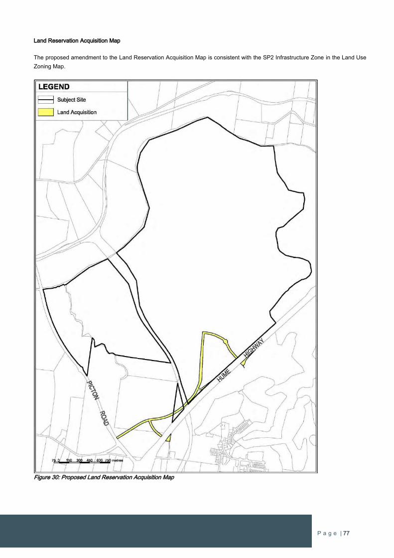
P a g e | 77
Land Reservation Acquisition Map
The proposed amendment to the Land Reservation Acquisition Map is consistent with the SP2 Infrastructure Zone in the Land Use
Zoning Map.
Figure 30: Proposed Land Reservation Acquisition Map

P a g e | 78
Additional Permitted Land Uses Map
As outlined in section 2.1.2.7 Additional Permitted Uses, the existing map is proposed to be amended to support additional watercraft
and water facilities on the lake and surrounds.
Figure 31: Proposed Additional Permitted Land Zoning Map
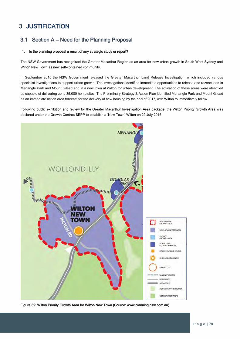
P a g e | 79
3 JUSTIFICATION
3.1 Section A – Need for the Planning Proposal
1. Is the planning proposal a result of any strategic study or report?
The NSW Government has recognised the Greater Macarthur Region as an area for new urban growth in South West Sydney and
Wilton New Town as new self-contained community.
In September 2015 the NSW Government released the Greater Macarthur Land Release Investigation, which included various
specialist investigations to support urban growth. The investigations identified immediate opportunities to release and rezone land in
Menangle Park and Mount Gilead and in a new town at Wilton for urban development. The activation of these areas were identified
as capable of delivering up to 35,000 home sites. The Preliminary Strategy & Action Plan identified Menangle Park and Mount Gilead
as an immediate action area forecast for the delivery of new housing by the end of 2017, with Wilton to immediately follow.
Following public exhibition and review for the Greater Macarthur Investigation Area package, the Wilton Priority Growth Area was
declared under the Growth Centres SEPP to establish a ‘New Town’ Wilton on 29 July 2016.
Figure 32: Wilton Priority Growth Area for Wilton New Town (Source: www.planning.nsw.com.au)
P a g e | 80
The release identifies Wilton New Town as ready to deliver homes by early 2018, with residents and local services to be provided
“within each neighbourhood and roads upgraded in tandem with development.”
The Government has released a community update Greater Macarthur & Wilton 2016 and Beyond which forecasts the delivery of
homes within Wilton by early 2018, with residents by late 2018. The NSW Government establishes the vision for Wilton as:
“We’ll enable places for families to thrive, the environment to be protected and business to
flourish. Communities will be great places to live and work. Infrastructure for new areas will be
supplied at no additional cost to government.”
(Greater Macarthur & Wilton: 2016 and Beyond, NSW Department of Planning & Environment)
The proponent of this Planning Proposal share the NSW Government’s vision for their landholding to create a place where people
want to live and work that adopts ‘Garden City’ principles and conservation of the environmental qualities of the site.
The NSW Government has undertaken substantial strategic planning and investigations to determine the suitability and capability for
urban development in the Wilton Priority Growth Area to create Wilton New Town. The proposed rezoning is as a response to the
strategic planning and studies undertaken by the NSW Government to ensure the proper and orderly planning for urban development.
This Planning Proposal is entirely consistent with the Government’s vision and the strategic planning undertaken for the locality.
2. Is the planning proposal the best means of achieving the objectives or intended outcomes, or is there a better way?
Rezoning the land for urban development to create Wilton New Town is the only way of achieving the outcomes in this Planning
Proposal.
This Planning Proposal seeks to rezone land within the Wilton Priority Growth Area for urban and residential development under State
Environmental Planning Policy (Sydney Region Growth Centres) 2006.
The NSW Minister for Planning published an amendment to the State Environmental Planning Policy (Sydney Growth Centres) 2006
on 29 July 2016. State Environmental Planning Policy (Sydney Region Growth Centres) Amendment (Wilton) 2016 includes Wilton
as a Priority Growth Area under the Growth Centres SEPP.
Notwithstanding the Wilton Priority Growth Area has been declared under the Growth Centres SEPP, the Wollondilly LEP 2011
remains the Environmental Planning Instrument that applies land use zoning to the land.
Whilst it is acknowledged that various potential rezoning pathways have been foreshadowed by the Department of Planning, this
Planning Proposal is a ‘proponent-led’ rezoning. With early consultation with the Department and Wollondilly Shire Council, it has
been established that the best means of achieving the rezoning is through an amendment under the Growth Centres SEPP that
amends the zoning and clauses of Wollondilly LEP 2011. The amending SEPP is to be enforce for 1 day to effect the amendments to
the Wollondilly LEP. Once the Wollondilly LEP is amended, the SEPP is repealed. This type of SEPP amendment is known as a ‘24
hour SEPP’.
The ’24 hour SEPP’ approach has support from the Department of Planning & Environment and Wollondilly Shire Council as the best
means of rezoning land and achieving the intended outcomes in this Planning Proposal. Other potential rezoning pathways that have
been considered, being rezoning land in the Growth Centres SEPP and an amendment through the LEP Gateway Process, have not
been determined to be better methods for progressing the rezoning or enabling urban development within Wilton New Town.
The rezoning of the site for urban development will also establish a clear understanding of intent to the community of Wollondilly and
the general public for delivering new urban growth in the locality.

P a g e | 81
3.2 Section B – Relationship to strategic planning framework
3. Is the planning proposal consistent with the objectives and actions of the applicable regional or sub-regional strategy (including
the Sydney Metropolitan Strategy and exhibited draft strategies)?
The Greater Macarthur Region has been subject to extensive strategic planning focus in recent years as it is now an established
growth region of Metropolitan Sydney. This is demonstrated through the release of ‘A Plan for Growing Sydney’ in 2014 and
subsequent declaration of the Wilton Priority Grown Area. In addition, the Greater Sydney Commission has released the Draft South
West District Plan for public review and comment.
Draft South West District Plan
The South West District is Sydney’s fastest growing District where urban and rural living meet and residents can enjoy the best of
both worlds if planned properly.
The Draft District Plan outlines a 20-year vision for the South West District of Greater Sydney, which is as follows:
South West District is a place where opportunity, success and prosperity are forged from humble beginnings, where
innovation thrives, smart jobs are created, international business connections are established and global
investment is supported. Local people form the basis of a highly skilled and educated workforce that continues to
grow and invest in itself and its future. (P1 Draft South West District Plan)
The Draft South West District Plan identifies South West Sydney as ‘a global innovation gateway and a destination of choice for
existing and new communities, local residential development and visitors’ which will ‘offer a greater range of distinct and authentic
precincts with culturally diverse food, inspiring stories and genuine experiences.’
The role of the Draft South West District Plan is to guide the preparation of planning proposals under Part 3 of the Act
District Priorities, which are under Productivity, Liveability or Sustainability groupings, establish clear directions for considering
planning proposals. It is necessary to address every priority where relevant in each case by detailing how they relate to a planning
proposal. Given the scale and attributes of the Planning Proposal for Wilton West, there is a relationship to every District Priority in
the South West District.
Table 6 outlines each District Priority and how this proposal meets the respective requirements.
Table 6: Response to Draft South West District Plan District Priorities
SOUTH WEST DISTRICT PLAN PRIORITY COMPLIANCE STATEMENT
Productivity Priority 1: Create high quality urban
amenity across the Western City
The economic prosperity of the District will be
influenced by the quality of the public realm, and
urban design of centres, commercial areas and
infrastructure. To create a strong sense of place, the
relevant planning authorities must establish an urban
design framework for the development of centres,
commercial areas and transport infrastructure.
The proposed rezoning will enable the delivery of a new community
that has a diverse range of amenity benefits. The proposal includes a
large man made waterbody that will form the centrepiece for activity,
employment, entertainment, recreation and education in addition to
residential amenity. The high amenity public realm will attract business
and encourage economic prosperity as it instils a strong identity and
sense of place in South West Sydney.
The planning for Wilton West is design-led with an urban design
structure included in this proposal that depicts activity centres,
employment lands and major transport connections and infrastructure.
P a g e | 82
Productivity Priority 2: Manage growth and change in
strategic and district centres, and, as relevant, local
centres
When undertaking planning for strategic, district and
local centres, the relevant planning authority should
consider:
opportunities for existing centres to grow and
new centres to be planned to meet forecast
demand across a range of retail types
the need to reinforce the suitability of centres
for retail and commercial uses while
encouraging a competitive market
the commercial requirements of retailers and
commercial operators such as servicing,
location, visibility and accessibility
the use of the B3 Commercial Core Zones in
strategic centres and where appropriate in
district centres to reinforce and support the
operation and viability of non-residential uses
including local office markets
When preparing strategic plans the relevant planning
authority needs to demonstrate how its planning for
centres has considered strategies to:
deliver on the strategic and district centres job
targets
meet the retail and service needs of the
community
facilitate the reinforcement and/or expansion of
allied health and research activities
promote the use of walking, cycling and
integrated public transport solutions
provide urban spaces such as meeting places
and playgrounds
respond to the centre’s heritage and history
promote community arts and cultural activities
reflect crime prevention through environmental
design (CPTED)
principles such as safety and management
manage the transition between higher intensity
activity in and around a centre and lower
intensity activity that frames the centre.
The NSW Government has identified the Wilton Priority Growth Area
to establish Wilton New Town. Central to the establishment of the new
town is a major centre that is identified outside the subject site, which
the NSW Department of Planning & Environment projects to support
around approximately 100,000-150,000m² of retail and employment
Gross Floor Area.
The new major centre for Wilton New Town is being further
investigated and planned by the NSW Government and Wollondilly
Shire Council. To complement the major centre will be numerous
neighbourhood level centres that will have important roles in
supporting local jobs and services for the community of the New Town.
Wilton West is identified to contain two local centres. The first will be
the lakeside activity hub that will be a node of employment, services
and amenity for the first residents. It will also be a significant
contributor for providing employment and education facilities in the
new urban area.
This proposal is consistent with the NSW Government’s plans to build
a major centre for Wilton New Town, particularly as the scale of Wilton
West provides a significant portion of the future population to support
the creation of the New Town. The proposal also provides two local
neighbourhood centres that will complement the major centre by
providing amenity and local jobs and services to the future local
community.
P a g e | 83
Productivity Priority 3: Prioritise the provision of retail
floor space in centres
When preparing retail and commercial strategies to
inform local planning, the following matters should be
considered:
existing and future supply and demand for retail
floor space within the District based on the
Department of Planning and Environment’s
medium population growth scenario
the accessibility of different types of retail and
commercial floor space to communities
opportunities to allow retail and commercial
activities to innovate
the impacts of new retail and commercial
proposals to the viability and vitality of existing
and planned centres
the need for new retail development to
reinforce/enhance the public domain
the net social, economic and environmental
benefits of new supply within different locations
Action P18: Plan for and facilitate the attraction of
new jobs in Wilton New Town
The Department of Planning and Environment will:
work with Wollondilly Council and other
stakeholders to develop economic
development strategies that can attract
businesses to Wilton New Town and support
job creation
ensure that satisfactory arrangements are in
place to deliver necessary infrastructure before
land is zoned for urban development.
The provision of retail services in Wilton West was considered as part
of the Wilton Junction planning process and is being considered as
part of the Department of Planning & Environment’s investigations for
Wilton New Town. Planning by the Department has identified an
indicative location for the Town Centre, which is currently to the south
of Wilton West.
Retail services will need to be provided at regional/district level with
the Town Centre but it is also necessary for local neighbourhood retail
services to be located outside the Town Centre to provide for the daily
retail needs of the future community. It is important that the first
residents of Wilton West have access to local retail services early in
the development, as the higher order core retail facilities of the Town
Centre will require a critical mass of new residents throughout Wilton
New Town. To not provide local services for new Wilton West
residents will inhibit the growth of the community and the
establishment of early employment.
MacroPlan Dimasi has prepared an Employment Strategy and
Economic Masterplan to clearly demonstrate how local retail services
are to be provided and how there is no impact on other existing or
proposed centres (refer Appendix 1). The Masterplan confirms the
following on Page viii in the Executive Summary of the report:
The Wilton Lakeside Precinct has clearly demonstrated the following:
- No economic impacts on other centres
- Clear integration with the public domain (i.e. the lake)
- The provision of a range of retail and commercial floorspace types
including tourism, health and education
- An innovative strategy to maximise local economic multipliers by
locating a proportion of the construction value chain in the local area
Whilst the MacroPlan Dimasi Employment Strategy and Economic
Masterplan was prepared before Action P18 was known, it delivers on
the actions specific to Wilton New Town.
Bradcorp has been progressive in the planning for Wilton West by
developing a site-specific employment strategy that considers various
employment sectors to ensure there are local jobs for the local people.
This is to be achieved through the strategies in the Economic
Masterplan to attract specific types of business, in particular
businesses that employ professionals, managers and executives.
Productivity Priority 4: Protect and support
employment and urban services land
Employment and urban service lands play a critical
role in the efficient and effective function of the
District. Owing to the comparative scarcity of this
resource, a holistic and precautionary approach to
their planning should be undertaken.
The proposal seeks to increase the land area for employment and
services lands in Wilton West and Wilton New Town. The future New
Town will require land for employment generating activities and there
are significant land areas identified for Mixed Use and Business
Development purposes within the site.
Once these areas have been zoned, encouraging activities to
generate economy and create jobs should be encouraged by all levels
of Government.
P a g e | 84
Accordingly, relevant planning authorities should
take a precautionary approach to rezoning
employment and urban services lands or adding
additional permissible uses that would hinder their
role and function.
The exception being where there is a clear direction
in the Regional Plan (currently A Plan for Growing
Sydney), the District Plan or an alternative strategy
endorsed by the relevant planning authority. Any
such alternative strategy should be based on a net
community benefit assessment (i.e. analysis of the
economic, environmental and social implications) of
the proposed exception taking into account a
Districtwide perspective in accordance with Action
P22 described below.
Action P22: Develop better understanding of the
value and operation of employment and urban
services land
In order to better understand the contribution of
employment and urban services land to the District’s
productivity, liveability and sustainability we will work
with Councils to further develop our research and
understanding of how the District’s employment and
urban services land operate, the range of uses they
support including their industry and supply chains,
their interdependencies, key constraints, and
opportunities to be improved. In doing this, the
particular characteristics and value add of these
locations will be identified to inform the preparation
of appropriate planning.
The Employment Strategy and Economic Masterplan by MacroPlan
Dimasi establishes economic and employment strategies over the
lifecycle of the Wilton West to phase new business and employment.
This Masterplan will set a framework for delivering the activities that
will utilise the employment and urban services land zoned by this
proposal. The investigative work undertaken to support this proposal
will also provide a better understanding and education to State and
local government on the establishment of new businesses and
employment in new growth areas, as required by Action P22.
Liveability Priority 1: Deliver South West District’s
five-year housing targets
It is a priority of the draft District Plans for Councils to
deliver these five-year housing targets. Councils
need to:
plan to provide sufficient capacity and monitor
delivery of the five-year housing targets
liaise with the Commission to identify barriers
to delivering additional housing in accordance
with the targets.
The South West District Plan sets Wollondilly Shire Council a five year
dwelling target of 1,550 dwellings. Once rezoned Wilton West will be
a significant resource to supply new housing in the Wollondilly LGA
and will be central to achieving the housing targets. Importantly, urban
growth at Wilton West will be fundamental to ensuring the
establishment of Wilton New Town is a success.
Liveability Priority 2: Deliver housing diversity
Relevant planning authorities should consider the
needs of the local population base in their local
housing strategy and how to align local planning
controls that:
The Wilton West Indicative Layout Plan identifies land for standard
and medium density development. There are also provisions for
residential flat buildings and mixed use development.
This proposal also includes provisions for smaller lot housing in areas
that can provide higher levels of amenity, such as land adjacent to
parks or neighbourhood centres.
P a g e | 85
address housing diversity that is relevant to the
needs of the existing and future local housing
market
deliver quality design outcomes for both
buildings and places.
The proposal planning framework will enable new housing that meets
the Planning Minister’s objectives to deliver the “missing middle” in
Sydney’s housing supply.
Liveability Priority 3: Implement the Affordable Rental
Housing Target
Building on Action 2.3.3 of A Plan for Growing
Sydney, when preparing planning proposals or
strategic plans for new urban renewal or greenfield
areas, the relevant planning authority will include an
Affordable Rental Housing Target as a form of
inclusionary zoning.
A target of 5% to 10% of new floorspace will be
applied at the rezoning stage so that it can be
factored into the development equation:
within areas that have been shown, via a local
housing strategy, or another form of
appropriate research, to have current or future
need for affordable rental housing
to applicable land within new urban renewal or
land release areas (government and private)
subject to development feasibility assessed at
a precinct scale
to all new floor space (above the existing
permissible floor space)
in addition to local and State development
contributions and cognisant of any public or
private subsidy for affordable rental housing
provision
to provide a range of dwelling types including
one, two and three+ bedroom homes
in accordance with any relevant guidance
developed by the Commission and Department
of Planning and Environment.
The Affordable Rental Housing dwellings will be
secured by the relevant planning authority and
passed onto a registered Community Housing
Provider to manage, further developing this
emerging sector of the economy.
In this regard, we encourage the NSW Government
to bring forward its own land to maximise affordable
housing and Affordable Rental Housing.
Currently there is no housing strategy or research for affordable rental
housing for the Wollondilly LGA and there is no established demand
for affordable rental housing in the Wilton Priority Growth Area.
Notwithstanding, Wilton West will be a new housing market to
compete with the existing Bingara Gorge and other larger developers
that could contribute to the supply of housing in Wilton New Town.
With the increase in local housing markets and supply, there will be a
positive effect on housing affordability and rent levels in the locality.
P a g e | 86
Liveability Priority 4: Increase social housing
provision
Relevant planning authorities and the Department of
Family and Community Services (and the Land and
Housing Corporation) should collaborate to optimise
housing and community diversity outcomes on sites
of social housing concentration.
Subject to appropriate consultation, feasibility
considerations and environmental assessment,
relevant planning authorities should translate optimal
outcomes for social housing sites into land use
controls.
The Department of Family and Community Services and the Land and
Housing Corporation should be consulted during the public exhibition
period to ascertain the need for social housing at Wilton New Town.
Wilton West will contain a variety of different housing types to support
a diverse and cohesive community. This will provide a strong
foundation to optimise housing and community diversity outcomes
with input from the Department of Family and Community Services
and the Land and Housing Corporation.
Liveability Priority 5: Facilitate the delivery of safe
and healthy places
Relevant planning authorities should:
facilitate the development of healthy and safe
built environments
consider the inclusion of planning mechanisms
such as floor space bonuses to incentivise the
provision of:
- neighbourhoods with good walking and
cycling connections particularly to schools
- social infrastructure such as public libraries
or child care
- urban agriculture, community and roof
gardens for productive food systems.
The centrepiece to Wilton West is a large lake that will provide
significant amenity benefits and encourage healthy activity for the
community. The design of the lake and surrounds ensures it will be
safe place with activity during the day and night and the activity hub
overlooking the public space.
The physical attributes of the site naturally create two neighbourhoods
for Wilton West. The Lakeside Activity Hub in the south will be the first
to be delivered which will be a place that locals can meet, eat and
drink, shop, work and recreate. Encouraging a diverse range of
activities through good design and building an attractive place will
ensure a safe and healthy place.
The northern neighbourhood will have a smaller local neighbourhood
centre to service its immediate local community. Whilst the Lakeside
Activity Hub to the south will also service the northern neighbourhood,
the northern neighbourhood centre will ensure the local community
(around 3,000 homes) will be close to services and provide some local
employment.
Liveability Priority 6: Facilitate enhanced walking and
cycling connections
Relevant planning authorities should facilitate
enhanced walking and cycling outcomes by giving
due consideration to the delivery of district and
regional connections and walkable neighbourhoods.
The centrepiece to Wilton West is a large lake that will encourage
healthy activity for the community. The lake will be encircled with paths
that will connect to the surrounding residential areas.
The bushland that surrounds the majority of Wilton West will include a
network of trails and natural paths that will support cycling,
bushwalking, jogging and running.
These two special places will be connected with pedestrian and
cycling connections to ensure everyone can easily and readily access
these facilities. A total of 22kms of pedestrian and cycling paths will
be provided in major transport corridors, and connections to local
parks and sporting facilities will enhance walking and cycling
connections.
P a g e | 87
Liveability Priority 7: Conserve heritage and unique
local characteristics
Relevant planning authorities should:
protect Aboriginal, cultural and natural heritage
and places, spaces and qualities valued by the
local community
require the adaptive re-use of historic and
heritage listed buildings and structures in a way
that enhances and respects heritage values
protect the heritage values of Camden Town
Centre and consider how its amenity and
character can be maintained.
A comprehensive assessment on Aboriginal and European heritage
has been undertaken for the site and is included in this proposal. Due
to the vast amount of native bushland being retained, in particular
around the cliffs of the Nepean River and natural drainage areas, the
Aboriginal heritage will be preserved. The study has identified areas
that may have Aboriginal heritage significance, which will require
further investigation as part of developing the site, and other items of
heritage significance that will need to be managed during the
development assessment phase. There are no items of European
heritage that need to be resolved as part of the rezoning process.
Liveability Priority 8: Foster the creative arts and
culture
Relevant planning authorities should:
integrate arts and cultural outcomes into urban
development through planning proposals that
nurture a culture of art in everyday local
spaces, provide flexible, accessible
performance spaces and enhance access to
the arts in all communities
give due consideration to the inclusion of
planning mechanisms that would incentivise
the establishment and resourcing of creative
hubs and incubators and accessible artist-run
spaces.
The Lakeside Activity Hub will be a highly attractive place where
people will want to work and meet which will strengthen the sense of
community and place at Wilton West.
It will include the spaces and facilities that will support and nurture the
spaces that promote creativity, culture and entertainment for the
community.
Liveability Priority 9: Share resources and spaces
Relevant planning authorities should consider the
delivery of shared local facilities such as community
hubs, cultural facilities and public libraries as
multifunctional shared spaces.
The Lakeside Activity Hub will be a focus for shared places and
resources. It will include the infrastructure and facilities that will
support shared spaces, workplaces and community activities.
Liveability Priority 10: Support innovative school
planning and delivery
Relevant planning authorities should give due
consideration to:
innovative land use and development
approaches including:
- using travel management plans, that
identify travel options, to reduce car use
- enabling the development and construction
of schools as flexible spaces, so they can
facilitate shared use and change over time
to meet varying community needs
the inclusion of planning mechanisms that
would incentivise the:
The provision of schools is imperative to Bradcorp and the Wilton West
project. Agreement has been made between Bradcorp and the
Anglican Schools Corporation to deliver a K-12 school adjacent to the
Lakeside Activity Hub. The Anglican Schools Corporation has been
involved in the design of the broader urban layout to ensure the
transport, land area and locational needs achieve the best possible
outcome for the school and the community.
A Public primary school is also identified within Wilton West to the
north. Bradcorp is also willing to provide for the Public K-12 school
should demand exist and it not being able to be delivered where
initially planned within Wilton New Town.
P a g e | 88
- development of new schools as part of
good quality and appropriate mixed use
developments
- the shared use of facilities between schools
and the local community including playing
fields and indoor facilities, so they can meet
wider community needs.
Liveability Priority 11: Provide socially and culturally
appropriate infrastructure and services
Relevant planning authorities should:
collaborate with Federal and State agencies
and service providers to integrate local and
District social infrastructure for Aboriginal
residents including preschools, child care and
aged care services
include appropriate planning mechanisms to
incentivise the provision of these services
required by local communities where
appropriate.
The Lakeside Precinct is envisaged as a premium location to attract a
range of social and cultural uses. This Precinct is separate and distinct
from the other planned retail/employment areas in Wilton New Town
as it will encourage uses and activities that embody cultural, social,
recreational, educational and lifestyle activities in addition so a smaller
complement of retail services.
The large lake and strong connections with the bushland will provide
a foundation for establishing indigenous cultural services and
activities, and the focus to create a ‘health precinct’ (discussed in
detail below) will afford opportunities to integrate various cultural
needs in health and care services.
Liveability Priority 12: Support planning for health
infrastructure
Relevant planning authorities should give due
consideration to the need to support the co-location
of ancillary uses that complement health precincts,
including:
residential aged care facilities
housing for health workers
visitor and short-term accommodation
health and medical research activities
child care
non-critical patient care
commercial uses that are complementary to
and service the health precinct
Consideration should also be given to the protection
of health precincts and super precincts from
residential encroachment into key employment
areas.
The Employment Strategy and Economic Masterplan prepared by
MacroPlan Dimasi (Appendix 1) has specific focus on targeting the
health sector for services and employment. The Masterplan focuses
on the creation of a major ‘health precinct’
Health services at Wilton West is to focus is on ageing including
retirement, aged care, palliative care and allied health utilising the high
end demand for health services to grow a deeper health sector.
There will also be the integration of health and education to establish
a foundation for health services and professional employment
opportunities at Wilton West.
Early provision of child care is critical to emerging the new community
for Wilton West and there will be a range of housing types that meet
the varying needs of health workers and professionals for the health
precinct.
Liveability Priority 13: Support planning for
emergency services
Relevant planning authorities must consider the
operational and locational requirements of
emergency services.
Emergency services requirements were investigated as part of the
Wilton Junction planning process and form part of the development
contributions for urban development.
This includes the identification of appropriate locations to support
emergency service operations.
P a g e | 89
Liveability Priority 14: Support planning for
cemeteries and crematoria
Relevant planning authorities should give
consideration to the need and locational
requirements of cemeteries and crematoria.
Wollondilly Shire Council maintains cemeteries in the townships of
Bargo, Picton and Thirlmere. All cemeteries cater for the internment
of ashes and grave burials.
Sustainability Priority 1: Improve protection of
ridgelines and scenic landscapes
The scenic qualities of landscapes are already
recognised and considered in some areas of Greater
Sydney as part of the strategic planning and
development process.
Councils should identify and map areas with high
scenic value and develop strategies, planning and
development
controls that protect important scenic landscapes
and vistas. Planning and development controls
should prohibit opportunities for development on
ridgelines that would diminish their scenic quality.
Councils the South West District are also
encouraged to develop a district-wide framework for
the identification and protection of important scenic
landscapes, vistas and ridgelines which can be used
by relevant planning authorities to protect the visual
landscape, including landscapes within Priority
Growth Areas.
The preservation and protection of ridgelines and scenic landscape is
the design intent to be achieved with Wilton West. The Razorback
ridgeline is to the northwest of the site and is a prominent landscape
feature viewed from within Wilton West.
A Visual Analysis is included with this proposal that provides context
of Wilton West with the surrounding views and vistas.
Underpinning the urban design is the preservation and celebration of
the Razorbacks. Given that Wilton West is lower-lying and surrounded
in a curtain of bushland, development of the site does not impact on
the scenic qualities of the Razorbacks.
Sustainability Priority 2: Maintain or restore water
quality and waterway health
The Office of Environment and Heritage and the
Environment Protection Authority have developed a
risk-based framework to assist decisions that
maintain, improve or restore water quality in the
strategic planning process to help meet the NSW
Water Quality and River Flow Objectives.
Relevant planning authorities and managers of
public land should:
adopt the Office of Environment and Heritage
and the Environment Protection Authority’s
framework to determine the appropriate
stormwater and wastewater management
targets that contribute to maintaining or
improving water quality and waterway health to
meet the community’s values
An innovative approach to water quality is being proposed at Wilton
West, in particular with the treatment of wastewater.
A comprehensive water cycle management assessment has been
prepared by J Wyndham Prince as part of the investigations for the
Wilton Junction planning process. The assessment identifies the
locations and standards for the treatment of stormwater quality
throughout the site, including water quality facilities and associated
land areas.
The water cycle management assessment also outlines one of the
most innovative features of the project. Wastewater will be treated to
a quality that exceeds current environmental standards.
The treatment of wastewater generated by Wilton New Town is to be
completed in a large lake before being discharged into the natural
system. The lake extends for over 900 metres and is typically 80+
metres in width. The combined surface area of the water bodies is
over 10 hectares.
P a g e | 90
consider more water sensitive approaches to
managing stormwater to meet the water
quantity and quality targets, including
harvesting and re-use of water and
management of riparian corridors
develop mechanisms to allow offsetting
between sub-catchments, and facilitate cost-
effective opportunities to meet the
management targets for whole catchments and
water quality objectives for receiving waters
while management targets are being
established, ensure that the quality of
stormwater and wastewater from public land
and new development in established urban
areas maintains or improves the health of
waterways, in line with community values and
expectations of how waterways will be used.
The lake has an intrinsic function relating to the integrated wastewater
cycle and achieving effective treatment of the treated wastewater
effluent from the proposed sewer treatment plant to service Wilton
New Town. The lake provides the final stages of water quality
treatment for the treated effluent to ensure water discharged into the
natural system is above environmental standards. The lake also
facilitates evaporation of the treated effluent into the environment.
The quality of the treated effluent from the sewer treatment plant will
be of a standard that has been adopted in various water re-use
schemes throughout the Sydney Metropolitan area. There are
numerous suburbs around Sydney that have been installed with a
‘purple pipe’ which redistributes treated effluent back to residential
properties for watering and other appropriate non-potable purposes.
From a human health standard, this water is classified as suitable for
incidental or secondary contact for humans. This means that
incidental contact due to splashing or recreational water sports is
acceptable.
The treatment of wastewater at the sewer treatment plant before it is
pumped to the lakes incorporates a series of treatment methods.
Firstly, the wastewater passed through a series of micro-filter
membranes which remove all bacteria from the wastewater. Then the
wastewater is passed through a disinfection process where the
wastewater is dosed with chlorine. Finally, the wastewater is then
subject to Ultra-Violet (UV) light treatment to eliminate any trace of
viruses. After the wastewater is treated through all these steps the
treated effluent is at a standard that is safe for human contact but not
ingestion.
Importantly, the treated effluent is of a standard that does not pose a
human health risk before it leaves the sewer treatment plant site. The
treated effluent is then pumped uphill to a highpoint within the
Bradcorp landholding where it is subject to bio-filtration through a
series of rain-gardens and discharged into the lake. The incoming
water is subject to oxygenation from an air diffuser. The water is stored
in the lake where nitrogen and phosphorous levels are further reduced
from exposure to the sun. After a period, the water blends with the
large waterbody for about 35 days. The treated water is then suitable
for discharge into the natural environment above environmental
standards.
The various safeguards that are implemented ensure a low risk for
contamination of the large lake and minimal risk to adversely impact
on the environment. In fact, the NSW Department of Environment has
endorsed the proposed integrated wastewater treatment cycle
approach and has made the following statement (refer to Appendix 7):
“The EPA supports the proposed integrated approach to
managing sewage effluent… which presents a significant
opportunity to meet the community’s environmental objectives
for the lowest cost and provide a source of water to improve the
liveability of the development”

P a g e | 91
Given the relatively minor risks of contamination to the recreational
lakes, which are appropriately safeguarded by numerous monitoring
and redundancies that can be implemented to protect human health,
the integration of the lakes in the wastewater treatment chain is
considered appropriate and an effective method that is
environmentally sustainable.
Sustainability Priority 3: Avoid and minimise impacts
on biodiversity
Efforts to protect biodiversity values should be based
on avoiding and minimising adverse impacts to
biodiversity, as far as practicable. Only when impacts
cannot be avoided or minimised, should
consideration be given to offsetting those impacts.
The majority of bushland in the site will be preserved and maintained
as part of the development, which comprises an area of around 330
hectares. There are also tracts of endangered habitat in the urban
areas of Wilton West that will be preserved through design-led
planning.
Sustainability Priority 4: Align strategic planning to
the vision for the Green Grid
Consistent with Action 3.2.1 of A Plan for Growing
Sydney, relevant planning authorities should
consider opportunities to support the delivery of the
South West District Green Grid. This could include
how land use zones can be applied, how new
development controls are written, or where voluntary
planning agreements and agreements for dual use of
open space and recreational facilities could
contribute to delivering the Green Grid.
Wilton West will preserve around 330 hectares of existing bushland,
which surrounds almost the entire site. This establishes a substantial
surface area to bushland open space that will be complemented with
numerous local parks, a large lake and sporting facilities.
The amount of surface area to the natural environment creates a
strong framework for a connected green grid of green spaces and
green connections.
Sustainability Priority 5: Protect, enhance and extend
the urban canopy
When making strategic plans, relevant planning
authorities should consider how tree canopy cover in
land release and established urban areas can be
protected and increased, with a focus on providing
shade to streets.
Local councils should include green cover and shade
tree planting along major transport corridors in local
infrastructure investment planning, development
control and design.
There are various tracts of trees and vegetation within the urban area
that are to be preserved. There are also fingers of bushland that
extend into the urban area, which will provide shade and enhance the
climate of nearby residences.
This existing natural attributes of the site provide a solid foundation for
extending the urban canopy for Wilton West, with major transport
corridors being a focus for tree cover and pedestrian/cycling
connections.
Sustainability Priority 6: Discourage urban
development in the Metropolitan Rural Area
Urban development in the Metropolitan Rural Area is
not consistent with the protection of the Area’s
existing values. Conversion of land to urban
residential development is not necessary in the short
to medium term given the supply of land for housing
in other parts of Greater Sydney, and conversion of
rural land to suburban development does not form
part of the housing targets that have been defined for
the District or individual local government areas.
Wilton West is in the identified Metropolitan Rural Area and has been
identified as an area for urban development under the State
Environmental Planning Policy (Sydney Region Growth Centres)
2006.
P a g e | 92
In general, urban development in the Metropolitan
Rural Area will not be supported unless the relevant
planning authority has undertaken strategic planning
in accordance with Sustainability Priorities 7 and 8.
Relevant planning authorities should not support
planning proposals affecting land currently within a
RU (rural) or E (environmental) zone unless:
these are in areas identified in a regional plan
or a district plan as urban investigation areas
these also form part of, or are identified as a
result of, strategic planning in accordance with
Sustainability Priorities 7 and 8.
In the South West District, West Appin has been
identified as an urban investigation area, consistent
with Figure 2 and Action 2.4.2 of A Plan for Growing
Sydney
Sustainability Priority 7: Consider environmental,
social and economic values when planning for the
Metropolitan Rural Area
Agriculture and primary industries are essential to
Greater Sydney and to the South West District’s
economy. They need to be planned and protected to
avoid their transition to higher and better uses (in
financial terms) such as suburban residential
development.
In planning for the Metropolitan Rural Area, the
relevant planning authority should undertake its own
review of land use activities in the context of
environmental, economic and social values, and
consider our research regarding the multiple values
and activities in their District to better understand
how they are operating, the range of uses operating
within them, their interdependencies, key constraints
and opportunities to their effective operation and
evolution.
On this basis, when planning for the Metropolitan
Rural Area in the South West District, relevant
planning authorities should consider how to:
provide greater certainty with regards to built
form outcomes in and around villages
articulate the different landscape and heritage
values and character of rural areas, with
different planning and development controls
clarify the what the future should be for rural
lands to prevent speculation and protect
against encroachment
conserve Aboriginal cultural heritage
The Wilton Priority Growth Area has been declared by the NSW
Government. The planning that is evolving for urban growth within the
Priority Growth Area is founded on ensuring that the environmental,
social and economic values on the future Wilton New Town and its
context in a rural setting are balanced. This is to ensure that high
environmental standards are maintained in unison with urban growth,
job creation and building a new community where people aspire to
live.
P a g e | 93
maximise opportunities from the agriculture
industry’s proximity to Western Sydney Airport.
The resolution of a preferred alignment for the Outer
Sydney Orbital will change the structure of major
transport corridors in the South West District, and
flowing from this, the relationship between transport
corridors and land use boundaries. These
relationships will be considered as part of the review
of A Plan for Growing Sydney in 2017.
Sustainability Priority 8: Provide for rural residential
development while protecting the values of the
Metropolitan Rural Area
Rural landscapes provide opportunities for housing
in rural towns and villages, as well as rural residential
living that is already dispersed throughout the
Metropolitan Rural Area. Any plans to expand rural
towns and villages must first consider how these
places fit in the landscape and how their valued
characteristics can be protected and extended
sympathetically in order to optimise their cultural and
economic potential. This will involve analysis of the
key characteristics of these towns and villages as
part of a design-led approach.
Consideration of further subdivision for rural
residential development should be approached in a
similar way, with careful consideration of siting,
impacts and potential to improve and ensure ongoing
maintenance of biodiversity, ecological, scenic and
productive values.
Relevant planning authorities should adopt a design-
led approach to planning for localities that:
considers siting and design principles for rural
residential development that conserves the
values identified in the report on considerations
for district planning in the Metropolitan Rural
Area
considers restrictions on additional rural
residential development that may be affected
by existing or future rural and agricultural
activity
considers setbacks and defines appropriate
buffers for rural activities
investigates and develops innovative
approaches to conserve and manage
biodiversity, habitat and scenic landscapes.
The subject site is identified for urban development within the broader
Metropolitan Rural Area.
Wilton West is designed to protect and maintain the rural landscapes
and character in the surrounding areas to the site, including the
Razorbacks.
There are specific views and vistas within and around Wilton West,
particularly the periphery, that will instil a rural setting for Wilton New
Town.
There are also certain landscape features within the site and bushfire
constraints that provide opportunities for ‘rural residential’ type
development.
Wilton West is committed to having a diverse range of housing types
including larger residential allotments where larger land areas are
required to preserve land of environmental significance or to maintain
separation between bushland to manage bushfire risk.
Accordingly, any larger residential allotments within Wilton West will
consider appropriate siting and design principles, which will also
provide a transition between urban and non-urban activities.
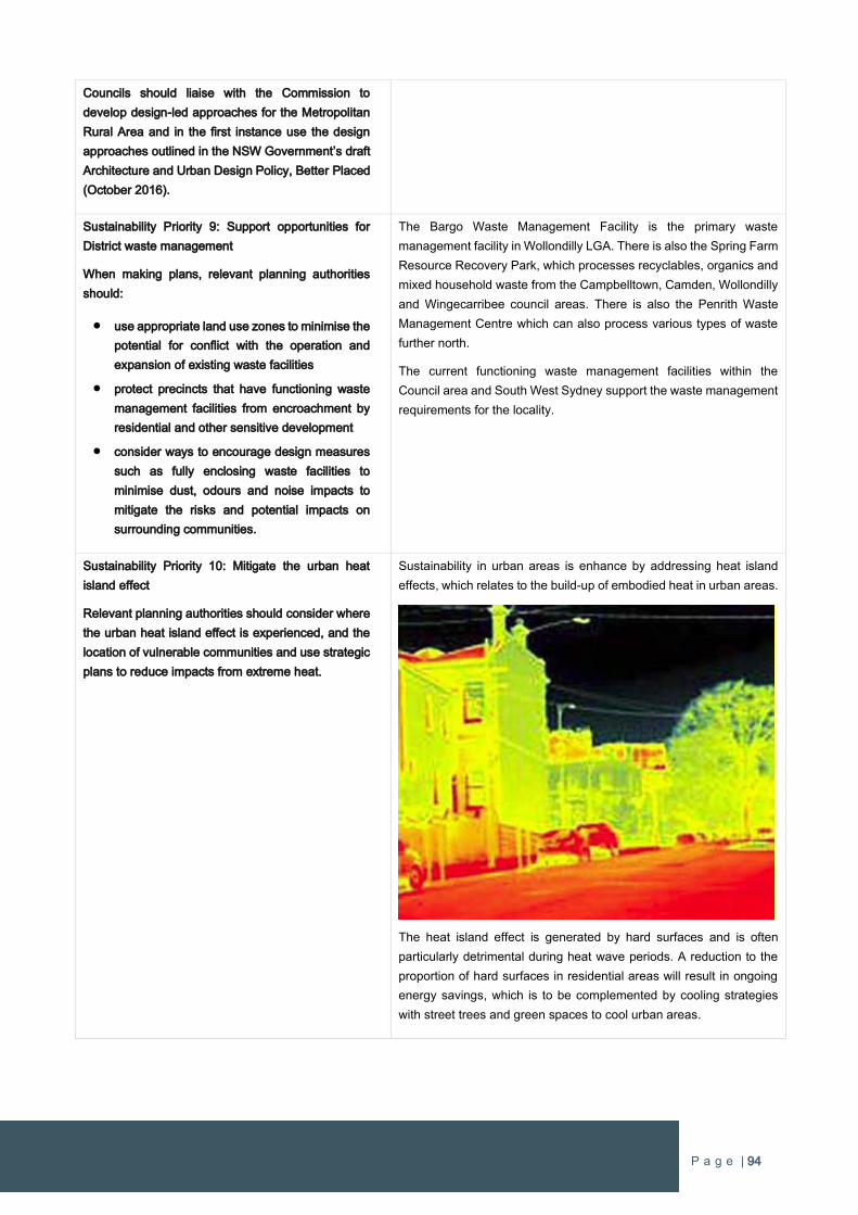
P a g e | 94
Councils should liaise with the Commission to
develop design-led approaches for the Metropolitan
Rural Area and in the first instance use the design
approaches outlined in the NSW Government’s draft
Architecture and Urban Design Policy, Better Placed
(October 2016).
Sustainability Priority 9: Support opportunities for
District waste management
When making plans, relevant planning authorities
should:
use appropriate land use zones to minimise the
potential for conflict with the operation and
expansion of existing waste facilities
protect precincts that have functioning waste
management facilities from encroachment by
residential and other sensitive development
consider ways to encourage design measures
such as fully enclosing waste facilities to
minimise dust, odours and noise impacts to
mitigate the risks and potential impacts on
surrounding communities.
The Bargo Waste Management Facility is the primary waste
management facility in Wollondilly LGA. There is also the Spring Farm
Resource Recovery Park, which processes recyclables, organics and
mixed household waste from the Campbelltown, Camden, Wollondilly
and Wingecarribee council areas. There is also the Penrith Waste
Management Centre which can also process various types of waste
further north.
The current functioning waste management facilities within the
Council area and South West Sydney support the waste management
requirements for the locality.
Sustainability Priority 10: Mitigate the urban heat
island effect
Relevant planning authorities should consider where
the urban heat island effect is experienced, and the
location of vulnerable communities and use strategic
plans to reduce impacts from extreme heat.
Sustainability in urban areas is enhance by addressing heat island
effects, which relates to the build-up of embodied heat in urban areas.
The heat island effect is generated by hard surfaces and is often
particularly detrimental during heat wave periods. A reduction to the
proportion of hard surfaces in residential areas will result in ongoing
energy savings, which is to be complemented by cooling strategies
with street trees and green spaces to cool urban areas.
P a g e | 95
Wilton West is to be covered with a green grid of local parks, green
spaces and the natural environment. There is also a large lake that
will have a positive cooling effect on the microclimate for residents
within Wilton West.
Sustainability Priority 11: Integrate land use and
transport planning to consider emergency
evacuation needs
Relevant planning authorities should coordinate with
Transport for NSW and the State Emergency Service
to consider land use and local road planning, so that
it is integrated with emergency evacuation planning
and takes into account the cumulative impact of
growth on road evacuation capacity.
Emergency services requirements were investigated as part of the
Wilton Junction planning process and form part of the development
contributions for urban development.
Wilton West will have numerous evacuation routes in the event of an
emergency evacuation procedure with direct connections to Picton
Road and the Hume Highway.
Sustainability Priority 12: Use buffers to manage the
impacts of rural activities on noise, odour and air
quality
When preparing strategic plans, relevant planning
authorities will:
work with the Environment Protection
Authority, Department of Primary Industries
and councils to identify approaches (that may
include buffers) for agriculture and primary
industry activities to manage land use conflict
use strategic plans to prevent or limit
development in areas that would be in conflict
with agriculture and primary industry
protect agriculture and primary industry
activities from encroachment by residential and
other sensitive development.
The mitigation measures in response to air quality, noise emissions
and odour has been considered as part of the Wilton Junction planning
process.
Wilton West has a natural buffer as it is mostly surrounded by a wide
band of bushland and major waterways, which provide a significant
separation with any rural activities. Accordingly, there will not be any
land use conflicts arising from urban development within Wilton West.
Sustainability Priority 13: Assist local communities
develop a coordinated understanding of natural
hazards and responses that reduce risk
The Commission, the NSW Government and local
councils will continue to adopt a range of tools,
resources and implement actions to adapt to climate
change and reduce risks to public and private assets.
The Commission will also explore ways to
coordinate, improve and communicate information
about risks associated with climate change to local
communities.
The design of Wilton West has been informed by various
investigations, in particular bushfire. This has influenced the location
of streets, local parks, schools and major road connections to ensure
any hazardous events or risks are managed properly to protect the
future population of Wilton West.
P a g e | 96
A Plan for Growing Sydney
In December 2014 the NSW Government published ‘A Plan for Growing Sydney’ which provides a strategic framework for urban
growth, infrastructure and transport throughout the Sydney Metropolitan Area. The Plan sets out the Government’s strategy for
meeting Sydney’s housing supply needs over the next 20 years identifying key focus areas.
Whilst there is no recent Subregional Strategy for South West Sydney, the Department of Planning & Environment has set itself four
goals to realise the vision for Greater Sydney.
Goal 1: A competitive economy with world-class services and transport;
Goal 2: A city of housing choice with homes that meet our needs and lifestyles;
Goal 3: A great place to live with communities that are strong, healthy and well connected;
Goal 4: A sustainable and resilient city that protects the natural environment and has a balanced approach to the use of
land and resources.
Whilst there is no recent Subregional Strategy for South West Sydney, the Sydney’s Metropolitan Strategy establishes South West
Sydney priorities.
Priorities for South West Subregion:
A competitive economy
Accelerate housing supply, choice and affordability and build great places to live
Protect the natural environment and promote its sustainability and resilience
The South West area of Sydney is noted as the fastest growing subregion of Metropolitan Sydney. The South West Priority Growth
Area continues to be the strongest contributor to new housing throughout Sydney and is a focus for new housing and jobs.
The South West is subject to numerous State infrastructure projects in planning and delivery phases. The South West also has strong
connections with the Western Sydney Airport, which will activate significant investment in infrastructure and jobs, and the
establishment of the Western Sydney Employment Area.
A Plan for Growing Sydney identifies approximately 17,600 hectares of land for investigation known as The Greater Macarthur
Investigation Area which incorporated Wilton, including the subject land holding (refer Figure 33). The Plan identified the need to
investigate land within Wollondilly Shire as part of the Macarthur South Investigation area for a future Growth Centre as part of
Sydney’s South West Subregion.
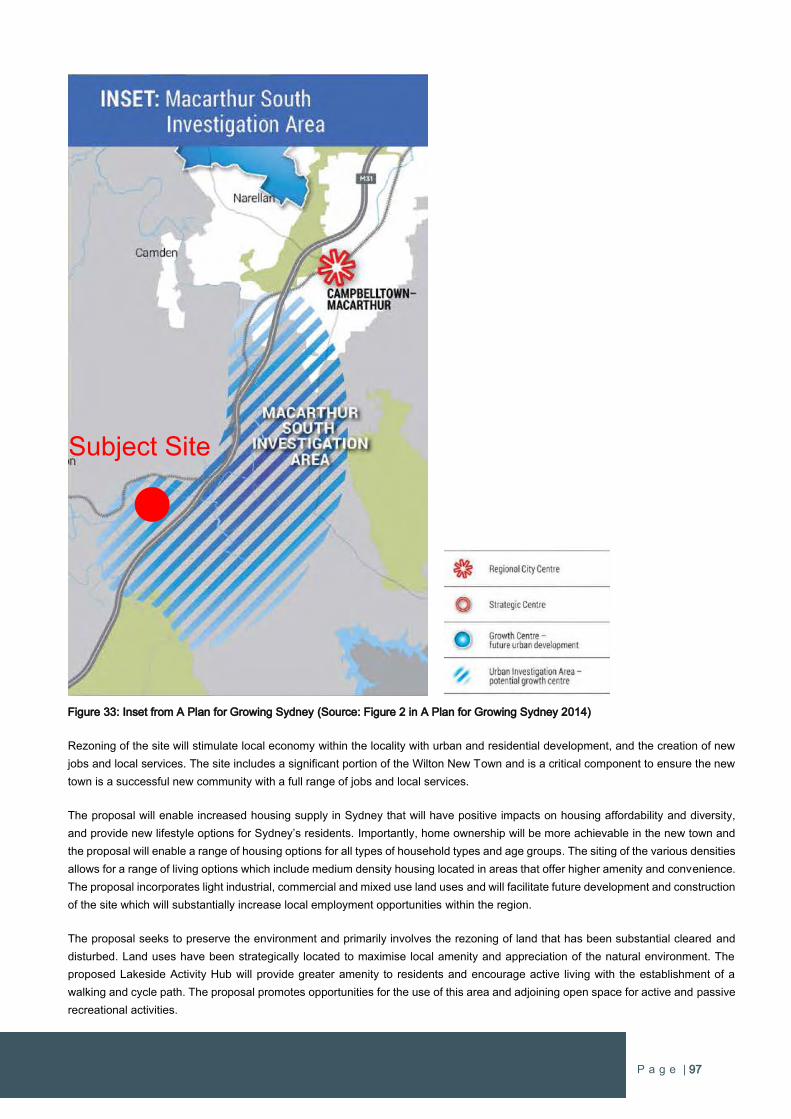
P a g e | 97
Figure 33: Inset from A Plan for Growing Sydney (Source: Figure 2 in A Plan for Growing Sydney 2014)
Rezoning of the site will stimulate local economy within the locality with urban and residential development, and the creation of new
jobs and local services. The site includes a significant portion of the Wilton New Town and is a critical component to ensure the new
town is a successful new community with a full range of jobs and local services.
The proposal will enable increased housing supply in Sydney that will have positive impacts on housing affordability and diversity,
and provide new lifestyle options for Sydney’s residents. Importantly, home ownership will be more achievable in the new town and
the proposal will enable a range of housing options for all types of household types and age groups. The siting of the various densities
allows for a range of living options which include medium density housing located in areas that offer higher amenity and convenience.
The proposal incorporates light industrial, commercial and mixed use land uses and will facilitate future development and construction
of the site which will substantially increase local employment opportunities within the region.
The proposal seeks to preserve the environment and primarily involves the rezoning of land that has been substantial cleared and
disturbed. Land uses have been strategically located to maximise local amenity and appreciation of the natural environment. The
proposed Lakeside Activity Hub will provide greater amenity to residents and encourage active living with the establishment of a
walking and cycle path. The proposal promotes opportunities for the use of this area and adjoining open space for active and passive
recreational activities.
Subject Site
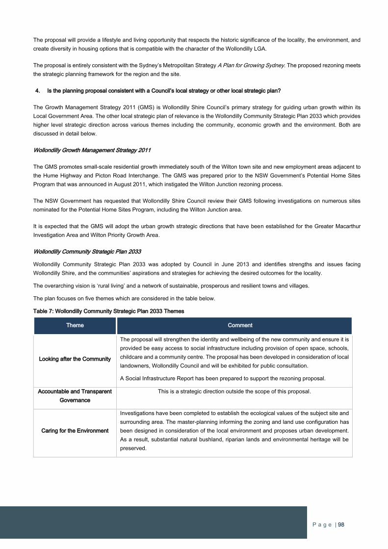
P a g e | 98
The proposal will provide a lifestyle and living opportunity that respects the historic significance of the locality, the environment, and
create diversity in housing options that is compatible with the character of the Wollondilly LGA.
The proposal is entirely consistent with the Sydney’s Metropolitan Strategy A Plan for Growing Sydney. The proposed rezoning meets
the strategic planning framework for the region and the site.
4. Is the planning proposal consistent with a Council’s local strategy or other local strategic plan?
The Growth Management Strategy 2011 (GMS) is Wollondilly Shire Council’s primary strategy for guiding urban growth within its
Local Government Area. The other local strategic plan of relevance is the Wollondilly Community Strategic Plan 2033 which provides
higher level strategic direction across various themes including the community, economic growth and the environment. Both are
discussed in detail below.
Wollondilly Growth Management Strategy 2011
The GMS promotes small-scale residential growth immediately south of the Wilton town site and new employment areas adjacent to
the Hume Highway and Picton Road Interchange. The GMS was prepared prior to the NSW Government’s Potential Home Sites
Program that was announced in August 2011, which instigated the Wilton Junction rezoning process.
The NSW Government has requested that Wollondilly Shire Council review their GMS following investigations on numerous sites
nominated for the Potential Home Sites Program, including the Wilton Junction area.
It is expected that the GMS will adopt the urban growth strategic directions that have been established for the Greater Macarthur
Investigation Area and Wilton Priority Growth Area.
Wollondilly Community Strategic Plan 2033
Wollondilly Community Strategic Plan 2033 was adopted by Council in June 2013 and identifies strengths and issues facing
Wollondilly Shire, and the communities’ aspirations and strategies for achieving the desired outcomes for the locality.
The overarching vision is ‘rural living’ and a network of sustainable, prosperous and resilient towns and villages.
The plan focuses on five themes which are considered in the table below.
Table 7: Wollondilly Community Strategic Plan 2033 Themes
Theme Comment
Looking after the Community
The proposal will strengthen the identity and wellbeing of the new community and ensure it is
provided be easy access to social infrastructure including provision of open space, schools,
childcare and a community centre. The proposal has been developed in consideration of local
landowners, Wollondilly Council and will be exhibited for public consultation.
A Social Infrastructure Report has been prepared to support the rezoning proposal.
Accountable and Transparent
Governance
This is a strategic direction outside the scope of this proposal.
Caring for the Environment
Investigations have been completed to establish the ecological values of the subject site and
surrounding area. The master-planning informing the zoning and land use configuration has
been designed in consideration of the local environment and proposes urban development.
As a result, substantial natural bushland, riparian lands and environmental heritage will be
preserved.
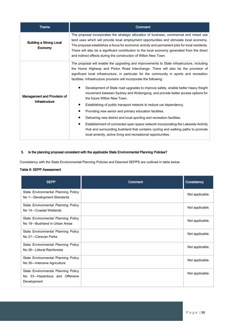
P a g e | 99
Theme Comment
Building a Strong Local
Economy
The proposal incorporates the strategic allocation of business, commercial and mixed use
land uses which will provide local employment opportunities and stimulate local economy.
The proposal establishes a focus for economic activity and permanent jobs for local residents.
There will also be a significant contribution to the local economy generated from the direct
and indirect effects during the construction of Wilton New Town.
Management and Provision of
Infrastructure
The proposal will enable the upgrading and improvements to State infrastructure, including
the Hume Highway and Picton Road Interchange. There will also be the provision of
significant local infrastructure, in particular for the community in sports and recreation
facilities. Infrastructure provision will incorporate the following:
Development of State road upgrades to improve safety, enable better heavy freight
movement between Sydney and Wollongong, and provide better access options for
the future Wilton New Town.
Establishing of public transport network to reduce car dependency.
Providing new senior and primary education facilities.
Delivering new district and local sporting and recreation facilities.
Establishment of connected open space network incorporating the Lakeside Activity
Hub and surrounding bushland that contains cycling and walking paths to promote
local amenity, active living and recreational opportunities.
5. Is the planning proposal consistent with the applicable State Environmental Planning Policies?
Consistency with the State Environmental Planning Policies and Deemed SEPPS are outlined in table below.
Table 8: SEPP Assessment
SEPP Comment Consistency
State Environmental Planning Policy
No 1—Development Standards Not applicable.
State Environmental Planning Policy
No 14—Coastal Wetlands
Not applicable.
State Environmental Planning Policy
No 19—Bushland in Urban Areas
Not applicable.
State Environmental Planning Policy
No 21—Caravan Parks
Not applicable.
State Environmental Planning Policy
No 26—Littoral Rainforests
Not applicable.
State Environmental Planning Policy
No 30—Intensive Agriculture
Not applicable.
State Environmental Planning Policy
No 33—Hazardous and Offensive
Development
Not applicable.
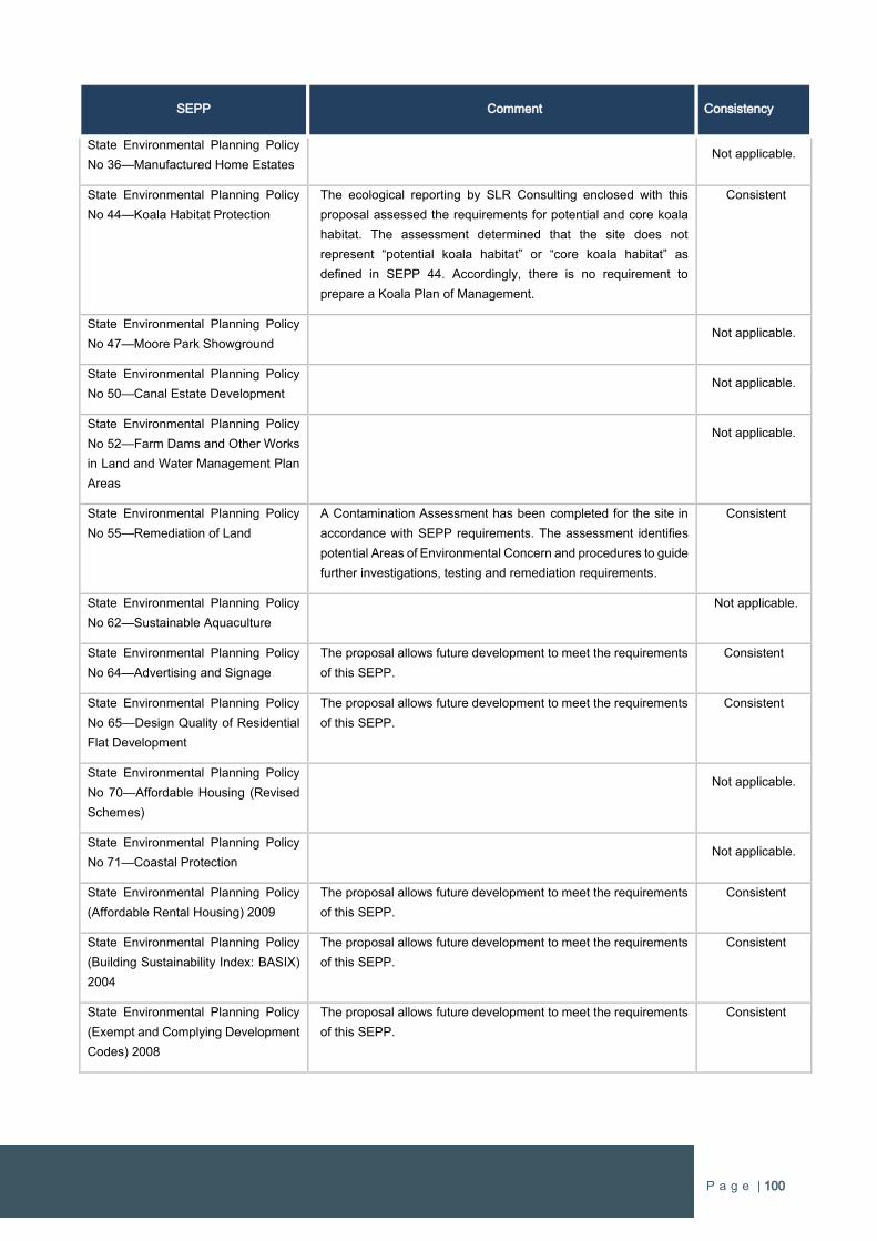
P a g e | 100
SEPP Comment Consistency
State Environmental Planning Policy
No 36—Manufactured Home Estates
Not applicable.
State Environmental Planning Policy
No 44—Koala Habitat Protection
The ecological reporting by SLR Consulting enclosed with this
proposal assessed the requirements for potential and core koala
habitat. The assessment determined that the site does not
represent “potential koala habitat” or “core koala habitat” as
defined in SEPP 44. Accordingly, there is no requirement to
prepare a Koala Plan of Management.
Consistent
State Environmental Planning Policy
No 47—Moore Park Showground
Not applicable.
State Environmental Planning Policy
No 50—Canal Estate Development
Not applicable.
State Environmental Planning Policy
No 52—Farm Dams and Other Works
in Land and Water Management Plan
Areas
Not applicable.
State Environmental Planning Policy
No 55—Remediation of Land
A Contamination Assessment has been completed for the site in
accordance with SEPP requirements. The assessment identifies
potential Areas of Environmental Concern and procedures to guide
further investigations, testing and remediation requirements.
Consistent
State Environmental Planning Policy
No 62—Sustainable Aquaculture
Not applicable.
State Environmental Planning Policy
No 64—Advertising and Signage
The proposal allows future development to meet the requirements
of this SEPP.
Consistent
State Environmental Planning Policy
No 65—Design Quality of Residential
Flat Development
The proposal allows future development to meet the requirements
of this SEPP.
Consistent
State Environmental Planning Policy
No 70—Affordable Housing (Revised
Schemes)
Not applicable.
State Environmental Planning Policy
No 71—Coastal Protection
Not applicable.
State Environmental Planning Policy
(Affordable Rental Housing) 2009
The proposal allows future development to meet the requirements
of this SEPP.
Consistent
State Environmental Planning Policy
(Building Sustainability Index: BASIX)
2004
The proposal allows future development to meet the requirements
of this SEPP.
Consistent
State Environmental Planning Policy
(Exempt and Complying Development
Codes) 2008
The proposal allows future development to meet the requirements
of this SEPP.
Consistent
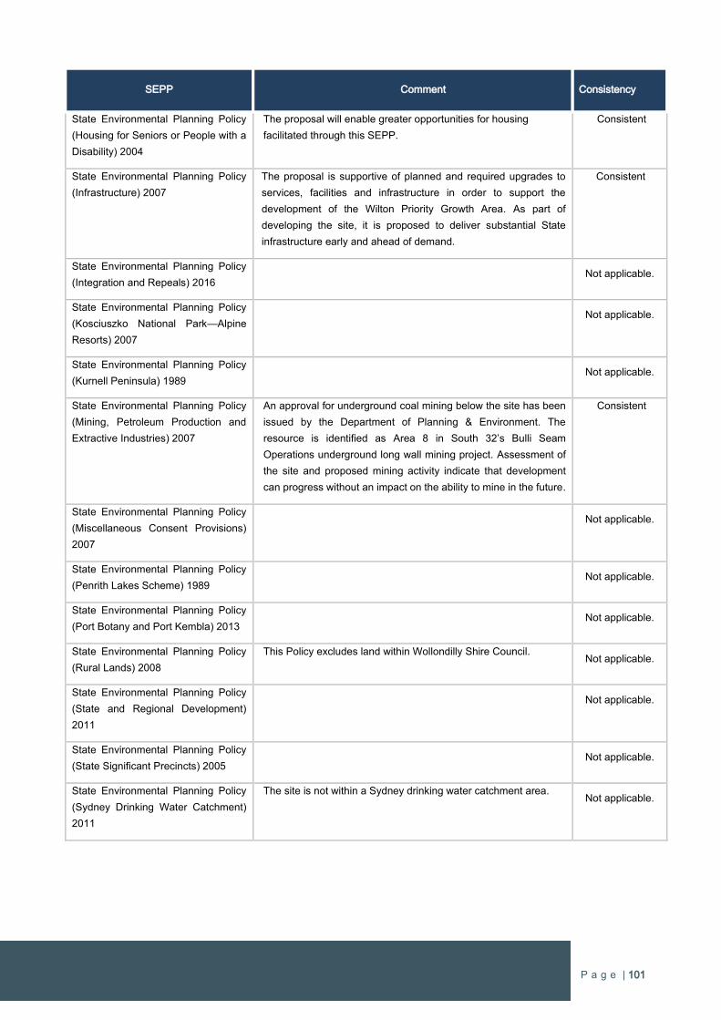
P a g e | 101
SEPP Comment Consistency
State Environmental Planning Policy
(Housing for Seniors or People with a
Disability) 2004
The proposal will enable greater opportunities for housing
facilitated through this SEPP.
Consistent
State Environmental Planning Policy
(Infrastructure) 2007
The proposal is supportive of planned and required upgrades to
services, facilities and infrastructure in order to support the
development of the Wilton Priority Growth Area. As part of
developing the site, it is proposed to deliver substantial State
infrastructure early and ahead of demand.
Consistent
State Environmental Planning Policy
(Integration and Repeals) 2016
Not applicable.
State Environmental Planning Policy
(Kosciuszko National Park—Alpine
Resorts) 2007
Not applicable.
State Environmental Planning Policy
(Kurnell Peninsula) 1989
Not applicable.
State Environmental Planning Policy
(Mining, Petroleum Production and
Extractive Industries) 2007
An approval for underground coal mining below the site has been
issued by the Department of Planning & Environment. The
resource is identified as Area 8 in South 32’s Bulli Seam
Operations underground long wall mining project. Assessment of
the site and proposed mining activity indicate that development
can progress without an impact on the ability to mine in the future.
Consistent
State Environmental Planning Policy
(Miscellaneous Consent Provisions)
2007
Not applicable.
State Environmental Planning Policy
(Penrith Lakes Scheme) 1989
Not applicable.
State Environmental Planning Policy
(Port Botany and Port Kembla) 2013
Not applicable.
State Environmental Planning Policy
(Rural Lands) 2008
This Policy excludes land within Wollondilly Shire Council. Not applicable.
State Environmental Planning Policy
(State and Regional Development)
2011
Not applicable.
State Environmental Planning Policy
(State Significant Precincts) 2005
Not applicable.
State Environmental Planning Policy
(Sydney Drinking Water Catchment)
2011
The site is not within a Sydney drinking water catchment area. Not applicable.

P a g e | 102
SEPP Comment Consistency
State Environmental Planning Policy
(Sydney Region Growth Centres)
2006
The Wilton Priority Growth Area is now a ‘Growth Centre’ under
the State Environmental Planning Policy (Sydney Region Growth
Centres) 2006 as a result of the recent declaration of the SEPP,
which was Gazetted on Friday 29 August 2016. The proposal is
being facilitated through this SEPP to amend Wollondilly LEP
2011.
Consistent
State Environmental Planning Policy
(Three Ports) 2013
Not applicable.
State Environmental Planning Policy
(Urban Renewal) 2010
Not applicable.
State Environmental Planning Policy
(Western Sydney Employment Area)
2009
Not applicable.
State Environmental Planning Policy
(Western Sydney Parklands) 2009
Not applicable.
Sydney Regional Environmental Plan
No 8 (Central Coast Plateau Areas)
Not applicable.
Sydney Regional Environmental Plan
No 9—Extractive Industry (No 2—
1995)
Not applicable.
Sydney Regional Environmental Plan
No 16—Walsh Bay
Not applicable.
Sydney Regional Environmental Plan
No 20—Hawkesbury-Nepean River
(No 2—1997)
The Nepean River is located north and west of the subject site. The
Wilton Junction Masterplan has been designed to preserve the
natural environment that interfaces between the Nepean River and
its tributaries with future urban development. The investigations
supporting this proposal consider the biodiversity and Aboriginal
heritage of the site to ensure appropriate environmental standards
are achieved. Environmental management to be adopted during
construction will need to prevent impacts on the Nepean River.
Consistent
Sydney Regional Environmental Plan
No 24—Homebush Bay Area
Not applicable.
Sydney Regional Environmental Plan
No 26—City West
Not applicable.
Sydney Regional Environmental Plan
No 30—St Marys
Not applicable.
Sydney Regional Environmental Plan
No 33—Cooks Cove
Not applicable.
Sydney Regional Environmental Plan
(Sydney Harbour Catchment) 2005
Not applicable.
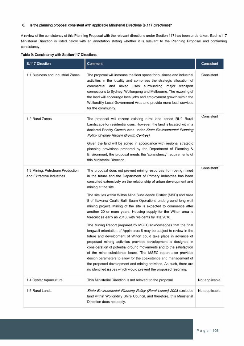
P a g e | 103
6. Is the planning proposal consistent with applicable Ministerial Directions (s.117 directions)?
A review of the consistency of this Planning Proposal with the relevant directions under Section 117 has been undertaken. Each s117
Ministerial Direction is listed below with an annotation stating whether it is relevant to the Planning Proposal and confirming
consistency.
Table 9: Consistency with Section117 Directions
S.117 Direction Comment Consistent
1.1 Business and Industrial Zones The proposal will increase the floor space for business and industrial
activities in the locality and comprises the strategic allocation of
commercial and mixed uses surrounding major transport
connections to Sydney, Wollongong and Melbourne. The rezoning of
the land will encourage local jobs and employment growth within the
Wollondilly Local Government Area and provide more local services
for the community.
Consistent
1.2 Rural Zones The proposal will rezone existing rural land zoned RU2 Rural
Landscape for residential uses. However, the land is located within a
declared Priority Growth Area under State Environmental Planning
Policy (Sydney Region Growth Centres).
Given the land will be zoned in accordance with regional strategic
planning provisions prepared by the Department of Planning &
Environment, the proposal meets the ‘consistency’ requirements of
this Ministerial Direction.
Consistent
1.3 Mining, Petroleum Production
and Extractive Industries
The proposal does not prevent mining resources from being mined
in the future and the Department of Primary Industries has been
consulted extensively on the relationship of urban development and
mining at the site.
The site lies within Wilton Mine Subsidence District (MSD) and Area
8 of Illawarra Coal’s Bulli Seam Operations underground long wall
mining project. Mining of the site is expected to commence after
another 20 or more years. Housing supply for the Wilton area is
forecast as early as 2018, with residents by late 2018.
The Mining Report prepared by MSEC acknowledges that the final
longwall orientation of Appin area 8 may be subject to review in the
future and development of Wilton could take place in advance of
proposed mining activities provided development is designed in
consideration of potential ground movements and to the satisfaction
of the mine subsidence board. The MSEC report also provides
design parameters to allow for the coexistence and management of
the proposed development and mining activities. As such, there are
no identified issues which would prevent the proposed rezoning.
Consistent
1.4 Oyster Aquaculture This Ministerial Direction is not relevant to the proposal. Not applicable.
1.5 Rural Lands State Environmental Planning Policy (Rural Lands) 2008 excludes
land within Wollondilly Shire Council, and therefore, this Ministerial
Direction does not apply.
Not applicable.
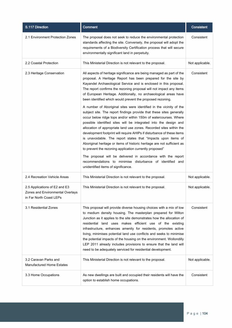
P a g e | 104
S.117 Direction Comment Consistent
2.1 Environment Protection Zones The proposal does not seek to reduce the environmental protection
standards affecting the site. Conversely, the proposal will adopt the
requirements of a Biodiversity Certification process that will secure
environmentally significant land in perpetuity.
Consistent
2.2 Coastal Protection This Ministerial Direction is not relevant to the proposal. Not applicable.
2.3 Heritage Conservation All aspects of heritage significance are being managed as part of the
proposal. A Heritage Report has been prepared for the site by
Kayandel Archaeological Service and is enclosed in this proposal.
The report confirms the rezoning proposal will not impact any items
of European Heritage. Additionally, no archaeological areas have
been identified which would prevent the proposed rezoning.
A number of Aboriginal sites were identified in the vicinity of the
subject site. The report findings provide that these sites generally
occur below ridge tops and/or within 150m of watercourses. Where
possible identified sites will be integrated into the design and
allocation of appropriate land use zones. Recorded sites within the
development footprint will require AHIPs if disturbance of these items
is unavoidable. The report states that “Impacts upon items of
Aboriginal heritage or items of historic heritage are not sufficient as
to prevent the rezoning application currently proposed”
The proposal will be delivered in accordance with the report
recommendations to minimise disturbance of identified and
unidentified items of significance.
Consistent
2.4 Recreation Vehicle Areas This Ministerial Direction is not relevant to the proposal. Not applicable.
2.5 Applications of E2 and E3
Zones and Environmental Overlays
in Far North Coast LEPs
This Ministerial Direction is not relevant to the proposal. Not applicable.
3.1 Residential Zones This proposal will provide diverse housing choices with a mix of low
to medium density housing. The masterplan prepared for Wilton
Junction as it applies to the site demonstrates how the allocation of
residential land uses makes efficient use of the existing
infrastructure, enhances amenity for residents, promotes active
living, minimises potential land use conflicts and seeks to minimise
the potential impacts of the housing on the environment. Wollondilly
LEP 2011 already includes provisions to ensure that the land will
need to be adequately serviced for residential development.
Consistent
3.2 Caravan Parks and
Manufactured Home Estates
This Ministerial Direction is not relevant to the proposal. Not applicable.
3.3 Home Occupations As new dwellings are built and occupied their residents will have the
option to establish home occupations.
Consistent
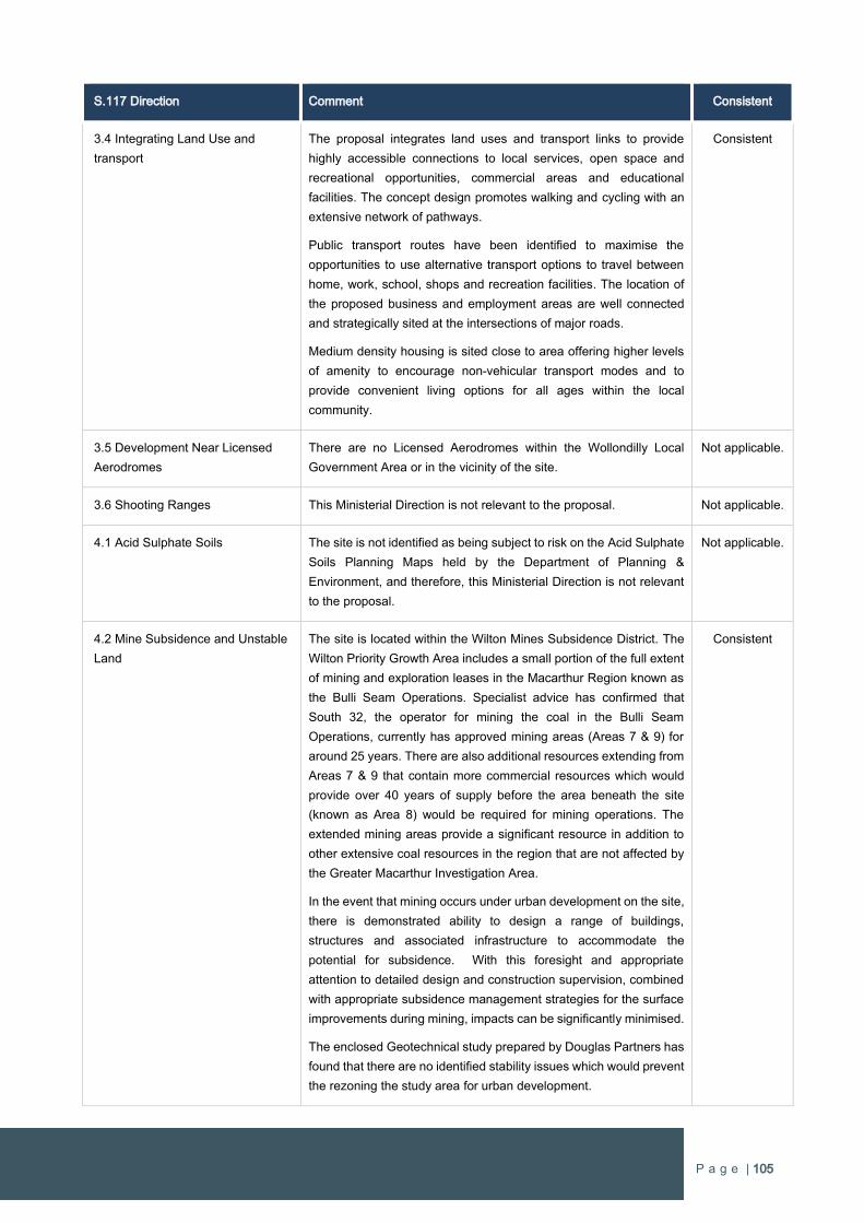
P a g e | 105
S.117 Direction Comment Consistent
3.4 Integrating Land Use and
transport
The proposal integrates land uses and transport links to provide
highly accessible connections to local services, open space and
recreational opportunities, commercial areas and educational
facilities. The concept design promotes walking and cycling with an
extensive network of pathways.
Public transport routes have been identified to maximise the
opportunities to use alternative transport options to travel between
home, work, school, shops and recreation facilities. The location of
the proposed business and employment areas are well connected
and strategically sited at the intersections of major roads.
Medium density housing is sited close to area offering higher levels
of amenity to encourage non-vehicular transport modes and to
provide convenient living options for all ages within the local
community.
Consistent
3.5 Development Near Licensed
Aerodromes
There are no Licensed Aerodromes within the Wollondilly Local
Government Area or in the vicinity of the site.
Not applicable.
3.6 Shooting Ranges This Ministerial Direction is not relevant to the proposal. Not applicable.
4.1 Acid Sulphate Soils The site is not identified as being subject to risk on the Acid Sulphate
Soils Planning Maps held by the Department of Planning &
Environment, and therefore, this Ministerial Direction is not relevant
to the proposal.
Not applicable.
4.2 Mine Subsidence and Unstable
Land
The site is located within the Wilton Mines Subsidence District. The
Wilton Priority Growth Area includes a small portion of the full extent
of mining and exploration leases in the Macarthur Region known as
the Bulli Seam Operations. Specialist advice has confirmed that
South 32, the operator for mining the coal in the Bulli Seam
Operations, currently has approved mining areas (Areas 7 & 9) for
around 25 years. There are also additional resources extending from
Areas 7 & 9 that contain more commercial resources which would
provide over 40 years of supply before the area beneath the site
(known as Area 8) would be required for mining operations. The
extended mining areas provide a significant resource in addition to
other extensive coal resources in the region that are not affected by
the Greater Macarthur Investigation Area.
In the event that mining occurs under urban development on the site,
there is demonstrated ability to design a range of buildings,
structures and associated infrastructure to accommodate the
potential for subsidence. With this foresight and appropriate
attention to detailed design and construction supervision, combined
with appropriate subsidence management strategies for the surface
improvements during mining, impacts can be significantly minimised.
The enclosed Geotechnical study prepared by Douglas Partners has
found that there are no identified stability issues which would prevent
the rezoning the study area for urban development.
Consistent
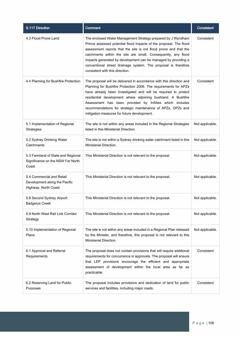
P a g e | 106
S.117 Direction Comment Consistent
4.3 Flood Prone Land The enclosed Water Management Strategy prepared by J Wyndham
Prince assessed potential flood impacts of the proposal. The flood
assessment reports that the site is not flood prone and that the
catchments within the site are small. Consequently, any flood
impacts generated by development can be managed by providing a
conventional street drainage system. The proposal is therefore
consistent with this direction.
Consistent
4.4 Planning for Bushfire Protection The proposal will be delivered in accordance with this direction and
Planning for Bushfire Protection 2006. The requirements for APZs
have already been investigated and will be required to protect
residential development where adjoining bushland. A Bushfire
Assessment has been provided by InSites which includes
recommendations for strategic maintenance of APZs, OPZs and
mitigation measures for future development.
Consistent
5.1 Implementation of Regional
Strategies
The site is not within any areas included in the Regional Strategies
listed in this Ministerial Direction.
Not applicable.
5.2 Sydney Drinking Water
Catchments
The site is not within a Sydney drinking water catchment listed in this
Ministerial Direction.
Not applicable.
5.3 Farmland of State and Regional
Significance on the NSW Far North
Coast
This Ministerial Direction is not relevant to the proposal. Not applicable.
5.4 Commercial and Retail
Development along the Pacific
Highway, North Coast
This Ministerial Direction is not relevant to the proposal. Not applicable.
5.8 Second Sydney Airport:
Badgerys Creek
This Ministerial Direction is not relevant to the proposal. Not applicable.
5.9 North West Rail Link Corridor
Strategy
This Ministerial Direction is not relevant to the proposal. Not applicable.
5.10 Implementation of Regional
Plans
The site is not within any areas included in a Regional Plan released
by the Minister, and therefore, this proposal is not relevant to this
Ministerial Direction.
Not applicable.
6.1 Approval and Referral
Requirements
The proposal does not contain provisions that will require additional
requirements for concurrence in approvals. The proposal will ensure
that LEP provisions encourage the efficient and appropriate
assessment of development within the local area as far as
practicable.
Consistent
6.2 Reserving Land for Public
Purposes
The proposal includes provisions and dedication of land for public
services and facilities, including major roads.
Consistent
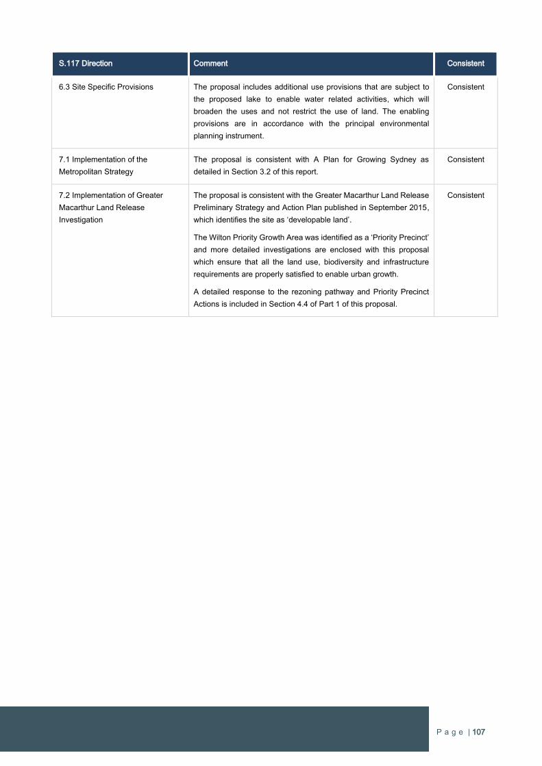
P a g e | 107
S.117 Direction Comment Consistent
6.3 Site Specific Provisions The proposal includes additional use provisions that are subject to
the proposed lake to enable water related activities, which will
broaden the uses and not restrict the use of land. The enabling
provisions are in accordance with the principal environmental
planning instrument.
Consistent
7.1 Implementation of the
Metropolitan Strategy
The proposal is consistent with A Plan for Growing Sydney as
detailed in Section 3.2 of this report.
Consistent
7.2 Implementation of Greater
Macarthur Land Release
Investigation
The proposal is consistent with the Greater Macarthur Land Release
Preliminary Strategy and Action Plan published in September 2015,
which identifies the site as ‘developable land’.
The Wilton Priority Growth Area was identified as a ‘Priority Precinct’
and more detailed investigations are enclosed with this proposal
which ensure that all the land use, biodiversity and infrastructure
requirements are properly satisfied to enable urban growth.
A detailed response to the rezoning pathway and Priority Precinct
Actions is included in Section 4.4 of Part 1 of this proposal.
Consistent
P a g e | 108
3.3 Section C – Environmental, social and economic impact
7. Is there any likelihood that critical habitat or threatened species, populations or ecological communities, or their habitats, will be
adversely affected as a result of the proposal?
An assessment of significance has been undertaken for the site and identified the various ecological communities and their level of
environmental significance. There have also been specific assessments on native grassland communities.
Due to the scale of the area being rezoned, the proposal is to run concurrently with a Biodiversity Certification process that will address
the management of ecological communities and resolve options for offsetting impacts on biodiversity at the early planning stages.
Once the Biodiversity Certification is formalised, assessment and determination of Development Applications will be exempt from the
relevant requirements under the Environmental Planning and Assessment Act 1979 and site specific assessment under the
Threatened Species Conservation Act 1995.
8. Are there any other likely environmental effects as a result of the planning proposal and how are they proposed to be managed?
As a result of the proposal bushfire mitigation measures will need to be implemented in the future. This will involve the establishment
of Outer Protection Zones within bushland adjoining developable land. This mitigation measure has been recommended under
Planning for bushfires 2006. All future development will need to comply with the mitigation measures proposed to manage bushfire
safety.
Though substantially disturbed a number of Aboriginal sites have been identified in the vicinity of the site. The Heritage Report
prepared by Kayandel Archaeological Services confirms these findings are not sufficient to prevent the rezoning, however further
assessment will be required prior to development to determine whether items can be integrated and conserved in open space areas
or whether an AHIP will be required.
9. Has the planning proposal adequately addressed any social and economic effects?
Comprehensive assessments on the economic and social impacts associated with the rezoning of land have been undertaken by
Macroplan Dimasi in relation to economic impacts and Elton Consulting in regard to social impacts. The respective assessments
confirm that urban development of the site will result in positive social and economic effects and no detrimental impacts.
MacroPlan Dimasi prepared an Economic Development & Employment Strategy as part of the Wilton Junction rezoning process,
which is enclosed with this proposal. This report considered the economic potential for different types of business activities with a
focus on industries that are predominantly population driven including retail, social infrastructure, health care, education and public
administration, employment will evolve sequentially with population growth.
The report provides employment strategies for sector specific industries including health, education, construction, transport, postal
and warehousing, tourism and recreation and agribusiness. The success of the strategies will be dependent on: the quality and
inventiveness of specific marketing material, appropriate implementation structures and arrangements and the ongoing ownership
and refinement of the initiatives.
As detailed in Part 1 of this Planning Proposal, MacroPlan Dimasi has also prepared an Employment Strategy (refer Appendix 1) to
ensure the early delivery and targeted job growth from day 1 of construction. This Employment Strategy sets a framework for creating
new employment throughout the lifecycle of Wilton West. There will be significant economic and social benefits arising from the
Strategy with a push to establish specific employment uses to stimulate local economic to drive job creation.
There will be important social benefits from the Employment Strategy as it will enable people to work close to where they live. It will
also provide opportunities for post-school training in construction jobs to assist in establishing a localised skilled workfare for the
construction industry throughout the development lifecycle of Wilton New Town.

P a g e | 109
The proposal site is projected to contain over 16,000 people which will require extensive social infrastructure to support healthy living
and quality lifestyles. Importantly this needs to include the recreational, health and entertainment facilities to maximise the liveability
of the new community. The proposal includes delivery of a range of new district and local social infrastructure within the site including:
Private K-12 school
Public Primary School
Two double playing fields
Over 20ha of active open space
Over 25ha of passive open space
In addition, the proponent is willing to accommodate a new Public K-12 School for Wilton New Town if there is demand and it cannot
be provided elsewhere within the Wilton Priority Growth Area. The Lakeside Activity Hub is to contain a significant health services
component and there will also be extensive pathways, picnic and recreational facilities, and child cares services.
The following positive effects will result from the rezoning:
Additional supply in housing.
a diverse range of housing types that capture a full socio-economic mix of people of all ages and family type.
Generation of local employment opportunities.
Establishment of and upgrades to local community facilities, open space and infrastructure.
The proposal will attract more people to Wilton New Town and will support the economic viability of the entire community with
accelerated employment and housing growth.
P a g e | 110
3.4 Section D – State and Commonwealth Interests
10. Is there adequate public infrastructure for the planning proposal?
The State and local infrastructure requirements were comprehensively investigated and determined as part of the Wilton Junction
rezoning process, which included extensive consultation with Government Departments and agencies, and service providers.
A proponent infrastructure offer was presented to the Government in July 2015 as part of the Wilton Junction rezoning. The total value
of the Wilton Junction proponent offer was $178.5M, which includes $45M of additional funds requested by the Department of Planning
& Environment that is related to Wilton Junction. The offer also included land dedicated for conservation purposes.
The offer was structured so infrastructure could be provided individually by the three largest landowners in the Wilton Priority Growth
Area (excluding Lend Lease) given the critical mass generated by their respective projects. Various infrastructure items were allocated
to these landowners based on the development capacity of each respective individual project.
It is proposed to provide certain State infrastructure early to ensure delivery will always be ahead of demand throughout the life of the
project. The schedule for infrastructure delivery will result in over 70% of the State infrastructure requirements being delivered when
only 23% of the urban development has occurred. This results in the last 77% of the development to support the remaining 30% of
State infrastructure.
Contributions for State road infrastructure that have been established for Wilton Junction require upgrading to the Hume
Highway/Picton Road Interchange and the provision of new off and on-ramps. This will ensure the performance of the Interchange
improves by separating the traffic generated from Wilton New Town and the heavy freight vehicles traveling between the Wollongong
and Sydney regions. These works also include the provision of a pedestrian bridge over the Hume Highway to enable a pedestrian
and cycling transport connection to Bingara Gorge.
The opportunity to improve connectivity with Wilton New Town by incorporating an additional off-ramp from the Hume Highway that
provides a direct access route to the northern areas of Bingara Gorge and Wilton West is another component of important State
infrastructure. The additional off-ramp from the Hume Highway has evolved out of the planning undertaken during the Wilton Junction
planning process. The new direct access arrangement establishes a strategic road connection directly off the Hume Highway that will
reduce traffic on the exiting Hume Highway/Picton Road interchange and increase options for accessing Wilton New Town. The
proposed on-ramp within Wilton West would also be delivered to ensure easy access in the northbound direction. This will deliver a
well-connected road network that achieves a host of wide-ranging benefits to serve the Wilton New Town community as it grows.
Water is to be provided under a commercial agreement with Sydney Water and a site for a reservoir has been identified on elevated
land within the Walker Corporation land, which also forms part of the Wilton Priority Growth Area. Wastewater infrastructure will be
provided under a commercial agreement with Sydney Water or an approved licensed operator.
Education requirements were determined as part of the Wilton Junction investigations and established that a Public K-12 school and
two primary schools. The site has a Private K-12 school and one of the Public primary schools. The proponent has a contracted
provider for the Private K-12 school and the primary school in the north of the site will need to be delivered in the medium to long
term. In the event that there is a demand to establish a Public K-12 school, which was to be located in closer proximity to the Town
Centre, and development within the other areas of Wilton New Town is not progressing, the proponent would be agreeable to deliver
this essential educational infrastructure item.
It is noted that the other two major landowners will also have capacity to deliver major State infrastructure in the Wilton New Town. It
is anticipated that the respective infrastructure items will be allocated as has been determined during the Wilton Junction planning
process. It is expected that the smaller landholdings located within the Wilton PGA will need to make contributions through the SIC.
A staging schedule has been developed to set a framework for the staged infrastructure commitments and delivery. Given the site is
estimated to deliver over 5,400 residential allotments, it is programmed that most of the State infrastructure is delivered in the early
stages of the urban development.
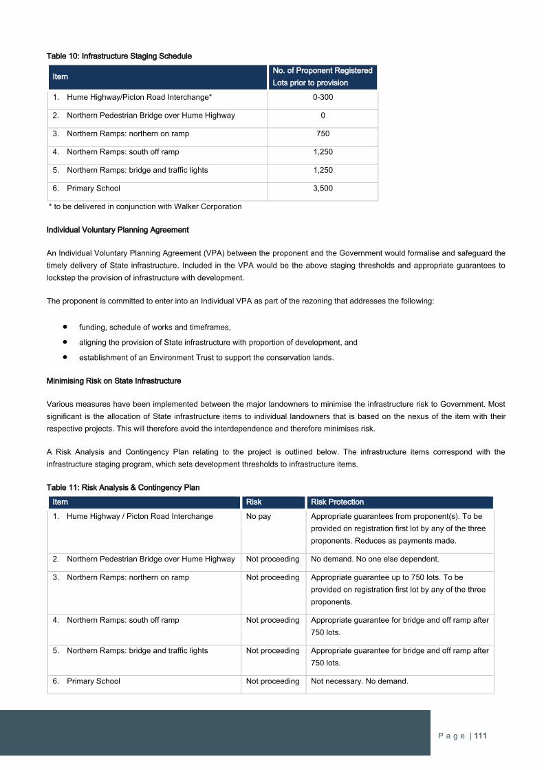
P a g e | 111
Table 10: Infrastructure Staging Schedule
Item No. of Proponent Registered
Lots prior to provision
1. Hume Highway/Picton Road Interchange* 0-300
2. Northern Pedestrian Bridge over Hume Highway 0
3. Northern Ramps: northern on ramp 750
4. Northern Ramps: south off ramp 1,250
5. Northern Ramps: bridge and traffic lights 1,250
6. Primary School 3,500
* to be delivered in conjunction with Walker Corporation
Individual Voluntary Planning Agreement
An Individual Voluntary Planning Agreement (VPA) between the proponent and the Government would formalise and safeguard the
timely delivery of State infrastructure. Included in the VPA would be the above staging thresholds and appropriate guarantees to
lockstep the provision of infrastructure with development.
The proponent is committed to enter into an Individual VPA as part of the rezoning that addresses the following:
funding, schedule of works and timeframes,
aligning the provision of State infrastructure with proportion of development, and
establishment of an Environment Trust to support the conservation lands.
Minimising Risk on State Infrastructure
Various measures have been implemented between the major landowners to minimise the infrastructure risk to Government. Most
significant is the allocation of State infrastructure items to individual landowners that is based on the nexus of the item with their
respective projects. This will therefore avoid the interdependence and therefore minimises risk.
A Risk Analysis and Contingency Plan relating to the project is outlined below. The infrastructure items correspond with the
infrastructure staging program, which sets development thresholds to infrastructure items.
Table 11: Risk Analysis & Contingency Plan
Item Risk Risk Protection
1. Hume Highway / Picton Road Interchange No pay Appropriate guarantees from proponent(s). To be
provided on registration first lot by any of the three
proponents. Reduces as payments made.
2. Northern Pedestrian Bridge over Hume Highway Not proceeding No demand. No one else dependent.
3. Northern Ramps: northern on ramp Not proceeding Appropriate guarantee up to 750 lots. To be
provided on registration first lot by any of the three
proponents.
4. Northern Ramps: south off ramp Not proceeding Appropriate guarantee for bridge and off ramp after
750 lots.
5. Northern Ramps: bridge and traffic lights Not proceeding Appropriate guarantee for bridge and off ramp after
750 lots.
6. Primary School Not proceeding Not necessary. No demand.
P a g e | 112
The Infrastructure Staging Schedule included in the VPA combined with Risk Analysis and Contingency Plan means that the
proponent will have funded 70 percent of the State infrastructure costs at the registration of 1,250 residential allotments, which
represents 23 percent of the development. In the event that the Public K-12 school is included into the site because others are not
developing, then the proponent will have funded 90 percent of the State infrastructure.
At every stage of the development the funding of State infrastructure is significantly forward of the demand generated by the new
urban growth and this is secured in a legally binding agreement. Therefore, it can be assured that infrastructure delivery and ‘at no
additional cost to Government’ imperatives are met with minimal risk to Government.
11. What are the views of the state and Commonwealth public authorities consulted in accordance with the Gateway determination?
The proposed rezoning of the site has already undergone a thorough consultation process with Government Departments and
agencies as part of the Wilton Junction rezoning proposal.
Director General’s Requirements were issued in May 2013 to establish requirements for specialist investigations to inform the rezoning
of Wilton Junction. Specialist investigations and reports, which are enclosed with this proposal, were prepared in response to the
Director General’s Requirements and submitted to the Department of Planning & Environment to complete a ‘test of adequacy’. The
assessment reports were issued to the various Departments and agencies as relevant for preliminary review and assessment for test
of adequacy. The feedback on all assessment reports has been that they meet the test of adequacy requirements subject to minor
updates.
All necessary Government Departments and agencies have been consulted in relation to the outcomes in this proposal and no
negative views have been expressed that require the proposal to be modified or not to progress.

P a g e | 113
4 COMMUNITY CONSULTATION
This Planning Proposal seeks to rezone the Wilton West site within the Wilton Priority Growth Area for urban development in
Wollondilly Local Environmental Plan 2011, which is to be facilitated through an amendment under State Environmental Planning
Policy (Sydney Region Growth Centres) 2006.
The amendment will be progressed as a ‘24 hour SEPP’ to amend the Wollondilly LEP 2011. Community consu ltation via public
exhibition of the Planning Proposal should involve:
Advertising in the local papers distributed in the area
Notification on Council’s Website
Notification to adjoining landowners
It is recommended that public exhibition be undertaken for a 28-day period.
It is noted that a comprehensive set of investigations and assessments have been completed for the site, which were prepared in
response to the Director Generals Requirements issued for the Wilton Junction rezoning process. All of the investigations and
assessments were submitted to the NSW Department of Planning and Wollondilly Shire Council for review and comment. The
Department referred the investigations to the respective departments as relevant for review and each provided comment in return.
The ‘test of adequacy’ assessment on the investigations and assessments confirms the reporting is satisfactory to progress to
exhibition.
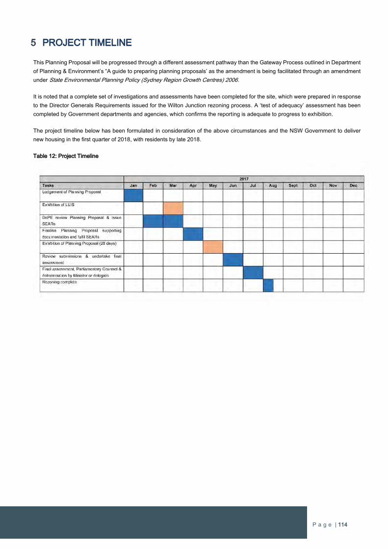
P a g e | 114
5 PROJECT TIMELINE
This Planning Proposal will be progressed through a different assessment pathway than the Gateway Process outlined in Department
of Planning & Environment’s “A guide to preparing planning proposals’ as the amendment is being facilitated through an amendment
under State Environmental Planning Policy (Sydney Region Growth Centres) 2006.
It is noted that a complete set of investigations and assessments have been completed for the site, which were prepared in response
to the Director Generals Requirements issued for the Wilton Junction rezoning process. A ‘test of adequacy’ assessment has been
completed by Government departments and agencies, which confirms the reporting is adequate to progress to exhibition.
The project timeline below has been formulated in consideration of the above circumstances and the NSW Government to deliver
new housing in the first quarter of 2018, with residents by late 2018.
Table 12: Project Timeline
P a g e | 115
6 CONCLUSION
The purpose of this planning proposal is to rezone the entire Wilton West landholding by amending Wollondilly Local Environmental
Plan 2011 to enable urban and residential development.
The rezoning amendment is to be facilitated by an amendment under State Environmental Planning Policy (Sydney Region Growth
Centres) 2006. The proposal will make the rezoning to Wollondilly LEP 2011 through a ‘24 hour SEPP’. This is the most appropriate
method to effect the intended outcome as outlined to meet the timeframes for housing delivery as set out by the NSW Government.
The Planning Proposal is consistent with the NSW Government’s strategic planning framework for urban growth in South West
Sydney, in particular the early planning undertaken for the Draft South West District Plan and Greater Macarthur Investigation Area.
The site also falls within an area identified for growth in ‘A plan for Growing Sydney’, which is the Government’s Metropolitan growth
strategy for Greater Sydney.
The proponent is committed to ensuring new residents have local job opportunities and local services early in the development. This
is demonstrated by the inclusion of a site-specific Employment Strategy to guide the early provision of new jobs and services.
The Planning Proposal will:
enable over 5,400 new homes and will create local businesses and jobs for local residents.
Early delivery of employment through construction and supporting businesses such as training.
A new kindergarten to Year 12 school in Wilton West in the first stages of development.
Creation of a Lakeside Activity Hub providing a diverse range of services and activities for local residents.
Health and supporting industries for the ageing population.
A diverse range of housing options to ensure all types of families and households can choose to live in Wilton West.
Land for large-format business to provide greater diversity in business and employment opportunities.
State and local infrastructure to support the future population, including the provision of extensive road upgrades, new public
transport facilitates, new education and recreational facilities, and conservation of environmentally significant land.
The following amendments to the Wollondilly LEP 2011 will be required:
Introduction of the additional zones – R1 General Residential and B5 Business Development
Amendments to text included in LEP
Amendments to LEP maps (land Use Zoning, Minimum Lot Size, etc.)
Introduction of additional maps
The proposal will result in numerous positive outcomes for the community and the wider Wollondilly LGA and enable the delivery of
new urban land within the future Wilton New Town planned by the NSW Government.

APPENDIX 1
“Wilton Lakeside Precinct: Employment Strategy and
Economic Masterplan” dated December 2016
by MacroPlan Dimasi

Wilton West Precinct
Employment Strategy and EconomicMasterplan
December 2016

© Macroplan Holdings Pty Ltd All Rights Reserved. No part of this document maybe reproduced, transmitted, stored in a retrieval system, or translated into anylanguage in any form by any means without the written permission of MacroPlanHoldings Pty Ltd. All Rights Reserved. All methods, processes, commercial proposalsand other contents described in this document are the confidential intellectualproperty of MacroPlan Holdings Pty Ltd and may not be used or disclosed to anyparty without the written permission of MacroPlan Holdings Pty Ltd.
Quality Assurance
Report Stage Author Date Review Date
Draft Report
Brian
Haratsis
September
2016 Gary Prattley
September
2016
Final Report
Brian
Haratsis
January
2016 Gary Prattley January 2016
Prepared for: Bradcorp Holdings Pty Ltd
MacroPlan Dimasi staff responsible for this report:
Brian Haratsis & Gary Prattley

This page has been intentionally left blank
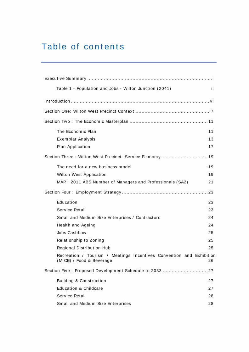
Table of contents
Executive Summary ...................................................................................i
Table 1 - Population and Jobs - Wilton Junction (2041) ii
Introduction............................................................................................vi
Section One: Wilton West Precinct Context ..................................................7
Section Two : The Economic Masterplan ....................................................11
The Economic Plan 11
Exemplar Analysis 13
Plan Application 17
Section Three : Wilton West Precinct: Service Economy...............................19
The need for a new business model 19
Wilton West Application 19
MAP : 2011 ABS Number of Managers and Professionals (SA2) 21
Section Four : Employment Strategy.........................................................23
Education 23
Service Retail 23
Small and Medium Size Enterprises / Contractors 24
Health and Ageing 24
Jobs Cashflow 25
Relationship to Zoning 25
Regional Distribution Hub 25
Recreation / Tourism / Meetings Incentives Convention and Exhibition(MICE) / Food & Beverage 26
Section Five : Proposed Development Schedule to 2033 ..............................27
Building & Construction 27
Education & Childcare 27
Service Retail 28
Small and Medium Size Enterprises 28
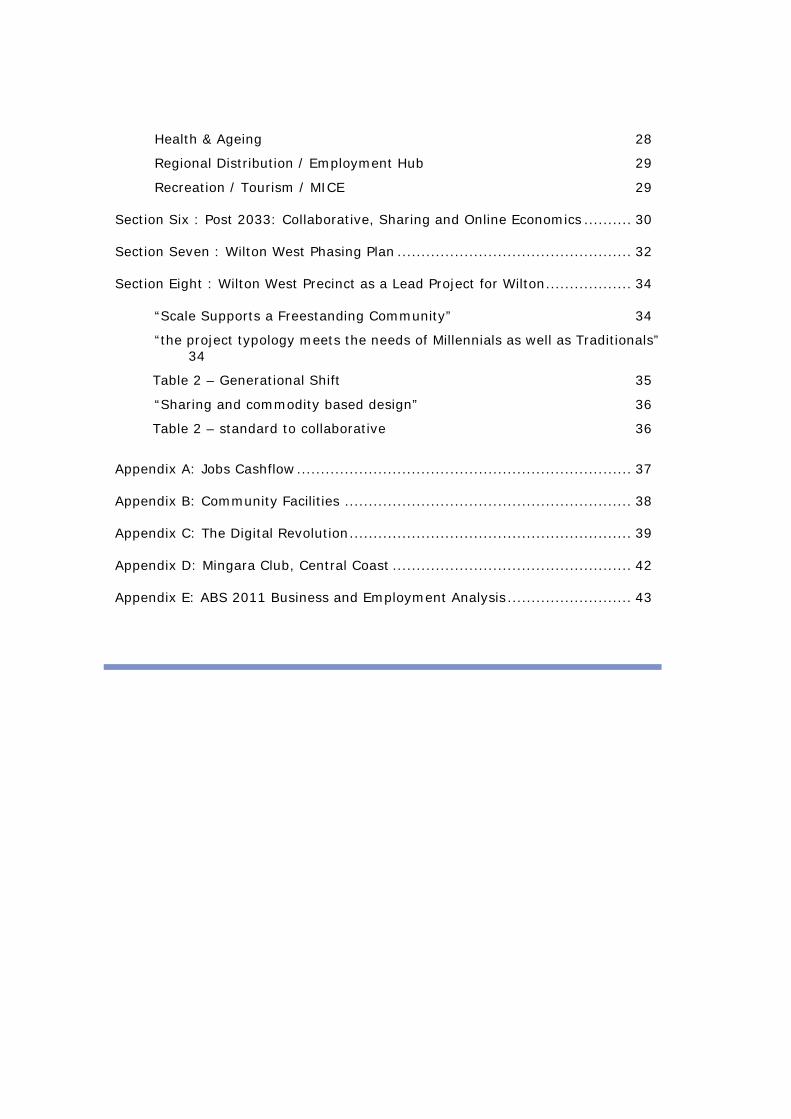
Health & Ageing 28
Regional Distribution / Employment Hub 29
Recreation / Tourism / MICE 29
Section Six : Post 2033: Collaborative, Sharing and Online Economics .......... 30
Section Seven : Wilton West Phasing Plan ................................................. 32
Section Eight : Wilton West Precinct as a Lead Project for Wilton.................. 34
“Scale Supports a Freestanding Community” 34
“the project typology meets the needs of Millennials as well as Traditionals”34
Table 2 – Generational Shift 35
“Sharing and commodity based design” 36
Table 2 – standard to collaborative 36
Appendix A: Jobs Cashflow...................................................................... 37
Appendix B: Community Facilities ............................................................ 38
Appendix C: The Digital Revolution........................................................... 39
Appendix D: Mingara Club, Central Coast .................................................. 42
Appendix E: ABS 2011 Business and Employment Analysis.......................... 43
Wilton West Precinct – Employment Strategy andEconomic Masterplan i
Executive Summary
Bradcorp has been developing a consistent vision for Wilton Junction for over 15 years,
following the initial impetus of the Macarthur Three Cities policy of the 1970’s. A key driver has
been to develop a new generation version of the ‘Garden City’ concept, an integrated and
largely self-contained town that could deliver a more diverse range of housing and employment
choice for South West Sydney. The intention is to provide options for the growing level of
professional employment in health, education and innovative industries. This was inspired by
the difficulties faced (in retention of professional staff) in the Campbelltown / Macarthur Health
precinct, and the need to lift the professional education level profile of the area.
Extensive work and analysis has been undertaken over the last five years in terms of future
demographic and employment profiles of the Wilton Priority Growth area, which has resulted
in a growth centre masterplan / conceptual strategy for a major town centre and associated
village / business / employment precincts.
Wilton West has always been envisaged as a premium location to attract a range of higher order
employment, social and cultural uses with a major K-12 private college already committed, i.e.
separate and distinct from the other planned retail/employment hubs that are expected to
service the needs of a 30,000-strong new town.
The potential to create alternative access to the Hume Highway to service the existing Bingara
Gorge development and the early stages of Wilton West provide opportunities to develop early
employment activation in anticipation of, and in support of, the future major town centre.
The intersection of national economic policies, the NSW Government’s economic development
strategies, Wollondilly Council’s commitments to economic and employment growth and the
emerging business and employment growth drivers (leading to a shift from monocentric to
polycentric city structures) provides a real opportunity to demonstrate at this location, how new
employment creation can be fostered. This would be a first for Sydney and a major economic
stimulus for the South West Growth Corridor.

Wilton West Precinct – Employment Strategy andEconomic Masterplan
ii
We know that more than 80% of the economic gross value add now derived from the services
sector and that about 80% of employment is in the service sector, which is increasing. The
combination of this with new technologies is creating opportunity for new urban structures
that harness the new service industries and their products.
This report explores how growth and innovation in services can be spatially accommodated
and how these spatial relationships might be re-invented to morph from commodity trading
relationships (e.g. retailing) to collaborative, innovative, sharing and supportive economies.
Early work that guided the planning for new housing and employment opportunities at
Wilton Junction identified the potential to create a new township of 11-13,000 new homes
and approximately 11,000 jobs. A masterplan has been prepared, earmarking a series of
residential neighbourhoods around green spaces, supported by a town centre of some
25,000m2, with associated business/industrial offerings and in close proximity to the Hume
Highway and Picton Road.
From an employment perspective, early planning anticipates the following housing and
employment outcomes:
Table 1 - Population and Jobs - Wilton Junction (2041)
CountTotal Residents 34,955
Employed Residents 12,000 – 13,200
Jobs in Wilton Junction 10,440 – 11,770
Employed residents working in Wilton Junction 8,400 – 9,240
- Work from home and not fixed 1,566 – 1,766
- Work in designated employment lands 6,834 – 7,474
Source: MacroPlan
More detailed analysis for the Wilton West Precinct provides opportunity to reconsider these
estimates and to plan for specific employment growth in more detail.
Executive summary
Wilton West Precinct – Employment Strategy iii
This process allows for a deeper consideration of current and emerging economic factors and
their implications for a ‘suburban’ new town format.
These factors include:
The emergence of Australia’s service sector;
A new level of understanding as to the employment potential from start-up
enterprises; and
An enhanced appreciation of the spatial and policy tools to tap into this potential
Spatial relationships at Wilton can accommodate exciting new lifestyles and start-up
businesses. The focus of non-CBD activity should be education, collaboration and sharing as a
basis for innovation and creativity. Accordingly, retailing should not be the future focal point.
Collaborative spaces, lifelong education, business incubation and lifestyle spaces (to promote
recreation and health) should dominate with ‘enabling’ spaces and uses (retail, active /
traditional transport hubs, distribution / warehouse space) in support locations which activate
the non-commodity spaces.
The Wilton West Precinct will provide a neighbourhood centre of 4-6000 sqm convenience
retail. The timing of the retail facilities in the lakeside precinct lifecycle will mean there will be
no impacts on the evolution of the district town centre (this is consistent with the delivery
models for most of the award winning large scale projects nationally).
The district town centre will not occur for at least 10 years and it will support the non-retail
uses over time, but we note its early stages will be primarily a retail oriented centre. Allowing
this centre to flourish for retail early on will ensure its primacy over the longer time.
Wilton West Precinct is forecast to deliver by 2033 job opportunities for 2,351 jobs. This is due
to the early mover approach focus on growth industries and recognising the role Wilton can
play in the regional and sub regional economies.
Wilton West Precinct will focus on a project lifecycle employment strategy which initially
utilises the construction industry to achieve to self-containment. As the project progresses
Wilton West Precinct – Employment Strategy andEconomic Masterplan
iv
and develops the health, education, recreation, retail and transport (and emergency services)
industries it will develop into a diversified economy based on the services sector.
The economic plan is based on the attraction of:
Small to medium size enterprises (SME’s)
Foundation building contracting businesses
Foundation health businesses and education services.
Analysis of local businesses indicates the extent to which small businesses dominate these
types of sectors in Wollondilly and Campbelltown (80-90% of businesses less than 5 people).
Further detailed analysis across Australia case studies demonstrates that:
Australia has a very high proportion of start-up businesses, and
Start-up business in Australia account for around 23% of new businesses but
around 50% of new employment
At 5,400 lots the Wilton West has the ideal scale to build a freestanding fully serviced
community. With a capacity population of 16,200 persons this precinct will support:
Full employment containment at one job per household
A full suite of educational opportunities (3 x childcare centres, 2 x primary
school, 1 x secondary school)
A full suite of weekly shopping opportunities
Comprehensive community facilities; and
High quality and accessible passive and active open space
Executive summary
Wilton West Precinct – Employment Strategy v
In 2017, the number of Millennials (persons born after 1980) will be greater than Traditionals
(born before 1980).
The needs and demands of Millennials are significantly different to Traditionals. These
differences include not only lifestyle choices but attributes to, and requirements for, emphasis
on health, wellbeing, technology and employment. This can be seen in terms a greater
emphasis on early childhood development, health and recreation facilities, reliance on
technology and a much greater emphasis on start-up businesses.
Millennials (born after 1980) have different lifestyles defined by the intersection of emotional
space, cyberspace and the physical world. Millennials are creating demand for new lifestyles,
spaces and places to live.
Wilton West precinct will also generate demand from Traditionals (in addition to Millennials),
due to the high levels of amenity, level of affordability, range of health care services, the early
opportunity to ‘cash out’ from an existing dwelling and continue to work. The provision of a
range of retirement living options will mean that the fundamental principle of a balanced
demographic community will be achieved on the project as it is developed.
The Wilton Priority Growth Area Master Plan provides a perfect framework for a collaborative
network driven growth area. The Lakeside activity hubs provides a desirable setting for the
translation and delivery of such an employment model.
Wilton West Precinct – Employment Strategy andEconomic Masterplan
vi
Introduction
MacroPlan has been commissioned to prepare an “Employment Strategy” and “Economic
Masterplan” for the Wilton West Precinct Planning Proposal. This report is an additional
research document, from the early planning material for Wilton-Junction, which has a
focussed role on describing the key strategic economic principles which are driving the design
response.
Essentially, this research drives the opportunity for Wilton West Precinct to leverage from the
implications of the economic factors driving a new suburban format, and rethinking how and
where we can accommodate growth and innovation in a masterplan due to:
The emergence of the services sector
Employment potential from start ups
Relationships between lifestyle and business
The interplay between these variables and others will have a strong influence on the future
development pattern. In summary, the sections of the report that address these outputs are:
Section One provides the necessary background and economic context
Section Two provides the economic plan which has been derived from case study
analysis and local demand considerations.
Section Three is an analysis of the service sector and key trends as they relate to the
Wilton West Precinct
Section Four is the employment strategy which drives the design outcomes
Section Five and Section Six is a detailed description of the development schedule pre
and post 2033
Section Seven provides a phasing plan which drives the staging of the masterplan
Section Eight reviews the critical elements that support lakeside as a lead project for
Wilton
Wilton West Precinct – Employment Strategy andEconomic Masterplan 7
Section One: Wilton West Precinct Context
This report updates MacroPlan’s employment forecast report prepared to inform the
early planning for Wilton-Junction (Employment Projections & Land Need, July 2014) and
builds upon the earlier Economic Development & Employment Strategy (October, 2013).
These previous reports outlined the market-based employment land needs to adequately
cater for the requirements of a 30,000-strong new township. They projected:
A population base of 34,955 persons by 2041
Between 10,440-11,770 jobs at Wilton
A likely three-phase growth in employment, involving:
o Population Induced Employment - comprising early retail and community-
based development to service population growth;
o Household Service and Transport-related Industry – those industries which
service households or which can benefit from improved transport (road)
infrastructure and the possibility of passing trade; and
o Operators that benefit from Business-to-Business Trade – industries that
service other businesses (business-to-business) are likely to evolve following
the second phase of development.
The context of the initial reports has not altered however we note that the inclusion of the
Greater Macarthur area as a future residential area:
Strengthens the long term economic opportunity for the regional centre
Creates demand for regional and sub-regional services
Accentuates the strength and opportunity of Wilton as:
Wilton West Precinct – Employment Strategy andEconomic Masterplan
8
o A nodal location and
o A regional and sub-regional distribution hub. This includes construction,
emergency and human services
The Wilton West Precinct can accommodate a range of employment rich land uses and
activities. In preparing our report, we assessed three strategic elements which is currently
driving the economic context for Wilton West Precinct:
Theme One: Economic
Sydney’s economic growth is healthy, with the continued investment by state
government on the infrastructure program which is expected to continue, this will
drive the economy once the pace of the dwelling construction (apartment)
moderates
A shortage of housing still exists in NSW, even with the increased production of
residential construction. Strong population growth and low interest rates are
continuing to support demand. The continued camping out for new lots in indicative
for the need for a more competitive range of development fronts and land supply.
The rise in house prices is providing continued support to consumer spending.
Services tied to consumer spending are benefiting from this economic environment –
health, professional, retail, food and accommodation.
A lower Australian dollar and positive conditions in the retail sector and labour
market provide an encouraging outlook for continued investment.
Theme Two: Employment
Sydney and south west Sydney have continued to average annual jobs growth close
to 1.5% over the past 5 years
Jobs and household growth will continue to be supported from the broader
construction cycle
Population growth across the South West will continue to be a major facilitator for
employment growth
Wilton West Precinct – Employment Strategy 9
Major Infrastructure investment (road, rail, airport) and expansion in transport and
the logistics industry will be a major factor of growth
As the local economy matures health, education, professional services will
experience strong demand
The delivery of the whole corridor will continue to drive industry expansion and
supply chain growth across the region
Remote and mobile workers will continue to be attracted given the geographic
access with increased infrastructure delivery (WSEA, Badgerys Creek, Illawarra etc)
Theme Three: Housing
Residential construction has been the catalyst for the strong population growth
The shifts in the residential property market, as well as jobs growth and economic
stimulus supports the rise in demand for new housing
Regional population growth is being driven by diversity in the demographic sub
markets – this includes first home buyers (25-39) to persons aged 65+
Primary shifts towards smaller lot housing within newer residential estates in the
south west is attracting primary shifts in demand
Many older age groups and mature families can downsize or cash out due to the
recent growth in the value of residential property, and this is driving a demand for a
wider range of housing options such as over 55 lifestyle villages or resort parks
In assessing the overall demand context for Wilton West Precinct, previous MacroPlan
economic studies have addressed the consumer segments. The consumer or target segments
that will activate and support the proposed candidate uses will include:
Permanent residents
Local workforce
Local and visiting aquatic and recreational users
Day visitors from other locations
Demographic analysis of the local and regional population, identifies key trends in the
consumer groups as being:
Wilton West Precinct – Employment Strategy andEconomic Masterplan
10
0-19 and 24-49 year old age groups
Additional representation from senior age groups, higher than other new estate
locations across Sydney (due to current population characteristics and housing
product)
Couple families with children and retiree households (couple families without
children and lone person households)
Residents with ‘lifestyles’ which complement the Wilton West Precinct and proposed
land uses
Local workforce across population drive and external market industries

Wilton West Precinct – Employment Strategy 11
Section Two : The Economic Masterplan
The Economic Plan
In developing the Wilton West Precinct employment strategy, an economic plan has been
developed to provide guidance to the design and preparation of the master plan. The plan
has been a response to the emerging economic factors driving the future of Australia and
Greater Sydney.
We support the current planning policy focus that cities of the future may not be bound by
the requirements for centralised areas or businesses clustering the same way as today,
primarily due to the greater access and ease of movement across Metropolitan Sydney.
A new set of principles will be shaped by the spatial patterns of commerce, new technology
driving city fringe development and environmental living being attractive for residents.
The design of the economic plan is a response to leverage from the implications of the new
suburban format and rethink how / where we accommodate growth and innovation. Key
economic shifts we are observing include:
The emergence of the services sector
Employment potential and growth from start-up enterprises
New relationships between lifestyle and business
The interplay between these variables and others will have a strong influence on the future
development pattern, which has been addressed in the analysis.
Essentially, the economic plan will deliver:
an integrated project approach and largely a self-contained town that can deliver a
diverse range of housing and employment choices
a progressive economic strategy to maximise the early establishment of employment
and foster its growth through a collaborative network driven growth area
Wilton West Precinct – Employment Strategy andEconomic Masterplan
12
encourage a collaborative, innovative, sharing and supporting environment through
embracing the implications from technology on the new urban structure
‘enabling spaces’ which will be home to collaborative working, lifelong education,
business incubation and promote recreation and social interaction
Traditional industries (active / traditional transport hubs, distribution / warehouse
spaces) which will be in supportive locations which activate the non-commodity
spaces
Provide new opportunities to harness industry that is core for those people and
businesses involved in health, education and innovation sectors
diverse housing delivery approach and attraction of different demographics,
residents who will be involved right through from higher order employment, to social
and cultural activities
The economic plan driving the employment outcomes is:
Meeting existing gaps based on demand e.g. already committed to a K-12 Anglican
College
Trapping construction multipliers locally
Leveraging the fastest growing economic sectors i.e. health and education
Attracting small to medium side (SME’s) enterprises and contractors
Leveraging local amenity (i.e the lake) to accommodate a wide range of recreational
cases (e.g. club, gymnasium) and regional meetings and conferences
Provision of service retail to service local needs, recognising the regional retail
centre will not be feasible for around 10 years
Leveraging ingress and egress to the freeway to accommodate a range of regional
and sub-regional uses including emergency services, transport services, home care
services etc.
Complement the proposed future Regional Centre and focuses on:
Wilton West Precinct – Employment Strategy 13
o A range of uses which vertically integrate by sectors e.g. health
In terms of health the focus is on ageing including retirement, aged care, palliative care and
allied health utilising the high end demand for health services to grow a deeper health sector.
A range of uses with synergies e.g. (combining health with education) will provide local
training opportunities including the construction industry with training opportunities and
deepening of the longer term plans for localised VET courses. This will be achieved through
the provision of dedicated training floor space.
The focus of building a real local economy will range from:
The provision of collaborative workspaces
Creating a range of lot sizes
Accommodating contractors required for building and construction
The district centre has a focus of providing more land intensive uses, ensuring
complementary place making.
Exemplar Analysis
In essence the Wilton West Precinct will complement the district Centre. Through our
analysis, this approach has been successfully used many times. For example a National
review of projects identifies the following:
The Lakeside in Pakenham (VIC) complements the Berwick and Pakenham town
centres.
o The Lakeside is a community focus that encourages residents to get involved
with events such as walking groups, community BBQs and special interest
groups.
o The Lakeside Village offers a mix of retail from daily convenience to dining.
Wilton West Precinct – Employment Strategy andEconomic Masterplan
14
o 36 hectares of green and natural spaces for outdoor activities, a 6 lane 400m
rowing course in the centre of the superb 6.5-hectare lake
Caroline Springs in Melbourne grew the Lakeside (village) precinct prior to the
Caroline Springs Town Centre:
o 22klm west of Melbourne, Caroline Springs is developed over 800ha which
comprises 18 villages, each with their own park and a resident population of
19,000 persons – expected to reach a total population of 23,000 upon
completion and support a local workforce of 6,500 jobs.
o A 7.8ha Lake Caroline adjoins the town centre, which features supermarkets,
cafes, restaurants, pharmacy etc. Also located is 2 hotels, 3 colleges, library,
police station, medical centre and a leisure centre.
o A second lake is located at the Village Precinct, surrounded mostly by
residential with a medical centre, catholic school, college and small
community centre, convenience store and few cafes and restaurants.
o A small home based centre was established with Melton Council, offering
serviced offices and boardroom for leases to local businesses below market
rates
Ellenbrook (Perth) started with a lakeside centre and a second neighbourhood
centre more than 10 years before the town centre was constructed.
o The Woodlake precinct features a smaller set of shops designed for daily
convenience. The lake is mostly surrounded by residential and is adjacent to
a primary school, community centre and shopping centre.
o The development of the Woodlake precinct was a first stage of a small
neighbourhood precinct and a jointly funded community centre with the first
“schools in houses” project. At the commencement of development a
medical suite, chemist and project office / display centre was added.
Wilton West Precinct – Employment Strategy 15
o Recreational elements also include playground, basketball court and walking
tracks
Googong (Canberra) started with a neighbourhood activity hub followed 4-5 years
later with a neighbourhood centre. A town centre is planned for construction
within the next 2-3 years.
o 16klm south east of Canberra, the development will house 5,550 homes, an
expected population of 16,000 persons and an estimated 2,500 operational
jobs at completion.
o Each of the neighbourhoods will feature a village or neighbourhood centre,
ranging in size from a small strip of shops to minor retail centres.
o The upfront activity hub included a multi-purpose community centre, 25m
pool, coffee shop, gym, restaurant and small shop and sales office. Given the
sites isolation this played a major part in increasing the attractiveness of the
state and doubling the sales rate in the first year. The retail component was
supported by the initial residents and construction workforce creating a
vibrant centre from the start.
Brighton Butler town centre (again adjacent to the Lake / open space) was
constructed more than 10 years before the sub-regional centre (30,000 sqm)
some 3km to the north
The Department of Planning (NSW) itself held the Rouse Hill Town Centre site for
some 25 years until the surrounding suburbs achieved the entitled mass to
support the centre. In the interim, local neighbour centres such as Stanhope
Gardens developed to serve the community.
An assessment of each of these town centres and regional / sub-regional centres has
different relationships based on:
Catchment size and population driven jobs
Wilton West Precinct – Employment Strategy andEconomic Masterplan
16
Spatial relationships between the centres
Locational factors e.g. access to freeways / exposure
Regional context for long term business growth (e.g. in our case Greater
Macarthur and the Wilton regional catchment)
Existing and future regional and sub-regional supply and demand gaps
Potential to localise economic multipliers e.g. Wilton’s distance from other
growth centres
A number of success factors of the design elements of projects has been identified (which
have supported the economic performance), which will relevant to the Wilton West Precinct:
Natural setting / beauty / view : aesthetics and building design that
complements the setting
Accessibility / proximity : not only proximity to surrounding permanent
residents, but access to the regional population through regional and local road
connection
Point of difference / operations: commercial operations in a destinational
precinct such as Wilton West Precinct is a key point of difference. Multiple
spaces, point of difference in offering and the commercial operation / plan will
be important.
Wilton West Precinct – Employment Strategy 17
Plan Application
In applying the findings from the research, we make the following observations:
Wilton West Precinct can, with the right economic plan, capture a high
proportion of economic multipliers, particularly in relation to construction. It is
expected that by the mid to late 2020’s Wilton West Precinct will be the primary
construction and construction services hub for the entire southern portion of
Greater Macarthur.
Given the construction and development timeframe, Wilton West Precinct has
the opportunity to tap into the growing collaborative and sharing economies
driven by the online economy and potentially post 2025 including Automated
Vehicles.
This suggests that from an economic perspective Wilton West Precinct takes on
attributes of a ‘post main street’ planning. That is to say that Wilton West
Precinct could become an exemplar project integrating key elements of the new
services economy and focusing on the fast growing SME sector.
The landowner/developer is actively seeking partners to establish new
businesses and new facilities (i.e Wollondilly Anglican School)
Key parameters of the economic plan which compliment broader objectives include:
Increasing the retention of lot and dwelling construction economic multipliers over
time. Specifically increasing for 25% job retention in 2018 to 50% by 2023 by:
o Requiring builders to open local offices
o Creating early supply base and supply opportunities for builders
o Requiring builders to train apprentices locally
o Initiating local landscape supply
Wilton West Precinct – Employment Strategy andEconomic Masterplan
18
o Initiating local builder waste collection
o Creating co-ordinated display home opportunities utilising local sales teams
o Creating local supply chains for solar panels, water tanks etc
o Initiating web based listings and business opportunities for existing local
business
This strategy will require provision of 6-10 ha of service industry land to accommodate these
uses.
Wilton West Precinct – Employment Strategy 19
Section Three : Wilton West Precinct: ServiceEconomy
The need for a new business model
The potential interaction between the future services sector and technology is likely to be a
key driver of future city structures. This outcome is likely because:
More than 80% of economic gross value added is derived from the services sector and
this is increasing.
Almost 80% of employment is in the services sector and this is increasing.
More than 65% of household consumption is services and this is increasing.
The services sector is increasingly driven by big data and big analytics to create and deliver new
services. The combination of smart phone technologies, city-wide embedded devices (sensors)
and geographic information systems (GIS) are pervading everyday urban experiences and
creating new urban structures, which in turn are creating new services industries and products.
Wilton West Application
Wilton West Precinct will focus on a project lifecycle employment strategy which initially
utilises the construction industry to achieve self-containment but as the project progresses
and develops the health, education, recreation, retail and transport (and emergency services)
industries will develop into a diversified economy based on the services sector.
The economic plan is based on the attraction of:
Small to medium size enterprises (SME’s)
Foundation building contracting businesses
Foundation health businesses and foundation education services.
Attached (Appendix) is an analysis of businesses and employment sectors which indicates the
extent to which small business dominates in Wollondilly and Campbelltown (80-90% of
Wilton West Precinct – Employment Strategy andEconomic Masterplan
20
businesses less than 5 people). Further detailed analysis undertaken of case studies across
Australia demonstrates that:
Australia has a very high proportion of start-up businesses, and
Start-up business in Australia account for around 23% of new businesses but
around 50% of new employment
This strategic positioning is actively supported by:
The inclusion of a large scale collaborative workspace (incubator)
The design and development of three activity nodes (health, business and retail)
The integration of the sharing economy through shared car parking initially and
The integration of the online economy through the inclusion of urban warehouse
and freight facilities to overcome the last ‘mile’ delivery problem.
The service economy in Australia is growing strongly. For example in the 2016 July quarter
75,000 new jobs were added into professional and technical services sectors. The health
sector however, with 13% of total jobs (1.52 million) remains the largest sector, which is a
focal point for the lakeside Precinct.

Wilton West Precinct – Employment Strategy 21
MAP : 2011 ABS Number of Managers and Professionals (SA2)
Source: MacroPlan 2016, ABS 2011
The development will create a high quality residential community in South West Sydney,
which can provide further alternative locations for professionals and managers to reside
outside of the traditional locations of inner Sydney, north / west and northern suburbs (see
map on the previous page). These decisions will not just be driven by residential amenity, but
also job opportunities.

Wilton West Precinct – Employment Strategy andEconomic Masterplan
22
We understand that the region will need time to develop. As such, overtime the professional
and household services sector will counterbalance the construction sector in the Lakeside
precinct to create a jobs structure typical to the Sydney metropolitan area.
To understand the business structure and employment trends, analysis was undertaken of
the available ABS data to understand how the region is transitioning. The detailed outputs
are located in the Appendix, however key observations of the structural changes in the local
employment market between 2011 and 2015 are as follows:
Camden:
o Growth in the number of businesses construction (13%) and health care
(27%) industries
o Significant growth in the number of persons employed in construction (22%),
education (32%) and health (33%)
Campbelltown
o Decline in the number of businesses in construction (2%) and education /
training (12%)
o Growth in the health care and social assistance businesses (26%)
Wollondilly
o Decline in the number of businesses in education / training (20%)
o Increases in businesses operating in health care and social assistance (21%)
and construction (5%)
o Increase in those employed in all these industries – construction (15%),
health care and social assistance (17%) and education / training (6%)
Wilton West Precinct – Employment Strategy 23
Section Four : Employment Strategy
The economic plan for each of the land uses will be driven by a proactive strategy to
initiate development. The employment uses to be delivered are specifically:
Education
Initiating the project through a strong relationship with education including:
o Delivery of K-12 Anglican college by 2020
o Three child care centres (and early childhood services)
o A second private primary school
o One public primary school
o The early (2020) development of a training facility for building and
construction apprentices
o A library (1500sqm) by 2023
o Community centre (650sqm) by 2025
o Child health facility (150sqm) by 2025
Service Retail
The service retail space will be adaptive to addressing the upfront development of
convenience retail and two shop fronts / sales office;
Then the construction of a neighbourhood retail centre (first stage) by 2023
Wilton West Precinct – Employment Strategy andEconomic Masterplan
24
Small and Medium Size Enterprises / Contractors
The strategy is to develop an office incubator by 2023 recognising the importance
of the online and collaborative economies. The objective is to make Wilton the
epicentre of construction and construction support employment for the next 30
years of the development of Greater Macarthur.
The incubator is to include accounting, information technology, human resources,
legal and marketing support to firmly root the construction industry in Wilton.
Health and Ageing
The precinct will deliver a critical mass of health offering which caters for the range
of residents from young families with children to the ageing population who is
downsizing or requires care and services.
The corridor already has supply of retirement and aged care facilities albeit on a
relatively small and dispersed scale. The land use plan is as follows:
o Develop a concentration of retirement and aged care facilities recognising
supply in the remainder of the corridor based on our analysis:
A minimum of 100 retirement living units (ILU’s) could be delivered
by 2024. Depending on alternative supply this would be up to 200
units.
A minimum of 80 Aged care beds could be delivered by 2025.
Depending on alternative supply this could be up to 120 beds.
A manufactured / lifestyle housing estate of up to 200 dwellings
could be viable by 2025
o Focusing on retirement and aged care provides a basis for:
Developing a regional homecare hub
Wilton West Precinct – Employment Strategy 25
Developing a regional base for allied health.
The allied health hub is proposed to be constructed in 2025 with the
first stage being 500 sqm and the second stage being an additional
500 sqm.
Jobs Cashflow
The following table (from Appendix A) demonstrates where the jobs will come from
and how they will be provided X time to deliver one job per household throughout
the development of the project.
Relationship to Zoning
The zonings proposed in the Planning Proposal, particularly the B4 and B5 zones,
have the capacity and are appropriate to enable this growth.
Regional Distribution Hub
The nodal location of the Wilton West Precinct is ideal to support the provision
of a range of distribution / employment hubs. This includes:
o Emergency services
o Freight and logistics
o Buses
o Human services (e.g. homecare)
o Employment uses
Wilton West Precinct – Employment Strategy andEconomic Masterplan
26
The concept is to provide 10 to 15 ha of land to accommodate these type of uses.
Recreation / Tourism / Meetings Incentives Convention andExhibition (MICE) / Food & Beverage
This strategy leverages on the amenity of the Lake, the need and opportunity for
a local meeting place. The club concept is based on the Mingara Club (see
Appendix) located the Central Coast and envisages a range of uses (food /
convenience etc) located adjacent. The Club would incorporate a major
gymnasium plus secondary convention and exhibition space. The first is
proposed to be built in 2023 and the second stage including accommodation
around 2027/8.
An 80 room accommodation facility would also have a strong commercial
relationship to the MICE / Club facilities and the health related uses across the
precinct.
Wilton West Precinct – Employment Strategy 27
Section Five : Proposed Development Schedule to2033
At 2033 based on the project delivery program, Wilton West Precinct is forecast to deliver
2,351 local jobs. This is due to the early mover advantage and a focus on growth industries
and recognising the role of Wilton can play in the regional and sub-regional economies.
Post 2026 it is anticipated that employment will be provided in much more diversified
economy and it is forecast that Lakeside will benefit from:
Increased demand from health and ageing
Increased demand for health and homecare
Increased demand for education
Increased opportunities for building and construction businesses
Increase of importance of the nodality of the Regional Centre as it begins to grow
The economic plan has considered the proposed development schedule at 2033 as follows:
Building & Construction
6 ha – 10 ha service industry land
Training facility
Business incubator
Education & Childcare
1 x private K-12 school (Committed)
3 x childcare centres
1 x public primary school
1 x private primary school
Wilton West Precinct – Employment Strategy andEconomic Masterplan
28
1 x public library
1 x child health facility
Service Retail
Convenience retail
1 x neighbourhood centre (4-6,000 sqm)
Associated business and service facilities
Freight / delivery
Market / agora
The timing of retail facilities later in the Lakeside precinct life-cycle will mean that there
will be no impacts on the evolution of the town centre. The town centre will support non-
retail uses over time, but in its early stages, it will be primarily a retail oriented centre.
Allowing this centre to flourish for retail early on will ensure its primacy over the longer
term.
The proposed retail and non-retail mix at the Lakeside precinct will have no impact on the
large format/bulky goods retail precinct.
Small and Medium Size Enterprises
Construction, marketing and management of an office incubator (500 sqm) in
2023 and expansion to 2,000 sqm around 2028.
Theme the incubator into non-construction enterprises and construction related
enterprises. This includes insurance, design, finance etc.
Health & Ageing
Construction of DMF based retirement independent living units (100 units by
2024) and additional 100 units by 2028)
Wilton West Precinct – Employment Strategy 29
Construction Aged care (80 beds by 2025 and 160 beds by 2030)
Allied health office type floor space construction of 500 sqm by 2025 and
additional 500 sqm by 2030
Consideration for construction of 200 units high quality manufactured Housing
Estate by 2027
Regional Distribution / Employment Hub
The proposal is to secure emergency services (five / ambulance / police),
transport services including bus depots) and freight and logistics and human
services (e.g. car dependent homecare) by 2025. It is envisaged that 10ha – 15 ha
would be required for those uses.
The regional bus hub will also provide a relationship to the park and ride facilities
Recreation / Tourism / MICE
The proposal is to construct a ‘Mingarra’ type Club (NSW Central Coast) including
major gymnasium plus second tier convention, meeting and exhibition space
together with 80 accommodation rooms plus food and beverage.
Construction of the first stage is proposed to begin in 2023 with completion to
capacity by 2030.
Wilton West Precinct – Employment Strategy andEconomic Masterplan
30
Section Six : Post 2033: Collaborative, Sharing andOnline Economics
In 2018 the Wilton West Precinct was planned with the future in mind. First there was a clear
idea that over the 30 year life of the project that technology should have a significant influence
on community building. Second this understanding translated into new approaches to
economic development (the proposed four phase approach), Urban design and project
management.
The development philosophy incorporated ‘smart’ city thinking including the use of technology
to achieve sustainability outcomes, safety outcomes and economic development outcomes
provided in an affordable housing and lifestyle context (see Appendix).
In 2033 Wilton West has completed its first stage of economic development based on the four
phases in the economic development plan. Wilton West has a modern and diversified economy
because it integrated the influences of the collaborative, sharing and online economy into its
community development and urban design frameworks. The second stage of community
development integrates the full impacts of the Internet of Things, Automated Vehicles and
Robotics and establishes Wilton Lakeside as the ‘Best of breed’ Sydney Suburbs.
Interconnectedness has not only occurred through the progressive influence of the internet of
things and disruptive technologies like Uber and eBay but also through:
The integration of health care services
The integration of childcare services with family lifecycles
Broad based utilisation of digital technology in the provision of community services
and community support
Localised utilisation of network technologies to support community building and
place making
Wilton West Precinct – Employment Strategy 31
The Wilton West Precinct planned for the evolving ecology of mobility by ensuring that:
Active transport would be a feature of the project
Car sharing would be aggressively accommodated
The right transport infrastructure was put in place to accommodate:
o Automated (driverless) vehicles
o Early introduction of remote car parking
o Early introduction of Automated (driverless) buses
Automated Vehicles and remote parking would be fully integrated with local and
regional trunk public transport systems
Urban design opportunities and principles have been developed to nurture the collaborative
sharing and online economies.
In stage 1 to 2033 this has resulted in three connected activity nodes. Post 2033 it is envisaged
that the fourth node will also be seamlessly connected.
Flexibility in activity node design will be essential to accommodate the growth potential which
could emerge from not only accommodating but actively supporting the growth of SME’s based
on sound economic foundations.

Wilton West Precinct – Employment Strategy andEconomic Masterplan
32
Section Seven : Wilton West Phasing Plan
Wilton West precinct will endure four phases in its economic plan and a jobs balance.
Phase 1: Construction Employment + Training
The project will be dominated by construction and construction related employment. Tomaximise jobs outcomes, activate contract and development management will be required tomaximise the localisation of job multipliers.
Phase 2: Foundation Service Sector Employment
This phase introduces:
Education (Primary & Secondary schools)
Training (VET / Construction and training facility)
Collaboration (small business incubator)
Recreation / place making (club with recreational facilities)
Retail (neighbourhood centre)
Phase 3 Growth
This phase introduces:
Allied health and significant retirement living options as a baseload for growing a
regionally significant allied health industry
Significant employment land
Emergency services
Regional transport + distribution (e.g. bus depot, homecare)
Regional freight and logistics
Expansion to the retail offer
Expansion to the business incubator
Introduction of community services employment
Wilton West Precinct – Employment Strategy 33
Phase 4 Maturity
This phase accommodates a wide range of centre based and non-centre based contractors andSME’s which can service the local and regional requirements and provides the basis for adiversified and resilient economy for the Wilton West Precinct. It positions greater Wilton togrow to a regional service centre level.
Wilton West Precinct – Employment Strategy andEconomic Masterplan
34
Section Eight : Wilton West Precinct as a LeadProject for Wilton
The Wilton West precinct will be the lead project for Wilton supporting a freestanding
community and having a wide appeal to the needs of the community.
The key project themes from this analysis are:
“Scale Supports a Freestanding Community”
At 5,400 lots the Wilton West Precinct has the ideal scale to build a freestanding fully serviced
community. With a capacity population of 16,200 persons this precinct will support:
Full employment containment at one job per household
A full suite of educational opportunities (3 x childcare centres, 2 x primary school,1 x secondary school)
A full suite of weekly shopping opportunities including a full line supermarket
Comprehensive community facilities
High quality and accessible passive and active open space
“the project typology meets the needs of Millennials as well asTraditionals”
In 2017 the number of Millennials (persons born after 1980) will be greater than Traditionals
(born before 1980).
The needs and demands of Millennials are significantly different to Traditionals. These
differences include not only lifestyle choices but attributes to, and requirements for, emphasis
on health, wellbeing, technology and employment. This can be seen in terms a greater
emphasis on early childhood development, health and recreation facilities, reliance on
technology and much greater emphasis on start-up businesses.
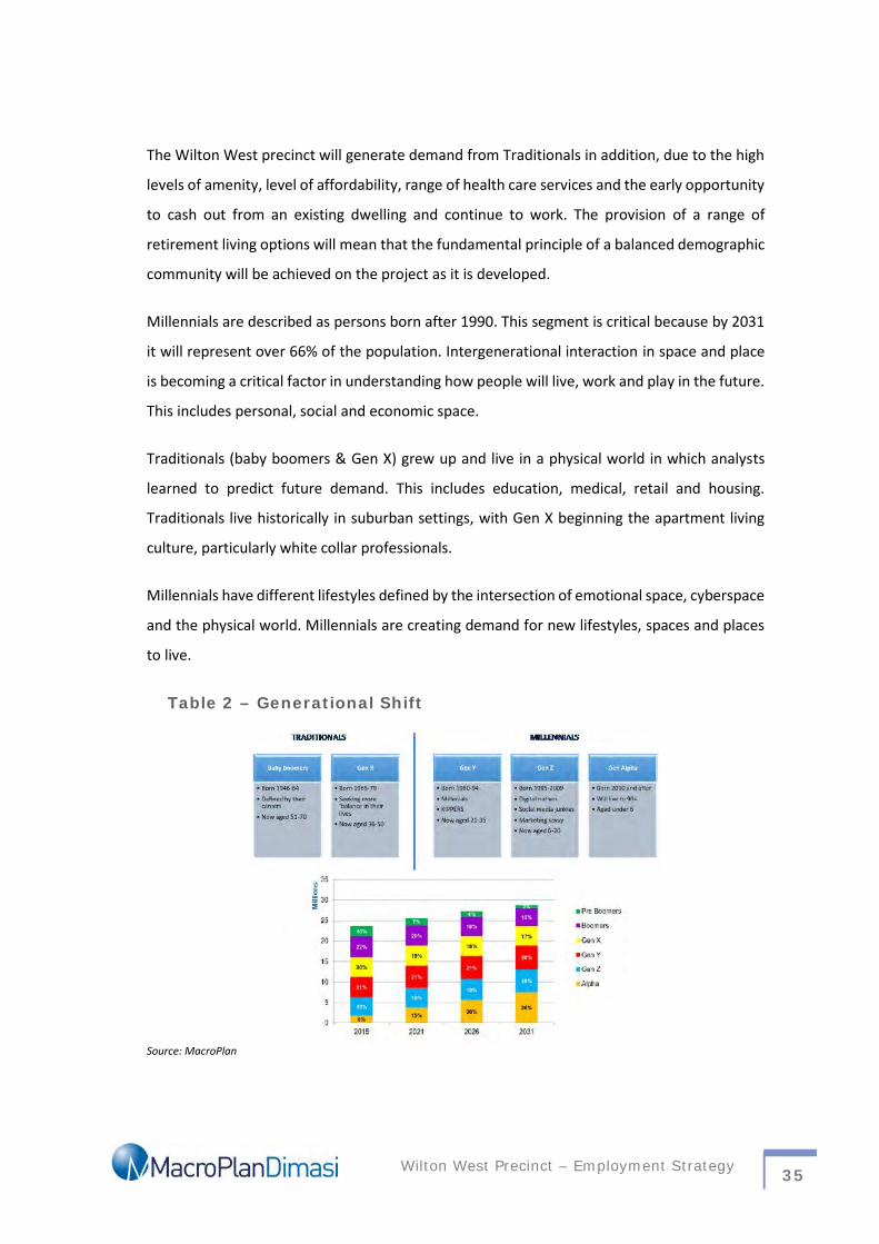
Wilton West Precinct – Employment Strategy 35
The Wilton West precinct will generate demand from Traditionals in addition, due to the high
levels of amenity, level of affordability, range of health care services and the early opportunity
to cash out from an existing dwelling and continue to work. The provision of a range of
retirement living options will mean that the fundamental principle of a balanced demographic
community will be achieved on the project as it is developed.
Millennials are described as persons born after 1990. This segment is critical because by 2031
it will represent over 66% of the population. Intergenerational interaction in space and place
is becoming a critical factor in understanding how people will live, work and play in the future.
This includes personal, social and economic space.
Traditionals (baby boomers & Gen X) grew up and live in a physical world in which analysts
learned to predict future demand. This includes education, medical, retail and housing.
Traditionals live historically in suburban settings, with Gen X beginning the apartment living
culture, particularly white collar professionals.
Millennials have different lifestyles defined by the intersection of emotional space, cyberspace
and the physical world. Millennials are creating demand for new lifestyles, spaces and places
to live.
Table 2 – Generational Shift
Source: MacroPlan
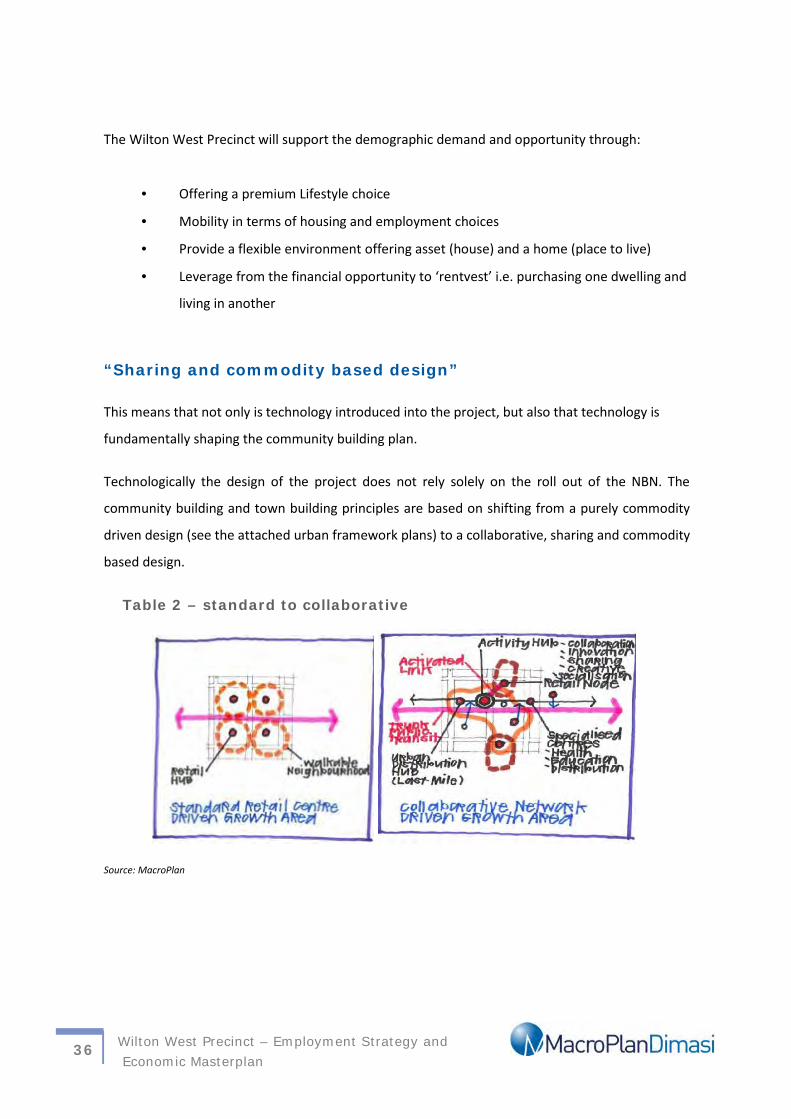
Wilton West Precinct – Employment Strategy andEconomic Masterplan
36
The Wilton West Precinct will support the demographic demand and opportunity through:
Offering a premium Lifestyle choice
Mobility in terms of housing and employment choices
Provide a flexible environment offering asset (house) and a home (place to live)
Leverage from the financial opportunity to ‘rentvest’ i.e. purchasing one dwelling and
living in another
“Sharing and commodity based design”
This means that not only is technology introduced into the project, but also that technology is
fundamentally shaping the community building plan.
Technologically the design of the project does not rely solely on the roll out of the NBN. The
community building and town building principles are based on shifting from a purely commodity
driven design (see the attached urban framework plans) to a collaborative, sharing and commodity
based design.
Table 2 – standard to collaborative
Source: MacroPlan
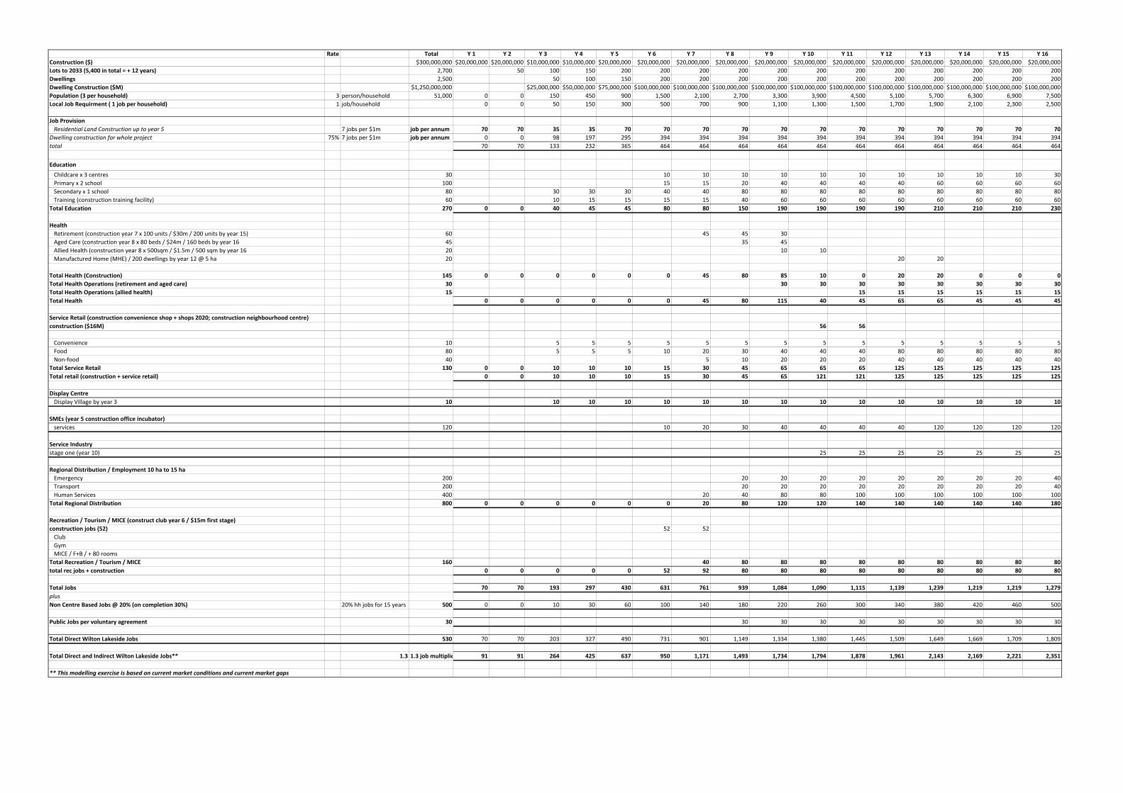
Rate Total Y 1 Y 2 Y 3 Y 4 Y 5 Y 6 Y 7 Y 8 Y 9 Y 10 Y 11 Y 12 Y 13 Y 14 Y 15 Y 16Construction ($) $300,000,000 $20,000,000 $20,000,000 $10,000,000 $10,000,000 $20,000,000 $20,000,000 $20,000,000 $20,000,000 $20,000,000 $20,000,000 $20,000,000 $20,000,000 $20,000,000 $20,000,000 $20,000,000 $20,000,000Lots to 2033 (5,400 in total = + 12 years) 2,700 50 100 150 200 200 200 200 200 200 200 200 200 200 200 200Dwellings 2,500 50 100 150 200 200 200 200 200 200 200 200 200 200 200Dwelling Construction ($M) $1,250,000,000 $25,000,000 $50,000,000 $75,000,000 $100,000,000 $100,000,000 $100,000,000 $100,000,000 $100,000,000 $100,000,000 $100,000,000 $100,000,000 $100,000,000 $100,000,000 $100,000,000Population (3 per household) 3 person/household 51,000 0 0 150 450 900 1,500 2,100 2,700 3,300 3,900 4,500 5,100 5,700 6,300 6,900 7,500Local Job Requirment ( 1 job per household) 1 job/household 0 0 50 150 300 500 700 900 1,100 1,300 1,500 1,700 1,900 2,100 2,300 2,500
Job ProvisionResidential Land Construction up to year 5 7 jobs per $1m job per annum 70 70 35 35 70 70 70 70 70 70 70 70 70 70 70 70
Dwelling construction for whole project 75% 7 jobs per $1m job per annum 0 0 98 197 295 394 394 394 394 394 394 394 394 394 394 394total 70 70 133 232 365 464 464 464 464 464 464 464 464 464 464 464
EducationChildcare x 3 centres 30 10 10 10 10 10 10 10 10 10 10 30Primary x 2 school 100 15 15 20 40 40 40 40 60 60 60 60Secondary x 1 school 80 30 30 30 40 40 80 80 80 80 80 80 80 80 80Training (construction training facility) 60 10 15 15 15 15 40 60 60 60 60 60 60 60 60
Total Education 270 0 0 40 45 45 80 80 150 190 190 190 190 210 210 210 230
HealthRetirement (construction year 7 x 100 units / $30m / 200 units by year 15) 60 45 45 30Aged Care (construction year 8 x 80 beds / $24m / 160 beds by year 16 45 35 45Allied Health (construction year 8 x 500sqm / $1.5m / 500 sqm by year 16 20 10 10Manufactured Home (MHE) / 200 dwellings by year 12 @ 5 ha 20 20 20
Total Health (Construction) 145 0 0 0 0 0 0 45 80 85 10 0 20 20 0 0 0Total Health Operations (retirement and aged care) 30 30 30 30 30 30 30 30 30Total Health Operations (allied health) 15 15 15 15 15 15 15Total Health 0 0 0 0 0 0 45 80 115 40 45 65 65 45 45 45
Service Retail (construction convenience shop + shops 2020; construction neighbourhood centre)construction ($16M) 56 56
Convenience 10 5 5 5 5 5 5 5 5 5 5 5 5 5 5Food 80 5 5 5 10 20 30 40 40 40 80 80 80 80 80Non-food 40 5 10 20 20 20 40 40 40 40 40
Total Service Retail 130 0 0 10 10 10 15 30 45 65 65 65 125 125 125 125 125Total retail (construction + service retail) 0 0 10 10 10 15 30 45 65 121 121 125 125 125 125 125
Display CentreDisplay Village by year 3 10 10 10 10 10 10 10 10 10 10 10 10 10 10 10
SMEs (year 5 construction office incubator)services 120 10 20 30 40 40 40 40 120 120 120 120
Service Industrystage one (year 10) 25 25 25 25 25 25 25
Regional Distribution / Employment 10 ha to 15 haEmergency 200 20 20 20 20 20 20 20 20 40Transport 200 20 20 20 20 20 20 20 20 40Human Services 400 20 40 80 80 100 100 100 100 100 100
Total Regional Distribution 800 0 0 0 0 0 0 20 80 120 120 140 140 140 140 140 180
Recreation / Tourism / MICE (construct club year 6 / $15m first stage)construction jobs (52) 52 52
ClubGymMICE / F+B / + 80 rooms
Total Recreation / Tourism / MICE 160 40 80 80 80 80 80 80 80 80 80total rec jobs + construction 0 0 0 0 0 52 92 80 80 80 80 80 80 80 80 80
Total Jobs 70 70 193 297 430 631 761 939 1,084 1,090 1,115 1,139 1,239 1,219 1,219 1,279plusNon Centre Based Jobs @ 20% (on completion 30%) 20% hh jobs for 15 years 500 0 0 10 30 60 100 140 180 220 260 300 340 380 420 460 500
Public Jobs per voluntary agreement 30 30 30 30 30 30 30 30 30 30
Total Direct Wilton Lakeside Jobs 530 70 70 203 327 490 731 901 1,149 1,334 1,380 1,445 1,509 1,649 1,669 1,709 1,809
Total Direct and Indirect Wilton Lakeside Jobs** 1.3 1.3 job multiplier 91 91 264 425 637 950 1,171 1,493 1,734 1,794 1,878 1,961 2,143 2,169 2,221 2,351
** This modelling exercise is based on current market conditions and current market gaps
Appendix B: Community Facilities
Note a 30% jobs allocation from these facilities needs to be attributed
Appendix 1
Wilton West Precinct – Employment Strategy 39
Appendix C: The Digital Revolution
The Digital Revolution – Tech Drivers
Disruptive technology: Applying new technology solutions to existing industriesand which result in more cost effective provision of an existing service (e.g. Uber,Airbnb) or which extend the reach or quality of an existing service but whichproduce the same product/outcome, (eBay, realestate.com, carsales.com).
The first new geography is likely to be generated by disruptive technologies
The Digital Revolution – Tech Drivers
The second new geography will be driven by interconnectedness, (the Internetof Things, driverless cars) and robotisation.
The new geography of the first phase of servicisation has not been researchedor understood in an Australian context.
The timing of the first (disruptive technology) and second phases(transformative technology) should drive thinking about future settlementpatterns and urban structures.
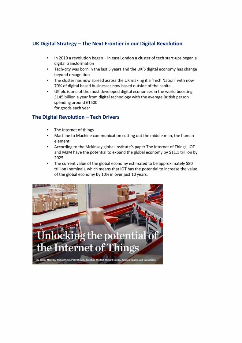
UK Digital Strategy – The Next Frontier in our Digital Revolution
In 2010 a revolution began – in east London a cluster of tech start-ups began adigital transformation
Tech-city was born in the last 5 years and the UK’S digital economy has changebeyond recognition
The cluster has now spread across the UK making it a ‘Tech Nation’ with now70% of digital based businesses now based outside of the capital.
UK plc is one of the most developed digital economies in the world boosting£145 billion a year from digital technology with the average British personspending around £1500for goods each year
The Digital Revolution – Tech Drivers
The Internet of things Machine to Machine communication cutting out the middle man, the human
element According to the Mckinsey global institute’s paper The Internet of Things, IOT
and M2M have the potential to expand the global economy by $11.1 trillion by2025
The current value of the global economy estimated to be approximately $80trillion (nominal), which means that IOT has the potential to increase the valueof the global economy by 10% in over just 10 years.
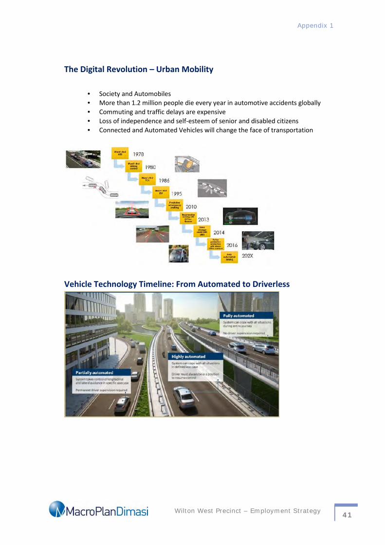
Appendix 1
Wilton West Precinct – Employment Strategy 41
The Digital Revolution – Urban Mobility
Society and Automobiles More than 1.2 million people die every year in automotive accidents globally Commuting and traffic delays are expensive Loss of independence and self-esteem of senior and disabled citizens Connected and Automated Vehicles will change the face of transportation
Vehicle Technology Timeline: From Automated to Driverless

Appendix D: Mingara Club, Central Coast
Mingara was formed back in 1971, the Central Coast was a holiday and retirement destination,with limited infrastructure and community projects.
In 1987 44.6 hectares of land was purchased on Wyong Road at Tumbi Umbi, the location of
the existing Club. By July 1995, construction new complex had commenced. At that stage the
Club’s membership had reached more than 20,000.
An integral part of the new development was the Mingara Leisure Centre. To establish this
facility, the Club entered into a joint venture with Wyong Shire Council, who contributed $4
million to the 50-metre swimming pool. This business relationship with a "Council’ is the first
of its kind in New South Wales.
In 2000, construction was completed of the Gatorade Regional Athletics Centre, a world-class
synthetic track and field athletics facility and national standard playing field. The Centre has a
unique funding partnership that evolved between Central Coast Athletics, Wyong Shire
Council, Gosford City Council, the NSW Government and Mingara Recreation Club.
In July 2002 Mingara embarked on a major expansion and refurbishment of the clubs facilities
to include a new restaurant, café, expansion and relocation of the gaming lounge, expansion
of the lounge and an upgrade of all bars. Further renovations took place at Mingara in 2007
with the opening of 3 new restaurants.
In October 2008, construction of the new Mingara One Fitness Centre was completed, the
project worth $6.5 million. Stage 2 of the project was completed in February 2009 and
included a Wellness Centre, housing a physiotherapist, hairdresser, beauty therapist, health
cafe and martial arts studio.
Today, Mingara Leisure Group is the social and sporting hub for over 55,000 members.
Appendix 1
Wilton West Precinct – Employment Strategy 43
Appendix E: ABS 2011 Business and EmploymentAnalysis
Case Study 1: North Lakes (Queensland)
Change in Employment
IndustryCode Industry Name 2006 2011 Change in Employment
no. no. no. %E Construction 391 846 455 116.4%P Education and Training 295 635 340 115.3%
QHealth Care and SocialAssistance 456 1261 805 176.5%
Case Study 2: Springfield (Queensland)
Total Change in Number of Business 2011 – 2015
Change in Employment
Industry Code Industry Name 2006 2011 Change in Employmentno. no. no. %
E Construction 216 248 32 14.8%P Education and Training 152 191 39 25.7%
QHealth Care and SocialAssistance 257 400 143 55.6%
IndustryCode Industry Name
Total2011
Total2015
Change2011-15 Total Growth
E Construction 75 58 -17 -22.7%P Education and Training 0 11 11 -
QHealth Care and SocialAssistance 18 26 8 44.4%
Case Study 3: Camden - Local
Total Change in Number of Business 2011 – 2015
IndustryCode Industry Name Total 2011
Total2015
Change 2011-15 Total Growth
E Construction 1,192 1,352 160 13.4%P Education and Training 78 72 -6 -7.7%
QHealth Care and SocialAssistance 183 232 49 26.8%
Change in Employment
Industry Code Industry Name 2006 2011 Change in Employmentno. no. no. %
E Construction 2,386 2,907 521 21.8%P Education and Training 2,107 2,780 673 31.9%
QHealth Care and SocialAssistance 2,181 2,904 723 33.1%
Case Study 4: Campbelltown - Local
Total Change in Number of Business 2011 – 2015
Industry Code Industry NameTotal2011 Total 2015
Change 2011-15
TotalGrowth
E Construction 1,748 1,706 -42 -2.4%P Education and Training 128 113 -15 -11.7%Q Health Care and Social Assistance 395 498 103 26.1%
Change in Employment
Industry Code Industry Name 2006 2011 Change in Employmentno. no. no. %
E Construction 4,532 4,545 13 0.29%P Education and Training 4,027 4,351 324 8.05%
QHealth Care and SocialAssistance 5,532 6,768 1,236 22.34%
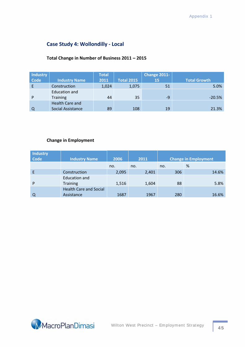
Appendix 1
Wilton West Precinct – Employment Strategy 45
Case Study 4: Wollondilly - Local
Total Change in Number of Business 2011 – 2015
Change in Employment
IndustryCode Industry Name 2006 2011 Change in Employment
no. no. no. %E Construction 2,095 2,401 306 14.6%
PEducation andTraining 1,516 1,604 88 5.8%
QHealth Care and SocialAssistance 1687 1967 280 16.6%
IndustryCode Industry Name
Total2011 Total 2015
Change 2011-15 Total Growth
E Construction 1,024 1,075 51 5.0%
PEducation andTraining 44 35 -9 -20.5%
QHealth Care andSocial Assistance 89 108 19 21.3%
MelbourneLevel 16
330 Collins Street
Melbourne VIC 3000
(03) 9600 0500
SydneyLevel 6
39 Martin Place
Sydney NSW 2000
(02) 9221 5211
Gold CoastLevel 2, The Wave,
89-91 Surf Parade
Broadbeach, QLD
BrisbaneLevel 15,
111 Eagle Street
Brisbane , QLD
(07) 3221 8166
PerthLevel 1,
89 St Georges Terrace,
Perth, WA 6000
(08) 9225 7200

Appendix 1
Wilton West Precinct – Employment Strategy 47

APPENDIX 2
Letter from Minister for Planning dated 1 November 2013

APPENDIX 3
Wilton Junction Precinct State Environmental Planning Policy Study Requirements dated 2 May 2013
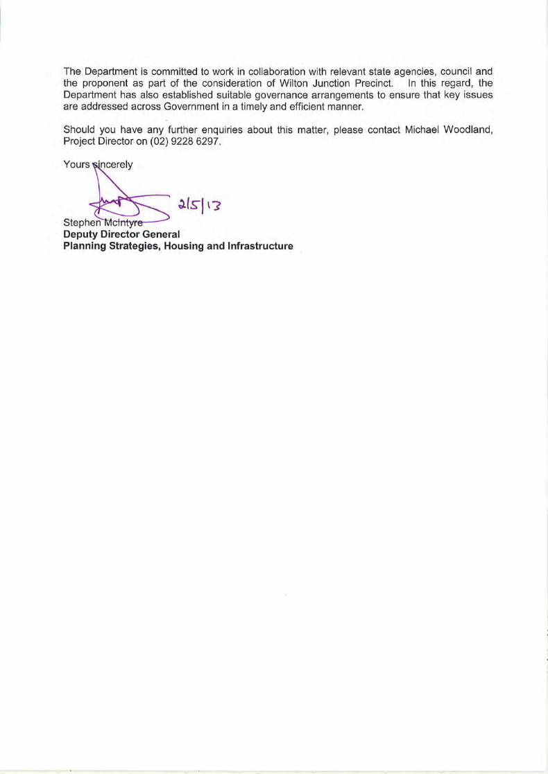
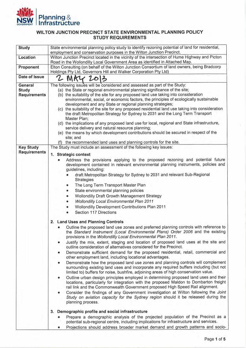
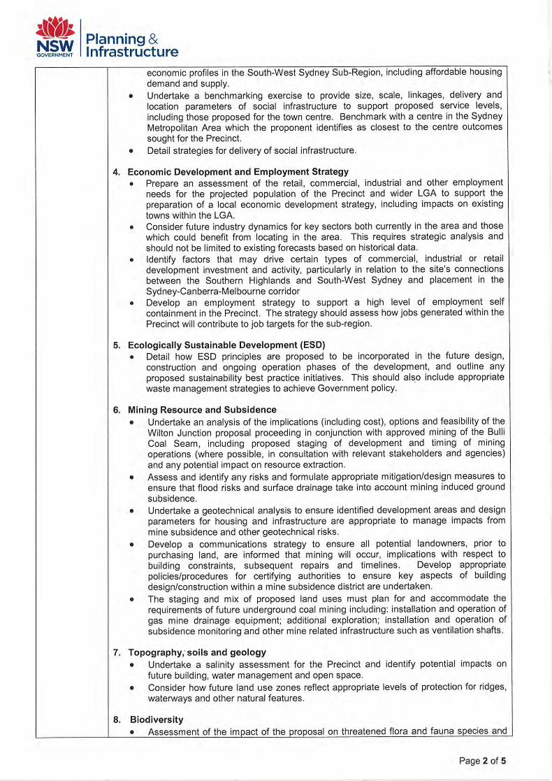
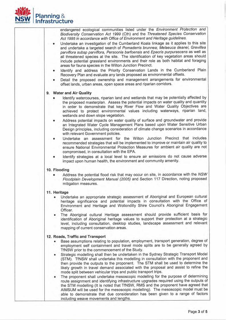
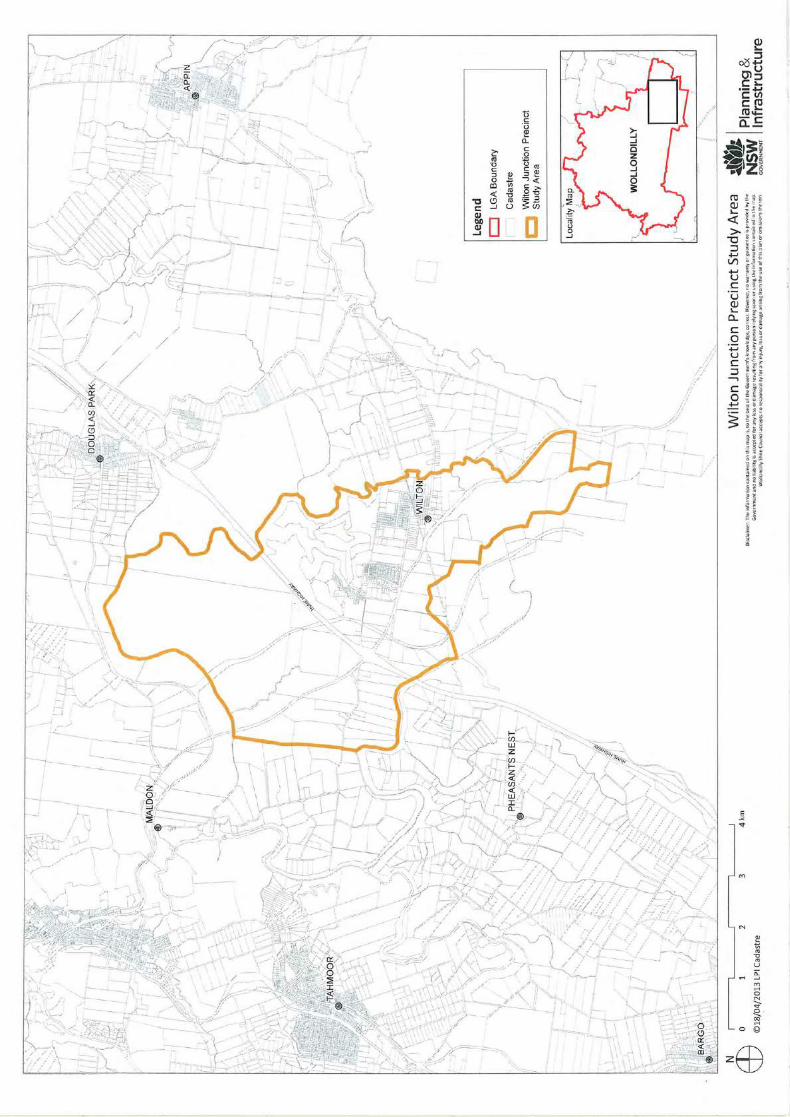

APPENDIX 4
Summary of Department of Planning & Environment Response to Wilton Junction Studies dated August 2016
Studies prepared by proponents for Wilton Junction M
asterplan
Departm
ent of Planning an
d Environment an
d W
ollo
ndilly Council comments ‐ Augu
st 2016
1/3 W
ilton Junction studies ‐ Commen
ts from Dep
artm
ent of Plannining an
d Environmen
t an
d W
ollo
ndilly Sh
ire Council
Auth
or
Topi
c Co
mm
ent f
rom
Elto
n Co
nsul
ting
Com
men
t fro
m W
ollo
ndill
y Co
unci
l and
D
epar
tmen
t of P
lann
ing
and
Envi
ronm
ent
Atk
ins
Acou
stics
No
ise Im
pact
As
sess
men
t Re
ceive
d co
mm
ents
. Rep
ort
upda
ted
and
DGR
adeq
uate
ly ad
dres
sed
Chec
k if
any
impl
icatio
ns a
risin
g fro
m la
test
veh
icle
mov
emen
t for
ecas
ts fr
om R
MS.
If v
olum
es h
ave
incr
ease
d pr
edict
ed im
pact
s an
d m
itiga
tion
mea
sure
s m
ay n
eed
upda
ting.
BG
&E
Infra
stru
ctur
e Se
rvin
g an
d St
agin
g Pl
an
Rece
ived
com
men
ts. R
epor
t up
date
d an
d DG
R ad
equa
tely
addr
esse
d
Refle
ct n
ew ti
min
g an
d st
agin
g an
d an
y ne
w w
ater
an
d w
aste
wat
er s
trate
gy o
f Syd
ney
Wat
er
Conn
or H
olm
es
Mas
ter P
lan
Repo
rt
Rece
ived
com
men
ts. R
epor
t up
date
d an
d DG
R ad
equa
tely
addr
esse
d
Refle
ct a
ny c
hang
es a
risin
g fro
m L
and
Use
and
Infra
stru
ctur
e St
rate
gy
Conn
or H
olm
es
Visu
al Im
pact
Ana
lysis
Re
ceiv
ed c
omm
ents
. Rep
ort
upda
ted
and
DGR
adeq
uate
ly ad
dres
sed
Revi
se if
any
noi
se m
itiga
tion
requ
ires
addi
tiona
l ac
oust
ic ba
rrier
s.
Doug
las
Partn
ers
Co
ntam
inat
ion
Repo
rt
Rece
ived
com
men
ts. R
epor
t up
date
d an
d DG
R ad
equa
tely
No
nee
d to
upd
ate
Eco-
Sust
aina
ble
Was
te M
anag
emen
t Re
ceiv
ed c
omm
ents
. Rep
ort
upda
ted
and
DGR
adeq
uate
ly No
nee
d to
upd
ate
Elto
n Co
nsul
ting
Ecol
ogica
l Sus
tain
able
De
velo
pmen
t Re
ceive
d co
mm
ents
. Rep
ort
upda
ted
and
DGR
adeq
uate
ly ad
dres
sed.
No n
eed
to u
pdat
e
Elto
n Co
nsul
ting
Envir
onm
enta
l Tru
st
Rece
ived
M
odel
to b
e co
nsid
ered
El
ton
Cons
ultin
g M
inin
g Co
mm
unica
tions
St
rate
gy
Rece
ived
com
men
ts. R
epor
t up
date
d an
d DG
R ad
equa
tely
To b
e re
visite
d af
ter C
abin
et S
ubm
issio
n
Elto
n Co
nsul
ting
SEPP
Rez
onin
g Pl
anni
ng R
epor
t Re
ceive
d co
mm
ents
. Rep
ort
upda
ted
and
DGR
adeq
uate
ly No
long
er n
eede
d
Elto
n Co
nsul
ting
Socia
l Inf
rast
ruct
ure
Asse
ssm
ent R
epor
t Re
ceive
d co
mm
ents
. Rep
ort
upda
ted
and
DGR
adeq
uate
ly M
ay n
eed
to u
pdat
e to
refle
ct fi
nal G
HD re
port
Elto
n Co
nsul
ting
Stat
emen
t of I
nten
t
No n
eed
to u
pdat
e El
ton
Cons
ultin
g an
d Ve
nton
Ga
s Pi
pelin
e
Rece
ived
com
men
ts. R
epor
t up
date
d an
d DG
R ad
equa
tely
addr
esse
d
No n
eed
to u
pdat
e

Studies prepared by proponents for Wilton Junction M
asterplan
Departm
ent of Planning an
d Environment an
d W
ollo
ndilly Council comments ‐ Augu
st 2016
2/3 W
ilton Junction studies ‐ Commen
ts from Dep
artm
ent of Plannining an
d Environmen
t an
d W
ollo
ndilly Sh
ire Council
Auth
or
Topi
c Co
mm
ent f
rom
Elto
n Co
nsul
ting
Com
men
t fro
m W
ollo
ndill
y Co
unci
l and
D
epar
tmen
t of P
lann
ing
and
Envi
ronm
ent
IMC
W
ilton
Junc
tion
Co-
exist
ence
and
Min
ing
Plan
Rece
ived
com
men
ts. R
epor
t up
date
d an
d DG
R ad
equa
tely
addr
esse
d
No n
eed
to u
pdat
e –
sepa
rate
inve
stig
atio
ns to
be
requ
este
d
J. W
yndh
am P
rince
W
ater
Cyc
le
Man
agem
ent
Rece
ived
com
men
ts. R
epor
t up
date
d an
d DG
R ad
equa
tely
addr
esse
d
To b
e up
date
d to
refle
ct p
ropo
sed
serv
icing
stra
tegy
if
it ch
ange
s an
d an
y fin
ding
s of
GHD
stra
tegi
c w
ater
st
udy.
Ka
yand
el
Herit
age
Repo
rt
Rece
ived
com
men
ts. R
epor
t up
date
d an
d DG
R ad
equa
tely
addr
esse
d
No n
eed
to u
pdat
e
Mac
roPl
an
Econ
omic
Deve
lopm
ent
and
Empl
oym
ent
Stra
tegy
Rece
ived
com
men
ts. R
epor
t up
date
d an
d DG
R ad
equa
tely
addr
esse
d
Furth
er w
ork
may
be
requ
ired
to e
stab
lish
empl
oym
ent
gene
ratin
g st
rate
gy
Mac
roPl
an
Empl
oym
ent
Proj
ectio
ns a
nd L
and
Need
Rece
ived
com
men
ts. R
epor
t up
date
d an
d DG
R ad
equa
tely
addr
esse
d
Upda
te if
requ
ired
Mac
roPl
an
Hous
ing
and
Popu
latio
n Pr
ojec
tions
Re
ceive
d co
mm
ents
. Rep
ort
upda
ted
and
DGR
adeq
uate
ly ad
dres
sed
Upda
te if
requ
ired
MSE
C
Min
ing
Subs
iden
ce
Repo
rt
Rece
ived
com
men
ts. R
epor
t up
date
d an
d DG
R ad
equa
tely
addr
esse
d
No n
eed
to u
pdat
e, s
epar
ate
stud
y re
ques
ted
MW
H
Was
tew
ater
Stra
tegy
Re
ceiv
ed c
omm
ents
. Rep
ort
upda
ted
and
DGR
adeq
uate
ly ad
dres
sed
Upda
te to
refle
ct th
e cu
rrent
stra
tegy
MW
H
Wat
er S
trate
gy R
epor
t Re
ceive
d co
mm
ents
. Rep
ort
upda
ted
and
DGR
adeq
uate
ly ad
dres
sed
Upda
te to
refle
ct th
e cu
rrent
stra
tegy
Pars
ons
Brin
cker
hoff
Tr
ansp
ort M
anag
emen
t Ac
cess
ibilit
y Pl
an
Rece
ived
com
men
ts. R
epor
t up
date
d an
d DG
R ad
equa
tely
addr
esse
d
Upda
te to
refle
ct P
icton
Roa
d st
rate
gy a
nd c
urre
nt
yield
s an
d st
agin
g
SLR
Cons
ultin
g
Air Q
ualit
y Im
pact
As
sess
men
t Re
ceive
d co
mm
ents
. Rep
ort
upda
ted
and
DGR
adeq
uate
ly ad
dres
sed
No n
eed
to u
pdat
e un
less
Air
Qual
ity T
ask
Forc
e re
ques
ts s
ite s
pecif
ic m
easu
res
SLR
Cons
ultin
g
Ecol
ogica
l Ass
essm
ent
Rece
ived
com
men
ts. A
dditi
onal
Su
pers
eded
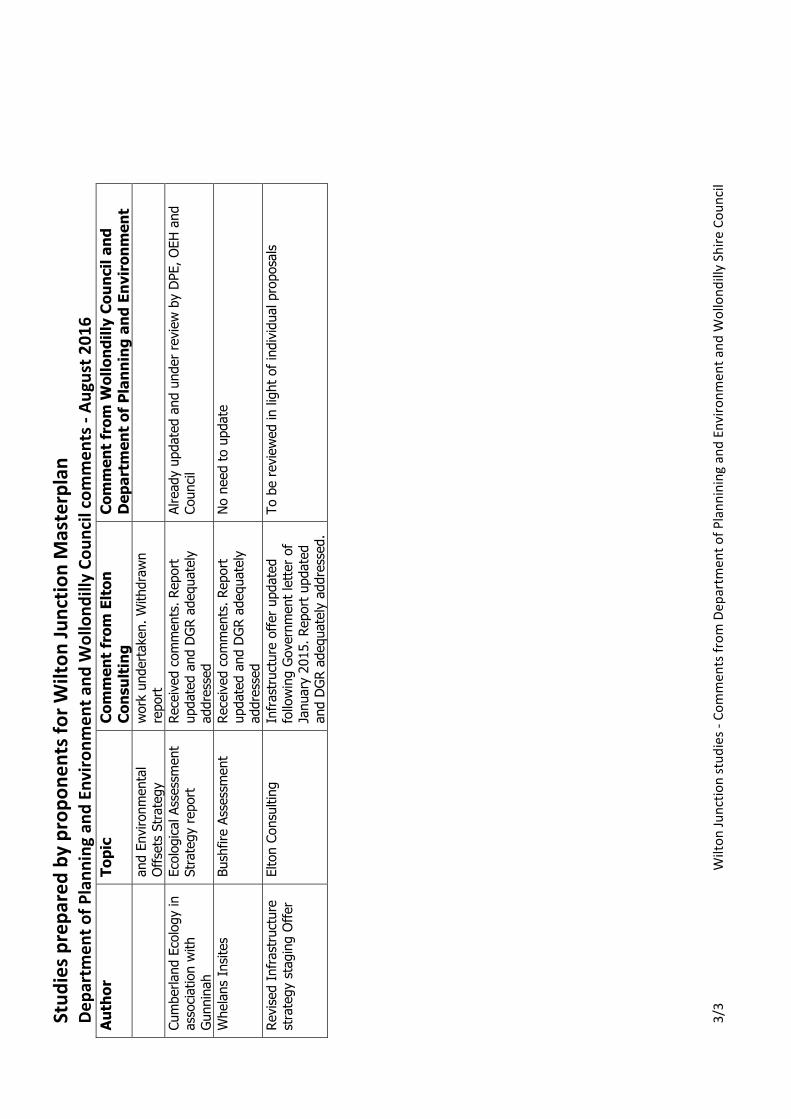
Studies prepared by proponents for Wilton Junction M
asterplan
Departm
ent of Planning an
d Environment an
d W
ollo
ndilly Council comments ‐ Augu
st 2016
3/3 W
ilton Junction studies ‐ Commen
ts from Dep
artm
ent of Plannining an
d Environmen
t an
d W
ollo
ndilly Sh
ire Council
Auth
or
Topi
c Co
mm
ent f
rom
Elto
n Co
nsul
ting
Com
men
t fro
m W
ollo
ndill
y Co
unci
l and
D
epar
tmen
t of P
lann
ing
and
Envi
ronm
ent
and
Envi
ronm
enta
l Of
fset
s St
rate
gy
wor
k un
derta
ken.
With
draw
n re
port
Cu
mbe
rland
Eco
logy
in
asso
ciatio
n w
ith
Gunn
inah
Ecol
ogica
l Ass
essm
ent
Stra
tegy
repo
rt
Rece
ived
com
men
ts. R
epor
t up
date
d an
d DG
R ad
equa
tely
addr
esse
d
Alre
ady
upda
ted
and
unde
r rev
iew
by
DPE,
OEH
and
Co
uncil
Whe
lans
Insit
es
Bush
fire
Asse
ssm
ent
Rece
ived
com
men
ts. R
epor
t up
date
d an
d DG
R ad
equa
tely
addr
esse
d
No n
eed
to u
pdat
e
Revis
ed In
frast
ruct
ure
stra
tegy
sta
ging
Offe
r El
ton
Cons
ultin
g
Infra
stru
ctur
e of
fer u
pdat
ed
follo
win
g Go
vern
men
t let
ter o
f Ja
nuar
y 20
15. R
epor
t upd
ated
an
d DG
R ad
equa
tely
addr
esse
d.
To b
e re
view
ed in
ligh
t of i
ndivi
dual
pro
posa
ls

APPENDIX 5
Summary of Wilton Junction Reports
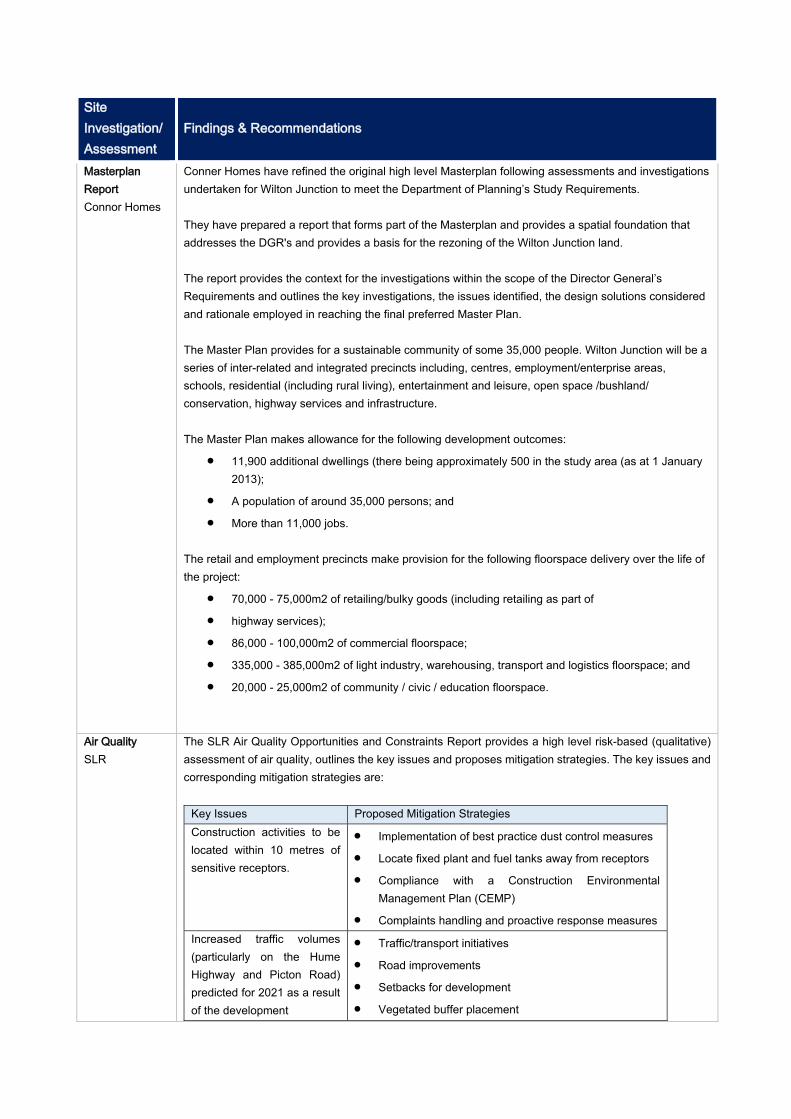
Site Investigation/ Assessment
Findings & Recommendations
Masterplan Report Connor Homes
Conner Homes have refined the original high level Masterplan following assessments and investigations undertaken for Wilton Junction to meet the Department of Planning’s Study Requirements. They have prepared a report that forms part of the Masterplan and provides a spatial foundation that addresses the DGR's and provides a basis for the rezoning of the Wilton Junction land. The report provides the context for the investigations within the scope of the Director General’s Requirements and outlines the key investigations, the issues identified, the design solutions considered and rationale employed in reaching the final preferred Master Plan. The Master Plan provides for a sustainable community of some 35,000 people. Wilton Junction will be a series of inter-related and integrated precincts including, centres, employment/enterprise areas, schools, residential (including rural living), entertainment and leisure, open space /bushland/ conservation, highway services and infrastructure. The Master Plan makes allowance for the following development outcomes:
11,900 additional dwellings (there being approximately 500 in the study area (as at 1 January 2013);
A population of around 35,000 persons; and More than 11,000 jobs.
The retail and employment precincts make provision for the following floorspace delivery over the life of the project:
70,000 - 75,000m2 of retailing/bulky goods (including retailing as part of highway services); 86,000 - 100,000m2 of commercial floorspace; 335,000 - 385,000m2 of light industry, warehousing, transport and logistics floorspace; and 20,000 - 25,000m2 of community / civic / education floorspace.
Air Quality SLR
The SLR Air Quality Opportunities and Constraints Report provides a high level risk-based (qualitative) assessment of air quality, outlines the key issues and proposes mitigation strategies. The key issues and corresponding mitigation strategies are:
Key Issues Proposed Mitigation Strategies Construction activities to be located within 10 metres of sensitive receptors.
Implementation of best practice dust control measures Locate fixed plant and fuel tanks away from receptors Compliance with a Construction Environmental
Management Plan (CEMP) Complaints handling and proactive response measures
Increased traffic volumes (particularly on the Hume Highway and Picton Road) predicted for 2021 as a result of the development
Traffic/transport initiatives Road improvements Setbacks for development Vegetated buffer placement
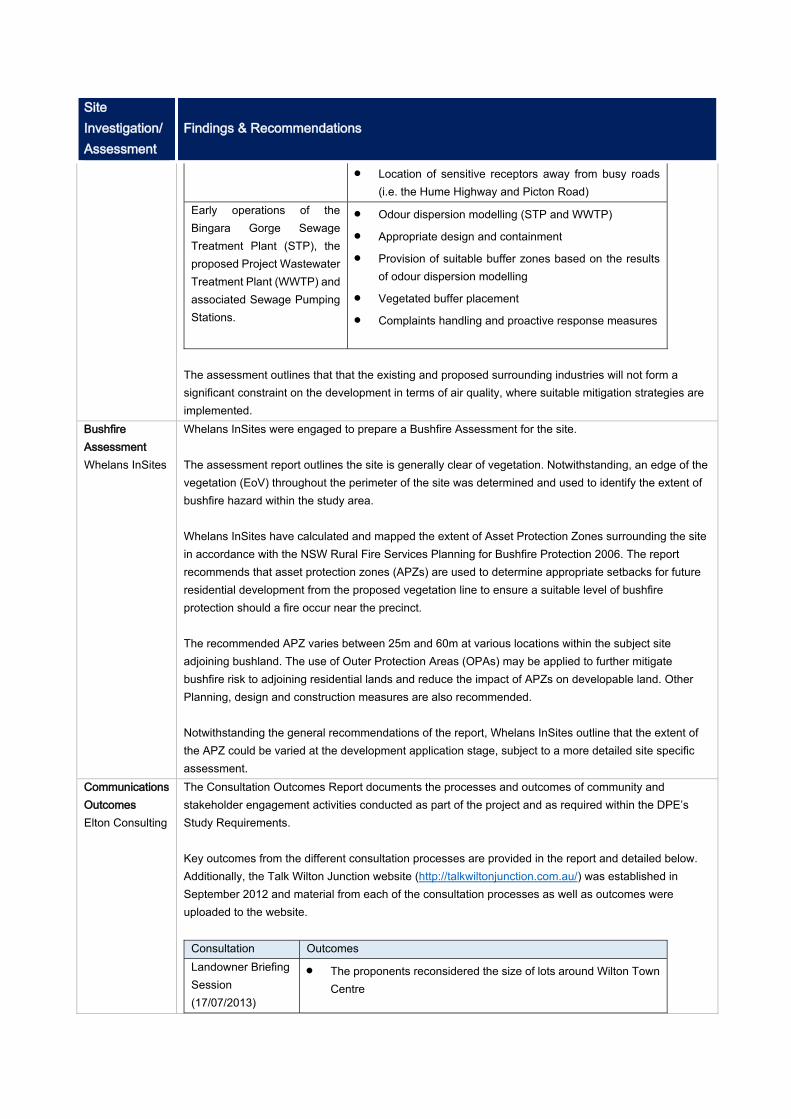
Site Investigation/ Assessment
Findings & Recommendations
Location of sensitive receptors away from busy roads (i.e. the Hume Highway and Picton Road)
Early operations of the Bingara Gorge Sewage Treatment Plant (STP), the proposed Project Wastewater Treatment Plant (WWTP) and associated Sewage Pumping Stations.
Odour dispersion modelling (STP and WWTP) Appropriate design and containment Provision of suitable buffer zones based on the results
of odour dispersion modelling Vegetated buffer placement Complaints handling and proactive response measures
The assessment outlines that that the existing and proposed surrounding industries will not form a significant constraint on the development in terms of air quality, where suitable mitigation strategies are implemented.
Bushfire Assessment Whelans InSites
Whelans InSites were engaged to prepare a Bushfire Assessment for the site. The assessment report outlines the site is generally clear of vegetation. Notwithstanding, an edge of the vegetation (EoV) throughout the perimeter of the site was determined and used to identify the extent of bushfire hazard within the study area. Whelans InSites have calculated and mapped the extent of Asset Protection Zones surrounding the site in accordance with the NSW Rural Fire Services Planning for Bushfire Protection 2006. The report recommends that asset protection zones (APZs) are used to determine appropriate setbacks for future residential development from the proposed vegetation line to ensure a suitable level of bushfire protection should a fire occur near the precinct. The recommended APZ varies between 25m and 60m at various locations within the subject site adjoining bushland. The use of Outer Protection Areas (OPAs) may be applied to further mitigate bushfire risk to adjoining residential lands and reduce the impact of APZs on developable land. Other Planning, design and construction measures are also recommended. Notwithstanding the general recommendations of the report, Whelans InSites outline that the extent of the APZ could be varied at the development application stage, subject to a more detailed site specific assessment.
Communications Outcomes Elton Consulting
The Consultation Outcomes Report documents the processes and outcomes of community and stakeholder engagement activities conducted as part of the project and as required within the DPE’s Study Requirements. Key outcomes from the different consultation processes are provided in the report and detailed below. Additionally, the Talk Wilton Junction website (http://talkwiltonjunction.com.au/) was established in September 2012 and material from each of the consultation processes as well as outcomes were uploaded to the website.
Consultation Outcomes Landowner Briefing Session (17/07/2013)
The proponents reconsidered the size of lots around Wilton Town Centre
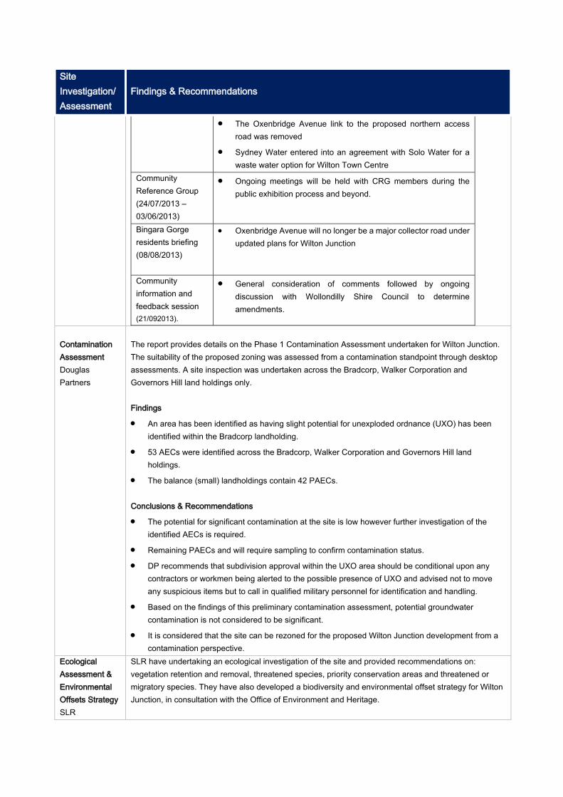
Site Investigation/ Assessment
Findings & Recommendations
The Oxenbridge Avenue link to the proposed northern access road was removed
Sydney Water entered into an agreement with Solo Water for a waste water option for Wilton Town Centre
Community Reference Group (24/07/2013 – 03/06/2013)
Ongoing meetings will be held with CRG members during the public exhibition process and beyond.
Bingara Gorge residents briefing (08/08/2013)
Oxenbridge Avenue will no longer be a major collector road under updated plans for Wilton Junction
Community information and feedback session (21/092013).
General consideration of comments followed by ongoing discussion with Wollondilly Shire Council to determine amendments.
Contamination Assessment Douglas Partners
The report provides details on the Phase 1 Contamination Assessment undertaken for Wilton Junction. The suitability of the proposed zoning was assessed from a contamination standpoint through desktop assessments. A site inspection was undertaken across the Bradcorp, Walker Corporation and Governors Hill land holdings only. Findings An area has been identified as having slight potential for unexploded ordnance (UXO) has been
identified within the Bradcorp landholding. 53 AECs were identified across the Bradcorp, Walker Corporation and Governors Hill land
holdings. The balance (small) landholdings contain 42 PAECs. Conclusions & Recommendations The potential for significant contamination at the site is low however further investigation of the
identified AECs is required. Remaining PAECs and will require sampling to confirm contamination status. DP recommends that subdivision approval within the UXO area should be conditional upon any
contractors or workmen being alerted to the possible presence of UXO and advised not to move any suspicious items but to call in qualified military personnel for identification and handling.
Based on the findings of this preliminary contamination assessment, potential groundwater contamination is not considered to be significant.
It is considered that the site can be rezoned for the proposed Wilton Junction development from a contamination perspective.
Ecological Assessment & Environmental Offsets Strategy SLR
SLR have undertaking an ecological investigation of the site and provided recommendations on: vegetation retention and removal, threatened species, priority conservation areas and threatened or migratory species. They have also developed a biodiversity and environmental offset strategy for Wilton Junction, in consultation with the Office of Environment and Heritage.
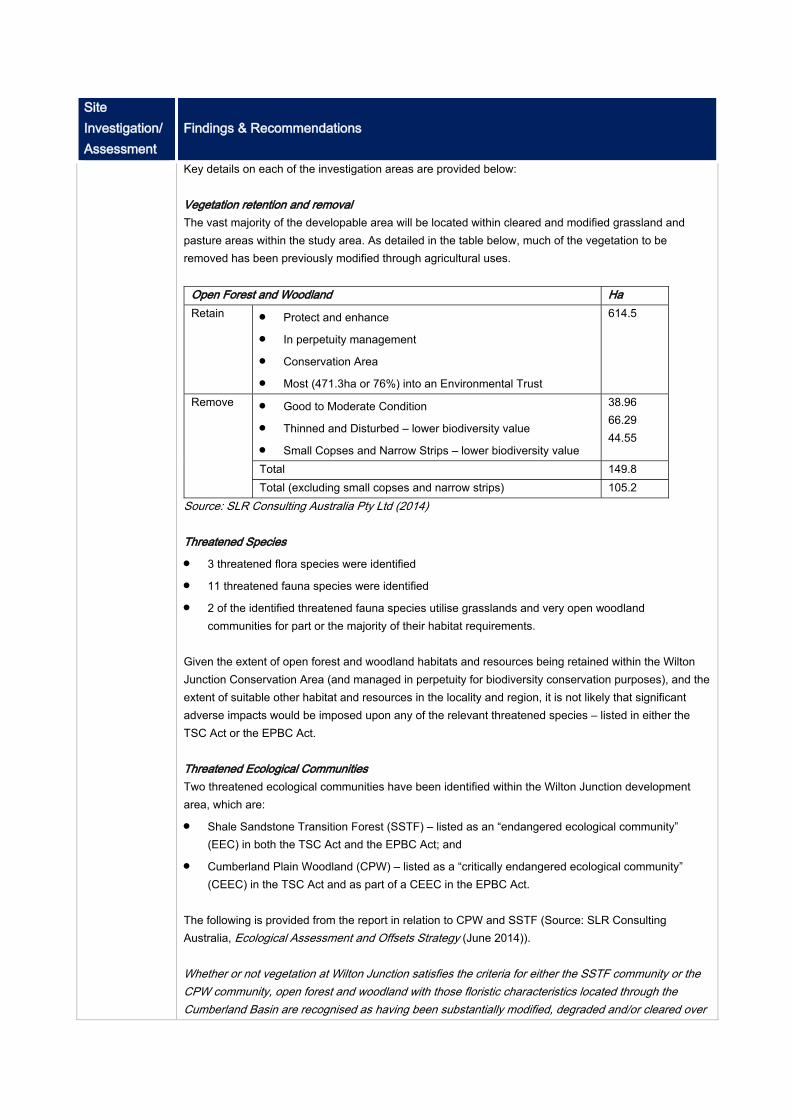
Site Investigation/ Assessment
Findings & Recommendations
Key details on each of the investigation areas are provided below: Vegetation retention and removal The vast majority of the developable area will be located within cleared and modified grassland and pasture areas within the study area. As detailed in the table below, much of the vegetation to be removed has been previously modified through agricultural uses.
Open Forest and Woodland Ha Retain Protect and enhance
In perpetuity management Conservation Area Most (471.3ha or 76%) into an Environmental Trust
614.5
Remove Good to Moderate Condition Thinned and Disturbed – lower biodiversity value Small Copses and Narrow Strips – lower biodiversity value
38.96 66.29 44.55
Total 149.8 Total (excluding small copses and narrow strips) 105.2
Source: SLR Consulting Australia Pty Ltd (2014) Threatened Species 3 threatened flora species were identified 11 threatened fauna species were identified 2 of the identified threatened fauna species utilise grasslands and very open woodland
communities for part or the majority of their habitat requirements.
Given the extent of open forest and woodland habitats and resources being retained within the Wilton Junction Conservation Area (and managed in perpetuity for biodiversity conservation purposes), and the extent of suitable other habitat and resources in the locality and region, it is not likely that significant adverse impacts would be imposed upon any of the relevant threatened species – listed in either the TSC Act or the EPBC Act. Threatened Ecological Communities Two threatened ecological communities have been identified within the Wilton Junction development area, which are: Shale Sandstone Transition Forest (SSTF) – listed as an “endangered ecological community”
(EEC) in both the TSC Act and the EPBC Act; and Cumberland Plain Woodland (CPW) – listed as a “critically endangered ecological community”
(CEEC) in the TSC Act and as part of a CEEC in the EPBC Act.
The following is provided from the report in relation to CPW and SSTF (Source: SLR Consulting Australia, Ecological Assessment and Offsets Strategy (June 2014)). Whether or not vegetation at Wilton Junction satisfies the criteria for either the SSTF community or the CPW community, open forest and woodland with those floristic characteristics located through the Cumberland Basin are recognised as having been substantially modified, degraded and/or cleared over
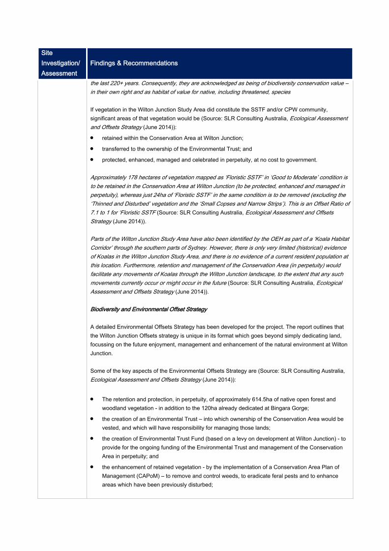
Site Investigation/ Assessment
Findings & Recommendations
the last 220+ years. Consequently, they are acknowledged as being of biodiversity conservation value – in their own right and as habitat of value for native, including threatened, species If vegetation in the Wilton Junction Study Area did constitute the SSTF and/or CPW community, significant areas of that vegetation would be (Source: SLR Consulting Australia, Ecological Assessment and Offsets Strategy (June 2014)): retained within the Conservation Area at Wilton Junction; transferred to the ownership of the Environmental Trust; and protected, enhanced, managed and celebrated in perpetuity, at no cost to government. Approximately 178 hectares of vegetation mapped as ‘Floristic SSTF’ in ‘Good to Moderate’ condition is to be retained in the Conservation Area at Wilton Junction (to be protected, enhanced and managed in perpetuity), whereas just 24ha of ‘Floristic SSTF’ in the same condition is to be removed (excluding the ‘Thinned and Disturbed’ vegetation and the ‘Small Copses and Narrow Strips’). This is an Offset Ratio of 7.1 to 1 for ‘Floristic SSTF (Source: SLR Consulting Australia, Ecological Assessment and Offsets Strategy (June 2014)). Parts of the Wilton Junction Study Area have also been identified by the OEH as part of a ‘Koala Habitat Corridor’ through the southern parts of Sydney. However, there is only very limited (historical) evidence of Koalas in the Wilton Junction Study Area, and there is no evidence of a current resident population at this location. Furthermore, retention and management of the Conservation Area (in perpetuity) would facilitate any movements of Koalas through the Wilton Junction landscape, to the extent that any such movements currently occur or might occur in the future (Source: SLR Consulting Australia, Ecological Assessment and Offsets Strategy (June 2014)). Biodiversity and Environmental Offset Strategy A detailed Environmental Offsets Strategy has been developed for the project. The report outlines that the Wilton Junction Offsets strategy is unique in its format which goes beyond simply dedicating land, focussing on the future enjoyment, management and enhancement of the natural environment at Wilton Junction. Some of the key aspects of the Environmental Offsets Strategy are (Source: SLR Consulting Australia, Ecological Assessment and Offsets Strategy (June 2014)): The retention and protection, in perpetuity, of approximately 614.5ha of native open forest and
woodland vegetation - in addition to the 120ha already dedicated at Bingara Gorge; the creation of an Environmental Trust – into which ownership of the Conservation Area would be
vested, and which will have responsibility for managing those lands; the creation of Environmental Trust Fund (based on a levy on development at Wilton Junction) - to
provide for the ongoing funding of the Environmental Trust and management of the Conservation Area in perpetuity; and
the enhancement of retained vegetation - by the implementation of a Conservation Area Plan of Management (CAPoM) – to remove and control weeds, to eradicate feral pests and to enhance areas which have been previously disturbed;

Site Investigation/ Assessment
Findings & Recommendations
Ecologically Sustainable Development Elton Consulting
Elton Consulting have prepared a report on the ecologically sustainable development principles and initiatives for the Wilton Junction Project. The report incorporates an assessment of the strategy prepared by Elton which has been developed in consultation with the Wilton Junction Landowners Group. The report identifies Wollondilly Shire Council’s and the NSW Government’s definitions for Ecologically Sustainable Development as sources which have informed the development of the sustainability approach for the project and assessment criteria used by Elton Consulting. The United Nation Environment Program’s ‘Melbourne Principles’ are identified as guiding principles for development of the Wilton Junction Landowners Groups sustainability objectives. Various initiatives are identified to meet the following ‘Melbourne Principles’: Principle 1: Provide a long-term vision for cities based on: sustainability; intergenerational, social,
economic and political equity; and their individuality. Principle 2: Achieve long-term economic and social security. Principle 3: Recognise the intrinsic value of biodiversity and natural ecosystems, and protect and
restore them. Principle 4: Enable communities to minimise their ecological footprint. Principle 5: Build on the characteristics of ecosystems in the development and nurturing of healthy
and sustainable cities. Principle 6: Recognise and build on the distinctive characteristics of cities, including their human
and cultural values, history and natural systems. Principle 7: Empower people and foster participation. Principle 8: Expand and enable cooperative networks to work towards a common, sustainable
future. Principle 9: Promote sustainable production and consumption, through appropriate use of
environmentally sound technologies and effective demand management. Principle 10: Enable continual improvement, based on accountability, transparency and good
governance. The Wilton Junction Landowners Group has also identified a number of best practice sustainability initiatives that will be implemented at Wilton Junction as part of the vision of a ‘garden city’ for the 21st Century. They are listed below. Whole of Environment Approach Establishment of an Environmental Trust (The primary role of the Trust is the protection of natural
and Aboriginal heritage resources. It will manage high conservation value bushland within the Study Area whilst maintaining an asset protection framework.
Innovative Infrastructure - Water Cycle Management Waste Minimisation Strategy Climate Change Adaption and Mitigation Self-containment – Various strategies to support social and economic development at Wilton
Junction

Site Investigation/ Assessment
Findings & Recommendations
Economic Development and Employment Strategy Community Development and Place Making Sustainable Transport Strategy Local Food Production Affordability The report provides an assessment of the initiatives against the ESD principles and generally demonstrates how the Wilton Junction Project will meet sustainability objectives.
Economic Development & Employment Strategy MacroPlan Dimasi
In their report, MacroPlan Dimasi have identified the potential employment drivers for Wilton Junction and outline the key strategic directions that will assist in delivering the target number of jobs for the locality. The report acknowledges that industries that are predominantly population driven including retail, social infrastructure, health care, education and public administration, employment will evolve sequentially with population growth. As such, the report focuses on strategies for attracting employment industries that require a degree of stimulation. A summary of the recommended employment strategies for sector specific industries are provided below (Source: Macroplan Dimasi, Wilton Junction Economic Development & Employment Strategy, 2014) . Health Sector - formation of business partnerships with the South Western Sydney Local Health District; the region’s private hospitals and care providers; as well as specific aged care and home care providers, preferably early in the residential precinct development cycle. Business partnerships with health equipment manufacturers and distributors. Education Sector – establish business partnerships with private schools, TAFEs and potentially involving industry training partnerships and/or enterprise partnerships with nearby facilities at UWS Campbelltown and the University of Wollongong. Educational focus on local industry needs and trades sector e.g. work with NSW Transport to
implement its Master Plan objective to maintain the state’s freight workforce through initiatives that attract and retain skilled workers in the industry.
Work with the Bureau of Freight Statistics to streamline freight data collection and strategic analysis, e.g. by liaising with freight industries to ensure their needs are understood and accommodated and that the necessary industry skills are developed, or through applied research in freight management.
Construction Sector – identification of candidate construction supply companies eager to locate at Wilton Junction to take advantage of its proximity to broader development fronts at the South West Growth Centre and in Wollongong. Work with specific supply industries to understand their training needs and partner with education
providers to create Wilton as a place of trade learning. Transport, Postal and Warehousing – maximise the broader appreciation of Wilton Junction’s natural advantages in terms of it connectedness to Sydney, Wollongong and other regions.
Site Investigation/ Assessment
Findings & Recommendations
Ensure the allocation of suitable land and simultaneous marketing to attract those businesses which have the potential to benefit from a southern Sydney regional location.
Identification and targeting of specific logistics businesses. Tourism and Recreation – work with Council’s toward the review and implementation of its Tourism Business Plan. Align current objectives to Destination NSW’s agenda to double the state’s overnight visitor
expenditure by 2020 in order that regional funding may be obtained. Develop local tourism partnership between Council and respective businesses – and seek regional
development funding from the Federal Government. Agribusiness - supporting primary production in a research, training or trading capacity. Tap into the presence of research institutions to encourage Wollondilly as a centre for innovation in the agricultural industry and/or for food production and manufacturing. Identify existing agribusinesses in Sydney’s south-west that will be impacted by encroaching urban
development to pursue their relocation to Wollondilly e.g. Inghams Enterprises, Flora International, NuFlora International and Andreasens Green.
Strategic responses are also provided to assist in the following: Planning for a competitive industry environment, facilitating industry growth (population driven industries), catalytic employment projects (benefits for smaller industries through co-location with major services), infrastructure delivery, regional partnerships and business support. The report outlines that the success of the strategy will be dependent on the ability to secure funding for the initiatives and to target specific industry types identified as possible candidate industries that could be attracted to Wollondilly. Other matters that will drive the success of the strategies relate to: The quality and inventiveness of specific marketing material; Appropriate implementation structures and arrangements; and The ongoing ownership and refinement of the initiatives.
Environmental Trust Elton Consulting
The Wilton Junction Environmental Trust is a developer led voluntary planning agreement with the State government that establishes a robust management framework to ensure protection of bio-diversity and culturally significant sites and provision for the on-going management of these resources. Elton Consulting have prepared a report on the aspects of the Environmental Trust, addressing the need for the Trust, its benefits, governance, funding and operation and how the Trust will guarantee in perpetuity protection of bio-diversity and heritage assets. As detailed in Elton’s report, the key principles of the Wilton Junction Environmental Trust are: In perpetuity funding for the care and protection of the natural environment including land
improvement, management and maintenance, while exploring opportunities to expand the income
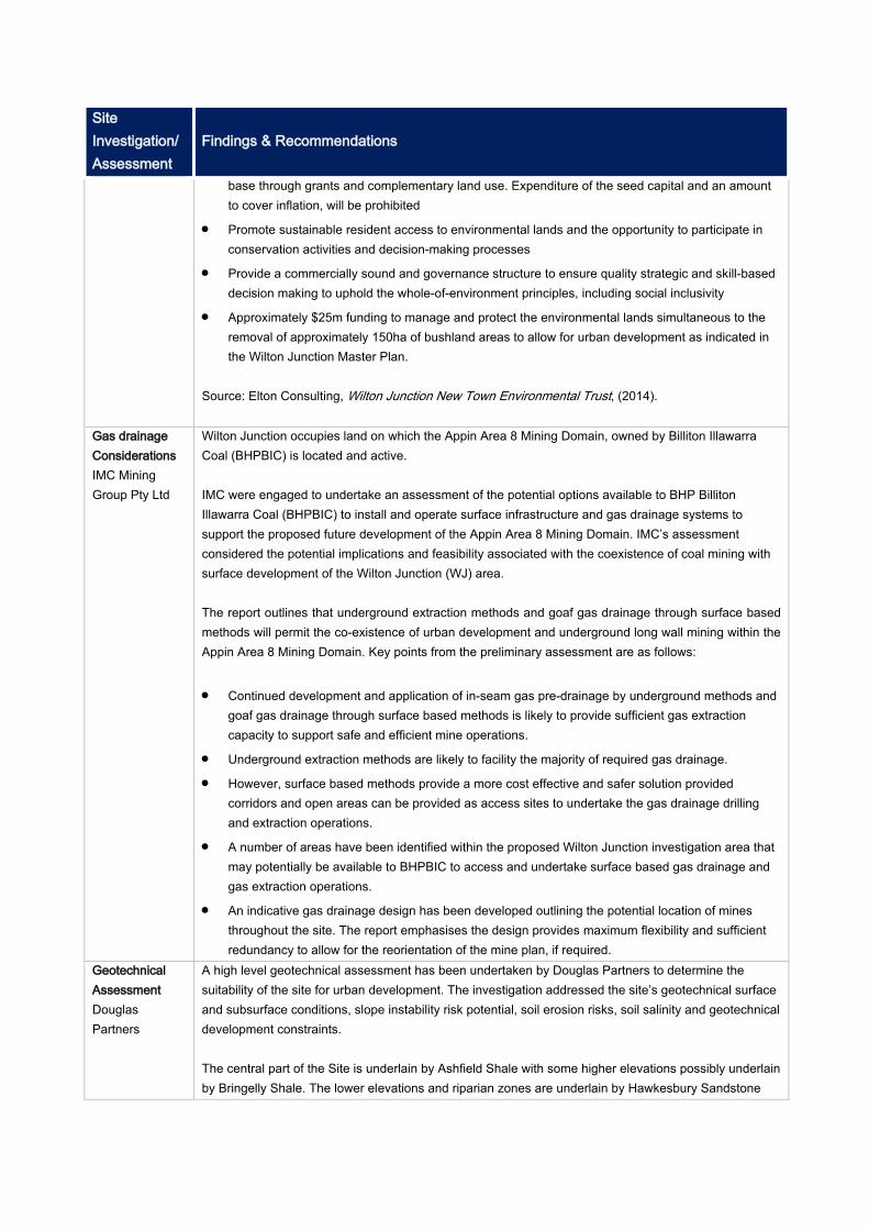
Site Investigation/ Assessment
Findings & Recommendations
base through grants and complementary land use. Expenditure of the seed capital and an amount to cover inflation, will be prohibited
Promote sustainable resident access to environmental lands and the opportunity to participate in conservation activities and decision-making processes
Provide a commercially sound and governance structure to ensure quality strategic and skill-based decision making to uphold the whole-of-environment principles, including social inclusivity
Approximately $25m funding to manage and protect the environmental lands simultaneous to the removal of approximately 150ha of bushland areas to allow for urban development as indicated in the Wilton Junction Master Plan.
Source: Elton Consulting, Wilton Junction New Town Environmental Trust, (2014).
Gas drainage Considerations IMC Mining Group Pty Ltd
Wilton Junction occupies land on which the Appin Area 8 Mining Domain, owned by Billiton Illawarra Coal (BHPBIC) is located and active. IMC were engaged to undertake an assessment of the potential options available to BHP Billiton Illawarra Coal (BHPBIC) to install and operate surface infrastructure and gas drainage systems to support the proposed future development of the Appin Area 8 Mining Domain. IMC’s assessment considered the potential implications and feasibility associated with the coexistence of coal mining with surface development of the Wilton Junction (WJ) area. The report outlines that underground extraction methods and goaf gas drainage through surface based methods will permit the co-existence of urban development and underground long wall mining within the Appin Area 8 Mining Domain. Key points from the preliminary assessment are as follows: Continued development and application of in-seam gas pre-drainage by underground methods and
goaf gas drainage through surface based methods is likely to provide sufficient gas extraction capacity to support safe and efficient mine operations.
Underground extraction methods are likely to facility the majority of required gas drainage. However, surface based methods provide a more cost effective and safer solution provided
corridors and open areas can be provided as access sites to undertake the gas drainage drilling and extraction operations.
A number of areas have been identified within the proposed Wilton Junction investigation area that may potentially be available to BHPBIC to access and undertake surface based gas drainage and gas extraction operations.
An indicative gas drainage design has been developed outlining the potential location of mines throughout the site. The report emphasises the design provides maximum flexibility and sufficient redundancy to allow for the reorientation of the mine plan, if required.
Geotechnical Assessment Douglas Partners
A high level geotechnical assessment has been undertaken by Douglas Partners to determine the suitability of the site for urban development. The investigation addressed the site’s geotechnical surface and subsurface conditions, slope instability risk potential, soil erosion risks, soil salinity and geotechnical development constraints. The central part of the Site is underlain by Ashfield Shale with some higher elevations possibly underlain by Bringelly Shale. The lower elevations and riparian zones are underlain by Hawkesbury Sandstone
Site Investigation/ Assessment
Findings & Recommendations
with the interface areas between the Ashfield Shale and Hawkesbury Sandstone underlain by Mittagong Sandstone.
The majority of the site comprises Blacktown soil. This soil type is characterised by low fertility, moderately reactive, highly plastic and generally low wet strength. The riparian areas are Lucas Heights soil, which is a residual soil landscape that comprises soils that are low fertility, stony and slightly reactive and have low available water capacity. Douglas Partners provide the following summary points based on their preliminary assessment of the site (source: Douglas Partners, Report on Geotechnical Assessment (June 2014)). No evidence of hillside/slope instability was observed within the proposed net developable area. It
is considered that such instability does not impose significant constraints on the proposed site development under the current master plan.
The presence of erosive soils on site should not present significant constraints to development provided they are well managed during earthworks and site preparation stages.
No significant evidence of saline soil was identified within the site. Although further salinity testing is considered necessary, at this stage salinity levels are sufficiently low for this site to be deemed free of no significant salinity constraints.
Although mild aggressivity to concrete is regularly encountered across the site, aggressivity levels are considered to be manageable, subject to appropriate design and construction consideration.
Highly sodic soils appear widespread and will require management to reduce dispersion, erosion and to improve drainage.
Douglas Partners outline in their report that the assessment undertaken did not identify any issue that would preclude the rezoning of the Wilton Junction site for urban development.
Douglas Partners outline the additional investigations required as the project progresses (source: Douglas Partners, Report on Geotechnical Assessment (June 2014)). Additional salinity investigations for site soils and surface waters (i.e. dams) to increase the density
of the data obtained to date. Recommendations on the methodology and intended outcomes for the investigation programme are provided.
Additional investigation should be undertaken in development areas which are to be excavated deeper than 2 m or into rock at shallower depth, where direct sampling and testing of salinity has not been carried out. Salinity management strategies should then be reassessed following additional investigation by deep test pitting and/or drilling, sampling and testing for soil and water pH, electrical conductivity, TDS, sodicity, sulphates and chlorides.
Additional testing of the site’s soils and surface water (and groundwater, if encountered) for aggressivity testing and its effects on buried concrete and steel structures.
Additional testing of site soils for erosion and dispersion properties to provide better guidance on the design and construction of future water bodies and the ability of the soils to be used as clay liners, or similar.
Detailed geotechnical investigations on a stage-by-stage basis for determination of pavement thickness designs and lot classifications, as well as stage specific issues, such as deep excavations and construction of roads and dwellings/structures on steeper landforms and crests.
Site Investigation/ Assessment
Findings & Recommendations
Routine inspections and earthworks monitoring during construction. Heritage Report Kayandel Archaeological Service
Kayandel Archaeological Service were engaged to assess the archaeological potential at the subject site and potential Aboriginal Heritage Impacts and non indigenous heritage impacts. The assessment identified a number of Aboriginal and Historic heritage items within the Subject Area. As part of the supporting material for the report, a masterplan was developed which details the location of the identified items. The Masterplan has been designed to minimise the impacts upon items that have been assessed to be of high significance. The report concludes that impacts upon items of Aboriginal heritage or items of historic heritage are not sufficient as to prevent the rezoning application currently proposed. The report confirms the level of investigation and enquiry is sufficient to provide for an assessment of the rezoning proposal to be undertaken. The recommendations contained within the report provide clear guidance on the requirements of the Heritage Act and National Parks and Wildlife Act should the rezoning proposal be determined positively and development applications proceed to be lodged in the future. The following recommendations are provided by Kayandel Archaeological Service in their report and they have been based on the relevant legal requirements and codes of practice specific to the disciple (source: Kayandel Archaeological Service, Aboriginal Cultural Heritage Assessment and Historic Heritage Assessment (June 2014)). Indigenous Heritage:
A1 - No further assessment of the Aboriginal heritage within the Subject Area is required to inform the rezoning proposal.
A2 - Prior to Development Application Stage for an identified area, further Aboriginal archaeological investigations are required at all locations identified in Figure 24. See below for further considerations for these investigations.
A3 - Any proposed impacts within the Conservation or Open Space area identified in Figure 3 (or any future version of the master plan) should be subject to separate assessment prior to the impact to assess the cumulative impact of the proposed works on Aboriginal heritage (Figure 22 and Figure 23).
A4 - An Aboriginal Heritage Impact Permit under Part 6 of the National Parks and Wildlife Act 1974 should be sought for the extent of each Development Application area. The need for an Aboriginal Heritage Impact Permit will trigger the opportunity to undertake further consultation. This Aboriginal Heritage Impact Permit should be sought for all known and unknown Aboriginal objects within the Development Application area as a strategy to minimise the risk of delays during works that may results from unexpected finds.
A5 - As a result of Recommendations 2 and 4 a process of further consultation with Aboriginal stakeholders will be required to be undertaken in accordance with the specifications of Aboriginal Cultural Heritage Consultation Requirements for Proponents (DECCW 2010a)
A6 - Those portions of the Subject Area not previously affect by high levels of ground disturbance (See Figure 8 to Figure 13) and not being subject to survey during this investigation (Figure 4) will require
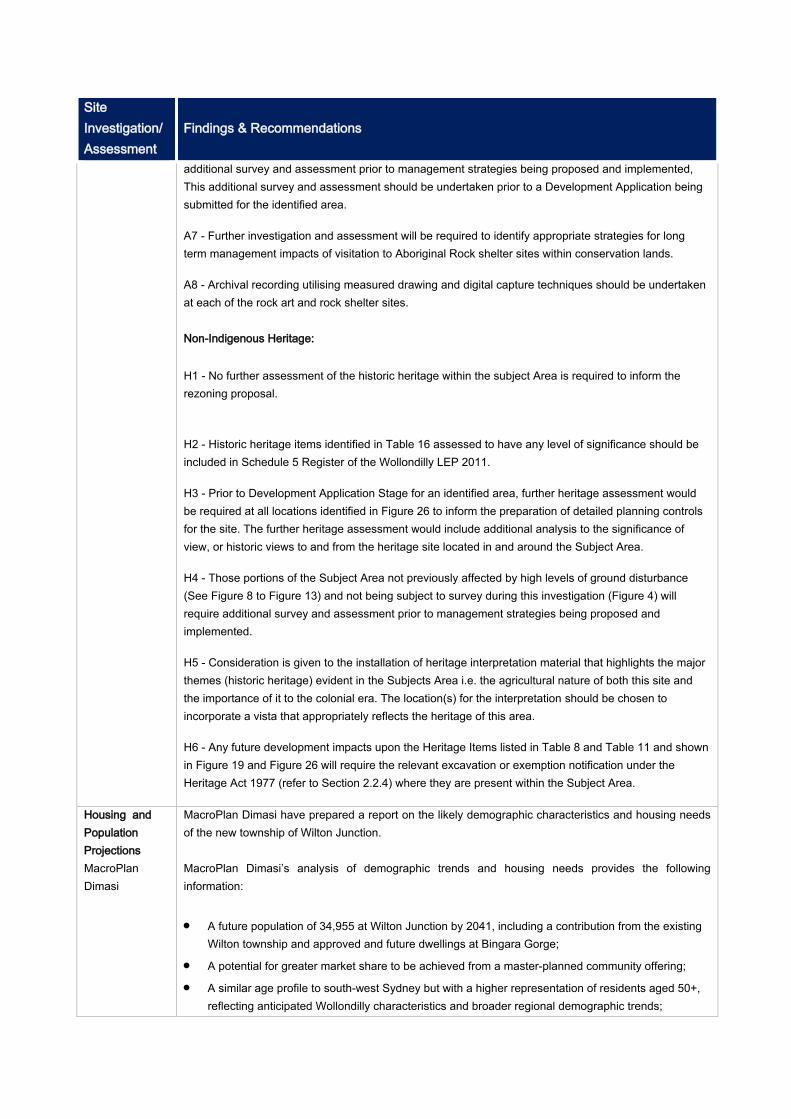
Site Investigation/ Assessment
Findings & Recommendations
additional survey and assessment prior to management strategies being proposed and implemented, This additional survey and assessment should be undertaken prior to a Development Application being submitted for the identified area.
A7 - Further investigation and assessment will be required to identify appropriate strategies for long term management impacts of visitation to Aboriginal Rock shelter sites within conservation lands.
A8 - Archival recording utilising measured drawing and digital capture techniques should be undertaken at each of the rock art and rock shelter sites. Non-Indigenous Heritage: H1 - No further assessment of the historic heritage within the subject Area is required to inform the rezoning proposal.
H2 - Historic heritage items identified in Table 16 assessed to have any level of significance should be included in Schedule 5 Register of the Wollondilly LEP 2011.
H3 - Prior to Development Application Stage for an identified area, further heritage assessment would be required at all locations identified in Figure 26 to inform the preparation of detailed planning controls for the site. The further heritage assessment would include additional analysis to the significance of view, or historic views to and from the heritage site located in and around the Subject Area.
H4 - Those portions of the Subject Area not previously affected by high levels of ground disturbance (See Figure 8 to Figure 13) and not being subject to survey during this investigation (Figure 4) will require additional survey and assessment prior to management strategies being proposed and implemented.
H5 - Consideration is given to the installation of heritage interpretation material that highlights the major themes (historic heritage) evident in the Subjects Area i.e. the agricultural nature of both this site and the importance of it to the colonial era. The location(s) for the interpretation should be chosen to incorporate a vista that appropriately reflects the heritage of this area.
H6 - Any future development impacts upon the Heritage Items listed in Table 8 and Table 11 and shown in Figure 19 and Figure 26 will require the relevant excavation or exemption notification under the Heritage Act 1977 (refer to Section 2.2.4) where they are present within the Subject Area.
Housing and Population Projections MacroPlan Dimasi
MacroPlan Dimasi have prepared a report on the likely demographic characteristics and housing needs of the new township of Wilton Junction.
MacroPlan Dimasi’s analysis of demographic trends and housing needs provides the following information: A future population of 34,955 at Wilton Junction by 2041, including a contribution from the existing
Wilton township and approved and future dwellings at Bingara Gorge; A potential for greater market share to be achieved from a master-planned community offering; A similar age profile to south-west Sydney but with a higher representation of residents aged 50+,
reflecting anticipated Wollondilly characteristics and broader regional demographic trends;

Site Investigation/ Assessment
Findings & Recommendations
A dominance of family households, with a marginally greater representation of couple families without children when compared to south-west Sydney; and
A broader trend toward smaller lots across Sydney’s south-west; A growing interest in new estate locations from retirees seeking to down-size; and A likely dominance of detached housing at Wilton Junction, but with an increasing proportion of
smaller lots to meet consumer demand for affordable product. Source: MacroPlan Dimasi, Housing and Population Projections, (2014)
Infrastructure Servicing & Staging Plan BG&E
BG&E have prepared an Infrastructure Servicing and Staging Plan that provides an overview of the infrastructure requirements to service the Wilton Junction development. The Plan has been prepared using other technical reports prepared to satisfy the DPE SR’s and in consultation with Wollondilly Shire Council and the relevant State Government infrastructure agencies. The estimated cost to provide all required infrastructure (roads, potable water, waste water, electricity and social infrastructure) triggered by Wilton Junction is $253,384,738. Of this amount: The State Infrastructure items of roads, public transport and social facilities comprise
$133,492,476, and Water, waste water and utility services amounts to $119,892,262 which will be covered by the
Proponents through commercial agreements with service providers.
The report outlines that the arrangement of legal instruments to be implemented to facilitate infrastructure funding was to be determined following the report. As such, the report provides a framework for discussion, outlining funding arrangements. A Voluntary Planning Agreement is identified as the best means of securing funding and delivery of infrastructure. The Proponents will also be required to make Section 94 Contributions to Wollondilly Shire Council (Council). The Section 94 Plan will be exhibited shortly after the Wilton Junction SEPP rezoning exhibition. The table below summarises the infrastructure required to meet the needs of the development.
Site Investigation/ Assessment
Findings & Recommendations
Source: BG&E, Infrastructure Servicing and Staging Plan, (2014).
Mine Subsidence MSEC
The entirety of Wilton Junction lies within the Wilton Mine Subsidence District (MSD). MSEC were engaged to review the existing subsidence predictions, prepare assessments of the impacts of subsidence on future buildings and infrastructure and provide design parameters for future development. The site falls within Area 8 of Illawarra Coal’s Bulli Seam Operations underground long wall mining project. Illawarra Coal proposes to extract high quality coking coal from the Bulli Seam, in Area 8 of its Bulli Seam Operations project, directly beneath the proposed development site within the next 10- 20 years. It is forecasted that urban development will occur prior to mining under the subject land. Therefore, MSECs report outlines that if mining and urban development are to co-exist, subsidence design parameters are to be developed to inform development. The maximum subsidence is predicted to occur over the northernmost longwalls, where the seam thickness is the greatest. The proposed land use in this area is mainly low-density residential. The maximum predicted subsidence beneath the proposed employment and light industrial lands is between 700 mm and 850 mm, which is lower than the maximum predicted subsidence value that has been recommended for the design of the development. As noted in the report, larger scale development such as the town centre and employment lands are located in areas with the lower subsidence values which will benefit this form of development in meeting the criteria. In the absence of a definitive mine layout, all buildings, structures and associated infrastructure have to be designed to accommodate the maximum predicted subsidence parameters. The report outlines that, from a planning perspective that the development of the Wilton Junction site could take place in advance of the proposed mining activities, but this will only be possible under current legislation if the proposed developments are designed and constructed to accommodate predicted ground movements, to the satisfaction of the Mine Subsidence Board. In MSEC’s opinion, it is unnecessary to delay development until after coal resources have been mined.
Site Investigation/ Assessment
Findings & Recommendations
Recommendations: Developers will need to engage with the Mine Subsidence Board (MSB), and seek approval for the
development from the MSB. Monitoring of ground movements and subsidence is advised to ensure that movements are in line
with the predictions, which is normally carried out by the mining company as a condition of longwall approval by the New South Wales Department of Trade, Investment, Regional Infrastructure and Services (DTIRIS), should ensure that the buildings will remain safe as mining occurs.
the range of buildings, structures and associated infrastructure required for the Wilton Junction Project can generally be designed to accommodate subsidence, but only on the basis of appropriate attention to detail during design and construction, combined with appropriate subsidence management strategies for the surface improvements during mining.
The predicted levels of subsidence at Wilton Junction are manageable and the buildings, structures and associated infrastructure can be designed and constructed so that they will remain safe, serviceable and repairable as subsidence occurs.
The report also provides design parameters for Low density Residential buildings, medium and high density residential buildings, commercial and industrial buildings, specialised building facilities, servicing and infrastructure.
Noise & Vibration Assessment Atkins Consulting
Atkins Acoustics were enaged to prepare a noise assessment to address potential noise and vibration impacts from existing road and rail infrastructure and potential impacts from future development of railway corridors in the study area. The assessment outlines the noise generating infrastructure impacting the site are: Existing roads - Hume Highway and Picton Road. Existing Rail – Southern Railway Line between Sydney and Goulburn. Proposed rail - Maldon- Dombarton Rail Corridor.
Based on preliminary modelling and site investigations in accordance with the Infrastructure SEPP (ISEPP), the report outlines that without consideration of secondary controls noise and potential vibration levels across the study area exceed the assessment criteria stipulated within the ISEPP. The study findings identified that a number of noise and vibration mitigation strategies will be required to be incorporated into the Master Plan to control acoustic amenity for new development in the study area. These include but are not limited to: Negotiations with proponents of the rail infrastructure developments. Sub-division planning including building orientations, layouts, set-backs, use of less-sensitive
development including retail/commercial/industrial development to provide buffers and acoustic shielding to more sensitive receptors.
Buffer zones along infrastructure corridors.
Final noise mitigation measures would be dependent on requirements of individual land owners/developers, noise exposure, the site location, site topography, location and finished floor levels of dwellings. The final detailing would dependent on individual requirements and negotiations and should be reviewed during the detailed design development of each subdivision.

Site Investigation/ Assessment
Findings & Recommendations
Social Infrastructure Assessment Elton Consulting
Elton consulting have provided recommendations on the provision of social infrastructure for Wilton Junction based on an estimated incoming population of 31,490 new residents. This projection accounts for the Bradcorp, Governers Hill, Walker Corperation, Lend Lease and other small landowners but excludes the Lend Lease development area which is already accounted for through an existing VPA. Elton have recommended district and regional as well as local level facilities for Wilton Junction. The provision of open space has also been recommended based on the standard calculation of
2.83ha/1000 population. The report recommends 75ha of open space be provided generally with a 50:50 apportionment
between formal and active open space. An additional 10ha district open space is recommended incorporating active sports facilities.
A summary of the Bradcorp land holding requirements is provided below:
Proposed dwelling yield
Proposed population
To be provided under S94
Proposed active open space
Proposed passive open space
District open space
5,400 15,840 40.83 ha 16.72 ha 19.7 ha 4.4 ha The recommended District Level Facilities are: A district community hub consisting of a multipurpose community centre (1,430sqm GFA) and a
library (1,474sqm GFA). A K-12 public school located in the proximity of the town centre and adjacent to district playing
fields. An independent K-12 school located in Wilton West (Bradcorp land). A Regional Integrated Primary and Community Care Centre (community health facility) located in
the town centre. An aquatic/gym/indoor sports centre of 4,000-6,000sqm GFA located either in or near the town
centre, school or lake precinct. A police station on a 4,000sqm site located on the fringe of the town centre (could be co-located
with the courthouse). A fire station on a 2,000sqm site located on the fringe of the commercial area with good access to
arterial roads. An ambulance station on a 3,000sqm site located in a fringe commercial or light industrial area with
good access to arterial roads (could be co-located with the fire station).
The recommended Local Level Facilities for the Bradcorp landholding are: A local multipurpose community centre of 650 GFA located in a neighbourhood centre. A public primary school located according to Department of Education and Communities (DEC)
requirements. Allowance for child care.
Transport Management &
Parsons Brickerhoff have undertaken an assessment of existing and future transportation, incorporating road, rail, bus, cycling and walking. Using the modelling required under the DPE SR’s, the assessment
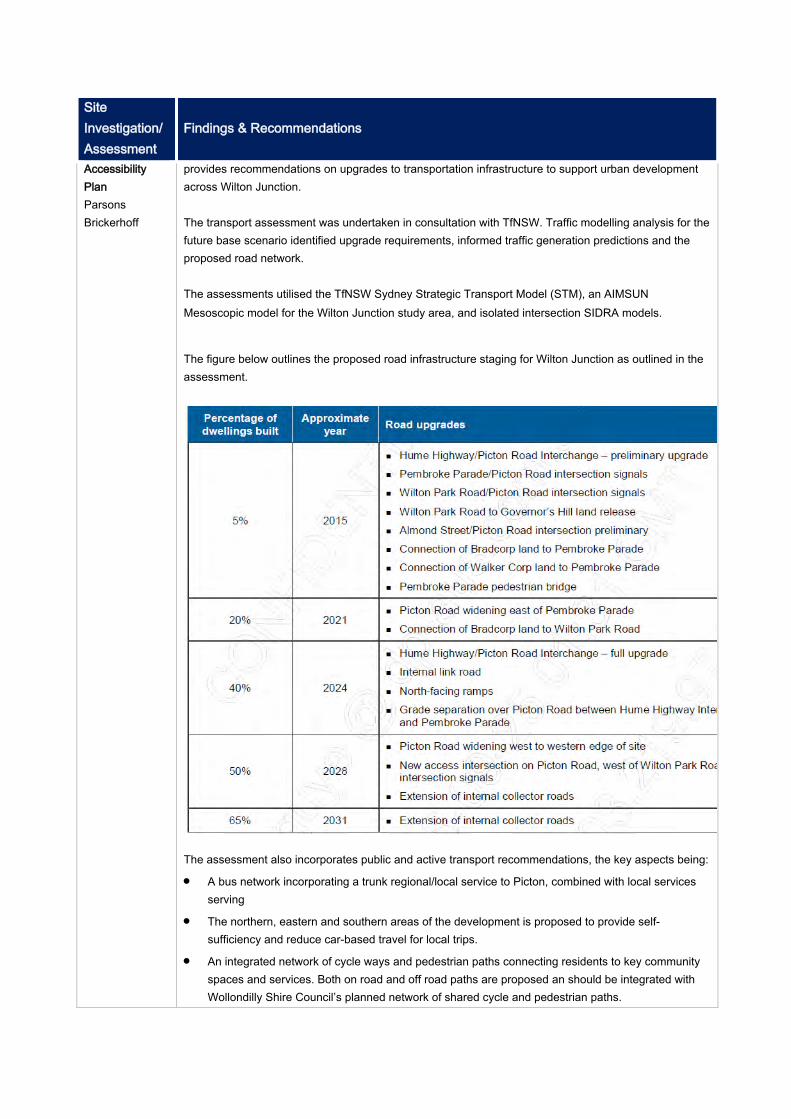
Site Investigation/ Assessment
Findings & Recommendations
Accessibility Plan Parsons Brickerhoff
provides recommendations on upgrades to transportation infrastructure to support urban development across Wilton Junction. The transport assessment was undertaken in consultation with TfNSW. Traffic modelling analysis for the future base scenario identified upgrade requirements, informed traffic generation predictions and the proposed road network. The assessments utilised the TfNSW Sydney Strategic Transport Model (STM), an AIMSUN Mesoscopic model for the Wilton Junction study area, and isolated intersection SIDRA models.
The figure below outlines the proposed road infrastructure staging for Wilton Junction as outlined in the assessment.
The assessment also incorporates public and active transport recommendations, the key aspects being: A bus network incorporating a trunk regional/local service to Picton, combined with local services
serving The northern, eastern and southern areas of the development is proposed to provide self-
sufficiency and reduce car-based travel for local trips. An integrated network of cycle ways and pedestrian paths connecting residents to key community
spaces and services. Both on road and off road paths are proposed an should be integrated with Wollondilly Shire Council’s planned network of shared cycle and pedestrian paths.
Site Investigation/ Assessment
Findings & Recommendations
Visual Analysis Report Connor Holmes
A Visual Analysis was undertaken by Conner Holmes which identified key viewscapes from the site and included recommendations for the urban design process: Key viewscapes from the site as identified in the report are: External views to the Razorback Mountains, the Southern Highlands, to the west to Maldon and to
the east to distant industry and St Mary’s Towers. These views are gained from high points along the southern boundary, the ridgeline south-west of Picton Road and the hills and ridge approximately halfway between the entry to the site from the north and the interchange along the Hume Highway.
Internal views are available across the Hume Highway to the golf course from high points and ridges to the west of the Hume Highway and the east of Picton Road.
Key stands of vegetation. Key internal features such as the golf course, the proposed lake, and potentially key buildings. The internal view sheds. Key ridge lines, hills and other vantage points.
The key recommendations as identified in the report are: Where possible and practicable key ridgelines and hills should be retained as open areas. This
could be in the form of public open space and/or incorporated into larger allotments in private ownership. These could be used as look out points to take advantage of, in particular, the external view sheds. This will also provide a green backdrop for residents and will provide interesting views from other elevated spots within the site.
The potential exists to link the key lookout points as part of a connected network of open space/ walking trails that will also provide for improved access throughout the locality.
Major features could be located to be visible from key vantage points. Where possible and practicable development should be kept below the key ridgelines. Roads are
appropriate in these areas. Where possible and practicable slopes should be used to maximise the opportunity for views and
development designed in sloping areas to maximise internal and external views from all dwellings.
Waste Management Strategy Eco-Sustainable
The Waste Strategy prepared by Eco-Sustainable provides strategic consideration of waste impacts to assist in minimising the generation of waste and maximising the recovery of resources. The report splits the management of waste for the project into three principal phases – Land Clearing and Civil Works, Construction and ongoing use. Some of the key measures from each phase are provided below: Land Clearing and Civil Works Prevent illegal dumping through robust notification of landfill areas and disposal processes. Street sweeping - Blend with local Sewage Treatment Plant (STP) wastes for composting and
approved land application.
Site Investigation/ Assessment
Findings & Recommendations
Bio-filtration of stormwater runoff Use of removed trees in water bio-filtration systems Road and footpath Construction - Reuse coal wash that meets government waste exemption
specifications in road works, and crushed waste glass bedding under footpath areas in place of sand.
Topsoil and vegetation - Reuse topsoil in place of silt fencing as an erosion control measure in sediment berms, as a compost blanket and in embankment stabilisation.
Remnant site materials - Existing fencing and outbuildings deconstructed for future recycling and reuse.
Construction Littering - Energy from Waste (EfW), Mixed Waste Processing. Illegal Dumping - Separation to recover recyclables such as brick, tile, concrete, rubble, metal and
timber. Disposal of residuals to landfill. Building waste (brick, tile, PVC etc) separated into skips for recycling. Topsoil and vegetation - Reuse material to enhance site soil as a mulch especially in shallow soil
profile areas, or as input to filtration media for rain gardens.
Ongoing Use Littering - Energy from Waste (EfW), Mixed Waste Processing. Street sweeping - Blend with local Sewage Treatment Plant (STP) wastes for composting and
approved land application. Other Strategies generally involve best case methods for disposing of residential and commercial
wastes including: mixed waste, dry recyclables, garden organics, bulky waste. The report also provides specific recommendations for road design to facilitate efficient waste collection. These are: Avoiding one-way streets and cul-de-sacs to facilitate safe access for collection vehicles and bin
servicing, Safe bin access and collection in the town centre area for commercial and mixed
commercial/residential buildings, Selection of street tree species such as non-deciduous varieties to minimise leaf litter, Traffic calming devices and the like should be fully accessible by street sweeping vehicles, and
their location should ideally be clear of bin collection zones. Wastewater Strategy MWH
MWH have developed a wastewater strategy for Wilton Junction based on the estimated 11,900 additional dwellings and 11,000 jobs to be delivered as part of the project. The Department of Planning and Environment, as part of the SR requirements in relation to wastewater management, recommended the following be delivered in for the Wilton Junction project: A Membrane Bio-Reactor (MBR) wastewater treatment plant with tertiary media filters located near
the existing Bingara Gorge STP. A pressure sewer network with individual pots and pumps installed on each property.
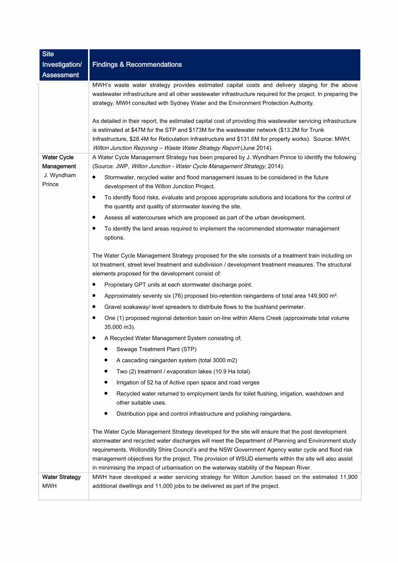
Site Investigation/ Assessment
Findings & Recommendations
MWH’s waste water strategy provides estimated capital costs and delivery staging for the above wastewater infrastructure and all other wastewater infrastructure required for the project. In preparing the strategy, MWH consulted with Sydney Water and the Environment Protection Authority. As detailed in their report, the estimated capital cost of providing this wastewater servicing infrastructure is estimated at $47M for the STP and $173M for the wastewater network ($13.2M for Trunk Infrastructure, $28.4M for Reticulation Infrastructure and $131.6M for property works). Source: MWH, Wilton Junction Rezoning – Waste Water Strategy Report (June 2014).
Water Cycle Management J. Wyndham Prince
A Water Cycle Management Strategy has been prepared by J. Wyndham Prince to identify the following (Source: JWP, Wilton Junction - Water Cycle Management Strategy, 2014): Stormwater, recycled water and flood management issues to be considered in the future
development of the Wilton Junction Project. To identify flood risks, evaluate and propose appropriate solutions and locations for the control of
the quantity and quality of stormwater leaving the site. Assess all watercourses which are proposed as part of the urban development. To identify the land areas required to implement the recommended stormwater management
options.
The Water Cycle Management Strategy proposed for the site consists of a treatment train including on lot treatment, street level treatment and subdivision / development treatment measures. The structural elements proposed for the development consist of: Proprietary GPT units at each stormwater discharge point. Approximately seventy six (76) proposed bio-retention raingardens of total area 149,900 m². Gravel soakaway/ level spreaders to distribute flows to the bushland perimeter. One (1) proposed regional detention basin on-line within Allens Creek (approximate total volume
35,000 m3). A Recycled Water Management System consisting of;
Sewage Treatment Plant (STP) A cascading raingarden system (total 3000 m2) Two (2) treatment / evaporation lakes (10.9 Ha total). Irrigation of 52 ha of Active open space and road verges Recycled water returned to employment lands for toilet flushing, irrigation, washdown and
other suitable uses. Distribution pipe and control infrastructure and polishing raingardens.
The Water Cycle Management Strategy developed for the site will ensure that the post development stormwater and recycled water discharges will meet the Department of Planning and Environment study requirements, Wollondilly Shire Council’s and the NSW Government Agency water cycle and flood risk management objectives for the project. The provision of WSUD elements within the site will also assist in minimising the impact of urbanisation on the waterway stability of the Nepean River.
Water Strategy MWH
MWH have developed a water servicing strategy for Wilton Junction based on the estimated 11,900 additional dwellings and 11,000 jobs to be delivered as part of the project.
Site Investigation/ Assessment
Findings & Recommendations
In developing the strategy, MWH engaged Sydney Water to establish the assessment criteria and approach of the report. The water servicing strategy for the proposed Wilton Junction development includes: Water supply from the Macarthur Water Filtration Plant. Amplified pumping station WP302 located at the Macarthur Water Filtration Plant. Construction of 6.5 km of DN600/500/450 trunk main generally along Wilton Road. A new pipe crossing of Broughtons Pass Gorge. Construction of 2 x 6 ML reservoirs located south of Picton Road. Construction of 11 km of DN500-200 distribution pipework MWH outline that the estimated capital cost of providing the trunk water servicing infrastructure is $18.9 million excluding reticulation pipework costs. This was based on the rates provided by VKL Consulting Ltd. It also assumes that the crossing of Broughtons Pass Gorge is by horizontal directional drilling which is about $4M cheaper than a new pipe bridge adjacent to the Cataract Bridge (Source: MWH, Wilton Junction Rezoning – Water Strategy (June 2014)).
State Infrastructure Servicing and Staging Plan Elton Consulting
Elton Consulting have summarised the Infrastructure Servicing and Staging Plan for Wilton Junction and outlined the Proponents Funding Offer in relation to the scope, cost, funding and delivery of the infrastructure required at Wilton Junction. The strategy has been prepared in consultation with all relevant infrastructure agencies of Government and Wollondilly Shire Council and addresses the former Director General of Planning and Infrastructure’s Key Study Requirements for the rezoning process. The estimated cost to provide all required infrastructure (roads, potable water, waste water, electricity and social infrastructure) triggered by Wilton Junction is $253,384,738. Of this amount: The State Infrastructure items of roads, public transport and social facilities comprise
$133,492,476, and Water, waste water and utility services amounts to $119,892,262 which will be covered by the
Proponents through commercial agreements with service providers. The Funding Offer to NSW Government is based on the premise that Wilton Junction infrastructure will be delivered at “no additional cost to Government”. The demand for infrastructure generated by Wilton Junction will be funded by those Wilton Junction landowners within the Study Area who benefit from the rezoning. There may be other infrastructure costs associated with the broader region that will form part of Government’s current or future capital program. As outlined by Elton, the Funding Offer incorporates the following aspects (Source: Elton Consulting, Wilton Junction New Town, SEPP Rezoning, Infrastructure Proposal to the NSW Government, 2014) Wilton Junction Landowners will fund the total infrastructure triggered by the Wilton Junction
development. Based on strategic cost estimates the scope of infrastructure to be funded amounts to $133,492,476 in today’s dollars.
The State Infrastructure items to be funded are:
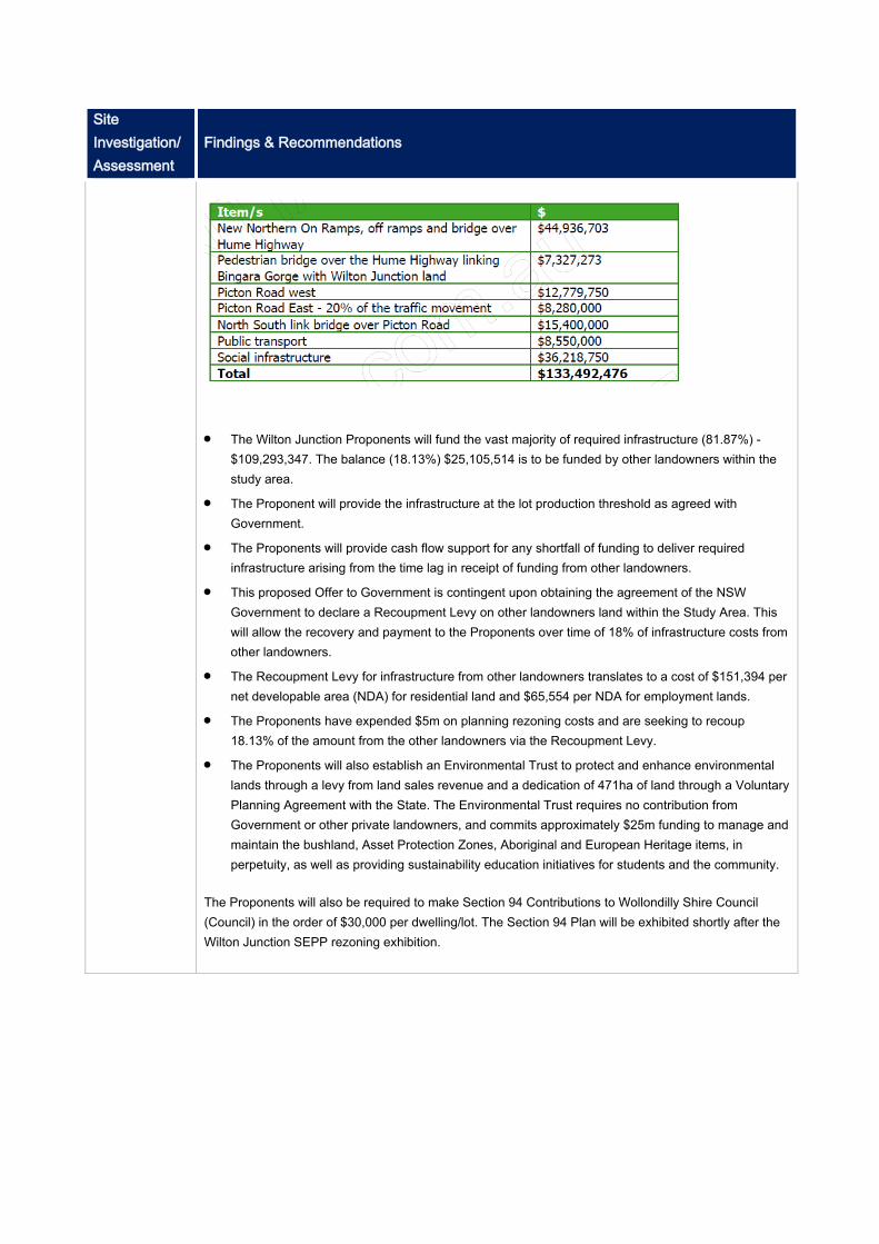
Site Investigation/ Assessment
Findings & Recommendations
The Wilton Junction Proponents will fund the vast majority of required infrastructure (81.87%) -
$109,293,347. The balance (18.13%) $25,105,514 is to be funded by other landowners within the study area.
The Proponent will provide the infrastructure at the lot production threshold as agreed with Government.
The Proponents will provide cash flow support for any shortfall of funding to deliver required infrastructure arising from the time lag in receipt of funding from other landowners.
This proposed Offer to Government is contingent upon obtaining the agreement of the NSW Government to declare a Recoupment Levy on other landowners land within the Study Area. This will allow the recovery and payment to the Proponents over time of 18% of infrastructure costs from other landowners.
The Recoupment Levy for infrastructure from other landowners translates to a cost of $151,394 per net developable area (NDA) for residential land and $65,554 per NDA for employment lands.
The Proponents have expended $5m on planning rezoning costs and are seeking to recoup 18.13% of the amount from the other landowners via the Recoupment Levy.
The Proponents will also establish an Environmental Trust to protect and enhance environmental lands through a levy from land sales revenue and a dedication of 471ha of land through a Voluntary Planning Agreement with the State. The Environmental Trust requires no contribution from Government or other private landowners, and commits approximately $25m funding to manage and maintain the bushland, Asset Protection Zones, Aboriginal and European Heritage items, in perpetuity, as well as providing sustainability education initiatives for students and the community.
The Proponents will also be required to make Section 94 Contributions to Wollondilly Shire Council (Council) in the order of $30,000 per dwelling/lot. The Section 94 Plan will be exhibited shortly after the Wilton Junction SEPP rezoning exhibition.

APPENDIX 6
Letter from Roads & Maritime Services dated 6 May 2016
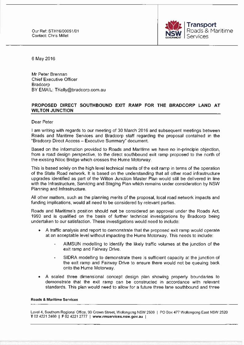
Are
NI-SW GOVERNMENT
Our Ref: STH16/00051/01 Contact: Chris Millet
Transport Roads & Maritime Services
6 May 2016
Mr Peter Brennan Chief Executive Officer Bradcorp BY EMAIL: [email protected]
PROPOSED DIRECT SOUTHBOUND EXIT RAMP FOR THE BRADCORP LAND AT WILTON JUNCTION
Dear Peter
I am writing with regards to our meeting of 30 March 2016 and subsequent meetings between Roads and Maritime Services and Bradcorp staff regarding the proposal contained in the "Bradcorp Direct Access — Executive Summary" document.
Based on the information provided to Roads and Maritime we have no in-principle objection, from a road design perspective, to the direct southbound exit ramp proposed to the north of the existing Niloc Bridge which crosses the Hume Motorway.
This is based solely on the high level technical merits of the exit ramp in terms of the operation of the State Road network. It is based on the understanding that all other road infrastructure upgrades identified as part of the Wilton Junction Master Plan would still be delivered in line with the Infrastructure, Servicing and Staging Plan which remains under consideration by NSW Planning and Infrastructure.
All other matters, such as the planning merits of the proposal, local road network impacts and funding implications, would all need to be considered by relevant parties.
Roads and Maritime's position should not be considered an approval under the Roads Act, 1993 and is qualified on the basis of further technical investigations by Bradcorp being undertaken to our satisfaction. These investigations would need to include:
• A traffic analysis and report to demonstrate that the proposed exit ramp would operate at an acceptable level without impacting the Hume Motorway. This needs to include:
- AIMSUN modelling to identify the likely traffic volumes at the junction of the exit ramp and Fairway Drive.
- SIDRA modelling to demonstrate there is sufficient capacity at the junction of the exit ramp and Fairway Drive to ensure there would not be queuing back onto the Hume Motorway.
• A scaled three dimensional concept design plan showing property boundaries to demonstrate that the exit ramp can be constructed in accordance with relevant standards. This plan would need to allow for a future three lane southbound and three
Roads & Maritime Services
Level 4, Southern Regional Office, 90 Crown Street, Wollongong NSW 2500 I PO Box 477 Wollongong East NSW 2520 1 02 4221 2460 I F 02 4221 2777 I www.rmservices.nsw.gov.au
Yours faithfully
lane northbound configuration on the Hume Motorway and needs to show the proposed long term treatment at the junction of the exit ramp and Fairway Drive.
• Whilst separate to this specific proposal, it should be noted Roads and Maritime requires similar concept design plans for the other entry and exit ramps proposed to connect to the Hume Motorway. It should be noted that Roads and Maritime does not support the proposed arrangements shown for the other southbound exit ramps. These exit ramps need to be combined into a single exit ramp, with a subsequent deceleration lane created off that ramp to provide access to Wilton Township.
• A revised signposting plan which incorporates the other southbound exit ramps into a single exit ramp. The signposting plan needs to detail the distance between the proposed exit ramp to Fairway Drive and the combined exit ramp to Wilton Township/Picton Road.
• A structural assessment of the Niloc Bridge to demonstrate the bridge is capable of accommodating the predicted future traffic loadings.
If you have any questions please contact Chris Millet on 4221 2570.
Michael Cush /General Manager
Network NSW
CC
Mark Ozinga, Transport for NSW ([email protected])

APPENDIX 7
Letter from NSW EPA dated 6 December 2013

Suite 801, 171 Clarence Street
SYDNEY NSW 2000
PO Box 1778 SYDNEY NSW 2001