Embed Size (px)
Citation preview

This document is designed to be read by the main stakeholder communities: the windenergy industry; and those responsible for aviation interests, broken down into safety offlight, air traffic management and air defence. Consequently, it is structured to allowreaders to quickly identify information pertinent to each interest group.

WIND ENERGY ANDAVIATION INTERESTS –
INTERIM GUIDELINES
WIND ENERGY,
DEFENCE & CIVIL AVIATION
INTERESTS WORKING GROUP
© Crown Copyright 2002
ETSU W/14/00626/REP

WIND ENERGY AND AVIATION INTERESTS – INTERIM GUIDELINES
i
FOREWORD BY BRIAN WILSON MP,
MINISTER FOR ENERGY AND CONSTRUCTION
DEPARTMENT OF TRADE AND INDUSTRY
Harnessing the UK’s wind resources is crucially important in meeting the Government’stargets for renewable energy and in tackling climate change. My Department is fullycommitted to encouraging the rapid development of the wind energy industry. However,such development must take place in a way which takes full account of national defence andair safety. It is important that the wind energy and aviation communities understand theneeds of the other and the purpose of these guidelines is to foster a better informed dialogue.In particular the guidelines explain the potential impact of wind turbines on radar systemsand the process for ensuring that wind farms are located where they do not give rise toinsuperable difficulties. I very much welcome their publication and commend them to windenergy developers and others with an interest as essential reading.
Foreword
Department of Trade and Industry
FOREWORD BY Dr LEWIS MOONIE MP,
PARLIAMENTARY UNDER SECRETARY OF STATE
FOR DEFENCE AND MINISTER FOR VETERANS
The Government has a target to achieve 10 per cent of the United Kingdom’s energy fromgreen sources by 2010 which my Department fully supports, and makes every effort to assistin achieving this. It is true to say however, that the Ministry of Defence does have a numberof safety concerns over the effects of wind turbines on radar and low flying. Whilst effortsmust continue to maintain flight safety and optimum radar coverage throughout the UnitedKingdom, we await the findings of a number of studies into these problems, and DefenceEstates will continue to assist developers by evaluating wind farm planning proposals on acase by case basis.
I believe these guidelines are a welcome addition to both setting out my Department’s andthe Government’s position and will greatly assist all involved in the Wind Energy industry.

WIND ENERGY AND AVIATION INTERESTS – INTERIM GUIDELINES
ii
FOREWORD BY SIR ROY McNULTY,
CHAIRMAN, CAA
The publication of this document is an important milestone in ensuring that all thoseinvolved in renewable energy and aviation have a better understanding of issues of mutualinterest. It is vital that the many different parties involved work closely together to ensurethat progress towards delivering national objectives can be achieved in a co-operative andconsistent way. This publication is evidence of work towards this goal and ourunderstanding will continue to evolve as the necessary research is completed. Safety cannotbe compromised, but it is imperative that all the parties involved in these issues canparticipate in an informed process which seeks solutions rather than confrontation.
FOREWORD BY DAVID STILL, CHAIRMAN,
BRITISH WIND ENERGY ASSOCIATION
The BWEA and its members consider safety of the utmost importance during thedevelopment and operation of wind farms. We work in partnership with Government andthe aviation communities to ensure that the delivery of clean, green electricity does notcause any adverse effects to national defence or air safety. To achieve this, we all need tounderstand the issues and make informed decisions. These new guidelines are a significantstep forward in ensuring that the best information is widely available. In working to theseguidelines, we ensure that we will achieve renewable energy targets safely, speedily and tothe highest possible standards.
WIND ENERGY AND AVIATION INTERESTS – INTERIM GUIDELINES
iii
Contents 1
2
3
4
5
6
Page
1 INTRODUCTION .......................................................................................................... 1
1.1 GENERAL.............................................................................................................. 11.2 AIM AND SCOPE.................................................................................................. 1
2 THE NEED FOR WIND ENERGY............................................................................... 3
2.1 INTRODUCTION.................................................................................................. 32.2 UK ENERGY POLICY IN THE GLOBAL CONTEXT ............................................. 32.3 THE RENEWABLES OBLIGATION ........................................................................ 42.4 THE POTENTIAL FOR RENEWABLE ENERGY ..................................................... 42.5 PROSPECTS FOR WIND ENERGY POST-2010 ..................................................... 52.6 WIND ENERGY – CONCLUSION ........................................................................ 6
3 AVIATION INTERESTS................................................................................................ 7
3.1 GENERAL.............................................................................................................. 73.2 SAFEGUARDING OF AVIATION INTERESTS........................................................ 73.3 VERTICAL OBSTRUCTIONS AND AERODROMES .............................................. 93.4 VERTICAL OBSTRUCTIONS AND LOW FLYING .............................................. 113.5 SAFEGUARDING OF TECHNICAL SITES (INCLUDING RADAR) ...................... 143.6 AVIATION INTERESTS – CONCLUSION............................................................ 20
4 THE PLANNING AND CONSULTATION PROCESSES .......................................... 21
4.1 THE PRE-PLANNING CONSULTATION PROCESS............................................. 214.2 THE PLANNING PROCESS ................................................................................. 26
5 CONCLUSION .............................................................................................................. 29
6 ANNEXES ..................................................................................................................... 30
ANNEX A BACKGROUND TO THE GUIDELINES ................................................... 31ANNEX B WIND POWER......................................................................................... 32ANNEX C SAFEGUARDED SITES – LISTS AND MAPS ............................................. 36ANNEX D RADAR SYSTEMS AND THE EFFECTS OF WIND TURBINES.................. 38ANNEX E PRE-PLANNING CONSULTATION FORM............................................... 43ANNEX F GLOSSARY ............................................................................................... 48ANNEX G LIST OF ACRONYMS............................................................................... 51ANNEX H CONTACT ADDRESSES ........................................................................... 53ANNEX I FEEDBACK PROFORMA .......................................................................... 55
INTRODUCTION
1
1.1 GENERAL
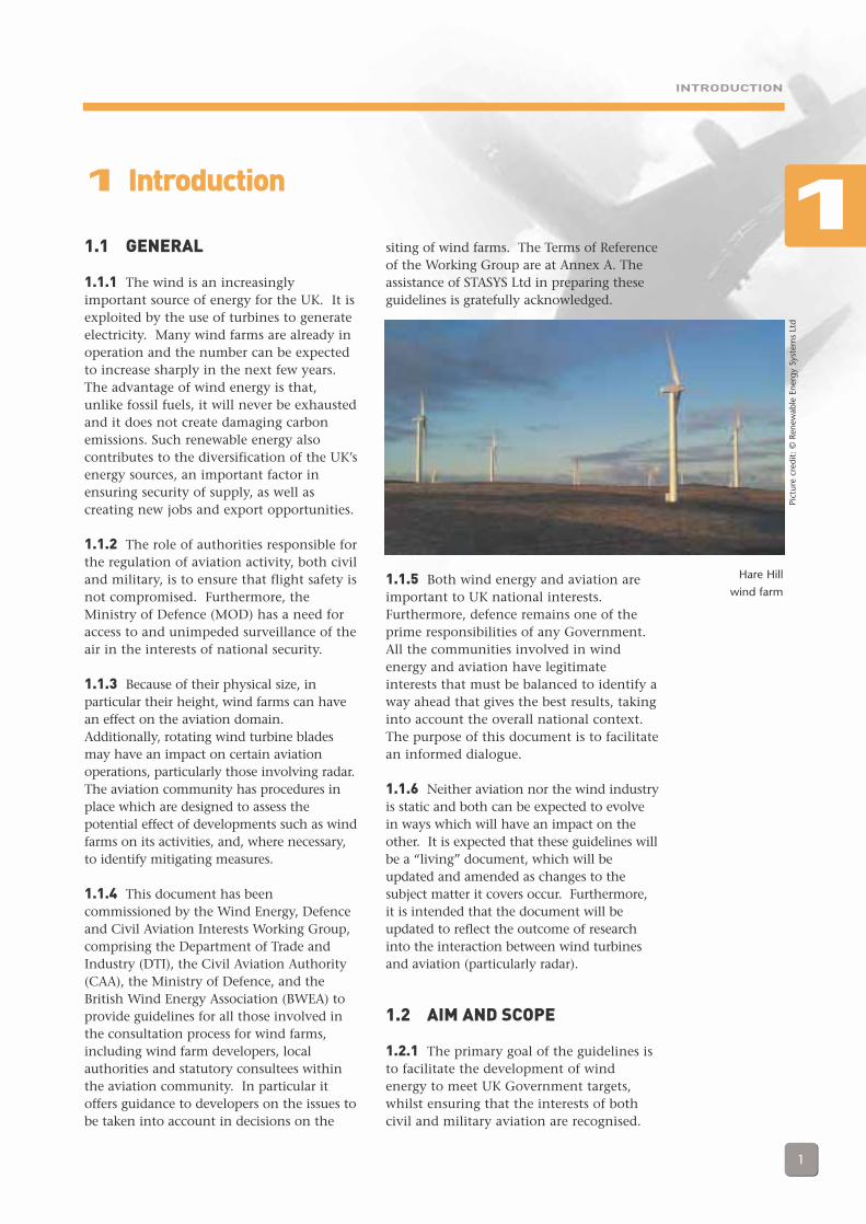
1.1.1 The wind is an increasinglyimportant source of energy for the UK. It isexploited by the use of turbines to generateelectricity. Many wind farms are already inoperation and the number can be expectedto increase sharply in the next few years.The advantage of wind energy is that,unlike fossil fuels, it will never be exhaustedand it does not create damaging carbonemissions. Such renewable energy alsocontributes to the diversification of the UK’senergy sources, an important factor inensuring security of supply, as well ascreating new jobs and export opportunities.
1.1.2 The role of authorities responsible forthe regulation of aviation activity, both civiland military, is to ensure that flight safety isnot compromised. Furthermore, theMinistry of Defence (MOD) has a need foraccess to and unimpeded surveillance of theair in the interests of national security.
1.1.3 Because of their physical size, inparticular their height, wind farms can havean effect on the aviation domain.Additionally, rotating wind turbine bladesmay have an impact on certain aviationoperations, particularly those involving radar.The aviation community has procedures inplace which are designed to assess thepotential effect of developments such as windfarms on its activities, and, where necessary,to identify mitigating measures.
1.1.4 This document has beencommissioned by the Wind Energy, Defenceand Civil Aviation Interests Working Group,comprising the Department of Trade andIndustry (DTI), the Civil Aviation Authority(CAA), the Ministry of Defence, and theBritish Wind Energy Association (BWEA) toprovide guidelines for all those involved inthe consultation process for wind farms,including wind farm developers, localauthorities and statutory consultees withinthe aviation community. In particular itoffers guidance to developers on the issues tobe taken into account in decisions on the
siting of wind farms. The Terms of Referenceof the Working Group are at Annex A. Theassistance of STASYS Ltd in preparing theseguidelines is gratefully acknowledged.
1.1.5 Both wind energy and aviation areimportant to UK national interests.Furthermore, defence remains one of theprime responsibilities of any Government.All the communities involved in windenergy and aviation have legitimateinterests that must be balanced to identify away ahead that gives the best results, takinginto account the overall national context.The purpose of this document is to facilitatean informed dialogue.
1.1.6 Neither aviation nor the wind industryis static and both can be expected to evolvein ways which will have an impact on theother. It is expected that these guidelines willbe a “living” document, which will beupdated and amended as changes to thesubject matter it covers occur. Furthermore,it is intended that the document will beupdated to reflect the outcome of researchinto the interaction between wind turbinesand aviation (particularly radar).
1.2 AIM AND SCOPE
1.2.1 The primary goal of the guidelines isto facilitate the development of windenergy to meet UK Government targets,whilst ensuring that the interests of bothcivil and military aviation are recognised.
1 Introduction
Hare Hill
wind farm
Pict
ure
cred
it: ©
Ren
ewab
le E
nerg
y Sy
stem
s Lt
d
1

INTRODUCTION
2
In particular, they aim to:
(a) Provide a clear, readable, singlesource of information on all aspectsof the impact of wind turbines onaviation, both civil and military.
(b) Identify the range of interactionsbetween wind energy and aviationinterests.
(c) Outline the measures adopted toaddress the issues which are likely toarise from such interactions.
(d) Identify the organisations involvedin these processes.
1.2.2 The document has been written for anumber of different audiences includingwind farm developers, local authorities andstatutory consultees, as well as others withan interest. Some sections will be morepertinent to certain stakeholders thanothers. Since the developer initiates theprocess to obtain planning consentemphasis is given to identifying his coursesof action in each case.
1.2.3 The document does not contain in-depth technical analysis but where suchanalysis has been conducted elsewhere, it isidentified and references given. Nor does itcover the issue of objections to wind farmproposals on economic grounds (such asfuture airport developments): suchobjections should be handled as part of thenormal planning process.
1.2.4 The guidelines will not be able tosolve all aviation-related problems butdevelopers who follow the guidance will bein a position to establish a dialogue withthe main interests concerned.
1.2.5 Further information on thebackground to the guidelines can be foundat Annex A.
Dun Law
wind farm
Pict
ure
cred
it: ©
Ren
ewab
le E
nerg
y Sy
stem
s Lt
d
1
THE NEED FOR WIND ENERGY
3
2.1 INTRODUCTION
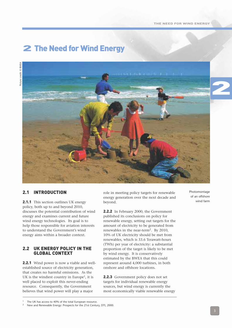
2.1.1 This section outlines UK energypolicy, both up to and beyond 2010,discusses the potential contribution of windenergy and examines current and futurewind energy technologies. Its goal is tohelp those responsible for aviation intereststo understand the Government’s windenergy aims within a broader context.
2.2 UK ENERGY POLICY IN THEGLOBAL CONTEXT
2.2.1 Wind power is now a viable and well-established source of electricity generation,that creates no harmful emissions. As theUK is the windiest country in Europe1, it iswell placed to exploit this never-endingresource. Consequently, the Governmentbelieves that wind power will play a major
2 The Need for Wind Energy
role in meeting policy targets for renewableenergy generation over the next decade andbeyond.
2.2.2 In February 2000, the Governmentpublished its conclusions on policy forrenewable energy, setting out targets for theamount of electricity to be generated fromrenewables in the near-term2. By 2010,10% of UK electricity should be met fromrenewables, which is 33.6 Terawatt-hours(TWh) per year of electricity: a substantialproportion of the target is likely to be metby wind energy. It is conservativelyestimated by the BWEA that this couldrepresent around 4,000 turbines, in bothonshore and offshore locations.
2.2.3 Government policy does not settargets for individual renewable energysources, but wind energy is currently themost economically viable renewable energy
1 The UK has access to 40% of the total European resource.2 New and Renewable Energy: Prospects for the 21st Century, DTI, 2000.
2
Photomontage
of an offshore
wind farm
Pict
ure
cred
it: ©
BW
EA
THE NEED FOR WIND ENERGY
4
source and therefore may be expected tomake the largest contribution.
2.3 THE RENEWABLESOBLIGATION
2.3.1 The Government has recentlyintroduced the Renewables Obligation withthe aim of increasing the amount ofelectricity generated in Great Britain fromrenewables sources, thus contributing to areduction in greenhouse gas emissions.The Renewables Obligation (and theassociated Renewables Obligation(Scotland)), which came into force on 1April 2002 requires that suppliers derive aspecified and increasing proportion of theelectricity they supply to customers fromeligible renewables. The RenewablesObligation will create extra demand forrenewable energy worth £1 billion by 2010.
2.3.2 The initial proportion of electricitygenerated from renewables is proposed tobe 3% in the first period (2002-3), risingannually to over 10% in 2010-11. TheObligation will then remain at leastconstant after 2010, but may well beincreased. It will not be reduced.
2.4 THE POTENTIAL FORRENEWABLE ENERGY
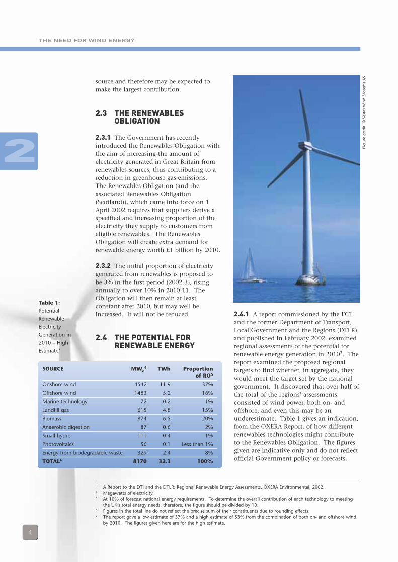
2.4.1 A report commissioned by the DTIand the former Department of Transport,Local Government and the Regions (DTLR),and published in February 2002, examinedregional assessments of the potential forrenewable energy generation in 20103. Thereport examined the proposed regionaltargets to find whether, in aggregate, theywould meet the target set by the nationalgovernment. It discovered that over half ofthe total of the regions’ assessmentsconsisted of wind power, both on- andoffshore, and even this may be anunderestimate. Table 1 gives an indication,from the OXERA Report, of how differentrenewables technologies might contributeto the Renewables Obligation. The figuresgiven are indicative only and do not reflectofficial Government policy or forecasts.
3 A Report to the DTI and the DTLR: Regional Renewable Energy Assessments, OXERA Environmental, 2002.4 Megawatts of electricity.5 At 10% of forecast national energy requirements. To determine the overall contribution of each technology to meeting
the UK’s total energy needs, therefore, the figure should be divided by 10.6 Figures in the total line do not reflect the precise sum of their constituents due to rounding effects.7 The report gave a low estimate of 37% and a high estimate of 53% from the combination of both on- and offshore wind
by 2010. The figures given here are for the high estimate.
2
SOURCE MWe4 TWh Proportion
of RO5
Onshore wind 4542 11.9 37%
Offshore wind 1483 5.2 16%
Marine technology 72 0.2 1%
Landfill gas 615 4.8 15%
Biomass 874 6.5 20%
Anaerobic digestion 87 0.6 2%
Small hydro 111 0.4 1%
Photovoltaics 56 0.1 Less than 1%
Energy from biodegradable waste 329 2.4 8%
TOTAL6 8170 32.3 100%
Table 1:
Potential
Renewable
Electricity
Generation in
2010 – High
Estimate7
Pict
ure
cred
it: ©
Ves
tas
Win
d Sy
stem
s A
S
THE NEED FOR WIND ENERGY
5
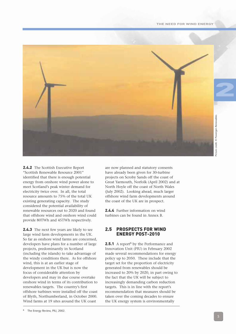
2.4.2 The Scottish Executive Report“Scottish Renewable Resource 2001”identified that there is enough potentialenergy from onshore wind power alone tomeet Scotland’s peak winter demand forelectricity twice over. In all, the totalresource amounts to 75% of the total UKexisting generating capacity. The studyconsidered the potential availability ofrenewable resources out to 2020 and foundthat offshore wind and onshore wind couldprovide 80TWh and 45TWh respectively.
2.4.3 The next few years are likely to seelarge wind farm developments in the UK.So far as onshore wind farms are concerned,developers have plans for a number of largeprojects, predominantly in Scotland(including the islands) to take advantage ofthe windy conditions there. As for offshorewind, this is at an earlier stage ofdevelopment in the UK but is now thefocus of considerable attention bydevelopers and may in due course overtakeonshore wind in terms of its contribution torenewables targets. The country’s firstoffshore turbines were installed off the coastof Blyth, Northumberland, in October 2000.Wind farms at 19 sites around the UK coast
are now planned and statutory consentshave already been given for 30-turbineprojects on Scroby Sands off the coast ofGreat Yarmouth, Norfolk (April 2002) and atNorth Hoyle off the coast of North Wales(July 2002). Looking ahead, much largeroffshore wind farm developments aroundthe coast of the UK are in prospect.
2.4.4 Further information on windturbines can be found in Annex B.
2.5 PROSPECTS FOR WINDENERGY POST-2010
2.5.1 A report8 by the Performance andInnovation Unit (PIU) in February 2002made several recommendations for energypolicy up to 2050. These include that thetarget set for the proportion of electricitygenerated from renewables should beincreased to 20% by 2020, in part owing tothe fact that the UK will be subject toincreasingly demanding carbon reductiontargets. This is in line with the report’srecommendation that measures should betaken over the coming decades to ensurethe UK energy system is environmentally
2
Pict
ure
cred
it: ©
Pow
erge
n Re
new
able
s
8 The Energy Review, PIU, 2002.
THE NEED FOR WIND ENERGY
6
sustainable and affords security of supply.A White Paper on Energy Policy will beproduced at the turn of the year and willinclude a Government response to the PIUReport. Also, it is likely that the ScottishExecutive will shortly issue a ConsultationPaper on whether increased renewableenergy generation targets should be set forthe period beyond 2010.
2.5.2 There is a likelihood that morestringent greenhouse gas targets will beadopted in the future and this will justifygiving environmental objectives highpriority within future energy policy. Windenergy is the most mature and economicallyviable renewable energy source and thus itfollows that the growing priority given torenewable electricity will mean growingpriority given to wind farm development.
2.6 WIND ENERGY -CONCLUSION
2.6.1 In summary, the Government iscommitted to reducing greenhouse gasemissions within the UK and this, in turn,means a shift towards economically viablerenewables. The impetus behind this shiftcan be expected to increase further after2010, as the UK is likely to become subjectto more stringent emission controls. It isimportant therefore that the aviationcommunity recognises the increasing rolewhich wind farms will play in the nationaleconomy and actively engages in theprocess of developing solutions to theconflicts of interest between wind energyand aviation operations.
2
AVIATION INTERESTS
7
3.1 GENERAL
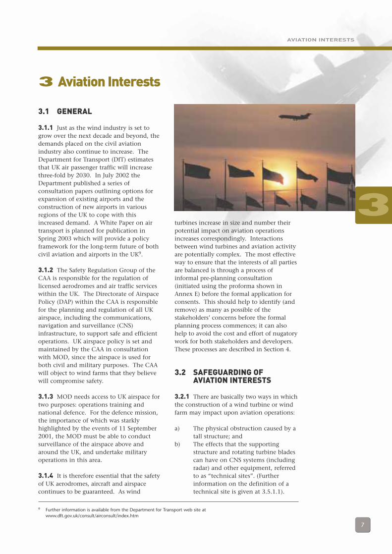
3.1.1 Just as the wind industry is set togrow over the next decade and beyond, thedemands placed on the civil aviationindustry also continue to increase. TheDepartment for Transport (DfT) estimatesthat UK air passenger traffic will increasethree-fold by 2030. In July 2002 theDepartment published a series ofconsultation papers outlining options forexpansion of existing airports and theconstruction of new airports in variousregions of the UK to cope with thisincreased demand. A White Paper on airtransport is planned for publication inSpring 2003 which will provide a policyframework for the long-term future of bothcivil aviation and airports in the UK9.
3.1.2 The Safety Regulation Group of theCAA is responsible for the regulation oflicensed aerodromes and air traffic serviceswithin the UK. The Directorate of AirspacePolicy (DAP) within the CAA is responsiblefor the planning and regulation of all UKairspace, including the communications,navigation and surveillance (CNS)infrastructure, to support safe and efficientoperations. UK airspace policy is set andmaintained by the CAA in consultationwith MOD, since the airspace is used forboth civil and military purposes. The CAAwill object to wind farms that they believewill compromise safety.
3.1.3 MOD needs access to UK airspace fortwo purposes: operations training andnational defence. For the defence mission,the importance of which was starklyhighlighted by the events of 11 September2001, the MOD must be able to conductsurveillance of the airspace above andaround the UK, and undertake militaryoperations in this area.
3.1.4 It is therefore essential that the safetyof UK aerodromes, aircraft and airspacecontinues to be guaranteed. As wind
turbines increase in size and number theirpotential impact on aviation operationsincreases correspondingly. Interactionsbetween wind turbines and aviation activityare potentially complex. The most effectiveway to ensure that the interests of all partiesare balanced is through a process ofinformal pre-planning consultation(initiated using the proforma shown inAnnex E) before the formal application forconsents. This should help to identify (andremove) as many as possible of thestakeholders’ concerns before the formalplanning process commences; it can alsohelp to avoid the cost and effort of nugatorywork for both stakeholders and developers.These processes are described in Section 4.
3.2 SAFEGUARDING OFAVIATION INTERESTS
3.2.1 There are basically two ways in whichthe construction of a wind turbine or windfarm may impact upon aviation operations:
a) The physical obstruction caused by atall structure; and
b) The effects that the supportingstructure and rotating turbine bladescan have on CNS systems (includingradar) and other equipment, referredto as “technical sites”. (Furtherinformation on the definition of atechnical site is given at 3.5.1.1).
3 Aviation Interests
9 Further information is available from the Department for Transport web site atwww.dft.gov.uk/consult/airconsult/index.htm
3
AVIATION INTERESTS
8
3.2.2 The stakeholders in both civil andmilitary aviation conduct a process known as“safeguarding”10 to ensure that their interestsare not compromised by development suchas wind farms. The objectives of thesafeguarding process are threefold:
a) to prevent the granting of planningpermission for developments whichwould impact upon the safe use ofaerodromes or CNS systems(including radar);
b) to ensure that the cumulative effects ofprevious and continuing developmentsare taken into account; and
c) to ensure that planning permission,where granted, is subject toappropriate conditions.
3.2.2.1 Safeguarding is the last stage atwhich proposals may be halted throughobjection from a stakeholder. Thevoluntary pre-planning consultation process(described in Section 4.1) is designed touncover and address any conflicts betweenaviation interests and wind energy beforethis stage is reached. Should newobjections arise at the formal safeguardingstage, it is highly unlikely that they will
prove to be easily, and inexpensively,resolved. This is but one reason forrecommending that developers establish anearly dialogue with aviation stakeholderswho may be affected by their plans.
3.2.2.2 The safeguarding process is alwayschanging due to new technologies andchanges in airspace structure and regulations,among other factors. The guidelines reflectcurrent processes and procedures.
3.2.2.3 Requirements for safeguardingaerodromes and technical sites are set out inGovernment documentation11. Theconsultation requirements in thedocumentation apply to military as well ascivil facilities. The process is based onsafeguarding maps that are lodged withlocal planning authorities (LPAs).
3.2.2.4 Under the current safeguardingprocess, LPAs consult the CAA about windfarm proposals that fall within areascovered by safeguarding maps. Owing to achange in the regulations12, with effectfrom September 2002, planning authoritieswill be required to consult the relevant civilaerodrome representative directly13. This isa relatively minor change and should betransparent to wind farm developers.
3.2.3 Safeguarding and Wind Turbines
3.2.3.1 Vertical Obstruction Safeguarding.Owing to their size, wind turbines areassessed as a vertical obstruction, as wouldany other tall structure, such as a largebuilding or mast. This is of particularrelevance in the vicinity of aerodromes (seeSection 3.3) and within the UK Low FlyingSystem (UKLFS) (see Section 3.4).
3.2.3.2 Technical Site Safeguarding. Anytall structure can potentially interfere withcertain electromagnetic transmissions;
10 The formal term Safeguarding in association with wind turbines is only used for civil purposes; military agencies do nothave an equivalent formal term but follow effectively the same procedures. For simplicity, the term safeguarding in thisdocument is used to refer to both civil and military processes.
11 Safeguarding Aerodromes, Technical Sites and Explosive Storage Areas: Town & Country Planning (Aerodromes andTechnical Sites) Direction 1992 (England & Wales) and Scottish Development Department Circular 16/1982, SafeguardingAerodromes, Technical Sites and Explosive Storage Areas. These documents are scheduled to be replaced in September2002 by the Department for Transport document Safeguarding Aerodromes, Technical Sites and Military ExplosivesStorage Areas: the Town and Country Planning (Safeguarded Aerodromes, Technical Sites and Military Explosives StorageAreas) Direction 2001.
12 This will occur when Direction 2001 comes into effect; see footnote 11.13 Military aerodromes may only be contacted through MOD and must under no circumstances be approached directly.
3
AVIATION INTERESTS
9
however, interactions are particularlycomplex in the case of rotating turbineblades. The impact on technical sites isassessed when a wind turbine or farm isproposed near an aerodrome that has a co-located technical site (for example,aerodrome approach radar); a stand-alonecivil technical site (for example, a NationalAir Traffic Services (NATS) en route radar);or on a stand-alone military technical site(for example, an air defence radar). This isdescribed further in Section 3.5.
3.2.3.3 Certain civil sites may contain aNATS en route radar (a technical site) andan aerodrome. If this is the case, separatesafeguarding maps will exist; both must beconsulted and individual consultationsmust take place with both NATS En-RouteLimited14 and the aerodrome operator.Where a military technical site is co-locatedwith a military aerodrome that is subject tosafeguarding, a single map exists.
3.2.3.4 There are currently 40 civilaerodromes and approximately 150 civiltechnical sites in the UK that are officiallysafeguarded as per the directions. However,
any aerodrome in the UK may wish tosafeguard itself and therefore be consulted.In addition, certain military aerodromes aresafeguarded, on the basis of their strategicimportance, together with a large number ofmilitary technical sites (see Annex C for listsof safeguarded aerodromes).
3.3 VERTICAL OBSTRUCTIONSAND AERODROMES
3.3.1 Safeguarding Maps forAerodromes
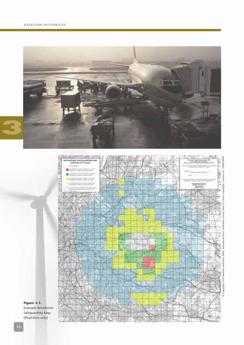
3.3.1.1 Each safeguarded aerodrome isissued with two safeguarding maps centredon the aerodrome. One map extends out toa radius of 15 km and is colour-coded toindicate the height above ground level forwhich any proposed developments must beconsulted. These coloured areas are basedloosely on a series of protected “surfaces”around the aerodrome15. The second mapextends out to a radius of 30 km: the LPA isrequired to consult the relevant aerodromeregarding any wind turbine proposal withinthis radius. Figure 3-1 shows an example ofan aerodrome safeguarding map.
3.3.1.2 It should be noted that this doesnot necessarily mean that an aerodromewill object to a proposal. Each proposal willbe assessed against the relevant protectedsurface. Only in the event of a penetrationof this surface will the aerodrome raise anobjection. However, if a developer hasconsulted the aerodrome operator at thevoluntary pre-planning consultation stage,such an issue should have already beenresolved.
3.3.1.3 It is not easy to summarise the idealpositioning of wind turbines in relation to ageneric ‘airfield’. All aerodromes vary dueto their size, their equipment fit and thenature of their operations, among otherfactors. As ever, early dialogue is the bestway to resolve any conflicts.
3.3.1.4 Technical site safeguarding, includingaerodromes, is covered in Section 3.5.
14 National Air Traffic Services Ltd is the parent company for a number of subsidiary operating and service provisioncompanies, including NATS En Route Ltd which is responsible for en-route radars.
15 These are described and detailed in Civil Aviation Publication (CAP) 168 (Licensing of Aerodromes).
3
AVIATION INTERESTS
10
Figure 3-1.
Example Aerodrome
Safeguarding Map
(Illustrative only)
3
© C
opyr
ight
Civ
il Av
iatio
n A
utho
rity
2002
, re
pro
duce
d fr
om O
rdna
nce
Surv
ey d
ata
© C
row
n co
pyr
ight
. Li
cenc
e no
. 10
0018
949
AVIATION INTERESTS
11
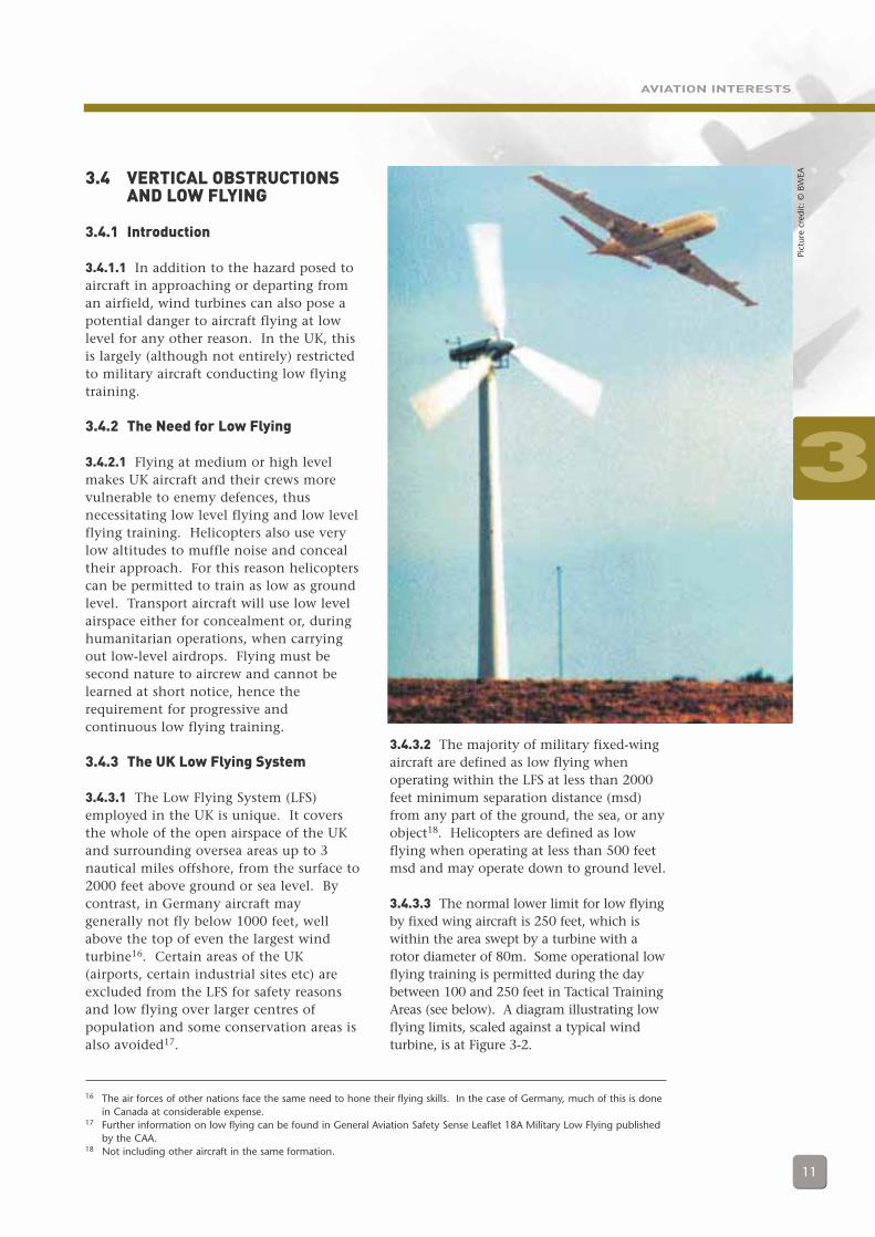
3.4 VERTICAL OBSTRUCTIONSAND LOW FLYING
3.4.1 Introduction
3.4.1.1 In addition to the hazard posed toaircraft in approaching or departing froman airfield, wind turbines can also pose apotential danger to aircraft flying at lowlevel for any other reason. In the UK, thisis largely (although not entirely) restrictedto military aircraft conducting low flyingtraining.
3.4.2 The Need for Low Flying
3.4.2.1 Flying at medium or high levelmakes UK aircraft and their crews morevulnerable to enemy defences, thusnecessitating low level flying and low levelflying training. Helicopters also use verylow altitudes to muffle noise and concealtheir approach. For this reason helicopterscan be permitted to train as low as groundlevel. Transport aircraft will use low levelairspace either for concealment or, duringhumanitarian operations, when carryingout low-level airdrops. Flying must besecond nature to aircrew and cannot belearned at short notice, hence therequirement for progressive andcontinuous low flying training.
3.4.3 The UK Low Flying System
3.4.3.1 The Low Flying System (LFS)employed in the UK is unique. It coversthe whole of the open airspace of the UKand surrounding oversea areas up to 3nautical miles offshore, from the surface to2000 feet above ground or sea level. Bycontrast, in Germany aircraft maygenerally not fly below 1000 feet, wellabove the top of even the largest windturbine16. Certain areas of the UK(airports, certain industrial sites etc) areexcluded from the LFS for safety reasonsand low flying over larger centres ofpopulation and some conservation areas isalso avoided17.
3.4.3.2 The majority of military fixed-wingaircraft are defined as low flying whenoperating within the LFS at less than 2000feet minimum separation distance (msd)from any part of the ground, the sea, or anyobject18. Helicopters are defined as lowflying when operating at less than 500 feetmsd and may operate down to ground level.
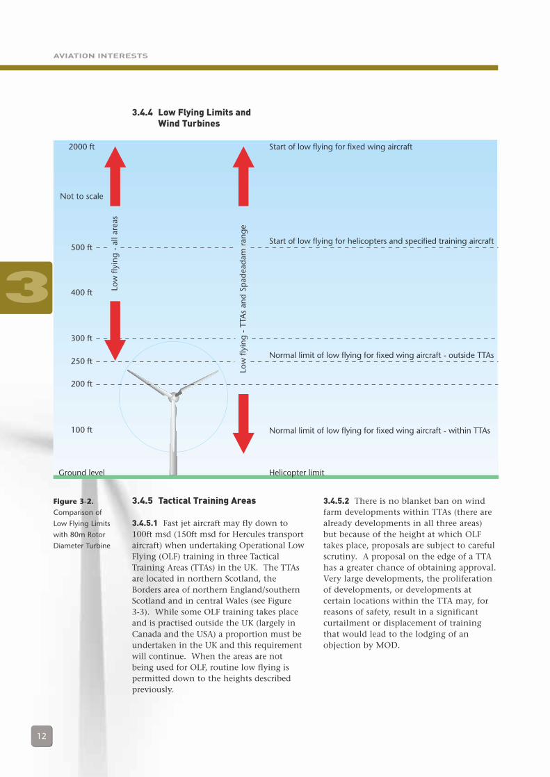
3.4.3.3 The normal lower limit for low flyingby fixed wing aircraft is 250 feet, which iswithin the area swept by a turbine with arotor diameter of 80m. Some operational lowflying training is permitted during the daybetween 100 and 250 feet in Tactical TrainingAreas (see below). A diagram illustrating lowflying limits, scaled against a typical windturbine, is at Figure 3-2.
16 The air forces of other nations face the same need to hone their flying skills. In the case of Germany, much of this is donein Canada at considerable expense.
17 Further information on low flying can be found in General Aviation Safety Sense Leaflet 18A Military Low Flying publishedby the CAA.
18 Not including other aircraft in the same formation.
3
Pict
ure
cred
it: ©
BW
EA
AVIATION INTERESTS
12
3.4.4 Low Flying Limits and Wind Turbines
3.4.5 Tactical Training Areas
3.4.5.1 Fast jet aircraft may fly down to100ft msd (150ft msd for Hercules transportaircraft) when undertaking Operational LowFlying (OLF) training in three TacticalTraining Areas (TTAs) in the UK. The TTAsare located in northern Scotland, theBorders area of northern England/southernScotland and in central Wales (see Figure 3-3). While some OLF training takes placeand is practised outside the UK (largely inCanada and the USA) a proportion must beundertaken in the UK and this requirementwill continue. When the areas are notbeing used for OLF, routine low flying ispermitted down to the heights describedpreviously.
3.4.5.2 There is no blanket ban on windfarm developments within TTAs (there arealready developments in all three areas)but because of the height at which OLFtakes place, proposals are subject to carefulscrutiny. A proposal on the edge of a TTAhas a greater chance of obtaining approval.Very large developments, the proliferationof developments, or developments atcertain locations within the TTA may, forreasons of safety, result in a significantcurtailment or displacement of trainingthat would lead to the lodging of anobjection by MOD.
3
2000 ft Start of low flying for fixed wing aircraft
Start of low flying for helicopters and specified training aircraft
Normal limit of low flying for fixed wing aircraft - outside TTAs
Normal limit of low flying for fixed wing aircraft - within TTAs
Helicopter limit
Not to scale
500 ft
400 ft
300 ft
250 ft
200 ft
100 ft
Ground level
Low
flyi
ng
- a
ll ar
eas
Low
flyi
ng
- T
TAs
and
Sp
adea
dam
ran
ge
Figure 3-2.
Comparison of
Low Flying Limits
with 80m Rotor
Diameter Turbine

AVIATION INTERESTS
3.4.6 Spadeadam Range
3.4.6.1 RAF Spadeadam is home to theElectronic Warfare Tactics Range (EWTR), afacility offering a range and quality ofelectronic warfare training unique in Europe.High energy and high speed tactical radaravoidance training involving simulated anti-aircraft missile firings, requiring the ability toundertake sudden evasive manoeuvres, takeplace down to 100ft msd in the training areaassociated with use of the Range. Inaddition, test and evaluation flying,specialised night flying and some OLF takeplace within the airspace, the majority ofwhich falls within TTA No 20T (see Figure 3-3). Other NATO countries use the facilitiesat Spadeadam on a repayment basis.
3.4.6.2 The Secretary of State for Trade andIndustry has previously denied permissionfor the construction of a wind farm withinthe range, reflecting the importance andunique nature of training that occurs there.There is no blanket ban on wind farms;each proposal will be considered on its ownmerits. However, it is likely that the MODwill object to a proposal to site a wind farmwithin the range. Developers consideringlocating a wind farm within the Spadeadamrange are advised to enter into dialoguewith the MOD, through Defence Estates, atthe earliest opportunity.
3
1
2
3
Tactical Training Areas1 - Area No. 14T2 - Area No. 20T3 - Area No. 7T
EW Tactics RangeSpadeadam
Figure 3-3.
Tactical Training
Areas and
Spadeadam Range
(Indicative only)
13
AVIATION INTERESTS
14
3.4.7 Low Flying Offshore
3.4.7.1 The LFS per se extends only 3nautical miles out to sea; however, bothmilitary and civilian aircraft routinely flydown to low levels over the sea, includingmilitary fast jets conducting training,surveillance aircraft engaged in fisheriesprotection, or helicopters conducting searchand rescue operations or en route tooilfields. Nevertheless, there is currently noformal low flying system over the sea whichis likely affect wind turbine developments.
3.4.7.2 Offshore wind farms, especiallydevelopments of considerable size, mayaffect operations such as those describedabove. However, the potential for conflictis likely to be resolved by effective chartingand appropriate lighting arrangements sothat aviators can avoid the development19.
3.4.7.3 Developers planning wind farmsoffshore are advised to follow the usual pre-planning consultation procedures (asdescribed in Section 4.1) and address anypotential conflicts with aviationstakeholders as soon as possible.
3.4.8 Conclusions
3.4.8.1 It is evident from existing windfarms that low flying aircraft and windturbines can co-exist and new developmentsshould not in principle give rise toobjections on the ground that theyrepresent a hazard to low flying aircraft.
MOD will review all applications on a caseby case basis, paying particular attention tocumulative effects. However, specialconsiderations apply in TTAs and theSpadeadam Range. Developers who areconsidering siting turbines in theselocations are strongly advised to discusstheir plans with MOD, through DefenceEstates, at the earliest opportunity.
3.5 SAFEGUARDING OFTECHNICAL SITES AND AERODROMES (INCLUDING RADAR)
3.5.1 General
3.5.1.1 The technical sites requiringsafeguarding fall into three basic categories:
a) Sites engaged in or supportingairspace and air traffic management(both civil and military), includingradars and navigation aids.
b) Sites engaged in or supporting the airdefence of the UK, including radars.
c) Meteorological (Met) Office weatherradars.
3.5.1.2 Consultation on safeguardingrequirements for civil technical sites isrequired within a 30km radius centred onthe aerodrome or technical site20. This is toreflect the fact that turbines can have effectson the electromagnetic spectrum inaddition to their physical presence. This30km radius is not a simple ‘yes/no’ line,however, but a working figure to signal thatconsultation is necessary. Depending uponthe nature of the technical site in question,plus other factors such as terrain, proposalswithin 30km may well receive no objectionwhilst those a considerable distance fromthe site may sometimes prove moreproblematic. Again, cumulative effects willbe taken into account.
3.5.1.3 The safeguarding of militarytechnical sites will be conducted on a caseby case basis, taking into account theindividual circumstances of the application.
19 Offshore wind farms must be marked with suitable Aircraft Warning Lights as described in ‘Lighting of Wind TurbineGenerators in United Kingdom Territorial Waters’ and in consultation with the Directorate of Airspace Policy within theCivil Aviation Authority.
20 It should be noted that this figure applies to civil sites only. Separate arrangements apply to military sites, including radars.
3
Pict
ure
cred
it: ©
GE
Win
d En
ergy
AVIATION INTERESTS
15
This is another reason why it isadvantageous for developers to enterconsultation with aviation stakeholders atthe earliest opportunity to improve thechances of resolving any issues raised.
3.5.2 Air Traffic ManagementConsiderations
3.5.2.1 General
3.5.2.1.1 The potential impacts of windfarms on air traffic management include thecumulative effects on the UK airspacemanagement and surveillance infrastructureand affect the following systems:
a) Primary Radar.b) Secondary Surveillance Radar (SSR).c) Microwave links associated with a)
and b).d) Navigation Aids (Navaids)21.
Background information on how thesesystems work and are used, together withthe effects of wind turbines and mitigationtechniques, is at Annex D. The remainderof this section concentrates on how thesystems above can be affected by windturbines and identifies, where known,mitigating measures that can be taken froma developer’s perspective. However, manyof the precise effects of wind turbines onthese systems are not yet fully understood22
and the guidance issued in this sectionmust therefore be considered as interim,based on the best knowledge currentlyavailable.
3.5.2.1.2 It should be borne in mind that itis not the effect that wind turbines have ontechnical systems in themselves that isimportant but the end effect that is causedto flight safety-critical air trafficmanagement operations. Hence, ifpragmatic solutions can be found (forexample, by replacing the service providedby an affected SSR with a suitably locatedreplacement SSR), these may offer a way
forward. On the other hand, if anaerodrome approach radar must be situatedin one particular location in order to ensuresafety of departing and arriving aircraft, anyproposal for wind turbines that will causedetrimental effects to the radar is unlikely tobe acceptable. The stakeholders identified inSection 4 will be able to advise developerson such issues at a very early stage.
3.5.2.2 Primary Radar
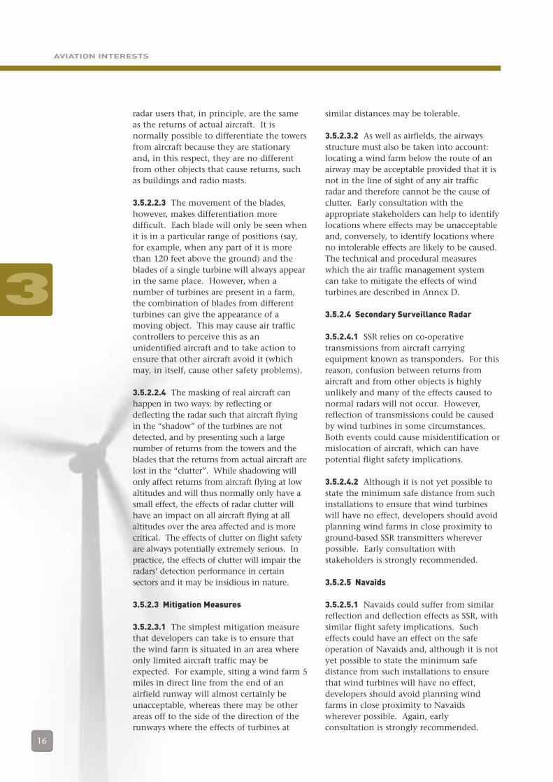
3.5.2.2.1 There aretwo basic effects thatcan be caused to airtraffic managementradars by windturbines: thepresentation of falseradar responses(known as returns), and the masking(shadowing) of genuine aircraft returns.Each causes different problems to the airtraffic management systems, and air trafficcontrollers in particular, but both may beamenable to mitigation in similar ways.
3.5.2.2.2 Both the towers and the blades ofwind turbines may be detected if they are inthe line of sight of the radar23. This willcause the presentation of returns to the
21 The effects of wind turbines on High Intensity Radio Transmission Areas (HIRTAs) have also been considered but arethought to be so minimal as not to be a safety issue and thus are not discussed here.
22 Studies into both the effects of wind turbines and possible technical mitigating measures are currently being undertaken.See Annex D, Section 5, for details.
23 The line of sight for a radar is usually equal to or greater than the optical line of sight. The radar line of sight is a complexfunction of the radar, the terrain and local weather conditions. A good approximation is that the radar line of sight is 33%greater than the optical line of sight. However, over the sea the difference can be much greater. Consultation withstakeholders can identify the actual line of sight for any particular radar.
3
Radar
Terrain
Turbines
Illuminationfrom radar
Shadowed region(parts of turbinenot illuminated)
Figure 3-4.
General geometry
of the problem –
terrain shadowing
Pict
ure
cred
it: ©
JAN
ES d
efen
ce p
ublic
atio
ns
Watchman
(normal ATC)
radar
AVIATION INTERESTS
16
radar users that, in principle, are the sameas the returns of actual aircraft. It isnormally possible to differentiate the towersfrom aircraft because they are stationaryand, in this respect, they are no differentfrom other objects that cause returns, suchas buildings and radio masts.
3.5.2.2.3 The movement of the blades,however, makes differentiation moredifficult. Each blade will only be seen whenit is in a particular range of positions (say,for example, when any part of it is morethan 120 feet above the ground) and theblades of a single turbine will always appearin the same place. However, when anumber of turbines are present in a farm,the combination of blades from differentturbines can give the appearance of amoving object. This may cause air trafficcontrollers to perceive this as anunidentified aircraft and to take action toensure that other aircraft avoid it (whichmay, in itself, cause other safety problems).
3.5.2.2.4 The masking of real aircraft canhappen in two ways: by reflecting ordeflecting the radar such that aircraft flyingin the “shadow” of the turbines are notdetected, and by presenting such a largenumber of returns from the towers and theblades that the returns from actual aircraft arelost in the “clutter”. While shadowing willonly affect returns from aircraft flying at lowaltitudes and will thus normally only have asmall effect, the effects of radar clutter willhave an impact on all aircraft flying at allaltitudes over the area affected and is morecritical. The effects of clutter on flight safetyare always potentially extremely serious. Inpractice, the effects of clutter will impair theradars’ detection performance in certainsectors and it may be insidious in nature.
3.5.2.3 Mitigation Measures
3.5.2.3.1 The simplest mitigation measurethat developers can take is to ensure thatthe wind farm is situated in an area whereonly limited aircraft traffic may beexpected. For example, siting a wind farm 5miles in direct line from the end of anairfield runway will almost certainly beunacceptable, whereas there may be otherareas off to the side of the direction of therunways where the effects of turbines at
similar distances may be tolerable.
3.5.2.3.2 As well as airfields, the airwaysstructure must also be taken into account:locating a wind farm below the route of anairway may be acceptable provided that it isnot in the line of sight of any air trafficradar and therefore cannot be the cause ofclutter. Early consultation with theappropriate stakeholders can help to identifylocations where effects may be unacceptableand, conversely, to identify locations whereno intolerable effects are likely to be caused.The technical and procedural measureswhich the air traffic management systemcan take to mitigate the effects of windturbines are described in Annex D.
3.5.2.4 Secondary Surveillance Radar
3.5.2.4.1 SSR relies on co-operativetransmissions from aircraft carryingequipment known as transponders. For thisreason, confusion between returns fromaircraft and from other objects is highlyunlikely and many of the effects caused tonormal radars will not occur. However,reflection of transmissions could be causedby wind turbines in some circumstances.Both events could cause misidentification ormislocation of aircraft, which can havepotential flight safety implications.
3.5.2.4.2 Although it is not yet possible tostate the minimum safe distance from suchinstallations to ensure that wind turbineswill have no effect, developers should avoidplanning wind farms in close proximity toground-based SSR transmitters whereverpossible. Early consultation withstakeholders is strongly recommended.
3.5.2.5 Navaids
3.5.2.5.1 Navaids could suffer from similarreflection and deflection effects as SSR, withsimilar flight safety implications. Sucheffects could have an effect on the safeoperation of Navaids and, although it is notyet possible to state the minimum safedistance from such installations to ensurethat wind turbines will have no effect,developers should avoid planning windfarms in close proximity to Navaidswherever possible. Again, earlyconsultation is strongly recommended.
3
AVIATION INTERESTS
17
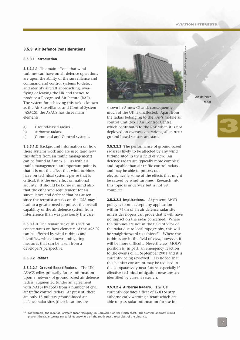
3.5.3 Air Defence Considerations
3.5.3.1 Introduction
3.5.3.1.1 The main effects that windturbines can have on air defence operationsare upon the ability of the surveillance andcommand and control systems to detectand identify aircraft approaching, over-flying or leaving the UK and thence toproduce a Recognised Air Picture (RAP).The system for achieving this task is knownas the Air Surveillance and Control System(ASACS); the ASACS has three mainelements:
a) Ground-based radars.b) Airborne radars.c) Command and Control systems.
3.5.3.1.2 Background information on howthese systems work and are used (and howthis differs from air traffic management)can be found at Annex D. As with airtraffic management, an important point isthat it is not the effect that wind turbineshave on technical systems per se that iscritical: it is the end effect on nationalsecurity. It should be borne in mind alsothat the enhanced requirement for airsurveillance and defence that has arisensince the terrorist attacks on the USA maylead to a greater need to protect the overallcapability of the air defence system frominterference than was previously the case.
3.5.3.1.3 The remainder of this sectionconcentrates on how elements of the ASACScan be affected by wind turbines andidentifies, where known, mitigatingmeasures that can be taken from adeveloper’s perspective.
3.5.3.2 Radars
3.5.3.2.1 Ground-Based Radars. The UKASACS relies primarily for its informationupon a network of ground-based air defenceradars, augmented (under an agreementwith NATS) by feeds from a number of civilair traffic control radars. At present, thereare only 13 military ground-based airdefence radar sites (their locations are
shown in Annex C) and, consequently,much of the UK is unaffected. Apart fromthe radars belonging to the RAF’s mobile aircontrol unit (No 1 Air Control Centre),which contributes to the RAP when it is notdeployed on overseas operations, all currentground-based sensors are static.
3.5.3.2.2 The performance of ground-basedradars is likely to be affected by any windturbine sited in their field of view. Airdefence radars are typically more complexand capable than air traffic control radarsand may be able to process outelectronically some of the effects that mightbe caused by wind turbines. Research intothis topic is underway but is not yetcomplete.
3.5.3.2.3 Implications. At present, MODpolicy is to not accept any applicationwithin 74km of an air defence radar siteunless developers can prove that it will haveno impact on the radar concerned. Wherethe turbines are not in the field of view ofthe radar due to local topography, this willbe straightforward to achieve24. Where theturbines are in the field of view, however, itwill be more difficult. Nevertheless, MOD’sposition is, in part, an emergency reactionto the events of 11 September 2001 and it iscurrently being reviewed. It is hoped thatthis blanket constraint may be reduced inthe comparatively near future, especially ifeffective technical mitigation measures areidentified by current research.
3.5.3.2.4 Airborne Radars. The UKcurrently operates a fleet of E-3D Sentryairborne early warning aircraft which areable to pass radar information for use in
24 For example, the radar at Portreath (near Newquay) in Cornwall is on the North coast. The Cornish landmass wouldprevent the radar seeing any turbines anywhere off the south coast, regardless of the distance.
3
Pict
ure
cred
it: ©
JAN
ES d
efen
ce p
ublic
atio
ns
Air defence
radar
AVIATION INTERESTS
18
compilation of the RAP. By their verynature, the E-3D’s radar and other sensorsare much less likely to be significantlyaffected by the presence of wind turbines.In the future, the RAF will bring theAirborne Stand-off Radar (ASTOR) airbornesystem into service, which will possess asophisticated suite of sensors, primarily forland surveillance. At present, it is notpossible to determine the potential effects awind turbine could have on this system,nor how these might affect defenceconsiderations. Other airborne radars,including those in fighter aircraft, can alsosee wind turbines but there is currently nofirm evidence of their effects on eitheroperational performance or flight safety25.
3.5.3.3 Command and Control Systems
3.5.3.3.1 The radar sensors around the UKproduce the raw data for compilation of theRAP; it is the role of the staff within theCommand and Control system actually toproduce the RAP and to direct responses toany activity which may warrant action. Theequipment within the UK ASACS Commandand Control centres consists of, inter alia,radar displays, tactical data link consoles andcommunications systems. Any detrimentaleffects produced by the presence of windturbines upon the ASACS sensors will behighly likely to have an impact at theCommand and Control centres. It is at thislevel, therefore, that the effects induced bywind turbines become critical. Developers(and others) conducting studies into theeffects of wind turbines on air defence musttherefore also consider the effects on theCommand and Control system; simplyconsidering the radar in isolation will notadequately address the issue. Indeed, it maybe that some effects that the radar itself isunable to compensate for can be adequatelyhandled by the processing elements of theCommand and Control system.
3.5.3.3.2 In addition to production of theRAP, certain staff within the ASACS areresponsible for the control of (primarily airdefence) aircraft. The considerations forcontrol of these aircraft are similar to thosefor air traffic management, as described inSection 3.5.2.
3.5.3.4 Mitigation Measures
3.5.3.4.1 Developers planning to locate awind farm within the vicinity of ASACSradar installations are strongly advised tocontact MOD as early as possible to discussthe implications of their proposals on airdefence operations, including theCommand and Control system, and toexplore possibilities for mitigating theeffects of turbines on the system. It is likelythat both the impact of the turbines andthe results of mitigation techniques willvary depending on the particular radar inquestion and the location andcharacteristics of the wind farm.
3.5.3.4.2 As the effects on air defence radar(and radar in general) are highly complexand are not yet completely understooddevelopers are strongly advised to seekexpert advice to inform their discussionswith MOD. Early indications from currentresearch (see Annex D for furtherinformation on current studies) are that avariety of mitigation techniques may be ofuse either individually or in combination.Possible mitigation measures includemoving the location of the wind farm oradjusting the configuration of the turbines.For larger wind farms, as a last resort, itmight be possible to overcome MODobjections by providing an alternativelocation for the affected radar orcontributing to investment in additional orimproved radar systems.
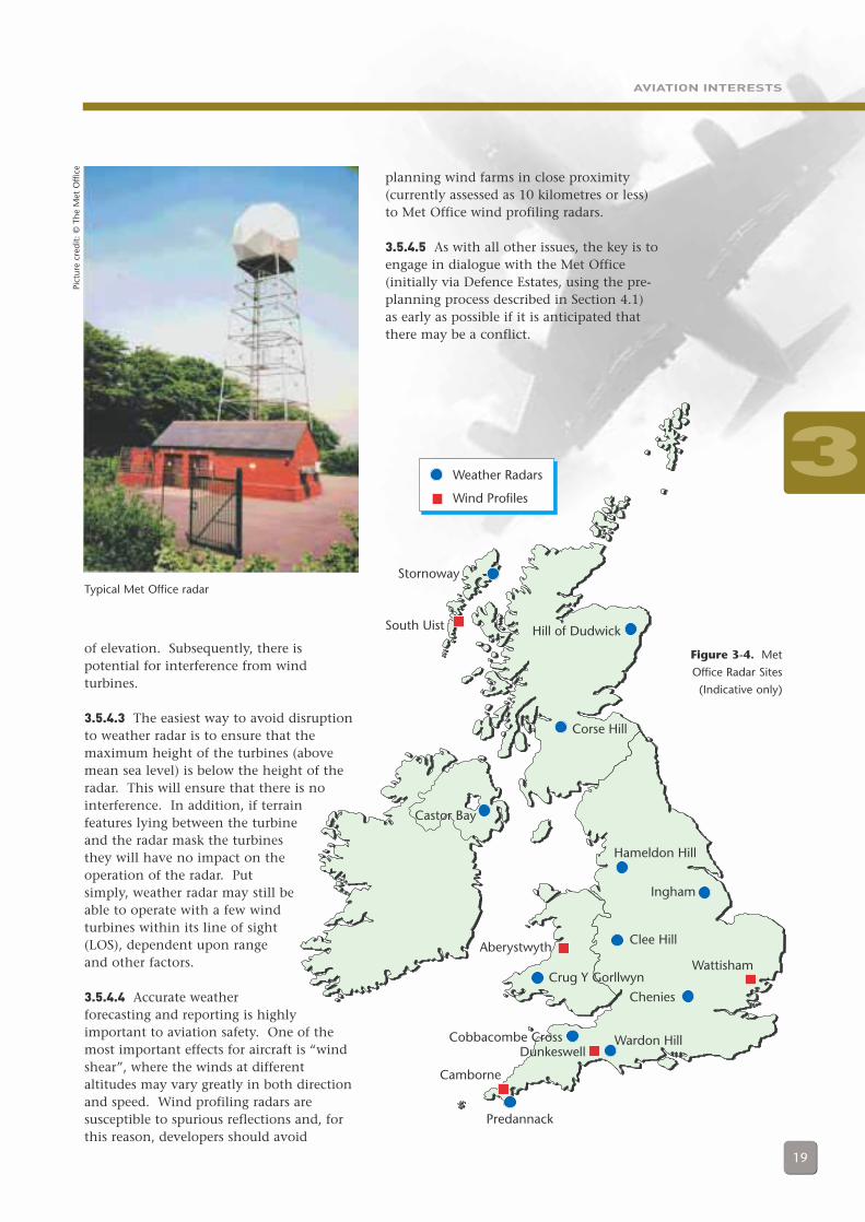
3.5.4 Met Office Radar Considerations
3.5.4.1 There are 12 weather radar stationsin the UK (1 in Northern Ireland, 1 inWales, 3 in Scotland and 7 in England) andthey are used for monitoring weatherconditions to assist in forecasting. A mapof Met Office radar sites is at Figure 3-4. Insimple terms, two types of radar are used:weather radar and wind profiling radar.
3.5.4.2 Weather radar is designed to look ata thin layer of the atmosphere, as close tothe ground as possible, for accurateforecasting. For this reason, sites aresituated on high ground and look out at anarrow band of airspace between 0 and 1°
25 This situation may be clarified as experience of operating in the presence of wind farms increases.
3
AVIATION INTERESTS
19
Hill of Dudwick
Stornoway
South Uist
Castor Bay
Hameldon Hill
Ingham
Clee HillAberystwyth
Crug Y Gorllwyn
Chenies
Wattisham
Wardon Hill
Predannack
Cobbacombe CrossDunkeswell
Camborne
Corse Hill
Weather Radars
Wind Profiles
of elevation. Subsequently, there ispotential for interference from windturbines.
3.5.4.3 The easiest way to avoid disruptionto weather radar is to ensure that themaximum height of the turbines (abovemean sea level) is below the height of theradar. This will ensure that there is nointerference. In addition, if terrainfeatures lying between the turbineand the radar mask the turbinesthey will have no impact on theoperation of the radar. Putsimply, weather radar may still beable to operate with a few windturbines within its line of sight(LOS), dependent upon rangeand other factors.
3.5.4.4 Accurate weatherforecasting and reporting is highlyimportant to aviation safety. One of themost important effects for aircraft is “windshear”, where the winds at differentaltitudes may vary greatly in both directionand speed. Wind profiling radars aresusceptible to spurious reflections and, forthis reason, developers should avoid
planning wind farms in close proximity(currently assessed as 10 kilometres or less)to Met Office wind profiling radars.
3.5.4.5 As with all other issues, the key is toengage in dialogue with the Met Office(initially via Defence Estates, using the pre-planning process described in Section 4.1)as early as possible if it is anticipated thatthere may be a conflict.
Figure 3-4. Met
Office Radar Sites
(Indicative only)
Pict
ure
cred
it: ©
The
Met
Offi
ce
Typical Met Office radar
3
AVIATION INTERESTS
20
3.6 AVIATION INTERESTS -CONCLUSION
3.6.1 Both civil and military aviationcommunities have legitimate interests thatmust be protected; this includes protectionagainst the adverse effects of wind turbines.However, there is scope for flexibilitythroughout the process of considering windfarm applications. The effects of windturbines on the physical element of the airdomain (as obstructions) are wellunderstood and the procedures for handlingthem are relatively straightforward.Certainly, a flexible approach to siting ofturbines can be expected to pay dividends.Developers must, however, bear in mindthat there are some locations in which thepresence of turbines is unlikely ever to betolerated.
3.6.2 The effects of wind turbines onelectronic systems and the measures thatcan be taken to overcome these effects areless clear-cut. The siting of wind turbineswill, potentially, affect the radar sensorsbelonging to both civil and military users inmuch the same ways, although theoperational impact of these effects willprobably not be the same. As furtherresearch is conducted and experience withexisting (and currently approved) windfarms grows, all stakeholders will be able todetermine more precisely what may beacceptable and what will not. No matterwhat, however, this is an area in whichearly dialogue with the relevantstakeholders is particularly recommended.3

THE PLANNING AND CONSULTATION PROCESSES
21
4.1 THE PRE-PLANNINGCONSULTATION PROCESS
4.1.1 It has been emphasised throughoutthe document that early consultation withaviation stakeholders is of vital importanceto address any potential problems as soon inthe development process as possible and toensure that any objections are resolved bythe time a development reaches the formalplanning stage. To assist the process aconsultation proforma has been drawn upand agreed between the BWEA and keyaviation stakeholders (the MOD, CAA andNATS). A blank copy is enclosed at Annex E,along with an example of how the proformashould ideally be completed. The use of thisprocess is voluntary, but developers who donot use it will likely be directed to theconsultation proforma by one of the aviationstakeholders at a later stage of development,with subsequent delays.
4.1.2 It is recognised that all theinformation requested in the proformamight not be available in the early stages ofplanning a development; nevertheless,developers are urged to supply as muchdetail as possible and to double-check theinformation before submission. Ofparticular importance is the positionalinformation supplied, preferably in bothlatitude and longitude and National GridReference (accurate to within 10 metres,where possible)26 and maximum heightabove ground. Where the exact location ofa wind farm is not yet finalised, boundarypoints for an area within which the farm isplanned to be located are sufficient forinitial analysis. Generally, it will bepreferable to give stakeholders details of thelargest case scenario as it allows for theconsideration of smaller alternatives in theevent of problems.
4.1.3 Developers are reminded that,following the submission of the form,responses from MOD, CAA, NATS andAerodromes are valid for a period of 2 years,following which the form must be
resubmitted if the development has notgone ahead. In this case, it is advised that aproposal be resubmitted using a fresh copyof the proforma.
4.1.4 When submitted, the proforma isdistributed by the MOD Defence Estates(DE) and the CAA Directorate of AirspacePolicy (DAP) to relevant stakeholders, whowill study the submission and assess theproposal’s impact, if any, on their area ofinterest. The stakeholders, their concerns,and the mechanics of the process itself aredescribed in the following paragraphs.
4.1.5 Should any of the MOD stakeholdershave any concerns regarding the potentialimpact of a proposal upon their systems oroperations, which they themselves cannotresolve, it is likely that they will, throughDefence Estates, raise an initial objection.This by no means represents the end of theprocess, however. In many cases objectionswill be withdrawn if the developer providesmore information and/or satisfactorydiscussions between the objector and thedeveloper are held.
4.1.6 The Stakeholders4.1.6.1 The primary aviation stakeholders,together with their main areas of interest,are shown in Table 2. Contact details formost of these are given in Annex H.
26 For offshore developments, only latitude and longitude are required.
4 The Planning and Consultation Processes
4
THE PLANNING AND CONSULTATION PROCESSES
22
4.1.7 MOD Policy - General
4.1.7.1 The MOD has issued the followingpolicy statement:
“The MOD is well aware of and fully supportsthe Government’s renewable energy policies andtargets. We can and do adapt military trainingto take account of many interests, including ofthose seeking to develop wind farms in the UK.The MOD’s low flying, air defence andcommunications experts must examine thepotential impact of proposals to site wind farmson the safety of aircrew and the public, and onessential training and operations. To this end,each wind farm proposal seen by MOD isconsidered on its merits.”27
4.1.7.2 As the statement makes clear, everyproposal is individually assessed. For farmsin the LFS in general, the MOD is unlikelyto object unless a proposal is in aparticularly busy or congested part of theLFS and would cause an unworkable hazardto aircraft in the vicinity. Proposals withinTTAs present more danger to aircraft due to
the lower altitudes at which fast jet aircraftmust fly. Nevertheless, a wind farm on theedge of a TTA may well be approved if itpresents little danger to training within theTTA, and several have been developed inthe past.
4.1.8 Defence Estates
4.1.8.1 Defence Estates acts as thefacilitator and focal point for other MODstakeholders. It will therefore have aninterest in all aspects of proposals to ensurethat all MOD concerns (as described againstthe individual stakeholders) are addressed.
4.1.9 Defence Communications Systems Agency
4.1.9.1 The Defence CommunicationsSystems Agency (DCSA) examines proposeddevelopments to assess their impact on allmilitary technical systems, such asmicrowave links and radar. It also, in turn,advises other defence interests of potentialconflicts. Often, simple steps can be taken
Department Primary Area of Interest
Defence Estates, MOD Facilitator and focal point for other MODstakeholders
Property Services Department, Met Office weather radar networkMeteorological Office
MOD Defence Communications Systems Radar and communications linksAgency, Configuration Management Branch
Royal Air Force, Headquarters Strike Military aerodromesCommand, Operations Support(Air Traffic Control)
Royal Air Force, Headquarters 2 Group, Air defence radars and control systemsAir Surveillance and Control Systems
Royal Air Force, London Terminal Control UK Low Flying System (LFS), includingCentre (Military) - Low Flying Tactical Training Areas (TTAs)
Directorate of Flying, MOD (DPA) Civil sites with defence contracts
CAA Directorate of Airspace Policy (DAP) UK Airspace Policy, spectrum managementpolicy and the impact on thecommunications, navigation and surveillance(CNS) infrastructure. Other Civil Aviationinterests eg unlicensed airfields
CAA Safety Regulation Group, Air Traffic Civil licensed aerodromesServices Standards Department (ATSSD);Aerodrome Standards Department
NATS En-Route Limited (NERL) NATS-owned and operated en-route CNSfacilities
Airport operators Civil licensed aerodromes
Table 2.
Principal
Stakeholders and
their Areas of
Interest
4
27 The Pattern of Military Low Flying Across the United Kingdom 2001/02, Ministry of Defence, Directorate of Air Staff.
THE PLANNING AND CONSULTATION PROCESSES
23
to resolve objections raised by DCSA (forexample, interference from wind turbineswith microwave links supporting Commandand Control of air defence operations canbe resolved by relocating the relevantturbines by around 500m).
4.1.9.2 Owing to the number and variety ofsystems for which the agency is responsible,it is not possible to provide a list or map ofDCSA sites of interest. Developers shouldawait DCSA’s initial response, via DefenceEstates, and thereafter engage in dialogue atthe earliest opportunity, as many of theAgency’s objections can be easily resolved.
4.1.10 Headquarters Strike Command,RAF
4.1.10.1 The Headquarters Strike Command(HQSTC) Air Traffic Control (ATC) branch isresponsible for the safe operation ofmilitary aerodromes in the UK, includingArmy Air Corps airfields and Royal NavalAir Stations. Its concerns have beendiscussed in sections 3.1 - 3.2. As thesesections describe, in addition to thephysical safeguarding of verticalobstructions, the effects of wind turbines ontechnical sites are also considered.
4.1.10.2 It should be noted that naval andother maritime issues are not within theremit of these guidelines. However, asstated above, all naval aviation and airfieldsare represented by Royal Air Force StrikeCommand, who will also assess the impact
on army aviation and airspace above andaround military firing ranges.
4.1.10.3 Military sites are distributedthroughout the UK and HQSTC willconsequently have an interest in allproposed developments, regardless oflocation.
4.1.11 Headquarters No. 2 Group, RAF
4.1.11.1 Headquarters No. 2 Group (HQ 2Gp) Air Surveillance and Control Systems(ASACS) branch is concerned with theimpact of wind turbines on the ASACS and,primarily, the effects on long-range ground-based air surveillance. Most of the radarsconcerned are currently located on the eastcoast of the UK28; the associated Commandand Control centres are distributed aroundthe UK but their position is not germane tothe effects. With the change in the securityclimate following the terrorist attacks of 11September 2001, the importance of the airpicture provided by the system hasincreased dramatically.
4.1.11.2 Traditionally, the primary role ofthe ASACS has been to detect aircraftapproaching the UK from overseas.However, equal, if not more, importance isnow given to monitoring the airspaceoverland in the UK, to detect, track andrespond to air traffic which is givingconcern (for example, hijacked aircraft). Inaddition, the significance of the low-levelcover provided by the ASACS has risen
4
28 They were originally sited in this orientation due to Cold War concerns. However, the locations were also found to begenerally the most suitable for routine air policing requirements and the support of training.
THE PLANNING AND CONSULTATION PROCESSES
24
markedly. Consequently, and as describedpreviously, the MOD will be extremelyinterested in any proposed wind turbinedevelopment that has an impact on theASACS system (both radars and Commandand Control), whether the wind farm is on-or offshore.
4.1.11.3 A map of UK ASACS radar sites isin Annex C (Figure C-2).
4.1.12 HQ Strike Command Detachment- London Terminal ControlCentre
4.1.12.1 The London Terminal ControlCentre (LTCC) is a joint military/civil AirTraffic Control Centre (ATCC) responsiblefor the safety of flying. The Low Flying (LF)section is a detachment of HQ StrikeCommand which lodges at LTCC and isresponsible for protecting the interests ofthe UK Low Flying System (LFS), which wasdescribed in Section 3.4. Clearly, whereaircraft are likely to fly at very low levels,any physical obstruction, such as a windturbine, is a hazard to flight safety and forthis reason, the LF section examines everywind energy proposal to assess its impact onlow flying training.
4.1.13 Directorate of Flying, MOD
4.1.13.1 The Directorate of Flying (DFlying) is an office within the DefenceProcurement Agency (DPA) concerned withcivil sites with MOD contracts, and theimpacts of wind turbines upon them. Oneexample of such a site would be BAeSYSTEMS Warton, in Lancashire, where the
Eurofighter project is based. Owing to thewide variety of sites and systems that fallwithin this remit, it is not possible to listthe areas of interest here.
4.1.14 Civil Aviation Authority,Directorate of Airspace Policy
4.1.14.1 The Directorate of Airspace Policy,CAA, is responsible for all UK airspacepolicy and the requirements that it placeson its supporting CNS Infrastructure. Assuch, it acts as the focal point for windturbine activity, ensuring that all civilaviation interests are considered. Inaddition, through the formal Radio SiteClearance process, it handles the pre-planning enquiries and subsequentnotification to aerodrome operators and,where appropriate service providers.Furthermore, DAP addresses theimplications for CNS from an overall UKairspace perspective.
4.1.15 Civil Aviation Authority, SafetyRegulation Group
4.1.15.1 The Safety Regulation Group (SRG)of the CAA ensures that aerodromes are safeto use and that air traffic services andgeneral aviation activities meet requiredsafety standards. Therefore, theconstruction of wind turbines in thevicinity of a licensed aerodrome is ofinterest to the SRG and there are a numberof criteria that the Group use to assessproposals. Chief among these are theguidance and requirements detailed in CivilAir Publication (CAP) 168 and 670.
4.1.15.2 If the proposed development iswithin 17km of an officially safeguardedaerodrome, its impact on the airfield’sprotected surfaces is assessed, as describedunder the safeguarding process; thisaddresses the issue of the turbine(s) as aphysical obstruction. The Air TrafficServices Standards Department (ATSSD)within the SRG also assesses the impact ofthe proposal on any airfield technicalfacilities: if the development is within 30kmof an airfield from where air traffic services(ATS) are provided (or 34km if anInstrument Landing System (ILS) may beaffected), then the aerodrome should
4
THE PLANNING AND CONSULTATION PROCESSES
25
consider the impact. In some cases, NATSor another ATS Service Provider iscontracted to provide the ATS; therefore,they will be asked to provide a technicalsafeguarding assessment. However, in allcases the aerodrome licensee or theirnominated representative will be the pointof contact for any liaison on physical andtechnical safeguarding issues. The onus isthen on the aerodrome licensee and thedeveloper to liaise in order to address anypotential impacts.
4.1.15.3 A list and map of UK safeguardedcivil aerodromes is in Annex C.
4.1.16 NATS En-Route Limited
4.1.16.1 NATS En-Route Limited (NERL)provides ‘en route’ air traffic controlservices to aircraft flying in UK airspace andover the northeastern Atlantic Ocean.NERL therefore has an interest insafeguarding CNS facilities located both atcertain civil aerodromes and at stand-alonetechnical sites.
4.1.16.2 The criteria for consultation on awind turbine proposal is whether or not it iswithin 30km of a facility; however, turbinesfarther away than 30km may be a factor ifthey are in the line of sight (LOS) of thefacility in question. If the development isnot within LOS of the facility, regardless ofrange (for example, shielded by terrain),then NERL is unlikely to object to theproposal. If the proposal is within LOS of atechnical facility, then CAP 670 providesguidance material that can be applied toassess interference of physical obstructionsagainst various types of technicalequipment29. It is unlikely that turbinesthat infringe these criteria will beacceptable.
4.1.16.3 In summary, to avoid conflict withNERL facilities, wind turbines shouldideally: not be within 30km of any radar,navigational aid or communicationsantennae; not be within LOS of any suchfacility at any range; and not infringe theCAP 670 criteria for all such facilities.
4.1.17 Aerodrome Operators (otherthan those covered in 4.1.14)
4.1.17.1 The aerodrome operators, whetherpart of a larger organisation orindependent, will be concerned with allissues that might affect the safety of aircraftusing their airfield. As the aerodromelicence holder, the operator is responsiblefor maintaining the safe operation of theaerodrome. They are, therefore, concernedwith all aspects of any proposal that mayhave a detrimental impact upon the safetyof the aerodrome. For any proposed windturbine development that lies within 30kmof the aerodrome they will determinewhether the height of a proposeddevelopment infringes the protectedsurfaces around the aerodrome and inconjunction with their ATS provider willassess whether there is any impact upon theaerodrome’s radar and the safe provision ofair traffic control. Further informationabout aerodrome operators can be soughtfrom The Airport Operators Association(address at Annex H).
4.1.18 The Stakeholder Contact Flow
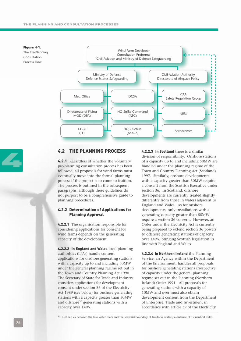
4.1.18.1 A diagram of the pre-planningconsultation process is shown in Figure 4-1;it should be noted that all connecting linesshould represent a two-way dialogueprocess. Furthermore, this diagram shouldin no way be construed as precluding thedeveloper from conducting a dialogue directwith any individual stakeholder. It is,however, recommended that initial contactbe made via the route shown (the dottedlines on the right of the figure indicate adirect feedback path that is established afterinitial contact has been made).
4
29 The gradients are: 1:200 for Secondary Surveillance Radar; 1:100 for Primary Radar; 1:50 for navigation aids andcommunications antennae. Wind turbines should not impinge on these safeguarding slopes.
THE PLANNING AND CONSULTATION PROCESSES
26
4.2 THE PLANNING PROCESS
4.2.1 Regardless of whether the voluntarypre-planning consultation process has beenfollowed, all proposals for wind farms musteventually move into the formal planningprocess if the project is to come to fruition.The process is outlined in the subsequentparagraphs, although these guidelines donot purport to be a comprehensive guide toplanning procedures.
4.2.2 Determination of Applications forPlanning Approval
4.2.2.1 The organisation responsible forconsidering applications for consent forwind farms depends on the generatingcapacity of the development.
4.2.2.2 In England and Wales local planningauthorities (LPAs) handle consentapplications for onshore generating stationswith a capacity up to and including 50MWunder the general planning regime set out inthe Town and Country Planning Act 1990.The Secretary of State for Trade and Industryconsiders applications for developmentconsent under section 36 of the ElectricityAct 1989 (see below) for onshore generatingstations with a capacity greater than 50MWand offshore30 generating stations with acapacity over 1MW.
44.2.2.3 In Scotland there is a similardivision of responsibility. Onshore stationsof a capacity up to and including 50MW arehandled under the planning regime of theTown and Country Planning Act (Scotland)1997. Similarly, onshore developmentswith a capacity greater than 50MW requirea consent from the Scottish Executive undersection 36. In Scotland, offshoredevelopments are currently treated slightlydifferently from those in waters adjacent toEngland and Wales. As for onshoredevelopments, only installations with agenerating capacity greater than 50MWrequire a section 36 consent. However, anOrder under the Electricity Act is currentlybeing prepared to extend section 36 powersto offshore generating stations of capacityover 1MW, bringing Scottish legislation inline with England and Wales.
4.2.2.4 In Northern Ireland the PlanningService, an Agency within the Departmentof the Environment, handles all proposalsfor onshore generating stations irrespectiveof capacity under the general planningregime set out in the Planning (NorthernIreland) Order 1991. All proposals forgenerating stations with a capacity of10MW and over must also obtaindevelopment consent from the Departmentof Enterprise, Trade and Investment inaccordance with article 39 of the Electricity
Figure 4-1.
The Pre-Planning
Consultation
Process Flow
Wind Farm DeveloperConsultation Proforma:
Civil Aviation and Ministry of Defence Safeguarding
Ministry of DefenceDefence Estates Safeguarding
Civil Aviation AuthorityDirectorate of Airspace Policy
Met. Office DCSACAA
Safety Regulation Group
Directorate of FlyingMOD (DPA)
HQ Strike Command(ATC)
NERL
AerodromesLTCC(LF)
HQ 2 Group(ASACS)
30 Defined as between the low water mark and the seaward boundary of territorial waters, a distance of 12 nautical miles.

THE PLANNING AND CONSULTATION PROCESSES
27
(Northern Ireland) Order 1992. TheElectricity Act 1989 does not extend toNorthern Ireland, although the proceduresunder the 1992 Order are broadly the same.
4.2.3 Guidance Available to LocalPlanning Authorities
4.2.3.1 It should be noted that the formerDTLR has undertaken a major review of theplanning system and published proposalsin a Green Paper in December 200131 forspeeding up the determination of planningapplications. In July 2002 the Office of theDeputy Prime Minister (ODPM) issued aplanning policy statement “SustainableCommunities - Delivering throughPlanning” which sets out the Government’splans for reform of the planning system32.
4.2.3.2 Guidance on Renewable EnergyProjects
4.2.3.2.1 In England Planning PolicyGuidance Note 22 (PPG22) (1993) promotesthe environmental benefits of increasingrenewable energy generation and includesan annex on the implications of windenergy. The ODPM has given acommitment to revise this document. InWales, more general guidance is given inPlanning Policy Wales (PPW) (republished
March 2002), with detailed guidancerelating to wind energy in Technical AdviceNote 8 (TAN8) (1996). A review of TAN8 iscurrently underway, with a draftconsultation due at the end of 2002 orearly 2003. PPW and TANs, together withWelsh Office circulars, together compriseWelsh national planning policy.
4.2.3.2.2 It should be noted that regional-level energy strategies are being developed,which are designed to engender a positiveapproach to renewables planning.
4.2.3.2.3 In Scotland National PlanningPolicy Guideline 6 (NPPG6) (revised January2000) sets wide objectives for renewableenergy development within the context ofthe national target. More information onthe implications on the different renewabletechnologies is given in Planning AdviceNote (PAN) 45; this includes a detailedsection on wind power and was revised inJanuary 2002.
4.2.3.2.4 In Northern Ireland the RegionalDevelopment Strategy 2025 promotes theuse of renewable sources of energy andalternative energy technologies. Specificpolicy guidance for renewable technologiesis given in Policy PSU 12 of the PlanningStrategy for Rural Northern Ireland (1993).
4
31 Planning: Delivering a Fundamental Change, DTLR, December 2001.32 Further details are available on ODPM’s website at: www.planning.odpm.gov.uk/consult/greenpap/makebett/index.htm
THE PLANNING AND CONSULTATION PROCESSES
28
4.2.3.3 Guidance on Aviation-related Issues
4.2.3.3.1 In considering aviation-relatedaspects of applications for planningapproval LPAs will follow the processes andthe guidance outlined in section 3.2 aboveon the Safeguarding of Aviation Interests.
4.2.3.4 Section 36 of the Electricity Act 1989
4.2.3.4.1 As described above, certain windfarm proposals in England, Wales andScotland are subject to consent undersection 36 of the Electricity Act 1989.Under section 36, the Secretary of State forTrade & Industry considers applications forgenerating stations in England and Wales;the DTI consults the Welsh AssemblyGovernment on the latter. As section 36powers have been devolved, ScottishExecutive Ministers make decisions onrelevant proposals in Scotland. Thelegislation is constructed to enableGovernment Ministers to make a decisionwithin the broader context of energypolicy, whilst recognising the interests ofthe LPA in which the development isplanned to be located.
4.2.3.4.2 While consent ultimately restswith the relevant Minister, LPAs also receivea copy of the application. The planningauthority will follow the relevant aviationguidance (as described above) and may raisean objection. If this objection is sustainedand cannot be addressed by modification tothe project, then a public enquiry will beheld. The Government Minister(s) will takethe outcome of the public enquiry intoaccount when making a final decision.
4.2.3.4.3 At the same time, the DTI orScottish Executive will be carrying out theirown consultations. While not statutoryconsultees in the section 36 process, theviews of the CAA and MOD will be soughtas a matter of course. At any stage, theMinisters concerned have the right to call apublic enquiry in the light of the objectionsthey receive, and the outcome will be takeninto account in their final decision.
4.2.3.4.4 Other consents are also requiredfor offshore wind farms, but these are notrelated to aviation and, thus, are notdescribed here33. The question of howrenewables projects outside territorial watersmight receive consent will be addressed in aconsultation document on a future strategyfor wind farms to be issued by the DTI inautumn 2002.
4.2.3.5 The Transport and Works Act 1992
4.2.3.5.1 If a development is likely tointerfere with rights of navigation inEnglish & Welsh territorial waters,developers may apply for approval underthe Transport and Works Act 1992 as analternative to section 36 consent. Whendevelopers follow this route, the Secretaryof State for Trade and Industry (in England)or the Welsh Assembly Government willconsider applications. They will consultwith the LPA before making a decision ondevelopment approval.
4
33 Specifically, a licence from the DfT under Section 34 of the Coastal Protection Act 1949 and a licence from DEFRA underSection 5 of the Food and Environment Protection Act 1985. Applications for these separate licences are submitted to theDTI which works with other relevant Government Departments to co-ordinate the administrative processes and produce amore streamlined system; see Guidance Notes: Offshore Wind Farm Consents Process, DTI, due Autumn 2002.
WIND ENERGY AND AVIATION INTERESTS – INTERIM GUIDELINES
29
5.1 All parties should recognise the needsof others involved in the process. Windfarm developers should understand thelegitimate concerns of the aviation anddefence communities; aviation and defencestakeholders should bear in mind theimportance of wind farms in meetingnational energy needs. The key is earlydialogue between all stakeholders with aninterest. Early consultation can help toidentify non-viable proposals and so keepwasted resources to a minimum. Alternativepossibilities may emerge from the dialogueand wind farm developers should gain abetter understanding of the concerns ofaviation stakeholders and how individualapplications are assessed. Once established,the dialogue needs to be maintained. Asproposals for developments become moredetailed their likely effects on aviationinterests can be assessed in greater depth.
5.2 There is no doubt that certaininteractions between wind farms andaviation have, in the past, appearedintractable. Wind turbines do have effectson both civil and military aviation. In fact,many issues can be resolved based upon theguidance in this document. Others, such asthe effects of turbines on radar installations,will still have to be considered on a detailedcase-by-case basis and not all theinformation that may be necessary toreassure stakeholders fully in this area mayyet be available. There is, nevertheless,good reason for optimism that these issuesmay be resolved both in general andspecific cases.
5.3 This edition of the guidelinesprovides interim guidance. It is a livingdocument and the intention is to update itin the light of the findings from researchcurrently under way and to incorporatefeedback from all stakeholders (which iswelcomed via the feedback form at AnnexI). In the meantime it is clear that earlyand regular consultation with all therelevant stakeholders can make theplanning process much easier for thedeveloper.
5 Conclusion
5
Pict
ure
cred
it: ©
Pau
l Car
ter/
Win
d Pr
osp
ect
ANNEXES
30
A. BACKGROUND TO THE GUIDELINESB. WIND POWERC. SAFEGUARDED SITES -
LISTS AND MAPSD. RADAR SYSTEMS AND THE EFFECTS OF
WIND TURBINESE. PRE-PLANNING CONSULTATION FORMF. GLOSSARYG. LIST OF ACRONYMSH. CONTACT ADDRESSESI. FEEDBACK PROFORMA
6 Annexes
6
ANNEX A – BACKGROUND TO THE GUIDELINES
31
A1 The Wind Energy, Defence and CivilAviation Interests Working Group wasformed as a result of an initiative by theDepartment of Trade and Industry (DTI) inearly 2001 to review the issues surroundingwind energy development and civil andmilitary aviation activities. The Groupcomprises a cross-section of stakeholders,including representatives from the BritishWind Energy Association (BWEA) on behalfof the wind energy industry, the Ministry ofDefence (MOD), the DTI, the Civil AviationAuthority (CAA), and National Air TrafficServices (NATS). The Scottish Executiveprovides guidance on Scottish issues. TheWorking Group commissioned theguidelines, has overseen their developmentand will be responsible for their updating.
A2 In addition to the guidelines threeother studies have been commissioned as aresult of the Group’s work. Their respectiveobjectives are:
• To develop a model to predict theeffects of wind turbines on radarinstallations.
• To investigate mitigation measures toreduce the potential effects of windturbines on radar installations.
• To review European experiences inthe process of balancing the interestsof wind farm development, aviationsafety, and air defences.
Further details of these studies are providedat Annex D.
A3 These studies are expected to providea substantial input to the understanding ofmany of the effects of wind turbines onaviation. Their full findings are not yetavailable but they will be incorporated intosubsequent versions of this document. Forthe present the guidelines seek to clarifyissues of concern to the wind industry andaviators regarding each other’s interests and,in particular, to offer guidance to developersas to the areas of concern of stakeholderswithin both civil and military aviation.
ANNEX ABackground to the Guidelines
A
A4 Terms of reference for the AviationWorking Group follow.
TERMS OF REFERENCE OF THEWIND ENERGY, DEFENCE ANDCIVIL AVIATION INTERESTSWORKING GROUP
AIMTo produce public domain guidance onthe appropriate siting of both onshoreand offshore wind turbines, with respectto their likely effects on defence and civilaviation interests.
OBJECTIVESTo share information concerning theeffects of wind turbines on defence andcivil aviation interests.
• To streamline and formalise thewind farm development applicationprocess.
• To identify the issues associatedwith defence and civil aviationinterests, which may effect thedevelopment of wind energy in theUK.
• To develop a programme of work toboth evaluate the issues identifiedand subsequently to generateappropriate solutions or mitigationmeasures to any problemsidentified.
• To generate guidance acceptable toall stakeholders.
• To encourage the widespreadadoption of the guidance.
ANNEX B – WIND POWER
32
B1 INTRODUCTION
B1.1 The amount of electricity generatedby wind turbines depends on two keyfactors - the wind resource and the sweptarea of the wind turbine rotor. Thus theenergy produced is highly dependent uponthe average wind speed at the chosen siteand the size of the turbine.
B1.2 This said, however, relatively smallincreases in wind speed and blade size canresult in large increases in the amount ofelectricity generated. This is for thefollowing reasons:
• Wind speed: the power availableincreases with the cube of the windspeed - for example a machine on asite with a mean wind speed of 5metres per second (m/s) will produceless than half the electricity of thesame size turbine on a site with amean wind speed of 7m/s.
• Blade size: the area swept by the rotorincreases by the square of the rotordiameter, so doubling the length of aturbine’s blades actually quadruplesthe amount of energy produced.
B1.3 Developers can assess wind speed bycorrelating historical data available from theMet Office with information derived fromon site wind measurements. Wind mastsare typically located on a site for a period of12 months. While wind speed is vital, thereis a range of other technical andenvironmental factors that must beconsidered when choosing sites suitable forwind farm development.
B2 GENERIC SITEREQUIREMENTS FOR WIND ENERGY
B2.1 Ideal wind farm sites are to be foundon high, exposed land, which can causeconflict with aviation interests such as lowflying or radar siting. In order to export the
power generated the chosen site must havea technically and commercially feasibleconnection to the electricity distributionsystem as well as suitable access for vehicles,including large articulated vehicles duringthe construction phase.
B2.2 ENVIRONMENTAL FACTORS
B2.2.1 A key consideration is the effect ofthe development on landscape and visualinterests. Therefore, opportunities forschemes in national designations such asNational Parks or Areas of OutstandingNatural Beauty are generally limited andeven outside these areas carefulconsideration of local designations andgeneral landscape issues such as views fromkey public viewpoints must be considered.
B2.2.2 Wind farms should not be so closeto domestic dwellings that they affect themby noise, shadow flicker, visual dominationor reflected light. Consideration should begiven to ecological designations and whetherprotected species are found at a proposedsite. Listed buildings, Conservation Areasand archaeological sites may all influence theacceptability of a wind farm site.
B2.2.3 In finding an appropriate site adeveloper must therefore consider a rangeof factors and commit considerable timeand resources in advance of moving forwardwith a planning application and fullenvironmental assessment.
B3 WIND TURBINECHARACTERISTICS
B3.1 Almost all wind turbines producingelectricity for the electricity grid consist of a3-bladed rotor that rotates around ahorizontal hub. The hub is connected to agearbox and generator, which are locatedinside the nacelle. The nacelle houses theelectrical components and is mounted atthe top of the tower. This is illustrated inFigure B-1.
ANNEX BWind Power
B
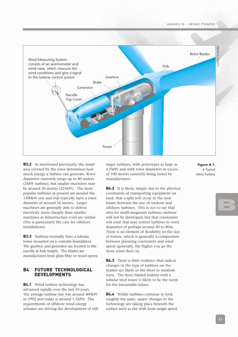
ANNEX B – WIND POWER
33
B3.2 As mentioned previously, the sweptarea covered by the rotor determines howmuch energy a turbine can generate. Rotordiameters currently range up to 80 metres(2MW turbine), but smaller machines maybe around 30 metres (225kW). The mostpopular turbines at present are around the1300kW size and will typically have a rotordiameter of around 56 metres. Largermachines are generally able to deliverelectricity more cheaply than smallermachines as infrastructure costs are similar(this is particularly the case for offshoreinstallations).
B3.3 Turbines normally have a tubulartower mounted on a concrete foundation.The gearbox and generator are located in thenacelle at hub height. The blades aremanufactured from glass fibre or wood epoxy.
B4 FUTURE TECHNOLOGICALDEVELOPMENTS
B4.1 Wind turbine technology hasadvanced rapidly over the last 10 years.The average turbine size was around 400kWin 1992 and today is around 1.5MW. Therequirements of offshore wind energyschemes are driving the development of still
Figure B-1.
A Typical
Wind Turbine
larger turbines, with prototypes as large as4.5MW and with rotor diameters in excessof 100 metres currently being tested bymanufacturers.
B4.2 It is likely, simply due to the physicalconstraints of transporting equipment onland, that a split will occur in the nearfuture between the size of onshore andoffshore turbines. This is not to say thatsites for multi-megawatt turbines onshorewill not be developed, but that constraintswill exist that may restrict turbines to rotordiameters of perhaps around 60 to 80m.There is an element of flexibility in the sizeof towers, which is generally a compromisebetween planning constraints and windspeed (generally, the higher you go themore wind there is).
B4.3 There is little evidence that radicalchanges in the type of turbines on themarket are likely in the short to mediumterm. The three bladed turbine with atubular steel tower is likely to be the normfor the foreseeable future.
B4.4 Whilst turbines continue to lookroughly the same, major changes in thetechnology are taking place beneath thesurface such as the shift from single speed
Wind Measuring Systemconsists of an anernometer andwind vane, which measure thewind conditions and give a signalto the turbine control system
NacelleTop Cover
GeneratorBrake
Gearbox
Hub
Rotor Blades
Tower
BC
ourt
esy
of N
orde
x
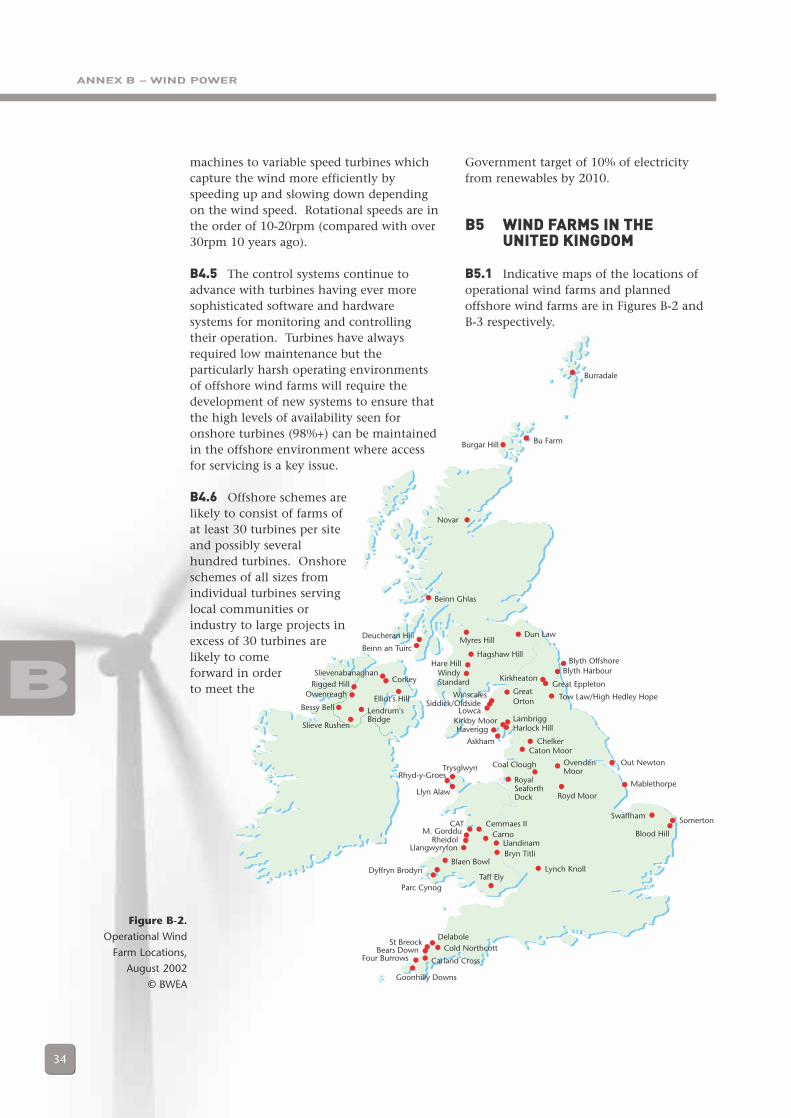
ANNEX B – WIND POWER
34
Government target of 10% of electricityfrom renewables by 2010.
B5 WIND FARMS IN THE UNITED KINGDOM
B5.1 Indicative maps of the locations ofoperational wind farms and plannedoffshore wind farms are in Figures B-2 and B-3 respectively.
Figure B-2.
Operational Wind
Farm Locations,
August 2002
© BWEA
B
Burgar Hill Bu Farm
Novar
Beinn Ghlas
Myres Hill
GreatOrton
Hagshaw HillHare Hill
WindyStandard
Dun Law
Burradale
Deucheran Hill
Beinn an Tuirc
Blyth OffshoreBlyth Harbour
KirkheatonGreat Eppleton
Tow Law/High Hedley HopeWinscalesSiddick/Oldside
LowcaLambriggHarlock Hill
ChelkerCaton Moor
Royd Moor
RoyalSeaforthDock
Kirkby MoorHaverigg
Askham
Out Newton
Mablethorpe
Somerton
Blood Hill
Swaffham
Coal Clough OvendenMoor
Lynch Knoll
Bryn TitliLlandinam
CarnoCemmaes II
Taff Ely
TrysglwynRhyd-y-Groes
Llyn Alaw
M. GordduRheidol
Llangwyryfon
Blaen Bowl
CAT
Dyffryn Brodyn
Parc Cynog
St BreockBears Down
Four Burrows
SlievenabanaghanCorkey
Elliot's Hill
Lendrum'sBridge
Slieve Rushen
Bessy Bell
Rigged HillOwenreagh
DelaboleCold Northcott
Carland Cross
Goonhilly Downs
machines to variable speed turbines whichcapture the wind more efficiently byspeeding up and slowing down dependingon the wind speed. Rotational speeds are inthe order of 10-20rpm (compared with over30rpm 10 years ago).
B4.5 The control systems continue toadvance with turbines having ever moresophisticated software and hardwaresystems for monitoring and controllingtheir operation. Turbines have alwaysrequired low maintenance but theparticularly harsh operating environmentsof offshore wind farms will require thedevelopment of new systems to ensure thatthe high levels of availability seen foronshore turbines (98%+) can be maintainedin the offshore environment where accessfor servicing is a key issue.
B4.6 Offshore schemes arelikely to consist of farms ofat least 30 turbines per siteand possibly severalhundred turbines. Onshoreschemes of all sizes fromindividual turbines servinglocal communities orindustry to large projects inexcess of 30 turbines arelikely to comeforward in orderto meet the
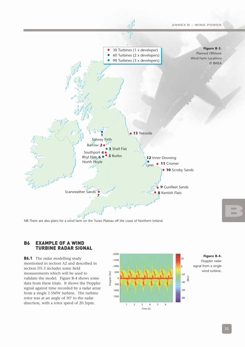
30 Turbines (1 x developer)60 Turbines (2 x developers)90 Turbines (3 x developers)
13 Teesside
12 Inner Dowsing
11 Cromer
10 Scroby Sands
9 Gunfleet Sands
8 Kentish FlatsScarweather Sands
Rhyl Flats 5 BurboSouthport
3 Shell FlatBarrow
1Solway Firth
North HoyleLynn
2
6
7
4
ANNEX B – WIND POWER
35
NB There are also plans for a wind farm on the Tunes Plateau off the coast of Northern Ireland.
Figure B-3.
Planned Offshore
Wind Farm Locations
© BWEA
B
B6 EXAMPLE OF A WINDTURBINE RADAR SIGNAL
B6.1 The radar modelling studymentioned in section A2 and described insection D5.3 includes some fieldmeasurements which will be used tovalidate the model. Figure B-4 shows somedata from these trials. It shows the Dopplersignal against time recorded by a radar arrayfrom a single 1.5MW turbine. The turbinerotor was at an angle of 30° to the radardirection, with a rotor speed of 20.3rpm.
–2000
–1500
–1000
–500
0
500
1000
1500
Do
pp
ler
(Hz)
1 2 3 4 5 6
Time (s)
20
0
–20
–40
–60
–80
dB
sm
Figure B-4.
Doppler radar
signal from a single
wind turbine.
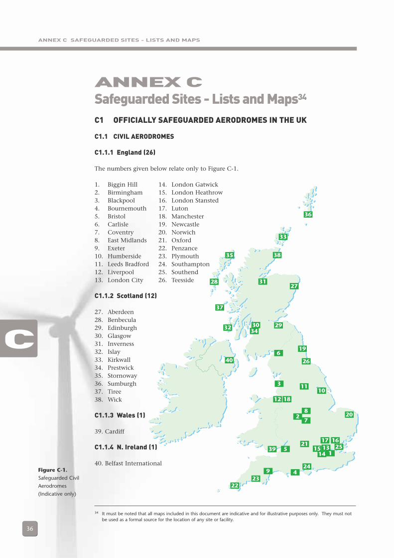
ANNEX C SAFEGUARDED SITES - LISTS AND MAPS
36
Figure C-1.
Safeguarded Civil
Aerodromes
(Indicative only)
ANNEX CSafeguarded Sites - Lists and Maps34
C
34 It must be noted that all maps included in this document are indicative and for illustrative purposes only. They must notbe used as a formal source for the location of any site or facility.
1
2
3
4
5
6
7
8
9
1011
12
1314
151617
18
19
20
21
2223
24
25
26
2728
2930
31
32
33
34
35
36
37
38
39
40
C1 OFFICIALLY SAFEGUARDED AERODROMES IN THE UK
C1.1 CIVIL AERODROMES
C1.1.1 England (26)
The numbers given below relate only to Figure C-1.
1. Biggin Hill 2. Birmingham3. Blackpool4. Bournemouth5. Bristol6. Carlisle7. Coventry8. East Midlands9. Exeter10. Humberside11. Leeds Bradford12. Liverpool13. London City
C1.1.2 Scotland (12)
27. Aberdeen28. Benbecula29. Edinburgh30. Glasgow31. Inverness32. Islay33. Kirkwall34. Prestwick35. Stornoway36. Sumburgh37. Tiree38. Wick
C1.1.3 Wales (1)
39. Cardiff
C1.1.4 N. Ireland (1)
40. Belfast International
14. London Gatwick15. London Heathrow16. London Stansted17. Luton18. Manchester19. Newcastle20. Norwich21. Oxford22. Penzance23. Plymouth24. Southampton25. Southend26. Teesside
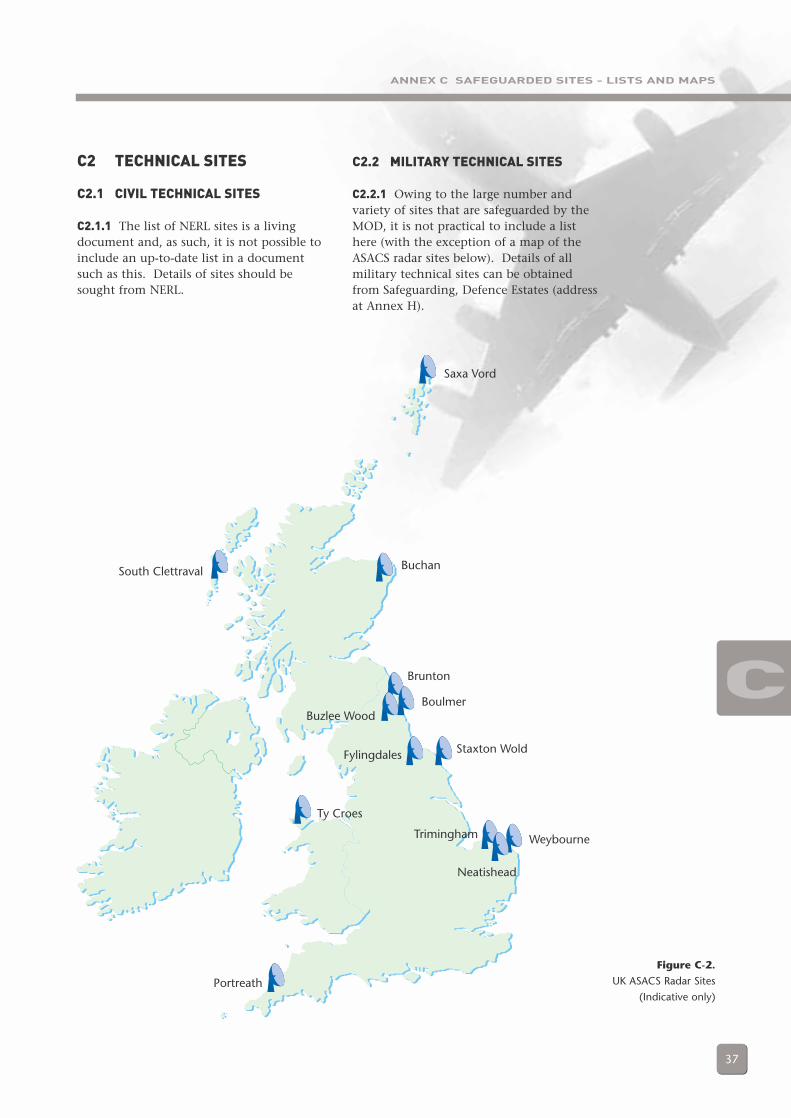
ANNEX C SAFEGUARDED SITES - LISTS AND MAPS
37
Figure C-2.
UK ASACS Radar Sites
(Indicative only)
C
Saxa Vord
BuchanSouth Clettraval
Boulmer
Staxton WoldFylingdales
Ty Croes
Brunton
Buzlee Wood
Trimingham
Neatishead
Weybourne
Portreath
C2 TECHNICAL SITES
C2.1 CIVIL TECHNICAL SITES
C2.1.1 The list of NERL sites is a livingdocument and, as such, it is not possible toinclude an up-to-date list in a documentsuch as this. Details of sites should besought from NERL.
C2.2 MILITARY TECHNICAL SITES
C2.2.1 Owing to the large number andvariety of sites that are safeguarded by theMOD, it is not practical to include a listhere (with the exception of a map of theASACS radar sites below). Details of allmilitary technical sites can be obtainedfrom Safeguarding, Defence Estates (addressat Annex H).
ANNEX D – RADAR SYSTEMS AND THE EFFECTS OF WIND TURBINES
38
D1 GENERAL
D1.1 There are two types of radar used forair traffic control and air defence controland surveillance: primary radar andsecondary surveillance radar (SSR).
D1.2 Primary radar operates by radiatingelectromagnetic energy and detecting thepresence and character of the echo returnedfrom reflecting objects. Comparison of thereturned signal with that transmitted yieldsinformation about the target, such aslocation, size and whether it is in motionrelative to the radar.
D1.3 Primary radar cannot differentiatebetween types of object; its energy willbounce off any reflective surface in its path.Moreover, air traffic control primary radarhas no means of determining the height ofan object, whereas modern air defenceradars do possess this capability, usingelectronic beam control techniques.
D1.4 For SSR, the ground station emits‘interrogation’ pulses of RF energy via thedirectional beam of a rotating antennasystem. When the antenna beam is pointingin the direction of an aircraft, airborneequipment, known as a transponder,transmits a reply to the interrogation. Thereply is detected by the ground station andprocessed by a plot extractor. The plotextractor measures the range and bearing ofthe aircraft and decodes the aircraft replies todetermine the aircraft’s flight level andidentity (Mode C operation).
D1.5 In the UK, all aircraft flying above10,000 feet or in controlled airspace must carrya SSR transponder. Some light aircraft do not,and aircraft that do carry them may not havethem switched on, in which case they will notbe visible to SSR. Most ATC units are equippedwith both primary and SSR, but, increasingly,radar services are provided using SSR only,especially at levels above 24,500 feet.
ANNEX DRadar Systems and the Effects of Wind Turbines
D
D1.6 From 2005 onwards, a new type ofSSR called ‘Mode S’ will begin to beintroduced in UK airspace. Mode S is adevelopment of classical SSR that overcomesmany of the current limitations of the SSRsystem. It is proposed, subject to formalconsultation, to introduce Mode S initiallyin 2005 with a second phase of regulatorychanges in 2008. In addition, it is proposedthat the requirements for the carriage andoperation of transponders will besignificantly extended in conjunction withthe Mode S plans for 2008.
D2 RADAR FUNCTIONS
D2.1 AIR TRAFFIC CONTROL (ATC)
D2.1.1 Radar performs two functions for airtraffic control:
a) Aerodrome surveillance radar allowsair traffic controllers to provide airtraffic services to aircraft in thevicinity of an airport. This servicemay include vectoring aircraft to land,providing a radar service to departingaircraft or providing a service toaircraft either transiting through thearea or in the airfield circuit.
b) En route (or area) radars (which in theUK are all operated by NATS) are usedto provide services to traffic in transit.This includes commercial airliners andmilitary traffic. Area radars have alonger range than aerodrome radars,particularly at high altitudes.
D2.2 AIR DEFENCE
D2.2.1 Air Defence radars are used in twoways. On the one hand, they perform asimilar function to their ATC counterparts,in that they are used by air defencecontrollers to provide control services tomilitary (usually air defence) traffic.However, they are also used to monitor all
ANNEX D – RADAR SYSTEMS AND THE EFFECTS OF WIND TURBINES
39
air traffic activity within the UK and itsapproaches in order that a Recognised AirPicture (RAP) can be produced, with the aimof preserving the integrity of UK airspacethrough air policing. The RAP is producedby allocating Track Identities to each radarreturn (or “plot”) of interest. Often, a radarplot can fade from a radar display for aperiod of time due to a number of factors,but the Track Identity will remain,indicating that the associated plot is stillactually present.
D2.3 METEOROLOGICAL RADARS
D2.3.1 Met Office weather radars use EMenergy to monitor weather conditions(predominantly cloud and precipitation) atlow altitudes, in order to assist weatherforecasting. Wind profiling radars are usedto measure wind speed at different altitudes.
D3 THE NATURE OF THEIMPACTS OF WINDTURBINES
D3.1 MASKING
D3.1.1 This is the main anticipated effecton air defence surveillance radars. Suchradars work at high radio frequencies andtherefore depend on a clear “line of sight”to the target object for successful detection.It follows that any geographical feature orstructure which lies between the radar andthe target will cause a shadowing ormasking effect; indeed this phenomenon isreadily exploited by military aircraftwishing to avoid detection. It is possiblethat, depending on their size, wind turbinesmay cause shadowing effects. Such effectsmay be expected to vary, depending uponthe turbine dimensions, the type oftransmitting radar and the aspect of theturbine relative to it.
D3.1.2 The Met Office is also concernedwith the effect of masking on their sensors.Met Office radars look at a relatively narrowaltitude band, as near to the earth’s surfaceas possible. Due to the sensitivity of theradars, wind turbines, if they are poorlysited, have the potential to significantlyreduce weather radar performance.
D3.2 RADAR RETURNS/RADARCLUTTER
D3.2.1 Radar returns may be received fromany radar-reflective surface. In certaingeographical areas, or under particularmeteorological conditions, radarperformance may be adversely affected byunwanted returns, which may mask thoseof interest. Such unwanted returns areknown as radar clutter. Clutter is displayedto a controller as “interference” and is ofconcern primarily to ASACS and aerodromeradar operators, because it occurs moreoften at lower altitudes.
D3.2.2 For an aerodrome radar operator, awind turbine or turbines in the vicinity ofhis airfield can present operationalproblems. If the turbine generates a returnon his radar screen and the controllerrecognises it as such, he may choose toignore it (as is the case, for example, at RAFMarham). However, such unwanted returnsmay obscure others that genuinely representaircraft, thereby creating a potential hazardto flight safety. This may be of particularconcern in poor weather.
D3.2.3 A structure which permanentlypaints on the radar in the same position ispreferable to one that only presents anintermittent return. This is because anintermittent return is more likely torepresent a manoeuvring or unknownaircraft, obliging the controller to actaccordingly. With this in mind, it is possiblethat aviators and radar operators could worksafely with one or perhaps two turbines inthe vicinity of an aerodrome. Of greaterconcern is the prospect of a proliferation ofturbines, which could potentially saturate anairfield radar picture, making safe flyingoperations difficult to guarantee.
D3.2.4 Several turbines in close proximityto each other, painting on radar, canpresent particular difficulties for long-rangeair surveillance radars. A rotating windturbine is likely to appear on a radar displayintermittently (studies suggest a workingfigure to be one paint every six sweeps).Multiple turbines, in proximity to eachother, will present several returns duringevery radar sweep, causing a ‘twinkling’
D
ANNEX D – RADAR SYSTEMS AND THE EFFECTS OF WIND TURBINES
40
effect. As these will appear at slightlydifferent points in space, the radar systemmay interpret them as being one or moremoving objects and a surveillance radar willthen initiate a ‘track’ on the returns. Thiscan confuse the system and may eventuallyoverload it with too many tracks. Measurescan be taken to mitigate this problem andthey are amplified in Section D4, but thesetoo have their drawbacks.
D3.3 ‘SCATTERING’, ‘REFRACTION’AND/OR ‘FALSE RETURNS’
D3.3.1 Scattering occurs when the rotatingwind turbine blades reflect, or refract radarwaves in the atmosphere. These are thensubsequently absorbed either by the sourceradar system or another system and canthen give false information to that system.It may affect both primary and SSR radars.This effect is as yet unquantified but iscertainly possible - it has, for example, beenwitnessed at Copenhagen airport as a resultof the Middelgrunden offshore wind farm.
D3.3.2 The possible effects are:
a) Multiple, false radar returns beingdisplayed to the radar operator: bladereflections may be displayed at thecontroller’s console as spurious radarcontacts.
b) Radar returns from genuine aircraftbeing displayed, but in an incorrectlocation (range, azimuth or both).
c) Garbling or loss of SSR information.The SSR code allocated to an aircraftmay not be received correctly at theradar installation because ofattenuation, scattering or refractioneffects. Moreover, it is possible thatdisplayed aircraft altitudeinformation derived from Mode ‘C’(described in Section D1.4) may alsobe lost or degraded.
D4 POTENTIAL MITIGATINGMEASURES
D4.1 TECHNICAL MEASURES
D4.1.1 Moving Target Indicator Processing
D4.1.1.1 Objects that are moving cause ashift in the frequency of the returned EMenergy to the radar receiver; this is knownas Doppler shift. Moving Target Indicator(MTI) processing removes from the displayany returned pulses which indicate nomovement or are within a specified range ofDoppler shift. This removes unnecessaryclutter, eliminates unwanted moving targets(such as road traffic) and makes movingtargets above a certain velocity more visible.
D4.1.1.2 Rotating wind turbine blades canimpart Doppler shift to EM energyreflecting off the blades. Depending on theMTI thresholds set in the radar processor,this may be displayed as a moving target.Changes in wind direction at the turbine,the position of the blade in its rotation, theblade pitch, plus other factors, may causethe amount of energy returned to the radaron different sweeps to vary. At single-turbine sites, a radar return will berepeatedly displayed in the same positionand MTI processing can be deployed.However, multiple-turbine sites cause adifferent effect and MTI processing is muchmore difficult. On one return, blades fromone (or more) turbine(s) may paint on theradar; on the next sweep, the blades of adifferent turbine may paint. This can createthe appearance of radar returns movingaround within the area of the wind farm.
D4.1.1.3 On both aerodrome and airdefence radar this can appear (dependingon the type of radar and the processingthresholds in effect) as unknown aircraftmanoeuvring unpredictably. On air defenceradars such as those used in the UK ASACS,the overall system may well interpret theactivity as an aircraft and automaticallystart tracking the activity.
D4.1.2 Filters
D4.1.2.1 It is technically possible withmany radars to filter out returns from agiven area to ensure they are not presentedon operational displays. However, this is atthe expense of detecting actual aircraft inthe area concerned. In the case of radarsthat have the ability to discriminate returnsin height, it may be possible to filter outonly the affected height band. On other
D
ANNEX D – RADAR SYSTEMS AND THE EFFECTS OF WIND TURBINES
41
radars, all returns in the given area will belost and, in effect, no overall operationalbenefit is gained.
D4.1.3 Non-Automatic Initiation
D4.1.3.1 A measure that can be takenwithin the Command and Control systemto mitigate the effects of spurious radarreturns is to establish what is known as aNon-Automatic Initiation (NAI) area.Within this area the system does notperform its normal function of automatictrack association and correlation. Thiswould prevent the system attempting tocorrelate the returns from a large number ofturbines in order to form what it perceivesto be aircraft tracks. Instead, a humanoperator monitors the affected area tomanually detect genuine aircraft tracks.Whilst this technique can help to avoid theproblems both for surveillance and controlof spurious tracks, it can be manpower-intensive and requires operator expertise.Furthermore, it can not help to overcomethe effect on safety of clutter. Indeed, theuse of clutter filters and NAIs may beoperationally mutually exclusive.
D4.2 OPERATIONAL MEASURES
D4.2.1 The type of operations beingconducted and the type of airspace withinwhich a controller is operating are bothrelevant factors if radar clutter is beingexperienced.
D4.2.2 Controlled Airspace. Withincontrolled airspace, flight is only possible ifapproved by an ATC authority. Therefore,controllers should know of all aircraftwithin that controlled airspace. In thiscase, if radar clutter is experienced, whetherfrom a wind turbine or other obstacle, thecontroller may assume that the return is notfrom an unknown aircraft and will not needto take any action. (There are exceptions tothis rule, which need not be explored here.)
D4.2.3 Outside Controlled Airspace. Outsidecontrolled airspace (in the UK, categorised as‘Class G’ airspace), clutter and unknownradar returns present more of a problem. Insuch airspace, the radar returns of aircraft arethe primary means on which the separation
of aircraft is based; therefore, clutter must beavoided, as it is the only way of ensuringseparation from unknown aircraft.
D4.2.4 What may occur is that radar clutterfrom a wind turbine may be interpreted asbeing a return from an aircraft; or theclutter may be obscuring a genuine radarreturn from an actual aircraft operating inthe vicinity of that clutter.
D4.2.5 There are two ways a controller candeal with this problem; the safest option isto simply avoid the area of clutter, usuallyby a range of 5 nautical miles. Naturally,this is not always possible. Alternatively,the controller may ‘limit’ his radar service,whereby he informs the aircraft receivingthe service that, due to being in an area ofclutter, the pilot may receive late or nowarning of other aircraft.
D4.2.6 Controllers use both methods buteach presents its own problem. Thecumulative effects of clutter make vectoringto avoid clutter harder and harder.Controllers may be able to cope with one ortwo areas of clutter, but there is a difficultjudgement as to how much proliferation isacceptable. Alternatively, limiting theservice is often a last resort, and to admitthat clutter may well be obscuring returnsfrom genuine aircraft is a clear indicationthat flight safety may be compromised.
D4.2.7 The significance of unwanted radarreturns from wind turbines will depend notonly on what type of airspace they are in orunderneath, but also on their proximity totraffic patterns and routes. Wind turbineson an extended centreline of a runway aremore likely to present a significant problemto controllers at longer ranges due toaircraft lining up for approaches and ondeparture. Similarly, aerodromes haveStandard Arrival Routes (STAR) andStandard Instrument Departure (SID) routes,which may also be considered problematic.
D5 FUTURE DEVELOPMENTS
D5.1 All radars are different (even if onlydue to the physical impacts of theiroperating locations) and creating a ‘rule of
D
ANNEX D – RADAR SYSTEMS AND THE EFFECTS OF WIND TURBINES
42
thumb’ for wind farm developments nearall systems would require such a level ofgeneralisation as to make it probablyworthless. Therefore, in considering theeffect of wind turbines on radar, developersneed to focus on individual radars in thevicinity of their planned development. It isimportant also that developers appreciatethe nature and extent of any problem. Forexample, studies into air defence radars thattake no account of the associatedCommand and Control systems may be ofvery limited value.
D5.2 There is a lack of consensus on theprecise nature of the effects of windturbines on radar, and in the currentsecurity climate MOD is unwilling todiminish its air surveillance capability,particularly at low altitudes. For thesereasons, a number of studies are underwaywhich will enlighten the current debate.Three studies have been commissioned bythe Wind Energy, Defence and CivilAviation Interests Working Group whichshould go some way towards improvingunderstanding of key questions.
D5.3 The first is a study by QinetiQ, whichwill produce a model that will be used forpredicting the impact of wind turbines onradar systems. This tool will be used topredict the effect a proposed wind farm willhave on a specific radar system, and willtherefore be of use to both developers andradar users when assessing such issues. It isexpected that the results of this study willbe published in December 2002 as reportETSU W/14/00614/REP.
D5.4 The second study is being carried outby AMS (Contract Number W/14/00623).This is investigating the different technicalapproaches which could reduce the effect ofwind turbines on radar function. This willlook at technical feasibility and the practicalissues. It will include a first look at thepossible cost of implementing any feasibleapproaches. It is expected that the resultsof this study will be published in December2002 as report ETSU W/14/00623/REP.
D5.5 Another DTI funded study examiningEuropean experience and practice is alsoongoing. It is expected that this will
identify a significant body of relevant workin mainland Europe (where Governmentscurrently find themselves facing similarissues). The study could provide importantinformation to the UK wind and aviationindustries. It is expected that the resultswill be published in October 2002 as reportETSU W/14/00624/REP.
D5.6 All these reports will be availablefrom the DTI’s Renewable Energy Helpline -see Annex H for contact details.
D6 BIBLIOGRAPHY
D6.1 ‘Potential Effects of Wind Turbineson Navigational Systems’, A. Knill (CAA),July 2002, available from BWEA Web site.
D6.2 ‘Wind Turbines and Radar:Operational Experience and MitigationMeasures’, BWEA, December 2001, availablefrom BWEA Web site.
D6.3 ‘Information Paper - RadarMitigations’, R. Lewis (CAA), March 2001,available from CAA SRG.
D6.4 ‘The Operational Effects of WindFarm Developments on ATC Procedures forGlasgow Prestwick International Airport’, E.Summers, January 2001, available fromBWEA Web site.
D6.5 ‘The Provision Of Guidelines For TheInstallation Of Wind Turbines NearAeronautical Radio Stations’, Dr H. Dabis,Dr R. Chignell (for CAA), April 1999,available from CAA SRG.
D6.6 All relevant addresses are at Annex H.
D6.7 These studies represent a cross-section of the work that has thus far beencarried out in the UK on the topic of windturbines and their effects upon aviationsystems, with much of the focus on radar.It is by no means exhaustive and more workshould become available.
D

ANNEX E – PRE-PLANNING CONSULTATION FORM
43
E1 BLANK PROFORMA
E1.1 This proforma can be downloadedfrom the BWEA Web site or obtained bypost; addresses are at Annex H.
WIND FARM DEVELOPERSAPPLICATION PROFORMA:
Civil Aviation & Ministry of DefenceSafeguarding
NOTICE TO WIND FARM DEVELOPERSPlease submit a completed application formfor all new or revised onshore and offshorewind farm plans. This form has beencompiled in consultation with the BritishWind Energy Association. Its purpose is tostandardise the information provided andto expedite the assessment of your proposedwind farm development. Assessment ismade against air safety and defenceinterests, through evaluation of the possibleeffects on air traffic systems, defencesystems and low flying needs.
NOTICE TO PLANNING AUTHORITIESThis form has been compiled with theassistance of the Civil Aviation Authority(CAA), the Ministry of Defence (MOD), theNational Air Traffic Service (NATS) and theBritish Wind Energy Association (BWEA), to
assist in the processing and assessment ofwind farm applications. It is important thatcopies of this form are forwarded within theplanning consultation process. This willhelp these organisations trace their recordsof any earlier consultations, as well asprovide them with the relevant informationfor their assessments.
WHAT TO DO WITH THIS FORMPlease provide as much detail as possible byfilling in the shaded areas. If thespecific turbine and/or exact positions haveyet to be established then fill in the likelyturbine size (hub height, rotor diameter)and boundary points as a minimum. Oncompletion send copies to both thefollowing addresses.
Safeguarding Directorate of Defence Estates Airspace Policy Blakemore Drive K6 Gate 3Sutton Coldfield CAA HouseB75 7RL 45-49 Kingsway
London, WC2B 6TE
It is important that a copy of this form isretained for inclusion with subsequentplanning applications at the same site. If noapplication has been made prior to a planningapplication, please include a completed formin your planning application.
ANNEX EPre-planning Consultation Form
E
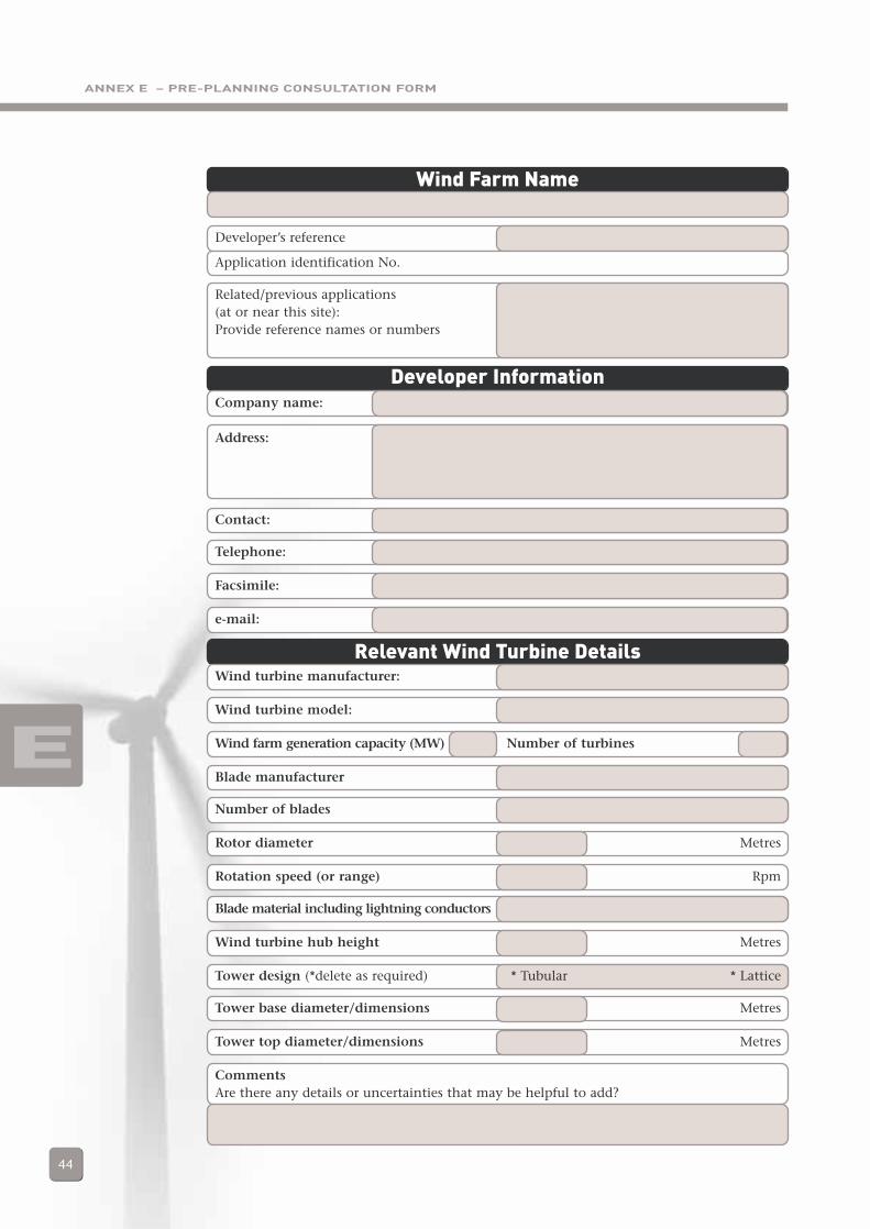
ANNEX E – PRE-PLANNING CONSULTATION FORM
44
E
Wind Farm Name
Developer’s reference
Application identification No.
Related/previous applications (at or near this site):Provide reference names or numbers
Developer InformationCompany name:
Address:
Contact:
Telephone:
Facsimile:
e-mail:
Relevant Wind Turbine DetailsWind turbine manufacturer:
Wind turbine model:
Wind farm generation capacity (MW) Number of turbines
Blade manufacturer
Number of blades
Rotor diameter Metres
Rotation speed (or range) Rpm
Blade material including lightning conductors
Wind turbine hub height Metres
Tower design (*delete as required) * Tubular * Lattice
Tower base diameter/dimensions Metres
Tower top diameter/dimensions Metres
CommentsAre there any details or uncertainties that may be helpful to add?
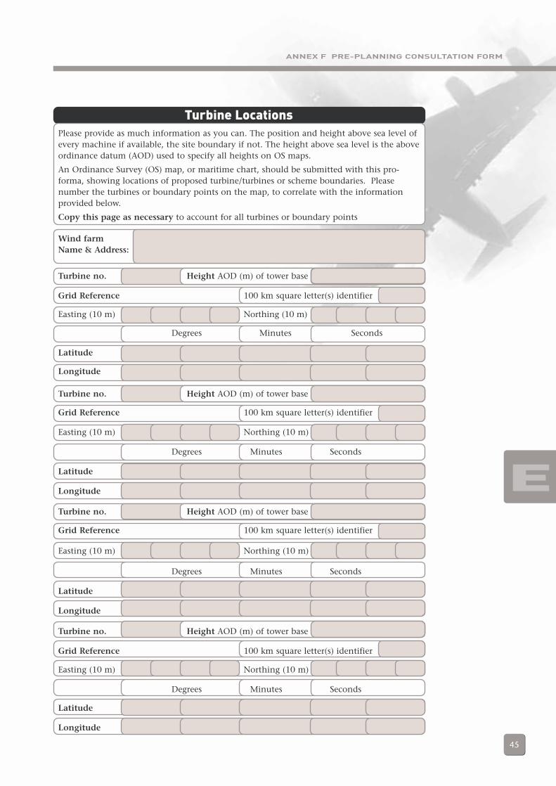
ANNEX F PRE-PLANNING CONSULTATION FORM
45
E
Turbine LocationsPlease provide as much information as you can. The position and height above sea level ofevery machine if available, the site boundary if not. The height above sea level is the aboveordinance datum (AOD) used to specify all heights on OS maps.
An Ordinance Survey (OS) map, or maritime chart, should be submitted with this pro-forma, showing locations of proposed turbine/turbines or scheme boundaries. Pleasenumber the turbines or boundary points on the map, to correlate with the informationprovided below.
Copy this page as necessary to account for all turbines or boundary points
Wind farmName & Address:
Turbine no. Height AOD (m) of tower base
Grid Reference 100 km square letter(s) identifier
Easting (10 m) Northing (10 m)
Degrees Minutes Seconds
Latitude
Longitude
Turbine no. Height AOD (m) of tower base
Grid Reference 100 km square letter(s) identifier
Easting (10 m) Northing (10 m)
Degrees Minutes Seconds
Latitude
Longitude
Turbine no. Height AOD (m) of tower base
Grid Reference 100 km square letter(s) identifier
Easting (10 m) Northing (10 m)
Degrees Minutes Seconds
Latitude
Longitude
Turbine no. Height AOD (m) of tower base
Grid Reference 100 km square letter(s) identifier
Easting (10 m) Northing (10 m)
Degrees Minutes Seconds
Latitude
Longitude
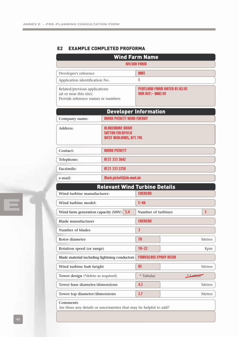
ANNEX E – PRE-PLANNING CONSULTATION FORM
46
E
E2 EXAMPLE COMPLETED PROFORMA
Wind Farm NameWILSON FARM
Developer’s reference 0001
Application identification No. 1
Related/previous applications PENTLAND FARM DATED 01/02/01(at or near this site): OUR REF:- 0002/01Provide reference names or numbers
Developer InformationCompany name: MARK PICKETT WIND ENERGY
Address: BLAKEMORE DRIVESUTTON COLDFIELDWEST MIDLANDS, B75 7RL
Contact: MARK PICKETT
Telephone: 0121 333 3642
Facsimile: 0121 333 2258
e-mail: [email protected]
Relevant Wind Turbine DetailsWind turbine manufacturer: ENERCON
Wind turbine model: E-66
Wind farm generation capacity (MW) 5.4 Number of turbines 3
Blade manufacturer ENERCON
Number of blades 3
Rotor diameter 70 Metres
Rotation speed (or range) 10-22 Rpm
Blade material including lightning conductors FIBREGLASS EPOXY RESIN
Wind turbine hub height 85 Metres
Tower design (*delete as required) * Tubular * Lattice
Tower base diameter/dimensions 4.3 Metres
Tower top diameter/dimensions 2.7 Metres
CommentsAre there any details or uncertainties that may be helpful to add?
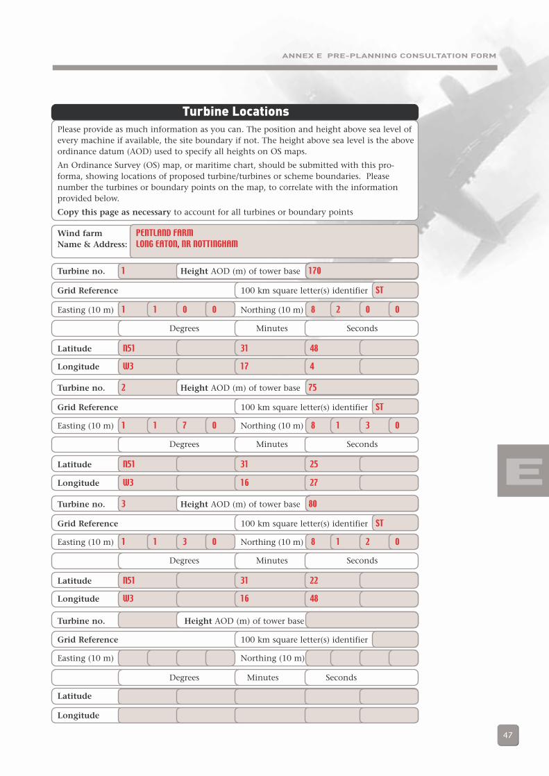
ANNEX E PRE-PLANNING CONSULTATION FORM
47
E
Turbine LocationsPlease provide as much information as you can. The position and height above sea level ofevery machine if available, the site boundary if not. The height above sea level is the aboveordinance datum (AOD) used to specify all heights on OS maps.
An Ordinance Survey (OS) map, or maritime chart, should be submitted with this pro-forma, showing locations of proposed turbine/turbines or scheme boundaries. Pleasenumber the turbines or boundary points on the map, to correlate with the informationprovided below.
Copy this page as necessary to account for all turbines or boundary points
Wind farm PENTLAND FARMName & Address: LONG EATON, NR NOTTINGHAM
Turbine no. 1 Height AOD (m) of tower base 170
Grid Reference 100 km square letter(s) identifier ST
Easting (10 m) 1 1 0 0 Northing (10 m) 8 2 0 0
Degrees Minutes Seconds
Latitude N51 31 48
Longitude W3 17 4
Turbine no. 2 Height AOD (m) of tower base 75
Grid Reference 100 km square letter(s) identifier ST
Easting (10 m) 1 1 7 0 Northing (10 m) 8 1 3 0
Degrees Minutes Seconds
Latitude N51 31 25
Longitude W3 16 27
Turbine no. 3 Height AOD (m) of tower base 80
Grid Reference 100 km square letter(s) identifier ST
Easting (10 m) 1 1 3 0 Northing (10 m) 8 1 2 0
Degrees Minutes Seconds
Latitude N51 31 22
Longitude W3 16 48
Turbine no. Height AOD (m) of tower base
Grid Reference 100 km square letter(s) identifier
Easting (10 m) Northing (10 m)
Degrees Minutes Seconds
Latitude
Longitude
ANNEX F – GLOSSARY
48
Airborne Stand-Off The Airborne STand-Off Radar (ASTOR) is a UK military airborneRadar ground surveillance system designed to provide information
regarding the deployment and movement of enemy forces. It willuse radar technology to obtain high-resolution imagery of staticfeatures and will also identify and track moving vehicles. Anumber of Global Express commercial business jet aircraft, able tooperate above 40,000 ft and which have an endurance in excess ofnine hours, will be modified to carry the radar, air-to-ground datalinks and defensive aids equipment. Imagery gathered will betransmitted in near-real-time to a network of distributed GroundStations deployed with front-line forces. Images will be displayedand analysed within the Ground Stations, ensuring that tacticalcommanders are aware of the latest developments on the ground.The In Service Date will be 2005.
CAP 168 Civil Aviation Publication 168 “Licensing of Aerodromes”.Contact CAA Safety Regulation Group for further information.
CAP 670 Civil Aviation Publication 670 “Air Traffic Services SafetyRequirements”. Contact CAA Directorate of Airspace Policy forfurther information. Also available fromwww.caa.co.uk/docs/33/CAP670_A05.pdf
Doppler Shift When an object is moving radially (that is towards or away from atransmitter), the frequency of the returned echo is shifted from theoriginal frequency by an amount dependent on the radial velocityof the target. This change in frequency is called the DopplerFrequency or Doppler Shift.
Garbling False codes displayed when aircraft are close enough for their SSRresponses to overlap.
Greenhouse Gas Greenhouse gases include any gas in the atmosphere that iscapable, as a result of its particular molecular structure, ofabsorbing infrared radiation or heat. They are called greenhousegases because they behave like glass in a greenhouse, allowingsunlight to pass through but trapping the heat formed andpreventing it from escaping, thereby causing a rise in temperature.Natural greenhouse gases include water vapour or moisture, carbondioxide, methane, nitrous oxide and ozone. The amounts of allthese gases in the atmosphere are now increasing as a result ofman-made processes, such as burning fossil fuels and deforestation.
High Intensity Radio High Intensity Radio Transmission Areas (HIRTAs) areTransmission Areas established to warn aircraft of the presence of high power radio
transmissions, which could seriously interfere with on-boardsystems. Their dimensions are determined by calculating theradio propagation paths and intensities.
F
ANNEX FGlossary

ANNEX F – GLOSSARY
49
Height A number of different terms are used to denote the height of anaircraft. All are based on vertical distance from a given datum:either the ground, sea level or an agreed reference. The normalmeasure used is feet. Whilst an aircraft’s height may therefore beexpressed in different ways, it is its height relative to the height ofa wind turbine above the ground (or sea) that is important in thecontext of this document.
Navigation Aids Systems which aid aeronautical navigation.
Radar Radio Detection and Ranging. A system for detecting the presenceor position or movement of objects by transmitting radio waves,which are reflected back to a receiver.
Radar Clutter Radar returns (echoes) from objects (targets) considered irrelevantto the purpose of the radar.
Radar Masking The masking of aircraft by reflecting or deflecting the radar echoessuch that aircraft flying in the “shadow” of an object are notdetected.
Radar Echo When the radio wave transmitted by a radar is interrupted by anobject part of the energy is reflected back to a radio receiver locatednear the transmitter. This reflection is called an echo and theobject reflecting it is called the target.
Recognised Air The fullest achievable agreed level of identification and trackingPicture of all airborne contacts in the area of interest.
Safeguarding The stakeholders in both civil and military aviation conduct aProcess process aimed to ensure that their needs are not compromised that is
termed “safeguarding”. The formal term “Safeguarding” in associationwith wind turbines is only used for civil purposes; military agencies donot have an equivalent formal term but follow effectively the sameprocedures. For simplicity, the term “safeguarding” in this documentis used to refer to both civil and military processes.
Secondary A radar system comprising a ground-based Surveillance Radar transmitter/receiver which interrogates a compatible unit in an
aircraft (transponder), providing an instant and automatic radaridentification without having to manoeuvre.
Surveillance The systematic observation of aerospace, surface or sub-surfaceareas, places, persons or things, by visual, aural, electronic,photographic or other means.
Tactical Data Link Means of communication, used primarily by the military, fortransmission and receipt of a data messages.
Tactical Training Tactical Training Areas (TTAs) are military training areas whereAreas Operational Low Flying at altitudes below 250 feet minimum
separation distance (msd) is permitted. Within these areas, fast jetaircraft are permitted to fly as low as 100 feet msd. The TTAs arelocated in: northern Scotland, the border areas of northernEngland/southern Scotland, and in central Wales.
F
ANNEX F – GLOSSARY
50
Transponder The airborne receiver/transmitter portion of the SSR system,which receives the interrogation signal from the ground andautomatically replies according to mode and code selected.Modes A and B are used for identification, using a four-digitnumber allocated by air traffic control. Mode C gives automaticaltitude readout from an encoding altimeter.
UK Air Surveillance The UK Air Surveillance and Control System (ASACS)and Control System comprises the surveillance and command and control systems
which are used to detect and identify aircraft approaching, over-flying or leaving the UK and thence to produce a Recognised AirPicture (RAP). The ASACS has three main elements:
– Ground-based radars.– Airborne radars.– Command and Control systems (These systems are used to
provide a composite picture of air activity (the RAP) and todirect responses to any activity that may warrant action).
UK Airspace UK Airspace is divided into 2 main areas, known as FlightInformation Regions, or FIRs, the Scottish FIR, and the LondonFIR. The responsibility for these lies with three centres: theLondon Area and Terminal Control Centre (LATCC) situated atSwanwick, the Scottish Oceanic and Area Control Centre atPrestwick, and the Manchester Area Control Centre (MACC), atManchester Airport.
LATCC covers all airspace over England, Wales and Scotland up to55 degrees North. The region North of this is covered by ScottishFIR. Manchester covers an area from surface to Flight Level 195(Approx. 19,500 feet) in the Manchester area, extending Westtowards Dublin, East to Humberside, South to Birmingham andNorth to the Scottish Border. Manchester also has an extra areawhich covers ‘open’ airspace over the Yorkshire area designated‘Pennine Radar’
For the purposes of controlling Air Traffic in manageable areas,each FIR is further split into ‘sectors’ for which a controller hasresponsibility.
UK Low Flying A system designed to allow the management of military lowSystem flying overland and surrounding overseas areas (extending out to
3nm from the land). It covers the whole of the open airspace ofthe UK and surrounding overseas areas from the surface to 2000feet above ground or sea level.
Wind Farm A collection of wind turbines designed to generate electricity,which is often fed into a grid distribution system.
Wind Turbine A machine for generating electricity from the wind.
F
ANNEX G – LIST OF ACRONYMS
51
AOD Above Ordnance Datum
ASACS Air Surveillance And Control System
ASTOR Airborne Stand-Off Radar
ATC Air Traffic Control
ATS Air Traffic Services
ATSSD Air Traffic Services Standards Department
BWEA British Wind Energy Association
CAA Civil Aviation Authority
CAP Civil Aviation Publication
CNS Communications, navigation and surveillance
D Flying MOD Directorate of Flying, Ministry of Defence
DAP (CAA) Directorate of Airspace Policy (Civil Aviation Authority)
DCSA Defence Communications Systems Agency
DE Defence Estates
DEFRA Department for Environment, Food and Rural Affairs
DfT Department for Transport
DPA Defence Procurement Agency
DTI Department of Trade and Industry
DTLR Department of Transport, Local Government and the Regions
EM Electromagnetic
EWTR Electronic Warfare Tactics Range
HIRTA High Intensity Radio Transmission Area
HQ 2 Gp MOD Headquarters No. 2 Group, Ministry of Defence
HQSTC MOD Headquarters Strike Command, Ministry of Defence
ILS Instrument Landing System
LF Low Flying
LFS Low Flying System
LOS Line of Sight
LPA Local Planning Authority
LTCC London Terminal Control Centre
m Metre(s)
m/s Metres per second
Met Meteorological
MOD Ministry Of Defence
G
ANNEX GList of Acronyms

ANNEX G – LIST OF ACRONYMS
52
msd Minimum Separation Distance
MTI Moving Target Indicator
MW Megawatt
NAI Non-Automatic Initiation
NATS National Air Traffic Services
Navaids Navigation Aids
NFFO Non-Fossil Fuel Obligation
nm Nautical mile(s)
NPPG6 National Planning Policy Guideline 6
ODPM Office of the Deputy Prime Minister
OFGEM Office of Gas and Electricity Markets
OS Ordnance Survey
PAN Planning Advice Note
PIU Performance and Innovation Unit
PPG22 Planning Policy Guidance Note 22
PPW Planning Policy Wales
RAP Recognised Air Picture
RO Renewables Obligation
rpm Revolutions per minute
SRG Safety Regulation Group
SSR Secondary Surveillance Radar
STAR Standard Arrival
SID Standard Instrument Departure
TTA Tactical Training Area
TAN8 Technical Advice Note 8
TWh Terawatt-hours
G

ANNEX H – CONTACT ADDRESSES
53
The Airport Operators’ AssociationBirdcage WalkLondonSW1H 9JJwww.aoa.org.uk
British Wind Energy AssociationRenewable Energy House1 Aztec RowBerners RoadLondonN1 0PWTelephone 020 7689 1960 e-mail [email protected]
Civil Aviation AuthorityDirectorate of Airspace PolicyCAA House45-59 KingswayLondonWC2B 6TEAndy Knill (Telephone 020 7453 6530; e-mail: [email protected])www.caa.co.uk/dap
Civil Aviation AuthoritySafety Regulation GroupAviation HouseGatwick Airport SouthWest SussexRH6 0YRAndy Sneddon (Telephone 01293 573432;e-mail [email protected])Enquiries 01293 567171www.caa.co.uk/srg
Department for Environment, Food and Rural AffairsNobel House17 Smith SquareLondonSW1P 3JRwww.defra.gov.uk
Department of Trade and Industry1 Victoria StreetLondonSW1H 0ETRobert Lilly (Telephone 020 7215 6122; e-mail [email protected])
Keith Welford (Telephone 020 7215 0478; e-mail [email protected])www.dti.gov.uk/energy/leg_and_reg/consents/index.shtml
DTI’s Renewable Energy HelplineB329 HarwellOxonOX11 0QJTel: 01235 432450e-mail: [email protected]/renewable/index.html
Department for TransportGreat Minster House76 Marsham StreetLondonSW1P 4DRwww.aviation/dft.gov.uk
Ministry of Defence (Defence Estates)Blakemore DriveSutton ColdfieldWest MidlandsB75 7RLMark Pickett (Telephone 0121 311 3847; e-mail: [email protected])www.defence-estates.mod.uk
National Air Traffic Services1 Kemble StreetLondonWC2B 4APwww.nats.co.uk
NATS En-Route LimitedNav, Spectrum & SurveillanceSpectrum HouseGatwick Airport SouthGatwickWest SussexRH6 0LG
NATS (Services) LimitedTechnical SafeguardingRoom 101Control Tower BuildingHeathrow AirportHounslowMiddlesexTW6 1JJ
H
ANNEX HContact Addresses

ANNEX H – CONTACT ADDRESSES
54
National Assembly for WalesPlanning DivisionCathays ParkCardiffCF10 3NQwww.wales.gov.uk/subiplanning/index.htm
Northern Ireland Planning ServiceAgencyClarence CourtAdelaide StreetBelfastBT2 8GBwww.doeni.gov.uk/planning
Office of the Deputy Prime MinisterEland HouseBressenden PlaceLondonSW1E 5DUOfwww.planning.odpm.gov.uk
Office of Gas and Electricity Markets(OFGEM)9 Millbank Regents CourtLondon 70 West Regent StreetSW1P 3GE Glasgow
G2 2QZwww.ofgem.gov.uk
Performance and Innovation Unit4th FloorAdmiralty ArchThe MallLondonSW1A 2WHwww.piu.gov.uk
Scottish ExecutiveEnterprise and Lifelong Learning DeptEnergy DivisionMeridian CourtCadogan StreetGlasgowG2 6ATwww.scotland.gov.uk/planning
Scottish ExecutiveDevelopment DepartmentPlanning and Building StandardsVictoria QuayEdinburghEH6 6QQwww.scotland.gov.uk/planning
H

ANNEX I – STAKEHOLDER FEEDBACK PROFORMA
55
I
ANNEX IStakeholder Feedback Proforma
Name, organisation Comment (including section number commented on,and contact details where appropriate)
When completed, this form should be sent to:
Fiona BrocklehurstFuture Energy SolutionsAEA Technology plcHarwellDidcotOxfordshireOX11 0QJ
Or alternatively, send an e-mail titled ‘Feedback on wind energy and aviation interests -interim guidelines’ and containing your name, organisation and contact details to:

Department of Trade and Industry
DTI/Pub URN 02/1287