Embed Size (px)
Citation preview
Windsor Bridge ReplacementRoads and Maritime
Vegetation Management Plan
IA98200-NEM-RP-313 | Rev 0
June 2018
Vegetati on Mana ge ment PlanRoads and Mari time
Vegetation Management Plan
IA98200-NEM-RP-313 ii
ContentsGlossary/Abbreviations ...........................................................................................................................51. Introduction ..................................................................................................................................71.1 Background and need ....................................................................................................................71.2 Aim and Objectives of the Vegetation Management Plan ................................................................81.3 Scope ............................................................................................................................................82. Existing environmental conditions .............................................................................................92.1 Landscape context .........................................................................................................................92.2 Vegetation communities ............................................................................................................... 103. Layout of the proposed riparian corridor.................................................................................. 133.1 Riparian corridor width ................................................................................................................. 133.2 Management zones ...................................................................................................................... 153.3 Delineation of revegetation areas ................................................................................................. 184. Site preparation .......................................................................................................................... 214.1 Controlling access ........................................................................................................................ 214.2 Weed control ................................................................................................................................ 214.3 Stabilisation and weed suppression .............................................................................................. 214.4 In-stream Debris and Snags ......................................................................................................... 224.5 Soil preparation ............................................................................................................................ 22
4.5.1 Soil scalping ................................................................................................................................. 22
4.5.2 Ripping and scarification .............................................................................................................. 224.6 Educational signage ..................................................................................................................... 234.7 Phytophthora prevention .............................................................................................................. 235. Revegetation methods ............................................................................................................... 245.1 Weed removal .............................................................................................................................. 24
5.1.1 Hand removal and cultivation ....................................................................................................... 24
5.1.2 Mulching ...................................................................................................................................... 25
5.1.3 Cut and paint with herbicide ......................................................................................................... 25
5.1.4 Scrape and paint with herbicide .................................................................................................... 25
5.1.5 Stem injection, frilling or chipping with herbicide ........................................................................... 25
5.1.6 Foliar spot spraying with herbicide ................................................................................................ 25
5.1.7 Revegetation ................................................................................................................................ 26
5.1.8 Tubestock planting ....................................................................................................................... 266. Plant species selection .............................................................................................................. 276.1 Selection criteria .......................................................................................................................... 27
6.1.1 Provenance .................................................................................................................................. 27
6.1.2 Species diversity .......................................................................................................................... 27
6.1.3 Succession and nitrogen fixation .................................................................................................. 286.2 Recommended species mix and planting density .......................................................................... 286.3 Seed collection methods .............................................................................................................. 28
6.3.1 Seed collection permits and licences ............................................................................................ 29
Vegetation Management Plan
IA98200-NEM-RP-313 iii
7. Plant propagation ....................................................................................................................... 308. Plant installation guidelines ...................................................................................................... 318.1 Direct seeding .............................................................................................................................. 318.2 Tubestock planting ....................................................................................................................... 318.3 Plant spacing ............................................................................................................................... 318.4 Timing .......................................................................................................................................... 318.5 Plant protection ............................................................................................................................ 328.6 Weed control and mulching .......................................................................................................... 328.7 Watering ...................................................................................................................................... 329. Planting area maintenance ........................................................................................................ 339.1 Short-term maintenance ............................................................................................................... 33
9.1.1 Weed control ................................................................................................................................ 33
9.1.2 Irrigation ....................................................................................................................................... 339.2 Long-term maintenance ............................................................................................................... 33
9.2.1 Weed control ................................................................................................................................ 33
9.2.2 Fertilisers ..................................................................................................................................... 33
9.2.3 Pests and diseases ...................................................................................................................... 33
9.2.4 Plant protection ............................................................................................................................ 34
9.2.5 Pruning ........................................................................................................................................ 34
9.2.6 Replacement planting................................................................................................................... 34
9.2.7 Thinning ....................................................................................................................................... 34
9.2.8 Deep Watering ............................................................................................................................. 34
9.2.9 Rubbish Removal ......................................................................................................................... 34
9.2.10 Maintenance Inspections .............................................................................................................. 349.3 Revegetation timeline ................................................................................................................... 3510. Implementation schedule and indicative cost analysis............................................................ 3710.1 Implementation schedule.............................................................................................................. 3710.2 Roles and responsibilities ............................................................................................................. 3710.3 Indicative cost analysis ................................................................................................................. 3811. Monitoring, reporting and success criteria ............................................................................... 4011.1 Monitoring procedure ................................................................................................................... 4011.2 Reporting ..................................................................................................................................... 4311.3 Success criteria ............................................................................................................................ 4312. References ................................................................................................................................. 44
Appendix A. Recommended species mix for revegetationAppendix B. Recommended planting scheduleAppendix C. Photographic monitoring points
Vegetation Management Plan
5
Glossary/Abbreviations
ASS Acid sulfate soilsCEMP Construction Environmental Management PlanCompliance audit Verification of how implementation is proceeding with respect to an
environmental management plan (EMP) (which incorporates therelevant approval conditions).
CoA Conditions of approvalDoE Commonwealth Department of the EnvironmentDP&E NSW Department of Planning and EnvironmentDPI NSW Department of Primary IndustriesEcologically sustainabledevelopment
Using, conserving and enhancing the community’s resources so that theecological processes on which life depends are maintained and the totalquality of life now and in the future, can be increased (Council ofAustralian Governments, 1992).
EEC Endangered Ecological CommunitiesEIS Environmental Impact StatementEMP Environmental Management PlanEMS Environmental Management SystemEnvironmental aspect Defined by AS/NZS ISO 14001:2004 as an element of an organisation’s
activities, products or services that can interact with the environment.Environmental impact Defined by AS/NZS ISO 14001:2004 as any change to the environment,
whether adverse or beneficial, wholly or partially resulting from anorganisation’s environmental aspects.
Environmental incident An unexpected event that has, or has the potential to, cause harm tothe environment and requires some action to minimise the impact orrestore the environment.
Environmental objective Defined by AS/NZS ISO 14001:2004 as an overall environmental goal,consistent with the environmental policy, that an organisation sets itselfto achieve.
Environmental policy Statement by an organisation of its intention and principles forenvironmental performance.
Environmental target Defined by AS/NZS ISO 14001:2004 as a detailed performancerequirement, applicable to the organisation or parts thereof, that arisesfrom the environmental objectives and that needs to be set and met inorder to achieve those objectives.
EnvironmentalRepresentative (ER)
A suitably qualified and experienced person independent of Projectdesign and construction personnel employed for the duration ofconstruction. The principal point of advice in relation to all questions andcomplaints concerning environmental performance.
EP&A Act Environmental Planning and Assessment Act 1979EPA Environment Protection AuthorityEPBC Act Environment Protection and Biodiversity Conservation Act 1999EPL Environment Protection Licence under the Protection of the
Environment Operations Act 1997.Minister, the Minister for Planning and InfrastructureNon-compliance Failure to comply with the requirements of the Project approval or any
applicable license, permit or legal requirements.

Vegetation Management Plan
6
Non-conformance Failure to conform to the requirements of Project system documentationincluding this CEMP or supporting documentation.
NOW NSW Office of WaterOEH NSW Office of Environment and HeritageOOH Out of Hours (works outside standard work hours)SCMP Strategic Conservation Management PlanSPIR Submissions Preferred Infrastructure ReportPoEO Act Protection of the Environment Operations Act 1997Project, the The Windsor Bridge Replacement ProjectRMS Roads and Maritime ServicesSAP Sensitive Area PlansSOC Statement of Commitments
Secretary Secretary of the Department of Planning and EnvironmentSSI State Significant InfrastructureThompson SquareConservation Area
Also known as the Thompson Square Precinct, this is the area ofThompson Square listed on the State Heritage Register of NSW. One ofthe oldest public squares in Australia, constructed in 1811. Surroundingbuildings were constructed between 1815 and 1880 in the colonialGeorgian style. The Square consists of George Street, Bridge Street,Thompson Square and The Terrace.

Vegetation Management Plan
7
1. IntroductionThis Vegetation Management Plan describes the methods and standards for revegetation required as part ofthe Windsor Bridge Replacement Project at Windsor in the Hawkesbury Local Government Area (LGA) (referFigure 1-1).
1.1 Background and need
The Windsor Bridge Replacement Project (the Project), involves replacement of an existing bridge with a newroad bridge over the Hawkesbury River at Windsor being delivered by NSW Roads and Maritime Services.
The Project has been assessed as State Significant Infrastructure under Part 5.1 of the Environmental Planningand Assessment Act 1979 (EP&A Act).
An environmental impact statement (EIS) Windsor Bridge Replacement Project Environmental ImpactStatement was prepared by Sinclair Knight Merz in November 2012 for Roads and Maritime Services. The EISwas on public exhibition until 17 December 2012.
A submissions report (and preferred infrastructure report) was finalised in May 2013 and addressed allstakeholder submissions received during the EIS exhibition period. The Project was subsequently approved inDecember 2013 by the Minister for Planning and Infrastructure.
This Vegetation Management Plan (VMP) has been prepared to satisfy Director General’s Conditions ofApproval (CoA) and the associated Statement of Commitments (SOCs) for the Project (see Table 1-1). TheVMP was developed with consideration to the Project Urban Design and Landscape Detailed Design Report,and the Strategic Conservation Management Plan (SCMP), which includes policy on tree plantings (SpackmanMossop and Michaels 2017).
Table 1-1 Director General’s Condition of Approval
No. Requirement Document ReferenceC34 A riparian corridor consisting of vegetation from the relevant local
native vegetation communities shall be established along theHawkesbury River bank areas disturbed by the project with theexception of those areas required for scour protection for the safety ofthe bridge. The riparian corridor is to be consistent with the ControlledActivities on Waterfront Land: Guidelines for Riparian Corridors onWaterfront Land (NSW Office of Water, July 2012b).
Windsor Bridge ReplacementUrban design and landscapeplan and Landscape DesignDrawings
Chapter 3
C35 A Vegetation Management Plan (VMP) is to be prepared consistentwith the Controlled Activities on Waterfront Land: Guidelines forVegetation Management Plan on Waterfront Land (NSW Office ofWater, July 2012a) that demonstrates the protection of remnant nativeriparian vegetation and the rehabilitation of the riparian corridor. TheVMP must be complied with.
This plan
C36 Seed sources used for the rehabilitation of the riparian corridor are tobe from local native botanical provenance where possible.
Section 6.3
C37 A minimum two year monitoring and maintenance period is requiredfor the riparian zone commencing after final planting, or until such timeas a minimum 80 per cent survival rate of each species planted and amaximum 5 per cent weed cover for the treated riparian corridor isachieved. The monitoring program is to include weed controlmonitoring.
Chapter 9 and Chapter 11
Vegetation Management Plan
8
The Project is being delivered in three stages with indicative timeframes for completion outlined below:
· Stage 1 – ‘before pre-construction’ activities (June 2016 to December 2017)
· Stage 2 – pre-construction and construction of replacement bridge and ancillary works (March 2018 to
December 2020)
· Stage 3 – demolition of existing bridge and ancillary works (Nov 2020 to Feb 2021).
The site comprises highly developed and highly degraded landscapes along the banks of the HawkesburyRiver, with remnants of Riparian Forest, Alluvial Woodland, and Shale Plains Woodland within the vicinity of theproposed project. These vegetation communities are considered threatened under the Threatened SpeciesConservation Act 1995.
1.2 Aim and Objectives of the Vegetation Management Plan
The general objective of the revegetation at the site will be to enhance the condition of vegetation in the ripariancorridor through supplementary planting. Revegetation will be conducted in a manner that will maximisebiodiversity values and minimise undesirable outcomes such as proliferation of weed species. Revegetation willaim to protect existing remnant bushland as per the MCoA.
In addition to enhancing the riparian corridor a key project objective is to retain and where possible improve,views to important landmarks in particular the Hawkesbury River, Thompson Square and the historic buildingsaround Thompson Square. These views have cultural significance to the existing landscape character ofWindsor and its surrounds and are detailed in Chapter 7 of the EIS.
This plan aims to be consistent with the accepted best practice techniques and guidelines outlined inRecovering Bushland on the Cumberland Plain: Best Practice guidelines for the Management and Restorationof Bushland (Department of Environment and Conservation 2005) and Guidelines for vegetation managementplans on waterfront land (NSW Office of Water, July 2012a).
1.3 Scope
This VMP includes methods for revegetation and maintenance of plantings, site preparation methods, andguidance on appropriate plant species selection and propagation for areas disturbed by the Project. Monitoringand success criteria are also provided. The roles and responsibilities for parties involved in the revegetationproject are determined, an indicative cost analysis for the revegetation works is also provided.
Disturbed areas will be revegetated progressively during the construction period which will be followed by a 2year monitoring and maintenance period after final planting. After this period, subject to meeting theperformance criteria, revegetated areas will be handed over to Hawkesbury City Council (HCC) through a formalinspection process. The VMP will be handed over to council with information incorporated into council’s existingand Land Management Plans.
Vegetation Management Plan
9
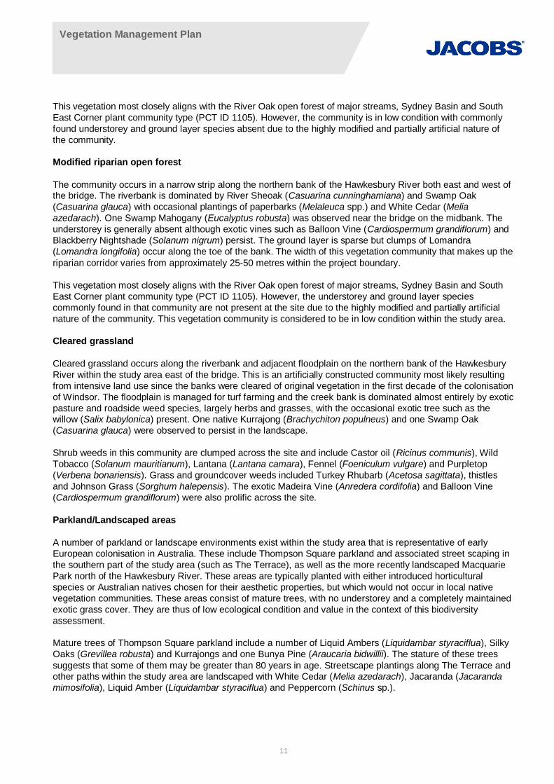
2. Existing environmental conditionsThe proposed development is located in the developed central portion of Windsor in the Hawkesbury LocalGovernment Area (LGA) (refer Figure 2-1). The site to be re-vegetated consists of the riparian corridor, nearbyremnant vegetation and cleared areas surrounding the site.
The construction footprint is wholly located within the Cumberland Plain Sub-region of the Sydney BasinBioregion situated on the east coast of NSW. While the Bioregion is one of the most species-diverse in thestate, the Cumberland Plain sub-region is considered to be the most highly developed and as a result, the mosthighly degraded.
The Hawkesbury River runs north-easterly through the site and is located in the South Creek sub-catchment ofthe Hawkesbury-Nepean catchment. The sub catchment is heavily degraded as a result of historical vegetationclearance and urbanisation, with riparian zones often infested with woody weeds. The area around the site isrepresentative of the degraded environment of the broader sub-catchment.
2.1 Landscape context
The physical environmental features of the Sydney Basin Bioregion as identified in Mitchell (2003) aresummarised in Table 3-1. The proportion of cleared estimates for each landscape is derived from the overcleared landscapes database (DECCW 2010).
The NSW Landscapes coverage is a state-wide map of landscapes, compiled using existing resources anddescribing land attributes considered to drive ecosystem processes (Mitchell, 2003). Definition of thelandscapes emphasises geologic, geomorphic and pedologic factors. In the Eastern and Central Divisions of thestate, geology and topography were emphasised. The study area traverses the floodplain of the HawkesburyRiver and the low hills typical of the river terrace landscape (Mitchell, 2003).
Table 2-1 Mitchell Landscapes in the study area
Mitchell (2003)ecosystems
Landscape characteristics (geomorphic, pedologic and vegetation) Percentagecleared*
Hawkesbury-NepeanTerraceGravels
Three levels of river terrace dating to the Tertiary period. General elevation20 to 45 m, local relief 10 m. Planar, poorly drained terraces with harshtexture-contrast soils and heavy clays in swamps and cut-off meanders. Inplaces deep sands of crevasse splays support Scribbly Gum (Eucalyptussclerophylla), Narrow-leaved Apple (Angophora bakeri) and Old ManBanksia (Banksia serrata) on podsols with adjacent sedgelands. Most clay-based soils (harsh texture-contrast profiles) are very gravelly and carryBroadleaved Ironbark (Eucalyptus fibrosa ssp. fibrosa) and Narrow-leavedIronbark (Eucalyptus crebra), Grey Box (Eucalyptus moluccana),paperbarks (Melaleuca sp.) and Drooping Red Gum (Eucalyptusparramattensis). Several vegetation communities are now rare, especiallyon the Pliocene/Pleistocene sand body with podsol soil profiles at AgnesBanks.
67%
Hawkesbury-NepeanChannels andFloodplains
Meandering channel and moderately wide floodplain of the Hawkesburyand Nepean rivers on Quaternary sand and gravel. Sand is dominantupstream of the Warragamba River junction, general elevation 0 to 20 m,local relief <10 m. Undifferentiated alluvial sand to poorly structuredgradation profiles of sandy loam or clay loam. Forests on the river flatsinclude Blue Box (Eucalyptus baueriana), Broad-leaved Apple (Angophorasubvelutina), Manna Gum (Eucalyptus viminalis), River Peppermint(Eucalyptus elata) in upstream sectors and dominated by River Oak(Casuarina cunninghamiana) possibly originally with rainforest speciessuch as White Cedar (Melia azedarach) in the lower sectors. Common
79%
Vegetation Management Plan
10
Mitchell (2003)ecosystems
Landscape characteristics (geomorphic, pedologic and vegetation) Percentagecleared*
Reed (Phragmites australis), Cumbungi (Typha orientalis) and otheraquatic plants are found in the river. Deep organic loams and loamy sandson floodplain with river flat forest of Sydney Blue Gum (Eucalyptussaligna), Round-leaved Gum (Eucalyptus deanei), Forest Red Gum(Eucalyptus tereticornis), Cabbage Gum (Eucalyptus amplifolia), Broad-leaved Apple, Rough-barked Apple (Angophora floribunda) and River Oak.Water Gum occurs (Tristaniopsis laurina) in protected channel sections.Large swamps and lagoons on the floodplain and in tributary streamsbelow Richmond dammed by levees on the main stream support Tall SpikeRush (Eleocharis sphacelata), Juncus sp., Melaleuca sp., andLepidosperma sp. Below Pitt Town the river is tidal and Swamp Oak(Casuarina glauca), Common Reed, River Mangrove (Aegicerascorniculatum), Grey Mangrove (Avicennia marina) and limited salt marshare found on the muddy sands of the inter-tidal zone.
2.2 Vegetation communities
The NSW National Parks and Wildlife Service conducted a vegetation mapping project for the Cumberland Plainin western Sydney from 1997 – 2002 (NPWS, 2002) which covered the current study area. This vegetationmapping was ground-truthed and refined during ecological surveys undertaken for the EIS (SKM, 2012). Table2-1 lists the vegetation communities present within the study area and their distribution is presented in Figure 2-1. Riparian vegetation in the study area is currently composed of one plant community type; River Oak openforest of major streams, Sydney Basin and South-East Corner (PCT ID 1105), which is present in two forms. Adescription of vegetation in the study area has been taken from the Flora and Fauna Working Paper (SKM2010) and is provided below.
Table 2-2 Vegetation communities in the study area
Vegetation Community(NPWS 2002)
Plant community type Condition Area to beimpacted (ha)
Riparian Casuarina openforest
River Oak open forest of major streams, SydneyBasin and South-East Corner (PCT ID 1105)
Low 0.1
Modified riparian openforest (highly modified)
River Oak open forest of major streams, SydneyBasin and South-East Corner (PCT ID 1105)
Low 0.65
Cleared grassland N/A Low 0.9
Parkland/landscapedareas
N/A Low 0.3
Riparian Casuarina open forest
The community occurs in a narrow strip along the southern bank of the Hawkesbury River and bordered by thefootpath of The Terrace which is landscaped with White Cedar (Melia azedarach), Jacaranda (Jacarandamimosifolia), Liquid Amber (Liquidambar styraciflua) and Peppercorn (Schinus sp.). The riverbank is dominatedby River Sheoak (Casuarina cunninghamiana) and Swamp Oak (Casuarina glauca) with White Cedar (Meliaazedarach) along the mid-bank and higher. Occasional eucalypts occur along the mid bank and the communityis generally of low condition with a moderately dense but weedy understory including Green Cestrum (Cestrumparqui) interspersed with paperbarks (Melaleuca sp.) and wattles (Acacia sp.). The ground layer is sparse butpockets of vegetation are dominated by exotic species including Trad (Tradescantia fluminensis). The width ofthis vegetation community that makes up the riparian corridor varies from approximately 15-30 metres within theproject boundary.
Vegetation Management Plan
11
This vegetation most closely aligns with the River Oak open forest of major streams, Sydney Basin and SouthEast Corner plant community type (PCT ID 1105). However, the community is in low condition with commonlyfound understorey and ground layer species absent due to the highly modified and partially artificial nature ofthe community.
Modified riparian open forest
The community occurs in a narrow strip along the northern bank of the Hawkesbury River both east and west ofthe bridge. The riverbank is dominated by River Sheoak (Casuarina cunninghamiana) and Swamp Oak(Casuarina glauca) with occasional plantings of paperbarks (Melaleuca spp.) and White Cedar (Meliaazedarach). One Swamp Mahogany (Eucalyptus robusta) was observed near the bridge on the midbank. Theunderstorey is generally absent although exotic vines such as Balloon Vine (Cardiospermum grandiflorum) andBlackberry Nightshade (Solanum nigrum) persist. The ground layer is sparse but clumps of Lomandra(Lomandra longifolia) occur along the toe of the bank. The width of this vegetation community that makes up theriparian corridor varies from approximately 25-50 metres within the project boundary.
This vegetation most closely aligns with the River Oak open forest of major streams, Sydney Basin and SouthEast Corner plant community type (PCT ID 1105). However, the understorey and ground layer speciescommonly found in that community are not present at the site due to the highly modified and partially artificialnature of the community. This vegetation community is considered to be in low condition within the study area.
Cleared grassland
Cleared grassland occurs along the riverbank and adjacent floodplain on the northern bank of the HawkesburyRiver within the study area east of the bridge. This is an artificially constructed community most likely resultingfrom intensive land use since the banks were cleared of original vegetation in the first decade of the colonisationof Windsor. The floodplain is managed for turf farming and the creek bank is dominated almost entirely by exoticpasture and roadside weed species, largely herbs and grasses, with the occasional exotic tree such as thewillow (Salix babylonica) present. One native Kurrajong (Brachychiton populneus) and one Swamp Oak(Casuarina glauca) were observed to persist in the landscape.
Shrub weeds in this community are clumped across the site and include Castor oil (Ricinus communis), WildTobacco (Solanum mauritianum), Lantana (Lantana camara), Fennel (Foeniculum vulgare) and Purpletop(Verbena bonariensis). Grass and groundcover weeds included Turkey Rhubarb (Acetosa sagittata), thistlesand Johnson Grass (Sorghum halepensis). The exotic Madeira Vine (Anredera cordifolia) and Balloon Vine(Cardiospermum grandiflorum) were also prolific across the site.
Parkland/Landscaped areas
A number of parkland or landscape environments exist within the study area that is representative of earlyEuropean colonisation in Australia. These include Thompson Square parkland and associated street scaping inthe southern part of the study area (such as The Terrace), as well as the more recently landscaped MacquariePark north of the Hawkesbury River. These areas are typically planted with either introduced horticulturalspecies or Australian natives chosen for their aesthetic properties, but which would not occur in local nativevegetation communities. These areas consist of mature trees, with no understorey and a completely maintainedexotic grass cover. They are thus of low ecological condition and value in the context of this biodiversityassessment.
Mature trees of Thompson Square parkland include a number of Liquid Ambers (Liquidambar styraciflua), SilkyOaks (Grevillea robusta) and Kurrajongs and one Bunya Pine (Araucaria bidwillii). The stature of these treessuggests that some of them may be greater than 80 years in age. Streetscape plantings along The Terrace andother paths within the study area are landscaped with White Cedar (Melia azedarach), Jacaranda (Jacarandamimosifolia), Liquid Amber (Liquidambar styraciflua) and Peppercorn (Schinus sp.).
Vegetation Management Plan
12
Figure 2-1 Existing vegetation communities and key sightlines 1
1 Scour protection design is detailed in drawing set NB98005-ECC-DG-0901-0955

Vegetation Management Plan
13
3. Layout of the proposed riparian corridorDeveloping the layout of the site involves first identifying and delineating the extent of the riparian corridor withinthe study area. Riparian land is any land that adjoins or directly influences a body of water and includes:
· the land immediately alongside small creeks and rivers, including the river bank itself
· gullies and dips which sometimes run with water
· areas surrounding lakes
· wetlands and river floodplains which interact with the river in times of flood.
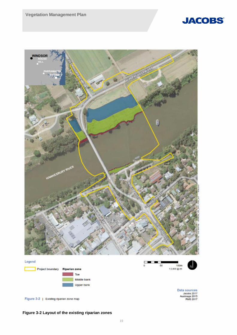
In accordance with CoA C34, a riparian corridor consisting of vegetation from the relevant local nativevegetation communities shall be established along the Hawkesbury River bank areas disturbed by the projectwith the exception of those areas required for scour protection for the safety of the bridge. Using the documentGuidelines for riparian corridors on waterfront land (NSW Office of Water 2012b), the distribution of the existingriparian corridor within the study area has been identified and described (see Figure 3-2).
3.1 Riparian corridor width
Identifying the extent of the riparian corridor on the site is key to ensuring its protection during the constructionand future operation of the distribution centre. The riparian corridor consists of:
· the channel which comprises the bed and banks of the watercourse (to the highest bank)
· the vegetated riparian zone (VRZ) adjoining the channel.
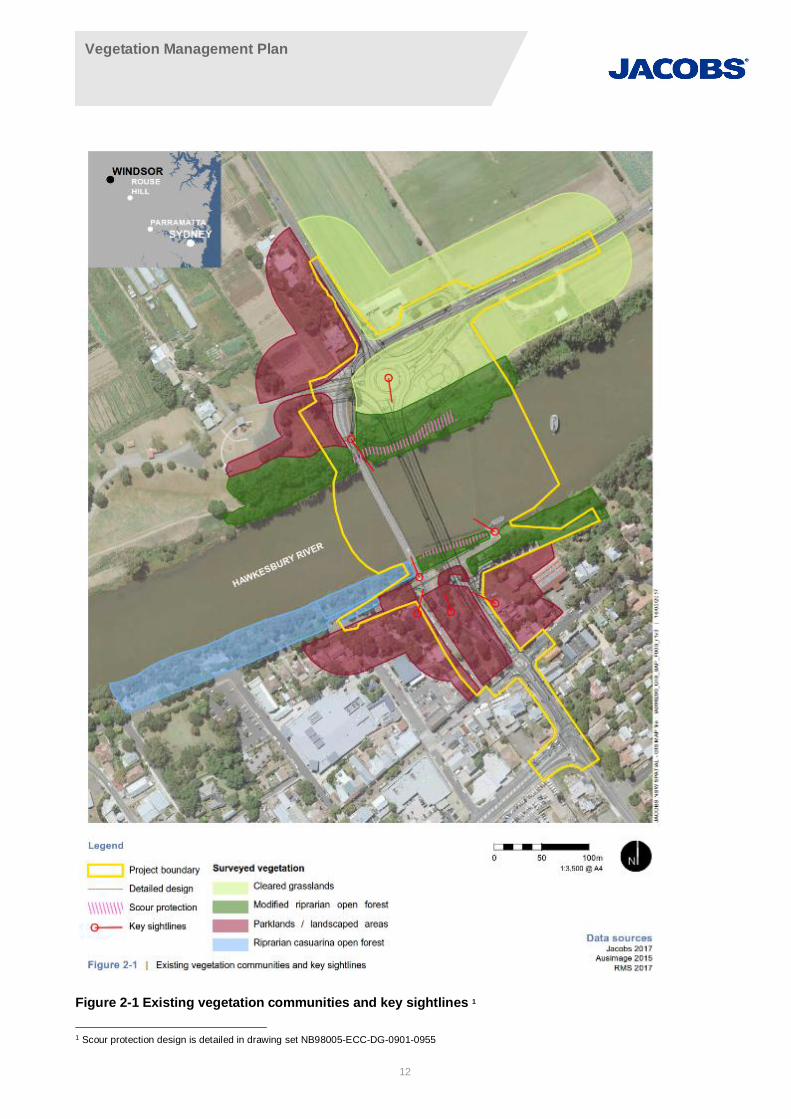
Figure 3-1 illustrates a cross section of a typical riparian corridor, showing the boundaries of the different zonesand the typical plant species that are required to make up these zones. In reality however, the channel will notalways be this well-defined and some zones may be absent. The Office of Water recommends a VRZ widthbased on watercourse order as classified under the Strahler System of ordering watercourses. The Guidelinesfor riparian corridors on waterfront land (NSW Office of Water 2012b) stipulate that, as this section of theHawkesbury River is 4th order stream (Strahler, 1952), a 40 metre VRZ is required.
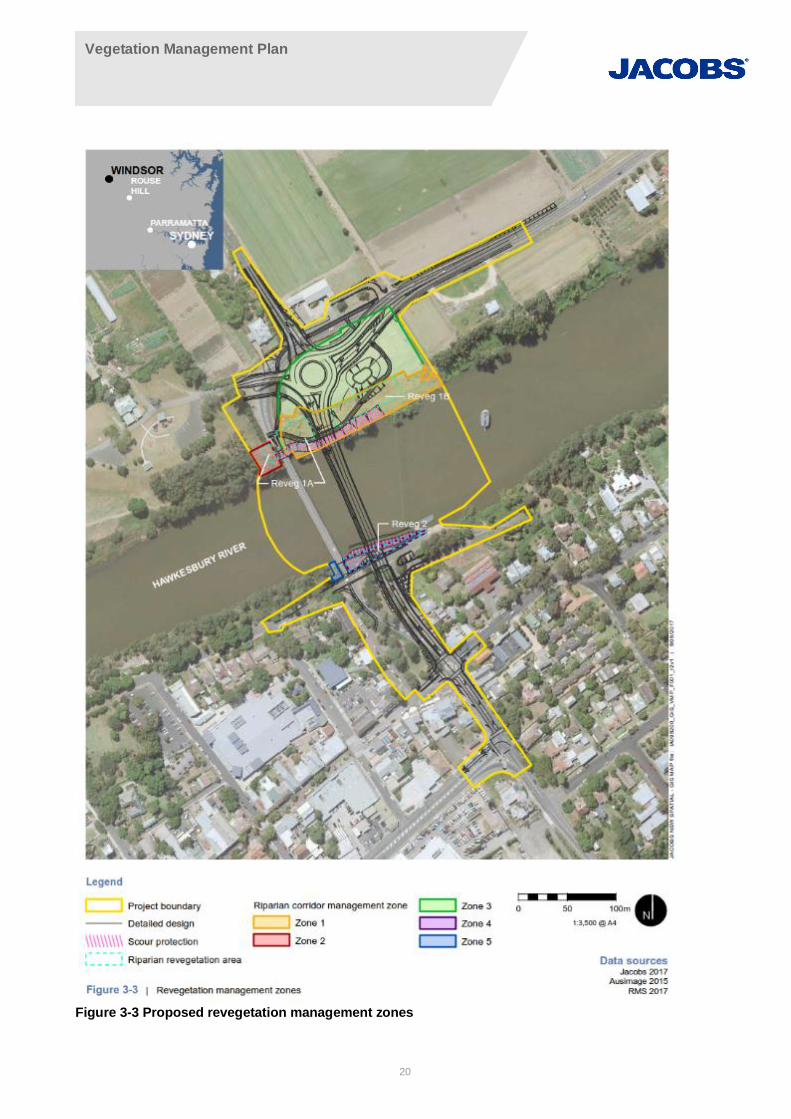
Due to a history of disturbance and the development of infrastructure close to the Hawkesbury River, theriparian corridor in the study area is highly modified, fragmented and varies from approximately 15 to 50 metres.Although there is no obvious delineation of the different riparian zones based on vegetation type, Figure 3-2displays the current extent of the riparian corridor in the study area, separating the zones based on area andslope. The 40 metre VRZ width guideline (NSW Office of Water 2012b) has been applied to the corridor,however this is not achievable across much of the site due to restrictions imposed by existing and plannedinfrastructure. This will continue to be a limiting constraint to the design and construction of the new VRZ. Thebridge design, bike paths, scour protection and existing infrastructure to be retained will all limit the physicalextent of the riparian corridor. Figure 3-3 displays the proposed new VRZ extent and zones of revegetation.Although the proposed VRZ will not satisfy the NSW Office of Water (2012b) guidelines on width, it does onlyinvolve work within “areas disturbed by the project” (CoA C34) and will significantly improve the current ripariancorridor, which in many zones is largely absent.
Vegetation Management Plan
14
Figure 3-1 Typical riparian cross section
Vegetation Management Plan
15
Vegetation in the riparian corridor is currently highly modified and dominated by exotic groundcover speciesacross much of the study area. Areas lacking an intact canopy will require weed removal and planting to re-establish a functioning VRZ. Vegetation to be retained and areas of proposed revegetation as part of the projectare shown in Figure 3-3. Table 3-1 provides a summary of planting constraints applicable to different zoneswithin the riparian corridor adjacent to the project area.
Table 3-1 Planting constraints in the different riparian zones
River bank Riparian corridor zones and riparian planting constraints
Stream Toe Middle Bank Upper Bank
NorthernAs the HawkesburyRiver is classified as a4th order stream,prone to frequentflooding events andnot ephemeral innature no instreamplanting is proposed
Scour protection willbe installed along thetoe. Pockets ofriparian planting willbe interspersed withinthe scour protectionto assist in reducingthe visual impact ofthe scour protectionmaterial
Scour protection willbe predominantlyinstalled in the middlebank zone. Pocketsof riparian plantingwill be interspersedwithin the scourprotection.
The upper bankconsists of clearedgrassland andparkland. It isproposed to maintaina parkland area witha selection of plantedrepresentative nativeriparian species.
Southern As above Scour protection willbe installed along thetoe
Riparian planting willbe provided within themiddle bank
There is no definedupper bank zone withmodified parklandand car park present.
3.2 Management zones
Planning for the rehabilitation and re-establishment of the riparian corridor following the completion of themajority of construction works involves identifying a number of management zones. Establishment ofmanagement zones early on in the process assists in planning and monitoring the success of managementactivities.
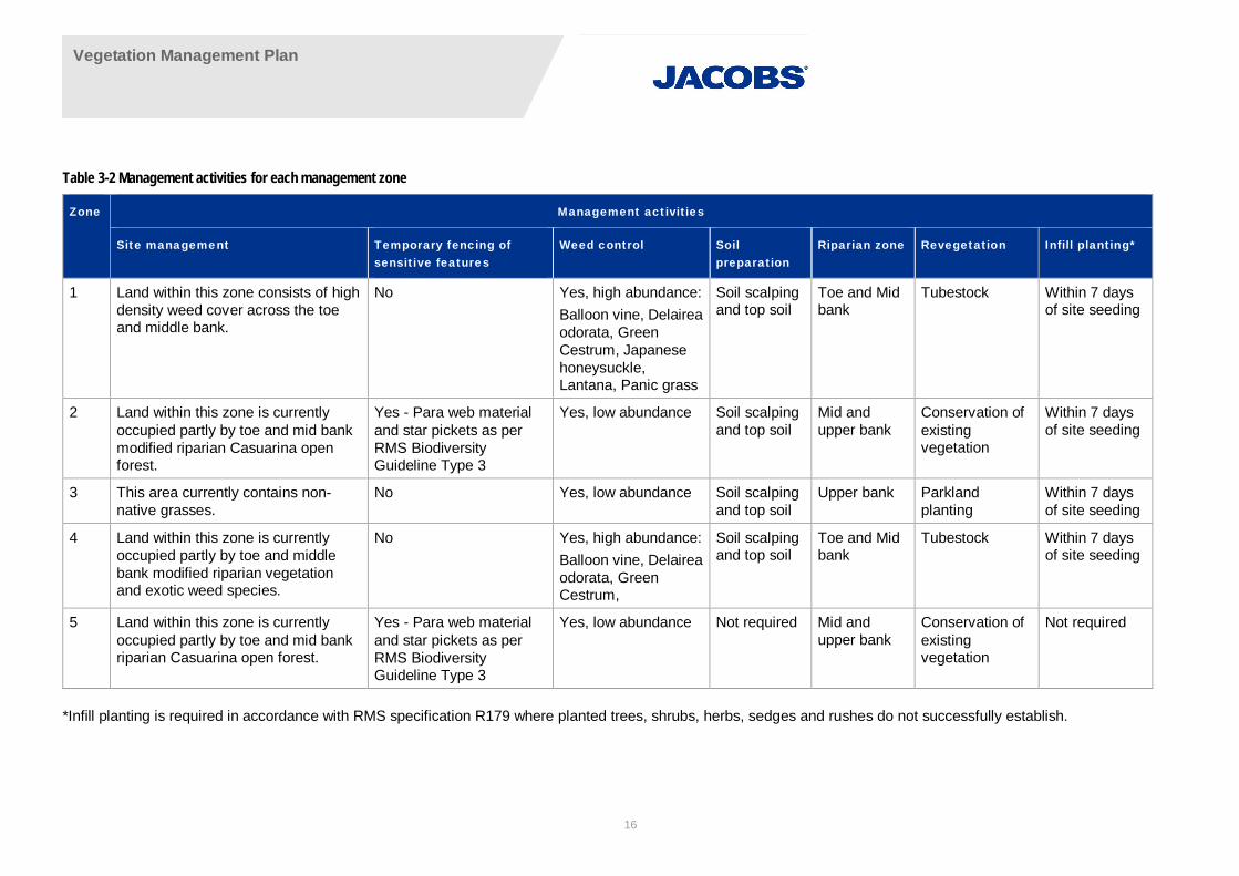
In line with the current bridge design, five (5) management zones have been delineated within the study area(Figure 3-3). Each of these management zones will require management activities that are sensitive to thedesired riparian zone, bridge infrastructure and the existing condition of the area. These zones are describedbelow and details of relevant management activities required or each zone are listed in Table 3-2.
Vegetation Management Plan
16
Table 3-2 Management activities for each management zone
Zone Management activities
Site management Temporary fencing ofsensitive features
Weed control Soilpreparation
Riparian zone Revegetation Infill planting*
1 Land within this zone consists of highdensity weed cover across the toeand middle bank.
No Yes, high abundance:Balloon vine, Delaireaodorata, GreenCestrum, Japanesehoneysuckle,Lantana, Panic grass
Soil scalpingand top soil
Toe and Midbank
Tubestock Within 7 daysof site seeding
2 Land within this zone is currentlyoccupied partly by toe and mid bankmodified riparian Casuarina openforest.
Yes - Para web materialand star pickets as perRMS BiodiversityGuideline Type 3
Yes, low abundance Soil scalpingand top soil
Mid andupper bank
Conservation ofexistingvegetation
Within 7 daysof site seeding
3 This area currently contains non-native grasses.
No Yes, low abundance Soil scalpingand top soil
Upper bank Parklandplanting
Within 7 daysof site seeding
4 Land within this zone is currentlyoccupied partly by toe and middlebank modified riparian vegetationand exotic weed species.
No Yes, high abundance:Balloon vine, Delaireaodorata, GreenCestrum,
Soil scalpingand top soil
Toe and Midbank
Tubestock Within 7 daysof site seeding
5 Land within this zone is currentlyoccupied partly by toe and mid bankriparian Casuarina open forest.
Yes - Para web materialand star pickets as perRMS BiodiversityGuideline Type 3
Yes, low abundance Not required Mid andupper bank
Conservation ofexistingvegetation
Not required
*Infill planting is required in accordance with RMS specification R179 where planted trees, shrubs, herbs, sedges and rushes do not successfully establish.

Vegetation Management Plan
17
Zone 1 - This zone is located in the north east of the project site, on the eastern side of the existing WindsorBridge and adjacent to the river channel. Land within this zone consists of high density weed cover across thetoe and middle bank. Due to the presence of exotic vegetation is recommended that the soil surface is preparedby scalping the existing topsoil to remove the weed seedbank prior to revegetation.
This zone is earmarked for scour protection at the toe and middle bank and two distinctive pockets of riparianrevegetation planting within the middle bank area as detailed below. A constructed bike pathway will delineatethis riparian revegetation area with planted parkland and native species representative of the plant communitytype River Oak open forest (PCT ID 1105) as detailed in Appendix A.
· Riparian Revegetation Area 1A - This area will be planted with riparian species as listed in AppendixA. Species planted in this zone should include those of the middle and upper bank types.
· Riparian Revegetation Area 1B - This area will be planted with riparian species as listed in AppendixA. Species planted in this zone should include those of the middle and upper bank types.
Zone 2 - This zone is located in the north west of the project site, on the western side of the existing WindsorBridge adjacent to the river channel. Land within this zone is currently occupied partly by toe and mid bankmodified riparian Casuarina open forest. Vegetation within this zone should be retained as much as possibleand weeds managed throughout the life of this VMP (i.e. a minimum of two years after the completion of worksor until such time as a minimum 80 per cent survival rate of each species planted and a maximum 5 percentweed cover for the treated riparian corridor controlled activity is achieved).
Zone 3 - This zone is located on the north east of the project site, on the eastern side of the existing WindsorBridge in the upper bank area. This area currently contains non-native grasses. Due to the presence of exoticweeds within this area it is recommended that the soil surface is prepared by scalping the existing topsoil toremove the weed seedbank prior to revegetation.
This area will be planted with a mix of parkland and native species as represented in the Windsor BridgeLandscape Design (Volume 12, Accepted for Construction, 04/05/2018) .
Zone 4 - This zone is located on the south of the project site, on the eastern side of the existing Windsor Bridgeadjacent to the river channel. Land within this zone is currently occupied partly by toe and middle bank modifiedriparian vegetation and exotic weed species.
· Riparian Revegetation Area 4 - This area will be planted with riparian species as listed in AppendixA. Species planted in this zone should include those of the toe and middle bank types.
Zone 5 - This zone is located in the south west of the project site, on the western side of the existing WindsorBridge and adjacent to the river channel. Land within this zone is currently occupied partly by toe and mid bankriparian Casuarina open forest. Vegetation within this zone should be retained as much as possible and weedsmanaged for a two-year period which commences after final planting.
The recommended layout for the riparian revegetation works are in 3 areas (Reveg1A, Reveg1B and Reveg4 –refer to Figure 3-2 and Figure 3-3). These areas are designed based on the required area for revegetation ofeach vegetation community, current distribution of vegetation community types, underlying geology, and siteconstraints. Appendix B outlines planting schedules for each revegetation area.
Each of the five management zones will be monitored throughout the life of this VMP to ascertain the success ofmanagement activities. This will be undertaken by way photo-point monitoring. Details of this methodology andmonitoring locations are described in Section 11.1 and shown in Figure 3-3.

Vegetation Management Plan
18
3.3 Delineation of revegetation areas
Each revegetation area at the site will be precisely measured and pegged out with clearly marked wooden stakes prior to the commencement of any revegetation works to clearly establish their location and extent. Areas of vegetation to be retained should also be clearly demarcated prior to the commencement of any clearing works.
The recommended layout for the revegetation works are in three areas (R1A, R1B and R4 - refer to Figure 3-3). These areas are designed based on the required area for revegetation of each vegetation community, current distribution of vegetation community types, underlying geology, and site constraints. Appendix B outlines planting schedules for each revegetation area.
Any vegetation areas outside the project area but disturbed by the works will be regenerated into pre-works condition.
Vegetation Management Plan
19
Figure 3-2 Layout of the existing riparian zones
Vegetation Management Plan
20
Figure 3-3 Proposed revegetation management zones
Vegetation Management Plan
21
4. Site preparationAppropriate site preparation is essential for a successful revegetation program. The biggest threats to therevegetation at the site would be inadequate weed control prior to seeding and planting and during themaintenance phase. Weed control is one of the most important features of any revegetation program and isoften a major factor in the success or failure of a revegetation project. Weed control and other necessary sitepreparation measures are outlined below.
The site must also be clearly delineated to identify where revegetation works are to occur, and where vegetationis to be retained. It is important that vegetation to be retained is fenced off prior to the commencement of worksas per the RMS Biodiversity Guidelines: Protecting and managing biodiversity in RTA projects (RTA, 2011a),and that all personnel involved in the project area are inducted to understand the ecological sensitivity of theseareas.
Revegetation areas will be established and signposted once the majority of the infrastructure works have beencompleted. Further requirements regarding the protection of vegetation to be retained during construction will bedetailed in the project Construction Flora and Fauna Management Plan (CFFMP).
Additional RMS QA roadworks specifications should also be adhered to during site preparation, specificallyR178 Vegetation and R179 Landscape Planting.
4.1 Controlling access
The vegetation to be retained, including the management zones, will be fenced off prior to the commencementof works as per the RMS Biodiversity Guidelines: Protecting and managing biodiversity in RTA projects (RTA,2011a).
4.2 Weed control
Successful weed control is important to ensure successful establishment and rapid early growth andestablishment of plantings. Failure to achieve appropriate weed control prior to planting will result in competitionby weed species which will severely affect the survival and growth rate of plantings.
Weed free conditions should be provided adjacent to the plantings and this is best achieved before plantingbegins. The revegetation areas should be treated for weeds at least one year before planting begins todecrease the weed soil seedbank and provide conditions suitable for planting native species. A combination ofthe techniques outlined above in Section 4-1 should be utilised during weed control activities. Managementmeasures for weed control are listed in more detail in the project EIS and must follow Guide 6: WeedManagement of the RMS Biodiversity Guidelines: Protecting and managing biodiversity in RTA projects (RTA,2011a). All weed material must be removed from site onto trucks immediately without stockpiling and disposedof at a licensed waste facility.
4.3 Stabilisation and weed suppression
Currently, the banks of the Hawkesbury River within the site have evidence of erosion, and the presence ofmodified riparian vegetation along the toe of the river provides some level of protection. The finished designincludes the addition of scour protection, consisting of large rock, on both the northern and southern bank.However, where construction is occurring next to the river banks, the contractor will be required to ensureadequate soil stabilisation controls are implemented to ensure the risk of bank erosion is avoided. Whererequired, appropriate erosion control and weed suppression measures will be implemented (for example,installation of thick jute mesh). Removal of the weedy groundcover will result in the rapid recolonisation of nativegroundcovers to aid in bank stabilisation. Where invasive bank stabilisation works are required along the creek,this will occur after primary weed control.
Where soft soil stabilisation methods are required to be implemented along the river banks to supportinfrastructure construction the following soil stabilisation guidelines will be followed:
Vegetation Management Plan
22
· In areas where there is a risk of erosion soil stabilisers are to be used such as geotextile material or thickjute mesh
· Temporary soil stabilisation using vegetation will avoid the introduction of exotic plants unless there is nosuitable native alternative. Where exotic species are used these will be sterile, non-invasive and easilyeradicated when permanent native vegetation is established (Office of Water, 2010).
4.4 In-stream Debris and Snags
The Hawkesbury River along the site contains limited large woody debris (LWD) but does contain habitatstructure in the form of debris dams and smaller woody debris, and these will be retained wherever possible.Snag removal will be minimised where possible (RTA, 2011a).. Management of snags or debris within thedevelopment footprint will follow the DPI Policy and guidelines for fish habitat conservation and management,(NSW DPI 2013).
4.5 Soil preparation
To provide optimal conditions for seed germination and seedling establishment, the soils at the site will requirepreparation. The requirements for optimal seed germination and seedling establishment are soft, uncompactedsoils and soil that is bare and free of weeds. As the areas to be revegetated are highly disturbed and dominatedby exotic species, soil preparation would be best achieved through a combination of scalping of topsoil andripping and ploughing.
Any new topsoil intending on being imported onto the site should have samples sent off to a NationalAssociation of Testing Authorities (NATA) approved soil laboratory to ensure it contains no weed seeds orpropagules (RTA 2011a).
4.5.1 Soil scalping
In areas dominated by exotic grass species it may be necessary to remove the topsoil layer in order to achievethe bare soil required for successful revegetation and to remove the weed soil seed bank to reduce competitionand make planting area maintenance easier (Schirmer & Field 2000).
There is no effective method of treating soil on-site that is highly contaminated with weed seeds or propagules.The top 2 to 10 cm of grass and topsoil should be removed with a machine that has a large blade (e.g. agrader), removed from site, and disposed of at an appropriate waste disposal facility.
4.5.2 Ripping and scarification
While not recommended for use in areas displaying the potential for natural regeneration, ripping is suitable foruse at the site in the revegetation areas as they have been subject to disturbance in the past which hascompacted the soil. Ripping will assist with the absorption and availability of soil moisture, soil aeration, and willcreate an environment where plant roots have easier access to resources.
Ripping and scarification can impact potential heritage items, and therefore, as per the MCoA, a ConstructionHeritage Management Sub-plan will be required prior to any construction. Details of management, strategiesand procedures for dealing with previously unidentified objects will be specified in this assessment and shouldbe read in conjunction with this plan.
Soil should be ripped to a depth of 20 to 50 cm with a multi tined ripper towed by a bulldozer or tractor thenscarified by a plough to a depth of 20 cm so that no large sods remain (Schirmer & Field 2000). Where theground is sloping, the rip lines should follow the bank contour to prevent erosion. Location details of whereripping and scarification is required prior to planting activities is included in the projects Urban Design andLandscape detail drawings (NB98005-ESD-DG-0101-0405).
Ripping and scarification of the soil is likely to stimulate weed growth and this should be monitored and treatedas part of the maintenance program.
Vegetation Management Plan
23
In areas where construction works have caused compacted soil, the soil should be decompacted when workshave been completed.
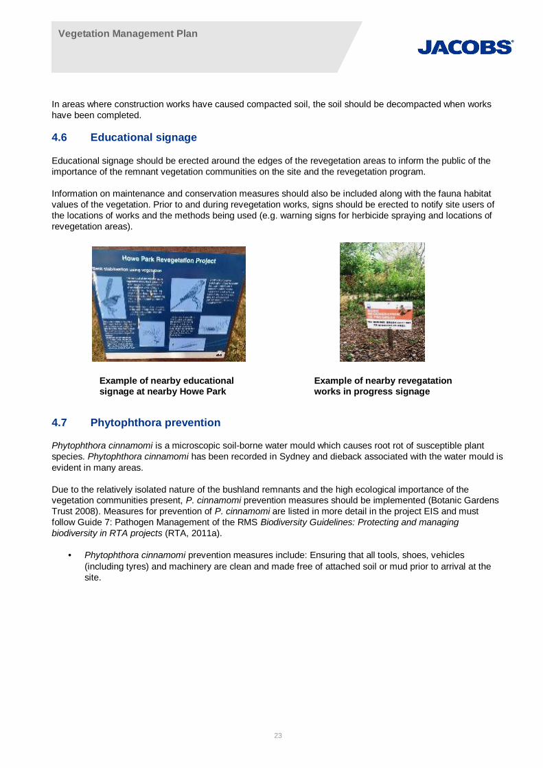
4.6 Educational signage
Educational signage should be erected around the edges of the revegetation areas to inform the public of theimportance of the remnant vegetation communities on the site and the revegetation program.
Information on maintenance and conservation measures should also be included along with the fauna habitatvalues of the vegetation. Prior to and during revegetation works, signs should be erected to notify site users ofthe locations of works and the methods being used (e.g. warning signs for herbicide spraying and locations ofrevegetation areas).
4.7 Phytophthora prevention
Phytophthora cinnamomi is a microscopic soil-borne water mould which causes root rot of susceptible plantspecies. Phytophthora cinnamomi has been recorded in Sydney and dieback associated with the water mould isevident in many areas.
Due to the relatively isolated nature of the bushland remnants and the high ecological importance of thevegetation communities present, P. cinnamomi prevention measures should be implemented (Botanic GardensTrust 2008). Measures for prevention of P. cinnamomi are listed in more detail in the project EIS and mustfollow Guide 7: Pathogen Management of the RMS Biodiversity Guidelines: Protecting and managingbiodiversity in RTA projects (RTA, 2011a).
· Phytophthora cinnamomi prevention measures include: Ensuring that all tools, shoes, vehicles(including tyres) and machinery are clean and made free of attached soil or mud prior to arrival at thesite.
Example of nearby educationalsignage at nearby Howe Park
Example of nearby revegatationworks in progress signage
Vegetation Management Plan
24
5. Revegetation methodsThe best approach to revegetation is to use a combination of available methods. This often means utilisingmethods such as assisted natural regeneration (bushland regeneration) and active revegetation such as directseeding and the planting of tubestock. This technique allows for the most appropriate technique to be used ineach area within the site, and compensates for seasonal fluctuations to ensure that plants will survive past theinitial establishment period.
5.1 Weed removal
Weed control should be undertaken using a staged approach incorporating three levels of treatment: Primaryweed clearance; followed by Secondary treatment or follow-up; and finally Maintenance weeding (National Trustof Australia 1999).
Primary weed clearance refers to the initial treatment of a weed infestation. Secondary treatment or follow-upworks refer to the intensive weeding of areas that have already received primary weeding, removing the largestflush of second generation weeds that have germinated from soil stored seed and those that were notsuccessfully killed during primary weeding. Native regeneration is also encouraged during this stage. Once anarea has been restored and preventive measures to stop weed recruitment on site have been implemented, themaintenance weeding phase can begin. It is inevitable that weeds will re-establish on site due to dispersal andthe soil seed bank will also be a continual source of new weed infestations so regular maintenance works will berequired.
The techniques to be used to control weeds should include a combination of the following techniques asnecessary:
· Hand removal and cultivation
· Mulching
· Cut and paint with herbicide
· Scrape and paint with herbicide
· Stem injection, frilling or chipping with herbicide
· Foliar spot spraying with herbicide.
5.1.1 Hand removal and cultivation
Hand removal or cultivation with small tools aims to remove and destroy the existing plants and prevent theplants from setting seed. Therefore, the timing of hand removal and cultivation is important as well as thetechnique. Hand removal and cultivation is best carried out before the plant seeds, or if the plant is seeding, thefruits must be bagged and removed from site. Different cultivation methods may kill the existing plant dependingon whether or not the plant can sucker and reproduce vegetatively, in which case the roots, tubers, and cormsmust be controlled as well as the stems (Ensbey & Johnson 2007). Hand removal and cultivation techniquesmay:
· Remove plants and expose roots to dry them out
· Bury shoots to stop them growing
· Separate shoots from roots
· Bag seed heads and flowers and then remove the whole plant (roots, crown and stems).
Correct disposal of vegetative matter after cultivation is imperative for species that reproduce vegetatively orthose that produce many seeds. Appropriate disposal methods include burning piles in accordance with RuralFires Service (RFS) guidelines for pile burns or storing on site wrapped in plastic until the plant decomposes(composting). For non-vegetative reproducing species or those without seeds present, bagging and disposal indomestic green waste bins or at a waste disposal centre equipped to handle green waste is sufficient.

Vegetation Management Plan
25
5.1.2 Mulching
Mulching uses barriers to exclude light and prevent the establishment of weeds. A bobcat or other vehicle canlay barriers (i.e. geotextile cloth) according to RMS specification R63, but due to the material’s expense this isonly viable for smaller areas. Traditional mulching with wood chips or using a Hydroseeder machine is morecost effective (Ensbey & Johnson 2007).
5.1.3 Cut and paint with herbicide
Cut and paint is a method of weed control for woody weeds where by the stem or trunk of the weed is cuthorizontally near the ground then herbicide applied to the living plant tissue across the cut surface. The besttechnique for the cut and paint method is as follows:
· Cut the stem as near towards the ground as possible, leaving a horizontal surface so the herbicide doesnot run off.
· Paint the living tissue of the open wound with herbicide evenly (within 10 seconds of cutting the stem forwater based herbicides and 1 minute for diesel based herbicides).
The cut and paint method is advantageous as it removes the weed straight away. This technique is best usedon woody shrubs and trees. Some species will sucker after being treated with this technique (e.g. Sennapendula var. glabrata, Ochna serrulata, and Cinnamomum camphora); therefore, cut and paint is notappropriate for these species unless follow up treatment will be employed (Ensbey & Johnson 2007).
5.1.4 Scrape and paint with herbicide
The scrape and paint method is similar to the cut and paint method but is used for smaller shrubs that willsucker if the cut and paint method is applied (e.g. S. pendula var. glabrata, O. serrulata, and C. camphora) andfor vines with aerial tubers (e.g. Anredera cordifolia). The scrape and paint technique should be used on plantswith stems or trunks less than 5 centimetres (cm) in diameter (Ensbey & Johnson 2007). The correct techniquefor the scrape and paint technique is as follows:
· Scrape a vertical section of the bark off both sides of the stem down to the cambium layer (with a sharpknife or chisel) approximately 5 cm in length to where the stem meets the ground, without ringbarking theplant.
· Apply herbicide on the open wound (as per the cut and paint method).
5.1.5 Stem injection, frilling or chipping with herbicide
If required on site, stem injection, frilling or chipping is a method that can be employed successfully in a numberof situations to treat large mature woody weeds with a trunk diameter of more than 5 cm. At inaccessible siteswhere rubbish and debris prevent removal, where the tree should be left in situ to provide fauna habitat, orwhere removal would increase soil erosion, stem injection, frilling or chipping are appropriate methods of weedcontrol (National Trust of Australia 1999). The following outlines the appropriate method for stem injection,chipping and frilling:
· Using a drill, chisel, saw, or axe, make holes or a deep cut at a downward angle (45 degrees) into thesapwood at regular intervals of 5 cm apart around the tree in a circle
· Do not ringbark the plant
· For multi stemmed plants drill or chip below the lowest stem or treat each stem individually
· Apply herbicide into the hole or cuts at the recommended rate by the manufacturer
· Reapply herbicide when the first application is absorbed into the plant.
5.1.6 Foliar spot spraying with herbicide
Foliar spraying of herbicide is an option for the control of shrubs, herbs, grasses, and vines. Spraying can beconducted with a small volume hand operated backpack sprayer or a large volume motorised spray unit
Vegetation Management Plan
26
mounted on a vehicle. The type of environment, presence of native species, site access, and desired controloutcome will determine the techniques used in herbicide spraying (Ensbey & Johnson 2007). When applying thefoliar spray technique the following must be adhered to:
· Only spray designated areas to avoid off target damage
· Ensure that when spraying the whole plant is treated (100% foliar cover)
· Only spray healthy and actively growing plants to ensure effective uptake of herbicide
· Do not spray in windy conditions, excessively hot conditions, if plants are heavy with dew, or if rain isexpected within four hours.
5.1.7 Revegetation
Revegetation is preferred in areas that are considered to have a low ability to recover naturally, even with theassistance of weed control. This may be due to a long history of disturbance in these areas resulting in loss ofnative species, soil compaction, and an altered soil seed bank composition. Active revegetation areas form thebulk of revegetation required for this vegetation management plan.
Active revegetation essentially involves planting by mechanical or hand methods and will usually involve theinstallation and maintenance of an irrigation system, and a weed management program. Active revegetation ismost appropriate when:
· The natural regeneration potential of a site has been wholly or severely depleted
· Key missing species cannot be naturally recruited to an area
· Soil profiles have been altered resulting in loss of the natural seed bank.
Revegetation will aim to protect existing remnant bushland as per the MCoA and plant species in similarcomposition to that which occurs in vegetation adjacent to the revegetation sites (e.g. River Oak open forest).Given the relatively small area of riparian planting areas and to maximise the chance of successful revegetationthe preferred method of planting is via tubestock planting detailed below.
5.1.8 Tubestock planting
Planting of tubestock (seedlings in small plastic forestry tubes) provides guaranteed plant material to arevegetation site and is the most common method used to reintroduce vegetation to an area. Althoughtubestock planting is more expensive and labour intensive than direct seeding, the results are more reliable andan immediate impact is made on the environment. The positioning and placement of plants is also able to becontrolled. Other advantages of using tubestock are that less transplant shock is suffered and they rapidlyestablish healthy root systems (Florabank, 2008). An immediate visual impact is also evident which signifies thatrevegetation is taking place.
Vegetation Management Plan
27
6. Plant species selectionThis section outlines the plant species selection and planting density. Plant species are chosen based on thosethat would have occurred naturally on site. The species mix is chosen to emulate the revegetated community.Density will be high enough to quickly establish vegetative cover and root mass to stabilise the riparian zone. Asterile exotic cover crop (like sterile rye grass or Japanese millet) may be initially used in some cases tostabilise soil.
The general principle behind the selection of plant species to be used in revegetation at the site is to establishplants in areas that:
· Suit the site characteristics
· Are native to the area and vegetation community that is being enhanced
· Belong together naturally
· Have been grown from local seed.
Selection criteria for plant species to be used in the revegetation are provided below.
6.1 Selection criteria
6.1.1 Provenance
As per the MCoA C36, seeds used for rehabilitation in the riparian corridor are to be acquired from local nativeprovenance where possible. Local native provenance refers to seeds found in local or adjacent areas in thesame type of vegetation community so as to simulate the original species that would be found at the site forrevegetation. These species are adapted to the environmental conditions, pollinators, predators, symbionts anddependent on wildlife present on site (Florabank 2008). This will also avoid introducing exotic species and willretain vegetation community integrity (refer Appendix A for list of suitable species for use in revegetation).
Where possible plants used in revegetation will be sourced from seed collected on site or from CumberlandRiver Flat Forest or Swamp Oak open forest (PCT ID 1105) in the surrounding area to ensure local provenance,avoiding dilution of the plant gene pool on site. Using plants of local provenance in revegetation will ensure thatthe genetics, and morphological and physical traits of the species selected for revegetation will be similar tothose that currently exist in the vegetation communities on site (Florabank 2008).
Florabank (2008) recommends that provenance be considered in the following manner when collecting seed:
· Ensure correct plant identification during collection to make sure you are dealing with the samespecies/subsp/variety or cultivar
· Collecting from 20–100 plants that are at least 3 plant-heights apart
· Only collect from large populations or pool multiple collections from smaller populations
· Store seed under appropriate conditions from collection through to use
· Match the site conditions of collection, including soil, altitude, aspect, slope, and latitude, to therevegetation area.
6.1.2 Species diversity
The revegetation program will seek to maximise species diversity. By introducing all structural vegetation layersat once (e.g. trees, shrubs, grasses, sedges, groundcovers, and climbers) multiple planting events are avoidedand disturbance to the revegetation areas is minimised. Using a balanced mix of species from the majority ofplant families that are found in naturally occurring examples of the vegetation community that is being plantedwill avoid the overuse of readily obtainable species (e.g. Lomandra longifolia). As such, a natural vegetationcommunity will be created that contains higher biodiversity value (Department of Environment and Conservation2005).
Vegetation Management Plan
28
6.1.3 Succession and nitrogen fixation
It is important to include a mix of coloniser species, such as Acacia spp. and Dodonaea spp. that will establishand grow quickly in the revegetation areas. These species help to create the optimal environment for speciesthat are slower to colonise areas to establish. Acacia spp. and Casuarina spp. form symbiotic relationships withnitrogen fixing bacteria and fungi that make nitrogen available in the soil for plants. As Acacia spp. andCasuarina spp. are naturally occurring in the vegetation communities that are to be revegetated, they will beincluded in the species mix.
The presence of these early successional and nitrogen fixing species will increase soil carbon, reduce surfacetemperature variation, reduce erosion, and create surface conditions conducive to the establishment of otherlonger lived native plant species such as Eucalyptus spp. and Angophora spp. (Department of Environment andConservation 2005).
6.2 Recommended species mix and planting density
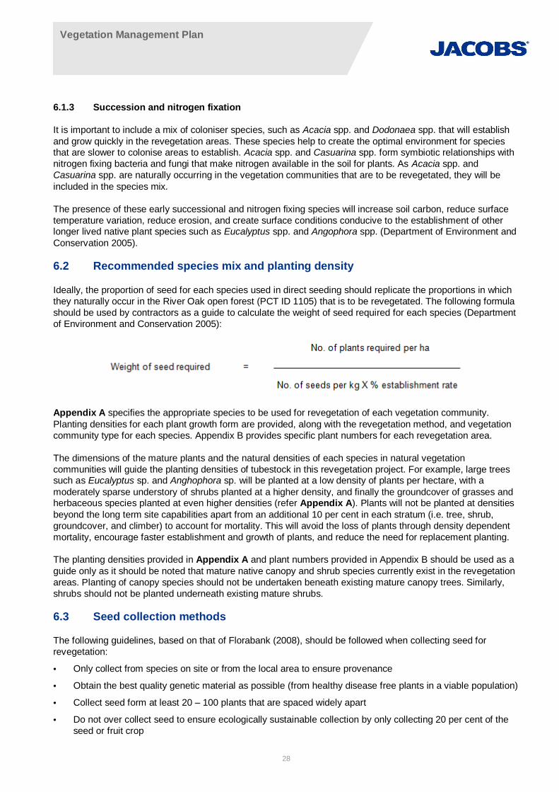
Ideally, the proportion of seed for each species used in direct seeding should replicate the proportions in whichthey naturally occur in the River Oak open forest (PCT ID 1105) that is to be revegetated. The following formulashould be used by contractors as a guide to calculate the weight of seed required for each species (Departmentof Environment and Conservation 2005):
Appendix A specifies the appropriate species to be used for revegetation of each vegetation community.Planting densities for each plant growth form are provided, along with the revegetation method, and vegetationcommunity type for each species. Appendix B provides specific plant numbers for each revegetation area.
The dimensions of the mature plants and the natural densities of each species in natural vegetationcommunities will guide the planting densities of tubestock in this revegetation project. For example, large treessuch as Eucalyptus sp. and Anghophora sp. will be planted at a low density of plants per hectare, with amoderately sparse understory of shrubs planted at a higher density, and finally the groundcover of grasses andherbaceous species planted at even higher densities (refer Appendix A). Plants will not be planted at densitiesbeyond the long term site capabilities apart from an additional 10 per cent in each stratum (i.e. tree, shrub,groundcover, and climber) to account for mortality. This will avoid the loss of plants through density dependentmortality, encourage faster establishment and growth of plants, and reduce the need for replacement planting.
The planting densities provided in Appendix A and plant numbers provided in Appendix B should be used as aguide only as it should be noted that mature native canopy and shrub species currently exist in the revegetationareas. Planting of canopy species should not be undertaken beneath existing mature canopy trees. Similarly,shrubs should not be planted underneath existing mature shrubs.
6.3 Seed collection methods
The following guidelines, based on that of Florabank (2008), should be followed when collecting seed forrevegetation:
· Only collect from species on site or from the local area to ensure provenance
· Obtain the best quality genetic material as possible (from healthy disease free plants in a viable population)
· Collect seed form at least 20 – 100 plants that are spaced widely apart
· Do not over collect seed to ensure ecologically sustainable collection by only collecting 20 per cent of theseed or fruit crop

Vegetation Management Plan
29
· Do not damage the donor plant or the surrounding environment during collection.
6.3.1 Seed collection permits and licences
In order to undertake seed collection in endangered ecological communities near to the site if required (i.e. fromRiver Flat Eucalypt Forest), a state licence under the TSC Act would be required as follows:
· Section 91 Licence to harm or pick a threatened species, population or ecological community or damagehabitat listed under the TSC Act (e.g. River-flat Eucalypt Forest in the NSW North Coast, Sydney Basinand South East Corner Bioregions (endangered)).

Vegetation Management Plan
30
7. Plant propagationA number of species that are to be used in the revegetation are best established by propagation in a nursery. Alltubestock and species for which seed is hard to obtain will be propagated in a nursery to ensure that use of thelimited seed is optimised.
Propagation can be achieved from seed or from cuttings. Most plants to be used in the revegetation can besuccessfully grown from seed (e.g. Eucalyptus spp. and Acacia spp.) however; some species are moresuccessfully grown from cuttings. The nursery contracted for propagation and plant supply will be able toprovide advice on the most appropriate techniques for propagation of each species.
Vegetation Management Plan
31
8. Plant installation guidelines8.1 Direct seeding
Instead of spreading seed by hand, a Hydroseeder or similar machine can be used to quickly and economicallyseed large areas as the seed, fertilizer, mulch, tackifier and water are all applied at once. The seed, water andmulch are mixed in the tank of the Hydroseeder to form a slurry, which is then sprayed over the site through ahigh pressure water cannon.
8.2 Tubestock planting
Tubestock, grown in small square plastic nursery tubes, is the preferred method of revegetation for tree andshrub species. Planting of tubestock will be carried out using hand tree planting tools and should be conductedin the following method:
· Rake away an area of mulch (min 300mm x 300mm) to expose the soil
· Dig a hole at least twice the size of the tube / pot (min 300 x 300 x 200mm deep)
· Disturb the surrounding substrate up to 100mm to avoid leaving 'clean' sides and base of the hole,particularly when an auger has been used to dig the hole
· Add a slow release fertiliser and soil-wetting agent to the base of the well and cover with a small amount ofexisting soil, or mix in with the soil to be placed back around the plant. Avoid any contact of the fertiliserand soil-wetting agent with the plant roots
· Plant the seedling slightly below the soil level and back-fill the hole with existing soil, covering the top of thepotting mix. Create a small well to the catch water
· Replace mulch around the plant. Ensure no mulch touches the base of the trunk, maintaining a space of50-100mm between mulch and trunk
· Erect a 'Growtube' around each plant. Remove Growtubes when plants are at 1.5 times the height of theGrowtube
· Water each plant thoroughly within 1 hour of planting.
8.3 Plant spacing
Appropriate spacing between plants will assist in higher survival rates and lower maintenance costs. Highdensity planting with fast growing species not only creates an early canopy cover, providing shade cover forweed suppression and habitat for native fauna, but also begins the process of protecting and stabilising thebanks. Plant spacing within the riparian corridor should be as follows:
· Lower Bank (for areas where scour protection is not being installed) – Lomandra and sedges to be plantedin clumps or rows along the Lower Bank or at 1m centres. Plant trees and shrubs at a wider spacing of 2m– 3m in stable conditions.
· Mid and Upper Bank – Tree, shrub, native grasses and ground cover species should be planted at 1.5m –2m centres. Extend Lomandra plantings from the Lower Bank into the Mid Bank zone. For good structuraldiversity, plant an even ratio of tree, shrub and ground cover species.
8.4 Timing
Choosing the best time to undertake riparian revegetation plantings is difficult due to the potential impacts offrost, drought, flood and erosion on seedlings and young plants. Spring is the preferred time for planting to allowfor strong establishment of the root structure and good plant growth, before floods or frosts.
Pre-winter planting is not advisable, however, this is not always possible to avoid. Choose hardy species withhigh frost tolerance, and wherever possible, extend plantings over to spring to ensure better revegetationsuccess of the site. On some sites where there is a risk of soil loss, provide protection to the banks with covers

Vegetation Management Plan
32
such as jute mat, Geofabric or Coconut Coir. Refer to manufactures specifications and understand siteconditions before using these products.
8.5 Plant protection
To aid in identification of plantings, a large wooden stake should be placed next to all plants to preventincidental damage to the plantings during maintenance activities. Tree guards should be installed over thenewly planted seedlings to provide protection from grazing animals during the plant establishment period.
8.6 Weed control and mulching
A weed suppression mat is to be installed around the base of each seedling to reduce competition from weedsin the immediate area of each planting. Mulching also provides protection to bare soil, retention of soil moistureand suppression of weed re-growth. Due to the difference in size and complexity of the management areas, it isrecommended that both ‘mulching’ and ‘hydromulching’ techniques are adopted:
· Mulching – Organic mulch such as hoop pine fines or similar (to meet AS4454-2003). Ensure that mulch isfree of weed seed or foreign objects. Spread to a depth of 100mm–150mm and allow to settle for four (4)weeks before planting seedlings. Spot spraying of any emerging weeds maybe needed at this stage. Theuse of mulch is only recommended on the Mid and Upper Banks, with a slope less than 1:1.5
· Hydromulching – An alternative technique that can be used for covering steep banks with a sprayed-onmixture of fertilisers, seeds, water and mulch. It is often used where there is a large area of bare earth orthe site is too steep for safe access with machinery or people. This technique is relatively expensive, but isuseful in instances where planting of seedlings is not practical. The seed mix is to consist of native trees,shrubs and grasses, in accordance with supplier’s standard specifications and subject to Hawkesbury CityCouncil approvals.
8.7 Watering
Watering would be required in accordance with RMS specification R179, which includes the following wateringschedule:
(i) 20 litres of water per plant at weekly intervals for the first 12 weeks;
(ii) 10 litres of water per plant at 14 day intervals thereafter.
Watering may be undertaken by regular visits using a truck or by installation of an irrigation system. A dripirrigation system should be installed with the main system laterals in place before planting begins to allow forthe installation of emitters and required tubing as the plants are installed
Vegetation Management Plan
33
9. Planting area maintenanceMaintenance requirements should extend for a minimum of 2 years or until plants become self-sustaining (nowatering required), weed growth is low (maximum 5 per cent weed cover) and a minimum 80 per cent survivalrate of each species planted and for the treated riparian corridor controlled activity is achieved (CoA C37; NSWOffice of Water 2012a).
9.1 Short-term maintenance
This period is from the date that construction commences until the completion of works.
9.1.1 Weed control
Weed control is the most important feature of any maintenance program and is often a major factor in thesuccess or failure of a revegetation project. A weed free area of at least 1 metre in diameter should bemaintained around the planting at all times to reduce competition for resources and encourage establishment(Florabank 2008). Spot spraying with a contact herbicide such as Glyphosate or non-chemical methods such ashand removal and mulching can be used.
9.1.2 Irrigation
Watering of seedlings will be necessary in the initial weeks after planting and the level of watering required willbe determined by rainfall and temperature. More watering will be required in hot dry conditions. Irrigation will berequired for the first year after planting and should be used as a supplement to seasonal precipitation toestablish plants. After the first year, depending on plant condition, the irrigation system should be removed toallow plants to adapt to the site. Maintenance of plant stakes and bags will also be necessary.
9.2 Long-term maintenance
This period is a minimum of two years after the completion of works or until such time as a minimum 80 per centsurvival rate of each species planted and a maximum 5 per cent weed cover.
9.2.1 Weed control
The weed control program should be the focus of maintenance activities over the long-term to remove weedsfrom site and allow the plantings to establish successfully. Weeding should be conducted around the plantingsfor at least five years until a canopy can be formed that will potentially shade out weed species (Florabank2008). The aim of revegetation will be to create a self-sustaining area of bushland and this can only be achievedby a long-term weed control program.
Revegetation maintenance
· Removal of Growtube bags and bamboo stakes at specified plant height
· Removal, and where necessary replacement, of any bank protection material (e.g. Jute Mat) that has beendisplaced through flooding, poor installation or vandalism.
9.2.2 Fertilisers
Native plants are generally adapted to survive in low nutrient locations. Application of a broad fertiliser to thesite is likely to encourage weed growth. Fertiliser tablets are effective and can be used at the bottom of eachplanting hole to encourage growth where species require.
9.2.3 Pests and diseases
New plants are extremely susceptible to pests and diseases and these must be identified and managed quicklyin order to avoid significant plant losses. New plantings (whether initial or replacement plantings) will be
Vegetation Management Plan
34
monitored for pests and diseases every week for the first month and then quarterly. Plants decimated by pest ordisease will be removed immediately and disposed of offsite. The type of species affected the type of pest ordisease affecting the plant and the location for replanting will be recorded. Replacement planting in this instancewill occur as part of a bulk plant replacement program every six months, unless local provenance replacementplants are readily available to be planted in a suitable season – preferably autumn.
Plant pests and diseases frequently strike as plagues or under certain climatic conditions. Opportunities to co-ordinate site pest and disease control programs will be investigated through contact with Hawkesbury CityCouncil and NSW Agriculture.
9.2.4 Plant protection
Plant markings and plant protection must be maintained during the initial stages of plant establishment. Asrabbits have been previously identified on the site during preliminary environmental investigations (LEC 2002),grazing prevention is important for the successful establishment of plants in the revegetation areas. Tree guardsare the preferred method to avoid seedling death due to grazing and can be either the cardboard milk carton orplastic bag type (Florabank 2008). After the first year, the revegetation site should be walked and the plantsassessed to determine which are sufficiently established and no longer need protection.
9.2.5 Pruning
Pruning of plants may be required to ensure views to important landmarks in particular the Hawkesbury River,Thompson Square and the historic buildings around Thompson Square are maintained. Pruning requirementswill be identified in the maintenance inspections.
9.2.6 Replacement planting
Replacement planting may be required where seedlings do not successfully establish in the revegetation area.This will most likely occur within the first year of planting. Additional planting should be undertaken to replacedead plants and fill gaps (Florabank 2008). A survival rate of at least 80% should be obtained in therevegetation area.
9.2.7 Thinning
Problems may arise with overcrowding of plantings and where natural regeneration occurs amongst the plantedspecies. Thinning of plants may be required to enhance the survival of plantings or natural regeneration;however, this is unlikely to be necessary due to the recommended planting densities and the process of naturaldensity dependent mortality.
9.2.8 Deep Watering
Deep watering will occur quarterly, dependent on local climatic conditions, and will continue until all plants areestablished. During extended dry periods plant health and soil moisture will be checked weekly. Watering will beundertaken early in the morning to avoid evaporation during the middle of the day.
9.2.9 Rubbish Removal
The riparian corridor will continue to receive rubbish in high flow events from upstream. Rubbish will becollected quarterly (or following a flooding event) and disposed of appropriately. If debris is considered to beproviding fauna habitat, then it will remain in-situ until alternative suitable habitat has been provided. This mayinclude dead timber/logs, rocks or vegetation.
9.2.10 Maintenance Inspections
Maintenance inspections are required to gain an overall assessment of how each of the management zones areresponding to the suite of rehabilitation works implemented across the site. The intention is to draw together allof the maintenance information recorded by the bush regeneration contractor over a period of three months and

Vegetation Management Plan
35
compare this to the objectives of the project. Maintenance inspections also involve site inspections and act as aquasi-audit to satisfy both the proponent and regulatory authorities that CoA and SOC requirements are beingmet. Maintenance inspections can be reduced to six monthly post-construction. This will not occur until the sitehas been operating for six months. Maintenance inspections will be undertaken for all management zones.
Quarterly maintenance inspections will comprise the following:
· Weeds - Assessment of average densities of each weed species within each management zone,observations and treatment recommendations
· Pests and disease – Number and types of species affected, type of pest or disease, percentage of speciesaffected, observations and treatment recommendations. This includes grazing by feral and native animalsand the success or otherwise of any programs to protect regenerating areas from such impact
· Planting – Estimate of initial planting success, trends in unsuccessful establishment of particular species,plant size and spread and evidence of natural regeneration
· Erosion – Inspection of rehabilitation and erosion control in riparian areas next to the bridge construction,photo monitoring points will be established at this site to track change over time
· Deep watering – Assessment of general soil moisture in each management zone and information onobserved watering requirements by species
· Mulch – Depth of mulch should be measured and maintained.
9.3 Revegetation timeline
Figure 9-1 provides a timeline summary of revegetation activities
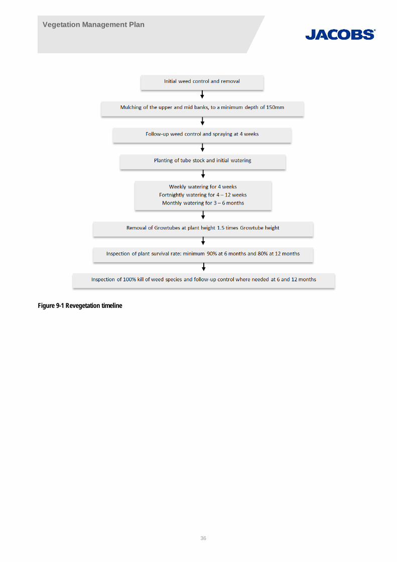
Vegetation Management Plan
36
Figure 9-1 Revegetation timeline
Vegetation Management Plan
37
10. Implementation schedule and indicative cost analysis10.1 Implementation schedule
The entire area is to be revegetated over a period of 3 years, subject to budget and staffing constraints. Thiswould include an initial year of weed control, site assessment and planning, soil preparation, plant speciesselection, seed collection, and propagation. Plant installation will begin in the second year. Planting areamaintenance would begin directly after the first plantings and continue for a two year period post construction.
A timeline for completion of each management action outlined in this plan is provided below in Table 10-1. Eachaction has been assigned a priority, a recommended time-frame for implementation and a checkbox forcompletion.
Table 10-1 Implementation schedule for each management action
Management action
Construction
PostConstruction* Priority Complete
Year 1 Year 2
· Revegetation areas delineated bypegging P High ¨
· Site preparation:
- Initial weed control P High ¨- Soil preparation P High ¨- Educational signage P Medium ¨- Phytophthora prevention P P P High ¨
· Plant species selection P High ¨· Plant propagation P High ¨· Plant installation P High ¨· Planting area maintenance P P High ¨· Monitoring P P High ¨· Reporting P P P High ¨
*Maintenance and monitoring must extend for a minimum of two years after the completion of works or until such time as aminimum 80 per cent survival rate of each species planted and a maximum 5 per cent weed cover.
10.2 Roles and responsibilities
There are a number of key roles in the VMP which, by the technical nature of the regenerative works, should beundertaken by contractors or consultants external to both the proponent (Roads and Maritime Services) and theconstruction contractor for the site. Key roles and responsibilities associated with the implementation of theVMP, including statutory reporting, are outlined in Table 10-2.
Roads and Maritime is responsible for the revegetation program and its implementation. It is envisaged that amaintenance contractor(s) will be engaged by Roads and Maritime to undertake and complete the revegetationworks.
Vegetation Management Plan
38
The chosen contractor(s) will be responsible for all facets of the maintenance program including the sitepreparation, plant species selection, plant propagation, plant installation, planting area maintenance, monitoring,and reporting.
Table 10-2 Roles and responsibilities
Role Responsibilities
Roads and MaritimeServices projectmanager
Co-ordination of VMP associated conditions with clearing and construction worksensure native vegetation to be retained will be protected, as practical / whereapplicable and enhanced through the life of the project.Completion of site management to ensure ongoing protection of regeneratedsites post-maintenance period.
Construction contractor Compliance with the requirements of the VMP.
Ecologist
Management and implementation of the VMP, including performance indicatormonitoring, provision of technical advice and statutory reporting to theconstruction contractor.Certification of completion of maintenance project by achievement ofperformance indicators.
Bush regeneration sub-contractor
On-ground works associated with the VMP, maintenance inspections andmeeting of performance criteria, including the management of pest speciescontractor, if required.Certification of supply and installation of local provenance native seed.
Consent authority
Certification of commencement of maintenance period.Inspection of restoration and revegetation works during maintenance period.Certification that restoration and revegetation works have met the assessmentcriteria at completion of the maintenance project.
10.3 Indicative cost analysis
The cost of works may be used as a bond by the NSW Department of Planning and Environment (DPE) toensure that the proponent actions the VMP. The proponent receives the bond back upon completion of themaintenance period if they have implemented the VMP as stated.
Revegetation costs may be very variable depending on the needs of the site, the intensity of planting, size of thearea planted, and the labour source (Schirmer & Field 2000). Based on current market rates, it is estimated thatthe two year riparian revegetation program would cost approximately $110,457 (refer Table 10-3). This costanalysis covers the revegetation program from initial site preparation to final monitoring. As such, it should beused as a guide when judging tenders for the engagement of a contractor to implement the revegetation plan.
Table 10-3 Indicative cost analysis for the revegetation project
Item Unit Quantity Cost
Site preparation $180/ha machine hire 36 hrs $4,320
Plant operator labour costs @ $100/hr 36 hrs $3,600
Mulching $220/tonne 20 $4,400
Application via blower operation 1 day $3,000
Jute matting / erosion controlblanket
1.22m x 68m @ $99.00 40 $4,000
Trees Approximately $350 for a 75L species 33 $11,550
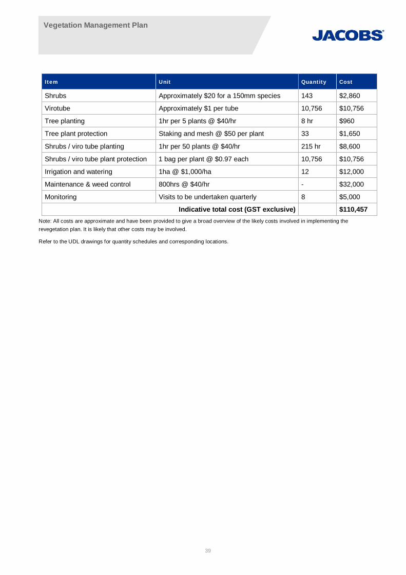
Vegetation Management Plan
39
Item Unit Quantity Cost
Shrubs Approximately $20 for a 150mm species 143 $2,860
Virotube Approximately $1 per tube 10,756 $10,756
Tree planting 1hr per 5 plants @ $40/hr 8 hr $960
Tree plant protection Staking and mesh @ $50 per plant 33 $1,650
Shrubs / viro tube planting 1hr per 50 plants @ $40/hr 215 hr $8,600
Shrubs / viro tube plant protection 1 bag per plant @ $0.97 each 10,756 $10,756
Irrigation and watering 1ha @ $1,000/ha 12 $12,000
Maintenance & weed control 800hrs @ $40/hr - $32,000
Monitoring Visits to be undertaken quarterly 8 $5,000
Indicative total cost (GST exclusive) $110,457Note: All costs are approximate and have been provided to give a broad overview of the likely costs involved in implementing therevegetation plan. It is likely that other costs may be involved.
Refer to the UDL drawings for quantity schedules and corresponding locations.

Vegetation Management Plan
40
11. Monitoring, reporting and success criteriaProcesses for monitoring and review including a method of performance evaluation need to be identified in thissection.
11.1 Monitoring procedure
The success of revegetation measures should be monitored as part of this revegetation plan to assess itseffectiveness and to determine the need for amendments or otherwise to the revegetation strategy. The datagathered can be compared to reference sites established in adjacent vegetation communities in good conditionto determine the success of revegetation. A monitoring option is to establish a set of monitoring quadratsthroughout the revegetation area that can be compared to reference sites. A monitoring program such as thiscan determine the effectiveness of revegetation measures in all areas proposed for revegetation.
The monitoring program is as follows:
· The monitoring quadrats should be 10 x 10 m in size set up in each revegetation area
· Assessment could include recording cover abundance ratings (Braun-Blanquet cover codes) and stemdensity for weeds and native species as well as an inventory of all species present in each quadrat. Inaddition, in consultation with RMS biodiversity specialists, an alternative method (Tongway & Hindley 2003)for Landscape Function Analysis (LVA) can be considered when there is disagreement over the results ofthe primary assessment criteria.
· Photographic monitoring should occur at a fixed location at each monitoring point to provide a visualindication of the success or otherwise of the revegetation works. Appendix C provides a basis for this formof monitoring.
· Quadrats may be pegged at each corner with a star picket and their location recorded using a GPS
· Quadrats should be monitored every three months during the first year of the revegetation program thenevery six months for the remaining life of the program.
· Reporting is required after each monitoring event in the form of a concise monitoring report including keyobservations and supporting photographic evidnece
Photo points are permanent or semi-permanent sites set up from where you can take a series of photographsover time which can be compared to show short- or long-term physical change at each location. The pictures forcomparison are taken at the same location, with the same direction (south), angle, focus points and preferablycamera settings. Photo monitoring points will be used within each management zone to demonstratecompliance with performance criteria or otherwise. Draft photo point locations have been established in eachmanagement zone and preliminary photos are supplied in Appendix C. Table 11-1 lists the coordinates andbearing of each proposed photo point monitoring locations and shown graphically on Figure 11. However, thefinal locations of the photo monitoring points will be determined once the limits of clearing associated with theproposal are clearly demarcated by fence lines. Establishment and use of photo monitoring points have/willfollow the Land Managers Monitoring Guide – Photopoint Monitoring (Environment and Resource Sciences,2010).
General site inspections may also be conducted in addition to the formal monitoring quadrats to enableopportunistic detection of weed outbreaks and plant death. Identification of inappropriate planting maintenanceactions and suggestions for improvement can also be detected and made through a general site inspection.General site inspections should be conducted every three months for the life of the weed control program.
Table 11-1 Photo point monitoring locations
Management zone Point IDCoordinates
BearingEasting Northing
1 1a 297904.2036 6279790.698 130
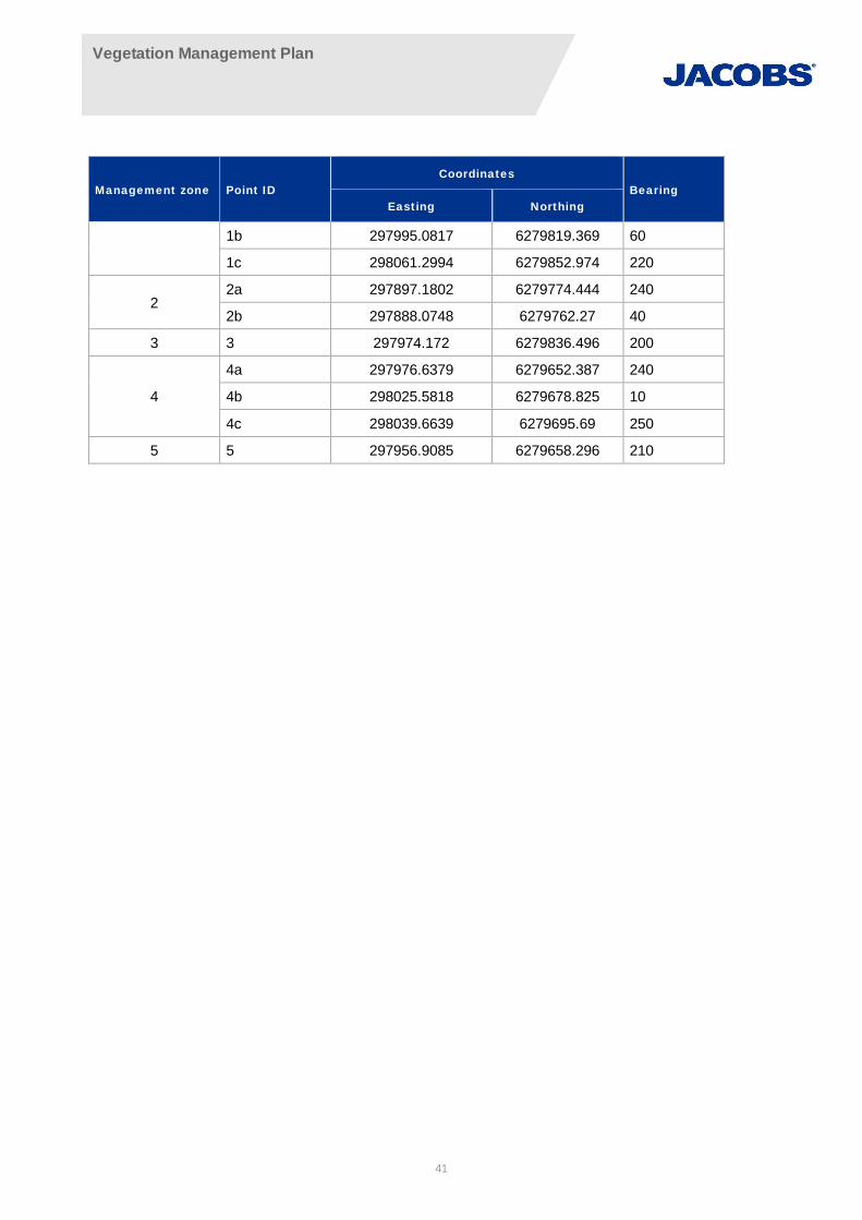
Vegetation Management Plan
41
Management zone Point IDCoordinates
BearingEasting Northing
1b 297995.0817 6279819.369 60
1c 298061.2994 6279852.974 220
22a 297897.1802 6279774.444 240
2b 297888.0748 6279762.27 40
3 3 297974.172 6279836.496 200
4
4a 297976.6379 6279652.387 240
4b 298025.5818 6279678.825 10
4c 298039.6639 6279695.69 250
5 5 297956.9085 6279658.296 210
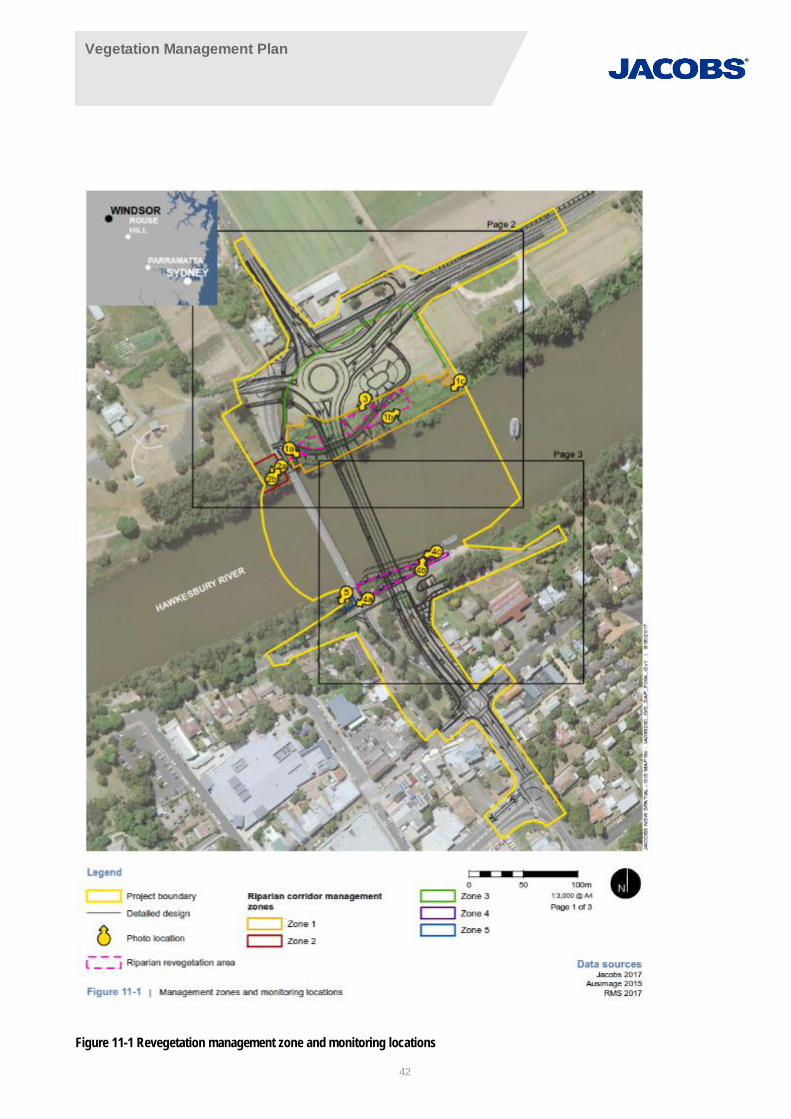
Vegetation Management Plan
42
Figure 11-1 Revegetation management zone and monitoring locations

Vegetation Management Plan
43
11.2 Reporting
Reporting of the outcomes of management actions is important in ensuring their effectiveness. Details ofmanagement actions undertaken during the revegetation project should be recorded along with any subsequentoutcomes.
All contractors should report on all management actions completed during the revegetation project. Thisinformation should be provided monthly to Roads and Maritime and should include details of the area worked,the type of work carried out and any problems encountered. This information should be provided to the ProjectManager, who will regularly brief the relevant staff and management.
Items to be included in the monthly reporting may include, but is not necessarily limited to:
· The revegetation area in which works were conducted
· The number of hours spent in each revegetation area conducting works
· The number of plants installed (during initial planting works)
· The number of staff working on site
· Any comments on the success of revegetation works and any other observations.
The organisation or people responsible for implementation of the revegetation program shall prepare an annualreport on its implementation. Annual reporting shall include but not necessarily limited to a detailed descriptionof all works conducted that year in every revegetation area, suggestions and recommendations for future works,and before and after photographs.
11.3 Success criteria
The Guidelines for vegetation management plans on waterfront land (NSW Office of Water, July 2012a)stipulate that maintenance requirements should extend for a minimum of two years after the completion ofworks or until such time as a minimum 80 per cent survival rate of each species planted and a maximum 5per cent weed cover is present in the treated riparian corridor.
Alternative performance based assessment criteria can indicate the health of the revegetated zone using theLandscape Functional Analysis methodology (Tongway & Hindley 2005).
The Landscape Functional Analysis includes Soil Surface Assessment Indicators such as; perennial vegetationcover; percentage of litter cover and evidence of any erosion which would indicate if the vegetation is sufficientlystabilising the riparian zone.
Erosion increases sediment and alluvium deposits into the waterway and should be a key consideration in themeasure of success to the VPM. Low percentage weed cover is also critical to the establishment of the nativespecies in the revegetated riparian corridor.
Vegetation Management Plan
44
12. ReferencesDepartment of Environment and Conservation (2005), Recovering bushland on the Cumberland Plain - Bestpractice guidelines for the management and restoration of bushland, Department of Environment andConservation, Hurstville.
Department of Environment, Climate Change and Water (DECCW) (2010) Cumberland Plain Recovery Plan,Department of Environment, Climate Change and Water, (NSW), Sydney.
Ecohort Pty Ltd (2011), Estimate of Probable Cost for Proposed Bushland Regeneration Works adjoining AngusCreek at Readymix Rooty Hill Development Site June 2011.
Ensbey, R & Johnson, A (2007), Noxious and Environmental Weed Control Handbook, A Guide to WeedControl in Non-crop, Aquatic and Bushland Situations. 3rd Edition, NSW Department of Primary Industries.
Environment and Resource Sciences (2010), Land Manager’s Monitoring Guide – Photopoint Monitoring, QLDDepartment of Environment and Resource Management.
Florabank (2008), Florabank, viewed 23 October 2008,http://www.florabank.org.au/default.asp?V_DOC_ID=954
Lesryk Environmental Consultants (2002) Flora and Fauna Assessment in Relation to the ProposedConstruction of a Waste Pretreatment Facility, South Windsor, NSW. Report prepared for the Roads and TrafficAuthority by Lesryk Environmental Consultants, Bundeena, NSW.
Mitchell, P.B. (2003). NSW Ecosystems database mapping unit descriptions. Unpublished report to the NSWNational Parks and Wildlife Service, Hurstville.
National Trust of Australia (1999), Bush Regenerators' Handbook, National Trust of Australia, NSW.
National Parks and Wildlife Service (2002). National Biodiversity Audit Biodiversity Strategy Case Study,Cumberland Plain Subregion, Sydney Basin Bioregion, New South Wales, SB8: Cumberland. A report to theNational Land and Water Resources Audit. NSW National Parks & Wildlife Service, Sydney.
NSW Department of Primary Industries (2009), Noxious and Environmental Weed Control Handbook: A guide toweed control in non-crop, aquatic and bushland situations, 6th Edition.
NSW Department of Primary Industries (2013), Fisheries NSW Policy and Guidelines for Fish HabitatConservation and Management (2013 update). Department of Primary Industries.
NSW Office of Water (2010), Guidelines for Controlled Activities: Vegetation Management Plans.
NSW Office of Water (2011), Controlled Activities: Guidelines for riparian corridors.
NSW Office of Water (2012a), Controlled activities on waterfront land – Guidelines for vegetation managementplans on waterfront land.
NSW Office of Water (2012b), Controlled activities on waterfront land – Guidelines for riparian corridors onwaterfront land.
Raine, A.W and Gardiner, J.N (1995), Rivercare: Guidelines for Ecological Sustainable Management of Riversand Riparian Vegetation. LWRRDC, Canberra.
Roads and Traffic Authority (2011a). Biodiversity Guidelines: Protecting and managing biodiversity on RTAprojects. Revision 0/September 2011.

Vegetation Management Plan
45
Roads and Traffic Authority (2011b). Windsor Bridge over the Hawkesbury River Flora and fauna investigations.Unpublished Report. Prepared by LesryK Environmental Consultants in 2008.
Roads and Maritime Services (2017), QA Specification R63 Geotextiles (Separation and Filtration), Edition 4,Revision 1.
Roads and Maritime Services (2015), QA Specification R179. Landscape Planting, Edition 1, Revision 2.
Schirmer, J & Field, J (2000), The Cost of Revegetation, National Heritage Trust, Canberra.
Sinclair Knight Merz (2012), Windsor Bridge Replacement: Flora and fauna working paper.
Sinclair Knight Merz (2013), Windsor Bridge replacement project: Environmental impact statement.
Tongaway, D.J & Hindley, N.L, (2015) Landscape Functional Analysis; Procedures for monitoring landscapes,CSIRO Canberra.
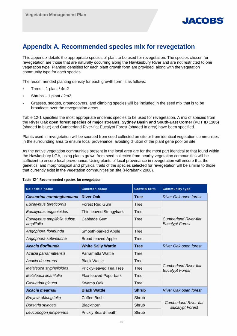
Vegetation Management Plan
46
Appendix A. Recommended species mix for revegetationThis appendix details the appropriate species of plant to be used for revegetation. The species chosen forrevegetation are those that are naturally occurring along the Hawkesbury River and are not restricted to onevegetation type. Planting densities for each plant growth form are provided, along with the vegetationcommunity type for each species.
The recommended planting density for each growth form is as follows:
· Trees – 1 plant / 4m2
· Shrubs – 1 plant / 2m2
· Grasses, sedges, groundcovers, and climbing species will be included in the seed mix that is to bebroadcast over the revegetation areas.
Table 12-1 specifies the most appropriate endemic species to be used for revegetation. A mix of species fromthe River Oak open forest species of major streams, Sydney Basin and South-East Corner (PCT ID 1105)(shaded in blue) and Cumberland River-flat Eucalypt Forest (shaded in grey) have been specified.
Plants used in revegetation will be sourced from seed collected on site or from identical vegetation communitiesin the surrounding area to ensure local provenance, avoiding dilution of the plant gene pool on site.
As the native vegetation communities present in the local area are for the most part identical to that found withinthe Hawkesbury LGA, using plants grown from seed collected from nearby vegetation communities will besufficient to ensure local provenance. Using plants of local provenance in revegetation will ensure that thegenetics, and morphological and physical traits of the species selected for revegetation will be similar to thosethat currently exist in the vegetation communities on site (Florabank 2008).
Table 12-1 Recommended species for revegetation
Scientific name Common name Growth form Community type
Casuarina cunninghamiana River Oak Tree River Oak open forest
Eucalyptus tereticornis Forest Red Gum Tree
Cumberland River-flatEucalypt Forest
Eucalyptus eugenioides Thin-leaved Stringybark Tree
Eucalyptus amplifolia subsp.amplifolia
Cabbage Gum Tree
Angophora floribunda Smooth-barked Apple Tree
Angophora subvelutina Broad-leaved Apple Tree
Acacia floribunda White Sally Wattle Tree River Oak open forest
Acacia parramattensis Parramatta Wattle Tree
Cumberland River-flatEucalypt Forest
Acacia decurrens Black Wattle Tree
Melaleuca styphelioides Prickly-leaved Tea Tree Tree
Melaleuca linariifolia Flax-leaved Paperbark Tree
Casuarina glauca Swamp Oak Tree
Acacia mearnsii Black Wattle Shrub River Oak open forest
Breynia oblongifolia Coffee Bush ShrubCumberland River-flat
Eucalypt ForestBursaria spinosa Blackthorn Shrub
Leucopogon juniperinus Prickly Beard-heath Shrub
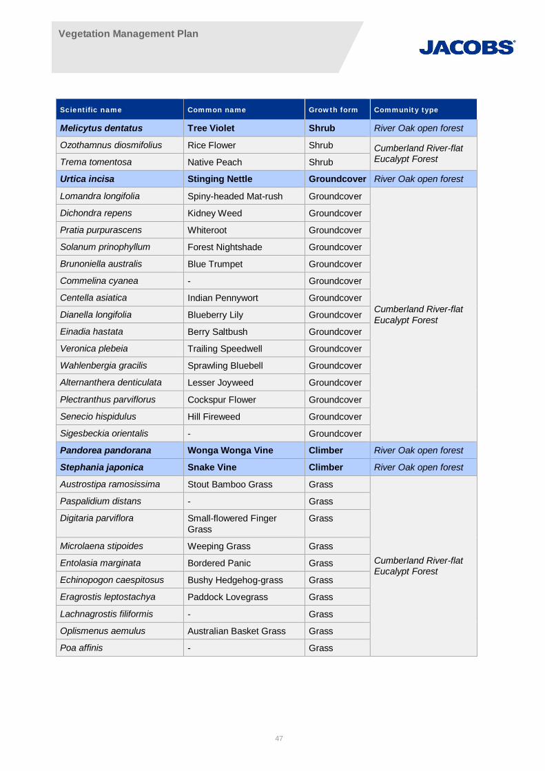
Vegetation Management Plan
47
Scientific name Common name Growth form Community type
Melicytus dentatus Tree Violet Shrub River Oak open forest
Ozothamnus diosmifolius Rice Flower Shrub Cumberland River-flatEucalypt ForestTrema tomentosa Native Peach Shrub
Urtica incisa Stinging Nettle Groundcover River Oak open forest
Lomandra longifolia Spiny-headed Mat-rush Groundcover
Cumberland River-flatEucalypt Forest
Dichondra repens Kidney Weed Groundcover
Pratia purpurascens Whiteroot Groundcover
Solanum prinophyllum Forest Nightshade Groundcover
Brunoniella australis Blue Trumpet Groundcover
Commelina cyanea - Groundcover
Centella asiatica Indian Pennywort Groundcover
Dianella longifolia Blueberry Lily Groundcover
Einadia hastata Berry Saltbush Groundcover
Veronica plebeia Trailing Speedwell Groundcover
Wahlenbergia gracilis Sprawling Bluebell Groundcover
Alternanthera denticulata Lesser Joyweed Groundcover
Plectranthus parviflorus Cockspur Flower Groundcover
Senecio hispidulus Hill Fireweed Groundcover
Sigesbeckia orientalis - Groundcover
Pandorea pandorana Wonga Wonga Vine Climber River Oak open forest
Stephania japonica Snake Vine Climber River Oak open forest
Austrostipa ramosissima Stout Bamboo Grass Grass
Cumberland River-flatEucalypt Forest
Paspalidium distans - Grass
Digitaria parviflora Small-flowered FingerGrass
Grass
Microlaena stipoides Weeping Grass Grass
Entolasia marginata Bordered Panic Grass
Echinopogon caespitosus Bushy Hedgehog-grass Grass
Eragrostis leptostachya Paddock Lovegrass Grass
Lachnagrostis filiformis - Grass
Oplismenus aemulus Australian Basket Grass Grass
Poa affinis - Grass
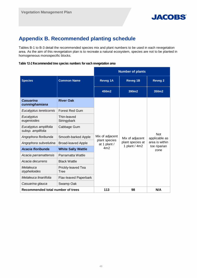
Vegetation Management Plan
48
Appendix B. Recommended planting scheduleTables B-1 to B-3 detail the recommended species mix and plant numbers to be used in each revegetationarea. As the aim of this revegetation plan is to recreate a natural ecosystem, species are not to be planted inhomogeneous monospecific blocks.
Table 12-2 Recommended tree species numbers for each revegetation area
Number of plants
Species Common Name Reveg 1A Reveg 1B Reveg 2
450m2 390m2 350m2
Casuarinacunninghamiana
River Oak
Mix of adjacentplant species
at 1 plant /4m2
Mix of adjacentplant species at
1 plant / 4m2
Notapplicable asarea is withintoe riparian
zone
Eucalyptus tereticornis Forest Red Gum
Eucalyptuseugenioides
Thin-leavedStringybark
Eucalyptus amplifoliasubsp. amplifolia
Cabbage Gum
Angophora floribunda Smooth-barked Apple
Angophora subvelutina Broad-leaved Apple
Acacia floribunda White Sally Wattle
Acacia parramattensis Parramatta Wattle
Acacia decurrens Black Wattle
Melaleucastyphelioides
Prickly-leaved TeaTree
Melaleuca linariifolia Flax-leaved Paperbark
Casuarina glauca Swamp Oak
Recommended total number of trees 113 98 N/A
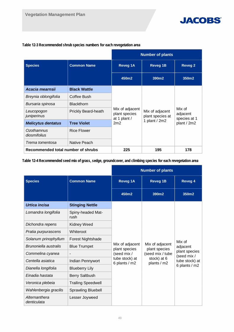
Vegetation Management Plan
49
Table 12-3 Recommended shrub species numbers for each revegetation area
Number of plants
Species Common Name Reveg 1A Reveg 1B Reveg 2
450m2 390m2 350m2
Acacia mearnsii Black Wattle
Mix of adjacentplant speciesat 1 plant /2m2
Mix of adjacentplant species at1 plant / 2m2
Mix ofadjacentspecies at 1plant / 2m2
Breynia oblongifolia Coffee Bush
Bursaria spinosa Blackthorn
Leucopogonjuniperinus
Prickly Beard-heath
Melicytus dentatus Tree Violet
Ozothamnusdiosmifolius
Rice Flower
Trema tomentosa Native Peach
Recommended total number of shrubs 225 195 178
Table 12-4 Recommended seed mix of grass, sedge, groundcover, and climbing species for each revegetation area
Number of plants
Species Common Name Reveg 1A Reveg 1B Reveg 4
450m2 390m2 350m2
Urtica incisa Stinging Nettle
Mix of adjacentplant species(seed mix /tube stock) at6 plants / m2
Mix of adjacentplant species
(seed mix / tubestock) at 6plants / m2
Mix ofadjacentplant species(seed mix /tube stock) at6 plants / m2
Lomandra longifolia Spiny-headed Mat-rush
Dichondra repens Kidney Weed
Pratia purpurascens Whiteroot
Solanum prinophyllum Forest Nightshade
Brunoniella australis Blue Trumpet
Commelina cyanea -
Centella asiatica Indian Pennywort
Dianella longifolia Blueberry Lily
Einadia hastata Berry Saltbush
Veronica plebeia Trailing Speedwell
Wahlenbergia gracilis Sprawling Bluebell
Alternantheradenticulata
Lesser Joyweed
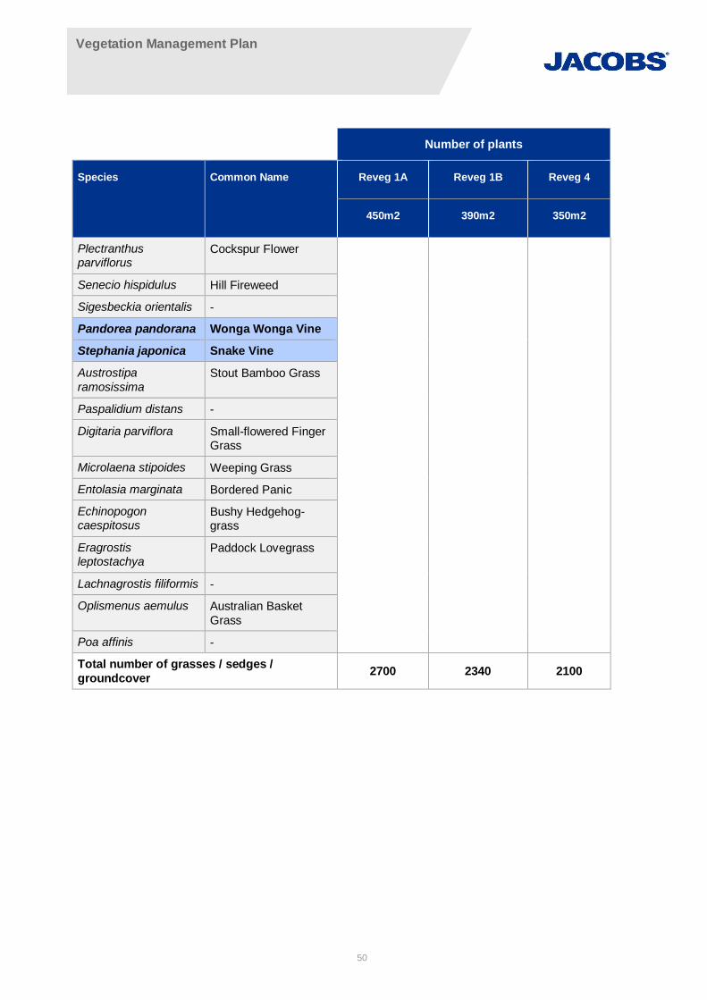
Vegetation Management Plan
50
Number of plants
Species Common Name Reveg 1A Reveg 1B Reveg 4
450m2 390m2 350m2
Plectranthusparviflorus
Cockspur Flower
Senecio hispidulus Hill Fireweed
Sigesbeckia orientalis -
Pandorea pandorana Wonga Wonga Vine
Stephania japonica Snake Vine
Austrostiparamosissima
Stout Bamboo Grass
Paspalidium distans -
Digitaria parviflora Small-flowered FingerGrass
Microlaena stipoides Weeping Grass
Entolasia marginata Bordered Panic
Echinopogoncaespitosus
Bushy Hedgehog-grass
Eragrostisleptostachya
Paddock Lovegrass
Lachnagrostis filiformis -
Oplismenus aemulus Australian BasketGrass
Poa affinis -
Total number of grasses / sedges /groundcover 2700 2340 2100

Vegetation Management Plan
51
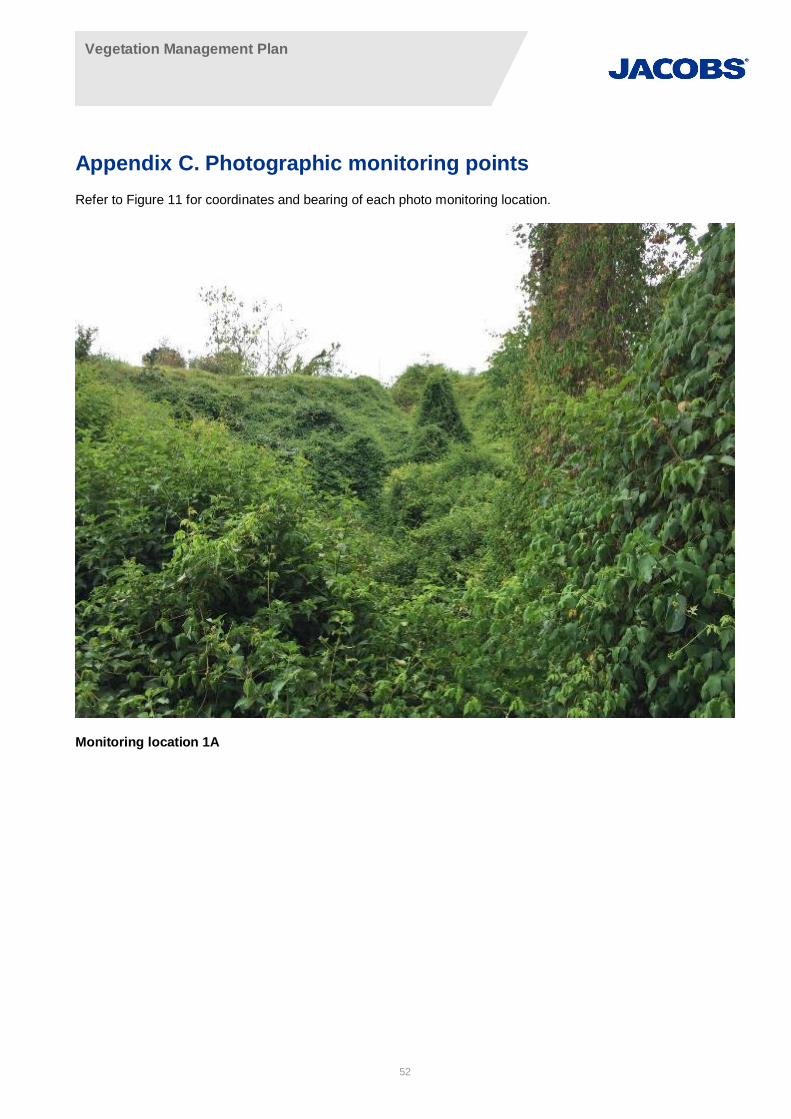
Vegetation Management Plan
52
Appendix C. Photographic monitoring pointsRefer to Figure 11 for coordinates and bearing of each photo monitoring location.
Monitoring location 1A
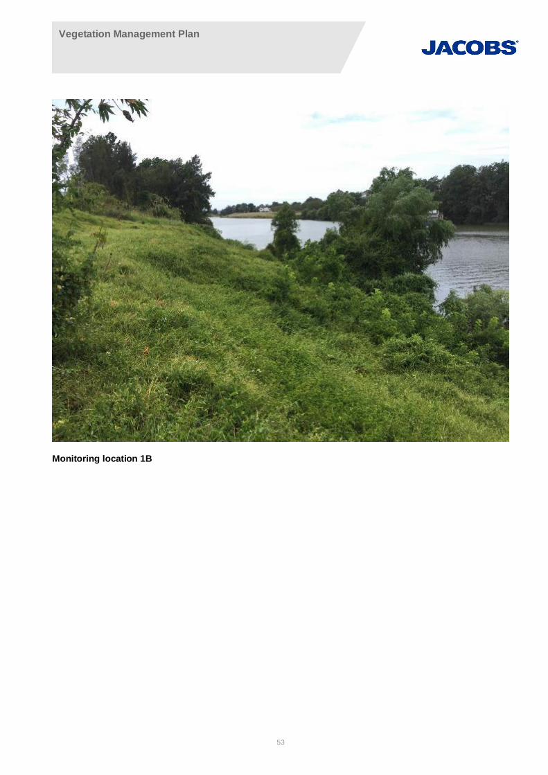
Vegetation Management Plan
53
Monitoring location 1B
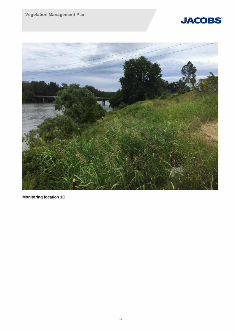
Vegetation Management Plan
54
Monitoring location 1C
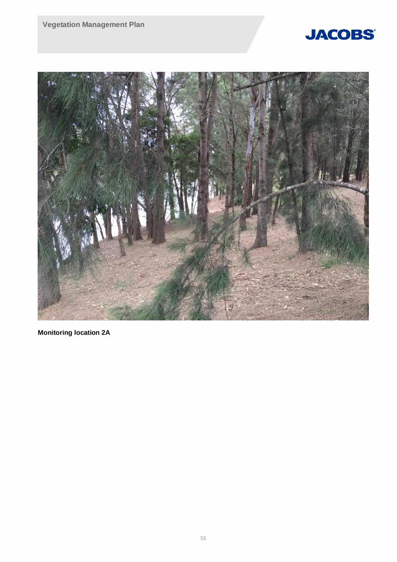
Vegetation Management Plan
55
Monitoring location 2A
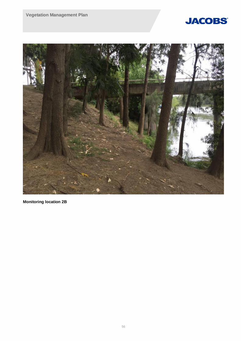
Vegetation Management Plan
56
Monitoring location 2B
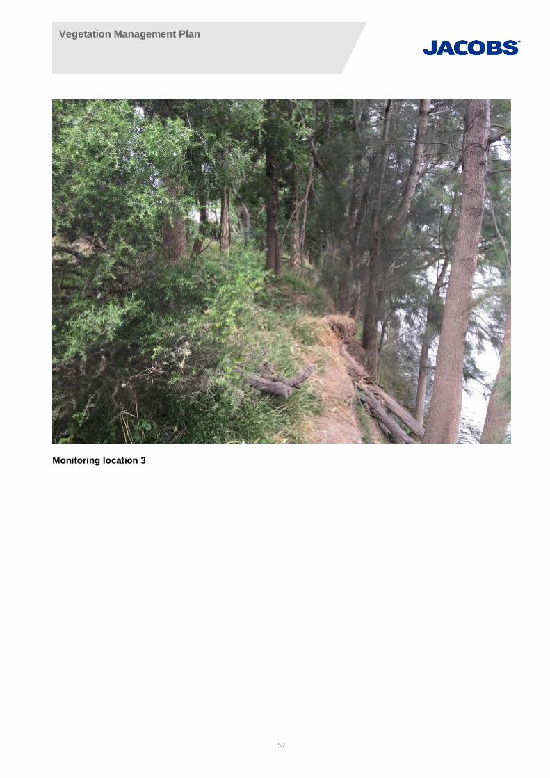
Vegetation Management Plan
57
Monitoring location 3
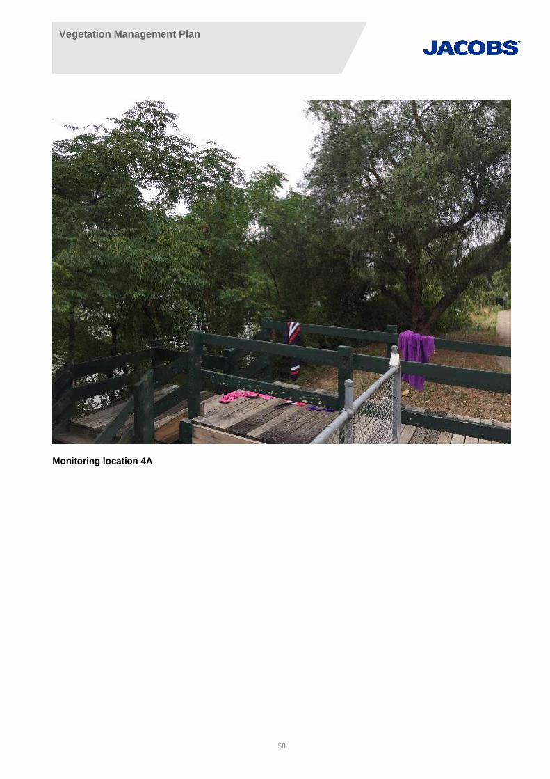
Vegetation Management Plan
58
Monitoring location 4A
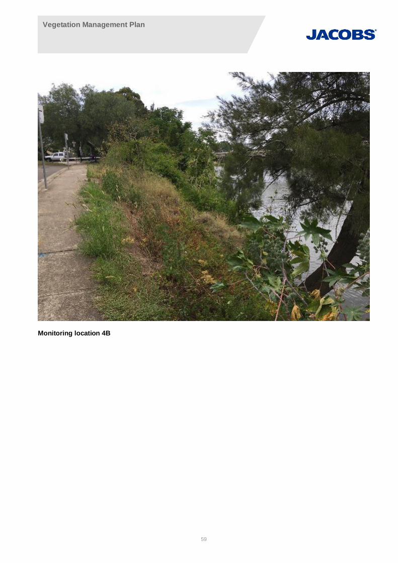
Vegetation Management Plan
59
Monitoring location 4B
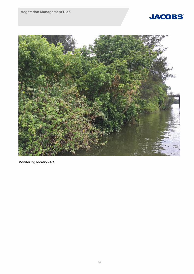
Vegetation Management Plan
60
Monitoring location 4C
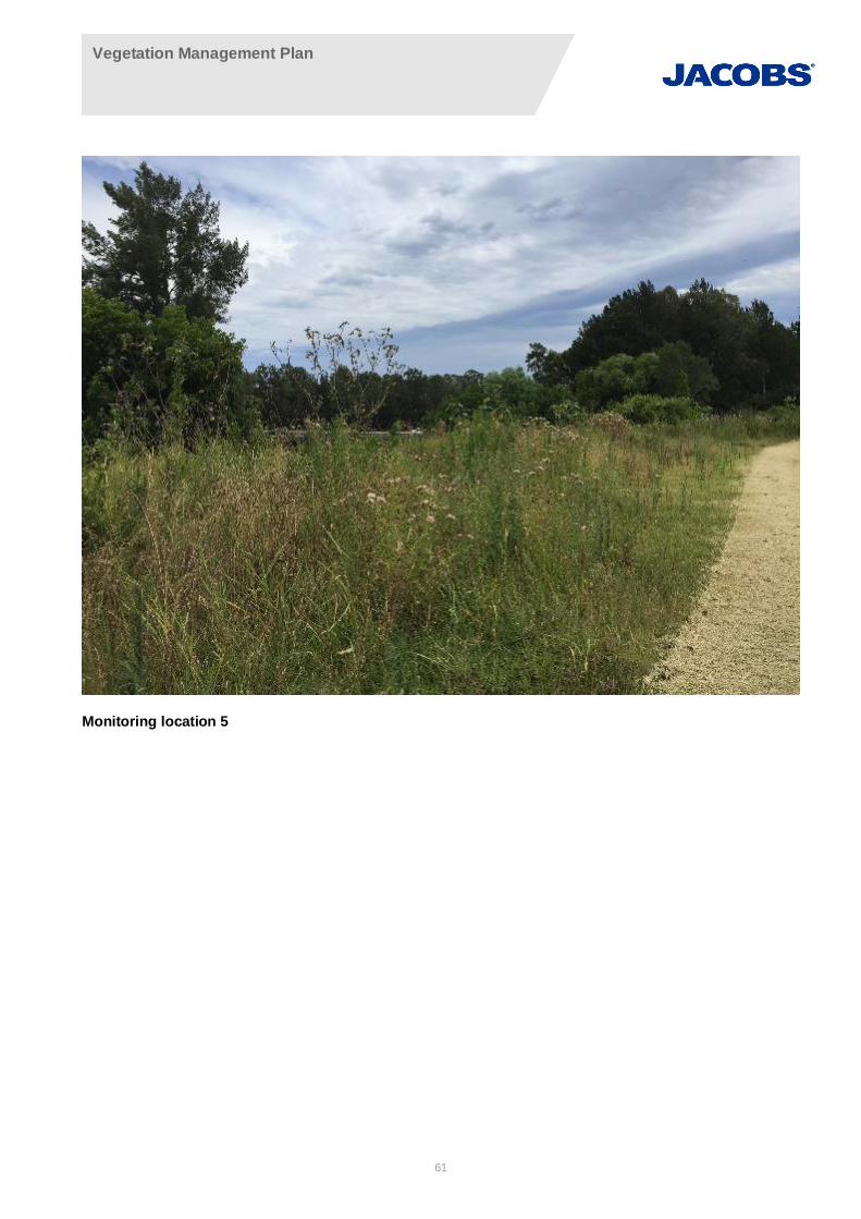
Vegetation Management Plan
61
Monitoring location 5
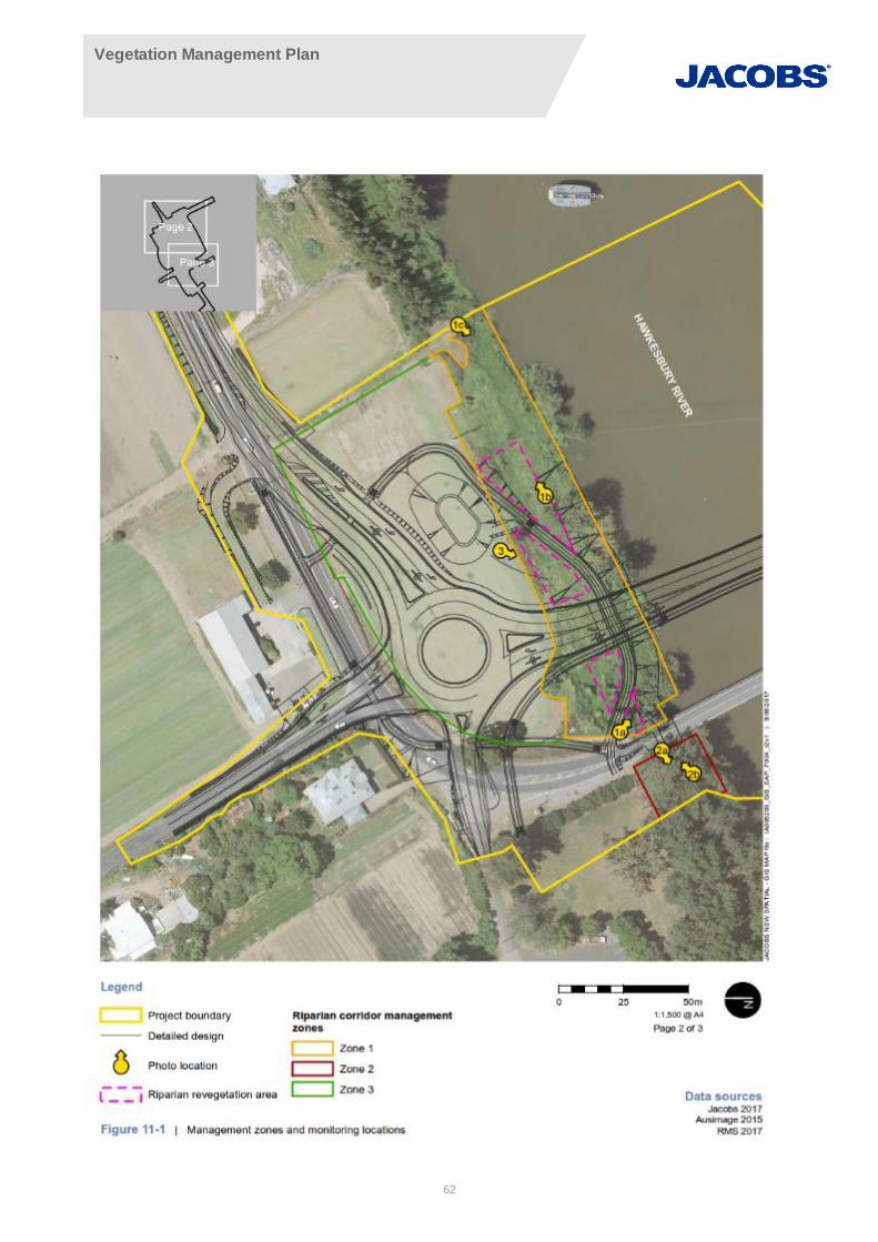
Vegetation Management Plan
62
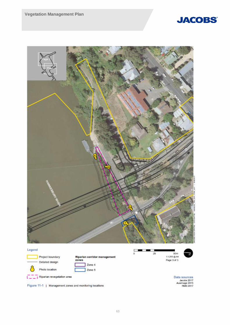
Vegetation Management Plan
63