Embed Size (px)
Citation preview
1
DemonstrationTestCatchments
Newsletter-Winter2015/16
WelcometotheWinter2015/16editionoftheDTCNewsletterhighlightingsomeaspectsofthe
research,recentkeyactivities,eventsandinformationonrelatedprojectswithlinksforyouto
followuponmoredetailedinformationaboutindividualitemsandtopicsofinterest.
If we knew what we were doing it would not be called research, would it?
– Albert Einstein
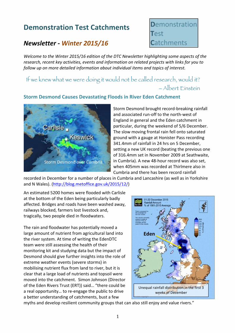
StormDesmondCausesDevastatingFloodsinRiverEdenCatchment
• StormDesmondbroughtrecord-breakingrainfallandassociatedrun-offtothenorth-westofEnglandingeneralandtheEdencatchmentinparticular,duringtheweekendof5/6December.TheslowmovingfrontalrainfellontosaturatedgroundwithagaugeatHonisterPassrecording341.4mmofrainfallin24hrson5December,settinganewUKrecord(beatingthepreviousoneof316.4mmsetinNovember2009atSeathwaite,inCumbria).Anew48-hourrecordwasalsoset,when405mmwasrecordedatThirlmerealsoinCumbriaandtherehasbeenrecordrainfall
recordedinDecemberforanumberofplacesinCumbriaandLancashire(aswellasinYorkshireandNWales).(http://blog.metoffice.gov.uk/2015/12/)
Anestimated5200homeswerefloodedwithCarlisleatthebottomoftheEdenbeingparticularlybadlyaffected.Bridgesandroadshavebeenwashedaway,railwaysblocked,farmerslostlivestockand,tragically,twopeoplediedinfloodwaters.Therainandfloodwaterhaspotentiallymovedalargeamountofnutrientfromagriculturallandintotheriversystem.AttimeofwritingtheEdenDTCteamwerestillassessingthehealthoftheirmonitoringkitandstudyingdatabuttheimpactofDesmondshouldgivefurtherinsightsintotheroleofextremeweatherevents(severestorms)inmobilisingnutrientfluxfromlandtoriver,butitisclearthatalargeloadofnutrientsandtopsoilweremovedintothecatchment.SimonJohnson(DirectoroftheEdenRiversTrust(ERT))said…“therecouldbearealopportunity…tore-engagethepublictodriveabetterunderstandingofcatchments,bustafewmythsanddevelopresilientcommunitygroupsthatcanalsostillenjoyandvaluerivers.”
StormDesmondoverCumbria
Unequalrainfalldistributioninthefirst3weeksofDecember
Eden
2
AddressingaquestionfromtheEnvironmentAgencyastowhethersoilmanagementhadaroletoplayintheseverityoftheflooding,ProfessorPhilHaygarthsummarisedhisthoughtsin4categories:
1. Thereisevidenceattheplotandfieldscalethatsoilmanagement,whichpromotesstructureandwaterretention,canslowwaterrun-off.
2. Theextenttowhichthisknowledgecanbeconfidentlytranslatedtothemitigationoffloodingeventsatthecatchmentscaleismuchlessclear,catchmentsarecomplex.
3. Soilstructuralmanagementintheuplandscancontributetoreducedrun-offbutmustbepartofabiggerandintegratedsolution.
4. ItappearsthattheeventsinCumbriaduringStormDesmondweresoseverethatsoilissuesprobablywouldhavebeenofmarginalimportanceinthiscase.
Isthereevidenceof‘biogeochemicalstationarity’intheRiverWensum
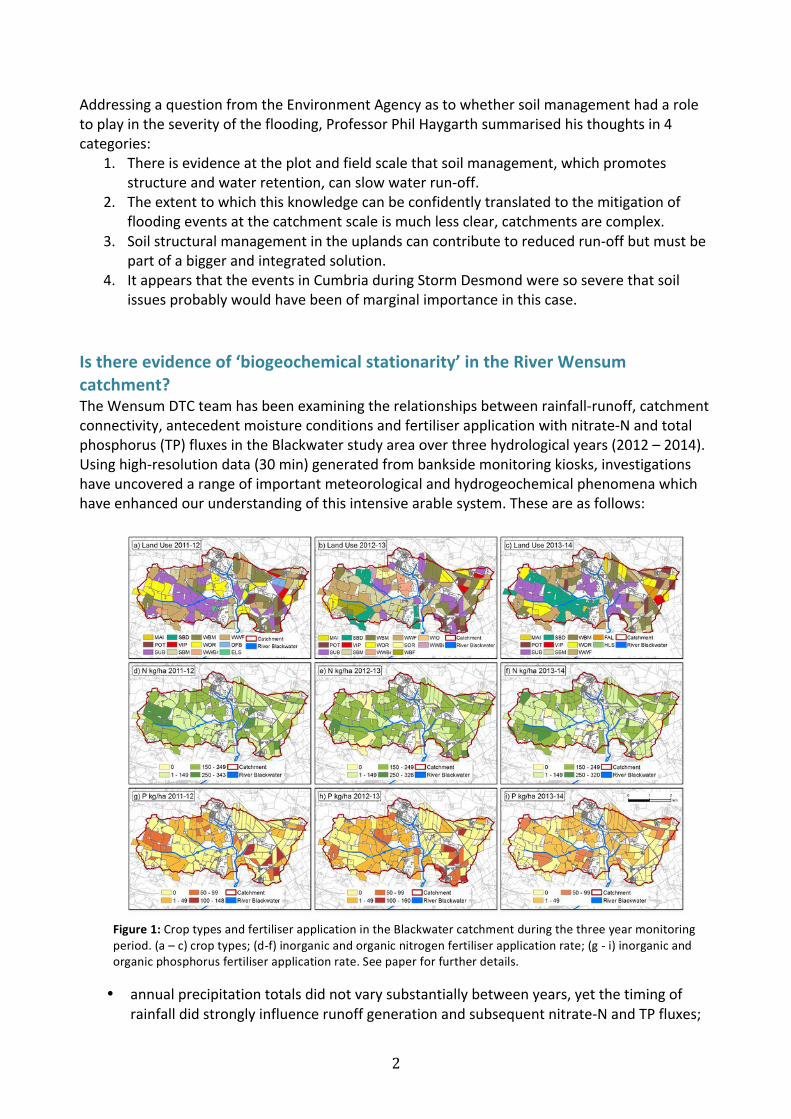
catchment?TheWensumDTCteamhasbeenexaminingtherelationshipsbetweenrainfall-runoff,catchmentconnectivity,antecedentmoistureconditionsandfertiliserapplicationwithnitrate-Nandtotalphosphorus(TP)fluxesintheBlackwaterstudyareaoverthreehydrologicalyears(2012–2014).Usinghigh-resolutiondata(30min)generatedfrombanksidemonitoringkiosks,investigationshaveuncoveredarangeofimportantmeteorologicalandhydrogeochemicalphenomenawhichhaveenhancedourunderstandingofthisintensivearablesystem.Theseareasfollows:
• annualprecipitationtotalsdidnotvarysubstantiallybetweenyears,yetthetimingofrainfalldidstronglyinfluencerunoffgenerationandsubsequentnitrate-NandTPfluxes;
Figure1:CroptypesandfertiliserapplicationintheBlackwatercatchmentduringthethreeyearmonitoringperiod.(a–c)croptypes;(d-f)inorganicandorganicnitrogenfertiliserapplicationrate;(g-i)inorganicandorganicphosphorusfertiliserapplicationrate.Seepaperforfurtherdetails.
3
• thegreatestnitrate-NandTPfluxesoccurredonlywhentheshallowgroundwaterlevelwaswithin0.6mofthegroundsurfaceandrunoffcoefficientsweregreaterthan0.1;
• thewetwinter2013resultedinelevatedshallowgroundwaterlevelswhichledtomorefrequentactivationofsub-surfacepathwaysandtiledrainflows;
• acrossthethreeyears,dryantecedentconditionshadatemporaryeffectinelevatingTPloads;
• evidenceofTPsourceexhaustionafterconsecutivestormeventswasdetectedandcanbeattributedtotherepeateddepletionoftemporarilyconnectedcriticalsourceareastotherivernetworkviaimpermeableroadsurfaces;
• finally,andmostimportantly,fertiliserapplicationvariedconsiderably(upto41%)acrossthethreeyearsduetodifferencesincroprotationbetweenfarms.However,proportionalreductionsinannualriverinenitrate-NandTPloadingswerenotobservedatthesub-catchmentoutlet.Nitrateloadingswereslightlyhigherduringfertiliserapplication,buttherewaslittlerelationshipbetweenPfertiliserapplicationandriverineTPload.Theseresultsindicatethatthisintensivearablecatchmentmaybeinastateof‘biogeochemicalstationarity’,wherebylegacystoresofnutrientsarebufferingthestreamagainstannualchangesinfertilisernutrientinputs.
FurtherdetailsonthisresearchcanbefoundinarecentlypublishedarticleinScienceoftheTotalEnvironment:OutramFN,CooperRJ,SünnenbergG,HiscockKM,LovettAA.2015.Antecedentconditions,hydrologicalconnectivityandanthropogenicinputs:Factorsaffectingnitrateandphosphorustransferstoagriculturalheadwaterstreams.ScienceoftheTotalEnvironment.DOI:10.1016/j.scitotenv.2015.12.025.Contact:RichardCooper([email protected])
DTCDataandtheDataArchive
TheDemonstrationTestCatchmentArchiveProjectfinishedattheendofJanuary2015.TheoutcomeoftheprojectwastheAgriculturalandEnvironmentalDataArchive(AEDA),whichhasbeenonlinefornearlyayearandcanbeaccessedatwww.environmentdata.org.Varioususershavebeenaddingdatasincethattime,notonlyfromtheDTCconsortiaandtheDefraAgriculturalGreenhouseGasPlatform,butalsofromtheFreshwaterBiologicalAssociationwhobuiltandhousethearchive,andothercontributorssuchasSyngenta,theEnvironmentAgencyandTheAtlanticSalmonTrust.TherearealsosomenewcontributorsfromtheDefraSustainableIntensificationPlatformandsomehistoricalGreenhouseGasdata.Addingdatatothearchiveisonlythefirststepinmakingitavailabletothepublic.Oncethedatahasbeenaddedintheproperformatitcanbepublished.Publicationinvolvessubmittingthedataforaseriesofautomatedchecksbythearchivesoftwareandalsohumanreviewbythearchivestaff.Ifalliswellitwillbepublishedandmadeavailabletothepublic,aDigitalObjectIdentifier(DOI)iscreatedforthedatasetanditbecomesascholarlyworkwhichcanbecitedinscientificpublications.YoucanseeexamplesofsomepublishedDTCdataat:http://www.environmentdata.org/clist/dtcwensum.Intheelevenmonthssincethearchivewasmadeavailableseveralimprovementshavebeenmadethatshouldmakeiteasierforpeopletoadddatatothearchive.TheDOIcreationfunctionalityhasbeenaddedandthequalityofthepublisheddatainthearchivehasbeenenhancedbymakingitpossibletoachievecertificationfromtheOpenDataInstitute(ODI).More
4
andmoredatawillbeaddedtothearchiveastimegoesonandthetechnicalcapabilitiesofthesystemwillbeimprovedonacontinuousbasis.Contact:MikeHaft([email protected]).
TheUseofRemoteSensingTechniquesinUnderstandingDiffusePollution
TheDTCteams,intheEdencatchmentparticularly,havebeentriallingavarietyofremotesensingtechniquestoseeiftheycanaddvalueinunderstandingthecatchmentsystem.Inthefollowingfewarticlessomeofthisworkissummarised.
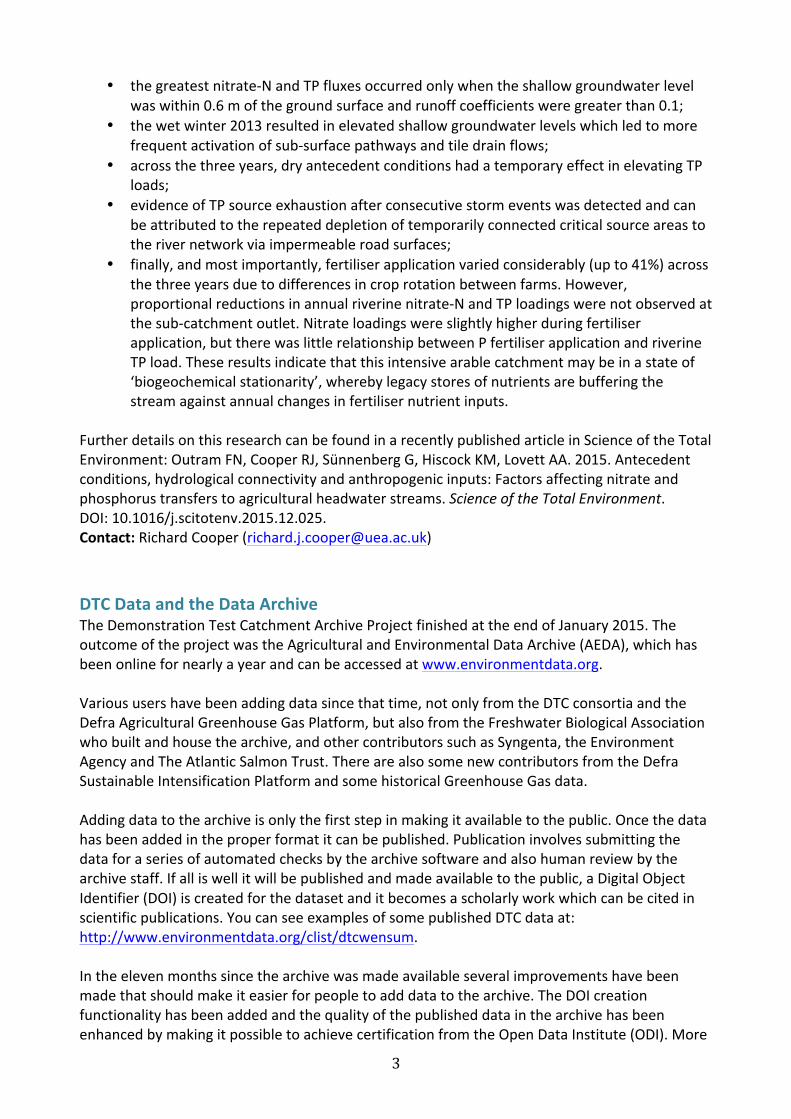
RealTimeCameraWorkAsetofcustom-maderealtimewebcameraswereinstalledateachoftheEdenDTCcatchmentoutletsaspartofthefirstphaseoftheDTCproject.ThesecamerascapturedVideoGraphicsArray(VGA)low-resolutionimages(640x680pixels)at10minuteintervals,whichweretransmittedtotheweb-serverviathemobilephonedatanetwork.TheimagesweredisplayedontheEdenDTCwebsiteandarchivedforfutureanalysis.Theobjectivesforthisinstallationwere:
• Toallowthefieldteamtoseethecurrentconditionsatthesitestoassistwithmaintenance;and
• Toallowstakeholderstoseethesitesandcomparethemonitoringresultstotheoutvisualrecord.
Theliveimagesfromtheweb-camswerepopularonthewebsite.Forexample,thecameraattheMorlandoutletwasviewed245timesin2013,whilethewaterchemistrydatawasviewed320times,indicatingthattheusersofthewebsitewerefindingvalueintheseimages.Thecamerasalsocapturedsomeexemplarstormeventsandstreamresponses(Fig2).
Therewereproblemswiththereliabilityofthecameras,requiringfrequentattentiontokeepthemrunning.Therewerealsoissueswithalackof3GmobiledatasignalattheThackthwaiteBecksite.Ultimately,theperformanceofthecameraswasnotsufficienttojustifythecontinuedtimecostofmaintainingthesystem;(thecamerasupplierhassincebeenboughtoutbyMeteorCommunications,whohaveupdatedandrefinedthecamerasintoanewproduct).
Figure2:StormflowresponsecapturedatThackthwaiteBeckwiththerealtimewebcameras
5
Conclusions• Thereal-timecamerasprovidedusefulcontextualinformationtoboththefieldteamand
towebsiteusers;• Theeventscapturedbythecamerashavesupportedpresentationsontheproject;• Thequalityandlevelofmaintenancerequiredforthecamerasmeantthattheywereon
trialforpartoftheproject;• Futureprojectscouldconsiderinstallingnewversionsofthistechnologyifthequalitycan
beimprovedandmaintenancerequiredcanbereduced. MonitoringCattlewithCameras–Exploringthetemporaldynamicsbetweencattlein-stream
presenceandsuspendedsolidsinaheadwatercatchmentCattlein-streamactivityispotentiallyanimportantcontributortowaterpollutionfromagriculture.Inordertoaddresstheuncertaintyabouttheextenttowhichcattleimpactonsedimenttransferprocesseswithinthefluvialchannel,acomparisonofhigh-resolutionmonitoringdataofcattleactivitywithinthestreambedagainsthigh-resolutionwaterqualitydatacollectedoveraperiodofseveralmonthswasconducted.BushnellTrophyXLT119455motionsensorcameras,withinfrarednight-visionLEDs,wereusedtocapturein-streamactivityofcattle,withatime-delayof10secondsbetweeneachshutterresponsetriggeredbythemotionsensors.inanunfencedreachoverafour-monthperiod.Resultswerecomparedagainsthigh-resolutionSSCdata.Overthedaysthatcattlegrazedthefield,58%oftheinstanceswhensuspendedsolidsconcentrations(SSC)crossedthe25mgl-1FreshwaterFishDirectiveguidelinethresholdcanbeattributedtocattlepresenceinthestream.Flowwasthemaindriveroftotalsedimentstransportedoverthestudyperiod,andnorelationshipwasfoundbetweenSSCandtheabsolutenumberofcattlefeetinthewater.Hysteresisanalysisindicateda‘first-flush’oflocalsedimentsrapidlymobilisedduringthenon-cattlerelatedSSCevents,aresultofcattleproximitytochannelmargins.Resultsdemonstrateatemporallagbetweencattlein-streampresenceandacriticalamountoftheircontributiontosedimentload,andthatmonitoringonlyinstantaneouslywithcattleactivitymayleadtounderestimationoftheirpollutionimpact.Theworkhighlightsthatcattlehaveanobservableimpactonwaterpollution,althoughatemporallagbetweencattlein-streampresenceandacriticalamountoftheircontributiontosedimentloadwasdemonstrated.Thisstudyhelpsdemonstratethelossofenvironmentalinformationthatcanresultfromlowresolutionmonitoringprogrammes,andisavailableinfullathttp://pubs.rsc.org/en/content/articlepdf/2014/em/c3em00686g?page=search.Monitoringchangesindiffusepollutionsourceriskwithtime-lapsephotographyTherearemanyfactorswithinthelandscapethatcanaffectdiffusepollutionsourcerisks,whichvaryovertheyear.Examplesincludesnowcoverdynamicsdrivingoverlandflownotdirectlyconnectedtoprecipitationonthatday,andchangesinsolarreceiptresultingfromcloudcoverandlandcoverchangesensuingfromagriculturalpractices.AnapproachthatwastrialledwithinthefirstphaseofDTCwastheuseofatime-lapsecameratocreateavisualrecordonthelandscape,whichcouldthenbeprocessedtogiveacontinuousrecordofsuchfactors.Itishopedthatthisextrainformationmayprovideusefulcontextandbackgroundinformationfortheinterpretationofthein-streammonitoringdata.
6
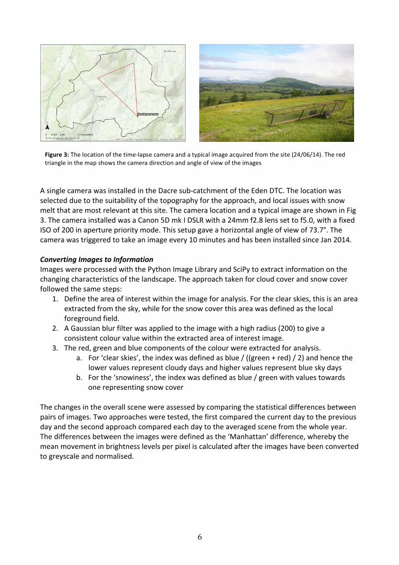
AsinglecamerawasinstalledintheDacresub-catchmentoftheEdenDTC.Thelocationwasselectedduetothesuitabilityofthetopographyfortheapproach,andlocalissueswithsnowmeltthataremostrelevantatthissite.ThecameralocationandatypicalimageareshowninFig3.ThecamerainstalledwasaCanon5DmkIDSLRwitha24mmf2.8lenssettof5.0,withafixedISOof200inapertureprioritymode.Thissetupgaveahorizontalangleofviewof73.7°.Thecamerawastriggeredtotakeanimageevery10minutesandhasbeeninstalledsinceJan2014.ConvertingImagestoInformationImageswereprocessedwiththePythonImageLibraryandSciPytoextractinformationonthechangingcharacteristicsofthelandscape.Theapproachtakenforcloudcoverandsnowcoverfollowedthesamesteps:
1. Definetheareaofinterestwithintheimageforanalysis.Fortheclearskies,thisisanareaextractedfromthesky,whileforthesnowcoverthisareawasdefinedasthelocalforegroundfield.
2. AGaussianblurfilterwasappliedtotheimagewithahighradius(200)togiveaconsistentcolourvaluewithintheextractedareaofinterestimage.
3. Thered,greenandbluecomponentsofthecolourwereextractedforanalysis.a. For‘clearskies’,theindexwasdefinedasblue/((green+red)/2)andhencethe
lowervaluesrepresentcloudydaysandhighervaluesrepresentblueskydaysb. Forthe‘snowiness’,theindexwasdefinedasblue/greenwithvaluestowards
onerepresentingsnowcoverThechangesintheoverallscenewereassessedbycomparingthestatisticaldifferencesbetweenpairsofimages.Twoapproachesweretested,thefirstcomparedthecurrentdaytothepreviousdayandthesecondapproachcomparedeachdaytotheaveragedscenefromthewholeyear.Thedifferencesbetweentheimagesweredefinedasthe‘Manhattan’difference,wherebythemeanmovementinbrightnesslevelsperpixeliscalculatedaftertheimageshavebeenconvertedtogreyscaleandnormalised.
Figure3:Thelocationofthetime-lapsecameraandatypicalimageacquiredfromthesite(24/06/14).Theredtriangleinthemapshowsthecameradirectionandangleofviewoftheimages
7
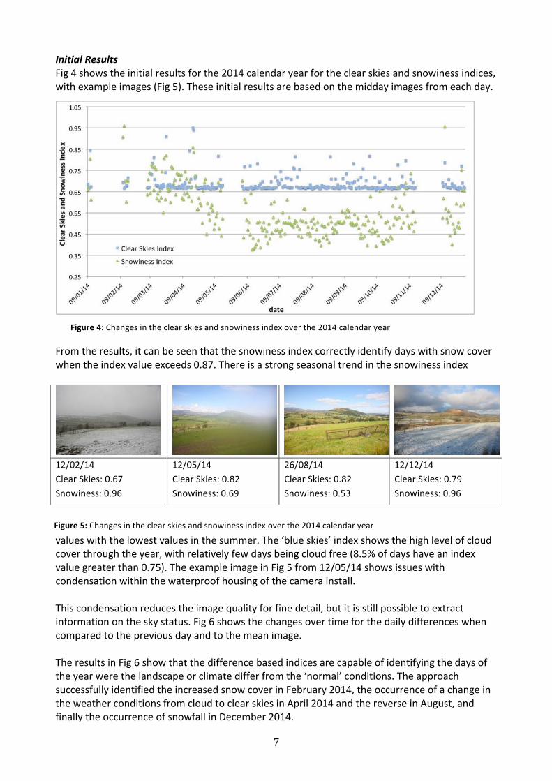
InitialResultsFig4showstheinitialresultsforthe2014calendaryearfortheclearskiesandsnowinessindices,withexampleimages(Fig5).Theseinitialresultsarebasedonthemiddayimagesfromeachday.
Fromtheresults,itcanbeseenthatthesnowinessindexcorrectlyidentifydayswithsnowcoverwhentheindexvalueexceeds0.87.Thereisastrongseasonaltrendinthesnowinessindex
12/02/14ClearSkies:0.67Snowiness:0.96
12/05/14ClearSkies:0.82Snowiness:0.69
26/08/14ClearSkies:0.82Snowiness:0.53
12/12/14ClearSkies:0.79Snowiness:0.96
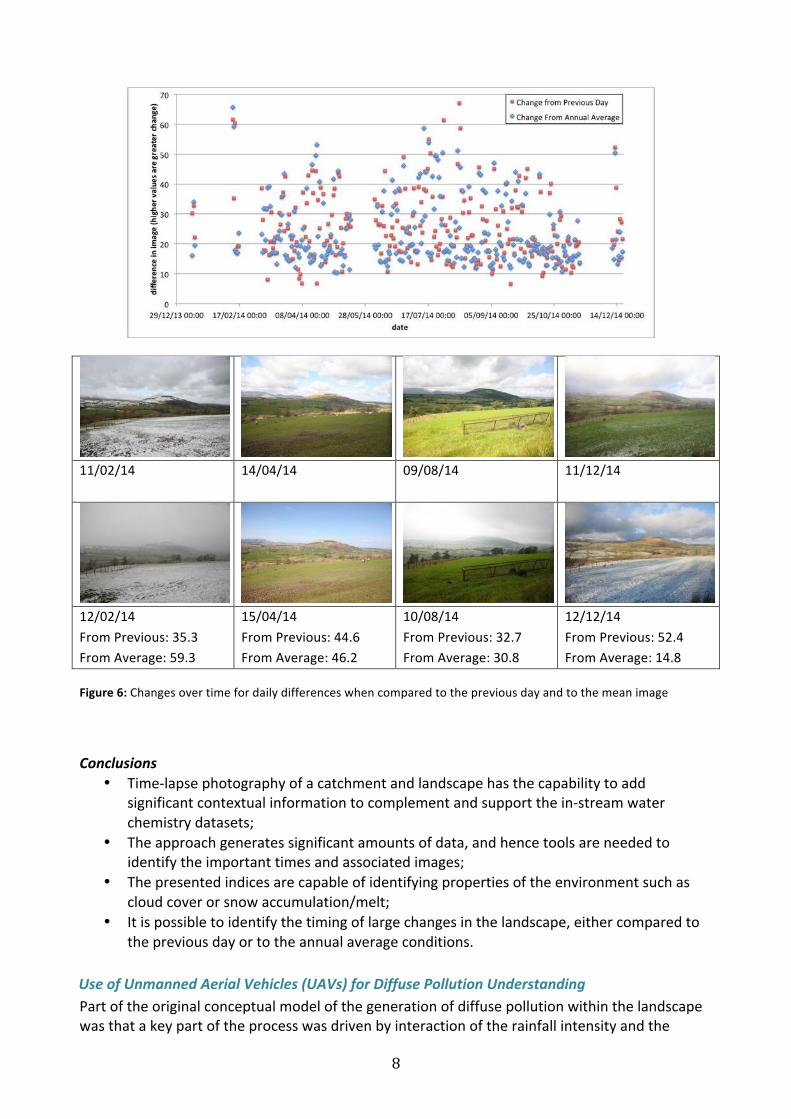
valueswiththelowestvaluesinthesummer.The‘blueskies’indexshowsthehighlevelofcloudcoverthroughtheyear,withrelativelyfewdaysbeingcloudfree(8.5%ofdayshaveanindexvaluegreaterthan0.75).TheexampleimageinFig5from12/05/14showsissueswithcondensationwithinthewaterproofhousingofthecamerainstall.Thiscondensationreducestheimagequalityforfinedetail,butitisstillpossibletoextractinformationontheskystatus.Fig6showsthechangesovertimeforthedailydifferenceswhencomparedtothepreviousdayandtothemeanimage.TheresultsinFig6showthatthedifferencebasedindicesarecapableofidentifyingthedaysoftheyearwerethelandscapeorclimatedifferfromthe‘normal’conditions.TheapproachsuccessfullyidentifiedtheincreasedsnowcoverinFebruary2014,theoccurrenceofachangeintheweatherconditionsfromcloudtoclearskiesinApril2014andthereverseinAugust,andfinallytheoccurrenceofsnowfallinDecember2014.
Figure4:Changesintheclearskiesandsnowinessindexoverthe2014calendaryear
Figure5:Changesintheclearskiesandsnowinessindexoverthe2014calendaryear
8
11/02/14
14/04/14
09/08/14
11/12/14
12/02/14FromPrevious:35.3FromAverage:59.3
15/04/14FromPrevious:44.6FromAverage:46.2
10/08/14FromPrevious:32.7FromAverage:30.8
12/12/14FromPrevious:52.4FromAverage:14.8
Figure6:Changesovertimefordailydifferenceswhencomparedtothepreviousdayandtothemeanimage
Conclusions• Time-lapsephotographyofacatchmentandlandscapehasthecapabilitytoadd
significantcontextualinformationtocomplementandsupportthein-streamwaterchemistrydatasets;
• Theapproachgeneratessignificantamountsofdata,andhencetoolsareneededtoidentifytheimportanttimesandassociatedimages;
• Thepresentedindicesarecapableofidentifyingpropertiesoftheenvironmentsuchascloudcoverorsnowaccumulation/melt;
• Itispossibletoidentifythetimingoflargechangesinthelandscape,eithercomparedtothepreviousdayortotheannualaverageconditions.
UseofUnmannedAerialVehicles(UAVs)forDiffusePollutionUnderstandingPartoftheoriginalconceptualmodelofthegenerationofdiffusepollutionwithinthelandscapewasthatakeypartoftheprocesswasdrivenbyinteractionoftherainfallintensityandthe
9
statusofthelandsurface.Landsurfacecharacteristicschangesignificantlyonintra-andinter-annualtimescalesandhence,tounderstandthecatchmentresponsetoastormevent,knowledgeofthecurrentstatusofthelandscapeisneeded.Tomonitorthesechanges,variousremotesensingapproacheswereassessed.Bothsatellitebasedremotesensingandaerialphotographywerediscountedduetoprohibitivecostsandpotentialissueswithcloudcover.Therefore,aspatiallytargetedplanusingaUAVwasdevelopedasawaytogetsomeinformationonthelandscapestate.
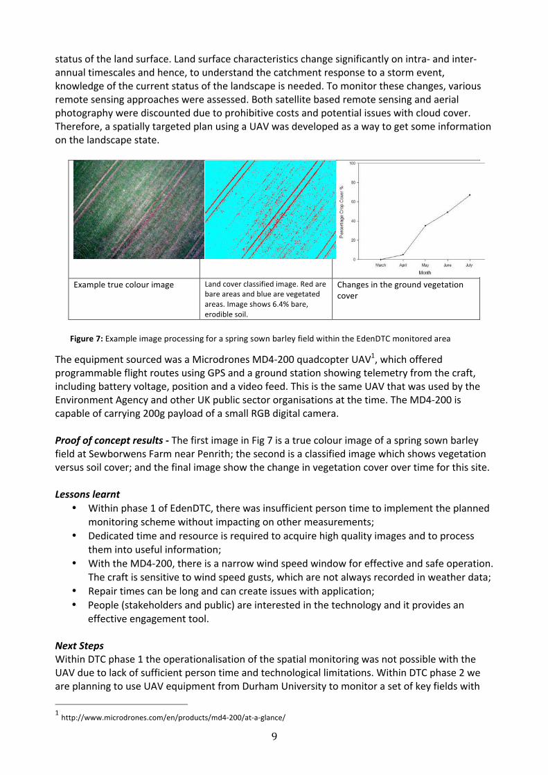
Exampletruecolourimage Landcoverclassifiedimage.Redare
bareareasandbluearevegetatedareas.Imageshows6.4%bare,erodiblesoil.
Changesinthegroundvegetationcover
TheequipmentsourcedwasaMicrodronesMD4-200quadcopterUAV1,whichofferedprogrammableflightroutesusingGPSandagroundstationshowingtelemetryfromthecraft,includingbatteryvoltage,positionandavideofeed.ThisisthesameUAVthatwasusedbytheEnvironmentAgencyandotherUKpublicsectororganisationsatthetime.TheMD4-200iscapableofcarrying200gpayloadofasmallRGBdigitalcamera.
Proofofconceptresults-ThefirstimageinFig7isatruecolourimageofaspringsownbarleyfieldatSewborwensFarmnearPenrith;thesecondisaclassifiedimagewhichshowsvegetationversussoilcover;andthefinalimageshowthechangeinvegetationcoverovertimeforthissite.
Lessonslearnt• Withinphase1ofEdenDTC,therewasinsufficientpersontimetoimplementtheplanned
monitoringschemewithoutimpactingonothermeasurements;• Dedicatedtimeandresourceisrequiredtoacquirehighqualityimagesandtoprocess
themintousefulinformation;• WiththeMD4-200,thereisanarrowwindspeedwindowforeffectiveandsafeoperation.
Thecraftissensitivetowindspeedgusts,whicharenotalwaysrecordedinweatherdata;• Repairtimescanbelongandcancreateissueswithapplication;• People(stakeholdersandpublic)areinterestedinthetechnologyanditprovidesan
effectiveengagementtool.
NextStepsWithinDTCphase1theoperationalisationofthespatialmonitoringwasnotpossiblewiththeUAVduetolackofsufficientpersontimeandtechnologicallimitations.WithinDTCphase2weareplanningtouseUAVequipmentfromDurhamUniversitytomonitorasetofkeyfieldswith1http://www.microdrones.com/en/products/md4-200/at-a-glance/
Figure7:ExampleimageprocessingforaspringsownbarleyfieldwithintheEdenDTCmonitoredarea
10
higherosionriskandeffectivepathways(strongconnectivity)totheriverchannels.Thenewequipment(DJIS1000withZenmusegimbal,carryinga24mpAPS-CRGBcamera)iscapableofflyinginfarhigherwindspeedsandcancapturehigherresolutionandhigherprecisionimages.Theseimprovedimageswillenabledetailedterrainmodelsandcovermapsforthehotspotfieldstobecreated.Exampleswillbeshowninfutureprojectupdates.
Farmer-LedMonitoringintheWensumDTC
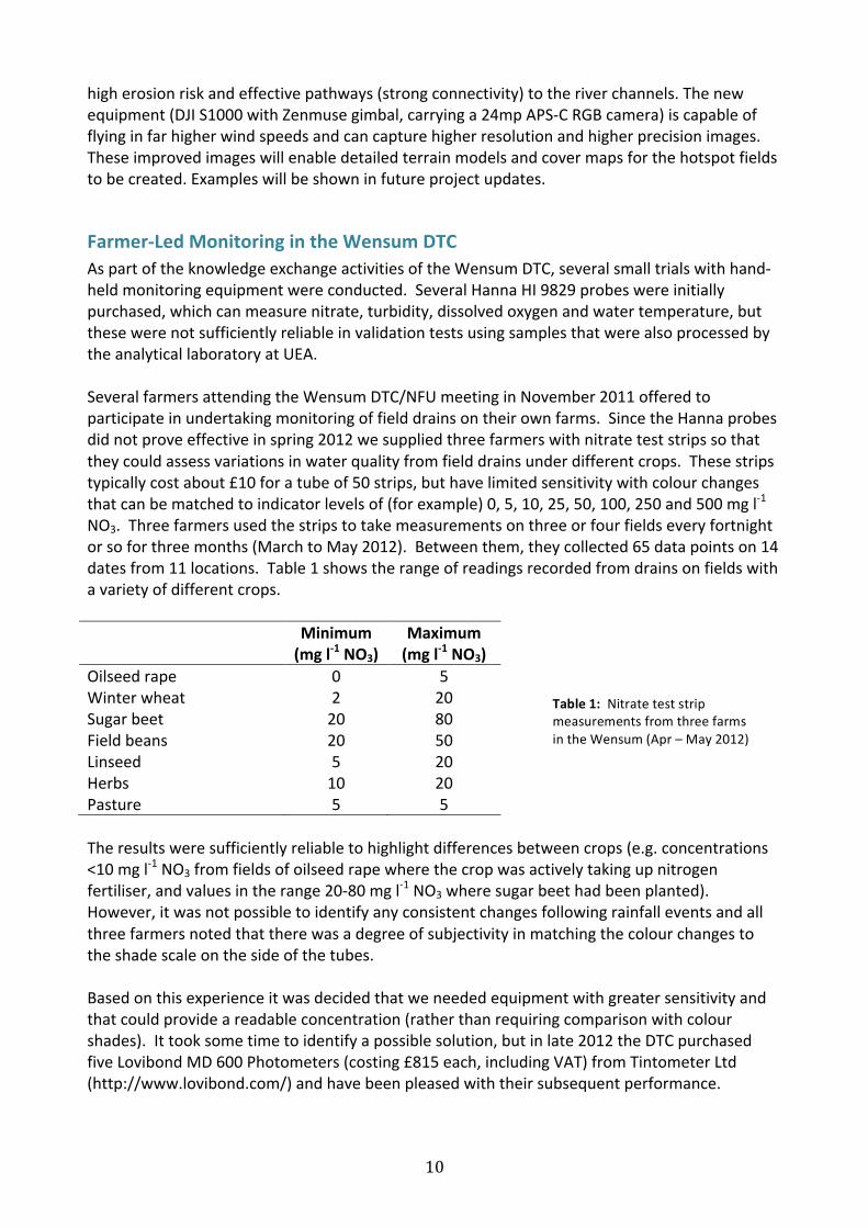
AspartoftheknowledgeexchangeactivitiesoftheWensumDTC,severalsmalltrialswithhand-heldmonitoringequipmentwereconducted.SeveralHannaHI9829probeswereinitiallypurchased,whichcanmeasurenitrate,turbidity,dissolvedoxygenandwatertemperature,butthesewerenotsufficientlyreliableinvalidationtestsusingsamplesthatwerealsoprocessedbytheanalyticallaboratoryatUEA.SeveralfarmersattendingtheWensumDTC/NFUmeetinginNovember2011offeredtoparticipateinundertakingmonitoringoffielddrainsontheirownfarms.SincetheHannaprobesdidnotproveeffectiveinspring2012wesuppliedthreefarmerswithnitrateteststripssothattheycouldassessvariationsinwaterqualityfromfielddrainsunderdifferentcrops.Thesestripstypicallycostabout£10foratubeof50strips,buthavelimitedsensitivitywithcolourchangesthatcanbematchedtoindicatorlevelsof(forexample)0,5,10,25,50,100,250and500mgl-1NO3.Threefarmersusedthestripstotakemeasurementsonthreeorfourfieldseveryfortnightorsoforthreemonths(MarchtoMay2012).Betweenthem,theycollected65datapointson14datesfrom11locations.Table1showstherangeofreadingsrecordedfromdrainsonfieldswithavarietyofdifferentcrops.
Minimum
(mgl-1NO3)
Maximum
(mgl-1NO3)
Oilseedrape 0 5Winterwheat 2 20Sugarbeet 20 80Fieldbeans 20 50Linseed 5 20Herbs 10 20Pasture 5 5Theresultsweresufficientlyreliabletohighlightdifferencesbetweencrops(e.g.concentrations<10mgl-1NO3fromfieldsofoilseedrapewherethecropwasactivelytakingupnitrogenfertiliser,andvaluesintherange20-80mgl-1NO3wheresugarbeethadbeenplanted).However,itwasnotpossibletoidentifyanyconsistentchangesfollowingrainfalleventsandallthreefarmersnotedthattherewasadegreeofsubjectivityinmatchingthecolourchangestotheshadescaleonthesideofthetubes.Basedonthisexperienceitwasdecidedthatweneededequipmentwithgreatersensitivityandthatcouldprovideareadableconcentration(ratherthanrequiringcomparisonwithcolourshades).Ittooksometimetoidentifyapossiblesolution,butinlate2012theDTCpurchasedfiveLovibondMD600Photometers(costing£815each,includingVAT)fromTintometerLtd(http://www.lovibond.com/)andhavebeenpleasedwiththeirsubsequentperformance.
Table1:NitrateteststripmeasurementsfromthreefarmsintheWensum(Apr–May2012)
11
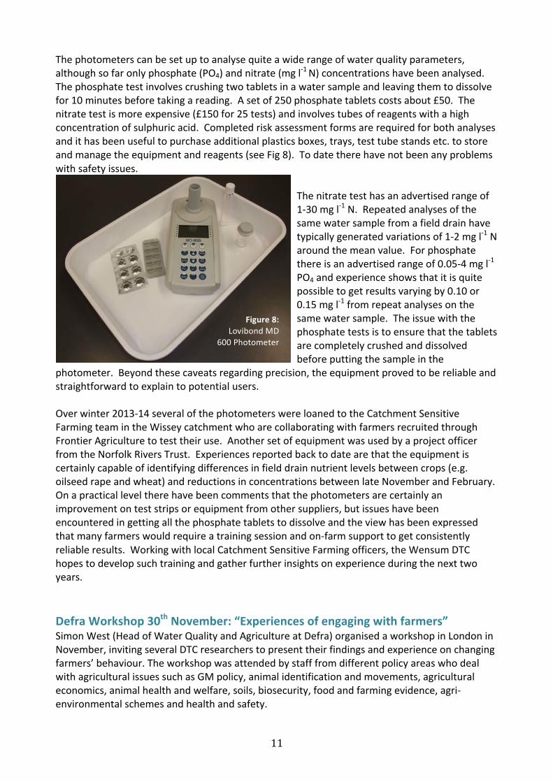
Thephotometerscanbesetuptoanalysequiteawiderangeofwaterqualityparameters,althoughsofaronlyphosphate(PO4)andnitrate(mgl-1N)concentrationshavebeenanalysed.Thephosphatetestinvolvescrushingtwotabletsinawatersampleandleavingthemtodissolvefor10minutesbeforetakingareading.Asetof250phosphatetabletscostsabout£50.Thenitratetestismoreexpensive(£150for25tests)andinvolvestubesofreagentswithahighconcentrationofsulphuricacid.Completedriskassessmentformsarerequiredforbothanalysesandithasbeenusefultopurchaseadditionalplasticsboxes,trays,testtubestandsetc.tostoreandmanagetheequipmentandreagents(seeFig8).Todatetherehavenotbeenanyproblemswithsafetyissues.
Thenitratetesthasanadvertisedrangeof1-30mgl-1N.Repeatedanalysesofthesamewatersamplefromafielddrainhavetypicallygeneratedvariationsof1-2mgl-1Naroundthemeanvalue.Forphosphatethereisanadvertisedrangeof0.05-4mgl-1PO4andexperienceshowsthatitisquitepossibletogetresultsvaryingby0.10or0.15mgl-1fromrepeatanalysesonthesamewatersample.Theissuewiththephosphatetestsistoensurethatthetabletsarecompletelycrushedanddissolvedbeforeputtingthesampleinthe
photometer.Beyondthesecaveatsregardingprecision,theequipmentprovedtobereliableandstraightforwardtoexplaintopotentialusers.Overwinter2013-14severalofthephotometerswereloanedtotheCatchmentSensitiveFarmingteamintheWisseycatchmentwhoarecollaboratingwithfarmersrecruitedthroughFrontierAgriculturetotesttheiruse.AnothersetofequipmentwasusedbyaprojectofficerfromtheNorfolkRiversTrust.Experiencesreportedbacktodatearethattheequipmentiscertainlycapableofidentifyingdifferencesinfielddrainnutrientlevelsbetweencrops(e.g.oilseedrapeandwheat)andreductionsinconcentrationsbetweenlateNovemberandFebruary.Onapracticalleveltherehavebeencommentsthatthephotometersarecertainlyanimprovementonteststripsorequipmentfromothersuppliers,butissueshavebeenencounteredingettingallthephosphatetabletstodissolveandtheviewhasbeenexpressedthatmanyfarmerswouldrequireatrainingsessionandon-farmsupporttogetconsistentlyreliableresults.WorkingwithlocalCatchmentSensitiveFarmingofficers,theWensumDTChopestodevelopsuchtrainingandgatherfurtherinsightsonexperienceduringthenexttwoyears.
DefraWorkshop30thNovember:“Experiencesofengagingwithfarmers”
SimonWest(HeadofWaterQualityandAgricultureatDefra)organisedaworkshopinLondoninNovember,invitingseveralDTCresearcherstopresenttheirfindingsandexperienceonchangingfarmers’behaviour.TheworkshopwasattendedbystafffromdifferentpolicyareaswhodealwithagriculturalissuessuchasGMpolicy,animalidentificationandmovements,agriculturaleconomics,animalhealthandwelfare,soils,biosecurity,foodandfarmingevidence,agri-environmentalschemesandhealthandsafety.
Figure8:
LovibondMD600Photometer
12
AtthebeginningoftheworkshopProf.AndrewLovettfromtheUniversityofEastAngliaintroducedthedesignandconceptoftheDTCplatform.WillCleasbyfromtheEdenDTCthendescribednumerousexamplesofstakeholderengagementachievedthroughhisworkwiththeEdenRiversTrust.PhDresearcherEmilieVrainledthemainsession,presentingherPhDresultsonfactorsinfluencingfarmeruptakeofwaterpollutionmitigationmeasuresandtheroleoffarmadvice.Theresearchfromherthesiswaspresentedto:1)provideanexemplarofexperienceandbenefitsofengagingfarmersandfarmadvisorsaboutwaterpollution,and2)highlightqualitativemethodswhichcouldbetranslatedtoaidunderstandingofhowbesttoinfluencefarmerbehaviourinothertopicareas,especiallythosewhicharehighlycontested.AlexInman,acatchmentadvisorworkingontheHampshireDTCprovidedsomereflectionsattheendofthefirstsessiontoleavetheaudiencewithfoodforthought.Informativetwo-waydialoguewasachievedthroughoutthepresentationswithallworkshopattendees.TwobreakoutgroupsconsideredhowtheDTCs’experiencemightbetransferrabletotheirpolicyanddeliveryareas.Theywerealsoaskedtocontemplatehowtheirexperiencemightbebuiltintothewaterqualityandagriculturalpolicyanddeliveryarea.Nextstepswerethendiscussedastohowdifferentpolicyareascouldworkmorecloselytogether.Oneattendeestated‘it[theworkshop]wasveryusefulforbringingtogetherpolicyareasandthereforemessages,identifying
whowecanlinkeffortswith.’Itwasagreedmoreeventsshouldbeheldinthefuturetoallowcommonsharingofknowledgebetweendepartmentswithafocusoninfluencingfarmerbehaviour.
NewUpstreamThinkingprogrammetoprotectrivers
ApartnershipofSouthWestWater(SWW),theDevonWildlifeTrust,theCornwallWildlifeTrust,theWestcountryRiversTrustandtheExmoorNationalParkAuthorityisbuildingonworkbegunin2008tochangelandmanagementpracticestoprotectriverswithanewfive-yearprogramme.SupportedbytheNationalFarmersUnion,theEnvironmentAgency,NaturalEnglandandtheFarmingandWildlifeAdvisoryGroup,theprogrammeispartofSWW'slong-termbusinessplantoreduceitsenvironmentalfootprintandmanagetheimpactof
diffusepollutiononcustomers'bills.Theprogrammehastwomainelements:adviceandgrantsforfarmersandtherestorationofpeatlandinpartnershipwithlandowners.
Thelatest£11.8millionprogrammefocuseson11catchmentsacrossDevonandCornwallin2015-20.Thetargetfortheprogrammeis750farmsand1,300haofmoorlandandothersemi-naturallandunderrevisedmanagement.UpstreamThinkingadviserswillbeworkingontheExe,theDart,theOtterandtheYeoinDevonplusgroundwatersourcesinEastDevonandthecatchmentaroundFernworthyReservoir,whileinCornwalltheywillbefocusingontheCober,theTamar,theFalmouthreservoirsandDriftreservoir.
13
Grantsaretargetedatfarmswithlandconnectedtoriversabovewaterabstractionpoints.Theaimistoreducetheamountofunwantedsubstancesinriverwater,whichinturnhelpstocontrolthecostofchemicalsandenergyneededtoturnrawwaterintohighqualitytapwater.
Grantscanhelptofundimprovementstoslurrystorage,fencingtokeeplivestockoutofrivers,providingalternativewatersourcesforlivestock,betterpesticidemanagementincludinginvestmentinnewequipment,suchasweedwiperswhichdelivertargeteddosesofherbicide.Farmersmatchthefundingandofteninvestmorebesides,aswellasbeingabletoaccessfurthersourcesoffunding.Farmerswhotookpartintheprogrammein2010-2015savedanaverageof£20,000onthingslikereducedfertilisercosts.Since2008,UpstreamThinkingadvisorshavemade1,700visitstofarmsandallocated180capitalgrantstotalling£2.2million.
ThemoorsoftheSouthWestprovideover40percentoftheregion’sdrinkingwater,andpeatlandrestorationisacrucialelementoftheUpstreamThinkingprogramme.TheExmoorMiresPartnershiphasinvestigatedandrestoredover2,000hectaresofmoorlandonExmoorandDartmoor,andplanstorestoreafurther1,000hectaresby2020.ScientificresearchcarriedoutonthemoorbytheUniversityofExeterhasshownthatrestoredbogsreleaseathirdlesswaterduringstormsand30%lessdissolvedorganiccarbon,whichdiscoloursthewater.ResearchbytheEnvironmentAgencysuggeststheworkishelpingtomaintainriverlevelsduringdriersummermonths.Contact:DrDavidSmithSWWProgrammeManager([email protected])
DTCPhase1Reportavailableshortly-someConclusions
Phase1ofDTChasreachedanumberofconclusionsconcerningthedominantsourcesineachoftheresearchcatchments,thetimingofnutrientexportfromlandtowater,andtherangeofnutrientchemistriesmobilisedandtransportedtostreamsineachofthecatchments.However,universaltruthshavenotemergedfromthisanalysisanditisclearthatcaremustbetakentoensurethatthefindingsfromoneprogrammearenotassumedtoprovideaperfectsolutioninanothercircumstancewithoutpriortestingofthosesolutionsacrossmultiplelandmanagementandgeoclimaticconditions.TheDTCmonitoringhasshownthatstormeventsarehighlyimportantindrivingthefluxofdiffusepollutionincatchmentswherethereisahighproportionofrapidrunoffinpreferentialflowpathways(surfacerunoff,near-surfacequick-flowanddrainflowindrainedlandscapesliketheWensumcatchment).However,itisthemidfloweventsthatdominatenutrientand
sedimentdeliveryincatchmentsdrivenbysubsurfacehydrologicalfunction.Similarly,nitrateisthedominantformofnitrogendeliveredtowaterbodiesinpermeablecatchments,basedontheevidencecollectedhere,butitisaminoritycomponentoftheTNloadinginlivestockfarmingsystemswherethehighstockingdensitiesandabundanceofmanureproductionleadstoenrichmentofwaterswithbothparticulateanddissolvedorganicnutrientfractionswhichwillstimulatebothalgalproductivityandmicrobialmetabolismin-stream.Amonitoringprogramme
thatfocusedsolelyonnitrateinalivestockfarmingcatchmentwouldbeunlikelytobe
sensitivetocurrentmanagementortotargetedon-farmmitigationeffortsinthecatchment.Anotherpointwhichhasemergedisthattherearesignificantuncertaintiesassociatedwithanymonitoringstrategytodetectnutrientandsedimentfluxbehavioursincatchments.Sensorsprovideon-sitehighfrequencyobservations,buttherecanbetechnologicalproblemsto
14
overcomewiththeiruse,ifrobustandreliablefindingsaretobegenerated.Simplyrelyingonthesensorswithouttestingtheaccuracyandprecisionoftheobservationswithinanuncertaintyframeworkwillconstraintheusertoimpreciseanduncertainobservations,datastreamswithsignificantgapsandalimitedrangeofdeterminandswhichmightnotbethosebestsuitedtoansweringthequestionposed.Laboratorybasedanalyseshavetheirplace,asqualitycontrolcanensurehigherqualitydata,forawiderrangeofdeterminands,albeitatalowertemporalresolution.Acombinationofmonitoringapproachesislikelytobeneededtogeneraterobust
evidencestreamsforcatchmentmitigationeffortsatanysite.InsynthesisingthesenutrientandsedimentfluxbehavioursfordifferentlandscapetypologiesacrosstheDTCplatform,carefulconsiderationalsoneedstobegiventotheappropriatestatisticaltechniquesthatareapplied(seeLloydetal.2014).Thisensurescorefindingsregardingtheefficacyofmitigationstrategiesallowforthequalityanduncertaintyofdifferentmeasurementstrategies(suchasidentifiedabove);thenaturalvariabilityintimeandspaceofcatchmentsystemsandrelatedclimaticfactors;thedurationoftheevidencebasepreandpostmitigationinlightofinherentnaturalvariabilities;andthedifferentQAproceduresandmonitoringstrategiesbetweenDTCcomponents.Finally,thecontrastbetweentheresponsesofdifferentcatchmentswithvaryingsoilsandgeologytodifferingdegreesofrainfallhasbeenshowntobecriticalindeterminingpollutantloads,andproperlyevidencingtheselectionofmitigationmeasuresinanycatchment,asistheproportionofgroundwaterthatcontributestoriverflow.Consequentlytheimportanceofidentifyingandmanagingrun-offpathwaysduringstormeventsandsubsurfacepathwaysyearroundisakeyfindingofDTC.Themannerinwhichthesebehavioursimpactontheecosystemfunctionandhealthofthereceivingwaterbodiesarediscussedfurtherinthefullreport.
SoilmoisturemonitoringintheWensumDTC
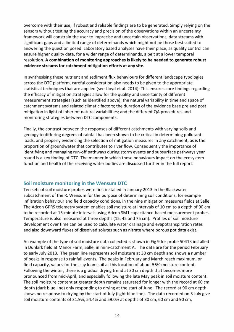
TensetsofsoilmoistureprobeswerefirstinstalledinJanuary2013intheBlackwatersubcatchmentoftheR.Wensumforthepurposeofdeterminingsoilconditions,forexampleinfiltrationbehaviourandfieldcapacityconditions,intheninemitigationmeasuresfieldsatSalle.TheAdconGPRStelemetrysystemenablessoilmoistureatintervalsof10cmtoadepthof90cmtoberecordedat15-minuteintervalsusingAdconSM1capacitance-basedmeasurementprobes.Temperatureisalsomeasuredatthreedepths(15,45and75cm).Profilesofsoilmoisturedevelopmentovertimecanbeusedtocalculatewaterdrainageandevapotranspirationratesandalsodownwardfluxesofdissolvedsolutessuchasnitratewhereporouspotdataexist.AnexampleofthetypeofsoilmoisturedatacollectedisshowninFig9forprobe50413installedinDunkirkfieldatManorFarm,Salle,inmini-catchmentA.ThedataarefortheperiodFebruarytoearlyJuly2013.Thegreenlinerepresentssoilmoistureat30cmdepthandshowsanumberofpeaksinresponsetorainfallevents.ThepeaksinFebruaryandMarchreachmaximum,orfieldcapacity,valuesfortheclayloamsoilatthislocationofabout56%moisturecontent.Followingthewinter,thereisagradualdryingtrendat30cmdepththatbecomesmorepronouncedfrommid-April,andespeciallyfollowingthelateMaypeakinsoilmoisturecontent.Thesoilmoisturecontentatgreaterdepthremainssaturatedforlongerwiththerecordat60cmdepth(darkblueline)onlyrespondingtodryingatthestartofJune.Therecordat90cmdepthshowsnoresponsetodryingbythestartofJuly(lightblueline).Thedatarecordedon3Julygivesoilmoisturecontentsof31.9%,54.4%and59.0%atdepthsof30cm,60cmand90cm,
15
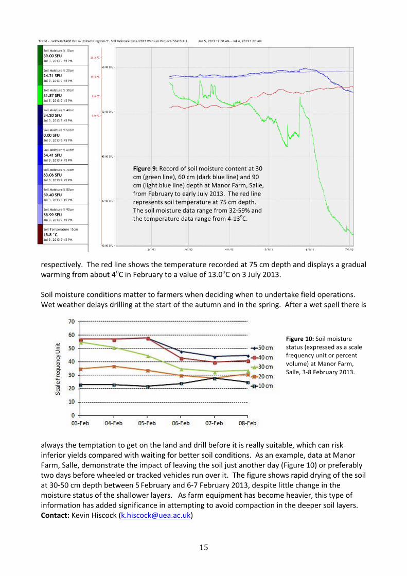
respectively.Theredlineshowsthetemperaturerecordedat75cmdepthanddisplaysagradualwarmingfromabout4oCinFebruarytoavalueof13.0oCon3July2013.Soilmoistureconditionsmattertofarmerswhendecidingwhentoundertakefieldoperations.Wetweatherdelaysdrillingatthestartoftheautumnandinthespring.Afterawetspellthereis
alwaysthetemptationtogetonthelandanddrillbeforeitisreallysuitable,whichcanriskinferioryieldscomparedwithwaitingforbettersoilconditions.Asanexample,dataatManorFarm,Salle,demonstratetheimpactofleavingthesoiljustanotherday(Figure10)orpreferablytwodaysbeforewheeledortrackedvehiclesrunoverit.Thefigureshowsrapiddryingofthesoilat30-50cmdepthbetween5Februaryand6-7February2013,despitelittlechangeinthemoisturestatusoftheshallowerlayers.Asfarmequipmenthasbecomeheavier,thistypeofinformationhasaddedsignificanceinattemptingtoavoidcompactioninthedeepersoillayers.Contact:KevinHiscock([email protected])
Figure10:Soilmoisturestatus(expressedasascalefrequencyunitorpercentvolume)atManorFarm,Salle,3-8February2013.
Figure9:Recordofsoilmoisturecontentat30cm(greenline),60cm(darkblueline)and90cm(lightblueline)depthatManorFarm,Salle,fromFebruarytoearlyJuly2013.Theredlinerepresentssoiltemperatureat75cmdepth.Thesoilmoisturedatarangefrom32-59%andthetemperaturedatarangefrom4-13oC.
16
LastPost–fromBobHarrisThisisthelastDTCnewsletterthatIshallbeputtingtogether,thetaskpassingtotheWensumDTCConsortiumfor2016(contact:AndrewLovett).I’vereallyenjoyedmy6+yearsworkingwithDefra,theDTCConsortiaandthewiderrelatedresearchandstakeholdergroups.Theearlydayswereexcitingwiththeemergenceofnewpoliticalwilltodevelop‘catchmentthinking’andaddressthechallengesofmoreintegratedorholisticapproachestoscientificresearchandenvironmentalmanagement.However,thesupportedconceptofalong-termresearchplatformtobuildknowledgeandtestpracticalmeasuresinarobustscientificwaywasalwaysgoingtobechallenging,andsoit’sturnedout,compoundednowbytheserecenttimesofeconomicconstraint.Unfortunatelyaswelearnmoreaboutthecomplexitiesofundertakingresearchatthecatchmentscale(especiallythechallengesofscalingupfromplot,fieldandfarmwheretheexperimentsinevitablyhavetobeundertaken,towholecatchmentsandlandscapes)themorewerealisethattheanswerstobothpolicyandoperationalquestionscannotbeansweredquickly.StormDesmondhasalsorecentlydemonstratedthatthelonger-andshorter-termclimaticchanges,betheyinduced(climatechangerelated)ornatural(ElNinoandNAtlanticOscillationrelated),maywellswamptherelativelysmallwaterqualitychangesinourriversandgroundwaterthatfarm-scalemeasurescanbring.So,manyuncertaintiesremainnottheleastthefeelingthatsmall-scaleon-farmmeasureswillbeinsufficienttoaddressthechallengesfacingwaterqualityandthesubsequentstressesonfreshwaterecosystems–wemaynotbeable‘tohaveourcakeandeatittoo’throughacontinuationofwithamodifiedbusiness-as-usualapproach.Largerlandusechangemaybenecessarytohaltthedeclineinourfreshwaterbiodiversity…Ifthisisapriorityofsociety.Whatevertheapproachandthesolutionsweneedtohavetheresearchcapabilitytoinvestigatethequestionsposedwhetherbypolicy-makers,catchment-managersorlandmanagers.Withoutknowledge,andtheabilitytouseitintelligentlyinmoreintegratedways,wewillcontinuetofumbleinthedark!
And a Happy New Year to all