Embed Size (px)
Citation preview
1
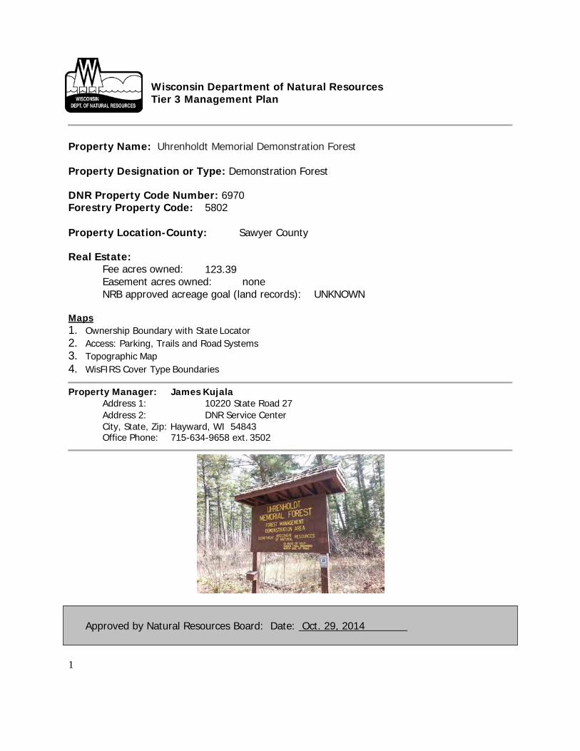
Wisconsin Department of Natural Resources Tier 3 Management Plan
Property Name: Uhrenholdt Memorial Demonstration Forest
Approved by Natural Resources Board: Date: Oct. 29, 2014
Property Designation or Type: Demonstration Forest DNR Property Code Number: 6970 Forestry Property Code: 5802
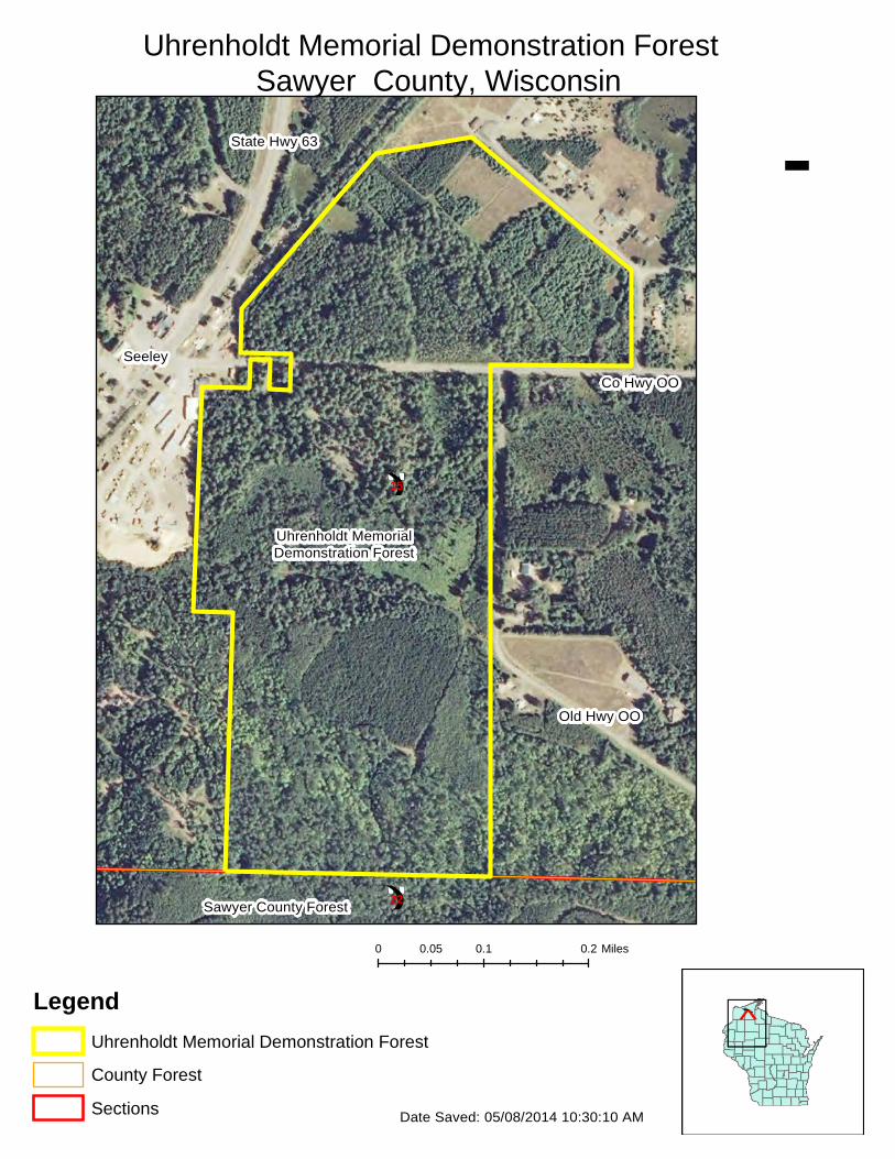
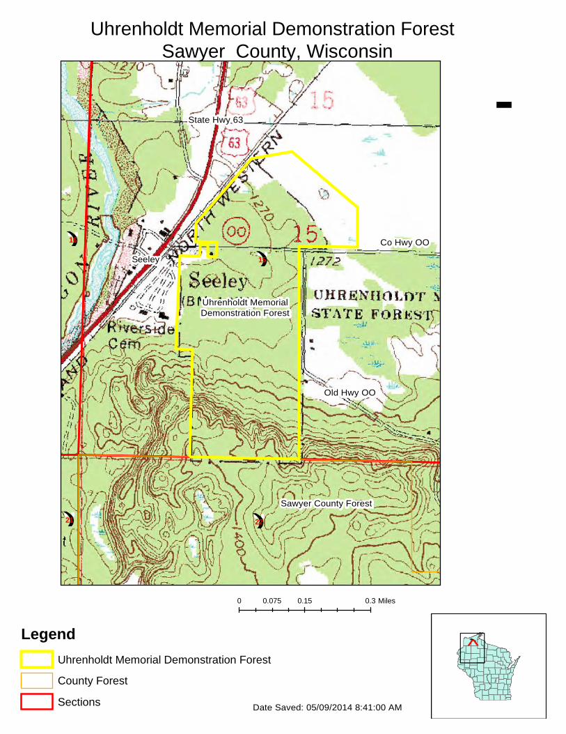
Property Location-County: Sawyer County
Real Estate: Fee acres owned: 123.39 Easement acres owned: none NRB approved acreage goal (land records): UNKNOWN
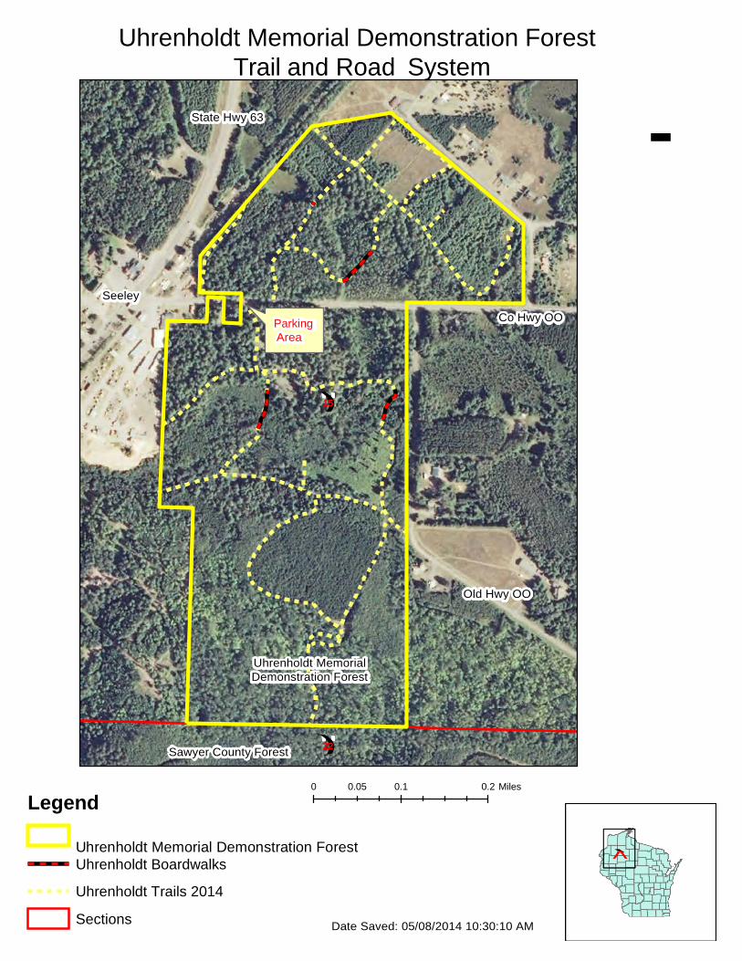
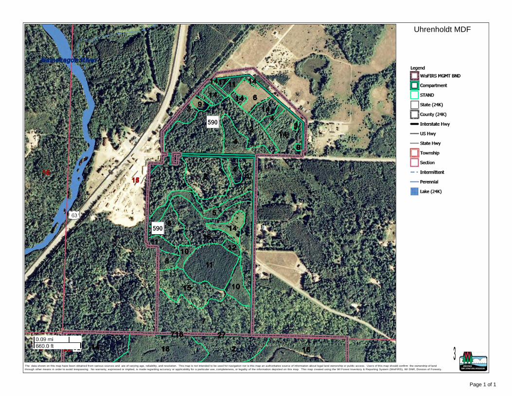
Maps 1. Ownership Boundary with State Locator 2. Access: Parking, Trails and Road Systems 3. Topographic Map 4. WisFIRS Cover Type Boundaries
Property Manager: James Kujala Address 1: 10220 State Road 27 Address 2: DNR Service Center City, State, Zip: Hayward, WI 54843 Office Phone: 715-634-9658 ext. 3502
2
A. Regional and Property Assessment
1. Landscape and Regional Context The Uhrenholdt Memorial Demonstration Forest is located primarily within the Northwest Sands Ecological Landscape, although the southern portion of the property crosses into the North Central Forest. The property is within the Upper Namekagon River watershed. The local landscape is almost entirely forested, with relatively minor amounts of agriculture present, including a nearby cranberry operation to the north.
2. Ownership and Adjacent Land Uses
The Uhrenholdt Memorial Demonstration Forest is located near Seeley, Wisconsin in Sawyer County, less than 1/8 mile from U.S. Highway 63. County Highway OO bisects the Uhrenholdt Forest, and a town road, Old Highway OO, borders the forest on a portion of its’ southeastern side. A town road, Valley Road, borders the property on its northeastern side.
Adjacent ownership includes the Sawyer County Forest (Seeley Hills Block) on the south boundary, and many small privately owned parcels (developed and undeveloped) surrounding the rest of the property, including the Vortanz Sawmill on the western boundary. Although it is not immediately adjacent, the Namekagon River, part of the St. Croix National Scenic Riverway, is less than ¼ mile away to the west.
3. General Property Description and Management History and Use
Located in the Namekagon River valley, much of the Uhrenholdt Memorial Demonstration Forest is dominated by flat topography with sandy and sandy loam soils, primarily supporting red and white pine, and aspen forest types. The south end of the property includes land that rises in elevation and climbs to the Seeley Hills, and this part of the property includes a red oak forest type with slightly more fertile soils. There are wetland areas within the Uhrenholdt, comprised of tamarack and black spruce timber types, as well as non-forested tag alder and lowland grass types. There are not any navigable streams, lakes, or ponds located on the property.
DNR records indicate that the Uhrenholdt Memorial Demonstration Forest was acquired by the State of Wisconsin in several steps beginning in 1947 with a purchase of 104 acres from Jens Uhrenholdt, a local farmer, logger, and son of Soren and Kristine. Jens Uhrenholdt sold an additional 3.5 acres to the state in 1969. In 1974 two additional purchases were made from William Flavell and Edward Cody totaling approximately 15 acres, completing the current ownership and boundaries of the Uhrenholdt Forest.
Soren and Kristine Uhrenholdt established a family farm in the Namekagon River valley in 1900. As with many farmers, logging and caring for the land played a large role in the family’s survival. After World War II, the children of Soren and Kristine desired to create a
3
memorial forest as a sanctuary for the memory of their parents, as well as for son Andrew and grandson Curtis, who were lost in World Wars I and II respectively. In 1947 a large memorial stone was engraved with an inscription in memory of these 4 family members, and placed in the forest by the Wisconsin Conservation Department on the north side of Highway OO.
Records indicate the old growth stand of white pine located north of Highway OO where the memorial stone was placed has been unmanaged or passively managed, with the primary objective of leaving this area as a “memorial sanctuary” to Soren, Kristine, Andrew, and Curtis. This unmanaged white pine stand has also been used as an educational comparison to the managed part of the Demonstration Forest located south of the highway, and those managed areas on the north side of the highway surrounding the old growth stand. The portion of the property located south of Highway OO has a long history of active forest management, with the purpose of demonstrating sustainable forest management techniques.
4. Land Management Cover Types
• See attachments from WisFIRS.
5. Endangered, Threatened, Special Concern Species or Habitats, and Wildlife Species of Greatest Conservation Need
The NHI database lists Northern Wet Forest and Northern Mesic Forest as occurring on the Uhrenholdt Demonstration Forest. The NHI database does not list any wildlife or plant species as occurring on the property, but comprehensive surveys have not taken place.
6. Invasive Species
An invasive species survey has not been completed for the property. A survey is planned to be completed in the summer of 2014.
7. Cultural and Archaeological Features
A search of the state database for cultural and archeological features indicates that a burial site is located within the Uhrenholdt Memorial Demonstration Forest. This area must be protected against any unauthorized disturbance by WI stats 157.70.
Within the defined burial site area:
• Any ground disturbing activities such as stump pulling and road construction will be
prohibited. • Harvesting should be restricted to be done only on well-frozen ground, ideally with snow
cover, to minimize soil disturbance. • All other vehicle use within burial site area will be prohibited year round.

4
8. Public Uses and Infrastructure
• A small parking area is located on the south side of Highway OO. There is a sign located at the parking area.
• Recreational users include walkers, hikers, runners, bikers, cross country skiers, hunters and snowmobilers.
• The Seeley Lions Club hosts an annual children’s fat tire bike event that utilizes a portion of the trail system.
• A short stretch of snowmobile trail crosses the property on the north side of Hwy OO on its’ western edge. Sawyer County currently has an approved DNR Snowmobile Use Permit to use and manage this very short section of trail in the winter.
• A simple weather resistant pamphlet holder contains a map and information about the educational foot/walking path and the stands of timber along the path. The walking paths include several wooden walkways that pass through wetlands. These wooden walkways were built in the 1970s and 1980s.
• Service roads, which are better described as “woods roads”, are present and open for foot and bike travel, as well as cross country skiing, but are normally gated and closed to motorized travel except when needed for working staff and contractors, or for special public events.
• A gated forest road allows access to a block of the Sawyer County Forest to the south, but the hill leading from the Demonstration Forest to the County Forest is so steep it is not practical to use it for timber hauling purposes.
9. Refuges and other Closed Areas There are not any areas on the property that are closed to the public. Access roads within the property are normally gated and closed to vehicle access. These access roads are occasionally opened for organized public recreation events or for work access by staff or contractors.
10. Administrative Facilities
• There are not any administrative facilities located on the property. Significant Property Management Issues, Trends and Needs:
Robert Olson, son of famous writer and outdoorsman Sigurd Olson and his wife Elizabeth Olson, and grandson of Soren and Kristine Uhrenholdt, currently lives on the original Uhrenholdt homestead that is adjacent to the Uhrenholdt Demonstration Memorial Forest. Mr. Olson has been actively involved in the development of this plan by providing a history of the property and his family’s ideas for future management. His comments have primarily focused on the past and future management of the area of the property located north of Highway OO.
In the area of the Demonstration Forest north of Highway OO, Mr. Olson has requested the area be managed primarily as a “Memorial”, or area of “sanctuary”, as was originally proposed and practiced since 1947. He did state that his extended family’s current wishes for
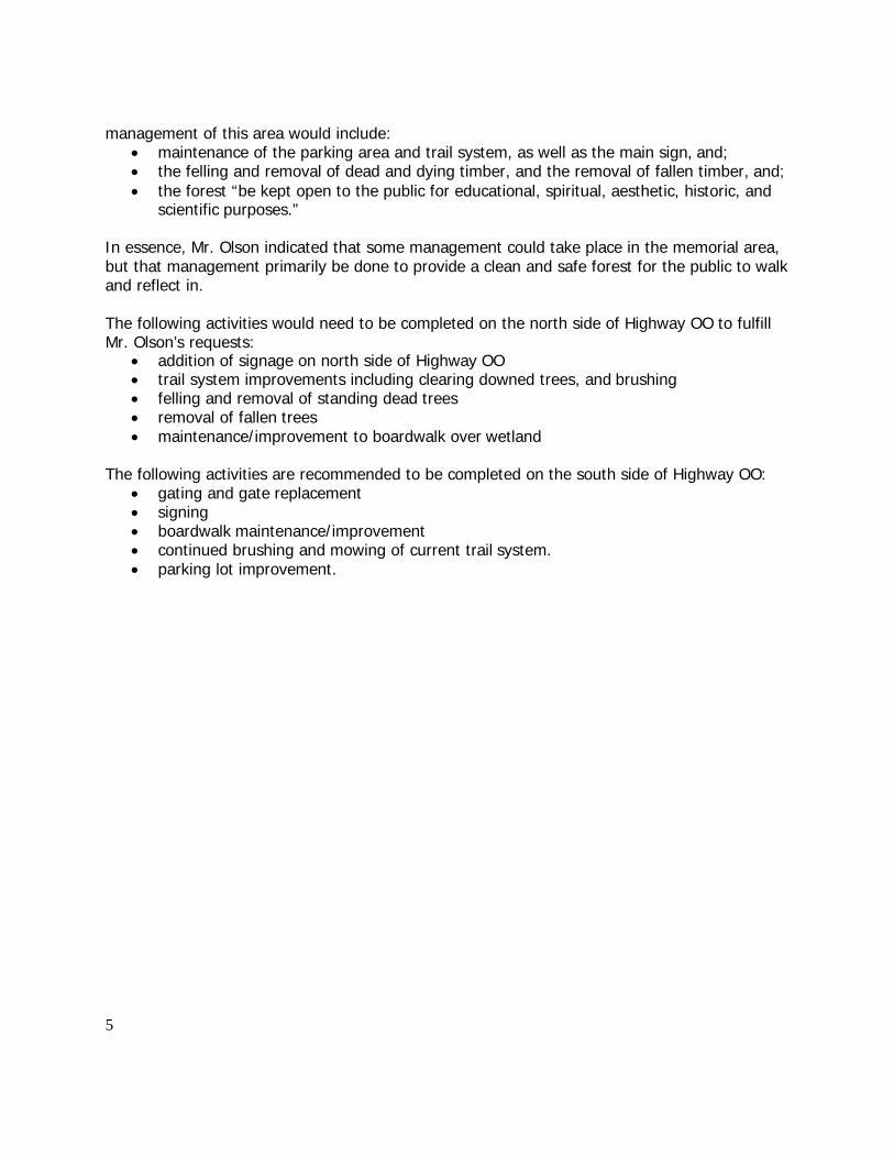
5
management of this area would include: • maintenance of the parking area and trail system, as well as the main sign, and; • the felling and removal of dead and dying timber, and the removal of fallen timber, and; • the forest “be kept open to the public for educational, spiritual, aesthetic, historic, and
scientific purposes.” In essence, Mr. Olson indicated that some management could take place in the memorial area, but that management primarily be done to provide a clean and safe forest for the public to walk and reflect in.
The following activities would need to be completed on the north side of Highway OO to fulfill Mr. Olson’s requests:
• addition of signage on north side of Highway OO • trail system improvements including clearing downed trees, and brushing • felling and removal of standing dead trees • removal of fallen trees • maintenance/improvement to boardwalk over wetland
The following activities are recommended to be completed on the south side of Highway OO:
• gating and gate replacement • signing • boardwalk maintenance/improvement • continued brushing and mowing of current trail system. • parking lot improvement.
6
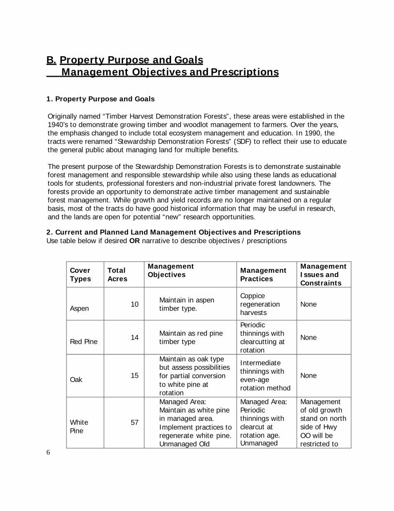
B. Property Purpose and Goals Management Objectives and Prescriptions
1. Property Purpose and Goals
Originally named “Timber Harvest Demonstration Forests”, these areas were established in the 1940’s to demonstrate growing timber and woodlot management to farmers. Over the years, the emphasis changed to include total ecosystem management and education. In 1990, the tracts were renamed “Stewardship Demonstration Forests” (SDF) to reflect their use to educate the general public about managing land for multiple benefits.
The present purpose of the Stewardship Demonstration Forests is to demonstrate sustainable forest management and responsible stewardship while also using these lands as educational tools for students, professional foresters and non-industrial private forest landowners. The forests provide an opportunity to demonstrate active timber management and sustainable forest management. While growth and yield records are no longer maintained on a regular basis, most of the tracts do have good historical information that may be useful in research, and the lands are open for potential “new” research opportunities.
2. Current and Planned Land Management Objectives and Prescriptions Use table below if desired OR narrative to describe objectives / prescriptions
Cover Types
Total Acres
Management Objectives Management
Practices
Management Issues and Constraints
Aspen
10
Maintain in aspen timber type.
Coppice regeneration harvests
None
Red Pine
14
Maintain as red pine timber type
Periodic thinnings with clearcutting at rotation
None
Oak
15
Maintain as oak type but assess possibilities for partial conversion to white pine at rotation
Intermediate thinnings with even-age rotation method
None
White Pine
57
Managed Area: Maintain as white pine in managed area. Implement practices to regenerate white pine. Unmanaged Old
Managed Area: Periodic thinnings with clearcut at rotation age. Unmanaged
Management of old growth stand on north side of Hwy OO will be restricted to
7
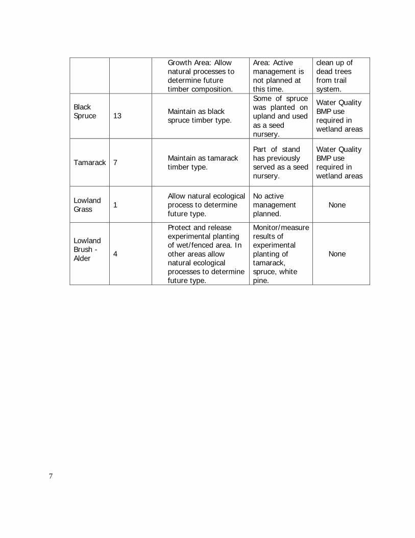
Growth Area: Allow
natural processes to determine future timber composition.
Area: Active management is not planned at this time.
clean up of dead trees from trail system.
Black Spruce
13
Maintain as black spruce timber type.
Some of spruce was planted on upland and used as a seed nursery.
Water Quality BMP use required in wetland areas
Tamarack
7
Maintain as tamarack timber type.
Part of stand has previously served as a seed nursery.
Water Quality BMP use required in wetland areas
Lowland Grass
1
Allow natural ecological process to determine future type.
No active management planned.
None
Lowland Brush - Alder
4
Protect and release experimental planting of wet/fenced area. In other areas allow natural ecological processes to determine future type.
Monitor/measure results of experimental planting of tamarack, spruce, white pine.
None
8
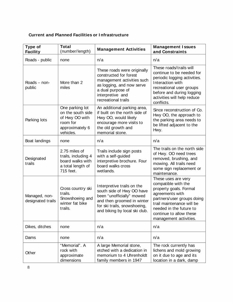
Current and Planned Facilities or Infrastructure
Type of Facility
Total (number/length) Management Activities Management Issues
and Constraints
Roads - public none n/a n/a
Roads – non- public
More than 2 miles
These roads were originally constructed for forest management activities such as logging, and now serve a dual purpose of interpretive and recreational trails
These roads/trails will continue to be needed for periodic logging activities. Interaction with recreational user groups before and during logging activities will help reduce conflicts.
Parking lots
One parking lot on the south side of Hwy OO with room for approximately 6 vehicles.
An additional parking area, if built on the north side of Hwy OO, would likely encourage more visits to the old growth and memorial stone.
Since reconstruction of Co. Hwy OO, the approach to the parking area needs to be lifted adjacent to the Hwy.
Boat landings none n/a n/a
Designated trails
2.75 miles of trails, including 4 board walks with a total length of 715 feet.
Trails include sign posts with a self-guided interpretive brochure. Four board walks cross wetlands.
The trails on the north side of Hwy. OO need trees removed, brushing, and mowing. All trails need some sign replacement or maintenance.
Managed, non- designated trails
Cross country ski trails. Snowshoeing and winter fat bike trails.
Interpretive trails on the south side of Hwy OO have been “unofficially” mowed and then groomed in winter for ski trails, snowshoeing, and biking by local ski club.
These uses are very compatible with the property goals. Formal agreements with partners/user groups doing trail maintenance will be needed in the future to continue to allow these management activities.
Dikes, ditches none n/a n/a
Dams none n/a n/a
Other
“Memorial”. A rock with approximate dimensions
A large Memorial stone, etched with a dedication in memorium to 4 Uhrenholdt family members in 1947
The rock currently has lichens and mold growing on it due to age and its location in a dark, damp
9
4’x3’x3’ and placed adjacent to the
trail system on the north side of Hwy OO.
forest understory. Also, it is located just far enough off the highway that it is not readily apparent to visitors that it is there. A sign indicating its presence and a cleaning of the stone’s surface is recommended.
Other On-going Management Activities (add additional items as necessary)
Current Management Actions Management Issues and
Constraints Project Boundary Modification
None None
Invasive exotic species None known. Survey planned for summer 2014.
None at this time.
Endangered, Threatened, Special Concern Species or Habitats, and Wildlife Species of Greatest Conservation Need
Search of Natural Heritage Inventory database shows 2 forest communities, a special concern mussel, and a threatened reptile within the 1 mile buffer area.
None of these NHI hits are known to exist or have suitable habitat within the Uhrenholdt Forest.
Cultural and Archeological Resources
Archeological records indicate a burial site may be located on the south and west side of the property.
Future ground disturbing activities prohibited in the designated area.
10
SUMMARY OF PUBLIC INVOLVEMENT ACTIVITIES FOR THIS PLAN AND COMMENTS RECEIVED
Gordon Christians, Retired DNR Forester and assigned Uhrenholdt property manager for more than 30 years. (1980-2012)
Robert Olson, local resident, grandson of original owners and homesteaders Soren and Kristine Uhrenholdt
Terry Penman, volunteer and Seeley Lions Club member
On May 20, 2014, a 21-day public review period for revision of Stewardship Demonstration Forest property management plans was publicly noticed statewide. Publics and partners were informed by way of a statewide press release and an email distribution to subscribers of ‘eGov’, a statewide government delivery system.
A comprehensive DNR web page was developed for Stewardship Demonstration Forests to describe their history and purpose, and to identify individual properties and locations. Draft management plans were posted on the website for public viewing.
The public was invited to respond by on-line electronic comment form, paper comment forms and email. Consultation occurred for Stewardship Demonstration Forests located within the tribal ceded territory.
No comments were received by the public.
Legend Uhrenholdt Memorial Demonstration Forest
County Forest
`̂
Sections Date Saved: 05/08/2014 10:30:10 AM
State Hwy 63
Seeley
Co Hwy OO
")15
Uhrenholdt Memorial Demonstration Forest
Old Hwy OO
Sawyer County Forest ")22
Uhrenholdt Memorial Demonstration Forest Sawyer County, Wisconsin
.
0 0.05 0.1 0.2 Miles
Legend Uhrenholdt Memorial Demonstration Forest
County Forest
`̂
Sections Date Saved: 05/09/2014 8:41:00 AM
State Hwy 63
")16 Co Hwy OO
Seeley ")15
Uhrenholdt Memorial Demonstration Forest
Old Hwy OO
")21
Sawyer County Forest
")22
Uhrenholdt Memorial Demonstration Forest Sawyer County, Wisconsin
.
0 0.075 0.15 0.3 Miles
Sections Date Saved: 05/08/2014 10:30:10 AM
State Hwy 63
Seeley
Parking Area
Co Hwy OO
")15
Old Hwy OO
Uhrenholdt Memorial Demonstration Forest
Sawyer County Forest ")22
Uhrenholdt Memorial Demonstration Forest Trail and Road System
.
Legend 0 0.05 0.1 0.2 Miles
Uhrenholdt Memorial Demonstration Forest `̂ Uhrenholdt Boardwalks
Uhrenholdt Trails 2014
Uhrenholdt MDF
The data shown on this map have been obtained from various sources and are of varying age, reliability, and resolution. This map is not intended to be used for navigation nor is this map an authoritative source of information about legal land ownership or public access. Users of this map should confirm the ownership of land through other means in order to avoid trespassing. No warranty, expressed or implied, is made regarding accuracy or applicability for a particular use, completeness, or legality of the information depicted on this map. This map created using the WI Forest Inventory & Reporting System (WisFIRS), WI DNR, Division of Forestry.
Page 1 of 1
³
Wisconsin Department of Natural Resources Division of Forestry dnr.wi.gov Page 1 of 3
5802 - UHRENHOLDT MEM TIMBER DEMO FOREST
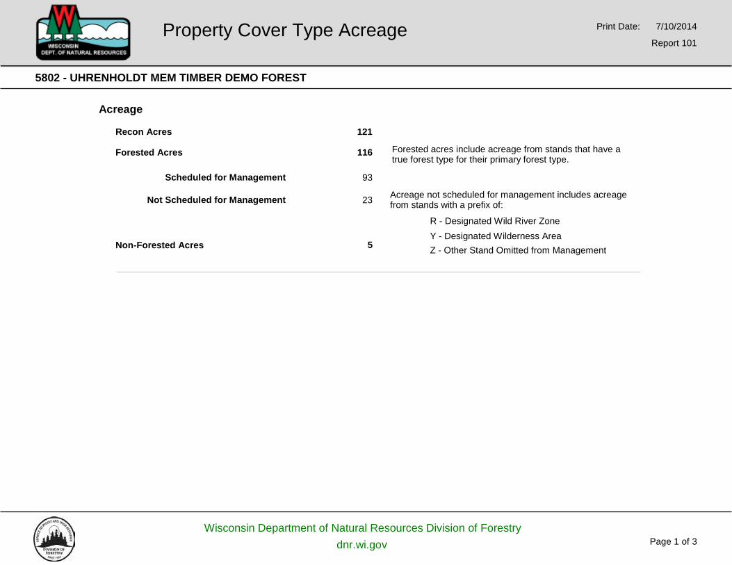
Acreage
Recon Acres 121
Forested Acres
Scheduled for Management
Not Scheduled for Management
Non-Forested Acres
116
93
23
5
Forested acres include acreage from stands that have a true forest type for their primary forest type.
Acreage not scheduled for management includes acreage from stands with a prefix of:
R - Designated Wild River Zone Y - Designated Wilderness Area Z - Other Stand Omitted from Management
Property Cover Type Acreage Print Date: 7/10/2014
Report 101
Wisconsin Department of Natural Resources Division of Forestry dnr.wi.gov Page 2 of 3
5802 - UHRENHOLDT MEM TIMBER DEMO FOREST
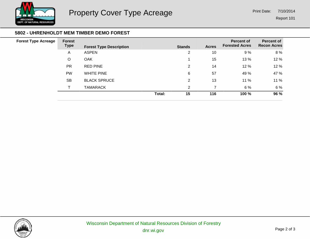
Forest Type Acreage Forest Type
Forest Type Description
Stands
Percent of Acres Forested Acres
Percent of Recon Acres
A ASPEN 2 10 9 % 8 % O OAK 1 15 13 % 12 % PR RED PINE 2 14 12 % 12 % PW WHITE PINE 6 57 49 % 47 % SB BLACK SPRUCE 2 13 11 % 11 % T TAMARACK 2 7 6 % 6 % Total: 15 116 100 % 96 %
Property Cover Type Acreage Print Date: 7/10/2014
Report 101
Wisconsin Department of Natural Resources Division of Forestry dnr.wi.gov Page 3 of 3
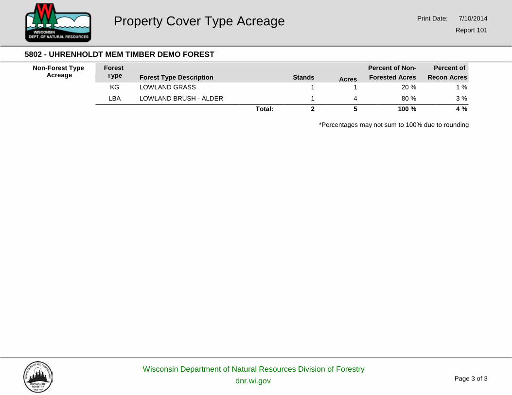
5802 - UHRENHOLDT MEM TIMBER DEMO FOREST Non-Forest Type
Acreage Forest Percent of Non- Percent of
*Percentages may not sum to 100% due to rounding
Property Cover Type Acreage Print Date: 7/10/2014
Report 101
Type Forest Type Description Stands Acres Forested Acres Recon Acres KG LOWLAND GRASS 1 1 20 % 1 %
LBA LOWLAND BRUSH - ALDER 1 4 80 % 3 % Total: 2 5 100 % 4 %
Wisconsin Department of Natural Resources Division of Forestry dnr.wi.gov Page 1 of 2
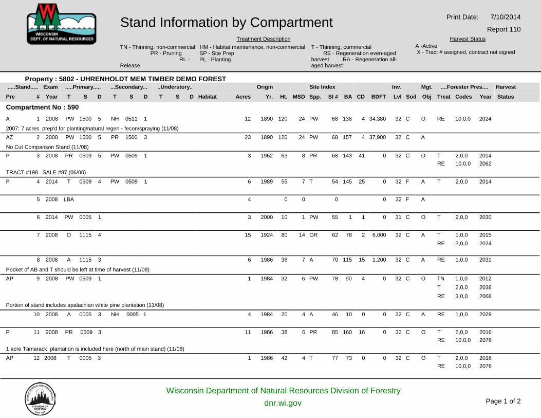
.....Stand..... Exam .....Primary..... ...Secondary... ..Understory.. Origin Site Index Inv. Mgt. ....Forester Pres.... Harvest
Pre # Year T S D T S D T S D Habitat Acres Yr. Ht. MSD Spp. SI # BA CD BDFT Lvl Soil Obj Treat Codes Year Status
Property : 5802 - UHRENHOLDT MEM TIMBER DEMO FOREST
Compartment No : 590 A 1 2008 PW 1500 5 NH 0511 1 12 1890 120 24 PW 68 138 4 34,380 32 C O RE 10,0,0 2024
2007: 7 acres prep'd for planting/natural regen - fecon/spraying (11/08) AZ 2 2008 PW 1500 5 PR 1500 3 23 1890 120 24 PW 68 157 4 37,900 32 C A
No Cut Comparison Stand (11/08) P 3 2008 PR 0509 5 PW 0509 1 3 1962 63 8 PR 68 143 41 0 32 C O T 2,0,0 2014
RE 10,0,0 2062 TRACT #198 SALE #87 (06/00)
P 4 2014 T 0509 4 PW 0509 1 6 1989 55 7 T 54 145 25 0 32 F A T 2,0,0 2014
5 2008 LBA 4 0 0 0 0 32 F A
6 2014 PW 0005 1 3 2000 10 1 PW 55 1 1 0 31 C O T 2,0,0 2030
7 2008 O 1115 4 15 1924 80 14 OR 62 78 2 6,000 32 C A T 1,0,0 2015 RE 3,0,0 2024
8 2008 A 1115 3 6 1986 36 7 A 70 115 15 1,200 32 C A RE 1,0,0 2031
Pocket of AB and T should be left at time of harvest (11/08) AP 9 2008 PW 0509 1 1 1984 32 6 PW 78 90 4 0 32 C O TN 1,0,0 2012
T 2,0,0 2038 RE 3,0,0 2068
Portion of stand includes apalachian white pine plantation (11/08) 10 2008 A 0005 3 NH 0005 1 4 1984 20 4 A 46 10 0 0 32 C A RE 1,0,0 2029
P 11 2008 PR 0509 3 11 1986 38 6 PR 85 160 16 0 32 C O T 2,0,0 2016 RE 10,0,0 2076
1 acre Tamarack plantation is included here (north of main stand) (11/08) AP 12 2008 T 0005 3 1 1986 42 4 T 77 73 0 0 32 C O T 2,0,0 2016
RE 10,0,0 2076
Stand Information by Compartment Treatment Description
Print Date: 7/10/2014
Report 110 Harvest Status
TN - Thinning, non-commercial HM - Habitat maintenance, non-commercial PR - Pruning
RL - SP - Site Prep PL - Planting
T - Thinning, commercial RE - Regeneration even-aged
A -Active X - Tract # assigned, contract not signed
harvest RA - Regeneration all- Release aged harvest
Wisconsin Department of Natural Resources Division of Forestry dnr.wi.gov Page 2 of 2
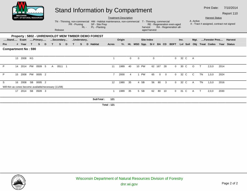
.....Stand..... Exam .....Primary..... ...Secondary... ..Understory.. Origin Site Index Inv. Mgt. ....Forester Pres.... Harvest
Pre # Year T S D T S D T S D Habitat Acres Yr. Ht. MSD Spp. SI # BA CD BDFT Lvl Soil Obj Treat Codes Year Status
Property : 5802 - UHRENHOLDT MEM TIMBER DEMO FOREST
Compartment No : 590 13 2008 KG 1 0 0 0 0 32 C A
P 14 2014 PW 0509 5 A 0511 1 11 1989 40 10 PW 62 167 28 0 30 C O T 2,0,0 2014
P 15 2008 PW 0005 2 7 2000 4 1 PW 65 0 0 0 32 C C TN 1,0,0 2024
S 16 2008 SB 0005 2 12 1980 35 4 SB 56 80 3 0 32 C A TN 1,0,0 2016
Will thin as cones become available/necessary (11/08) 17 2014 SB 0509 3 1 1989 35 5 SB 62 80 10 0 31 C A T 2,0,0 2030
SubTotal : 121
Total : 121
Stand Information by Compartment Treatment Description
Print Date: 7/10/2014
Report 110 Harvest Status
TN - Thinning, non-commercial HM - Habitat maintenance, non-commercial PR - Pruning
RL - SP - Site Prep PL - Planting
T - Thinning, commercial RE - Regeneration even-aged
A -Active X - Tract # assigned, contract not signed
harvest RA - Regeneration all- Release aged harvest
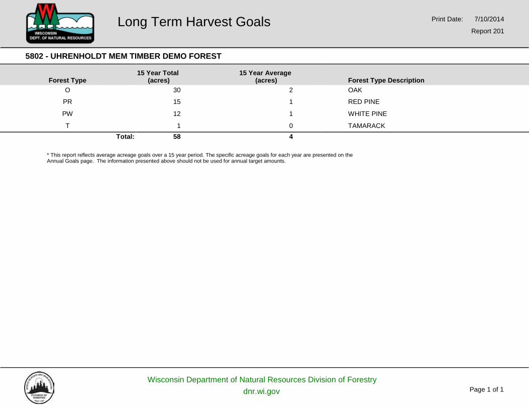
5802 - UHRENHOLDT MEM TIMBER DEMO FOREST
Forest Type
15 Year Total
(acres) 15 Year Average
(acres)
Forest Type Description O 30 2 OAK
PR 15 1 RED PINE
PW 12 1 WHITE PINE
T 1 0 TAMARACK Total: 58 4
* This report reflects average acreage goals over a 15 year period. The specific acreage goals for each year are presented on the Annual Goals page. The information presented above should not be used for annual target amounts.
Wisconsin Department of Natural Resources Division of Forestry dnr.wi.gov Page 1 of 1
Long Term Harvest Goals Print Date: 7/10/2014
Report 201