Embed Size (px)
Citation preview
River management in Japan -With focus on river levee-
January 2009Masahiro Atsumi
River Bureau, Ministry of Land, Infrastructure, Transport and Tourism, Japan
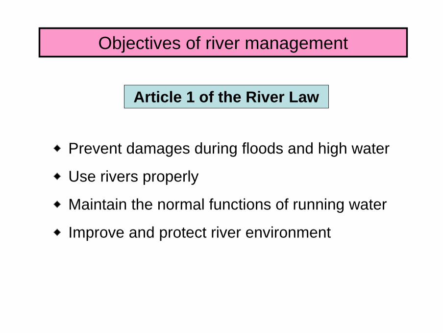
Objectives of river management
◆Prevent damages during floods and high water
◆Use rivers properly
◆Maintain the normal functions of running water
◆Improve and protect river environment
Article 1 of the River Law
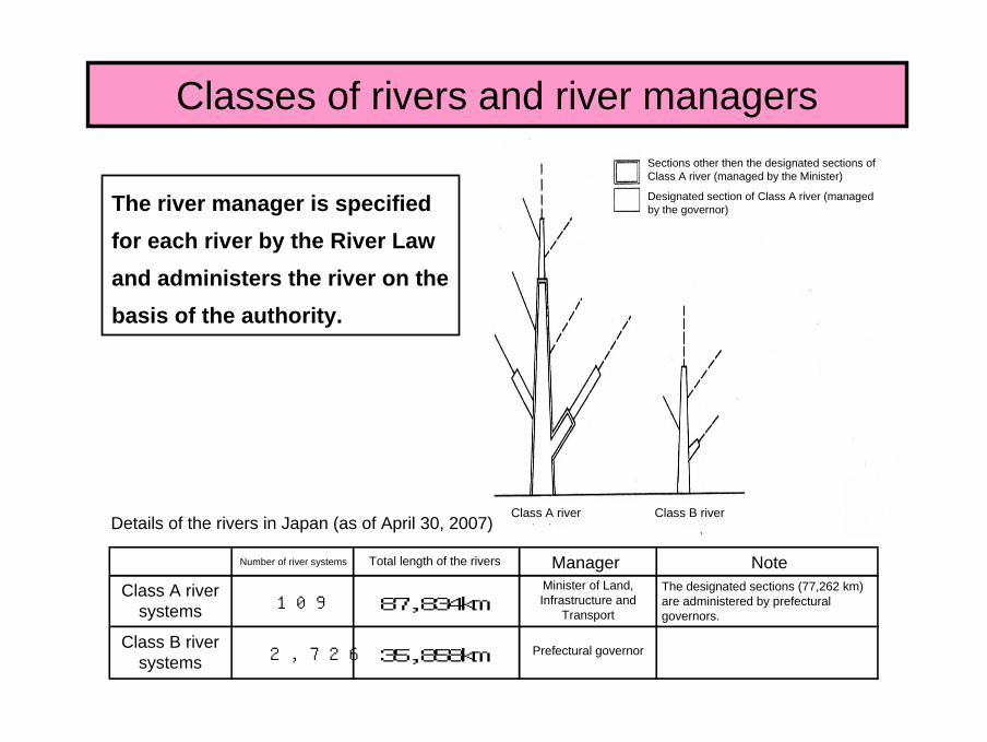
Classes of rivers and river managers
The river manager is specified for each river by the River Law and administers the river on the basis of the authority.
Details of the rivers in Japan (as of April 30, 2007)Class A river Class B river
Number of river systems Total length of the rivers Manager NoteClass A river
systems 109 87,834kmMinister of Land, Infrastructure and
Transport
The designated sections (77,262 km) are administered by prefectural governors.
Class B river systems 2,726 35,858km Prefectural governor
Sections other then the designated sections of Class A river (managed by the Minister)
Designated section of Class A river (managed by the governor)
Sections other then the designated sections of Class A river (managed by the Minister)
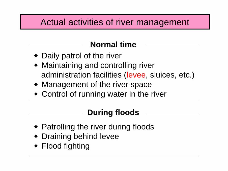
Actual activities of river management
◆Daily patrol of the river◆Maintaining and controlling river
administration facilities (levee, sluices, etc.)◆Management of the river space◆Control of running water in the river
◆Patrolling the river during floods◆Draining behind levee◆Flood fighting
Normal time
During floods
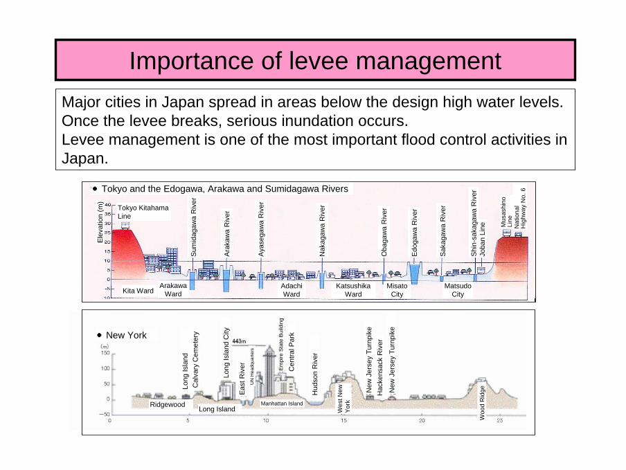
Importance of levee managementMajor cities in Japan spread in areas below the design high water levels.Once the levee breaks, serious inundation occurs.Levee management is one of the most important flood control activities in Japan.
●
●Tokyo and the Edogawa, Arakawa and Sumidagawa Rivers
Elev
atio
n(m
)
Tokyo KitahamaLine
Sum
idag
awa
Riv
er
Ara
kaw
a R
iver
Aya
sega
wa
Riv
er
Nak
agaw
a R
iver
Oba
gaw
aR
iver
Edog
awa
Riv
er
Saka
gaw
aR
iver
Joba
n Li
ne Mus
ashi
noLi
neN
atio
nal
Hig
hway
No.
6
Kita WardArakawa
WardAdachi Ward
Katsushika Ward
Misato City
Matsudo City
●New York
Long
Isla
nd
railw
ayC
alva
ry C
emet
ery
Long
Isla
nd C
ity
East
Riv
erU
N H
eadq
uarte
rs
Em
pire
Sta
te B
uild
ing
Cen
tral P
ark
Hud
son
Riv
er
New
Jer
sey
Turn
pike
Hac
kens
ack
Riv
er
New
Jer
sey
Turn
pike
Woo
dR
idge
Wes
t New
Y
orkRidgewood Long Island
Manhattan Island
Shin
-sak
agaw
aR
iver
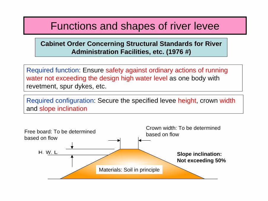
Required configuration: Secure the specified levee height, crown widthand slope inclination
Required function: Ensure safety against ordinary actions of running water not exceeding the design high water level as one body with revetment, spur dykes, etc.
Functions and shapes of river leveeCabinet Order Concerning Structural Standards for River
Administration Facilities, etc. (1976 #)
Slope inclination: Not exceeding 50%
Free board: To be determined based on flow
Crown width: To be determined based on flow
Materials: Soil in principle
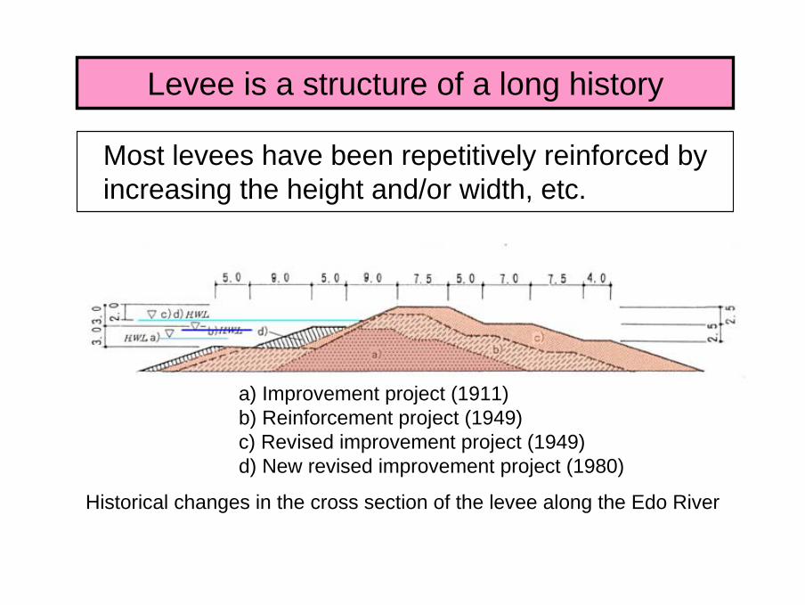
Levee is a structure of a long history
Most levees have been repetitively reinforced by increasing the height and/or width, etc.
a) Improvement project (1911)b) Reinforcement project (1949)c) Revised improvement project (1949)d) New revised improvement project (1980)
Historical changes in the cross section of the levee along the Edo River

Construction methods have differed depending on era.
Early 20th century (Tone River) 1940’s (Watarase River)
Today’s construction methods (Benching and roller compaction using tire rollers for expanding the width of the levee)
The construction methods of levees (for filling and compacting earth, etc.) have varied reflecting the technological and economical capabilities of the age.
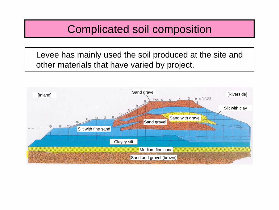
Complicated soil composition
Levee has mainly used the soil produced at the site and other materials that have varied by project.
[Inland]
Silt with fine sand
Clayey silt
Sand and gravel (brown)
Medium fine sand
Sand gravel
Sand gravel
Sand with gravel
[Riverside]
Silt with clay
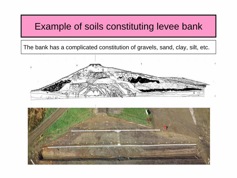
Example of soils constituting levee bank
The bank has a complicated constitution of gravels, sand, clay, silt, etc.
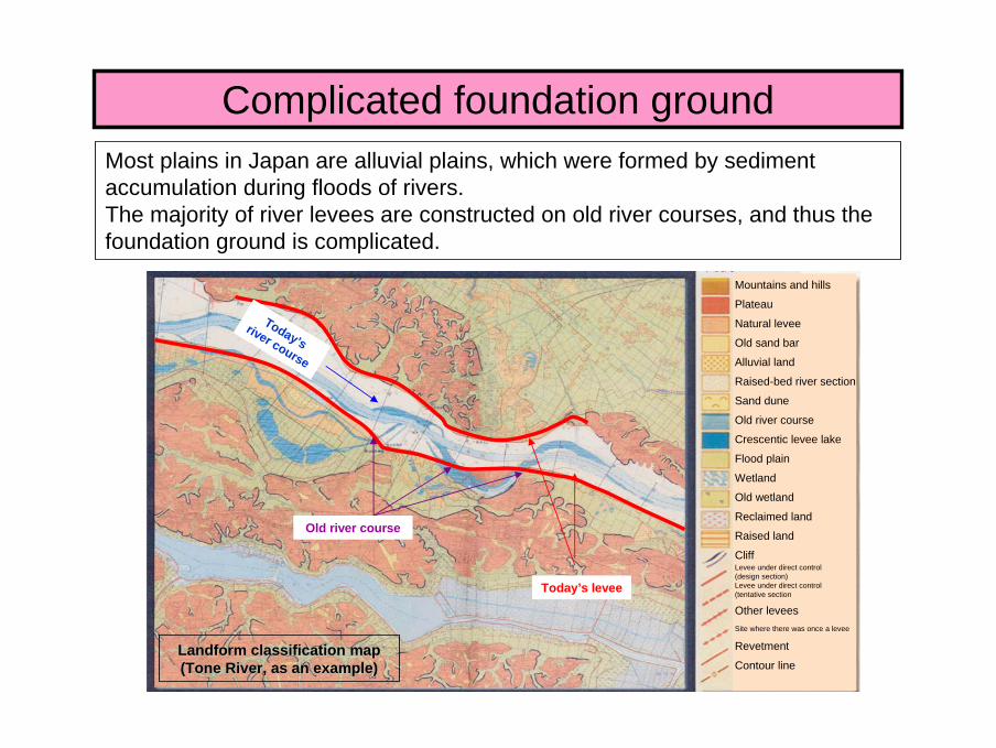
Complicated foundation groundMost plains in Japan are alluvial plains, which were formed by sediment accumulation during floods of rivers.The majority of river levees are constructed on old river courses, and thus the foundation ground is complicated.
Landform classification mapLandform classification map(Tone River, as an example)(Tone River, as an example)
Today’s levee
現河道
Old river course
Today’s river course
Mountains and hills
Plateau
Natural levee
Old sand bar
Alluvial land
Raised-bed river section
Sand dune
Old river course
Crescentic levee lake
Flood plain
Wetland
Old wetland
Reclaimed land
Raised land
CliffLevee under direct control (design section)Levee under direct control (tentative section
Other leveesSite where there was once a levee
Revetment
Contour line
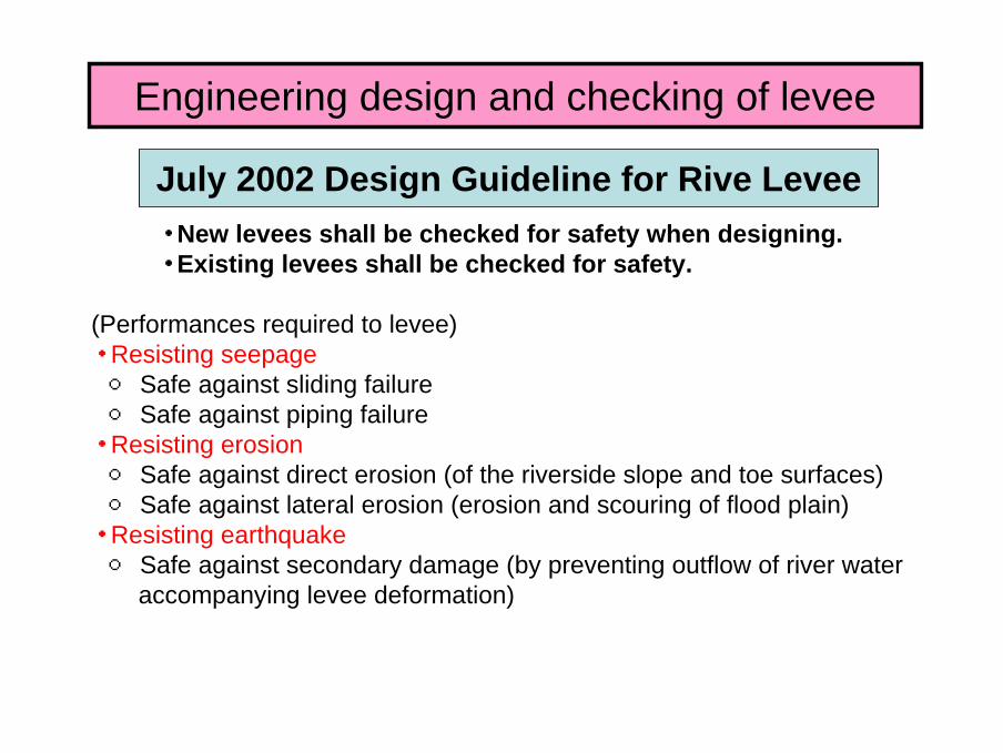
・ New levees shall be checked for safety when designing.・ Existing levees shall be checked for safety.
(Performances required to levee)・ Resisting seepage○ Safe against sliding failure○ Safe against piping failure・ Resisting erosion○ Safe against direct erosion (of the riverside slope and toe surfaces)○ Safe against lateral erosion (erosion and scouring of flood plain)・ Resisting earthquake○ Safe against secondary damage (by preventing outflow of river water
accompanying levee deformation)
July 2002 Design Guideline for Rive Levee
Engineering design and checking of levee
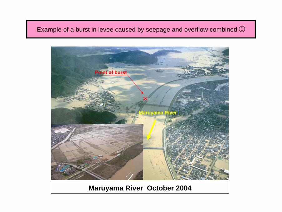
Example of a burst in levee caused by seepage and overflow combined①
Maruyama River October 2004
×
Point of burst
Maruyama River

Maruyama River October 2004
Example of a burst in levee caused by seepage and overflow combined②
Maruyama River
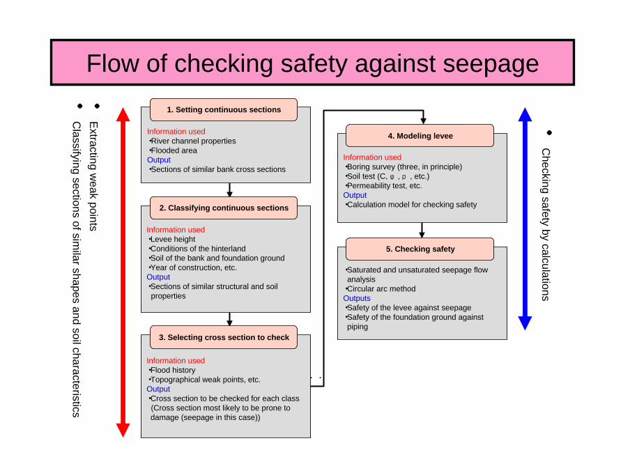
Flow of checking safety against seepage
・河道特性・洪水氾濫区域アウトプット・堤防の断面形状が同一の区間
・堤防の高さ・背後地の状況・堤体・基礎地盤の土質・築堤年代 etc..アウトプット・堤防の持つ構造的・土質的特性が同様の区間
・被災履歴・地形上のウィークポイント etc..アウトプット・細分区間における安全性照査断面 (求められる機能(この場合は浸透)に対して最も厳しい条件であると思われる箇所)
・ボーリング調査結果(原則3本)・土質試験(C、φ、ρ 等)・透水試験 etc..アウトプット・安全性照査実施のための計算モデル
・飽和・不飽和浸透流計算・円弧すべり計算アウトプット・堤体の浸透に対する安全性・基礎地盤のパイピングに対する安全性
●Extracting w
eak points
●Classifying sections of sim
ilar shapes and soil characteristics
●Checking safety by calculations
1. Setting continuous sections
Information used・River channel properties・Flooded areaOutput・Sections of similar bank cross sections
2. Classifying continuous sections
Information used・Levee height・Conditions of the hinterland・Soil of the bank and foundation ground・Year of construction, etc.Output・Sections of similar structural and soil properties
3. Selecting cross section to check
Information used・Flood history・Topographical weak points, etc.Output・Cross section to be checked for each class(Cross section most likely to be prone to damage (seepage in this case))
4. Modeling levee
Information used・Boring survey (three, in principle)・Soil test (C, φ, ρ, etc.)・Permeability test, etc.Output・Calculation model for checking safety
5. Checking safety
・Saturated and unsaturated seepage flow analysis・Circular arc method Outputs・Safety of the levee against seepage・Safety of the foundation ground against piping
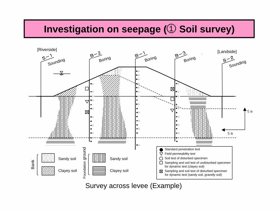
基礎地盤
堤
体
砂質土
粘性土
砂質土
粘性土
5m
5m
標準貫入試験現場透水試験乱した試料の土質試験乱さない状態での力学試験用試料の採取と土質試験(粘性土)乱した状態での力学試験用試料の採取と土質試験(砂質土、礫質土)
〔堤外側〕 〔堤内側〕
Survey across levee (Example)
Investigation on seepage (① Soil survey)
[Riverside]
Sounding Boring BoringBoring
Sounding
[Landside]
BoringBoring
Ban
k Sandy soil
Clayey soil
Foun
datio
ngr
ound
Sandy soil
Clayey soil
Standard penetration testField permeability testSoil test of disturbed specimenSampling and soil test of undisturbed specimen for dynamic test (clayey soil)Sampling and soil test of disturbed specimen for dynamic test (sandy soil, gravelly soil)

●● Assessment based on the safety factor calculated by the saturateAssessment based on the safety factor calculated by the saturated and d and unsaturated seepage flow analysis plus the circular arc methodunsaturated seepage flow analysis plus the circular arc method
Sliding failureSliding failure
Fs≧1.2×α1×α2 (Riverside slope)αα1:1:Coefficient of the bank history (1.0, 1.1, 1.2 Complicated # laCoefficient of the bank history (1.0, 1.1, 1.2 Complicated # larger value)rger value)
αα2:2:Coefficient of the foundation ground (1.0, 1.1 With dangerous lCoefficient of the foundation ground (1.0, 1.1 With dangerous landform # larger value)andform # larger value)
Investigation on seepage (② Checking safety)
Seepage flow analysis Circular arc method
Wat
er le
vel(
m)
Time (hr)Vertical line
Slip circle
Center of the slip circle
Center of gravity
Measured valueCalculated value(Unit: hour)

○ Of the entire levee of about 10,000 km, 8,800 km has been inspected for safety by the end of March 2008.○ About 3,500 km was found to be insufficient in safety against seepage.○ Inspection of the remaining 1,400 km will b completed by the end of fiscal 2009.
Present state of safety inspection along the rivers under the jurisdiction of the national government
An example of publishing sections requiring countermeasures (Yahagigawa River)
要対策箇所
要対策箇所要
対策箇所
要対策箇所
安全性照査基準未満
安全性照査基準以上
Not inspected yet1367km
14% Inspected and require
countermeasures3,554km
35%
Inspected and require no countermeasures
5,206km51%
Percentage of levee sections inspected for safety against seepage
(As of the end of March 2008)
Inspection completed
Prior section
Section requiring
measures
Safety standards satisfiedSafety standards not satisfied
Prio
r sec
tion
Sec
tion
requ
iring
m
easu
res
Section requiring
measuresSection requiring
measures
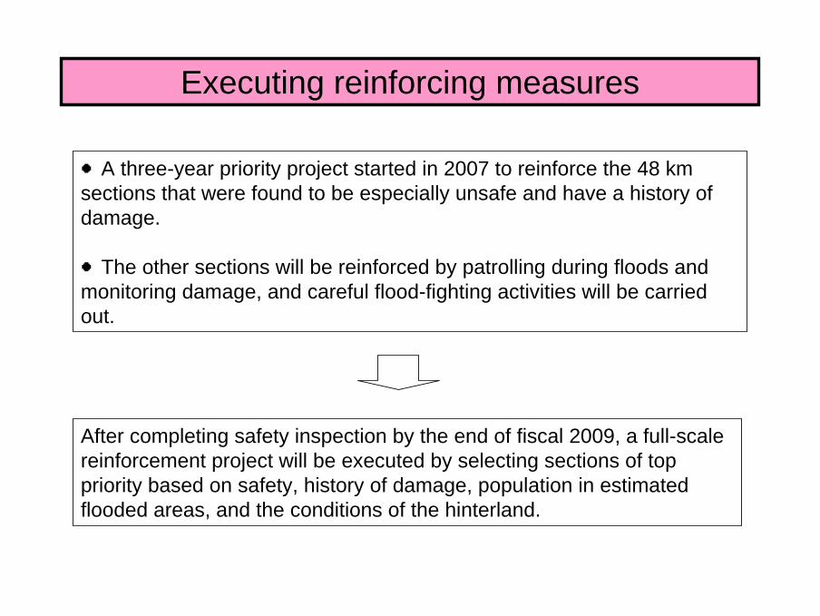
Executing reinforcing measures
●A three-year priority project started in 2007 to reinforce the 48 km sections that were found to be especially unsafe and have a history of damage.
●The other sections will be reinforced by patrolling during floods and monitoring damage, and careful flood-fighting activities will be carried out.
After completing safety inspection by the end of fiscal 2009, a full-scale reinforcement project will be executed by selecting sections of top priority based on safety, history of damage, population in estimated flooded areas, and the conditions of the hinterland.
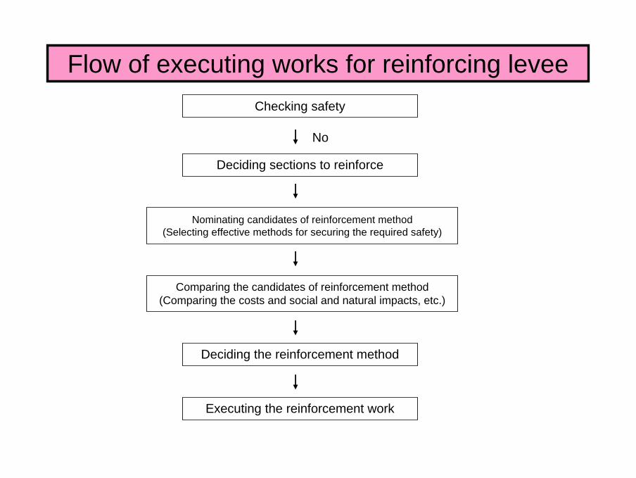
Flow of executing works for reinforcing leveeChecking safety
Deciding sections to reinforce
Nominating candidates of reinforcement method(Selecting effective methods for securing the required safety)
Comparing the candidates of reinforcement method(Comparing the costs and social and natural impacts, etc.)
Deciding the reinforcement method
Executing the reinforcement work
No
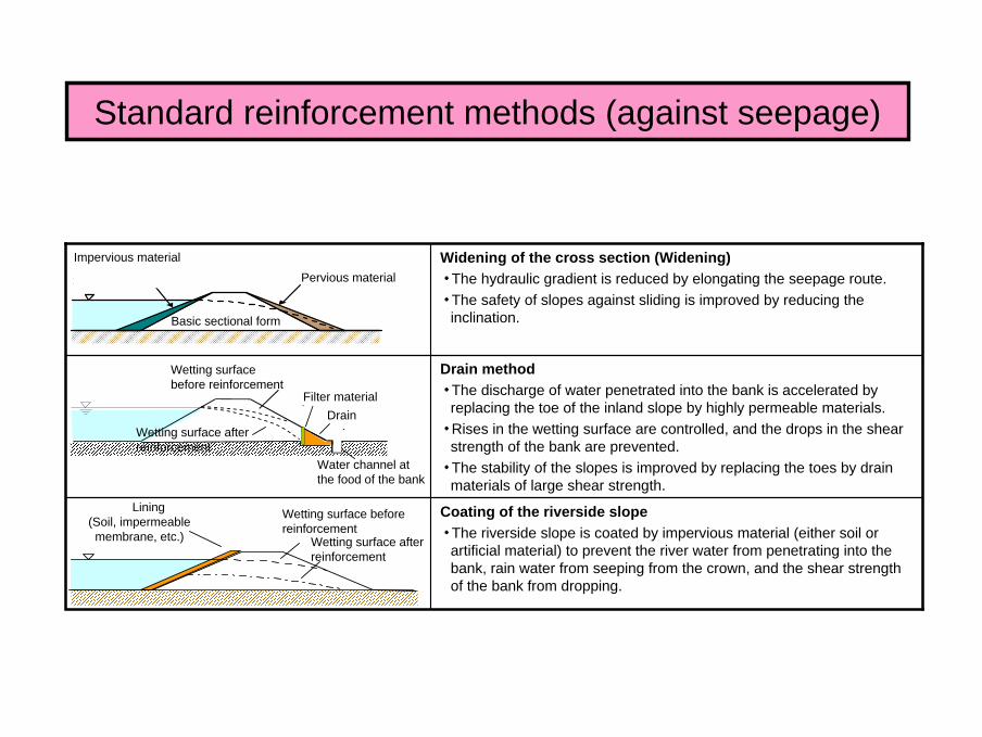
Standard reinforcement methods (against seepage)
Coating of the riverside slope・ The riverside slope is coated by impervious material (either soil or
artificial material) to prevent the river water from penetrating into the bank, rain water from seeping from the crown, and the shear strength of the bank from dropping.
Drain method・ The discharge of water penetrated into the bank is accelerated by
replacing the toe of the inland slope by highly permeable materials.・ Rises in the wetting surface are controlled, and the drops in the shear
strength of the bank are prevented.・ The stability of the slopes is improved by replacing the toes by drain
materials of large shear strength.
Widening of the cross section (Widening)・ The hydraulic gradient is reduced by elongating the seepage route.・ The safety of slopes against sliding is improved by reducing the
inclination.
■断面拡大工法
難透水性材料 透水性材料
基本断面形状
Pervious materialImpervious material
Basic sectional form
Wetting surface before reinforcement
Drain
Water channel at the food of the bank
Filter material
Wetting surface after reinforcement
Lining(Soil, impermeable membrane, etc.)
Wetting surface before reinforcement
Wetting surface after reinforcement
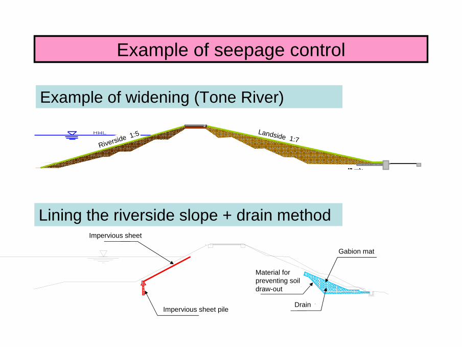
Example of seepage control
表のり面被覆+ドレーン工法による対策事例(木津川)
Example of widening (Tone River)
HWL
遮水シート
遮水矢板ドレーン
吸出し防止材
Lining the riverside slope + drain method
Gabion mat
Riverside 1:5 Landside 1:7
Impervious sheet
Impervious sheet pile
Material for preventing soil draw-out
Drain
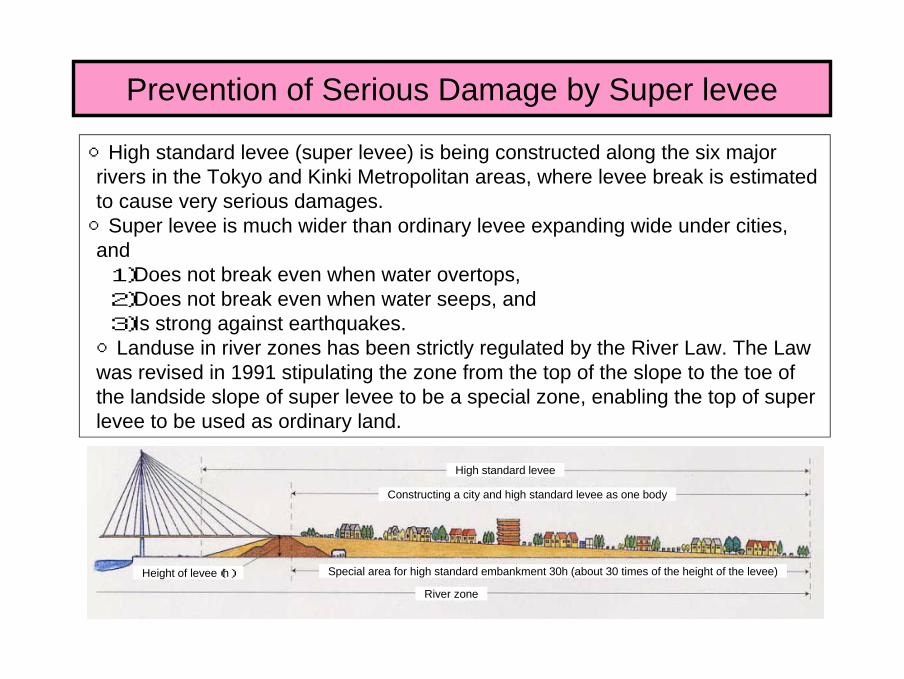
○High standard levee (super levee) is being constructed along the six major rivers in the Tokyo and Kinki Metropolitan areas, where levee break is estimated to cause very serious damages.○Super levee is much wider than ordinary levee expanding wide under cities, and1)Does not break even when water overtops,2)Does not break even when water seeps, and3)Is strong against earthquakes.○Landuse in river zones has been strictly regulated by the River Law. The Law was revised in 1991 stipulating the zone from the top of the slope to the toe of the landside slope of super levee to be a special zone, enabling the top of super levee to be used as ordinary land.
Prevention of Serious Damage by Super levee
High standard levee
Constructing a city and high standard levee as one body
Height of levee(h) Special area for high standard embankment 30h (about 30 times of the height of the levee)
River zone
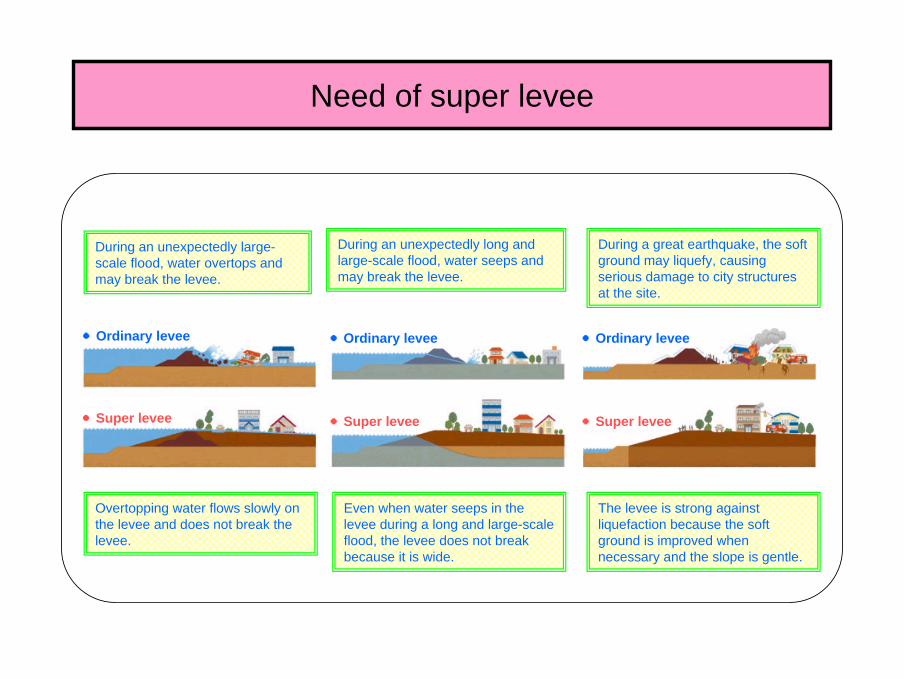
Overtopping water flows slowly on the levee and does not break the levee.
Even when water seeps in the levee during a long and large-scale flood, the levee does not break because it is wide.
The levee is strong against liquefaction because the soft ground is improved when necessary and the slope is gentle.
During an unexpectedly large-scale flood, water overtops and may break the levee.
During an unexpectedly long and large-scale flood, water seeps and may break the levee.
During a great earthquake, the soft ground may liquefy, causing serious damage to city structures at the site.
●Ordinary levee ●Ordinary levee●Ordinary levee
●Super levee ●Super levee●Super levee
Need of super levee
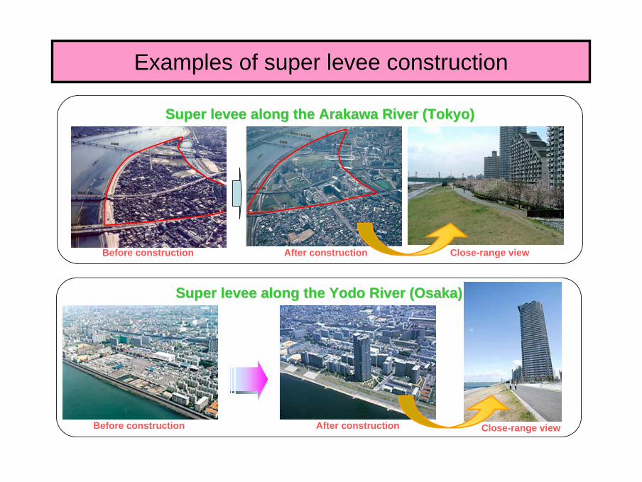
Super levee along the Arakawa River (Tokyo)Super levee along the Arakawa River (Tokyo)
Super levee along the Super levee along the YodoYodo River (Osaka)River (Osaka)
Before construction After construction Close-range view
Before construction After construction Close-range view
Examples of super levee construction
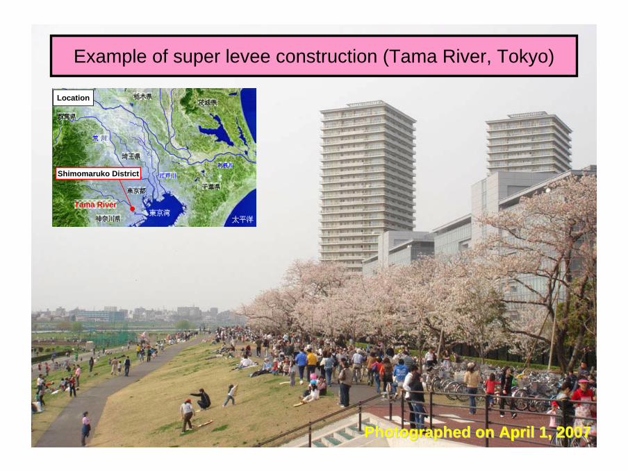
Photographed on April 1, 2007Photographed on April 1, 2007
Example of super levee construction (Tama River, Tokyo)
東京湾太平洋
利根川
千葉県
神奈川県
東京都
栃木県茨城県
荒荒 川川
埼玉県
江戸川
Tama River
群馬県
Location
Shimomaruko District

Monitoring levee
根固工張芝
▽ H.W.L.
護岸工
【堤外】 【堤内】
堤体
基礎地盤
▽ H.W.L.
Besides visual monitoring, some levees are monitored using measuring instruments.
[Erosion]
[Seepage] Water gauges in the bank
Ground water level gauge
River water gauge
Scouring sensor
Monitoring the surface velocity
River water gauge
Erosion sensor
[Riverside]
Bank
[Landside]
Foundation ground
Foot protectionRevetment Sodding
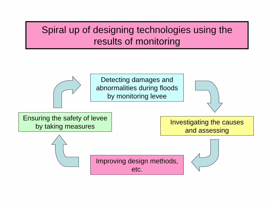
Spiral up of designing technologies using the results of monitoring
Detecting damages and abnormalities during floods
by monitoring levee
Investigating the causes and assessing
Improving design methods, etc.
Ensuring the safety of levee by taking measures

Number of breaks per year for each decade after 1945
0
50
100
150
200
250
45~54 55~64 65~74 75~84 85~94 95~
Reference: Actual states of breaking of dykes WWII (2002, River Improvement and Management Division)
230 Total: 678 breaks (from the data of the national and prefectural governments)
107 11289
6179
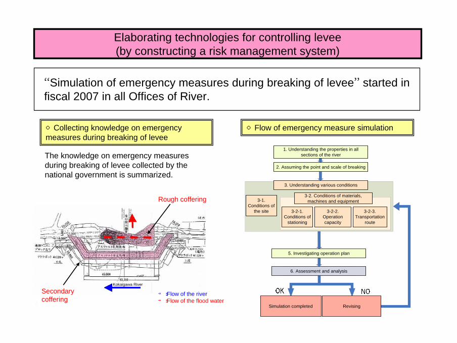
“Simulation of emergency measures during breaking of levee” started in fiscal 2007 in all Offices of River.
Elaborating technologies for controlling levee(by constructing a risk management system)
○Collecting knowledge on emergency measures during breaking of levee
The knowledge on emergency measures during breaking of levee collected by the national government is summarized.
○Flow of emergency measure simulation
Rough coffering
Secondary coffering
→:Flow of the river→:Flow of the flood water
Kokaigawa River
1. Understanding the properties in all sections of the river
2. Assuming the point and scale of breaking
5. Investigating operation plan
6. Assessment and analysis
3. Understanding various conditions
3-2. Conditions of materials, machines and equipment3-1.
Conditions of the site 3-2-1.
Conditions of stationing
3-2-2. Operation capacity
3-2-3. Transportation
route
Simulation completed Revising
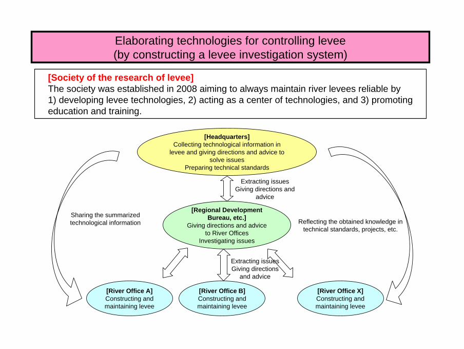
Elaborating technologies for controlling levee(by constructing a levee investigation system)
[Society of the research of levee]The society was established in 2008 aiming to always maintain river levees reliable by 1) developing levee technologies, 2) acting as a center of technologies, and 3) promoting education and training.
[River Office B]Constructing and maintaining levee
[Headquarters]Collecting technological information in
levee and giving directions and advice to solve issues
Preparing technical standards
[Regional Development Bureau, etc.]
Giving directions and advice to River Offices
Investigating issues
[River Office A]Constructing and maintaining levee
[River Office X]Constructing and maintaining levee
Extracting issuesGiving directions
and advice
Extracting issuesGiving directions and
advice
Sharing the summarized technological information Reflecting the obtained knowledge in
technical standards, projects, etc.