Embed Size (px)
Citation preview
371 Gulf Coast Association of Geological Societies Transactions, Volume 54, 2004
Within Five Years, Hydrate Exploitation can be a Reality in the Northern Gulf of Mexico
Lowrie, A.,1 Dean, P. A.,2 and Lutken, C. B.3
1Consultant, 238 F. Z. Goss Road, Picayune, Mississippi 39466, [email protected], P. O. Box 305, Waveland, Mississippi 39576, [email protected] for Marine Resources and Environmental Technology, CMRET, University of Mississippi,University, Mississippi 38677, [email protected]
AbstractHydrates and associated free gases exist within the shallow sub-surface in waters deeper
than 100-500m up to 2-3km. Forces impacting hydrate occurrence include chemistry of the origi-nal natural gases and the temperature/pressure regime within which these exist. At depths circaone to two km, the hydrate stability zone is approximately 100 to 300m thick, respectively, withgas trapped beneath the hydrate.
Along the northern Gulf of Mexico continental margin, hydrates are abundantlydescribed. Seismic reflection and drilling data are adequate to locate and map hydrates and freegases.
Hydrate exploitation requires converting hydrates into free gases or harvesting gases asso-ciated with hydrates. Exploration involves locating and measuring exploitable potentialreservoirs. Exploitation involves determining both the likelihood of removing gases safely and thestructural integrity of the area being mined. A structural collapse and consequent catastrophicrelease of trapped gases would impact both continental margin stability and global climate. Inboth phases, judicious application of vertical and horizontal/inclined drilling is mandatory.
Seafloor and subsurface monitoring systems must be utilized before, during, and after theexploitation phase and include a seismic network and boreholes equipped for subsurface monitor-ing of temperatures/pressures migrating in the section. Monitoring of changes within the marginmay be sufficient to prevent failure and maintain stability and continuity of the reservoir beingexploited. With state-of-the-art monitoring via seismic reflection and boreholes, hydrates can beexploited successfully, with present technology, within five years.
Background
The northern Gulf of Mexico is a known petroleum producer. Thus, geologic conditions appro-priate for the generation, migration, and entrapment of hydrocarbons are present. The raw materials forhydrates and associated natural gases are available, regionally. Hydrates are well-documented from sea-floor bathyscaph surveys and penetration by exploratory drilling wells and inferred from high to ultra-high seismic reflection data (Lutken et al., 2003). The probability of major, even massive, hydratereserves in the world ocean basins (Brown et al., 1996; Lowrie and Max, 1999; Max and Lowrie, 1992and 1996) and the northern Gulf is conjectured, not verified.
Hydrate in the marine environment exists across the continental slope. Continental shelves aregenerally too shallow with inadequate pressure and overlying warm waters to permit hydrate habitation(Max and Lowrie, 1992). The much deeper continental rises and abyssal plains under massive pressuresinhibit hydrate formation; the buoyant gases remain in solution and continue to rise upward into theoverlying oceans (Ian Lerche, U. South Carolina, Retired, telephone communication, January, 2002).Hydrocarbon exploration and exploitation have continued to proceed into ever-deeper waters and sub-surface, traversing down the continental margin and across the slope. Thus, petroleum exploration pro-ceeds into the realm of hydrates.

Lowrie et al.
372
Hydrates are a hindrance to classical petroleum exploration in the search for deep-lying oil and/or natural gas reservoirs. Yet the hydrates and associated free gases are a potential hydrocarbon reser-voir awaiting exploitation with existent technologies and scientific understandings.
There is a need to determine/develop a template/scheme by which hydrates and associated gasesmay be exploited, profitably. In developing such an initial template, as is being conducted here, there isa need to identify, describe, and measure the potential reservoir(s) themselves, the geologic discontinui-ties that may impact reservoir production, and those geologic processes that may become activated anddisruptive during the extraction phase. As with any hydrocarbon production, exploitation of hydrate andthe associated free gas require detailed determination of reserve availability and its reservoiring andtrapping characteristics. A unique aspect of hydrate-based production is its proximity to the seafloor.Such proximity to the seafloor means that as production occurs, gases are removed. The removal itselfcould impact the continental slope stability by initiating faulting and/or slump blocks. Should such tec-tonics occur, then not only may the slope structural stability be impaired, but the stability of the hydrate,serving as the free gas trap, may also be damaged. Detailed monitoring of the production and of regionalstability must characterize the entire venture.
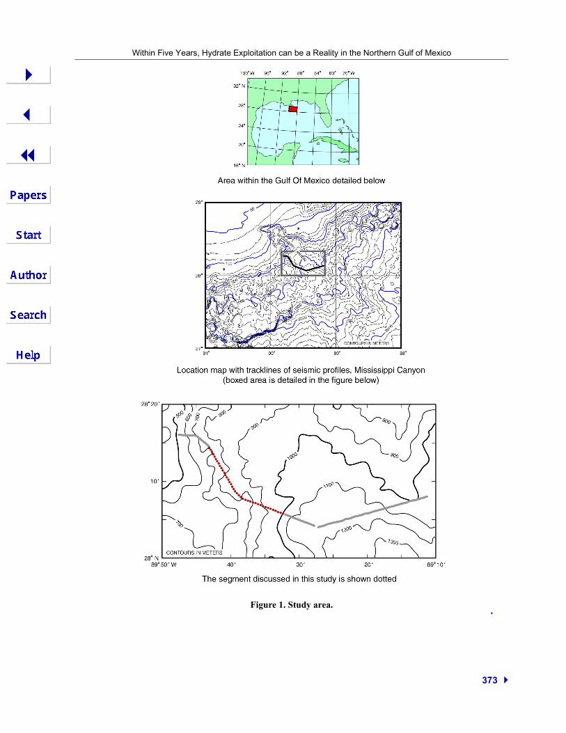
Interwoven within the proposed exploitation template will be references to surveys already con-ducted by the Center for Marine Research and Environmental Technology (CMRET)/ MississippiMineral Resource Institute, University of Mississippi to locate hydrates and their associated free gasesalong the flanks of and along the Mississippi Canyon within the Mississippi Canyon Federal Lease Area(see Fig. 1). These efforts are funded by the Minerals Management Service, Department of the Interior(DOI), by the National Energy Technology Laboratory, a division of the Department of Energy, and theNational Institute for Undersea Science and Technology of the National Oceanographic and Atmo-spheric Administration (NOAA). Thus, expertise in the exploration phase has already been acquired(Geresi et al., 2002; Lutken et al., 2003; Lowrie et al., 2002). An example of data employed in thesesearches is in Figure 2, a single channel seismic line, collected at industry frequencies and employing a35/35 GIgun and 24-channel streamer, using U. S. Geological Survey, Menlo Park equipment and pro-cessed by CMRET. A grounding failure in the connector of the multi-channel streamer addedappreciable noise to the data. The data examined came from the quietest of the 24 channels after metic-ulous editing of the data and processing thereof.
Hydrate Exploration/Exploitation
How and Where do Gas Hydrates Occur?
Two current paradigms are considered in this study:
• “Steady-state” hydrate and associated free gas accumulated and maintained in relatively unde-formed/undeforming sediments, and
• Dynamic flow-through of fluids along conduits/open faults in deformed/deforming sediments(possible hydrate mounds develop along flanks of open faults).
Both paradigms require deep-sourced—>1 km—hydrocarbon sources; natural gases rising atvery dissimilar rates ranging from cm/m per day to mm/cm per 1000 years.
How can Hydrates/Free Gases be Located?
Data applicable to locating hydrates and associated free gases are known (e.g., Geresi et al.,2002; Lutken et al., 2003) and are listed below.
• Seismic reflection data at frequencies from 3.5 Hz to 10-80 Hz (single to multi- channel data).
• Horizontal and/or vertical, seismic arrays data.
• Core and well-log data.
• Geochemical analyses of fluids, both water-column and pore-water: types and amounts.
Within Five Years, Hydrate Exploitation can be a Reality in the Northern Gulf of Mexico
373
Figure 1. Study area.

374
Lowrie et al.
Figure 2. Uninterpreted single-channel (GIgun) seismic profile oriented approximately west to east across the central Mississippi Canyon.
Within Five Years, Hydrate Exploitation can be a Reality in the Northern Gulf of Mexico
375
What are the Exploration Objectives?
Hydrates and free gases may apparently accumulate in both sands and shales:
• Sands—accumulations within interstices between sand grains, including “ratty sands/low resis-tivity sands” (sands including a majority of shales).
• Shales—vertically-oriented “polygonal faulting” of minute movements/jointing located withinthe sedimentary column from shallowest sub-surface to at least several km depths; often locatedwithin slightly dipping formations; gases may be located within faults/joints, e. g., see Van Rens-berger et al., 2003 for emerging discussion.
Exploration/Exploitation ConcernsPractical exploitation of hydrates and associated free gases from the northern Gulf of Mexico:
• Is here proposed to be possible with existing extractive technology and scientific awareness ofhydrate occurrence and structural weaknesses.
• Concerns dealing with environmental impacts, principally from gases escaping minutely to mas-sively into the ocean; however, may be eased by careful monitoring of the production itself and ofthe overburden.
• Assumes exploration, exploitation, and monitoring to be performed using judiciously combinedcoring, drilling, and seismic reflection data of differing frequencies and detailed interpretations.Techniques for excellent data acquisition and interpretation are presently available.
Hydrate/Free Gas Exploitation Template ObjectivesComponent parts/steps of a hydrate/free gas exploration/exploitation template as proposed here
include:
• Summarize information pertinent to hydrate and associated free natural gas occurrence and theirlocations, exploitation using horizontal/inclined wells, and subsequent monitoring, employingthe well-understood rules of hydrocarbon source, reservoir, and trap.
• Understand and list/map geo-hazards that may impact hydrate and free gas extraction and thesurrounding region, both during exploitation and subsequent to it.
• Describe techniques and equipment required for successful and safe exploitation and monitoring.
Discussion of Proposed Exploitation Template Objectives
Objective A
Essential to this proposed exploration/exploitation template is the application of the knowledgedescribed above with the time-honored triumvirate of hydrocarbon exploration of source, reservoir, andtrap. The regional geology of the northern Gulf of Mexico is sufficiently well-known so that regionssuitable for hydrate formation may be identified. Emphasis is made of the difficulty in determining theexistence of hydrates. Three interpretative scenarios are here described:
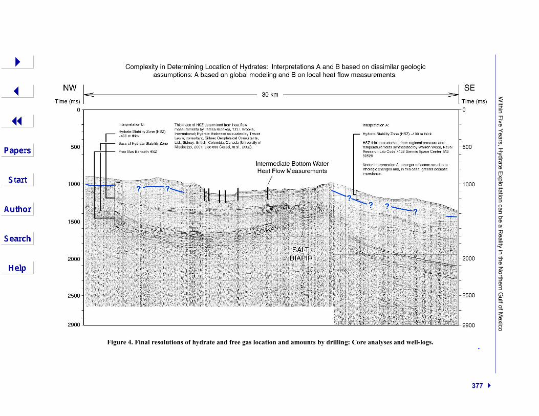
• Based on regional mid-latitude oceanographic (Knauss, 1978) and geologic temperature andpressure regimes, Warren Wood (U. S. Naval Research Labs at the Stennis Space Center, Missis-sippi) has indicated that at a depth of circa one km, the thickness of a pure methane hydrate sta-bility zone (HSZ) should approximate 100 m (Fig. 3),
• Should there be some contamination by ethane and/or butane, the HSZ may be doubly thick, and• Based on heat-flow measurements along a portion of the seismic profile presented in Figure 2,
the HSZ is calculated to be as much as 400m thick (TDI Brooks, International, Inc., 2001). Insummary, here are three acceptable HSZ thicknesses none verified by measurements (Fig. 4).Once identified, regions of hydrate-forming characteristics are to be explored in detail, high-
grading those local areas of hydrate potential. In such local areas, the hydrocarbon source(s), reser-voir(s), and trapping mechanisms within a hydrate-occurring geologic situation are to be categorizedand mapped.

Lowrie et al.
376
Figure 3. The empirical methane hydrate stability curve of Brown et al. (1996) is plotted with an empiricalestimate of water column temperature as a function of depth and absolute latitude derived from Knauss(1978). The blackened regions indicate methane hydrate stability zones for about 900 and 2000m water depthassuming a constant geothermal gradient of 0.054mK/m. The zone is thicker and contains methane hydratethat is more securely sequestered (further from the stability boundary) than the shallower site. The sequestra-tion of the deeper water area is enhanced by its distance from the intermediate bottom water, the ocean layermost likely to exhibit a climate-related temperature change (prepared by Warren Wood).
Within F
ive Years, H
ydrate Exploitation can be a R
eality in the Northern G
ulf of Mexico
377
Figure 4. Final resolutions of hydrate and free gas location and amounts by drilling: Core analyses and well-logs.

Lowrie et al.
378
The data-types needed are principally two: seismic reflection data and the geological ground-truth sampling from bore-holes penetrating and sampling the geophysically identified hydrate and/orfree gas reservoir, the overburden section, and some penetration into the economic basement, to ascer-tain characteristics of the deeper sub-surface influences impacting the reservoir and its overburden.Once the wells are drilled, geomechanical and geochemical parameters such as temperatures, pressures,and fluid-flow amounts and types need to be measured at a frequency such as every 100 feet (~30m).
The data-collection may be considered in three phases:
• Stage 1: 2-D high-frequency seismic reflection data, both single and multi-channel (with whichto obtain velocity data), collected on a regional basis and interpreted initially to identify andlocate hydrates and associated gas reservoirs and subsequently, to identify and locate potentialgeo-hazards that may hamper, in any phase, the life of the hydrate reservoir (see objective bbelow). Once the geophysical data are interpreted, regional vertical exploratory wells, to verifygeologic interpretations, are to be drilled in appropriate locations and through the section ofinterest (Fig. 5).
• Stage 2: involves the collection of 3-D, or semi-3-D, high-frequency data over the interpreted andmapped hydrate prospect prior to exploratory drilling with an exploitative pattern of horizontal/inclined wells to be drilled once the 3-D seismic data are interpreted (Fig. 5). A suggested exploi-tation drilling pattern is shown in Figure 6; after the initial horizontal/inclined well is drilled andavailable gases captured, a second well, possibly paralleling the first, may be drilled and excessfluids pumped into the first well, maintaining environmental cleanliness and structural strength ofthe sub-surface. The remainder of the field could be similarly exploited. The exploitation objec-tive here is to collect from the zone of free gas beneath the hydrates. Exploitation within thehydrate itself may involve very innovative efforts not pursued here (see Max and Lowrie, 1997).
• Stage 3: involves the “maintaining” of a 4-D high-frequency seismic data-set once the reservoir isbeing routinely exploited; this detailed data-set is to facilitate monitoring the extraction itself andthe possible initiation of potentially disruptive geologic processes that can interfere with theextraction phase and/or create environmentally harmful conditions. Specific monitoring wellscould be drilled (existent wells may be so employed).
Objective B
A geo-hazard is a natural and routine geologic occurrence that interferes with a human activity,an activity such as hydrate exploration and exploitation. In order to define and quantify geo-hazards, itis mandatory that there be a complex and dynamic understanding of the regional and local geologic evo-lution and the several geologic processes involved in the evolution. The evolutionary models of thenorthern Gulf of Mexico are quite detailed and are becoming ever-increasingly more sophisticated.These models will need to be data-mined to categorize existent geo-hazards on both regional and localscales and how they modify the environment through time.
Objective C
Techniques and equipment for exploration and subsequent monitoring are presently availablewith many to be considered as available “off the shelf.” For the exploration phase, high resolution seis-mic reflection data are the most essential. The proposition here is that high resolution data are to becollected in the selected local areas of hydrate potential. Once collected and processed, detailed inter-pretation is to proceed. With hydrate and associated gases interpreted to be present, verification willcome from vertical wells drilled through the section of interest with the collection of cores especiallyequipped to entrap in situ gases in their pristine pressure and temperature environments.

Within F
ive Years, H
ydrate Exploitation can be a R
eality in the Northern G
ulf of Mexico
379
Figure 5. Monitoring of sediment stability by repeated seismic measurements and within overlying oceanic waters. Verification of hydrates and free gasby vertical drilling and sampling; natural gas exploitation by horizontal/inclined drilling through unconsolidated sediments; drilling not requiring anultra-strong drill-string.

Lowrie et al.
380
Figure 6. Map view of schematic plan for hydrocarbon collection from mapped reservoir of hydrates/associatedfree gas and re-injection/formation fluid recycling, maintaining formation pressure/structural integrity and anabsence of environmental degradation. Reservoir composed of unconsolidated sand and shales (silts and clays)containing natural gases in hydrate (solid) and free gas (the hydrate serving as the trapping mechanism). Afterhorizontal/inclined well #1 is drilled and hydrocarbons removed, then horizontal/inclined well #2 is drilled,hydrocarbons removed and re-injection/fluid re-cycling into horizontal/inclined well #1 (maintaining formationpressure/ structural integrity). The pattern of drilling, hydrocarbon collection, and excess fluids re-pumpedinto sub-surface along now-abandoned well(s) can continue across the mapped gas-bearing reservoir.
With “ground truth” establishment of hydrate and gas occurrence, actual reservoir mapping canbegin in earnest. Depending on requirements developed within the context of this proposal, the reservoirmapping may proceed once a 3-D seismic data-set is collected. Once the reservoir is mapped, exploita-tion proceeds. Extraction of the hydrocarbons will be from within the hydrate itself and/or from the freegases lying beneath the frozen hydrate. Technologically the easier option appears to be the extraction offree gases trapped beneath the crystalline hydrate. Monitoring the reservoir extraction and its impact onthe overburden will be conducted by 4-D 4-C ocean-bottom mounted seismic data-collection. To reviewthe seafloor itself, there can be periodic passes made by bathyscaphs to provide visual inspections andgeochemical and geophysical transects supplemented by similar routine surveillance from remotely-operated vehicles (ROVs) and/or autonomous underwater vehicles (AUVs).
Summary
The purpose of this proposal for hydrate/free gas exploitation is multifaceted: refining geologicmodels of the northern Gulf of Mexico so as to high-grade those zones that are and/or appear to behydrate-generative, following the classical rules of hydrocarbon exploration, and then the in-gatheringof data, models, and techniques with which to locate, measure, and then monitor hydrates and theirassociated gases during the active phases of exploration, exploitation, and finally post-exploitation.

Within Five Years, Hydrate Exploitation can be a Reality in the Northern Gulf of Mexico
381
The proposition here is that existent knowledge and techniques are fully sufficient to proceedwith hydrate exploitation. Mapping of suitable areas for exploration and a detailed understanding ofgeo-hazards that may impact hydrate extraction at any point along the multi-year effort needs to be com-pleted (see Geresi et al., 2002; Lutken et al., 2003 for examples of initial detailed mapping). Thecombined extraction-monitoring phase will require sophisticated and subtle data and their interpreta-tion, both of which are understood to be present at this time or in the near future. Hydrate exploitationwithin five years can be a reality with available abilities.
Acknowledgments
The data evaluated in this study were collected by the CMRET, University of Mississippi,together with the US Geological Survey, and were processed by the CMRET. Pat Hart, USGS, MenloPark, provided data and navigation files necessary to the study. The ongoing research of gas hydrates inthe northern Gulf of Mexico, of which this study is a part, is supported by Minerals Management Ser-vice, Department of the Interior, by the National Energy Technology Laboratory, Department of Energy,and, most recently by the National Undersea Research Program, a division of NOAA. The illustrationswere prepared and/or adapted for the project by Paul Mitchell, CMRET technical design specialist.
References
Brown, K. M., N. L. Bangs, P. N. Froelick, K. A. Kvenvolden, 1996, The Nature, Distribution, and Origin of GasHydrates in the Chile Triple Junction Region, Earth and Planetary Science Letters, v. 139, p.471-483.
Geresi, E., C. Lutken, T. McGee, and A. Lowrie, 2002, Complex Geology and Gas Hydrate Dynamics CharacterizeMississippi Canyon Block 798 on the Upper Continental Slope of the Northern Gulf of Mexico, Transac-tions, Gulf Coast Assoc. Geol. Soc., v. 52, p. 309-321.
Knauss, J., 1978, Introduction to Physical Oceanography, Prentice Hall, Inc., 338 p.Lowrie, A., and M. D. Max, 1999, The Extraordinary Promise and Challenge of Gas Hydrates, World Oil, v. 220,
no. 9 (September 1999), p. 49-55.Lowrie, A., C. Lutken, E. Geresi, R.H. Bennett, R. Faas, T. McGee, 2002, Natural Gas Hydrates: Permanent Earth Con-
stituents Impacting Sediment Strength and Continental Margin Evolution, CSEG/Recorder, v. 27, p. 13-37.Lutken, C., A. Lowrie, E. Geresi, R. Bennett, R. Faas, B. Battista, and T. McGee, 2003, Interpretation of High-Res-
olution Seismic Data from a Geologically Complex Continental Margin, Northern Gulf of Mexico, Transac-tions, Gulf Coast Assoc. Geol. Soc., v. 53, p. 504-516.
Max, M. D., and A. Lowrie, 1992, Natural Gas Hydrates: Arctic and Nordic Sea Potential, Arctic Geology andPetroleum Potential, T. O. Vorren, E.Gergsager, S. A. Dahl-Stammes, E. Holtzer, B. Johnsen, E. Lie, and T.B. Land (eds.), NPF Special Publication 2, Elsevier, Amsterdam and Norwegian Petroleum Society (NPF),p. 27-53.
Max, M. D., and A. Lowrie, 1996, Oceanic Methane Hydrates: A “Frontier” Gas Resource, Jour. Petroleum Geol-ogy, v. 19, no. 1 (January), p. 41-56.
Max. M. D., and A. Lowrie, 1997, Oceanic Methane Hydrate Development: Reservoir Character and Extraction,Proceedings, Offshore Technology Conference (OTC 8011), v. 28, p. 485-491.
TDI Brooks, International, Inc., 2001, Unpublished data acquired for The University of Mississippi, MississippiCanyon Heat-Flow Program, 2000, Technical Report 01-697.
Van Rensbergen, P., R.R. Hillis, A.J. Maltman and C.K. Morley, eds., 2003, Subsurface Sediment Mobilization,Geological Society Special Publication 216, The Geological Society-London, 522pp.


![Methane Hydrate in Confined Spaces ‐ An …...methane hydrate may be twice that of all other fuels combined.[6] Indeed, the future exploitation of methane hydrate from marine turned](https://img.pdfslide.net/doc/110x75/5fbd4d959cef473df80642b6/methane-hydrate-in-confined-spaces-a-an-methane-hydrate-may-be-twice-that.jpg)