Embed Size (px)
Citation preview
DRAFT
Wivenhoe Conservation Area Appraisal and Management Guidelines
March 2007
Contents
Part A: Conservation Area Appraisal
1.0 Introduction 1
2.0 Planning Policy Framework 2
3.0 Defi nition of Special Interest 3
4.0 History 4
5.0 Archaeology 7
6.0 Location and Setting 8
7.0 Townscape Analysis 9
8.0 Key Characteristics 25
9.0 Proposed Boundary Changes 30
Part B: Management Guidelines
10.0 Introduction 31
11.0 Article 4 Directions 32
12.0 Enhancement Opportunities 34
13.0 Policy Guidance 36
14.0 Urgent Works and Repairs Notices 38
15.0 References 39
Maps
Fig.1 Townscape Analysis
Fig.2 Character Areas
Fig.3 Land Use
1
1.0 Introduction
1.1 Wivenhoe Conservation Area was fi rst designated in 1969 with several amendments in 1980, 1987 (enlargement to include Cook’s shipyard), 1994 (enlargement to include Wivenhoe Station) and 1997.
1.2 This document aims to fulfi l Colchester Borough Council’s duty to ‘draw up and publish proposals for the preservation and enhancement’ of the area as required by the Planning (Listed Buildings and Conservation Areas) Act 1990. It should be read in conjunction with the ‘Management Guidelines for the Wivenhoe Conservation Area’ which has been produced to accompany this Appraisal.
1.3 This document includes: a review of the boundaries of the area, a character appraisal and policies for the management and monitoring of the area in order to preserve its character.
1.4 This section to describe the public consultation which has been carried out…
PART A: CONSERVATION AREA APPRAISAL
2
2.0 Planning Policy Framework
What are Conservation Areas?2.1 Conservation Areas are defi ned as ‘areas of special architectural or historic
interest, the character or appearance of which it is desirable to preserve or enhance’.
2.2 When a Conservation Area has been designated, it increases the Council’s controls, with planning applications judged by their impact on the character and appearance of the area. Greater controls over the demolition of buildings and structures are imposed whilst the rights which owners have to do works to their properties without planning permission (known as ‘permitted development rights’) are reduced or can be taken away. Stricter controls are also exercised over the design of new buildings, and owners must give the Council six weeks’ notice of their intention to carry out works to trees. Planning applications affecting a Conservation Area must be advertised on site and in the local press to give people the opportunity to comment.
What is a Conservation Area Appraisal?2.3 Having established a Conservation Area Local Planning Authorities are also
required to review the designation and boundaries of the area. This is to ensure the area is still considered to be of value and to consider whether any areas have been overlooked or changes have occurred which need the boundaries to be redrawn. Any pressures for change in the area can thus be identifi ed and enhancement opportunities highlighted.
2.4 The appraisal document sets out the historical and economic context for the locality and identifi es what it is that makes the Conservation Area of special interest. It serves to provide clear guidance on what should be conserved in the area, with specifi c Development Control policies devised to help assess planning applications in the area.
3
3.0 Definition of Special Interest
3.1 Wivenhoe is an attractive small port town which retains its maritime character along the quay area. The quay, together with Anchor Hill (the former marketplace) is the focus of the town and forms a picturesque scene with St Mary’s Church tower and cupola dominant above the rooftops.
3.2 Wivenhoe’s built fabric falls into two distinct eras resulting in two main character areas; C19 development and the earlier historic core. The historic core contains the older vernacular buildings and the street pattern is irregular and centred around the quay and former market place. The C19 streets are by contrast, generally more formal with buildings of polite architectural styles lining the often straight streets.
3.3 The infl uences of different historical periods and events, both national and local, are evident in the street pattern and buildings that are found throughout the town. Of underlying importance to the town is its estuarine location which has defi ned its form and the types of buildings that developed as a result of its maritime origins.
3.4 Later developments such as the railway led to the expansion of the town, whilst the development of the Wivenhoe House estate created a whole new quarter
of the town. These important events and many others such as the recent development of the town’s two shipyards have left a lasting legacy in the form and character of the place.
4
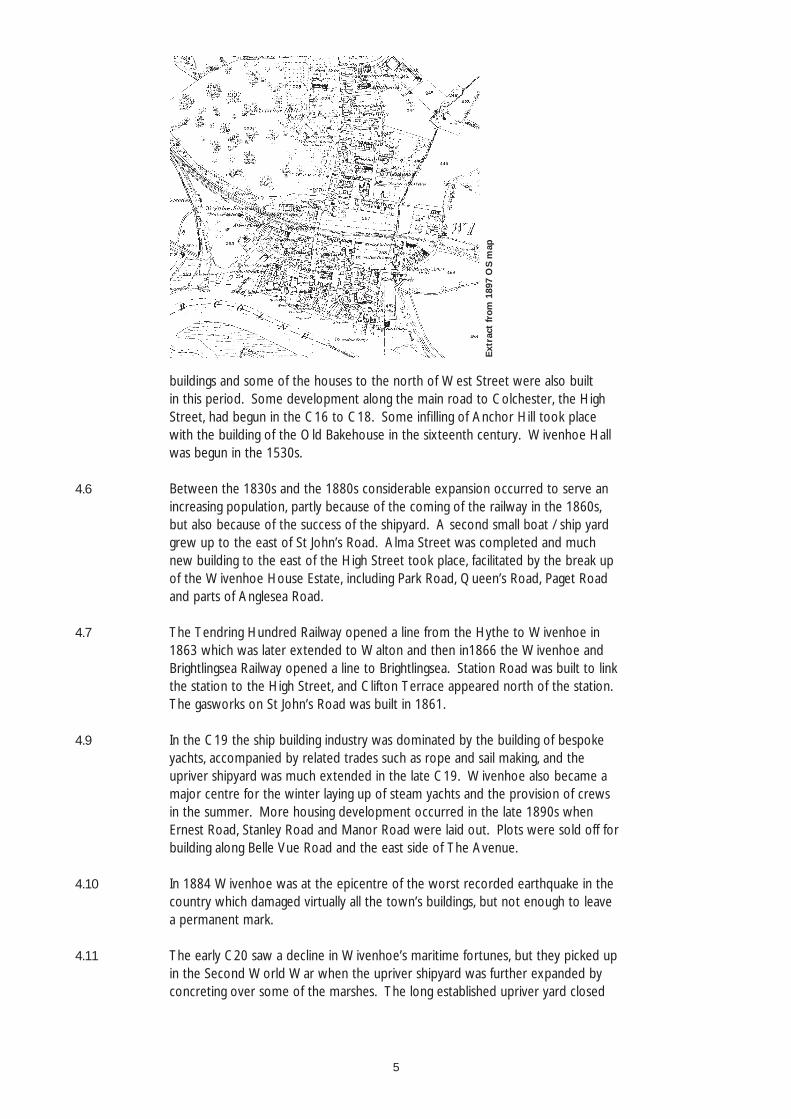
4.0 Brief History of the Area
4.1 The earliest reference to Wivenhoe is as `Wiunhov’ in the Domesday Book. The name is thought to come from `Wifa’s ridge’ deriving from its elevated position above the estuary. In 1086 it appears to have been only a small manorial village.
4.2 During the medieval period Wivenhoe appears to have remained small and was centred on the Quay area suggesting that, as later, the Colne Estuary was the basis of its economic activity. St Mary’s Church is of the C14 indicating some degree of wealth in the settlement. The Church and Churchyard appear to mark approximately the northern edge of the town at this point, with the southern boundary formed by the quay. The town seems to have been bordered by Bath Street to the west and by the houses in Brook Street and Bethany Street to the East.
4.3 The street plan is uncertain but is thought to have been similar to the post-medieval street plan, with fi ve blocks of buildings set at right angles to the quay. Anchor Hill was possibly intended as a market place, although there is no evidence for this, since High Street, West Street and East Street all run into it, and a lane leads from it to the Quay. The main road from Colchester (High Street) runs from north to south along the western edge of the churchyard and terminates at Anchor Hill. The manor house was to the North West, set apart from the rest of the town on the site later occupied by Wivenhoe Hall.
4.4 In the post-medieval period Wivenhoe appears to have grown slowly. Its estuarine position dominated the economic and industrial life of the town which served as a port for Colchester. Large ships coming up the Colne would offl oad into smaller lighters for Colchester Hythe. Farm produce from the Wivenhoe hinterland was exported to London and coal imported in exchange; the evidence for this is shown on C18 maps by the presence of coal yards and granaries for the storage of grain. Apart from the fi shing activity, the main industry in the area was shipbuilding in the yard to the west of Bath Street, evidence for which has been traced back to the C16. Oyster catching was also important; oysters were taken from the mouth of the river Colne and kept in special pits on the Quay before going to London, often via Colchester.
4.5 The fi ve blocks of buildings behind the quay contain C16 and C17 century
5
buildings and some of the houses to the north of West Street were also built in this period. Some development along the main road to Colchester, the High Street, had begun in the C16 to C18. Some infi lling of Anchor Hill took place with the building of the Old Bakehouse in the sixteenth century. Wivenhoe Hall was begun in the 1530s.
4.6 Between the 1830s and the 1880s considerable expansion occurred to serve an increasing population, partly because of the coming of the railway in the 1860s, but also because of the success of the shipyard. A second small boat / ship yard grew up to the east of St John’s Road. Alma Street was completed and much new building to the east of the High Street took place, facilitated by the break up of the Wivenhoe House Estate, including Park Road, Queen’s Road, Paget Road and parts of Anglesea Road.
4.7 The Tendring Hundred Railway opened a line from the Hythe to Wivenhoe in 1863 which was later extended to Walton and then in1866 the Wivenhoe and Brightlingsea Railway opened a line to Brightlingsea. Station Road was built to link the station to the High Street, and Clifton Terrace appeared north of the station. The gasworks on St John’s Road was built in 1861.
4.9 In the C19 the ship building industry was dominated by the building of bespoke yachts, accompanied by related trades such as rope and sail making, and the upriver shipyard was much extended in the late C19. Wivenhoe also became a major centre for the winter laying up of steam yachts and the provision of crews in the summer. More housing development occurred in the late 1890s when Ernest Road, Stanley Road and Manor Road were laid out. Plots were sold off for building along Belle Vue Road and the east side of The Avenue.
4.10 In 1884 Wivenhoe was at the epicentre of the worst recorded earthquake in the country which damaged virtually all the town’s buildings, but not enough to leave a permanent mark.
4.11 The early C20 saw a decline in Wivenhoe’s maritime fortunes, but they picked up in the Second World War when the upriver shipyard was further expanded by concreting over some of the marshes. The long established upriver yard closed
Ext
ract
from
189
7 O
S m
ap
6
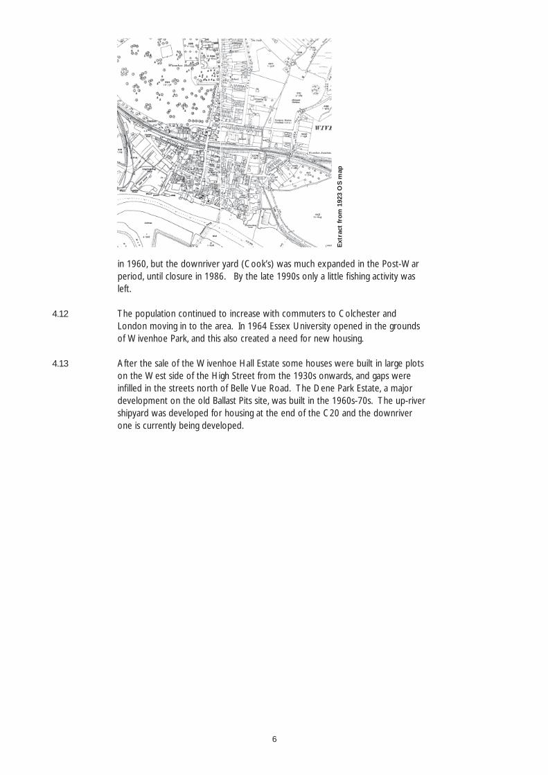
in 1960, but the downriver yard (Cook’s) was much expanded in the Post-War period, until closure in 1986. By the late 1990s only a little fi shing activity was left.
4.12 The population continued to increase with commuters to Colchester and London moving in to the area. In 1964 Essex University opened in the grounds of Wivenhoe Park, and this also created a need for new housing.
4.13 After the sale of the Wivenhoe Hall Estate some houses were built in large plots on the West side of the High Street from the 1930s onwards, and gaps were infi lled in the streets north of Belle Vue Road. The Dene Park Estate, a major development on the old Ballast Pits site, was built in the 1960s-70s. The up-river shipyard was developed for housing at the end of the C20 and the downriver one is currently being developed.
Ext
ract
from
192
3 O
S m
ap
7
5.0 Archaeology
5.1 No excavations have taken place in Wivenhoe (up to 1998), although a watching-brief is in place at the site of the Congregational Church (originally Wivenhoe Hall) where a 2.5 m deep pit was found with high oyster shell content. The fabric of St Mary’s Church contains Roman brick and tile but there is no other evidence of Roman activity in Wivenhoe.
5.2 Due to the very limited archaeological fi eldwork that has been undertaken, all medieval and post-medieval areas of Wivenhoe are of interest. Remnants of the medieval wharf may survive behind the existing quay and the waterfront has the potential for water-logged deposits.
5.3 The key surviving archaeological evidence for Wivenhoe’s past lies in the buildings and street pattern of the settlement. The original street pattern has survived including Anchor Hill and the quay which continues to be used as a small recreational port. The many historic buildings are of importance too, particularly the earliest examples which date from the C14-C17.
8
6.0 Setting
6.1 Wivenhoe is situated approximately three miles south-east of Colchester, on the east bank of the river Colne where it widens to form an estuary. From the river in the south and west of the parish, the land rises gradually to over 30 metres across much of the north and east. The parish is mainly glacial gravel and sand, with some glacial loam in the north-east and a small pocket in the north-west. A band of London clay is exposed along the Colne valley, and bands of alluvium extend alongside the river. There is an outcrop of sand and gravel on the site of the quay and early town.
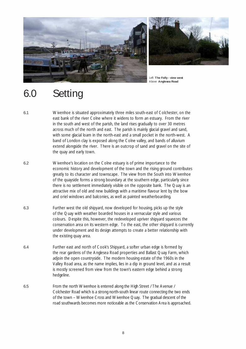
6.2 Wivenhoe’s location on the Colne estuary is of prime importance to the economic history and development of the town and the rising ground contributes greatly to its character and townscape. The view from the South into Wivenhoe of the quayside forms a strong boundary at the southern edge, particularly since there is no settlement immediately visible on the opposite bank. The Quay is an attractive mix of old and new buildings with a maritime fl avour lent by the bow and oriel windows and balconies, as well as painted weatherboarding.
6.3 Further west the old shipyard, now developed for housing, picks up the style of the Quay with weather boarded houses in a vernacular style and various colours. Despite this, however, the redeveloped upriver shipyard squeezes the conservation area on its western edge. To the east, the other shipyard is currently under development and its design attempts to create a better relationship with the existing quay area.
6.4 Further east and north of Cook’s Shipyard, a softer urban edge is formed by the rear gardens of the Anglesea Road properties and Ballast Quay Farm, which adjoin the open countryside. The modern housing estate of the 1960s in the Valley Road area, as the name implies, lies in a dip in ground level, and as a result is mostly screened from view from the town’s eastern edge behind a strong hedgeline.
6.5 From the north Wivenhoe is entered along the High Street / The Avenue / Colchester Road which is a strong north-south linear route connecting the two ends of the town – Wivenhoe Cross and Wivenhoe Quay. The gradual descent of the road southwards becomes more noticeable as the Conservation Area is approached.
Left The Folly - view westAbove Anglesea Road
9
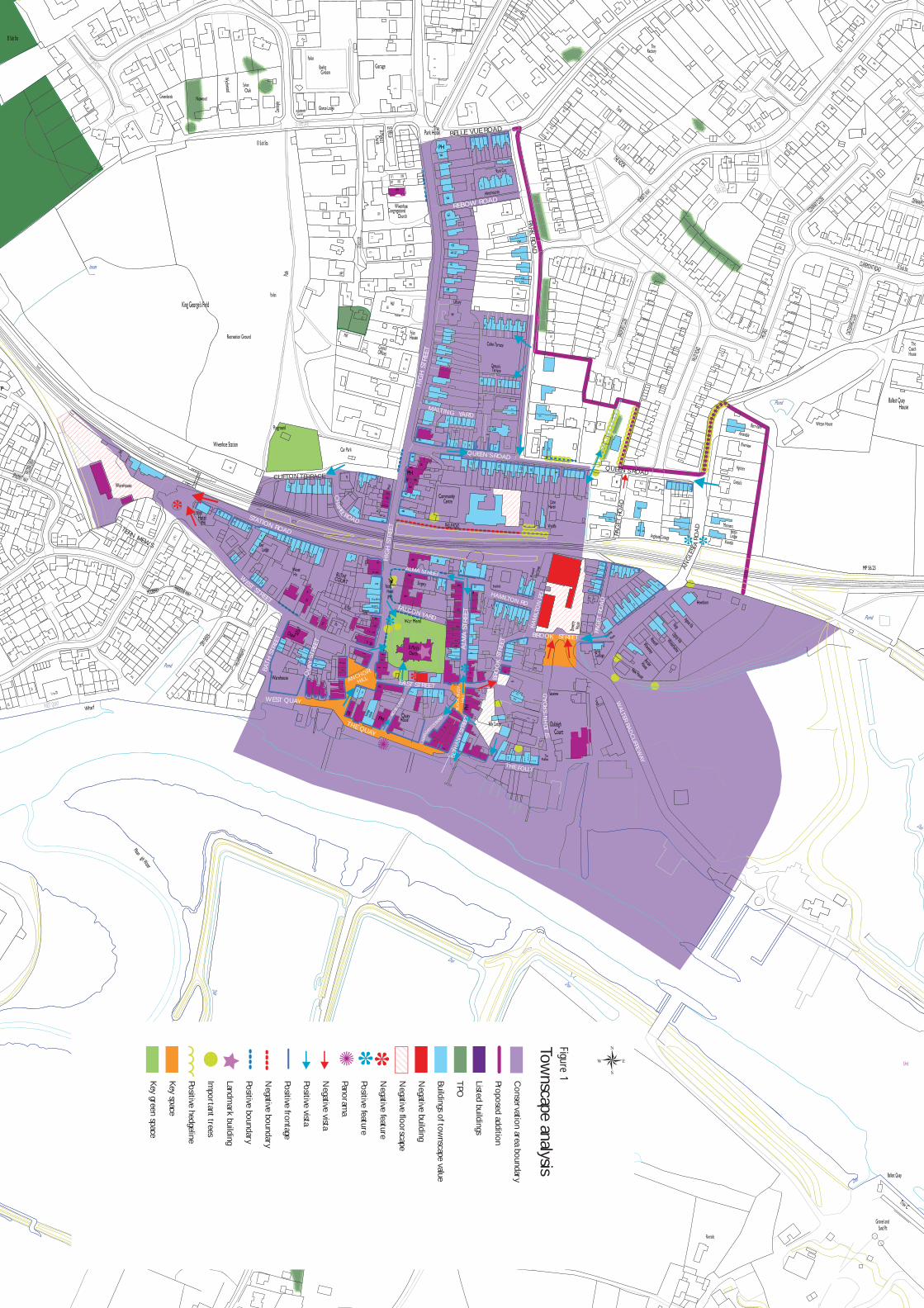
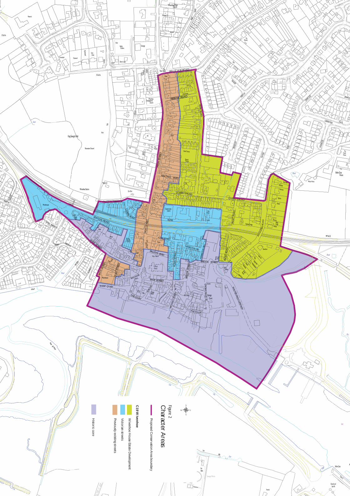
7.0 Townscape Analysis [See Fig.1]
7.0.1 The Conservation Area has been split up into two main character areas based on the visible built fabric – C19 Wivenhoe and the Historic Core. The C19 character area has then been divided up into three sub-areas based on their development history – the Wivenhoe House Estate development, Victorian streets, and previously existing streets which now predominantly consist of C19 properties. (See Fig.2)
A) C19 Wivenhoe i) The Wivenhoe House Estate development
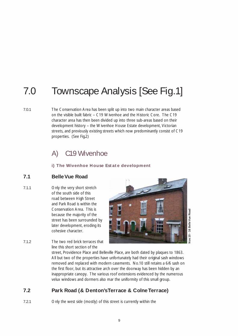
7.1 Belle Vue Road
7.1.1 Only the very short stretch of the south side of this road between High Street and Park Road is within the Conservation Area. This is because the majority of the street has been surrounded by later development, eroding its cohesive character.
7.1.2 The two red brick terraces that line this short section of the street, Providence Place and Belleville Place, are both dated by plaques to 1863. All but two of the properties have unfortunately had their original sash windows removed and replaced with modern casements. No.10 still retains a 6/6 sash on the fi rst fl oor, but its attractive arch over the doorway has been hidden by an inappropriate canopy. The various roof extensions evidenced by the numerous velux windows and dormers also mar the uniformity of this small group.
7.2 Park Road (& Denton’s Terrace & Colne Terrace)
7.2.1 Only the west side (mostly) of this street is currently within the
Nos
10
- 16
Bel
le V
ue R
oad
10
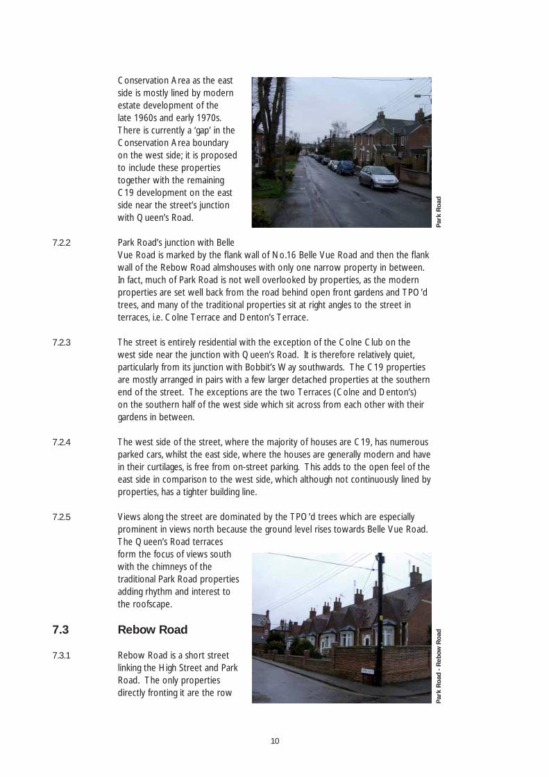
Conservation Area as the east side is mostly lined by modern estate development of the late 1960s and early 1970s. There is currently a ‘gap’ in the Conservation Area boundary on the west side; it is proposed to include these properties together with the remaining C19 development on the east side near the street’s junction with Queen’s Road.
7.2.2 Park Road’s junction with Belle Vue Road is marked by the fl ank wall of No.16 Belle Vue Road and then the fl ank wall of the Rebow Road almshouses with only one narrow property in between. In fact, much of Park Road is not well overlooked by properties, as the modern properties are set well back from the road behind open front gardens and TPO’d trees, and many of the traditional properties sit at right angles to the street in terraces, i.e. Colne Terrace and Denton’s Terrace.
7.2.3 The street is entirely residential with the exception of the Colne Club on the west side near the junction with Queen’s Road. It is therefore relatively quiet, particularly from its junction with Bobbit’s Way southwards. The C19 properties are mostly arranged in pairs with a few larger detached properties at the southern end of the street. The exceptions are the two Terraces (Colne and Denton’s) on the southern half of the west side which sit across from each other with their gardens in between.
7.2.4 The west side of the street, where the majority of houses are C19, has numerous parked cars, whilst the east side, where the houses are generally modern and have in their curtilages, is free from on-street parking. This adds to the open feel of the east side in comparison to the west side, which although not continuously lined by properties, has a tighter building line.
7.2.5 Views along the street are dominated by the TPO’d trees which are especially prominent in views north because the ground level rises towards Belle Vue Road. The Queen’s Road terraces form the focus of views south with the chimneys of the traditional Park Road properties adding rhythm and interest to the roofscape.
7.3 Rebow Road
7.3.1 Rebow Road is a short street linking the High Street and Park Road. The only properties directly fronting it are the row
Park
Roa
dPa
rk R
oad
- Reb
ow R
oad
11
of almshouses on the north side. These six almshouses were built after 1872 and were originally for single women or widows, preferably sailors’ widows. The houses were modernised in 1988 and now unfortunately have uPVC windows and doors, although the original stone openings remain together with the clay tile roof. They are attractively enclosed by a red brick boundary wall.
7.3.2 The south side of the road is lined by a timber-boarded fence which encloses the garden of No.49 Park Road, a modern property. The rear of No.128 High Street is prominent in views west along the street.
7.4 Queen’s Road
7.4.1 Queen’s Road is a long narrow street running east-west; it feels particularly narrow where it is enclosed by terraces on either side and is often tightly parked with cars. It dips signifi cantly towards The Pump House and rises again to join Anglesea Road at the eastern end. The street begins to open up east of the junction with Park Road as the continuity of the terraces is replaced by larger, often modern, detached houses with larger gardens.
7.4.2 The array of telegraph poles, electricity wires, etc. is very evident in views along the street, but particularly at the western end where the narrowness of the carriageway accentuates the criss-crossing of wires between properties. The change in ground level along the street also draws attention to the overhead wires.
7.4.3 Currently only the western half of the street is within the Conservation Area, excluding important buildings such as The Pump House and the other remaining terrace at the eastern end of the street. It is proposed to bring the entire length of Queen’s Road within the Conservation Area, with the exception of Valley Road properties which form the eastern end of the north side of Queen’s Road.
7.4.4 The 2 storey terraces tightly line the road at the western end, narrowing the street after the wide entrance with the High Street. There is a wide variety in the detailing between the terraces distinguishing the different build periods. Red brick and slate are the predominant and unifying building materials, although
Que
en’s
Roa
d - v
iew
eas
t ou
tsid
e N
o. 1
7Q
ueen
’s R
oad
-The
Pum
p H
ouse
12
some properties have been rendered or painted, and a number have replacement concrete tiled roofs. Many have replacement windows and doors, eroding the uniformity of the terraces even further.
7.4.5 The tiny front gardens of the terraces often have no boundary or only the remains of walls; a handful have railings. Two good red brick boundary walls line the northern side of the street. One encloses the garden of No.23 which has a grand garden front, belying its modest street frontage. The other encloses the garden of The Pump House which has a verdant setting nestled between strong hedgelines and with the Brook running alongside it. Views west from The Pump House, are across the gardens of the properties on the north side of the road towards the rear of the large houses on Park Road.
7.5 Paget Road
7.5.1 Paget Road is split by the railway which is crossed by a footway across the tracks, linking the two halves for pedestrians, but not for vehicles. As this residential road is effectively two dead-ends, it is very quiet and each half has its own character; the northern half is much more open and contains more modern properties, whilst the south is older and tightly enclosed.
7.5.2 The southern half predominantly dates from the second half of the C19 (e.g. Nos. 1&3 Willie Cottage, 1877) and is defi ned by its two red brick terraces and the rear of the Anglesea Road terrace. Only the west side is fronted by properties, including No.5 with its attractive margin-paned sashes; the east side is lined by the rear boundaries of the even-numbered terrace that actually fronts the railway. Paget Road’s entrance from Brook Street is defi ned by the good garden wall of Broadway House.
7.5.3 Both sides of the road have an unadopted carriageway, but the northern half of Paget Road, unlike the tarmac surface of the southern half, has a loose gravel surface. This, together with the more open nature of the road and the detached dwellings, creates an informal, almost rural, feel, compared to the much more urban terraced character of the southern half.
Page
t R
oad
(sou
th)
Page
t R
oad
(nor
th)
13
7.6 Anglesea Road
7.6.1 Anglesea Road, like Paget Road, is also split by the railway, albeit this time by a bridge which allows free vehicular and pedestrian movement between the two halves. This has the negative effect of making it relatively busy with traffi c, and this will increase as the Cook’s Shipyard development is completed because Anglesea Road forms the main route in and out of Wivenhoe for the development’s inhabitants.
7.6.2 The road is unadopted and the loose gravel surface unifi es the street, the character of which is still divided by the railway, although not as signifi cantly as Paget Road. The northern half is currently outside the Conservation Area, but it is proposed to bring it within the boundary to unify the street. The northern half is an important link from the open countryside which it adjoins, and this rural feel is continued by the hedgeline that lines the northwest side of the road (little more than a lane at this point), screening the modern development behind.
7.6.3 The land falls southwards, levelling out briefl y at the railway bridge before descending quite steeply again. Views towards The Quay and the River Colne are glimpsed from the southern end of the road, although the redevelopment of Cook’s Shipyard will block these. Overhead wires are particularly noticeable at the southern end of the street and in views north up the street.
7.6.4 A maritime connection is imparted by the buoys that sit either side of the railway bridge and the names of many of the houses, e.g. Mariners, Riverview, etc. The road is entirely residential with a series of detached and semi-detached properties of varying ages lining the northern half and the southeastern side of the southern half. There are a number of C19 villas in between the modern detached properties, but these have unfortunately been subject to extensions and alterations of variable quality over the years. Berri-dene and Annandale are particularly prominent sitting at the top of the hill and are visible from several points within the Conservation Area.
7.6.5 The road kinks southwest after the railway bridge, and the ground level falls more steeply towards the road’s junction with Brook Street. This kink in the road focuses views south on Hewthorn, a substantial detached C19 villa which retains its multi-paned sash windows. The northwestern side of the south half of the road is enclosed by a terrace of 2 storey red brick and slate roofed properties with the notable Broadway House forming an attractive end-point to the street and leading the eye to Spring Cottage and onwards to Brook Street.
Ang
lese
a R
oad
14
ii) Victorian Streets
7.7 Hamilton Road
7.7.1 Hamilton Road is a very quiet L-shaped residential road which connects Brook Street and Alma Street. It is almost entirely comprised of terraced properties, although the Business Centre forms the eastern side of the north-west leg. It is another unadopted road, and has a loose gravel surface in common with most other unadopted highways in the town.
7.7.2 In contrast to the red brick that is usually found in the town, Nos. 1-6 are of gault brick with stone detailing, and have ground fl oor bay windows. The other properties in the street are the more typical red brick, although Hope Cottage has a rendered front elevation. No.9 is a new detached property, but has been designed to refl ect the traditional properties it adjoins, although it lacks certain details such as a chimney.
7.7.3 The land rises to the west along the east-west leg of the street with views west focusing on the rear of No.30 Alma Street, at which point a small dog-leg turn in Hamilton Road leads onto the northern end of Alma Street. No.1 Brook Street forms the focus of views south, whilst views north and east are dominated by the unattractive buildings of the Business Centre.
7.8 Alma Street
7.8.1 Another ‘L-shaped’ street, Alma Street is tightly enclosed by terraces on either side which channels views up and down the street. The 3 storey Alma House (the former Swedenborg Chapel) forms the focus of views north. The street runs north from the junction of East and Brook Streets, turning west at an angle of a little more than 90 degrees to join up with the High Street. This east-west section is approximately parallel with the railway line to the north and Falcon Yard to the south. The extension of Alma Street to the east becomes Hamilton Road. The two different sections have rather different characters; the north/south section consists largely
Ham
ilton
Roa
dA
lma
Stre
et
15
of red brick houses in a polite architectural style right up to the street edge. The western section has a different character; although it does have some brick houses right up to the road edge, it is also bounded by walls, the backs of buildings and breaks between buildings. The street was built between1840 and1860.
7.8.2 Entering Alma Street from the southern end there is a sense of constriction and enclosure, as the corner buildings (on the corners with East Street and Brook Street) are taller than the terraces forming this part of the street. Apart from a couple of breaks in the line of houses at the southern end, the terraces are of similar height and draw the eye along the street to Alma House which appears to enclose the street at the end. This building is of a similar height to No. 30 which turns the corner into Hamilton Road. A sense of homogeneity is created by the fact that it is also red brick, but is of three storeys with a steeply pointed gable and arched windows on the second and third fl oors. The terraces along the east and west sides vary, with two, three or four buildings built in the same style, but all looking similar because of the brick construction, similar sash windows, slate roofs and being built right up to the street edge. Some are grander with Egyptian style door cases with pilasters, some are rather taller than others, No.2 is painted blue, some are in gault brick, and not all retain their original windows, but the overall effect is of unity enlivened with some variation.
7.8.3 At the corner where the street turns to the west, the view to the south also presents a sense of enclosure, as the street seems to be closed off at the southern end as one looks slightly down hill, by the building on the corner of Hardings Yard and Black Buoy Hill. The sense of enclosure and narrowness is enhanced by the fact that the houses are built right up to the edge of the road. Some have a few paving stones as a sort of threshold and Nos. 6 & 8 have brightly coloured original tiles. A couple have a low wall to separate them from the street.
7.8.4 The western section to the High Street takes on a different character as the corner is turned. This section is still very narrow but is much less homogenous. There is still a sense of enclosure as a number of buildings are built right up to the street edge, and there are some red brick houses, but there are also the backs of houses on neighbouring streets and a number of gaps in the building line. Some of the brickwork is painted white, and No. 38 on the north side is rendered and painted pink. This building is set well back from the road and is glimpsed through the foliage above a high brick wall. The view along to the west is closed by another red brick building on the High Street.
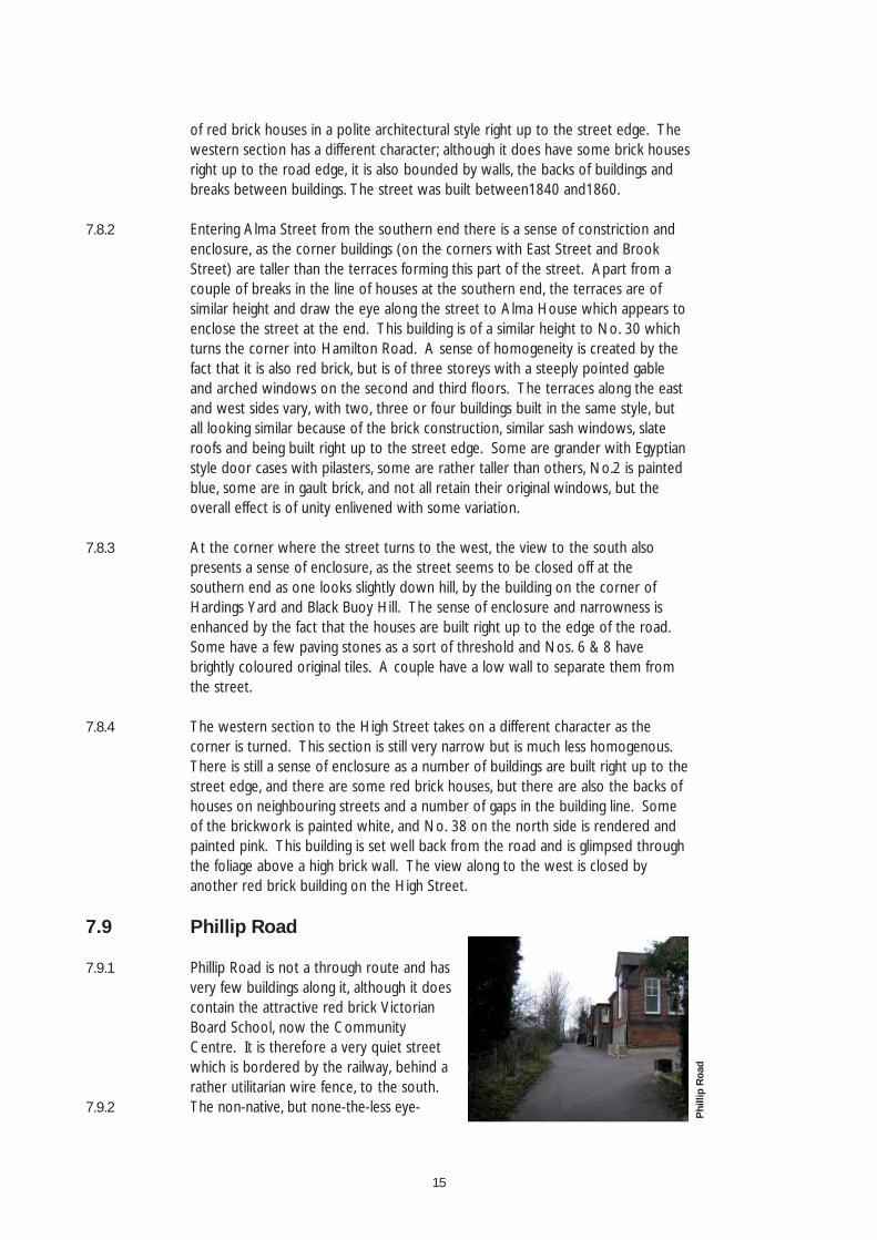
7.9 Phillip Road
7.9.1 Phillip Road is not a through route and has very few buildings along it, although it does contain the attractive red brick Victorian Board School, now the Community Centre. It is therefore a very quiet street which is bordered by the railway, behind a rather utilitarian wire fence, to the south.
7.9.2 The non-native, but none-the-less eye-
Phi
llip
Roa
d
16
catching, gum tree at the street’s eastern end is the focus of views east, whilst a view of the Church tower and cupola is gained looking south across the railway. At the western end, the attractive fl ank elevation of No.48 High Street sits at the back of the highway, although the eye is drawn to the rather incongruous elevation of No.45-47 High Street on the other side.
7.9.3 The key building is the attractively detailed School with its decorative brickwork and gabled elevations. Aside from No.48 High Street, the only other traditional building is Wycliffe, a small turn of the C19/C20 painted property which is almost hidden behind the vegetation at the eastern end of the street.
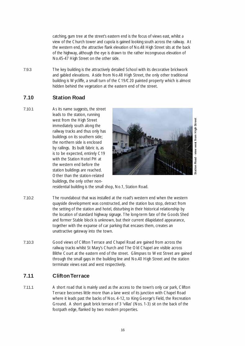
7.10 Station Road
7.10.1 As its name suggests, the street leads to the station, running west from the High Street immediately south along the railway tracks and thus only has buildings on its southern side; the northern side is enclosed by railings. Its built fabric is, as is to be expected, entirely C19 with the Station Hotel PH at the western end before the station buildings are reached. Other than the station-related buildings, the only other non-residential building is the small shop, No.1, Station Road.
7.10.2 The roundabout that was installed at the road’s western end when the western quayside development was constructed, and the station bus stop, detract from the setting of the station and hotel, disturbing in their historical relationship by the location of standard highway signage. The long-term fate of the Goods Shed and former Stable block is unknown, but their current dilapidated appearance, together with the expanse of car parking that encases them, creates an unattractive gateway into the town.
7.10.3 Good views of Clifton Terrace and Chapel Road are gained from across the railway tracks whilst St Mary’s Church and The Old Chapel are visible across Blithe Court at the eastern end of the street. Glimpses to West Street are gained through the small gaps in the building line and No.40 High Street and the station terminate views east and west respectively.
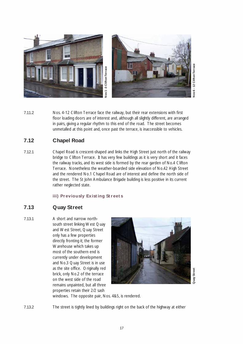
7.11 Clifton Terrace
7.11.1 A short road that is mainly used as the access to the town’s only car park, Clifton Terrace becomes little more than a lane west of its junction with Chapel Road where it leads past the backs of Nos. 4-12, to King George’s Field, the Recreation Ground. A short gault brick terrace of 3 ‘villas’ (Nos. 1-3) sit on the back of the footpath edge, fl anked by two modern properties.
Stat
ion
Roa
d - v
iew
wes
t fr
om H
igh
Stre
et
17
7.11.2 Nos. 4-12 Clifton Terrace face the railway, but their rear extensions with fi rst fl oor loading doors are of interest and, although all slightly different, are arranged in pairs, giving a regular rhythm to this end of the road. The street becomes unmetalled at this point and, once past the terrace, is inaccessible to vehicles.
7.12 Chapel Road
7.12.1 Chapel Road is crescent-shaped and links the High Street just north of the railway bridge to Clifton Terrace. It has very few buildings as it is very short and it faces the railway tracks, and its west side is formed by the rear garden of No.4 Clifton Terrace. Nonetheless the weather-boarded side elevation of No.42 High Street and the rendered No.1 Chapel Road are of interest and defi ne the north side of the street. The St John Ambulance Brigade building is less positive in its current rather neglected state.
iii) Previously Existing Streets
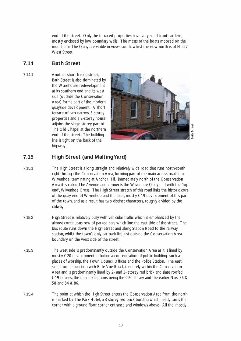
7.13 Quay Street
7.13.1 A short and narrow north-south street linking West Quay and West Street, Quay Street only has a few properties directly fronting it; the former Warehouse which takes up most of the southern end is currently under development and No.3 Quay Street is in use as the site offi ce. Originally red brick, only No.2 of the terrace on the west side of the road remains unpainted, but all three properties retain their 2/2 sash windows. The opposite pair, Nos. 4&5, is rendered.
7.13.2 The street is tightly lined by buildings right on the back of the highway at either
Nos
1 -3
Clif
ton
Terr
ace
Nos
6 -
12 C
lifto
n Te
rrac
eQ
uay
Stre
et
18
end of the street. Only the terraced properties have very small front gardens, mostly enclosed by low boundary walls. The masts of the boats moored on the mudfl ats in The Quay are visible in views south, whilst the view north is of No.27 West Street.
7.14 Bath Street
7.14.1 Another short linking street, Bath Street is also dominated by the Warehouse redevelopment at its southern end and its west side (outside the Conservation Area) forms part of the modern quayside development. A short terrace of two narrow 3-storey properties and a 2-storey house adjoins the single storey part of The Old Chapel at the northern end of the street. The building line is tight on the back of the highway.
7.15 High Street (and Malting Yard)
7.15.1 The High Street is a long, straight and relatively wide road that runs north-south right through the Conservation Area, forming part of the main access road into Wivenhoe, terminating at Anchor Hill. Immediately north of the Conservation Area it is called The Avenue and connects the Wivenhoe Quay end with the ‘top end’, Wivenhoe Cross. The High Street stretch of this road links the historic core of the quay end of Wivenhoe and the later, mostly C19 development of this part of the town, and as a result has two distinct characters, roughly divided by the railway.
7.15.2 High Street is relatively busy with vehicular traffi c which is emphasized by the almost continuous row of parked cars which line the east side of the street. The bus route runs down the High Street and along Station Road to the railway station, whilst the town’s only car park lies just outside the Conservation Area boundary on the west side of the street.
7.15.3 The west side is predominantly outside the Conservation Area as it is lined by mostly C20 development including a concentration of public buildings such as places of worship, the Town Council Offi ces and the Police Station. The east side, from its junction with Belle Vue Road, is entirely within the Conservation Area and is predominantly lined by 2- and 3- storey red brick and slate roofed C19 houses, the main exceptions being the C20 library and the earlier Nos. 56 & 58 and 84 & 86.
7.15.4 The point at which the High Street enters the Conservation Area from the north is marked by The Park Hotel, a 3 storey red brick building which neatly turns the corner with a ground fl oor corner entrance and windows above. All the, mostly
Bat
h St
reet
19
residential, properties are set back from the road behind small front gardens which are generally enclosed by low walls, sometimes with railings.
7.15.5 The relatively consistent use of red brick and slate roof is enlivened by the use of bay windows, gault brick and stone detailing, hipped and parapetted roofs, ornate door cases and decorative timber-work such as barge boards. The occasional gable-end on property adds interest to the townscape, and usually fl anks the junction with another street, e.g. Queens Road and Phillip Road. A few properties have later been painted or rendered and re-roofed with concrete tiles. Some have also unfortunately replaced the original sashes that survive in many properties with uPVC or timber casement windows.
7.15.6 Travelling south along the High Street, the land falls gradually, levelling out slightly by the bridge over the railway before descending again towards its termination at Anchor Hill in the historic core of the town. The almost continuous slightly set-back building line emphasises the change in level, with the rooftops and chimneys of the properties stepping up the hill in views north.
7.15.7 The consistent built frontage is interrupted by the library which is set further back than the traditional properties and is only single storey and of contrasting modern materials. The only major gap in the building line, however, is at the bridge over the railway. Malting Yard, a traditional red brick terrace of 7 properties (now mostly altered), is accessed between Nos. 74 & 76 High Street.
7.15.8 South from the High Street’s junction with Clifton Terrace, just north of the railway, both sides of the street are within the Conservation Area. From this point on, the High Street is predominantly lined by listed buildings and St Mary’s Church becomes visible, indicating that the historic core of the town is being entered.
7.15.9 South of the railway, red brick and polite architecture gives way to timber-framing and plaster, render and weatherboarding, i.e. vernacular construction, although brick is still in evidence. The street takes on a more commercial aspect at this
Park
Hot
el, H
igh
Stre
etN
os 1
08 -1
20 H
igh
Stre
et
20
point, with shops taking over from the residential properties found along the northern stretch of the street.
7.15.10 Although the fi rst couple of buildings on the east side of the street south of the railway are set well back, their boundary walls enclose the street well, complementing the buildings on the west side which are set hard on the back of the footway. The street opens up after No.36 at St Mary’s Church, the churchyard of which is bordered by good railings and gates before being ‘pinched in’ again by Nos. 2-8 (evens) and 1-5 (odds), after which Anchor Hill is reached.
B) Historic Core
7.16 Anchor Hill
7.16.1 Anchor Hill is one of the key spaces in the area as it is the termination of the High Street and is almost an ante-room to The Quay. Descending into Anchor Hill from the High Street, a sense of arriving at the heart of the town is felt, heightened by the proximity of St Mary’s Church, the tower of which looms above Nos. 2-4 High Street in the north-east corner of Anchor Hill.
7.16.2 The space is attractively enclosed by a variety of buildings, most of which are listed. The commercial nature of the High Street continues down the east side of Anchor Hill, whilst the entrance to The Quay is fl anked by dwellings.
7.16.3 The area is simply laid to tarmac with stretches of double yellow lines stopping the space becoming full of parked cars. Although some cars are parked here, Anchor Hill is not dominated by the vehicles and is relatively pedestrian-friendly, although there is vehicular access through the space onto The Quay.
7.16.4 The tall gable ends of the gault brick 3-storey Nos. 2&4 contrast with the vernacular 2-storey Nos. 1&3, and frame the view south to The Quay and the River Colne. Nos. 5-9 introduce red brick and slate into the palette of building materials, whilst the gable end of No.1 High Street has a weather-boarded fi rst fl oor. All the properties have sash windows.
7.17 West Quay, The Quay (incl. Colne Marine Row & Hardings Yard) & The Folly
7.17.1 The quay area is the focus of the town and the destination for most visitors. It is, as a result, particularly in the summer months, busy with pedestrians. Although its port function is now virtually redundant, it still retains a working feel with the
Anc
hor
Hill
21
numerous boats moored on the mudfl ats lining the quay. Wide views through the boat masts and rigs are gained across and along the River Colne over to the surrounding countryside.
7.17.2 A secluded feel at the eastern (The Folly) end is imparted by the numerous private jetties and is heightened by the unmetalled road surface that runs along the whole length of the quay area. Residential uses give way to more public activities further west and the hub of activity is centred on the Rose and Crown PH with the Nottage Institute containing a maritime museum next door.
7.17.3 The quay area is lined by a number of fi ne buildings which have been the subject of numerous paintings and pictures over the years. This picturesque waterfront setting is best seen from the south bank of the River Colne, from where St Mary’s Church with its distinctive cupola can be seen rising above the rooftops.
7.17.4 Of particular note, are the pretty Regency bow windows of Maple, Trinity and Quayside Cottages and the adjacent Anchor House on West Quay. The Colne Marine Row and Hardings Yard mews properties were originally the premises of the Colne Marine and Yacht Company. This stretch of the quay still fl oods at high tide despite the construction of the Colne Barrier. The Folly further east is a range of early C19 peg-tiled brick houses.
7.18 St John’s Street
7.18.1 Formerly the site of the gasworks, St John’s Road betrays little evidence of its early C19 origins and has been subject to almost complete redevelopment; its eastern side now forming part of the Cook’s Shipyard development. The building line on the west side is fragmented and all the properties are quite recent. A small ‘square’ is to be formed at its junction with Brook Street as part of the new development.
The
Qua
y
The
Fol
ly -
view
to
Bet
hany
Str
eet
St
John
’s St
reet
22
7.19 Brook Street
7.19.1 A dog-leg street that will connect two key spaces once the St John’s Road ‘square’ is completed, although the Business Centre is likely to detract from the setting of this space. Brook Street terminates at Black Buoy Hill which is a key space at the junction of several streets. It is a mixed use street with, in addition to the Business Centre, a few businesses scattered amongst the dwellings. Although it has a fragmented building line, a good sense of enclosure is maintained along most of the street by boundary walls.
7.19.2 Brook Street is a tight, intimate street with no pavements and not quite wide enough to allow two cars to pass. Despite this, it is relatively well used by vehicles, particularly at its eastern end with construction vehicles accessing the development site and business vehicles travelling to the Business Centre. Further west, the number of vehicles travelling along the street reduces, and the road becomes more pedestrian-friendly.
7.19.3 The street opens out at the bend by Corner Cottage, opposite which there are attractive views past Nos. 11&12, a C19 pair of cottages, to Folly Cottage and beyond to the cut which leads down to The Folly and the quay area. Less positively, the entrance to the Black Buoy PH car park and the forecourt of No.10 are open areas of tarmac with parked cars, the latter forming the focus of views from Black Buoy Hill.
7.19.4 The bends in the road mean that the backs of the Hamilton Road and Alma Street terraces are quite prominent in views north and west, with the Church tower visible above the Alma Street properties. A variety of building types and materials are found along the street including a C19 red brick and slate roofed terrace, and timber-framed and clay tile roofed dwellings. All, however, sit on the back of the highway or are set back slightly behind very small gardens.
7.20 Black Buoy Hill & Bethany Street
7.20.1 Black Buoy Hill is enclosed by an attractive group of buildings, displaying a wide variety of building materials and styles. Perhaps the most eye-catching is the painted Nos. 2-4 Alma Street which has a corner entrance to the space, whilst on the southern side, the eye is drawn to Black Buoy Cottage, which was known as Flat Iron cottage because of its distinctive shape, visible from Bethany Street.
7.20.2 Good views along Alma Street and East Street are gained from the space, and, adjacent to Black Buoy Cottage, views south through Hardings Yard to the River
Nos
5 -9
Bro
ok S
tree
t
23
Colne and quay area are glimpsed. Looking north before entering Bethany Street, The Corner House’s grand front is the focus of views, whilst to the south the curve of Black Buoy Cottage draws the eye towards Price’s House on Bethany Street.
7.20.3 Bethany Street is tightly enclosed on both sides by buildings, channelling views south to the River Colne, with views north terminated by the Black Buoy PH. It is a very quiet street with vehicular traffi c mostly confi ned to vehicles accessing the Black Buoy PH’s car park, the entrance of which is adjacent to Price’s House.
7.21 Rose Lane
7.21.1 Rose Lane is one of the short north-south connecting streets that link the Quay area to the roads running parallel to the north. In this instance, Rose Lane links The Quay, adjacent to the Rose and Crown PH, to East Street, which it joins adjacent to The Old Garrison House. Views north are of the south side of St Mary’s Church, although unfortunately the fl ue of the fi sh and chip shop catches the eye more.
7.21.2 Rose Lane is mostly enclosed by the boundary and fl ank walls of properties fronting The Quay or East Street. Its only property is No.2, a black-painted brick house with a hipped clay tile roof.
7.22 East Street
7.22.1 East Street, as its name indicates, runs east from the town’s main ‘square’ Anchor Hill, and terminates at Black Buoy Hill, another key space. The C17 Old Garrison House is a key building along the street; its grounds originally ran all the way down to the River Colne. Opposite, a good view of St Mary’s Church is marred by the fi sh and chip shop and parking area.
7.22.2 The eastern end of this narrow street is defi ned by various C19 developments, mostly of red brick, although The Corner House is of gault brick and Nonesuch House is C17 behind its later frontage. The Butchers on the corner of Brook
Bla
ck B
uoy
Hill
R
ose
Lane
24
Street partly blocks views east to Black Buoy Hill.
7.23 West Street
7.23.1 West Street is the longest of the streets within the Historic Core, connecting the High Street just north of Anchor Hill with the station where it meets Station Road at the roundabout. West of Bath Street and The Old Chapel, the south side of the street is outside the Conservation Area as this stretch of the street forms part of the modern quayside development.
7.23.2 The cupola and tower of St Mary’s Church is visible in views east along much of the street with an excellent view of the whole tower appearing as the High Street is reached. The slight curve in the street together with the tight building line means that only part of the street is visible at any time in views east and west with different buildings becoming important at varying points. The Old Chapel for example is prominent in views east from the station end of the street, whilst No.38 (outside the Conservation Area) is the focus of views from the High Street end.
7.23.3 The oldest buildings are, not surprisingly, found along the eastern half of the street and are a variety of C18 and C19 properties, two of the largest being West House and No.23. These are, unusually, set back from the street behind gardens enclosed by good red brick walls. At the rear of No.5 High Street, a small cut allows access to, and glimpses of, Anchor Hill.
7.23.4 Towards the station end of the street, the buildings are predominantly C19 and the building line is more fragmented, allowing views to the rear of the Station Road properties. Weather-boarding is not particularly common as a principal building material in Wivenhoe, but Nos. 5-9 are a short terrace of three weather-boarded properties on the back of the highway. Moving west, these are followed, after a gap, by a semi-detached pair of red brick properties more typical of Wivenhoe’s C19 development.
Old
Gar
riso
n H
ouse
- E
ast
Stre
et
25
8.0 Key Characteristics
8.1 Spaces
8.1.1 The quay area is the hub of activity in Wivenhoe, particularly in summer months, when the town is especially busy with visitors. It is a picturesque linear space that is pivotal to the town’s historical development. Immediately behind the quay, is Anchor Hill which is effectively the town’s ‘square’. This key space is attractively enclosed by a variety of buildings and is a more formal space than the quay which retains a slight industrial character and has an unmetalled surface. Anchor Hill in contrast has a tarmac surface which could be improved upon.
8.1.2 Black Buoy Hill is the only other ‘urban’ space in the town and is important because it is at the junction of several streets, including East Street which links it to Anchor Hill. Black Buoy Hill is also connected to the quay area via Hardings Yard and Bethany Street.
8.1.3 The only green space within the Conservation Area is St Mary’s churchyard which is only really visible from the High Street and glimpsed from East Street. It relieves the tight building line of the High Street, opening the street up by Falcon Yard. The only other green space that impacts on the Conservation Area is the playground just outside the boundary on Clifton Terrace. The lack of green space is, however, compensated for, by the quay and River Colne, and its absence is not a negative feature.
The
Qua
y A
ncho
r H
ill
Bla
ck B
uoy
Hill
26
8.1.4 Street trees and other street vegetation is not a feature of Wivenhoe either. Greenery in streets is provided by the occasional large tree within the garden of a property or vegetation overhanging garden walls. The greatest concentration of trees and shrubs is along the railway tracks.
8.2 Views
8.2.1 St Mary’s Church is the landmark building in the town with its tower and cupola visible from most parts of the Conservation Area. It is particularly prominent in views north from across the River Colne and from the High Street.
8.2.2 The raised ground within Wivenhoe contributes greatly to its character, allowing views that add considerable interest to the townscape. The changing ground level is particularly noticeable in the Queen’s Road and Park Road area where wide vistas across the streets are gained. Views down to the estuary are slightly limited because of the irregular layout of streets in the older parts of the town, but are important none-the-less in maintaining the link with the River.
8.3 Character areas
8.3.1 There is a distinct difference in character between the C19 streets and the surviving medieval streets. The C19 development can then be separated further into three sub-areas, but generally, those streets which consist mainly of C19 development are straighter and as a result are much more formal. The medieval streets have an irregular pattern and older buildings refl ecting the origins of the town.
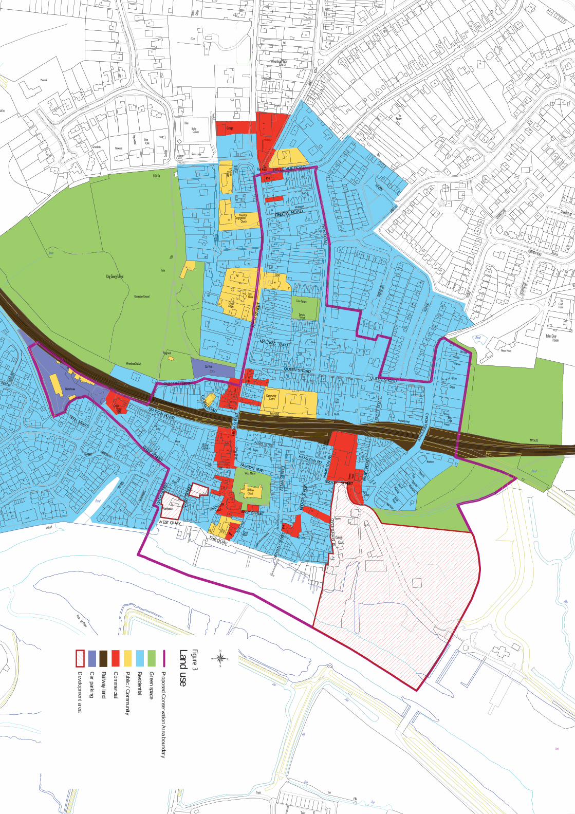
8.4 Uses [See Fig.3]
8.4.1 Wivenhoe has become predominantly more residential in nature with the decline of traditional maritime activities, and the closure and subsequent residential redevelopment of the town’s two shipyards. With the decline of these traditional industries and the loss of the workers, many of the town’s public houses, shops and other ancillary services disappeared. The former uses of many properties are, however, evident in surviving features or the names of buildings.
8.4.2 There is a small, but important and thriving, commercial core along the southern end of the High Street and Anchor Hill, ending at The Quay where a museum and public house form the focus of activities. Most of the town’s public and community buildings lie outside the Conservation Area on the west side of the High Street north of the railway line.
Nos
21
- 25
Hig
h St
reet
27
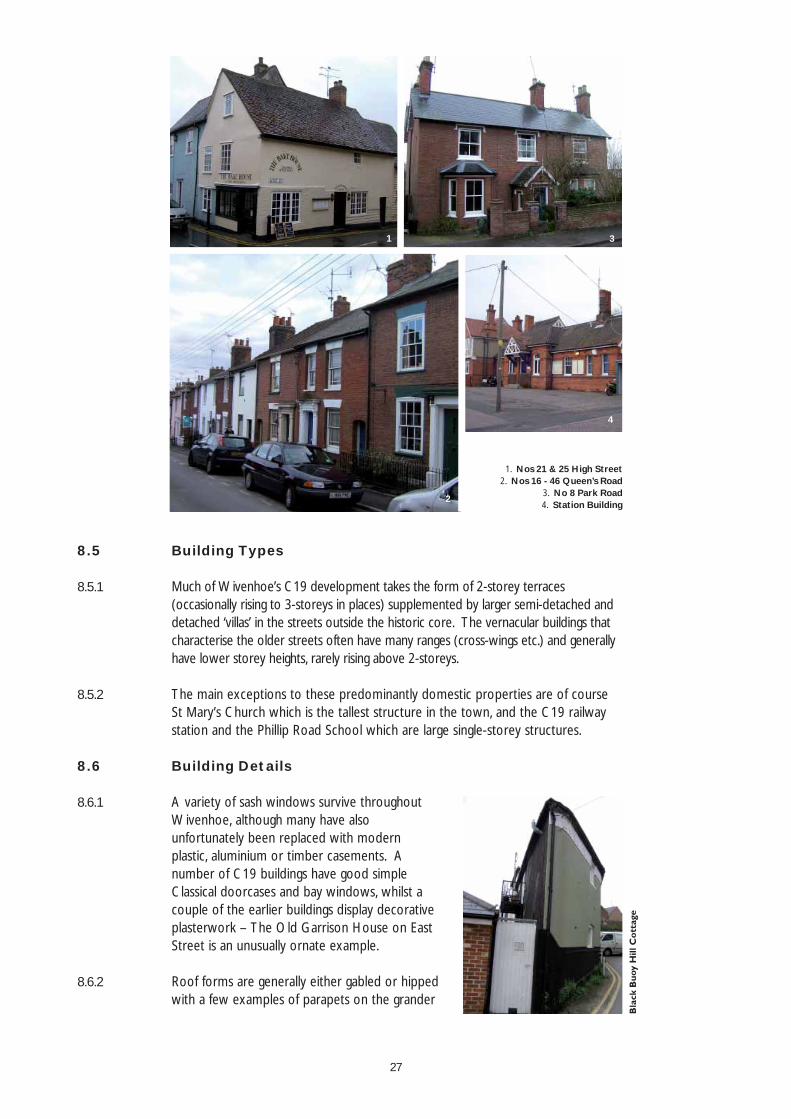
8.5 Building Types
8.5.1 Much of Wivenhoe’s C19 development takes the form of 2-storey terraces (occasionally rising to 3-storeys in places) supplemented by larger semi-detached and detached ‘villas’ in the streets outside the historic core. The vernacular buildings that characterise the older streets often have many ranges (cross-wings etc.) and generally have lower storey heights, rarely rising above 2-storeys.
8.5.2 The main exceptions to these predominantly domestic properties are of course St Mary’s Church which is the tallest structure in the town, and the C19 railway station and the Phillip Road School which are large single-storey structures.
8.6 Building Details
8.6.1 A variety of sash windows survive throughout Wivenhoe, although many have also unfortunately been replaced with modern plastic, aluminium or timber casements. A number of C19 buildings have good simple Classical doorcases and bay windows, whilst a couple of the earlier buildings display decorative plasterwork – The Old Garrison House on East Street is an unusually ornate example.
8.6.2 Roof forms are generally either gabled or hipped with a few examples of parapets on the grander
1 3
2
4
1. Nos 21 & 25 High Street 2. Nos 16 - 46 Queen’s Road
3. No 8 Park Road4. Station Building
28
properties. Some properties are gable-end onto the street, but the majority within the historic core are parallel to the street and set right on the back of the highway. A number of good traditional shopfronts survive on existing commercial premises; those that are now redundant provide a clue to the building’s former use and thus the history of the town.
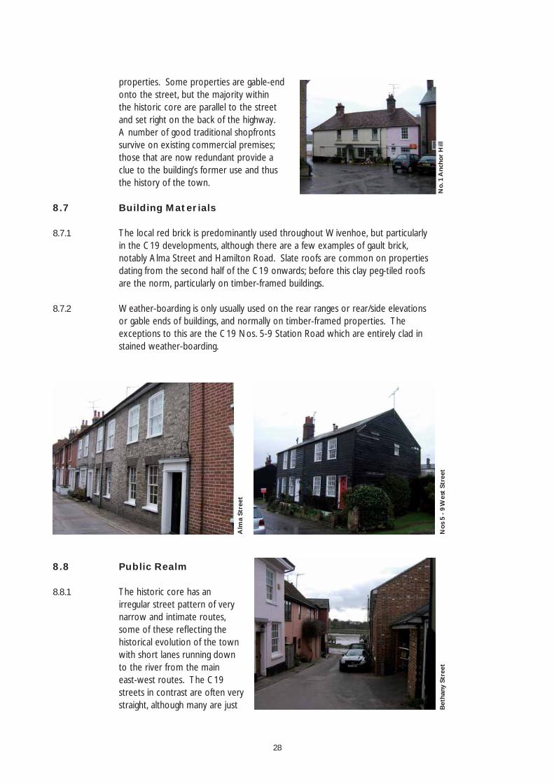
8.7 Building Materials
8.7.1 The local red brick is predominantly used throughout Wivenhoe, but particularly in the C19 developments, although there are a few examples of gault brick, notably Alma Street and Hamilton Road. Slate roofs are common on properties dating from the second half of the C19 onwards; before this clay peg-tiled roofs are the norm, particularly on timber-framed buildings.
8.7.2 Weather-boarding is only usually used on the rear ranges or rear/side elevations or gable ends of buildings, and normally on timber-framed properties. The exceptions to this are the C19 Nos. 5-9 Station Road which are entirely clad in stained weather-boarding.
No.
1 A
ncho
r H
ill
Alm
a St
reet
Nos
5 -
9 W
est
Stre
et
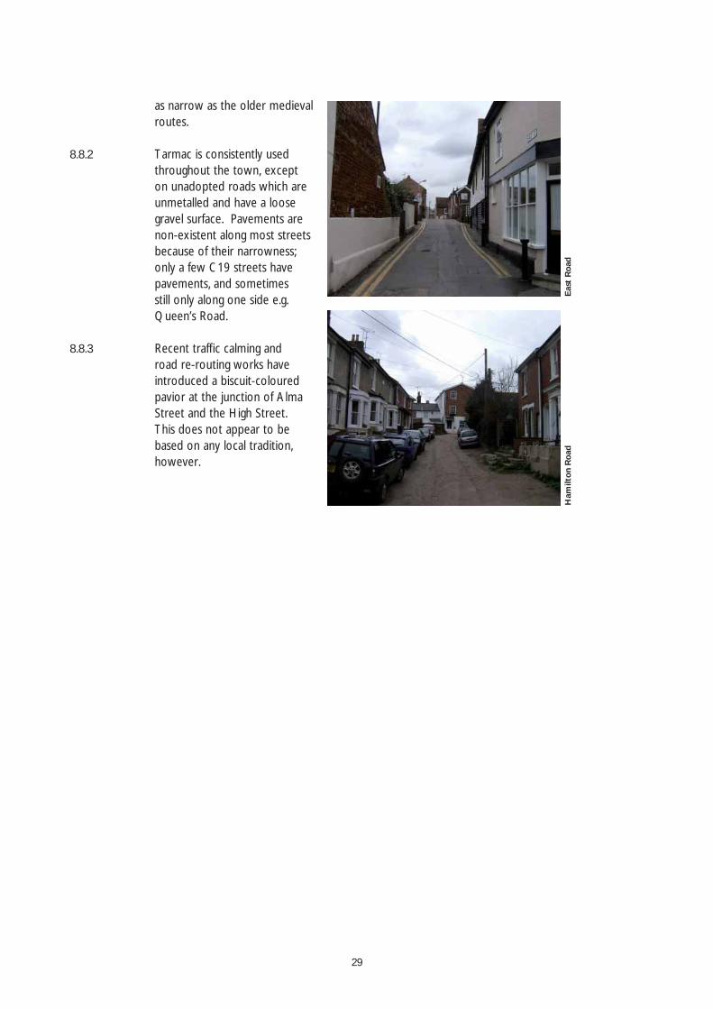
8.8 Public Realm
8.8.1 The historic core has an irregular street pattern of very narrow and intimate routes, some of these refl ecting the historical evolution of the town with short lanes running down to the river from the main east-west routes. The C19 streets in contrast are often very straight, although many are just B
etha
ny S
tree
t
29
as narrow as the older medieval routes.
8.8.2 Tarmac is consistently used throughout the town, except on unadopted roads which are unmetalled and have a loose gravel surface. Pavements are non-existent along most streets because of their narrowness; only a few C19 streets have pavements, and sometimes still only along one side e.g. Queen’s Road.
8.8.3 Recent traffi c calming and road re-routing works have introduced a biscuit-coloured pavior at the junction of Alma Street and the High Street. This does not appear to be based on any local tradition, however.
Eas
t R
oad
Ham
ilton
Roa
d
30
9.0 Proposed Boundary Changes
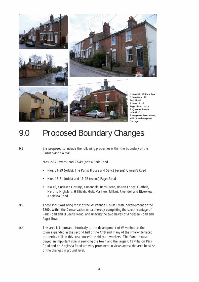
9.1 It is proposed to include the following properties within the boundary of the Conservation Area:
Nos. 2-12 (evens) and 27-49 (odds) Park Road
Nos. 21-29 (odds), The Pump House and 58-72 (evens) Queen’s Road
Nos. 15-21 (odds) and 16-22 (evens) Paget Road
No.16, Anglesea Cottage, Annandale, Berri-Dene, Bolton Lodge, Gimbals, Herons, Highclere, Hillifi elds, Holt, Mariners, Millcot, Rivendell and Riverview, Anglesea Road
9.2 These inclusions bring most of the Wivenhoe House Estate development of the 1860s within the Conservation Area, thereby completing the street frontage of Park Road and Queen’s Road, and unifying the two halves of Anglesea Road and Paget Road.
9.3 This area is important historically to the development of Wivenhoe as the town expanded in the second half of the C19 and many of the smaller terraced properties built in this area housed the shipyard workers. The Pump House played an important role in servicing the town and the larger C19 villas on Park Road and on Anglesea Road are very prominent in views across the area because of the changes in ground level.
•
•
•
1
2
3
4
5
1. Nos 35 - 45 Park Road2. Nos 8 and 10 Park Road3. Nos 17 -19 Paget Road north 4. Queen’s Road - no’s 62 - 725. Anglesea Road - Holt, Millcot and Anglesea Cottage
31
10.0 Introduction
10.1 The following guidance aims to provide the basis of a mid- to long-term management strategy for the Wivenhoe Conservation Area. It should be read in conjunction with the Adopted Review Colchester Borough Local Plan (March 2004), although this will be replaced by a Local Development Framework in the next couple of years. In addition to the appropriate local planning policies, the requirements of the Building Regulations and Fire Precautions Act should be carefully considered.
PART B: MANAGEMENT GUIDELINES
32
11.0 Article 4 Directions
11.1 Although conservation area designation restricts some ‘permitted development’ rights, many of Wivenhoe’s unlisted historic buildings have none-the-less been disfi gured by the gradual replacement of original and traditional features such as windows, doors, roofi ng materials, etc. which are still permitted under Schedule 2 of the Town and Country Planning (General Permitted Development) Order 1995. Article 4 directions can be used by a local authority to withdraw further permitted development rights.
11.2 Article 4(1) directions can be used to withdraw permitted development rights on any type of building or land, whether or not it fronts onto a highway, waterway or open space, but they need to be approved by the First Secretary of State. Such directions are not considered to be appropriate in Wivenhoe as most disfi guring alterations that do not require planning permission are those undertaken by householders.
11.3 Article 4(2) directions can be used to withdraw permitted development rights for a prescribed range of development that materially affects aspects of the external appearance of dwelling houses and associated buildings and structures that front onto highways, waterways or open spaces in conservation areas. The uniformity of many of the terraces and the symmetry of a number of semi-detached pairs of houses in Wivenhoe has been eroded by a range of minor permitted development. Individual detached dwellings are also marred by the use of modern materials and replacement windows, doors etc. which cannot replicate the subtle detailing of the traditional.
11.4 It is therefore suggested that an Article 4(2) direction is used to withdraw an array of permitted development rights from most residential properties in Wivenhoe. Most of the small number of modern properties should probably be excluded from such a direction as they lack suffi cient interest for it to be worthwhile imposing planning restrictions.
11.5 An Article 4(2) direction could be served to restrict the following types of development:
Erection, alteration or removal of a chimney
Construction of an external porch, conservatory or door hood and canopy
•
•
33
Painting of a dwelling house
Demolition of a gate, fence, wall or other means of enclosure if it is within the curtilage of a dwelling house and fronts a highway, waterway or open space
Replacement of roof coverings
Replacement of windows or doors and changes to window or door openings
Such a direction would require the affected householders to seek planning permission for the above range of development.
11.6 If an Article 4(2) direction was proposed, it would be subject to further public consultation by Colchester Borough Council. Local people will be notifi ed of any such proposal and the Borough Council will take account of public views before deciding whether to confi rm the Article 4(2) direction. If confi rmed, Colchester Borough Council will give notice by advertisement in a local newspaper to all properties affected by the direction. The occupiers or owners (if there is no occupier) of affected properties will also be notifi ed.
•
•
•
•
34
12.0 Enhancement Opportunities
12.1 The repaving and enhancement of Anchor Hill and Black Buoy Hill would signifi cantly enhance the quality of these key spaces and highlight their importance to the character of the town. Such works need to specify appropriate, high quality paving materials, streetlights and other street furniture of a suitable scale and style. Public realm enhancements should extend to key streets within the historic core of Wivenhoe creating a distinct character separate from the more formal C19 streets.
12.2 The replacement of the rather utilitarian metal-wire fencing on the south side of Phillip Road with a more appropriate boundary treatment such as the railings along Station Road would improve the street’s southern outlook and enhance views across to St Mary’s Church.
12.3 The recent highways works which have seen the closure of some streets have greatly increased the amount of highway signage, detrimentally affecting the visual appearance of the conservation area and causing obstructions for pedestrians. The gradual reduction of these signs or their replacement with more appropriate versions would greatly enhance the quality of the public realm in the conservation area.
12.4 The topography of the area combined with the narrow streets means that the telegraph poles with their connecting overhead wires are very prominent along many of the streets, creating visual clutter on the skyline. Their removal and relocation of services underground is desirable in the majority of the streets, but their removal would necessitate the replacement of the streetlights presently mounted on the telegraph poles. The telegraph poles would then effectively be replaced by a similar number of lamp-posts, the design and location of which would need to be carefully considered. Some individual lamp-posts are already being installed to replace streetlights previously mounted on buildings.
12.5 Many of the C19 streets in particular are dominated by parked cars. This together with the relatively frequent traffi c in some of the busier streets can create an unwelcoming pedestrian environment. Public realm enhancements could perhaps help to reduce the visual impact of parked cars and provide more pedestrian-friendly spaces.
12.6 The Wivenhoe Business Centre on Brook Street is well-used and very important to the future life of the town, stopping it from becoming just another commuter town. The buildings and their associated parking are not however particularly attractive. Their appropriate screening or gradual redevelopment (retaining the
35
business use in the area) would be desirable to improve the visual amenity of this part of the conservation area. The centre’s improvement would also enhance the quality of the new ‘square’ that is to be created at the northern end of St John’s Road as part of the new housing development.
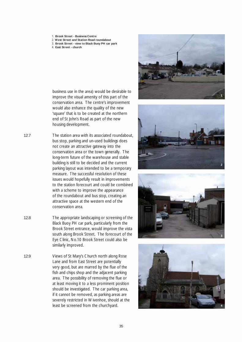
12.7 The station area with its associated roundabout, bus stop, parking and un-used buildings does not create an attractive gateway into the conservation area or the town generally. The long-term future of the warehouse and stable building is still to be decided and the current parking layout was intended to be a temporary measure. The successful resolution of these issues would hopefully result in improvements to the station forecourt and could be combined with a scheme to improve the appearance of the roundabout and bus stop, creating an attractive space at the western end of the conservation area.
12.8 The appropriate landscaping or screening of the Black Buoy PH car park, particularly from the Brook Street entrance, would improve the vista south along Brook Street. The forecourt of the Eye Clinic, No.10 Brook Street could also be similarly improved.
12.9 Views of St Mary’s Church north along Rose Lane and from East Street are potentially very good, but are marred by the fl ue of the fi sh and chips shop and the adjacent parking area. The possibility of removing the fl ue or at least moving it to a less prominent position should be investigated. The car parking area, if it cannot be removed, as parking areas are severely restricted in Wivenhoe, should at the least be screened from the churchyard.
1
2
3
4
1. Brook Street - Business Centre2. West Street and Station Road roundabout3. Brook Street - view to Black Buoy PH car park4. East Street - church
36
13.0 Policy Guidance
13.1 When considering the design of new buildings or extensions to existing ones, the Council will take into account the impact of the proposal on the setting of Listed Buildings and the character and appearance of the Conservation Area. Section 8 of this document sets out some of the key characteristics which need to be considered if a design is to fi t comfortably with its neighbours. Any application to extend a new building or build a new one must be accompanied by a Design Statement which explains how the proposal conforms to the key characteristics identifi ed in the appraisal, or if it does not conform, why this particular approach is felt to be appropriate.
13.2 The Council will work with the Highway Authority and other statutory undertakers
to reduce the visual impact of plant, road signs and other ‘street furniture’. Where signs are needed, wherever possible they will be fi xed to existing features rather than being pole-mounted. Appropriate designs and colours for street furniture will be encouraged and necessarily unattractive plant appropriately screened. Care will be taken to ensure that signs are not located in visually prominent locations including those in the vicinity of important Listed Buildings.
A proliferation of signs and posts will be avoided where possible and signs will be restricted to those that are essential, ensuring that they are of a character and quality appropriate to the Wivenhoe context. Signs will comply with ‘The Traffi c Signs Regulations’ and the Department of Transport’s ‘Traffi c Signs Manual’ which allow a degree of fl exibility in the size, siting and colour of signs.
13.3 When considering proposals for repaving or resurfacing streets and paths within the Conservation Area, the Council will work with the Highway Authority to ensure that appropriate materials are used which respect and complement the character of the area. The use of textured traditional materials will be used where possible to reduce traffi c speeds. Paving materials will also be carefully chosen to ensure that they are durable enough to support the weight of heavy vehicles and that they are stain-resistant.
13.4 In line with national local planning policy, there will be a general presumption against the demolition of Listed Buildings (including their outbuildings) and buildings of townscape value which are identifi ed in the Conservation Area Appraisal.
37
The demolition of other buildings in the area will be approved provided that:-
The building(s) is/are identifi ed as making either a negative or insignifi cant contribution to the character or appearance of the area.
Any replacement building or feature will preserve or enhance the character and appearance of the Conservation Area. Any application for a replacement building must be accompanied by a design statement which describes how the new building respects the ‘Key Characteristics’ of the area as defi ned in the Conservation Area Appraisal.
To avoid unsightly gaps in the Conservation Area, a condition will be imposed on any grant of Conservation Area Consent which prevents the demolition taking place until a contract has been let for the redevelopment of the site.
13.5 Where traditional shopfronts, or elements of them, survive, they should be retained and used as the basis for the restoration of the original frontage or incorporated into an appropriate new shopfront design. Removal of original features will only be permitted if they are beyond repair or are incapable of being successfully incorporated into a new shopfront.
The replacement of inappropriate shopfronts will be encouraged provided that the replacement respects the character of the building, adjacent buildings if part of a group or terrace, or the area as a whole.
Where change of use is sought for the conversion of a shop back to residential use and elements of an original or appropriate shopfront survive, these will be retained in any conversion unless they are completely beyond repair.
•
•
•
38
14.0 Urgent Works and Repairs Notices
14.1 Where emergency or immediate repairs to arrest the deterioration of a building are needed, the local authority can serve urgent works notices on the unoccupied parts of both listed and unlisted buildings in conservation areas (although in the case of the latter, only with the agreement of the Secretary of State for Culture, Media and Sport, advised by English Heritage). Repairs notices requiring works that are reasonably necessary for the proper preservation of a building to be undertaken, can only be served by the local authority on statutorily listed buildings.
14.2 Urgent works and repairs notices can be very effective in helping to secure the future of listed buildings and unlisted buildings that contribute positively to the special interest of a conservation area. Further details of these notices are available in English Heritage’s guide ‘Stopping the Rot’.
14.3 If the condition of any land or building in the conservation area is adversely affecting the amenity of the area, the local authority can serve a Section 215 notice on the owner or occupier, requiring the person responsible to clean up the site or building. Further details can be found in the former ODPM’s ‘Best Practice Guidance’ on the use of Section 215 notices.
39
15.0 References
Townscape Character Assessments: Colchester, Tiptree, West Mersea & Wivenhoe; Chris Blandford Associates, June 2006
Review of Countryside Conservation Areas in Colchester Borough; Chris Blandford Associates, August 2005
Wivenhoe Historic Towns Project Assessment Report; Maria Medleycot (Essex County Council), May 1998
The Buildings of England: Essex; Nikolaus Pevsner
The Story of Wivenhoe; Nicholas Butler, 1989
With many thanks to The Wivenhoe Society for their help and advice in the production of this document.
Thank you also to the Wivenhoe Town Council for their help in organizing the consultation and the Queen’s Road Residents’ Association for their comments.
•
•
•
•
•
•
•

MAPS
QuBE Planning Ltd.Building 14
Michael Young CentrePurbeck Road
Cambridge CB2 8PFtel. 01223 275710fax 01223 275711
Colchester Borough CouncilPlanning, Protection and LicensingPO Box 889Town Hall Colchester CO1 1FLtel. 01206 282222fax 01206 282598www.colchester.gov.uk
THE FOLLY
REBOW ROAD
HIG
H S
TREE
T
QUEEN’S ROAD
MALTING YARD
PARK
ROA
D
QUEEN’S ROAD
PAG
ET R
OA
D
PAG
ET R
OA
D
AN
GLE
SEA
RO
AD
BROOK
BRO
OK
STREET
STRE
ET
HA
MIL
TON
RDHAMILTON RD
WA
LTER RAD
CLIFFE W
AY
ST JO
HN
’S R
OA
D
HA
RDIN
GS Y
ARD
ROSE
LAN
E
THE QUAY
ANCHOR
HILL
WEST QUAY
QU
AY S
TREE
T
BATH
STR
EET
EAST STREETW
EST STREET
TERN MEWS
STATION ROAD
CLIFTON TERRACE
CH
APEL ROAD
FALCON YARD
BELLE VUE ROAD
ALM
A S
TR
EET
BETH
AN
Y ST
REET
ALMA STREET
HIG
H S
TREE
T
BLA
CK
BU
OY
HIL
L
Conservation area boundary
Proposed addition
Listed buildings
TPO
Buildings of townscape value
Negative building
Negative floorscape
Negative feature
Positive feature
Panorama
Negative vista
Positive vista
Positive frontage
Negative boundary
Positive boundary
Landmark building
Important trees
Positive hedgeline
Key space
Key green space
Figure 1
Townscape analysis
THE FOLLY
REBOW ROAD
HIG
H S
TREE
T
QUEEN’S ROAD
MALTING YARD
PARK
ROA
D
QUEEN’S ROAD
PAG
ET R
OA
D
PAG
ET R
OA
D
AN
GLE
SEA
RO
AD
BROOK
BRO
OK
STREET
STRE
ET
HA
MIL
TON
RDHAMILTON RD
WA
LTER RAD
CLIFFE W
AY
ST JO
HN
’S R
OA
D
HA
RDIN
GS Y
ARD
ROSE
LAN
E
THE QUAY
ANCHOR
HILL
WEST QUAY
QU
AY S
TREE
T
BATH
STR
EET
EAST STREET
WEST STREET
TERN MEWS
STATION ROAD
CLIFTON TERRACE
CH
APEL ROAD
FALCON YARD
ALM
A S
TR
EET
BELLE VUE ROAD
BETH
AN
Y ST
REET
HIG
H S
TREE
T
ALMA STREET
BLA
CK
BU
OY
HIL
L
Proposed Conservation A
rea boundary
Wivenhoe H
ouse Estate Developm
ent
Victorian streets
Previously existing streets
Historic core
Figure 2
Character A
reas
C19 W
ivenhoe
THE FOLLY
REBOW ROAD
HIG
H S
TREE
T
QUEEN’S ROAD
MALTING YARD
PARK
ROA
D
QUEEN’S ROADPA
GET
RO
AD
PAG
ET R
OA
D
AN
GLE
SEA
RO
AD
BROOK
BRO
OK
STREET
STRE
ET
HA
MIL
TON
RDHAMILTON RD
WA
LTER RAD
CLIFFE W
AY
ST JO
HN
’S R
OA
D
BETH
AN
Y ST
REET
HA
RDIN
GS Y
ARD
ROSE
LAN
E
THE QUAY
ANCHOR
HILL
WEST QUAY
QU
AY S
TREE
T
BATH
STR
EET
EAST STREET
WEST STREET
TERN MEWS
STATION ROAD
CLIFTON TERRACE
CH
APEL ROAD
FALCON YARD
ALM
A S
TR
EET
BELLE VUE ROAD
ALMA STREET
HIG
H S
TREE
T
BLA
CK
BU
OY
HIL
L
Proposed Conservation A
rea boundary
Green space
Residential
Public / Com
munity
Com
mercial
Railw
ay land
Car parking
Developm
ent area
Figure 3
Land use


![Wivenhoe Management Group[2]](https://img.pdfslide.net/doc/110x75/5567bf84d8b42a944b8b5288/wivenhoe-management-group2.jpg)
