Embed Size (px)
Citation preview
GCSE GEOLOGY 1
Contents
WJEC GCSE in GEOLOGY
For Teaching from 2009 For Award from 2011
Page
Summary of Assessment 2 Introduction 3 Specification Content 6
Scheme of Assessment 24 Awarding, Reporting and Re-sitting 29
Administration of Controlled Assessment 30 Grade Descriptions 32 The Wider Curriculum 34
Appendix 36
GCSE GEOLOGY 2
GEOLOGY
SUMMARY OF ASSESSMENT
Theory Paper - external assessment 75% 1½hr 100 marks An on-screen non-tiered written paper consisting of compulsory structured data and stimulus response questions, marked by WJEC. Controlled internal assessment 25% 50 marks Option 1 Directed investigation of a virtual location presented as 'field' notes and a written report. Marked by centre.
Or Option 2 Directed investigation of an actual location presented as field notes and a written report. Marked by centre.
Assessment Weighting Mark Theory paper (data response) 75% 100 Internal assessment Option 1
25%
50
or
Internal assessment Option 2 First Assessment and Award: Summer 2011
Subject Entry Codes Subject Option* GCSE Geology 4250 SA or GU
* Option Codes: English Medium SA, Welsh Medium GU
Qualification Accreditation Number: 500/4591/X
GCSE GEOLOGY 3
GEOLOGY 1 INTRODUCTION 1.1 Rationale
This specification contributes to the national provision of science by providing a course and assessment in geology at GCSE level. It provides an interdisciplinary and integrated approach to science.
1.2 Aims and Learning Outcomes
The aims set out below describe the educational purposes of a course in GEOLOGY for the GCSE examination. Some of these aims are reflected in the assessment objectives; others are not because they cannot readily be translated into objectives that can be assessed.
This course in GCSE GEOLOGY should encourage students to:
1. develop interest in, and enthusiasm for, geology; 2. develop a critical approach to geological evidence and methods; 3. acquire and apply skills, knowledge and understanding of how geological
science works and its essential role in society, including:
• acquiring the background knowledge and understanding of the major concepts of geology;
• developing scientific skills and skills of geology, particularly: • spatial skills; • time skills; • fieldwork methodology used to study geology; • working with large incomplete datasets; • interpretation of the past; • studying the Earth as a series of systems;
• developing abilities and skills that: • are useful in everyday life; • encourage safe practice; • enable the selection, organisation and presentation of information
clearly and logically, using ICT. • developing an awareness that:
• geology study and practice involves co-operative and cumulative activities which are subject to changing social, economic, technological, ethical and cultural influences and limitations;
• applications of geology may be both beneficial and detrimental to the individual, the community and the environment.
• developing their interest in, and care for, the environment; • discovering how geoscientists work and what they do

GCSE GEOLOGY 4
4. appreciate the contribution of geology to the objective understanding of the material world;
5. acquire geological skills, knowledge and understanding necessary for progression to further learning.
Skills, Knowledge and Understanding
All candidates must meet the following assessment objectives in the context of the
prescribed skills, knowledge and understanding. Within the assessment objectives, candidates are required to use communication skills, including ICT, use scientific conventions (including chemical equations) and mathematical language (including formulae), where appropriate.
Assessment Objective 1 (AO1): Knowledge and understanding of geology and
how the science works
Candidates should be able to:
(a) demonstrate knowledge and understanding of the geological facts, concepts, techniques and terminology in the specification
(b) relate data collected, or given, to current geological explanations and theories
(c) show understanding of how geological knowledge and ideas change with time and how these changes are validated.
Assessment Objective 2 (AO2): Application of skills, knowledge and understanding
Candidates should be able to:
(a) plan a geological task, such as a practical procedure, testing an idea,
answering a question, or solving a problem
(b) apply concepts, develop arguments in familiar and unfamiliar situations including those related to geological applications in a range of domestic, industrial and environmental contexts
(c) show how an understanding of geology affects decisions made in different
situations, including contemporary situations and those raising ethical issues
(d) evaluate the impact of geological processes on individuals, communities or the environment.
Assessment Objective 3 (AO3): Practical, enquiry and data-handling skills
Candidates should be able to:
(a) carry out practical and field-related tasks safely and skilfully, methodically recording suitable and accurate data
(b) show an understanding of how geological data are collected
(c) analyse and interpret qualitative and quantitative geological data and draw conclusions from different sources including the field
(d) evaluate the methods used when collecting first-hand and/or secondary data.

GCSE GEOLOGY 5
1.3 Prior Learning and Progression Although there is no specific requirement for prior learning, this specification builds
upon the study of science and geography in Key Stages 1-3.
This specification may be followed by any candidate, irrespective of their gender, ethnic, religious or cultural background. This specification is not age specific and, as such, provides opportunities for candidates to extend their life-long learning.
1.4 Equality and Fair Assessment
GCSEs often require assessment of a broad range of competences. This is because they are general qualifications and, as such, prepare candidates for a wide range of occupations and higher level courses.
The revised GCSE qualification and subject criteria have been reviewed to identify whether any of the competences required by the subject presented a potential barrier to any disabled candidates. If this was the case, the situation was reviewed again to ensure that such competences were included only where essential to the subject. The findings of this process were discussed with disability groups and with disabled people.
Requirements for controlled internal assessment are sufficiently flexible for all
candidates to participate. However, candidates with visual impairments may having difficulty in observations of maps and specimens, although technology can be used to assist in this.
Reasonable adjustments are made for disabled candidates in order to enable them to access the assessments. For this reason, very few candidates will have a complete barrier to any part of the assessment. Information on reasonable adjustments is found in the Joint Council for Qualifications document Regulations and Guidance Relating to Candidates who are eligible for Adjustments in Examinations. This document is available on the JCQ website (www.jcq.org.uk).
Candidates who are still unable to access a significant part of the assessment, even after exploring all possibilities through reasonable adjustments, may still be able to receive an award. They would be given a grade on the parts of the assessment they have taken and there would be an indication on their certificate that not all of the competences have been addressed. This will be kept under review and may be amended in future.
1.5 Classification Codes
Every specification is assigned a national classification code indicating the subject area to which it belongs. The classification code for this specification is 1770.
Centres should be aware that candidates who enter for more than one GCSE qualification with the same classification code will have only one grade (the highest) counted for the purpose of the School and College Performance Tables.
Centres may wish to advise candidates that, if they take two specifications with the same classification code, schools and colleges are very likely to take the view that they have achieved only one of the two GCSEs. The same view may be taken if candidates take two GCSE specifications that have different classification codes but have significant overlap of content. Candidates who have any doubts about their subject combinations should check with the institution to which they wish to progress before embarking on their programmes.
GCSE GEOLOGY 6
2 CONTENT Key Idea 1: Rock exposures contain evidence of how the rocks were formed and subsequently deformed This Key Idea enables candidates to analyse and interpret a rock exposure from primary and secondary evidence. 1.1 Rock exposures are formed of minerals, rocks and fossils
Knowledge and understanding
Techniques and skills
Minerals are naturally occurring elements or compounds with fixed properties
Distinguish between minerals, rocks and fossils in specimens, photographs, or rock exposures in the field.
Rocks are naturally occurring materials formed of minerals or fragments of rocks or fossils
Fossils are any preserved sign of past life, more than 10,000 years old 1.2 Minerals are formed in a number of geological environments
Knowledge and understanding
Techniques and skills
Minerals are formed by: • crystallisation from a melt [quartz, feldspar, mica] • metamorphic recrystallisation [calcite, garnet] • crystallisation from solution in evaporating water [halite] • crystallisation as cement from flowing pore waters [quartz, calcite] • crystallisation from hydrothermal fluids [in veins and faults; gangue minerals;
quartz, calcite, ore minerals; haematite, galena]
Interpret the mode of mineral formation from the characteristics of the mineral [seen in hand specimen using a hand lens, or in a diagram/photograph] and the geological environment in which it is found [from melt, metamorphism, evaporation, as cement, from hydrothermal fluids]
The minerals in sedimentary rocks have undergone sedimentary processes [rounding, sorting]
Identify sedimentary minerals by their textures [use of shape chart to determine rounding and observation of range of grain size to determine sorting]
Minerals can be valuable if they contain metals [ores: haematite, galena, gold] or have properties such as being rare, hard, lustrous and/or coloured that cause them to become precious or semi-precious stones [quartz (amethyst), diamond]
Use appropriate tests [observation of colour, hardness, streak, cleavage, lustre, density and reaction with 0.5 mol dm-3 hydrochloric acid to identify and distinguish between the following minerals: quartz, calcite, haematite, galena]. Interpret data from the data sheet.
GCSE GEOLOGY 7
1.3 Sedimentary rocks are formed by a range of surface processes in a variety of environments
Knowledge and understanding
Techniques and skills
Sedimentary rocks [breccia, conglomerate, sandstone, shale, limestone] have diagnostic properties [colour; texture (grain size/sorting and shape), reaction with acid]
Identify the stated sedimentary rocks in hand specimen from their texture [use of: sediment size comparator to determine grain size; shape chart to determine grain shape; reaction with 0.5M hydrochloric acid], structures [lamination/bedding, graded bedding, cross bedding, ripple marks, desiccation cracks] and other diagnostic features
Sedimentary rock type is dependent upon the environment of deposition. Shallow marine: limestones, sandstones and conglomerates Deep marine: turbidites, black shales Land: shales, sandstones, coal [deposited by rivers and deltas] breccias, desert sandstones [wind and water deposited], evaporites [halite] deposited by precipitation from saline water
during evaporation glacial till deposited by melting ice
Use the characteristics of sedimentary rocks, including their distinctive sedimentary textures and structures and their fossil content, as seen in hand specimens, rock exposures, diagrams/photographs and analysis of simple geological maps and cross sections to interpret their environments of deposition
Distinctive sedimentary structures [lamination/bedding, cross bedding, graded bedding, ripple marks, desiccation cracks] are characteristic of these environments of deposition
Fossils are indicators of past environments: • reef-building corals [marine, shallow, warm], • trilobite [marine], ammonite [marine], • plants [land, indicating past climate], • trace fossils [tracks indicating land, burrows indicating shallow water]
Distinguish between the following fossil groups on the basis of their morphology [trilobite, ammonite, coral]
Sediment is compacted [shale] and cemented [sandstone] influencing porosity and permeability.
Distinguish permeable from impermeable rocks by observing the effects of dropping water on specimens and by immersing them in water

GCSE GEOLOGY 8
1.4 Igneous rocks and processes
Knowledge and understanding
Techniques and skills
Igneous rocks [gabbro, basalt, granite] have diagnostic properties [colour; texture (crystal size and orientation)]
Identify the stated igneous rocks in hand specimen from observation of their colour, crystal size [coarse, fine] and random crystal orientation
Crystal size in igneous rocks is related to the cooling rate of a magma Magma viscosity affects the type of volcanic activity and the shape of the volcano - the differences between relatively passive [fissure] and violent eruptions [central vent]
Recognise and interpret the differing shapes of volcanoes from diagrams/photographs
Igneous bodies can be distinguished by their structures and field relationships • lava flows [tabular form, columnar jointing, pillow lava] • sills, dykes and plutons [form, relationship to bedding, baked and chilled
margins]
Identify the characteristics of igneous bodies [structures, field relationships] as seen in rock exposures, diagrams/photographs and analysis of simple geological maps and cross sections to interpret their contrasting modes of formation
1.5 Metamorphic rocks and processes
Knowledge and understanding
Techniques and skills
Metamorphic rocks [slate, schist, marble] have diagnostic properties: [texture (crystal size and orientation); acid reaction]
Identify the stated metamorphic rocks in hand specimen from observation of their crystal size [coarse, fine]; aligned crystal orientation; and reaction with reaction with 0.5 mol dm-3 hydrochloric acid
Metamorphic rocks are the result of temperature and/or pressure on pre-existing rocks causing recrystallisation to form new minerals. Non-foliated texture [metamorphic aureole], Foliated texture [slatey cleavage and schistosity]
Use the characteristics of metamorphic rocks [texture, acid reaction] as seen in hand specimens, diagrams/photographs and analysis of simple geological maps and cross sections to interpret their contrasting modes of formation

GCSE GEOLOGY 9
1.6 Geological Structures
Knowledge and understanding
Techniques and skills
The rock record provides evidence of tectonic activity Measure strike and dip Carry out simple analysis of strike and dip measurements to describe and interpret rock structures
Recognise and describe the appearance of rock structures [fold, fault, unconformity (angular), extrusive and intrusive body, metamorphic aureole] in rock exposures, diagrams, simplified maps and block diagrams
Folding is caused by tectonic stress [compressional] Interpret features of folding in rock exposures, diagrams, simplified maps and block diagrams
• horizontal beds • dipping beds • folded beds [anticlines and synclines axial plane trace]
Faulting is caused by tectonic stress [compressional, tensional, shear] Interpret features of rock deformation by faulting in rock exposures,
diagrams, simplified maps and block diagrams • normal fault • reverse/thrust fault • strike-slip fault • fault displacement
Unconformities are breaks in the rock record Unconformities (angular) are formed by a sequence of events including deformation, uplift, erosion and later deposition
Identify unconformities on photographs, diagrams, maps and cross sections. Recognise the use of unconformities in interpreting the geological history of exposures
GCSE GEOLOGY 10
1.7 Rock exposures contain evidence of the sequence of geological events that formed and deformed them
Knowledge and understanding
Techniques and skills
Geological events are dated and interpreted using: • the principle of Uniformitarianism (the present is the key to the past) • the concepts of original horizontality, lateral continuity and superposition of strata • the dating of rocks on the basis of included fragments, cross cutting relationships
Apply these stratigraphic principles of relative dating to interpret the evidence in rock exposures in the field or in diagrams, photographs, maps or cross sections for the sequence of geological events that formed/deformed them
Rocks can be dated and correlated using fossils The following fossil groups have morphological changes with time that can be used in correlation: • cephalopods [goniatites, ceratites, ammonites - suture line] • graptolites [stipes, thecae]
Use the stated fossils, as seen in specimens, drawings or photographs to interpret the history of a rock sequence
The decay of radioactive materials provides a method for calculating the absolute age of some rocks and minerals
Carry out a simple analysis of the age of a radioactive mineral based on the half life concept [parent - daughter ratio, unstable parent, stable daughter]
GCSE GEOLOGY 11
Key Idea 2: The character of the landscape contains evidence of the relationship between past and present processes and the underlying geology This Key Idea enables candidates to ‘read’ the landscape for evidence of landscape-formation processes 2.1 The landscape is subject to processes of weathering, erosion and transportation
Knowledge and understanding
Techniques and skills
Rock surfaces are changed by weathering processes. Weathering is the breakdown of rocks in situ by physical, chemical and biological processes • the physical weathering of rocks by freeze/thaw producing angular rock fragments • the chemical weathering of granite to produce sand, clay and soluble material • the chemical weathering of limestone by the action of weak acids producing
soluble materials • biological weathering by plant roots and organic acids
Investigate exposed rock surfaces for weathering and interpret the evidence for • physical weathering • chemical weathering • biological weathering
Erosion involves the transportation of solid weathering products by water, wind, ice or gravity • Water, ice and wind erode rocks [abrasion, attrition] • They transport and deposit sediment [traction, saltation, suspension, solution] • Debris accumulates at the foot of slopes due to gravity [scree]
Rock is broken down by weathering and erosion into particles of various sizes and dissolved materials that can be incorporated into new sediments The grain size, shape and sorting of the resultant sediment is influenced by: the energy of the transporting medium, the depositional environment and time [screes; rivers; shallow/deep seas; wind-formed dunes]
Interpret the • Environment [need this as well as variations within the
environments as shown below] • length of time [can't do absolute time] and distance of transport
from the shape and sorting of sediment • energy of the environment of deposition from sediment grain
size
GCSE GEOLOGY 12
2.2 Valley shapes generally reflect the mode of their formation
Knowledge and understanding
Techniques and skills
River erosion in upland areas often forms ‘V’-shaped valleys
Describe valley cross profiles from maps, photographs and field observation to interpret the process responsible for valley shape.
‘U’-shaped valleys reflect glacial action
Valleys in lowland areas usually have wide flat floodplains
Valleys may or may not reflect underlying geological structure [discordant drainage]
2.3 Landforms often reflect underlying geological structure
Knowledge and understanding
Techniques and skills
The variation in resistance to weathering and erosion of different rock types and structures results in a variety of landforms: • Plateau – horizontal beds • Scarp and vale – gently dipping beds • Ridge – steeply dipping beds; dyke • Upland area – pluton • Fault scarp • Coastal landforms [high cliffs, headlands and bays]
Interpret the relationship between geology and landforms using maps, photographs and field observations
2.4 Modification of the landscape by human activity is often influenced by the underlying geology
Knowledge and understanding
Techniques and skills
The landscape can be modified by: • quarries and gravel pits excavated for raw materials, mainly for construction
[building stones, aggregate, cement, roadstone] • past mining activity [pits/shafts, spoil heaps, contaminated land] • cuttings/tunnels excavated for roads and railways which are subject to landslides Much evidence of past mining/quarrying activity can be removed by landscaping [country parks on ‘brownfield’ mining/quarrying sites]
Use data [from a field visit, text, drawings, photographs or maps] to interpret evidence of the stated human modifications of the landscape, including the effects of later landscaping

GCSE GEOLOGY 13
2.5 Important rock exposures should be conserved
Knowledge and understanding
Techniques and skills
Old quarries and cuttings can have scientific importance as Sites of Special Scientific Interest (SSSIs) or scientific, educational, historical or aesthetic importance as Regionally Important Geological or Geomorphological Sites (RIGS), but are also potential safety hazards unless well managed.
Interpret a SSSI or RIGS from a field or website visit. Describe potential safety hazards of quarries, cuttings and cliff faces

GCSE GEOLOGY 14
Key Idea 3: Some major concepts underpin our current understanding of the Earth This Key Idea enables candidates to demonstrate an understanding of some of the ‘big ideas’ of geology 3.1 Rock cycle (Hutton, 18th Century)
Knowledge and understanding
Techniques and skills
Sedimentary, metamorphic and igneous processes and rocks are linked by the rock cycle.
Interpret rock cycle diagrams
Stratigraphic principles are based on the Principle of Uniformitarianism – “the Present is the Key to the Past”
Investigate the link between ancient and modern processes reflected in the rock record by applying the principle of Uniformitarianism
Rock cycle processes take place at different rates, from seconds to millions of years [catastrophism v gradualism - e.g. meteorite impact v river erosion]
Distinguish between processes reflected in the rock record that occurred at different rates
GCSE GEOLOGY 15
3.2 Plate tectonics (20th Century)
Knowledge and understanding
Techniques and skills
With new evidence, Plate tectonic theory developed from Continental Drift [continental drift, Wegener (1915), evidence for sea floor spreading, Hess (1960), Vine and Matthews (1963), plate tectonics, J. Tuzo Wilson (1965)] There is a range of evidence supporting the theory of plate tectonics and the direction and rate of plate movement.
Analyse the evidence for plate tectonics [jigsaw pattern fit, fossil distributions, magnetic stripes, age of the ocean floor; direct laser measurements]
The lithosphere [cold, rigid outer shell, crust and uppermost mantle] is underlain by the asthenosphere [weaker layer]. The lithosphere is divided into a number of rigid plates which move relative to one another due to thermal convection in the mantle.
Use maps to interpret the global distributions of earthquakes, igneous rocks and mountain belts in the context of processes at or near to plate boundaries.
The relative movements between plates produce different effects at different types of plate boundary. • Divergent (constructive) plate margins: [basalt extrusion, sea floor spreading, the
origin of basaltic magma by partial melting of the upper mantle, ocean ridges, high heat flow, rift valleys, abyssal plain]
• Conservative plate margins: [earthquake activity, transform faults] (San Andreas fault zone)
• Convergent (destructive) plate margins : 1. oceanic-oceanic: [island arc/trench systems] (Java-Sumatra/Caribbean) 2. oceanic-continental: [active continental margins; subduction zones Benioff
zone, partial melting producing andesitic and granitic magmas] (the Andes) 3. continental – continental: [mountain building, folding, thrust faulting, partial
melting of the crust producing granites, associated regional metamorphism] (the Himalayas)
Interpret the relative movement of plates from their plate boundary context shown in maps/diagrams. Interpret the type of magmatism and seismic activity associated with different plate boundaries from data provided in text, diagrams, photographs or maps.
GCSE GEOLOGY 16
3.3 Global temperature/sea level change (21st Century)
Knowledge and understanding
Techniques and skills
The enhanced “greenhouse effect” is a major contributor to global temperature increases.
Interpret data showing evidence for the increased rate of “greenhouse gas” emissions.
There is evidence of increasing carbon dioxide, a major greenhouse gas, in the atmosphere from direct measurement and ice cores.
There are both positive [reduction of icecap albedo accelerating warming]; and negative [carbon dioxide dissolved in sea water, absorption by organisms, to form limestone] controls on the carbon dioxide content in the atmosphere.
Global warming affects continental ice sheet dimensions and global sea level
Investigate the evidence from the internet, maps and aerial images for past and current fluctuations in continental ice and the effect on global sea levels.
Evidence of global sea level change during Pleistocene glaciations comes from raised beaches, submerged forests, and drowned valleys.
Use maps, photographs, and diagrams to identify the characteristics of these three features.
GCSE GEOLOGY 17
Key Idea 4: Major geological events fit into a timeline, beginning with the formation of the Earth This Key Idea enables candidates to fit the major geological events that have affected the Earth and the UK into a timeline 4.1 The origin and development of life
Knowledge and understanding
Techniques and skills
Life probably originated from the oceans, 3 500Ma (black smokers or hydrothermal pools)
The diversity of life evolved through single cells, multicellular organisms, animals with hard parts, fish, amphibians, reptiles, mammals, birds and humans.
Use simple evolutionary trees diagrams (cladograms) to demonstrate evolutionary trends. Interpret data from the data sheet.
The development of the life on Earth was in stages punctuated by times of major extinction events (K/T mass extinction)
GCSE GEOLOGY 18
4.2 The British area moved from south of the Equator to its present position over geological time
Knowledge and understanding
Techniques and skills
The rocks of the Britain area provide evidence of changing latitude and climate as Britain moved northwards.
Interpret the evidence [from hand specimens of rocks and fossils, maps, photographs and diagrams] for the changes in latitude of the British area over time. Interpret data from the data sheet.
(i) Lower Palaeozoic - Britain was south of the equator: evidence for plate collision from Caledonian orogenic belt. • turbidites • granites, regional metamorphism, thrusts, folds
(ii) Upper Palaeozoic - Britain drifts across the equator. • tropical seas [limestone] • swamp forest [deltas, coal formation] • desert conditions 15oN [wind-formed dune-bedded sandstone, evaporites,
breccia]
(iii) Mesozoic - Britain at 30o - 40oN; separation of Africa from America • extensive warm seas [limestone]
(iv) Cenozoic - opening of north Atlantic; Britain at 50o - 60oN; diverging plate volcanism in NW Britain; glaciation • volcanism (flood basalts) • glaciation (glacial till)
GCSE GEOLOGY 19
Key Idea 5: Earth events occur frequently and are commonly reported in the media This Key Idea enables candidates to appreciate the importance of current geological events. 5.1 Earth hazards
Knowledge and understanding
Techniques and skills
Geological events can be hazardous: • earthquakes [shaking; triggering landslides] • volcanic eruptions [lava, ash, pyroclastic and mud flows] • landslides [and related subsidence] • tsunamis
Investigate and interpret geological data presented in the media relating to the distribution, measurement and possible causes of earthquakes, volcanic eruptions, landslides and associated tsunamis.
The level of risk of a hazard is associated with life and property and relates to • population density, • technology [buildings] • development [economic situation, education, communication]
Use examples to contrast the risk of naturally occurring hazards in areas of contrasting development (LEDC and MEDC)
The level of accurate hazard prediction is limited
Describe the following methods used in hazard prediction: hazard interval patterns (seismic gaps), ground deformation (tiltmeters), groundwater changes, gas emissions, early warning systems
The methods of reducing risk include appropriate building design and regulation, prediction, warning schemes, evacuation
GCSE GEOLOGY 20
5.2 Human impacts on climate change
Knowledge and understanding
Techniques and skills
The major sources of carbon dioxide in the atmosphere are volcanic emissions and the burning of fossil fuels
Evaluate the relative roles of volcanic emissions and fossil fuels in current rates of climate change
Currently, humans are attempting to reduce carbon dioxide emissions by the use of energy efficiency, renewable energy resources [hydroelectric, wind, geothermal (including heat engines)] and nuclear energy.
Interpret graphs showing UK energy sources Evaluate the efficiency of the different methods being considered for reducing carbon dioxide emissions Investigate the pros and cons of nuclear energy as an energy resource
It is possible that, in the future, some of the carbon dioxide produced by power stations may be sequestered in old oil/gas fields
As the Earth warms, some elements of weather become more extreme and unpredictable
Investigate the media coverage of current extreme weather events
5.3 Great fossil finds
Knowledge and understanding
Techniques and skills
Major finds include: • rare and exceptional preservation [Burgess shale fauna] • fossils that have shown how different groups of organisms are linked through
evolution [Archaeopteryx] • complex fossil skeletons that have to be interpreted from incomplete and
disarticulated remains [dinosaurs] • early hominids [“Lucy”] • exceptional current discoveries
Media research on great fossil finds

GCSE GEOLOGY 21
5.4 Planning/quarrying/landfill
Knowledge and understanding
Techniques and skills
Local planning and environmental issues are often raised by the extraction of limestone/aggregate/brick clay. The disposal of domestic and hazardous waste can cause problems with groundwater contamination and methane gas production.
Analyse the issues involved in the extraction of limestone/aggregate/brick earth in environmentally sensitive areas. Analyse the geological and environmental issues involved in the disposal of domestic and hazardous waste.
GCSE GEOLOGY 22
Key Idea 6: Professional geoscientists use a variety of investigational skills in their work This Key Idea aims to enable candidates to describe the present day roles of key professional geoscientists 6.1 Oil/gas prospecting
Knowledge and understanding
Techniques and skills
Geologists prospecting for new reserves use a variety of mapping and geophysical [seismic] techniques Oil and gas are hydrocarbon mixtures. The accumulation of oil and gas by migration from source beds to reservoir rocks depends upon the contrasting porosity and permeability of reservoir and cap rocks. The main types of trap for oil and gas are: anticline, fault, unconformity, salt dome There are technological difficulties and environmental issues involved in exploring for and extracting oil and natural gas.
Interpret data from maps, cross-sections and seismic surveys to identify possible gas/oilfields (on-shore and off-shore).
6.2 Mining/mineral prospecting
Knowledge and understanding
Techniques and skills
Geologists prospecting for valuable materials: • seek anomalies in background data [high geochemical concentrations; magnetic
anomalies] • use magnetic and geochemical survey methods - [sampling and analysis of soil
and river sediment]
Interpret geochemical and magnetic prospecting data to identify possible metalliferous mineral resources.

GCSE GEOLOGY 23
6.3 Hydrogeology
Knowledge and understanding
Techniques and skills
Hydrogeologists study: • the geological factors affect the siting of reservoirs and dams [permeability and
stability of bedrock, dip of strata, faults, joints] • underground water supplied from aquifers [water table, porosity, permeability,
wells, springs]
Use descriptions, diagrams, photographs, maps and cross sections to investigate the geological factors affecting the siting of reservoirs and dams Analyse different rock types for their suitability as an aquifer
6.4 Environmental geoscience
Knowledge and understanding
Techniques and skills
Environmental geologists study: • planning for and monitoring of waste disposal • monitoring of potentially polluted water • restoration of polluted soils
Investigate the suitability of a potential landfill site for the disposal of domestic waste from descriptions, diagrams, photographs, maps and cross sections
6.5 Geotechnical work
Knowledge and understanding
Techniques and skills
Geotechnical geologists investigate the stability and strength of bedrock in the context of: • foundations for buildings, dams • stability of tunnels, cuttings
Use data from descriptions, diagrams, photographs, maps and cross sections to interpret the stability of rock tunnels and cuttings
6.6 Academic research geologist
Knowledge and understanding
Techniques and skills
Academic research geologists: • tackle geological questions/hypotheses, • seek evidence, • develop conclusions, • review work of peers, • publish results
Investigate the development of the “impact” theory for the mass extinction at the K/T boundary (Alvarez)

GCSE GEOLOGY 24
3 ASSESSMENT 3.1 Scheme of Assessment
Assessment for GCSE Geology is untiered, i.e. all components/units cater for the full range of ability and allow access to grades A*-G for the subject award. Scheme of Assessment Written Examination Paper: 75%
This is a non-tiered written paper provided as an on-screen test. It consists of compulsory structured data and stimulus response questions. The paper comprises 75% of the overall assessment, carries 100 raw marks and is 1½ hr in duration. Controlled Internal Assessment: 25% The controlled internal assessment complements the theory paper by assessing the geological practical skills of candidates. There are two options available: Option 1 This is a directed investigation of a virtual location/outcrop. The aim of the investigation and materials (photographs, specimens, maps etc) will be supplied by WJEC. The task will vary annually. Option 2 This is a directed investigation of an actual location/outcrop. The aim of the investigation and the location are chosen by the centre. There should be some variation annually. Approval for the appropriateness of the investigation must be sought from the WJEC Chief Moderator before it is carried out. For both options, the field notes and report produced by the candidate are assessed by the teacher using the assessment framework given in the specification. It is very important that the field notes of each candidate be retained. The field notes of each candidate must accompany the report in the moderation submission. N.B. Whichever option is chosen, candidates should spend a minimum of three days (or the equivalent) engaged in fieldwork in order to develop the necessary skills. Safety is paramount, both in the field and in the laboratory and it is essential that all centres adhere to ‘The Geological Code of Conduct’ and the regulations of their centre concerning off-site activities.
GCSE GEOLOGY 25
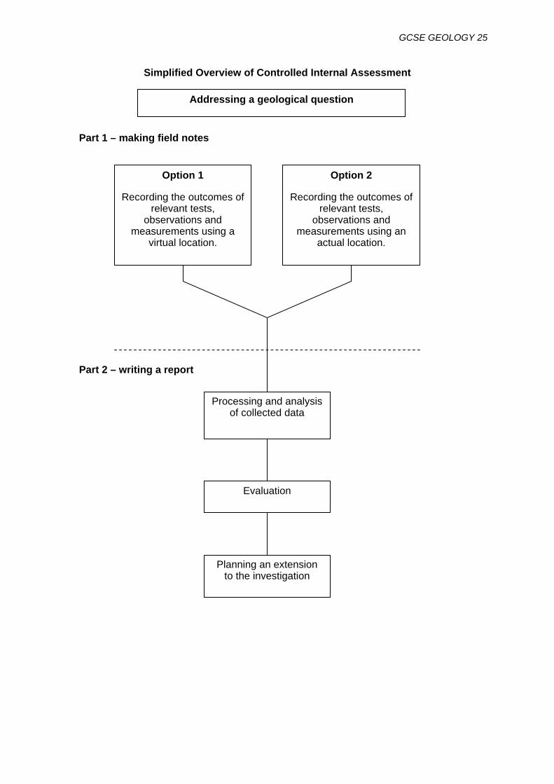
Simplified Overview of Controlled Internal Assessment
Option 1 Recording the outcomes of
relevant tests, observations and
measurements using a virtual location.
Option 2 Recording the outcomes of
relevant tests, observations and
measurements using an actual location.
Processing and analysis of collected data
Evaluation
Planning an extension to the investigation
Part 1 – making field notes
Part 2 – writing a report
Addressing a geological question
GCSE GEOLOGY 26
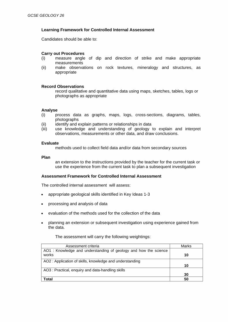
Learning Framework for Controlled Internal Assessment
Candidates should be able to:
Carry out Procedures
(i) measure angle of dip and direction of strike and make appropriate measurements
(ii) make observations on rock textures, mineralogy and structures, as appropriate
Record Observations record qualitative and quantitative data using maps, sketches, tables, logs or photographs as appropriate Analyse
(i) process data as graphs, maps, logs, cross-sections, diagrams, tables, photographs
(ii) identify and explain patterns or relationships in data (iii) use knowledge and understanding of geology to explain and interpret
observations, measurements or other data, and draw conclusions. Evaluate methods used to collect field data and/or data from secondary sources Plan an extension to the instructions provided by the teacher for the current task or use the experience from the current task to plan a subsequent investigation
Assessment Framework for Controlled Internal Assessment The controlled internal assessment will assess:
• appropriate geological skills identified in Key Ideas 1-3 • processing and analysis of data • evaluation of the methods used for the collection of the data • planning an extension or subsequent investigation using experience gained from
the data. The assessment will carry the following weightings:
Assessment criteria Marks AO1 : Knowledge and understanding of geology and how the science works
10
AO2 : Application of skills, knowledge and understanding 10
AO3 : Practical, enquiry and data-handling skills
30
Total 50
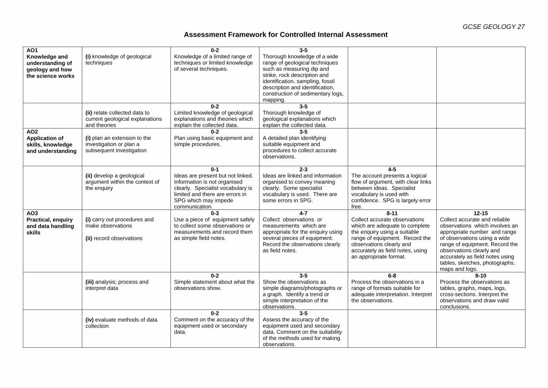
GCSE GEOLOGY 27 Assessment Framework for Controlled Internal Assessment
AO1 Knowledge and understanding of geology and how the science works
(i) knowledge of geological techniques
0-2 Knowledge of a limited range of techniques or limited knowledge of several techniques.
3-5 Thorough knowledge of a wide range of geological techniques such as measuring dip and strike, rock description and identification, sampling, fossil description and identification, construction of sedimentary logs, mapping.
(ii) relate collected data to current geological explanations and theories
0-2 Limited knowledge of geological explanations and theories which explain the collected data.
3-5 Thorough knowledge of geological explanations which explain the collected data.
AO2 Application of skills, knowledge and understanding
(i) plan an extension to the investigation or plan a subsequent investigation
0-2 Plan using basic equipment and simple procedures.
3-5 A detailed plan identifying suitable equipment and procedures to collect accurate observations.
(ii) develop a geological argument within the context of the enquiry
0-1 Ideas are present but not linked. Information is not organised clearly. Specialist vocabulary is limited and there are errors in SPG which may impede communication.
2-3 Ideas are linked and information organised to convey meaning clearly. Some specialist vocabulary is used. There are some errors in SPG.
4-5 The account presents a logical flow of argument, with clear links between ideas. Specialist vocabulary is used with confidence. SPG is largely error free.
AO3 Practical, enquiry and data handling skills
(i) carry out procedures and make observations (ii) record observations
0-3 Use a piece of equipment safely to collect some observations or measurements and record them as simple field notes.
4-7 Collect observations or measurements which are appropriate for the enquiry using several pieces of equipment. Record the observations clearly as field notes.
8-11 Collect accurate observations which are adequate to complete the enquiry using a suitable range of equipment. Record the observations clearly and accurately as field notes, using an appropriate format.
12-15 Collect accurate and reliable observations which involves an appropriate number and range of observations using a wide range of equipment. Record the observations clearly and accurately as field notes using tables, sketches, photographs, maps and logs.
(iii) analysis; process and interpret data
0-2 Simple statement about what the observations show.
3-5 Show the observations as simple diagrams/photographs or a graph. Identify a trend or simple interpretation of the observations.
6-8 Process the observations in a range of formats suitable for adequate interpretation. Interpret the observations.
9-10 Process the observations as tables, graphs, maps, logs, cross-sections. Interpret the observations and draw valid conclusions.
(iv) evaluate methods of data collection
0-2 Comment on the accuracy of the equipment used or secondary data.
3-5 Assess the accuracy of the equipment used and secondary data. Comment on the suitability of the methods used for making observations.
GCSE GEOLOGY 28
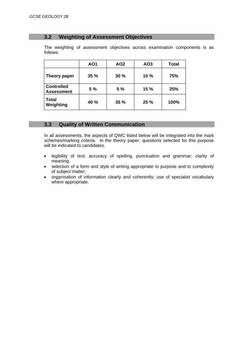
3.2 Weighting of Assessment Objectives
The weighting of assessment objectives across examination components is as follows:
AO1 AO2 AO3 Total
Theory paper
35 %
30 %
10 %
75%
Controlled Assessment 5 % 5 % 15 % 25%
Total Weighting 40 % 35 % 25 %
100%
3.3 Quality of Written Communication
In all assessments, the aspects of QWC listed below will be integrated into the mark schemes/marking criteria. In the theory paper, questions selected for this purpose will be indicated to candidates. • legibility of text; accuracy of spelling, punctuation and grammar; clarity of
meaning; • selection of a form and style of writing appropriate to purpose and to complexity
of subject matter; • organisation of information clearly and coherently; use of specialist vocabulary
where appropriate.
GCSE GEOLOGY 29
4 AWARDING, REPORTING AND RE-SITTING GCSE qualifications are reported on an eight point scale from A* to G, where A* is
the highest grade. The attainment of pupils who do not succeed in reaching the lowest possible standard to achieve a grade is recorded as U (unclassified) and they do not receive a certificate.
This is a linear specification in which all assessments must be taken at the end of the
course. Where candidates wish to re-sit, external components must be re-taken. The controlled assessment component may also be re-taken according to guidelines given in 'Administration of Controlled Assessment'. Alternatively, the total mark for this component may be carried forward for aggregation with the external components when these are re-taken.
GCSE GEOLOGY 30
5 ADMINISTRATION OF CONTROLLED ASSESSMENT
The scheme of assessment The controlled assessment task is worth 25% of the total marks available for the specification. The regulation of controlled assessment in GCSE Geology is split into three stages:
• task setting; • task taking; • task marking.
For each stage, the regulatory authorities have specified a certain level of control to ensure that the conditions under which the tasks are set, carried out and marked are robust and consistent between centres and Awarding Bodies. These controls will ensure that the assessment is valid, reliable and authenticated with a high degree of confidence.
For both options, the assessment will consist of two parts: Part 1 consists of carrying out relevant tests, making relevant observations and measurements and the recording of these by the construction of appropriate “field notes”. This must be done under supervision and the notes collected in by the teacher at the end of the session. Part 2 consists of writing a report of the investigation using the field notes which are re-issued to candidates at the start of the session. The report must include the processing and analysis of the collected data, evaluation of the methods of data collection and the planning of an extension to the investigation. The report should be no longer than 2000 words. The construction of the report must be done under supervision. The field notes and report must be collected in at the end of the session. For both options, the field notes and report produced by the candidate are assessed by the teacher using the assessment framework given in the specification. Exemplar assessments will be available from WJEC. These will illustrate suitable investigations and the application of the assessment framework. It can be seen from the above that both options have identical levels of control: Task setting - high degree of control The Option 1 task is supplied by WJEC and varied annually. Option 2 tasks chosen by the centre must be approved by WJEC.
GCSE GEOLOGY 31
Task taking - medium/high degree of control Part 1 is carried out under medium control and Part 2 under high control. Each piece of work must be authenticated by the candidate and teacher to be solely that of the named candidate. Task marking - medium degree of control Candidates’ work will be marked by their teacher(s) and the marking will be moderated by WJEC. The marked work of a sample of candidates (field notes and report) and the requisite forms (see appendix) must be submitted to WJEC for moderation of the marking. Internal moderation Centres must ensure that careful cross moderation is carried out where more than one teacher is responsible for the marking of the Controlled Assessment. This is necessary to ensure uniformity of standards within a centre. Where internal moderation is necessary the teacher assuming overall responsibility for this process should provide, for the external moderator, a written outline of the procedures that have been adopted.
Authentication of Controlled Assessments
Each piece of work must be authenticated by the candidate and teacher to be solely that of the named candidate. A copy of the authentication form, which forms part of the cover sheet for each candidate’s work is provided in the Appendix. It is important to note that all candidates are required to sign this form, and not merely those whose work forms part of the sample submitted to the moderator. Malpractice discovered prior to the candidate signing the declaration of authentication need not be reported to WJEC but must be dealt with in accordance with the centre’s internal procedures.
Before any work towards the Controlled Assessment is undertaken, the attention of candidates should be drawn to the relevant JCQ Notice to Candidates. This is available on the JCQ website (www.jcq.org.uk) and included in Instructions for Conducting Coursework/Portfolios. More detailed guidance on the prevention of plagiarism is given in Plagiarism in Examinations; Guidance for Teachers/Assessors also available on the JCQ website.
External moderation
The moderation of teacher assessment will be provided by inspection of the Controlled Assessment by WJEC. Centres will be informed of the submission date for the Controlled Task in the published Examinations Timetable and the name of their moderator will be issued in the spring term prior to the submission date.
As a result of the moderation, the marks of candidates may be adjusted to bring the centre's marks into line with the national standard. The moderation process is assisted considerably if the final marks of all the candidates are submitted to the moderator in rank order. It is only if this is done that the moderator can be fully aware of the impact of any scaling. In the event of concern over the awarding procedures, the normal appeals process will apply.
GCSE GEOLOGY 32
6 GRADE DESCRIPTIONS
Grade descriptions are provided to give a general indication of the standards of achievement likely to have been shown by candidates awarded particular grades. The descriptions must be interpreted in relation to the content specified by the specification; they are not designed to define that content. The grade awarded will depend in practice upon the extent to which the candidate has met the assessment objectives overall. Shortcomings in some aspects of the examination may be balanced by better performances in others. Grade F
Candidates demonstrate a limited knowledge and understanding of geology content and how geology works. They use a limited range of the concepts, techniques and facts from the specification, and demonstrate basic communication and numerical skills, with some limited use of technical terms and techniques. They show some awareness of how geological information is collected and that this information can explain many phenomena. They use and apply their knowledge and understanding of simple principles and concepts in some specific contexts. With help they plan a geological task, such as a practical procedure, testing an idea, answering a question, or solving a problem, using a limited range of information in an uncritical manner. They are aware that decisions have to be made about uses of geological knowledge and, in simple situations familiar to them, identify some of those responsible for the decisions. They describe some benefits and drawbacks of geological developments with which they are familiar and issues related to these. They follow simple instructions for carrying out a practical task and work safely as they do so. Candidates identify simple patterns in data they gather from first-hand and secondary sources. They present evidence as simple tables, charts and graphs, and draw simple conclusions consistent with the evidence they have collected. Grade C
Candidates demonstrate a good overall knowledge and understanding of geology content and how geology works, and of the concepts, techniques, and facts across most of the specification. They demonstrate knowledge of technical vocabulary and techniques, and use these appropriately. They demonstrate communication and numerical skills appropriate to most situations. They demonstrate an awareness of how geological evidence is collected and are aware that geological knowledge and theories can be changed by new evidence. Candidates use and apply scientific knowledge and understanding in some general situations. They use this knowledge, together with information from other sources, to help plan a geology task, such as a practical procedure, testing an idea, answering a question, or solving a problem.

GCSE GEOLOGY 33
They describe how, and why, decisions about uses of geological knowledge are made in some familiar contexts. They demonstrate good understanding of the benefits and risks of geological advances, and identify ethical issues related to these. They carry out practical tasks safely and competently, using equipment appropriately and making relevant observations, appropriate to the task. They use appropriate methods for collecting first-hand and secondary data, interpret the data appropriately, and undertake some evaluation of their methods. Candidates present data in ways appropriate to the context. They draw conclusions consistent with the evidence they have collected and evaluate how strongly their evidence supports these conclusions. Grade A
Candidates demonstrate a detailed knowledge and understanding of geology content and how geology works, encompassing the principal concepts, techniques, and facts across all areas of the specification. They use technical vocabulary and techniques with fluency, clearly demonstrating communication and numerical skills appropriate to a range of situations. They demonstrate a good understanding of the relationships between data, evidence and geological explanations and theories. They are aware of areas of uncertainty in geological knowledge and explain how geological theories can be changed by new evidence. Candidates use and apply their knowledge and understanding in a range of tasks and situations. They use this knowledge, together with information from other sources, effectively in planning a geological task, such as a practical procedure, testing an idea, answering a question, or solving a problem. Candidates describe how, and why, decisions about uses of geological knowledge are made in contexts familiar to them, and apply this knowledge to unfamiliar situations. They demonstrate good understanding of the benefits and risks of geological advances, and identify ethical issues related to these. They choose appropriate methods for collecting first-hand and secondary data, interpret and question data skilfully, and evaluate the methods they use. They carry out a range of practical tasks safely and skilfully, selecting and using equipment appropriately to make relevant and precise observations. Candidates select a method of presenting data appropriate to the task. They draw and justify conclusions consistent with the evidence they have collected and suggest improvements to the methods used that would enable them to collect more valid and reliable evidence.
GCSE GEOLOGY 34
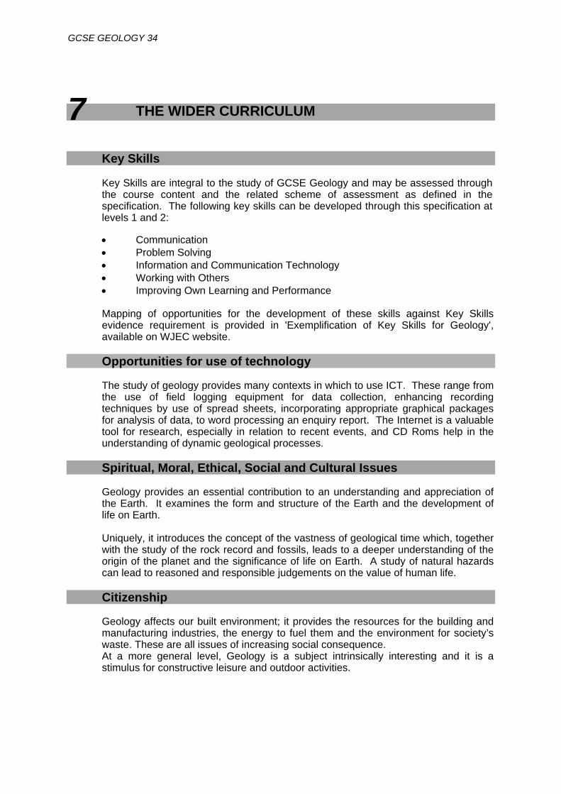
7 THE WIDER CURRICULUM Key Skills Key Skills are integral to the study of GCSE Geology and may be assessed through
the course content and the related scheme of assessment as defined in the specification. The following key skills can be developed through this specification at levels 1 and 2:
• Communication • Problem Solving • Information and Communication Technology • Working with Others
• Improving Own Learning and Performance Mapping of opportunities for the development of these skills against Key Skills
evidence requirement is provided in 'Exemplification of Key Skills for Geology', available on WJEC website.
Opportunities for use of technology The study of geology provides many contexts in which to use ICT. These range from the use of field logging equipment for data collection, enhancing recording techniques by use of spread sheets, incorporating appropriate graphical packages for analysis of data, to word processing an enquiry report. The Internet is a valuable tool for research, especially in relation to recent events, and CD Roms help in the understanding of dynamic geological processes.
Spiritual, Moral, Ethical, Social and Cultural Issues
Geology provides an essential contribution to an understanding and appreciation of
the Earth. It examines the form and structure of the Earth and the development of life on Earth.
Uniquely, it introduces the concept of the vastness of geological time which, together
with the study of the rock record and fossils, leads to a deeper understanding of the origin of the planet and the significance of life on Earth. A study of natural hazards can lead to reasoned and responsible judgements on the value of human life.
Citizenship Geology affects our built environment; it provides the resources for the building and
manufacturing industries, the energy to fuel them and the environment for society’s waste. These are all issues of increasing social consequence.
At a more general level, Geology is a subject intrinsically interesting and it is a stimulus for constructive leisure and outdoor activities.

GCSE GEOLOGY 35
Environmental Issues The study of natural phenomena, such as earthquakes and volcanoes, and of
scenery evolving under the influence of geological forces, encourages a deep appreciation of the natural world together with an awareness of individual and societal attitudes, values and actions in response to natural environmental issues.
The specification content has sections on global warming and the conservation of important rock exposures.
Health and Safety Consideration
Safety is paramount both in the field and the 'laboratory' and it is essential that all Centres adhere to 'The Geological Code of Conduct' and the regulations of their Centre concerning off-site activities. Students are requested to devise a risk assessment of their Geological Enquiry as part of their 'Planning'.
The European Dimension
Relevant examples are chosen by the teacher/student to illustrate geological concepts. This will have a global, European and/or national context, e.g., earthquake and volcanic zones, mountain belts.

GCSE GEOLOGY 37
APPENDIX

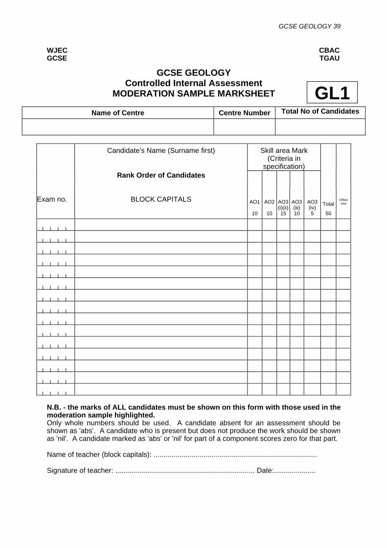
GCSE GEOLOGY 39
WJEC CBAC GCSE TGAU
GCSE GEOLOGY Controlled Internal Assessment
MODERATION SAMPLE MARKSHEET
Name of Centre Centre Number Total No of Candidates
Candidate's Name (Surname first)
Skill area Mark
(Criteria in specification)
Rank Order of Candidates
Exam no.
BLOCK CAPITALS
AO1
AO2
AO3 (i)(ii)
AO3 (iii)
AO3 (iv)
Total
Office Use
10 10 15 10 5 50
N.B. - the marks of ALL candidates must be shown on this form with those used in the moderation sample highlighted. Only whole numbers should be used. A candidate absent for an assessment should be shown as 'abs'. A candidate who is present but does not produce the work should be shown as 'nil'. A candidate marked as 'abs' or 'nil' for part of a component scores zero for that part. Name of teacher (block capitals): .................................................................................. Signature of teacher: ...................................................................... Date:.....................
GL1

GCSE GEOLOGY 41
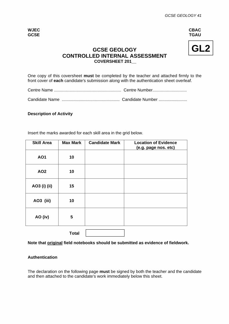
WJEC CBAC GCSE TGAU
GCSE GEOLOGY CONTROLLED INTERNAL ASSESSMENT
COVERSHEET 201__
One copy of this coversheet must be completed by the teacher and attached firmly to the front cover of each candidate's submission along with the authentication sheet overleaf. Centre Name ......................................................... Centre Number............................. Candidate Name ................................................. Candidate Number ........................ Description of Activity Insert the marks awarded for each skill area in the grid below.
Skill Area Max Mark Candidate Mark Location of Evidence (e.g. page nos. etc)
AO1 10
AO2 10
AO3 (i) (ii)
15
AO3 (iii)
10
AO (iv)
5
Total Note that original field notebooks should be submitted as evidence of fieldwork. Authentication The declaration on the following page must be signed by both the teacher and the candidate and then attached to the candidate's work immediately below this sheet.
GL2

GCSE GEOLOGY 42
NOTICE TO CANDIDATE The work you submit for assessment must be your own. If you copy from someone else, allow another candidate to copy from you, or if you cheat in any other way, you may be disqualified from at least the subject concerned.
Declaration by candidate I have read and understood the Notice to Candidate (above). I have produced the attached work without assistance other than that which my teacher has explained is acceptable within the specification.
Candidate’s signature: ....................................................................................................... Date: .................................
Declaration by teacher I confirm that the candidate’s work was conducted under the conditions laid out by the specification. I have authenticated the candidate’s work and am satisfied that to the best of my knowledge the work produced is solely that of the candidate. Teacher’s signature: ............................................................................................................ Date: .................................. GCSE Geology Specification (2011)/JD 26 January 2010