Embed Size (px)
Citation preview
ABSTRACT
High-resolution seismic reflection profiles andwell data from the western Snake River plain basinare used to identify a buried lacustrine delta systemwithin Neogene Idaho Group sediments near Cald-well, Idaho. The delta system is detected, 305 m(1000 ft) deep, near the center of the basin byprogradational clinoform reflections having dips of2–5°, a slope typical of prodelta surfaces of modernlacustrine delta systems. The prodelta slope relief,corrected for compaction, indicates the delta systemprograded northwestward into a lake basin 255 m(837 ft) deep. Resistivity logs in the prodelta mudand clay facies are characterized by gradual upwardincrease in resistivity and grain size over a thicknessof about 100 m (300 ft). Lithology of the prodelta ismostly calcareous claystone, with several layers offine sand, some of which fine upward, indicating adensity-flow mechanism of transport and deposition.Delta-plain and front sediments are mostly very fine-grained, well-sorted sand separated by thin mud lay-ers. These sediments produce several to five cyclesof horizontal, high-amplitude reflections with atoplap relationship to prodelta clinoforms. The sandshave an abrupt lower contact with prodelta mudsand have high resistivity on logs. In this study, per-meable lacustrine sands within a predominantly mudand clay section are located by using high-resolutionseismic reflection data.
Identification of a delta system in the Idaho Group
provides insight into the history of Pliocene “LakeIdaho.” The present depth of the delta/prodelta faciescontact of 305 m (1000 ft) is 445 to 575 m (1460–1900ft) below the lake deposits on the margins. Estimatedsubsidence from compaction is 220 m (656 ft), andthe remaining 225 to 325 m (740–1066 ft) is attributedto tectonic downwarping and faulting.
The original lake area had been reduced to onethird of the original 13,000 km2 (5000 mi2) by thetime the delta front prograded to the Caldwell area.The original lake area may have been sufficient toevaporate most of the inflow, and the lake may haveonly occasionally spilled into other basins. Dimin-ished area for evaporation later in the history of thelake, combined with reduced evaporation accompa-nying onset of the ice ages, may have caused thelake to rise and overtop a basin sill about 2 Ma, andsubsequently deepen Hells Canyon.
INTRODUCTION
Lacustrine deposits in rift basin environments havebecome major petroleum exploration targets in manyparts of the world (Katz, 1990). Likewise, importantgroundwater resources are exploration targets inlacustrine sediments. Exploration methods are neededto identify facies of permeable strata within thick sec-tions of impermeable mud rocks characteristic oflacustrine deposits because these permeable stratamay be hydrocarbon reservoirs or freshwater aquifers.Recognition of clastic depositional systems and per-meable facies on seismic reflection sections in themarine environment has been advanced by the workof Mitchum et al. (1977), Sangree and Widmier (1977),and Berg (1982). This study illustrates the seismicexpression and well-log character of a fine-sand deltafacies within lacustrine clay and mud deposits of theNeogene western Snake River plain, and compares itsgeometry with lacustrine deltas studied elsewhere inthe world.
With the exception of a study of the PaleoceneFort Union Formation of Wyoming by Liro and Par-dus (1990) and Quaternary Lake Biwa, Japan (Ikawa,
102
©Copyright 1994. The American Association of Petroleum Geologists. Allrights reserved.
1Manuscript received, April 8, 1991; revised manuscript received, May13, 1993; final acceptance, August 11, 1993.
2Department of Geosciences, Boise State University, Boise, Idaho 83725This study was made possible through the donation of seismic data to
Boise State University by David Hawk. His continued help andencouragement in this study is greatly appreciated. J. K. Applegate providedinformation on the original acquisition and processing of the data. The authorthanks Ed Squires of Boise State University, employees of J. R. Simplot Co.,Vaughn Thomas Drilling Co., and COLOG, Inc. for their help in acquiringdrilling, logging, and production data, and John Armentrout for a most helpfulreview of the manuscript. This study was partly supported by Idaho StateBoard of Education Grant 91-099, Center for Geophysical Investigation of theShallow Subsurface Contribution 0024.
Seismic Expression and Geological Significance of aLacustrine Delta in Neogene Deposits of the WesternSnake River Plain, Idaho1
Spencer H. Wood2
AAPG Bulletin, V. 78, No. 1 (January 1994), P. 102–121.
1991), little has been published that relates seismicstratigraphy of lacustrine deposits to their subsurfacegeology. Most of the literature is concerned withoutcrop-scale features (Fouch and Dean, 1982).Comparison to studies of the seismic expression ofmarine delta systems, particularly the paper by Berg(1982) was most useful for interpretation in the pre-sent study. The few studies of modern lacustrinedeltas cited in Table 1 are helpful in understandingfacies distributions in these environments, butresearch that incorporates shallow subsurface stud-ies to understand the facies geometry of modernlacustrine environments is clearly needed.
REGIONAL SETTING
The western Snake River plain basin is a normal-fault–bounded intermontane basin between thenorthern Rocky Mountains province and the northernBasin and Range extensional province. The plain is
underlain by a sequence of up to 2 km (6000 ft) oflacustrine and fluvial sediment of the Idaho Group(Wood and Anderson, 1981). The history of deposi-tion and facies distributions within this section ofstrata have not been previously studied. High-resolu-tion seismic reflection profiles combined with geo-physical logs and well-site study of cuttings providean opportunity for interpretation of the Neogene sub-surface geology near Caldwell, Idaho (Figures 1, 2).
The western plain basin is a northwest-trendinggraben-form tectonic basin that evolved after volumi-nous rhyolite volcanism (16–9 Ma) on the south sideof the present basin, and after voluminous ColumbiaRiver basalt volcanism (17–14 Ma) on the north side(Leeman, 1989; Wood, 1989a). Tectonic setting of theColumbia River flood basalts is reviewed by Hooperand Conrey (1989). Tectonic setting of the rhyolitesystems has the appearance of a northeast-migratingcontinental hot spot (Armstrong et al., 1975; Rodgerset al., 1990; Pierce and Morgan, 1992). Brott et al.(1981) hypothesized that cooling of the lithosphere
Wood 103
Table 1. Comparison of Settings of Lacustrine Deltas*
River Average Annual[Delta Area] Drainage Annual Suspended AnnualLake Area Area Discharge Load Bedload Basin
(km2) (km2) (109 m3/yr) (106 m3/yr) (106 m3/yr) Origin Latitude
Lake Constance [6+] 6122 6.95 2.57 0.04 Würm-age temperateRhine River 600 glaciated(Bodensee) basinSwitzerland
Pyramid Lake [20] 4785 0.72 0.1 ? tectonic, temperateTruckee River 428 0.26** lake level 40° NNevada, USA lowered,
eroded andrebuilt delta
Lake Laitaure [10] 684 6.3 0.24 0.04 glaciated arcticSweden 9 67°N
Lake Maracaibo [1200] 15,000 29 4.8 broad tropicalCatatumbo River 12,900 tectonic 10°NVenezuela subsidence
Neogene 13,000† 180,000† 16†† 11†† 0.4-1.1†† tectonic, temperateLake Idaho subsidence 44°N(Snake River) & faultingIdaho, USA
*References: Lake Constance = Müller, 1966; Pyramid Lake = Born, 1972; Lake Laitaure = Axelsson, 1967; Lake Maracaibo = Hyne et al., 1979.**Discharge after diversion of the Truckee River for irrigation. Much of the modern delta was built after diversion in the early 20th Century.†Original lake area taken from distribution of Idaho Group sediments. Position of the buried delta discussed in this paper suggests the floodplain occupied
about two thirds of the basin, and the lake about one third or 4300 km2. Discharge of the modern Snake River at Weiser, Idaho, 70-year average (fromKjelstrom, 1986).
††Sediment loads measured at Lewiston, Idaho are the only available measurements (from Seitz, 1976). Bedload (>0.2mm caught in bed-load sampler)ranges from 5 to 10% of the suspended load. This reach of the river is below Hells Canyon, and the river is impounded by a series of hydroelectric damsabout 100 km above here; therefore, these measurements may not be representative of sediment load in Neogene time.
after passage of the hot spot produced the downwarpstructure of the eastern Snake River plain. Althoughthe eastern and western parts of the Snake River plainform a continuous physiographic lowland, the easternplain is a southwest-trending downwarp withoutmajor fault boundaries, whereas the northwest-trend-ing western plain is clearly a graben form with normalfault boundaries. The fault boundaries parallel otherextensional features that formed perpendicularly tothe hot spot track.
Middle Miocene volcanic rocks form an acousticbasement about 2 km beneath the deepest part of thewestern plain basin (Figure 3). Sporadic olivine-tholeiite basalt volcanism has continued through theNeogene and Quaternary from vents of a north 70°west trending volcanic zone that traverses the west-ern plain, and from vents on the margins (Wood,1989b). Minor amounts of these basalts are intercalat-ed with the sedimentary fill of the western plain. Theeastern plain is largely covered with Pliocene andQuaternary basalts, which erupted from N40°Wtrending volcanic rift zones (Kuntz et al., 1992), withaccumulations that are locally 1000 m (3280 ft) thick.
Because of its large size and graben structure thewestern plain basin has been called a tectonic conti-nental rift. The western plain basin meets the defini-tion of a tectonic rift in that it is a “long, narrow conti-nental trough that is bounded by normal faults, agraben of regional extent” (Bates and Jackson, 1980).The structural geometry is similar to other continentalrift basins described by Bosworth (1985). The buriedhorst block in the center (Figure 3) is interpreted tobe an interbasinal ridge or an extension transfer zone(using terminologies of Rosendahl et al., 1986; Morleyet al., 1990) between half-graben structures formedduring early basin evolution. Areal extent of the horstis indicated by a +20 mGal gravity anomaly outlinedby the dotted line in Figure 3. Structural dip of themargin fault blocks and infilling sediment toward thecenter of the basin suggest the lithosphere has morerecently undergone extension and necking that createnegative buoyancy of the basin, and broad subsi-dence of the center of the basin in a manner suggest-ed by Braun and Beaumont (1989). Some compo-nents of the dip of the sediments and subsidence ofthe center of the basin, however, are because of com-
104 Snake River Plain, Idaho
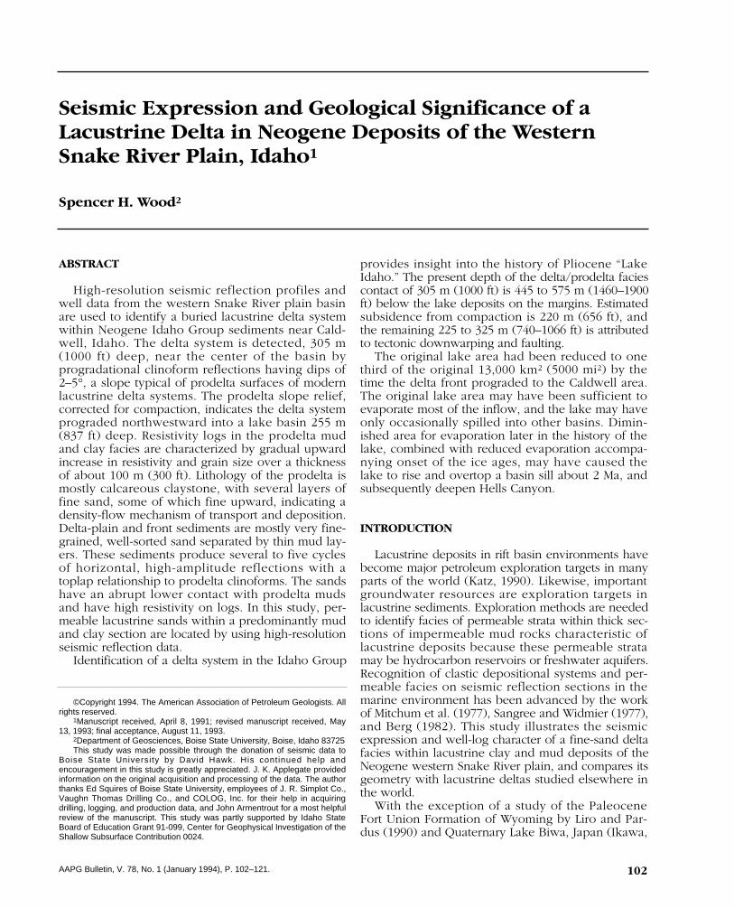
Figure 1—Index map showing distribution of Neogene Idaho Group lacustrine deposits in the western Snake Riverplain, location of physiographic features and drainages influencing the Neogene lakes that occupied the westernplain region, and distribution of Columbia River basalt, shown by dotted line. Accumulation of Columbia Riverbasalt in the early Neogene and subsequent broad uplift of the Blue Mountains and Wallowa–Seven Devils Moun-tains formed a barrier to northern drainage of the Snake River system. Outlet of the lake system may have beensouthwest through Harney Basin. Other workers have suggested connection to the Klamath River system of north-ern California. AA' is location of cross section shown in Figure 3.
paction of the thick accumulation of fine sediment inthe center of the basin.
The basin contained large freshwater lakes andriver systems from about 8.5 to 2.0 Ma and filledwith predominantly fine siliciclastic sediment and
minor intercalated pyroclastic and flow basalt layers.Numerous earlier papers summarized in Wheelerand Cook (1954) and Jenks and Bonnichsen (1989)alluded to a large Pliocene lake in the western plain,commonly referred to as Lake Idaho, but little is
Wood 105
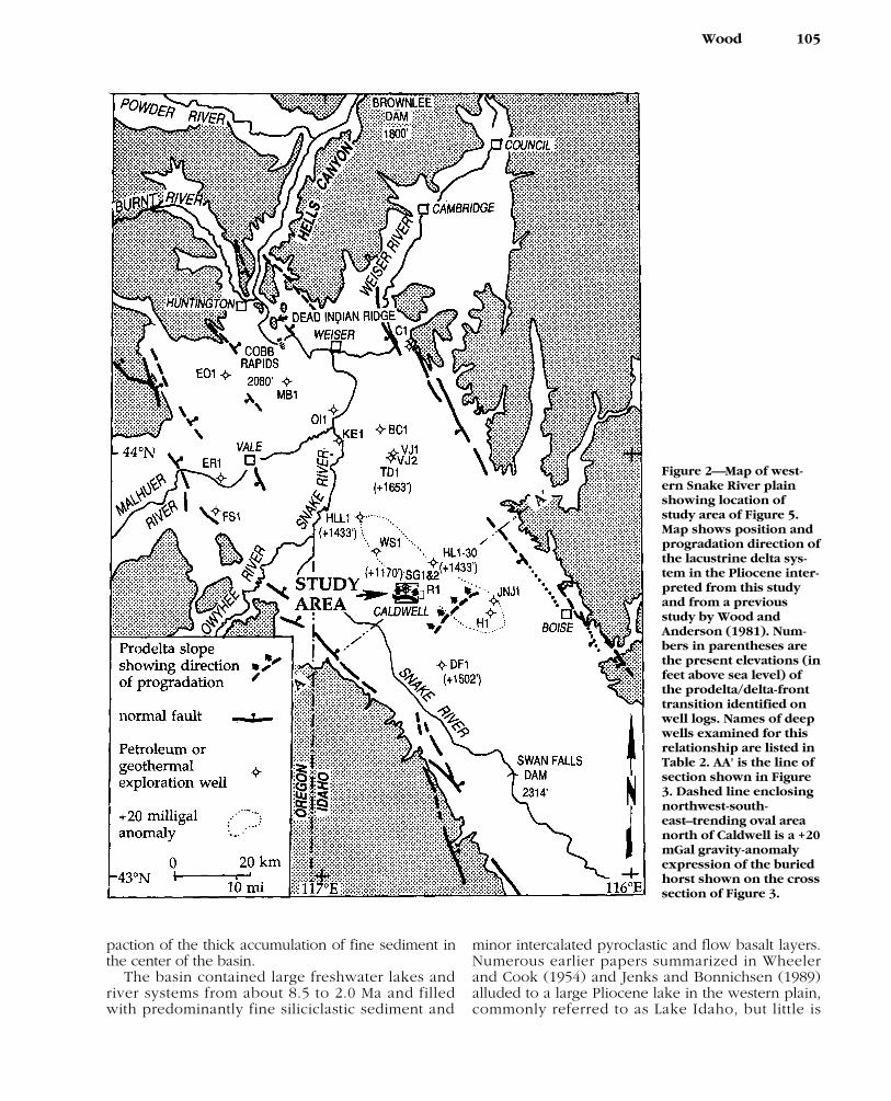
Figure 2—Map of west-ern Snake River plainshowing location ofstudy area of Figure 5.Map shows position andprogradation direction ofthe lacustrine delta sys-tem in the Pliocene inter-preted from this studyand from a previousstudy by Wood andAnderson (1981). Num-bers in parentheses arethe present elevations (infeet above sea level) ofthe prodelta/delta-fronttransition identified onwell logs. Names of deepwells examined for thisrelationship are listed inTable 2. AA' is the line ofsection shown in Figure3. Dashed line enclosingnorthwest-south-east–trending oval areanorth of Caldwell is a +20mGal gravity-anomalyexpression of the buriedhorst shown on the crosssection of Figure 3.
known of the history of lake systems. Discontinuouslacustrine shoreline deposits typically occur up toabout 975 m (3200 ft). Higher deposits such as 1128m (3700 ft) in the foothills on the north side of thebasin (Gallegos et al., 1987) and 1036 m (3400 ft) onthe south side of the basin (Smith et al., 1982) mayhave been elevated by faulting. Although the oldestlake deposits in the graben are clearly downfaultedone or more kilometers from their remnants in themargin foothills, evidence for the highest lake levelsremarkably occurs on both sides of the basin at simi-lar elevations (1000 ± 130 m). These elevations sug-gest relatively little differential vertical movement ofthe basin margins since the last high-lake level.Apparently, the graben subsided by downwarpingand minor normal faulting, with minor flank upliftduring the late Neogene and Quaternary.
At its maximum extent, the sedimentary basin cov-ered about 13,000 km2, judging from distribution ofthick, fine-grained sediments and shoreline deposits(Figure 1). The drainage basin delivering water to thelake may have been similar in size to the presentupper Snake River catchment (above Weiser, Idaho),which is 175,000 km2. Some have speculated that inthe Neogene the lake basin drained through south-eastern Oregon to the Klamath River system in north-ern California (Figure 1) (Wheeler and Cook, 1954;Taylor, 1960, 1985; Smith, 1975; Smith et al., 1982).Physical evidence for such an outlet through theGreat Basin has not been found; the evidence ismainly paleozoological affinities of fossil mollusks
and fish in lacustrine deposits of the western plain(Smith, 1981). Wheeler and Cook (1954) proposedthat the downcutting of ancestral Hells Canyonthrough the Blue Mountains and the Wallowa–SevenDevils structural arches caused capture of the SnakeRiver basin by the Columbia River drainage system.Surficial deposits of fluvial gravel deposited over thelake sediments mark the conversion of the basinfrom an aggrading lacustrine and fluvial basin to aneroding stream system (Malde, 1991; Othberg, 1992;Othberg and Sanford, 1992). This enormous diver-sion of Snake River basin waters caused furtherdowncutting of Hells Canyon, now the deepest gorgein North America. The Snake River is now incising itslacustrine deposits in the western plain basin.
STRATIGRAPHY OF BASIN FILL
Stratigraphy of the basin fill has been developedfrom the study of dissected deposits, mostly on thesouthwest margin of the plain. A diagram of litho-stratigraphic units published by Malde and Powers(1962) is shown in Figure 4. Much of the mud, silt,and clay in the upper 1000 m of the basin fill couldbe called mudrock, mudstone, siltstone, and clay-stone, because, in a geological sense, they are most-ly soft friable rocks. In a geotechnical sense thesematerials fall to both sides of the definition of rock[unconfined compressive strengths above 1500kN/m2 (200 psi); in other words, materials that can-
106 Snake River Plain, Idaho
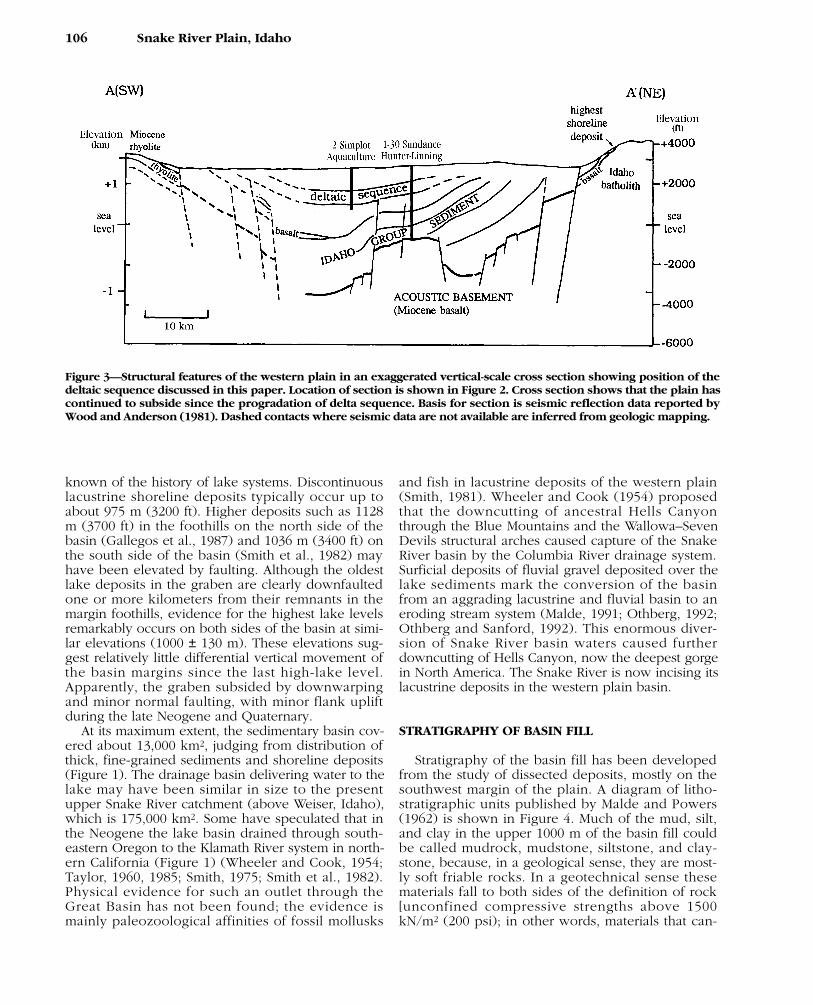
Figure 3—Structural features of the western plain in an exaggerated vertical-scale cross section showing position of thedeltaic sequence discussed in this paper. Location of section is shown in Figure 2. Cross section shows that the plain hascontinued to subside since the progradation of delta sequence. Basis for section is seismic reflection data reported byWood and Anderson (1981). Dashed contacts where seismic data are not available are inferred from geologic mapping.
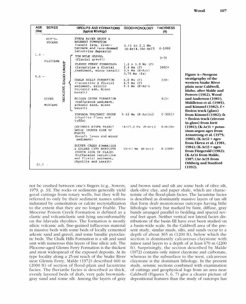
not be crushed between one’s fingers (e.g., Sowers,1979, p. 3)]. The rocks or sediments generally yieldgood cuttings from rotary wells, but they will bereferred to only by their sediment names unlessindurated by cementation or calcite recrystallizationto the extent that they are no longer friable. TheMiocene Poison Creek Formation is defined as aclastic and volcaniclastic unit lying unconformablyon the Idavada rhyolites. The formation is mostlysilicic volcanic ash, fine-grained tuffaceous materialin massive beds with some beds of locally cementedarkosic sand and gravel, and some basaltic pyroclas-tic beds. The Chalk Hills Formation is a silt and sandunit with numerous thin layers of fine silicic ash. ThePliocene-aged Glenns Ferry Formation is the thickestand most widespread of the exposed deposits. At itstype locality along a 25-mi reach of the Snake Rivernear Glenns Ferry, Malde (1972) described 660 m(2000 ft) of section of flood-plain and lacustrinefacies. The fluviatile facies is described as thick,evenly layered beds of drab, very pale brownish-gray sand and some silt. Among the layers of gray
and brown sand and silt are some beds of olive silt,dark-olive clay, and paper shale, which are charac-teristic of the flood-plain facies. The lacustrine faciesis described as dominantly massive layers of tan siltthat form drab monotonous outcrops having littlelithologic variety but marked by faint, diffuse, graybands arranged parallel to bedding and spaced sev-eral feet apart. Neither vertical nor lateral facies dis-tributions of the basin fill have ever been studied ona basin-wide scale. In the Caldwell area of the pre-sent study, similar muds, silts, and sands occur to adepth of about 365 m (1200 ft), below which thesection is dominantly calcareous claystone withminor sand layers to a depth of at least 670 m (2200ft). Surprisingly, the section described by Malde(1972) contains only minor claystone and carbonate,whereas in the subsurface to the west, calcareousclaystone is the dominant lithology. In the presentstudy, seismic sections combined with examinationof cuttings and geophysical logs from an area nearCaldwell (Figures 5, 6, 7) give a clearer picture ofdepositional features than the study of outcrops has
Wood 107
Figure 4—Neogenestratigraphy of thewestern Snake Riverplain near Caldwell,Idaho, after Malde andPowers (1962), Woodand Anderson (1981),Middleton et al. (1985),and Kimmel (1982). f =fission track (glass)from Kimmel (1982); fz= fission track (zirconsin glass) from Izett(1981); (K-Ar)1 = potas-sium-argon ages fromArmstrong et al. (1975;1980), (K-Ar)2 = agesfrom Ekren et al. (1981,1984); (K-Ar)3 = agesfrom Fitzgerald (1982);(K-Ar)4 from Malde,1987; (Ar-Ar)5 fromOthberg and Stanford(1992).
given. In particular, a large northwestward-prograd-ing delta system is identified in the subsurface, about305 m (1000 ft) deep beneath the middle of the plainnear Caldwell, Idaho.
PETROLEUM AND GEOTHERMAL EXPLORATIONRESULTS
A number of petroleum and geothermal explo-ration wells (Table 2) have drilled the Neogenelacustrine deposits and the deeper Miocene volcanicand sedimentary rock beneath the western SnakeRiver plain (Figure 2). Earlier results are reviewed byKirkham (1935) and Newton and Corcoran (1963),and geothermal aspects of recent drilling have beenreviewed by Wood and Anderson (1981) and Black-well (1989). Many early wells had hydrocarbon gasshows in the sandy strata. Several uncontrolledblowouts and gushers either sanded up or depletedgas in the reservoir within a few days (Kirkham,1935). Controlled formation tests in several wellsdrilled since 1950 produced low flows (50–350mcf/day), but these flows also dwindled within afew days or less (Newton and Corcoran, 1963).
Sanyal et al. (1980) and GeothermEx, Inc. (1980)report significant gas on the mud log of the Ore-IdaFoods 1 Ore-Ida well from the section above 2195 m(7200 ft). Possible high-gas saturation from the inter-val 2106 –2137 m (6910–7010 ft) is interpreted fromgeophysical logs by Sanyal et al. (1980). No produc-tion has been established in the basin, and as Dea-con and Benson (1971) concluded, test results thusfar indicate low-volume reservoirs of gas.
Dry cuttings samples from the deepest wildcatwell (Halbouty-Chevron 1 J. N. James) were studiedby Geochem Laboratories, Inc. (unpublished data)for prospective source rocks. Ten sample intervals offine sediment having the highest total organic carboncontent ranging from 0.43 to 1.95% were examined.Organic matter type in the kerogen concentrate ispredominantly woody material with secondaryamounts of herbaceous spore pollen and tertiaryinertinite, indicating the sediments are potentialsource rocks for gas but not for liquid hydrocarbons.Samples from 300 to 640 m (1000–2100 ft) (PlioceneIdaho Group sediments) are considered thermallyimmature based on the greenish light-yellow toorange-brown coloration of recognizable plant cuti-cle contained in the kerogen concentrate. Samples
108 Snake River Plain, Idaho
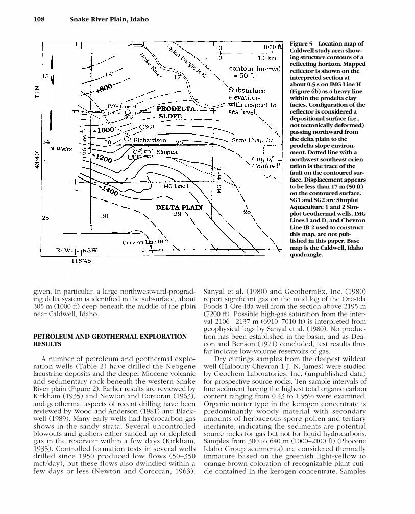
Figure 5—Location map ofCaldwell study area show-ing structure contours of areflecting horizon. Mappedreflector is shown on theinterpreted section atabout 0.5 s on IMG Line H(Figure 6b) as a heavy linewithin the prodelta clayfacies. Configuration of thereflector is considered adepositional surface (i.e.,not tectonically deformed)passing northward fromthe delta plain to theprodelta slope environ-ment. Dotted line with anorthwest-southeast orien-tation is the trace of thefault on the contoured sur-face. Displacement appearsto be less than 17 m (50 ft)on the contoured surface.SG1 and SG2 are SimplotAquaculture 1 and 2 Sim-plot Geothermal wells. IMGLines I and D, and ChevronLine IB-2 used to constructthis map, are not pub-lished in this paper. Basemap is the Caldwell, Idahoquadrangle.
from the interval 1170–2650 m (3840–8700 ft) (sedi-ments from below the acoustic basement interfaceshown in Figure 3) are interpreted as thermallymature based on orange-brown to dark-brown col-oration of recognizable plant cuticle kerogen (stage2+ to 3 alteration). Only two wells (Halbouty-Chevron 1 J. N. James and Champlin Petroleum 1Deer Flat) have penetrated this deeper section. Ques-tionable solid hydrocarbon material was found in theHalbouty-Chevron 1 J. N. James well, and successfuldrill-stem testing could not be done on the prospec-tive zones in the Champlin Petroleum 1 Deer Flatwell.
Geothermal gradients in the western plain basinare relatively high, ranging from 30 to 40°C/km(16.5–22°F/1000 ft) (Wood and Anderson, 1981;Blackwell, 1989). Several exploratory wells weredrilled for geothermal water in the 1980s (Table 2),but significant water production has been 74°C(165°F) or less. The present study is based on datafrom a geothermal aquaculture project.
In the study area near Caldwell, Idaho (Figure 5),Oroco Oil and Gas Co. drilled the 1 Richardsonwildcat well in 1955 to a depth of 926 m (3036 ft). Aproduction test of the lower 50-ft interval initiallyflowed methane at 50 mcf/day, but rapidly dwindledto a low flow (Newton and Corcoran, 1963). Thewell currently produces artesian geothermal 40°C(105°F) water that flows at a rate of 3.1 L/s (50gal/min), and has a surface shut-in pressure of 0.17MPa (24 psi). The well is presently obstructed below769 m (2524 ft). A temperature log to that depthshows a temperature of 64°C (148°F), and flow ofgeothermal water entering the well through severalplaces where the casing was broken by explosives.
To support a geothermal aquaculture operation inthe same area, in 1988 the J. R. Simplot Co. complet-ed a 342-m (1120 ft) well (G1 on Figure 5) into afine sand aquifer, with an artesian flow of 39°C(101°F) water at a rate of 25 L/s (400 gal/min) and ashut-in well-head pressure of 0.22 MPa (32.5 psi). In1989 a second well (G2 on Figure 5) was drilled to686 m (2250 ft) to explore the deeper and hottersands indicated on the original logs of the Oroco 1Richardson well, but drilling difficulties preventedcompletion of the well. Examination of rotary cut-tings from these wells now allows lithologies to beassociated with the reflections on the seismic sec-tions and the character of the geophysical logs.
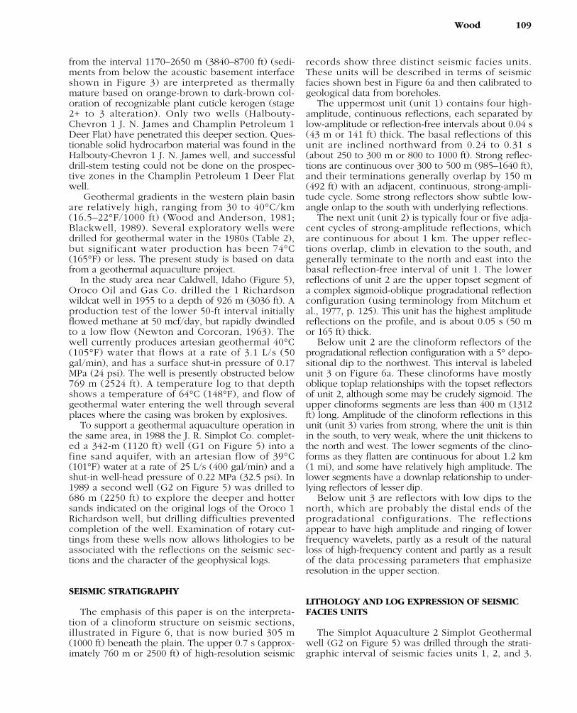
SEISMIC STRATIGRAPHY
The emphasis of this paper is on the interpreta-tion of a clinoform structure on seismic sections,illustrated in Figure 6, that is now buried 305 m(1000 ft) beneath the plain. The upper 0.7 s (approx-imately 760 m or 2500 ft) of high-resolution seismic
records show three distinct seismic facies units.These units will be described in terms of seismicfacies shown best in Figure 6a and then calibrated togeological data from boreholes.
The uppermost unit (unit 1) contains four high-amplitude, continuous reflections, each separated bylow-amplitude or reflection-free intervals about 0.04 s(43 m or 141 ft) thick. The basal reflections of thisunit are inclined northward from 0.24 to 0.31 s(about 250 to 300 m or 800 to 1000 ft). Strong reflec-tions are continuous over 300 to 500 m (985–1640 ft),and their terminations generally overlap by 150 m(492 ft) with an adjacent, continuous, strong-ampli-tude cycle. Some strong reflectors show subtle low-angle onlap to the south with underlying reflections.
The next unit (unit 2) is typically four or five adja-cent cycles of strong-amplitude reflections, whichare continuous for about 1 km. The upper reflec-tions overlap, climb in elevation to the south, andgenerally terminate to the north and east into thebasal reflection-free interval of unit 1. The lowerreflections of unit 2 are the upper topset segment ofa complex sigmoid-oblique progradational reflectionconfiguration (using terminology from Mitchum etal., 1977, p. 125). This unit has the highest amplitudereflections on the profile, and is about 0.05 s (50 mor 165 ft) thick.
Below unit 2 are the clinoform reflectors of theprogradational reflection configuration with a 5° depo-sitional dip to the northwest. This interval is labeledunit 3 on Figure 6a. These clinoforms have mostlyoblique toplap relationships with the topset reflectorsof unit 2, although some may be crudely sigmoid. Theupper clinoforms segments are less than 400 m (1312ft) long. Amplitude of the clinoform reflections in thisunit (unit 3) varies from strong, where the unit is thinin the south, to very weak, where the unit thickens tothe north and west. The lower segments of the clino-forms as they flatten are continuous for about 1.2 km(1 mi), and some have relatively high amplitude. Thelower segments have a downlap relationship to under-lying reflectors of lesser dip.
Below unit 3 are reflectors with low dips to thenorth, which are probably the distal ends of theprogradational configurations. The reflectionsappear to have high amplitude and ringing of lowerfrequency wavelets, partly as a result of the naturalloss of high-frequency content and partly as a resultof the data processing parameters that emphasizeresolution in the upper section.
LITHOLOGY AND LOG EXPRESSION OF SEISMICFACIES UNITS
The Simplot Aquaculture 2 Simplot Geothermalwell (G2 on Figure 5) was drilled through the strati-graphic interval of seismic facies units 1, 2, and 3.
Wood 109
110 Snake River Plain, Idaho
Figure 6—High-resolution seismic sections of IMG lines B and H (unmigrated). Location of lines shown in Figure 5. Datumis 762 m (2500 ft) above sea level. Elevation of ground level along lines is between 707 and 728 m (2320 and 2390 ft).
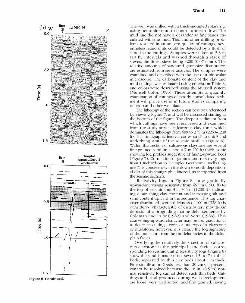
The well was drilled with a truck-mounted rotary rig,using bentonite mud to control artesian flow. Themud line did not have a desander so fine sands cir-culated with the mud. This and other drilling prob-lems resulted in an uneven quality of cuttings; nev-ertheless, sand units could be detected by a flush ofsand in the cuttings. Samples were taken at 3.3 m(10 ft) intervals and washed through a stack ofsieves, the finest sieve being #200 (0.074 mm). Therelative amounts of sand and grain-size distributionare estimated from sieve analysis. The samples wereexamined and described with the use of a binocularmicroscope. The carbonate content of the clay andmud cuttings was estimated using criteria on Table 3,and colors were described using the Munsell system(Munsell Color, 1990). These attempts to quantifyexamination of cuttings of poorly consolidated sedi-ment will prove useful in future studies comparingoutcrop and other well data.
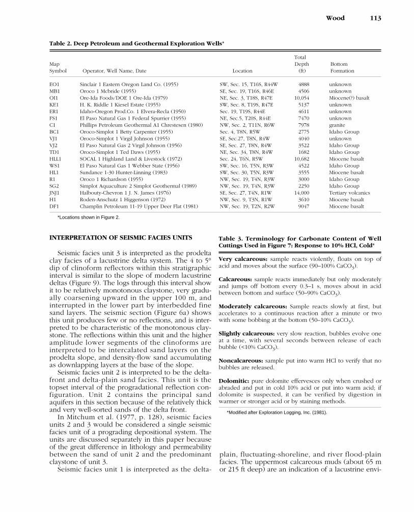
The lithology of the section can best be understoodby viewing Figure 7, and will be discussed starting atthe bottom of the figure. The deepest sediment fromwhich cuttings have been recovered and examinedfrom the study area is calcareous claystone, whichdominates the lithology from 689 to 375 m (2250–1230ft). This stratigraphic interval corresponds to unit 3 andunderlying strata of the seismic profiles (Figure 6).Within this section of calcareous claystone are severalfine-grained sand units about 7 m (20 ft) thick, someshowing log profiles suggestive of fining-upward beds(Figure 7). Correlation of gamma and resistivity logsfrom 1 Richardson to 2 Simplot Geothermal wells (Fig-ure 7) is consistent with the down-to-north deposition-al dip of this stratigraphic interval, as interpreted fromthe seismic sections.
Resistivity logs in Figure 8 show graduallyupward-increasing resistivity from 457 m (1500 ft) tothe top of seismic unit 3 at 366 m (1200 ft), indicat-ing diminishing clay content and increasing silt andsand content upward in the sequence. This log char-acter distributed over a thickness of 100 m (328 ft) isconsidered characteristic of distributary mouth-bardeposits of a prograding marine delta sequence byColeman and Prior (1982) and Serra (1986). Thiscoarsening-upward character may be too gradationalto detect in cuttings, core, or outcrop of a claystoneor mudstone; however, it is clearly the log signatureof the transition from the prodelta facies to the delta-plain facies.
Overlying the relatively thick section of calcare-ous claystone is the principal sand facies, corre-sponding to seismic unit 2. Resistivity logs (Figure 8)show the sand is made up of several 3- to 7-m–thickbeds, separated by thin clay beds about 1 m thick.Fine stratification (beds less than 20 cm), if present,cannot be resolved because the 16 in. (0.5 m) nor-mal resistivity log cannot detect such thin beds. Cut-tings and sand produced during well developmentare loose, very well sorted, and fine grained, having
Wood 111
Figure 6–Continued.
a mean diameter of 0.1 mm (φ = 1, with one stan-dard deviation of 0.5φ). Log profiles are interpretedas both massive beds and beds that coarsen(become less silty) upward. The logs show thatsands are separated by thin clay beds. The SimplotAquaculture 1 Simplot Geothermal well was com-pleted with a 6-m screened interval in this sand.Pump testing of this 6-m section indicated ahydraulic conductivity of the screened section of 12m/day, equivalent to a permeability of 1.0 d.
Between 457 m (1200 ft) and 107 m (350 ft), thestratigraphic interval corresponding to seismic unit 1,are numerous layers of well-sorted fine sandinterbedded with moderately to slightly calcareousmud. The sand beds are typically 3 to 12 m (10–40ft) thick. Woody and carbonaceous material areabundant in silt cuttings. Above 60 m (200 ft), themudstones are noncalcareous, and the sands aremostly medium grained with some coarse-grainedsands and gravels.
112 Snake River Plain, Idaho
Figure 7—Normal resisitivity and gamma-raylogs of wells and lithologic log from drill cut-tings of Simplot Aquaculture 2 Simplot Geother-mal well. Location of wells shown in Figure 5.Depths are referred to ground level of 710 m(2330 ft). Color names are for dry cuttings,using Munsell soil color charts (Munsell Color,1990). Relative amounts of calcium carbonateare according to Table 3.
INTERPRETATION OF SEISMIC FACIES UNITS
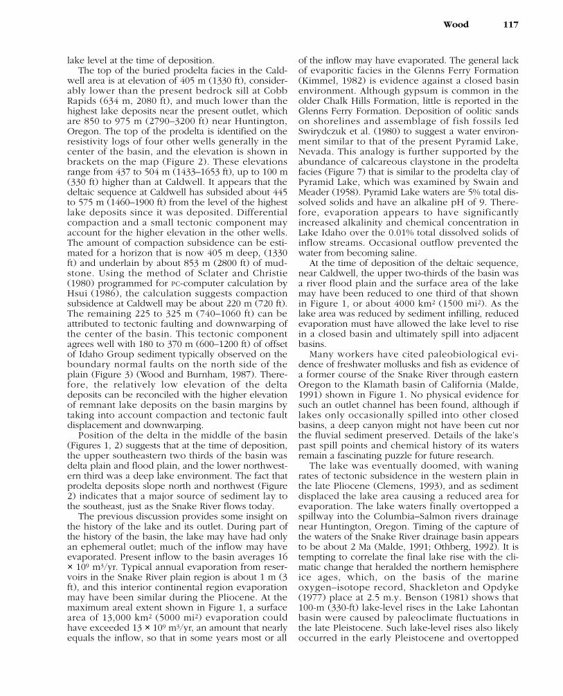
Seismic facies unit 3 is interpreted as the prodeltaclay facies of a lacustrine delta system. The 4 to 5°dip of clinoform reflectors within this stratigraphicinterval is similar to the slope of modern lacustrinedeltas (Figure 9). The logs through this interval showit to be relatively monotonous claystone, very gradu-ally coarsening upward in the upper 100 m, andinterrupted in the lower part by interbedded finesand layers. The seismic section (Figure 6a) showsthis unit produces few or no reflections, and is inter-preted to be characteristic of the monotonous clay-stone. The reflections within this unit and the higheramplitude lower segments of the clinoforms areinterpreted to be intercalated sand layers on theprodelta slope, and density-flow sand accumulatingas downlapping layers at the base of the slope.
Seismic facies unit 2 is interpreted to be the delta-front and delta-plain sand facies. This unit is thetopset interval of the progradational reflection con-figuration. Unit 2 contains the principal sandaquifers in this section because of the relatively thickand very well-sorted sands of the delta front.
In Mitchum et al. (1977, p. 128), seismic faciesunits 2 and 3 would be considered a single seismicfacies unit of a prograding depositional system. Theunits are discussed separately in this paper becauseof the great difference in lithology and permeabilitybetween the sand of unit 2 and the predominantclaystone of unit 3.
Seismic facies unit 1 is interpreted as the delta-
plain, fluctuating-shoreline, and river flood-plainfacies. The uppermost calcareous muds (about 65 mor 215 ft deep) are an indication of a lacustrine envi-
Wood 113
Table 2. Deep Petroleum and Geothermal Exploration Wells*
TotalMap Depth BottomSymbol Operator, Well Name, Date Location (ft) Formation
EO1 Sinclair 1 Eastern Oregon Land Co. (1955) SW, Sec. 15, T16S, R44W 4888 unknownMB1 Oroco 1 Mcbride (1955) SE, Sec. 19, T16S, R46E 4506 unknownOI1 Ore-Ida Foods/DOE 1 Ore-Ida (1979) NE, Sec. 3, T18S, R47E 10,054 Miocene(?) basaltKE1 H. K. Riddle 1 Kiesel Estate (1955) SW, Sec. 8, T19S, R47E 5137 unknownER1 Idaho-Oregon Prod.Co. 1 Elvera-Recla (1950) Sec. 19, T19S, R44E 4611 unknownFS1 El Paso Natural Gas 1 Federal Spurrier (1955) NE, Sec.5, T20S, R44E 7470 unknownC1 Phillips Petroleum Geothermal A1 Chrestesen (1980) NW, Sec. 2, T11N, R6W 7978 graniteBC1 Oroco-Simplot 1 Betty Carpenter (1955) Sec. 4, T8N, R5W 2775 Idaho GroupVJ1 Oroco-Simplot 1 Virgil Johnson (1955) SE, Sec.27, T8N, R4W 4040 unknownVJ2 El Paso Natural Gas 2 Virgil Johnson (1956) SE, Sec. 27, T8N, R4W 3522 Idaho GroupTD1 Oroco-Simplot 1 Ted Daws (1955) NE, Sec. 34, T8N, R4W 1682 Idaho GroupHLL1 SOCAL 1 Highland Land & Livestock (1972) Sec. 24, T6N, R5W 10,682 Miocene basaltWS1 El Paso Natural Gas 1 Webber State (1956) SW, Sec. 16, T5N, R3W 4522 Idaho GroupHL1 Sundance 1-30 Hunter-Linning (1983) SW, Sec. 30, T5N, R3W 3555 Miocene basaltR1 Oroco 1 Richardson (1955) NW, Sec. 19, T4N, R3W 3000 Idaho GroupSG2 Simplot Aquaculture 2 Simplot Geothermal (1989) NW, Sec. 19, T4N, R3W 2250 Idaho GroupJNJ1 Halbouty-Chevron 1 J. N. James (1976) SE, Sec. 27, T4N, R1W 14,000 Tertiary volcanicsH1 Roden-Anschutz 1 Higgenson (1972) NW, Sec. 9, T3N, R1W 3610 Miocene basaltDF1 Champlin Petroleum 11-19 Upper Deer Flat (1981) NW, Sec. 19, T2N, R2W 9047 Miocene basalt
*Locations shown in Figure 2.
Table 3. Terminology for Carbonate Content of WellCuttings Used in Figure 7: Response to 10% HCl, Cold*
Very calcareous: sample reacts violently, floats on top ofacid and moves about the surface (90–100% CaCO3).
Calcareous: sample reacts immediately but only moderatelyand jumps off bottom every 0.3–1 s, moves about in acidbetween bottom and surface (50–90% CaCO3).
Moderately calcareous: Sample reacts slowly at first, butaccelerates to a continuous reaction after a minute or twowith some bobbing at the bottom (50–10% CaCO3).
Slightly calcareous: very slow reaction, bubbles evolve oneat a time, with several seconds between release of eachbubble (<10% CaCO3).
Noncalcareous: sample put into warm HCl to verify that nobubbles are released.
Dolomitic: pure dolomite effervesces only when crushed orabraded and put in cold 10% acid or put into warm acid; ifdolomite is suspected, it can be verified by digestion inwarmer or stronger acid or by staining methods.
*Modified after Exploration Logging, Inc. (1981).
ronment; however, interbedded gravel and coarsesand indicate fluvial systems, and lakeshore environ-ments may have alternated during deposition of thisunit. Abundant woody material in parts of this unitindicates a delta-plain environment, and muds maybe interdelta bays and lagoons.
SLOPE GEOMETRY OF LACUSTRINE DELTAS ANDCLINOFORM REFLECTIONS
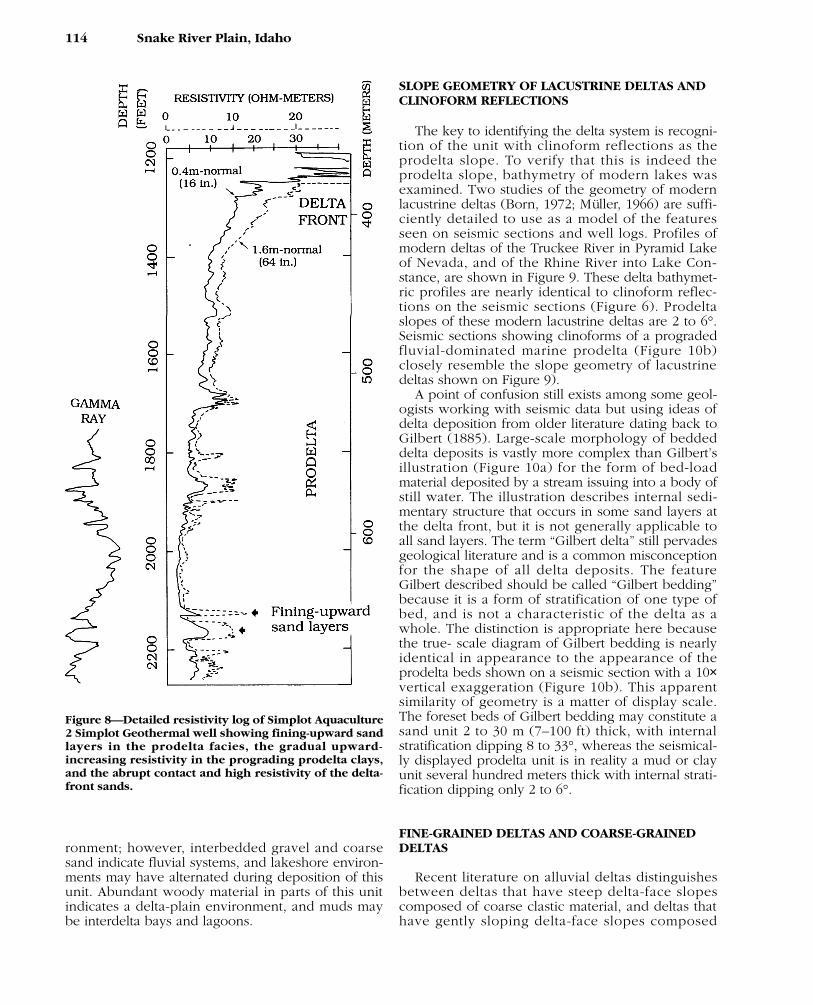
The key to identifying the delta system is recogni-tion of the unit with clinoform reflections as theprodelta slope. To verify that this is indeed theprodelta slope, bathymetry of modern lakes wasexamined. Two studies of the geometry of modernlacustrine deltas (Born, 1972; Müller, 1966) are suffi-ciently detailed to use as a model of the featuresseen on seismic sections and well logs. Profiles ofmodern deltas of the Truckee River in Pyramid Lakeof Nevada, and of the Rhine River into Lake Con-stance, are shown in Figure 9. These delta bathymet-ric profiles are nearly identical to clinoform reflec-tions on the seismic sections (Figure 6). Prodeltaslopes of these modern lacustrine deltas are 2 to 6°.Seismic sections showing clinoforms of a progradedfluvial-dominated marine prodelta (Figure 10b)closely resemble the slope geometry of lacustrinedeltas shown on Figure 9).
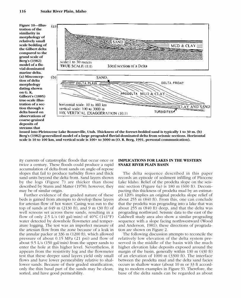
A point of confusion still exists among some geol-ogists working with seismic data but using ideas ofdelta deposition from older literature dating back toGilbert (1885). Large-scale morphology of beddeddelta deposits is vastly more complex than Gilbert’sillustration (Figure 10a) for the form of bed-loadmaterial deposited by a stream issuing into a body ofstill water. The illustration describes internal sedi-mentary structure that occurs in some sand layers atthe delta front, but it is not generally applicable toall sand layers. The term “Gilbert delta” still pervadesgeological literature and is a common misconceptionfor the shape of all delta deposits. The featureGilbert described should be called “Gilbert bedding”because it is a form of stratification of one type ofbed, and is not a characteristic of the delta as awhole. The distinction is appropriate here becausethe true- scale diagram of Gilbert bedding is nearlyidentical in appearance to the appearance of theprodelta beds shown on a seismic section with a 10×vertical exaggeration (Figure 10b). This apparentsimilarity of geometry is a matter of display scale.The foreset beds of Gilbert bedding may constitute asand unit 2 to 30 m (7–100 ft) thick, with internalstratification dipping 8 to 33°, whereas the seismical-ly displayed prodelta unit is in reality a mud or clayunit several hundred meters thick with internal strati-fication dipping only 2 to 6°.
FINE-GRAINED DELTAS AND COARSE-GRAINEDDELTAS
Recent literature on alluvial deltas distinguishesbetween deltas that have steep delta-face slopescomposed of coarse clastic material, and deltas thathave gently sloping delta-face slopes composed
114 Snake River Plain, Idaho
Figure 8—Detailed resistivity log of Simplot Aquaculture2 Simplot Geothermal well showing fining-upward sandlayers in the prodelta facies, the gradual upward-increasing resistivity in the prograding prodelta clays,and the abrupt contact and high resistivity of the delta-front sands.
mostly of fine sand and mud (Nemec, 1990). In the“coarse-grained delta,” gravel and coarse sand bedsare deposited at the delta front; these deposits arecharacteristic of braid deltas and fan deltas (McPher-son et al., 1987). Coarse-grained deposits do notoccur in the delta-front deposits described in thispaper.
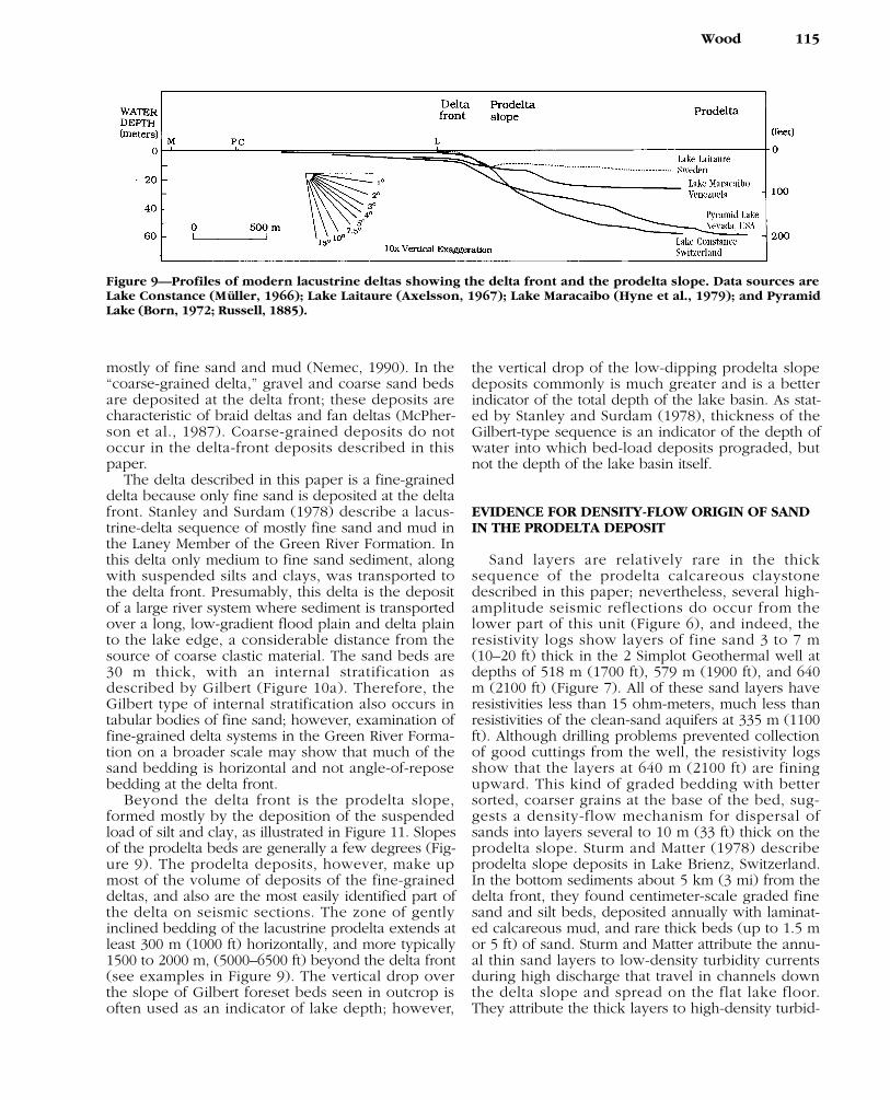
The delta described in this paper is a fine-graineddelta because only fine sand is deposited at the deltafront. Stanley and Surdam (1978) describe a lacus-trine-delta sequence of mostly fine sand and mud inthe Laney Member of the Green River Formation. Inthis delta only medium to fine sand sediment, alongwith suspended silts and clays, was transported tothe delta front. Presumably, this delta is the depositof a large river system where sediment is transportedover a long, low-gradient flood plain and delta plainto the lake edge, a considerable distance from thesource of coarse clastic material. The sand beds are30 m thick, with an internal stratification asdescribed by Gilbert (Figure 10a). Therefore, theGilbert type of internal stratification also occurs intabular bodies of fine sand; however, examination offine-grained delta systems in the Green River Forma-tion on a broader scale may show that much of thesand bedding is horizontal and not angle-of-reposebedding at the delta front.
Beyond the delta front is the prodelta slope,formed mostly by the deposition of the suspendedload of silt and clay, as illustrated in Figure 11. Slopesof the prodelta beds are generally a few degrees (Fig-ure 9). The prodelta deposits, however, make upmost of the volume of deposits of the fine-graineddeltas, and also are the most easily identified part ofthe delta on seismic sections. The zone of gentlyinclined bedding of the lacustrine prodelta extends atleast 300 m (1000 ft) horizontally, and more typically1500 to 2000 m, (5000–6500 ft) beyond the delta front(see examples in Figure 9). The vertical drop overthe slope of Gilbert foreset beds seen in outcrop isoften used as an indicator of lake depth; however,
the vertical drop of the low-dipping prodelta slopedeposits commonly is much greater and is a betterindicator of the total depth of the lake basin. As stat-ed by Stanley and Surdam (1978), thickness of theGilbert-type sequence is an indicator of the depth ofwater into which bed-load deposits prograded, butnot the depth of the lake basin itself.
EVIDENCE FOR DENSITY-FLOW ORIGIN OF SANDIN THE PRODELTA DEPOSIT
Sand layers are relatively rare in the thicksequence of the prodelta calcareous claystonedescribed in this paper; nevertheless, several high-amplitude seismic reflections do occur from thelower part of this unit (Figure 6), and indeed, theresistivity logs show layers of fine sand 3 to 7 m(10–20 ft) thick in the 2 Simplot Geothermal well atdepths of 518 m (1700 ft), 579 m (1900 ft), and 640m (2100 ft) (Figure 7). All of these sand layers haveresistivities less than 15 ohm-meters, much less thanresistivities of the clean-sand aquifers at 335 m (1100ft). Although drilling problems prevented collectionof good cuttings from the well, the resistivity logsshow that the layers at 640 m (2100 ft) are finingupward. This kind of graded bedding with bettersorted, coarser grains at the base of the bed, sug-gests a density-flow mechanism for dispersal ofsands into layers several to 10 m (33 ft) thick on theprodelta slope. Sturm and Matter (1978) describeprodelta slope deposits in Lake Brienz, Switzerland.In the bottom sediments about 5 km (3 mi) from thedelta front, they found centimeter-scale graded finesand and silt beds, deposited annually with laminat-ed calcareous mud, and rare thick beds (up to 1.5 mor 5 ft) of sand. Sturm and Matter attribute the annu-al thin sand layers to low-density turbidity currentsduring high discharge that travel in channels downthe delta slope and spread on the flat lake floor.They attribute the thick layers to high-density turbid-
Wood 115
Figure 9—Profiles of modern lacustrine deltas showing the delta front and the prodelta slope. Data sources areLake Constance (Müller, 1966); Lake Laitaure (Axelsson, 1967); Lake Maracaibo (Hyne et al., 1979); and PyramidLake (Born, 1972; Russell, 1885).
ity currents of catastrophic floods that occur once ortwice a century. These floods could produce a rapidaccumulation of delta-front sands on angle-of-reposeslopes that fail to produce turbidity flows and thicksand units beyond the delta front. Sand layers shownby the logs (Figure 7) are thicker than thosedescribed by Sturm and Matter (1978); however, theymay be of similar origin.
Further evidence of the graded nature of thesebeds is gained from attempts to develop these layersfor artesian flow of hot water. Casing was run to thetop of sands at 649 m (2130 ft), and 9 m (30 ft) ofwell screens set across these sands, resulting in aflow of only 2.5 L/s (40 gal/min) of 40°C (141°F)water detected by downhole flowmeter and temper-ature logging. The test was an imperfect measure ofthe artesian flow from the zone because of a leak inthe annular packer at 336 m (1200 ft), which allowedpressure of about 0.15 MPa (21 psi) and flow ofabout 9.5 L/s (150 gal/min) from the upper sands toenter the hole at this higher level. Nevertheless, itappears from the resistivity log and the flowmetertest that these deeper sand layers yield only smallflows and have lower permeability relative to shal-lower sands. Because of their graded stratification,only the thin basal part of the sands may be clean,sorted, and have good permeability.
IMPLICATIONS FOR LAKES IN THE WESTERNSNAKE RIVER PLAIN BASIN
The delta sequence described in this paperrecords an episode of sediment infilling of PlioceneLake Idaho. Relief of the prodelta slope on the seis-mic section (Figure 6a) is 180 m (600 ft). Decom-pacting this thickness of prodelta mud by an estimat-ed 120% implies an original prodelta slope relief ofabout 255 m (840 ft). From this, one can concludethat the prodelta was prograding into a lake that wasabout 255 m (840 ft) deep, and that the delta wasprograding northward. Seismic data to the east of theCaldwell study area also show a similar progradingsequence with a slope facing northwestward (Woodand Anderson, 1981); these directions of prograda-tion are shown on Figure 2.
The following discussion attempts to reconcile therelatively low elevation of the delta system pre-served in the middle of the basin with the muchhigher elevation lake deposits exposed around themargin of the basin, generally within 130 m (430 ft)of an elevation of 1000 m (3300 ft). The interfacebetween the prodelta mud and the delta sand faciesoccurs in shallow water (about 10 m or 33 ft accord-ing to modern examples in Figure 9). Therefore, thebase of the delta sands can be regarded as about
116 Snake River Plain, Idaho
Figure 10—Illus-tration of thesimilarity inmorphology ofrelatively smallscale bedding ofthe Gilbert deltacompared to thegrand scale ofBerg’s (1982)model of a flu-vial-dominatedmarine delta.(a) Misconcep-tion of deltamorphologydating shownon G. K.Gilbert’s (1885)true-scale illus-tration of a sec-tion through adelta based onobservations ofcoarse-graineddeposits ofstreams thatissued into Pleistocene Lake Bonneville, Utah. Thickness of the foreset-bedded sand is typically 1 to 30 m. (b)Berg’s (1982) generalized model of a large prograded fluvial-dominated delta from seismic sections. Horizontalscale is 10 to 100 km, and vertical scale is 100+ to 3000 m (O. R. Berg, 1991, personal communication).
lake level at the time of deposition.The top of the buried prodelta facies in the Cald-
well area is at elevation of 405 m (1330 ft), consider-ably lower than the present bedrock sill at CobbRapids (634 m, 2080 ft), and much lower than thehighest lake deposits near the present outlet, whichare 850 to 975 m (2790–3200 ft) near Huntington,Oregon. The top of the prodelta is identified on theresistivity logs of four other wells generally in thecenter of the basin, and the elevation is shown inbrackets on the map (Figure 2). These elevationsrange from 437 to 504 m (1433–1653 ft), up to 100 m(330 ft) higher than at Caldwell. It appears that thedeltaic sequence at Caldwell has subsided about 445to 575 m (1460–1900 ft) from the level of the highestlake deposits since it was deposited. Differentialcompaction and a small tectonic component mayaccount for the higher elevation in the other wells.The amount of compaction subsidence can be esti-mated for a horizon that is now 405 m deep, (1330ft) and underlain by about 853 m (2800 ft) of mud-stone. Using the method of Sclater and Christie(1980) programmed for PC-computer calculation byHsui (1986), the calculation suggests compactionsubsidence at Caldwell may be about 220 m (720 ft).The remaining 225 to 325 m (740–1060 ft) can beattributed to tectonic faulting and downwarping ofthe center of the basin. This tectonic componentagrees well with 180 to 370 m (600–1200 ft) of offsetof Idaho Group sediment typically observed on theboundary normal faults on the north side of theplain (Figure 3) (Wood and Burnham, 1987). There-fore, the relatively low elevation of the deltadeposits can be reconciled with the higher elevationof remnant lake deposits on the basin margins bytaking into account compaction and tectonic faultdisplacement and downwarping.
Position of the delta in the middle of the basin(Figures 1, 2) suggests that at the time of deposition,the upper southeastern two thirds of the basin wasdelta plain and flood plain, and the lower northwest-ern third was a deep lake environment. The fact thatprodelta deposits slope north and northwest (Figure2) indicates that a major source of sediment lay tothe southeast, just as the Snake River flows today.
The previous discussion provides some insight onthe history of the lake and its outlet. During part ofthe history of the basin, the lake may have had onlyan ephemeral outlet; much of the inflow may haveevaporated. Present inflow to the basin averages 16× 109 m3/yr. Typical annual evaporation from reser-voirs in the Snake River plain region is about 1 m (3ft), and this interior continental region evaporationmay have been similar during the Pliocene. At themaximum areal extent shown in Figure 1, a surfacearea of 13,000 km2 (5000 mi2) evaporation couldhave exceeded 13 × 109 m3/yr, an amount that nearlyequals the inflow, so that in some years most or all
of the inflow may have evaporated. The general lackof evaporitic facies in the Glenns Ferry Formation(Kimmel, 1982) is evidence against a closed basinenvironment. Although gypsum is common in theolder Chalk Hills Formation, little is reported in theGlenns Ferry Formation. Deposition of oolitic sandson shorelines and assemblage of fish fossils ledSwirydczuk et al. (1980) to suggest a water environ-ment similar to that of the present Pyramid Lake,Nevada. This analogy is further supported by theabundance of calcareous claystone in the prodeltafacies (Figure 7) that is similar to the prodelta clay ofPyramid Lake, which was examined by Swain andMeader (1958). Pyramid Lake waters are 5% total dis-solved solids and have an alkaline pH of 9. There-fore, evaporation appears to have significantlyincreased alkalinity and chemical concentration inLake Idaho over the 0.01% total dissolved solids ofinflow streams. Occasional outflow prevented thewater from becoming saline.
At the time of deposition of the deltaic sequence,near Caldwell, the upper two-thirds of the basin wasa river flood plain and the surface area of the lakemay have been reduced to one third of that shownin Figure 1, or about 4000 km2 (1500 mi2). As thelake area was reduced by sediment infilling, reducedevaporation must have allowed the lake level to risein a closed basin and ultimately spill into adjacentbasins.
Many workers have cited paleobiological evi-dence of freshwater mollusks and fish as evidence ofa former course of the Snake River through easternOregon to the Klamath basin of California (Malde,1991) shown in Figure 1. No physical evidence forsuch an outlet channel has been found, although iflakes only occasionally spilled into other closedbasins, a deep canyon might not have been cut northe fluvial sediment preserved. Details of the lake’spast spill points and chemical history of its watersremain a fascinating puzzle for future research.
The lake was eventually doomed, with waningrates of tectonic subsidence in the western plain inthe late Pliocene (Clemens, 1993), and as sedimentdisplaced the lake area causing a reduced area forevaporation. The lake waters finally overtopped aspillway into the Columbia–Salmon rivers drainagenear Huntington, Oregon. Timing of the capture ofthe waters of the Snake River drainage basin appearsto be about 2 Ma (Malde, 1991; Othberg, 1992). It istempting to correlate the final lake rise with the cli-matic change that heralded the northern hemisphereice ages, which, on the basis of the marineoxygen–isotope record, Shackleton and Opdyke(1977) place at 2.5 m.y. Benson (1981) shows that100-m (330-ft) lake-level rises in the Lake Lahontanbasin were caused by paleoclimate fluctuations inthe late Pleistocene. Such lake-level rises also likelyoccurred in the early Pleistocene and overtopped
Wood 117
the basin sill. Once the new outlet was established,the river would have eroded the sill and deepenedthe ancestral Hells Canyon. Present geomorphologysuggests that Dead Indian Ridge near Weiser, Idaho,was the sill (Figure 2), and that the outlet has cutdown about 215 m (700 ft) to the present river levelof 635 m (2080 ft) at Cobb Rapids, where it descendsinto Hells Canyon.
CONCLUSIONS
Neogene lake sediments of the western SnakeRiver plain provide an example of a lacustrine deltaand prodelta system that can be identified in the sub-surface by seismic reflection patterns. The key to rec-ognizing the delta system is progradational clinoformreflections of the prodelta mud and clay facies detect-ed on seismic sections oriented normal to the direc-tion of progradation. The clinoforms have a 2 to 6°depositional dip, which is similar to the prodeltaslopes of modern lakes. Upper ends of the prodeltaclinoforms are overlain in a toplap relationship bystrong amplitude, near-horizontal reflections from thedelta-front sands. Delta-front sands are expressed byseveral to 5 cycles of strong amplitude reflections,each continuous for several hundred meters. Theprodelta can be identified on resistivity logs as agradually coarsening upward mud unit typically 100
m (330 ft) thick and abruptly overlain by high-resis-tivity sands of the delta front. The downward distalends of the prodelta clinoforms have a downlap rela-tionship to underlying strong amplitude reflections ofdensity-flow sand layers. Density-flow sands 3 to 7 m(10–25 ft) thick are identified on resistivity logs ofboreholes by a fining-upward character.
In the delta described here, the delta-front sandsare well sorted and fine grained. The prodelta sedi-ment is mostly calcareous mud and clay with interca-lated layers of density-flow sands in the lower part.
On an exaggerated vertical-scale seismic sectionthe prodelta reflection patterns have the appearanceof the true-scale diagram of a Gilbert delta. It is a mis-conception that these large delta systems resemblethe Gilbert delta with steeply dipping foreset beds.Foreset bedding is a relatively small-scale feature lim-ited to internal bedding of sands, whereas theprodelta slope is less than 6° and is mostly mud andclay.
The delta system described here is the first majordepositional system identified for deposits of theIdaho Group, and provides some insight into the his-tory of Pliocene Lake Idaho. The delta facies occurs inthe center of the basin and has subsided 445 to 575 m(1460–1900) with respect to sediment exposed on thebasin margins. Estimated subsidence from sedimentcompaction is about 220 m (720 ft), leaving about 225to 325 m (740–1060 ft) attributable to tectonic down-
118 Snake River Plain, Idaho
Figure 11—Draw-ing of a lacustrinedelta environment,with a 10× exagger-ated vertical scale,showing distribu-tion of sand unitswithin the domi-nantly mud andclay sequence.
warping and faulting. The prodelta slope relief, cor-rected for compaction, indicates a lake basin about255 m (840 ft) deep at the time of delta deposition inthe center of the basin.
Position of the delta in the northwestern part of thebasin indicates that the southeastern two thirds of theoriginal lake area of about 13,000 km2 (5000 mi2) hadfilled by the time the delta sequence had reachedCaldwell, Idaho, so that the existing lake area wasabout 4000 km2 (1500 mi2). The large surface area ofthe early lake could have evaporated most of theannual inflow, suggesting the lake only occasionallyspilled into other basins. As lake-surface area wasreduced by sedimentation, evaporation diminished,and the lake level rose. Onset of the northern hemi-sphere ice ages further reduced evaporation and per-haps triggered a lake-level rise that overtopped abasin sill near Weiser, Idaho, and spilled into theColumbia–Salmon River drainage about 2 m.y. Pre-sent geomorphology near the spillway suggests theSnake River subsequently cut down the spillwayabout 215 m, (700 ft) and deepened Hells Canyon,now the deepest gorge in North America.
REFERENCES CITED
Armstrong, R. L., W. P. Leeman, and H. E. Malde, 1975, K-Ar dating,Quaternary and Neogene rocks of the Snake River plain, Idaho:American Journal of Science, v. 275, p. 225–251.
Armstrong, R. L., J. R. Harakal, and W. M. Neill, 1980, K-Ar dating ofSnake River plain (Idaho) volcanic rocks—new results: Isochron-west, v. 27, p. 5–10.
Axelsson, V., 1967, The Laitaure delta—a study of deltaic morpholo-gy and processes: Geografiska Annaler, v. 49, p. 1– 127.
Bates, R. L., and J. A. Jackson, 1980, Glossary of geology, 2nd ed:Washington, D. C., American Geological Institute, 751 p.
Benson, L. V., 1981, Paleoclimatic significance of lake level fluctua-tions in the Lahontan basin: Quaternary Research, v. 16, 390–402.
Berg, O. R., 1982, Seismic detection and evaluation of delta and tur-bidite sequences: their application to exploration for the subtletrap: AAPG Bulletin, v. 66., p. 1271–1288.
Blackwell, D. D., 1989, Regional implications of heat flow of theSnake River plain, northwestern United States: Tectonophysics, v.164, p. 323–343.
Born, S. M., 1972, Late Quaternary history, deltaic sedimentation, andmudlump formation at Pyramid Lake, Nevada: Reno, University ofNevada Center for Water Resources Research Desert ResearchInstitute, 97 p.
Bosworth, W., 1985, Geometry of propagating continental rifts:Nature, v. 316, p. 625–628.
Braun, J., and C. Beaumont, 1989, A physical explanation of the rela-tion between flank uplifts and the breakup unconformity at riftedcontinental margins: Geology, v. 17, p. 760–764.
Brott, C. A., D. D. Blackwell, and J. P. Ziagos, 1981, Thermal and tec-tonic implications of heat flow in the eastern Snake River plain,Idaho: Journal of Geophysical Research, v. 86, p. 11,709–11,734.
Clemens, D. M., 1993, Tectonics and silicic volcanic stratigraphy ofthe western Snake River plain, southwestern Idaho: M.S. thesis,Arizona State University, Tempe, Arizona, 209 p.
Coleman, J. M., and D. B. Prior, 1982, Deltaic environments of depo-sition, in P. A. Scholle and D. Spearing, eds., Sandstone deposi-tional environments: AAPG Memoir 31, p. 139–178.
Deacon, R. J., and G. T. Benson, 1971, Oil and gas potential of east-
ern Oregon and Washington and Snake River basin of westernIdaho, in I. H. Cram, ed., Future petroleum provinces of the Unit-ed States—their geology and potential: AAPG Memoir 15, p.354–359.
Ekren, E. B., D. H. McIntyre, and E. H. Bennett, 1981, Geologic mapof Owyhee County, Idaho, west of Longitude 116°W, U. S. Geological Survey Miscellaneous Investigations Map I-1256,scale 1:125,000.
Ekren, E. B., D. H. McIntyre, and E. H. Bennett, 1984, High tempera-ture, large-volume, lava-like ash flows without calderas in south-western Idaho: U. S. Geological Survey Professional Paper 1272,76 p.
Exploration Logging, Inc., 1981, Formation evaluation, part 1: geolog-ical procedures, section 4: carbonate rocks: Sacramento, Califor-nia, Exploration Logging, Inc., 43 p.
Fitzgerald, J. F., 1982, Geology and basalt stratigraphy of the Weiserembayment, west-central Idaho, in B. Bonnichsen and R. M.Breckenridge, eds., Cenozoic geology of Idaho: Idaho GeologicalSurvey Bulletin 26, p. 103–128.
Fouch, T. D., and W. E. Dean, 1982, Lacustrine and associated clasticdepositional environments, in P. A. Scholle and D. Spearing, eds.,Sandstone depositional environments: AAPG Memoir 31, p.87–114.
Gallegos, D., P. Johnson, S. Wood, and W. S. Snyder, 1987, Deposi-tional facies patterns along the Boise front: Northwest Geology, v.16, p. 47–59.
GeothermEx, Inc., 1980, Technical report—deep well test and explo-ration program for Ore-Ida No. 1, Ontario, Oregon, v. 1 (text): U.S. Department of Energy subcontract ET-78-C-07-1725-GTX, 61 p.
Gilbert, G. K., 1885, The topographic features of lake shores: U. S.Geological Survey Fifth Annual Report, p. 69–123.
Hooper, P. R., and R. M. Conrey, 1989, A model for the tectonic set-ting of the Columbia River basalt eruptions, in S. P. Reidel and P.R. Hooper, eds., Volcanism and tectonism in the Columbia Riverflood-basalt province: Geological Society of America SpecialPaper 239, p. 293–305.
Hsui, A. T., 1985, subside, a basin analysis program for IBM PC:Urbana, Illinois, Callidus Software.
Hyne, N. J., W. A. Cooper, and P. A. Dickey, 1979, Stratigraphy ofintermontane, lacustrine delta, Catatumbo River, Lake Maracaibo,Venezuela: AAPG Bulletin, v. 63, p. 2042–2057.
Ikawa, T., 1991, Die knozoischen sedimente des Biwa-Sees—dargestellt mit hilfe der reflexionsseismik, in S. Horie, ed., Diegeschichte des Biwa-Sees in Japan: Innsbruck, Austria, Universi-tatsverlag Wagner, p. 40–57.
Izett, G. A., 1981, Volcanic ash beds: recorder of upper Cenozoic sili-cic pyroclastic volcanism in the western United States: Journal ofGeophysical Research, v. 86, p. 10,200–10,222.
Jenks, M. D., and W. Bonnichsen, 1989, Subaqueous basalt eruptionsinto Pliocene Lake Idaho: Snake River plain, Idaho, in V. E. Cham-berlain, R. M. Breckenridge, and B. Bonnichsen, eds., Guidebook tothe geology of northern and western Idaho and surrounding area:Idaho Geological Survey Bulletin 28, p. 17–34.
Katz, B. J., ed., 1990, Lacustrine basin exploration: AAPG Memoir 50,340 p.
Kimmel, P. G., 1982, Stratigraphy, age, and tectonic setting of theMiocene-Pliocene lacustrine sediments of the western Snake Riverplain, Oregon and Idaho, in B. Bonnichsen and R. M. Brecken-ridge, eds., Cenozoic geology of Idaho: Idaho Geological SurveyBulletin 26, p. 559–578.
Kirkham, V. J., 1935, Natural gas in Washington, Idaho, eastern Ore-gon, and northern Utah, in H. A. Ley, ed., Geology of natural gas:AAPG, p. 221–244.
Kjelstrom, L. C., 1986, Flow characteristics of the Snake River andwater budget for the Snake River plain, Idaho and eastern Ore-gon: U. S. Geological Survey Hydrologic Investigations Atlas HA-680, 2 sheets, scale 1:500,000.
Kuntz, M. A., H. R. Covington, and L. J. Schorr, 1992, An overview ofbasaltic volcanism of the eastern Snake River plain, Idaho, in P. K.Link, M. A. Kuntz, and L. B. Platt, eds., Regional geology of east-
Wood 119
ern Idaho and western Wyoming: Geological Society of AmericaMemoir 179, p. 1–53.
Leeman, W. P., 1989, Origin and development of the Snake Riverplain—an overview, in R. P. Smith and K. L. Ruebelmann, eds.,Yellowstone–Snake River plain volcanic province: InternationalGeological Congress Guidebook T-305, Washington D. C., Ameri-can Geophysical Union, p. 69–77.
Liro, L. M., and Y. C. Pardus, 1990, Seismic facies analysis of fluvial-deltaic lacustrine systems—upper Fort Union Formation (Pale-ocene), Wind River basin, Wyoming, in B. J. Katz, ed., Lacustrinebasin exploration, AAPG Memoir 50, p. 225–242.
Malde, H. E., 1972, Stratigraphy of the Glenns Ferry Formation fromHammett to Hagerman, Idaho: U. S. Geological Survey Bulletin1331-D, 19 p.
Malde, H. E., 1987, A guide to the Quaternary geology and physio-graphic history of the Snake River Birds of Prey area, Idaho:Northwest Geology, v. 16, p. 23–46.
Malde, H. E., 1991, Quaternary geology and structural history ofSnake River plain, Idaho, in R. B. Morrison, ed., Quaternary non-glacial geology, conterminous United States: Boulder, Colorado,Geological Society of America, The Geology of North America v.K-2, p. 251–281.
Malde, H. E., and H. A. Powers, 1962, Upper Cenozoic stratigraphy ofthe western Snake River plain, Idaho: Geological Society of Amer-ica Bulletin, v. 73, p. 1197–1220.
McPherson, J. G., G. Shanmugam, and R. J. Moiola, 1987, Fan- deltasand braid-deltas: varieties of coarse-grained deltas: GeologicalSociety of American Bulletin, v. 99, p. 331–340.
Middleton, L. T., M. L. Porter, and P. G. Kimmel, 1985, Depositionalsettings of the Chalk Hills and Glenns Ferry formations west ofBruneau, Idaho, in R. M. Flores and S. S. Kaplan, eds., Cenozoicpaleogeography of the west-central United States: Rocky Moun-tain Section of the Society of Economic Paleontologists and Min-eralogists, p. 37–53.
Mitchum, R. M., P. R. Vail, and J. B. Sangree, 1977, Seismic stratigra-phy and global changes in sea level, part 6: stratigraphic interpre-tation of seismic reflection patterns in depositional sequences, inC. E. Payton, ed., Seismic stratigraphy—applications to hydrocar-bon exploration: AAPG Memoir 26, p. 117–133.
Morley, C. K., R. A. Nelson, T. L. Patton, and S. G. Munn, 1990, Trans-fer zones in the east African rift system and their relevance tohydrocarbon exploration and rifts: AAPG Bulletin, v. 74, p. 1234–1253.
Müller, G., 1966, The new Rhine delta in Lake Constance, in M. L.Shirley, ed., Deltas in their geologic framework: Houston Geolog-ical Society, p. 107–125.
Munsell Color, 1990, Munsell soil color charts: Baltimore, Maryland,Munsell Color, Macbeth Division of Kollmorgen Instruments, 7charts.
Nemec, W., 1990, Deltas—remarks on terminology and classification,in A. Collela and D. B. Prior, eds., Coarse-grained deltas: Interna-tional Association of Sedimentologists Special Publication 10, p.3–12.
Newton, V. C., and R. E. Corcoran, 1963, Petroleum geology of thewestern Snake River basin, Oregon-Idaho: Oregon Department ofGeology and Mineral Industries Oil and Gas Investigation 1, 67 p.
Othberg, K. L., 1992, Geology and geomorphology of the Boise Val-ley and adjoining areas, western Snake River plain, Idaho: Ph.D.thesis, University of Idaho, Moscow, Idaho, 124 p.
Othberg K. L., and L. R. Sanford, 1992, Geologic map of the BoiseValley and adjoining area, western Snake River plain, Idaho:Idaho Geological Survey, Geologic Map Series, scale 1:100,000.
Pierce, K. L., and L. A. Morgan, 1992, The track of the Yellowstonehot spot: volcanism, faulting, and uplift, in P. K. Link, M. A. Kuntz, and L. B. Platt, eds., Regional geology of easternIdaho and western Wyoming: Geological Society of AmericaMemoir 179, p. 1–53.
Rodgers, D. W., W. R. Hackett, and H. T. Ore, 1990, Extension of theYellowstone plateau, eastern Snake River plain, and Owyhee
plateau: Geology, v. 18, p. 1138–1141.Rosendahl, B. R., D. J. Reynolds, P. M. Lorber, C. F. Burgess, J.
McGill, D. Scott, J. J. Lambiase, and S. J. Derksen, 1986, Structuralexpressions of rifting: lessons from Lake Tanganyika, Africa, in L.E. Frostick, R. W. Renaut, I. Reid, and J. J. Tiercelin, eds., Sedi-mentation in the African rifts: Geological Society Special Publica-tion 25, p. 29–43.
Russell, I. C., 1885, Geological history of Lake Lahontan: U. S. Geo-logical Survey Monograph 11, 288 p.
Sangree, J. B., and J. M. Widmier, 1977, Seismic stratigraphy andglobal changes in sea level, part 9: seismic interpretation of clasticdepositional facies, in C. E. Payton, ed., Seismic stratigraphy—applications to hydrocarbon exploration: AAPG Memoir 26, p.165–184.
Sanyal, S. K., J. B. Gardner, J. B. Koenig, and J. McIntyre, 1980, Well-site evaluation of logs from a geothermal well: GeothermalResources Council Transactions, v. 4, p. 471–474.
Sclater, J. G., and P. A. F. Christie, 1980, Continental stretching: anexplanation of the post-mid-Cretaceous subsidence of the centralNorth Sea Basin: Journal of Geophysical Research, v. 85, p. 3711–3739.
Seitz, H. R., 1976, Suspended- and bedload-sediment transport in theSnake and Clearwater rivers in the vicinity of Lewiston, Idaho:Boise, Idaho, U. S. Geological Survey Fourth Annual Basic-DataReport, 70 p.
Serra, O., 1986, Fundamentals of well-log interpretation (v. 2), theinterpretation of logging data: Pau, France, Elf-Aquitaine or Ams-terdam, Elsevier, 684 p.
Shackleton, N. J., and N. D. Opdyke, 1977, Oxygen isotope and pale-omagnetic evidence for early Northern Hemisphere glaciation:Nature, v. 270, p. 216–219.
Smith, G. R., 1975, Fishes of the Pliocene Glenns Ferry Formation,southwest Idaho: Papers on Paleontology, University of MichiganMuseum of Paleontology, v. 14, (Claude W. Hibbard MemorialVolume 5), p. 1–68.
Smith, G. R., 1981, Late Cenozoic freshwater fishes of North America:Annual Reviews of Ecological Systematics, v. 12, p. 163–193.
Smith, G. R., K. Swirydczuk, P. G. Kimmel, and B. H. Wilkinson,1982, Fish biostratigraphy of late Miocene to Pleistocene sedi-ments of the western Snake River plain, Idaho, in B. Bonnichsenand R. M. Breckenridge, eds., Cenozoic geology of Idaho: IdahoGeological Survey Bulletin 26, p. 519–541.
Sowers, G. F.,1979, Introductory soil mechanics and foundations:New York, MacMillan Publishing Co., 621 p.
Stanley, K. O., and R. C. Surdam, 1978, Sedimentation on the front ofEocene Gilbert-type deltas, Washakie basin, Wyoming: Journal ofSedimentary Petrology, v. 48, p. 557–573.
Sturm, M., and A. Matter, 1978, Turbidites and varves in Lake Brienz(Switzerland): deposition of clastic detritus by density currents:International Association of Sedimentologists Special Publication2, p. 147–168.
Swain, F. M., and R. W. Meader, 1958, Bottom sediments of southernpart of Pyramid Lake, Nevada: Journal of Sedimentary Petrology,v. 28, p. 286–297.
Swirydczuk, K., B. H., Wilkinson, and G. R. Smith, 1980, PlioceneGlenns Ferry oolite lake margin carbonate deposition in south-western Snake River plain—reply: Journal of Sedimentary Petrolo-gy, v. 50, p. 999–1001.
Taylor, D. W., 1960, Distribution of the freshwater clam Pisidiumultramontanum: a zoogeographic inquiry: American Journal ofScience, v. 258-A, (Bradley volume), p. 325–334.
Taylor, D. W., 1985, Evolution of freshwater drainages and molluscsin western North America, in C. J. Smiley, A. E. Leviton, and M.Berson, eds., Late Cenozoic history of the Pacific Northwest: inter-disciplinary studies of the Clarkia fossil beds of northern Idaho:San Francisco, American Association for the Advancement of Sci-ence Pacific Division, p. 265–321.
Wheeler, H. E., and E. F. Cook, 1954, Structural and stratigraphic sig-nificance of the Snake River capture, Idaho-Oregon: Journal ofGeology, v. 62, p. 525–536.
120 Snake River Plain, Idaho
Wood, S. H., 1989a, Silicic volcanic rocks and structure of the west-ern Mount Bennett Hills and adjacent Snake River plain, Idaho, inR. P. Smith, and K. L. Ruebelmann, eds., Yellowstone-Snake Riverplain volcanic province: International Geological Congress Guide-book T-305, Washington D. C., American Geophysical Union, p.69–77.
Wood, S. H., 1989b, Quaternary basalt vent-and-fissure alignments,principal stress directions, and extension in the Snake River plain(abs.): Geological Society of America Abstracts with Programs 21,p. 161.
Wood, S. H., and J. E. Anderson, 1981, Geology, in J. C. Mitchell, ed.,Geothermal investigations in Idaho, part 11, geological, hydrolog-ical, geochemical, and geophysical investigations of the Nampa-Caldwell and adjacent areas, southwestern Idaho: Idaho Depart-ment of Water Resources Water Information Bulletin 30, p. 9–31.
Wood, S. H., and W. L. Burnham, 1987, Geologic framework of theBoise Warm Springs geothermal area, Idaho, in S. S. Buess, ed.,Geological Society of America Centennial Field Guide, v. 2, p. 117–122.
ABOUT THE AUTHOR
Spencer Wood
Spencer Wood received ageophysical engineering degree fromthe Colorado School of Mines(Golden, Colorado) in 1964, andworked for Mobil Oil Corporation inNetherlands and Libya until 1968. Hecompleted an M.S. in geophysics anda Ph.D. (1975) in geology at theCalifornia Institute of Technology(Pasadena, California), andsubsequently taught at OccidentalCollege (Los Angeles, California) and the University ofOregon (Eugene, Oregon). From 1976–1977 he worked onneotectonics for the U. S. Geological Survey National Centerfor Earthquake Research. Since 1978 he has been on thefaculty of Boise State University (Boise, Idaho), where he is aprofessor conducting research on regional geology of thenorthwestern United States, earthquakes, volcanic rocks,hydrogeology, and borehole geophysics.
Wood 121