Embed Size (px)
Citation preview
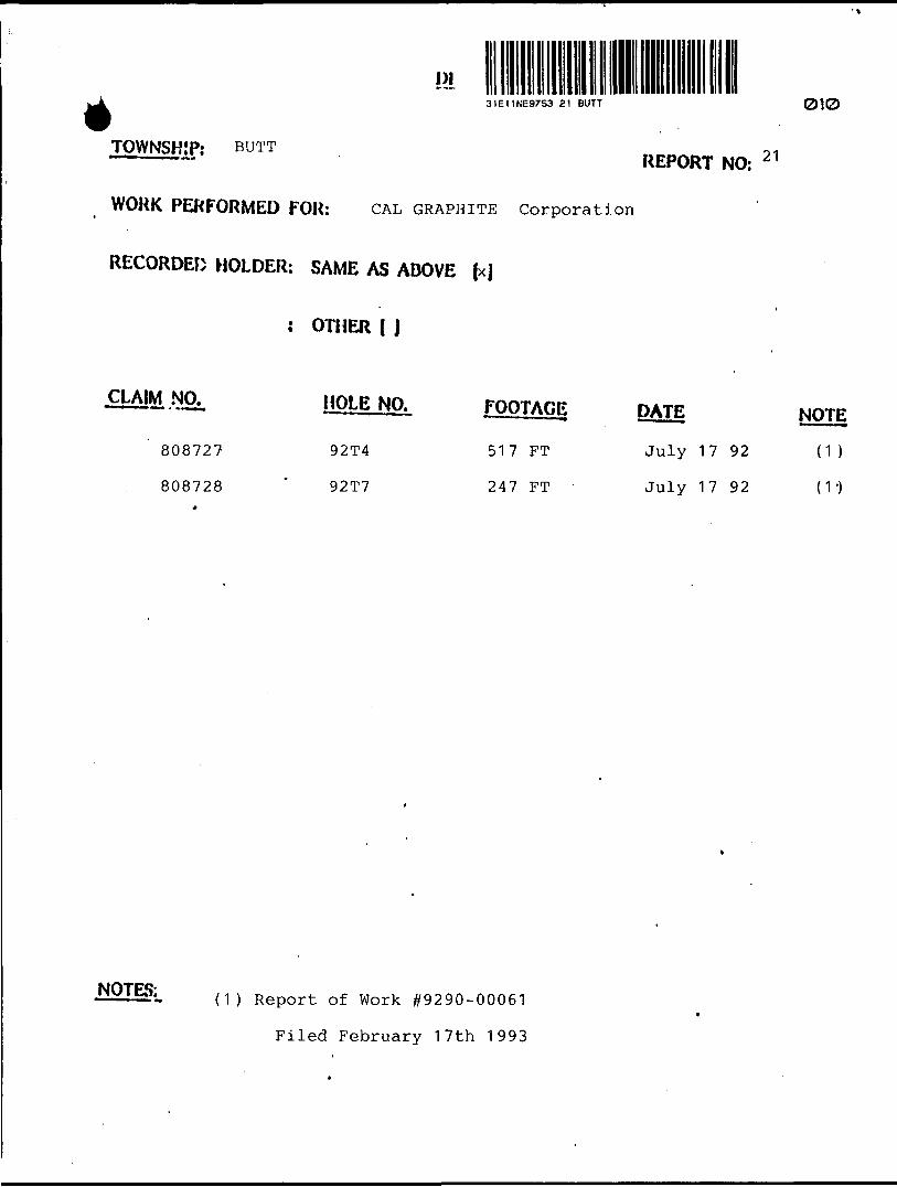
DI
* 31E11NE97S3 21 BUTT 010
TOWNSHIP; BUTTREPORT NO: 2 1
WORK PERFORMED FOR: CAL GRAPHITE corporation
RECORDED HOLDER: SAME AS ABOVE fx|
: OTHER ( J
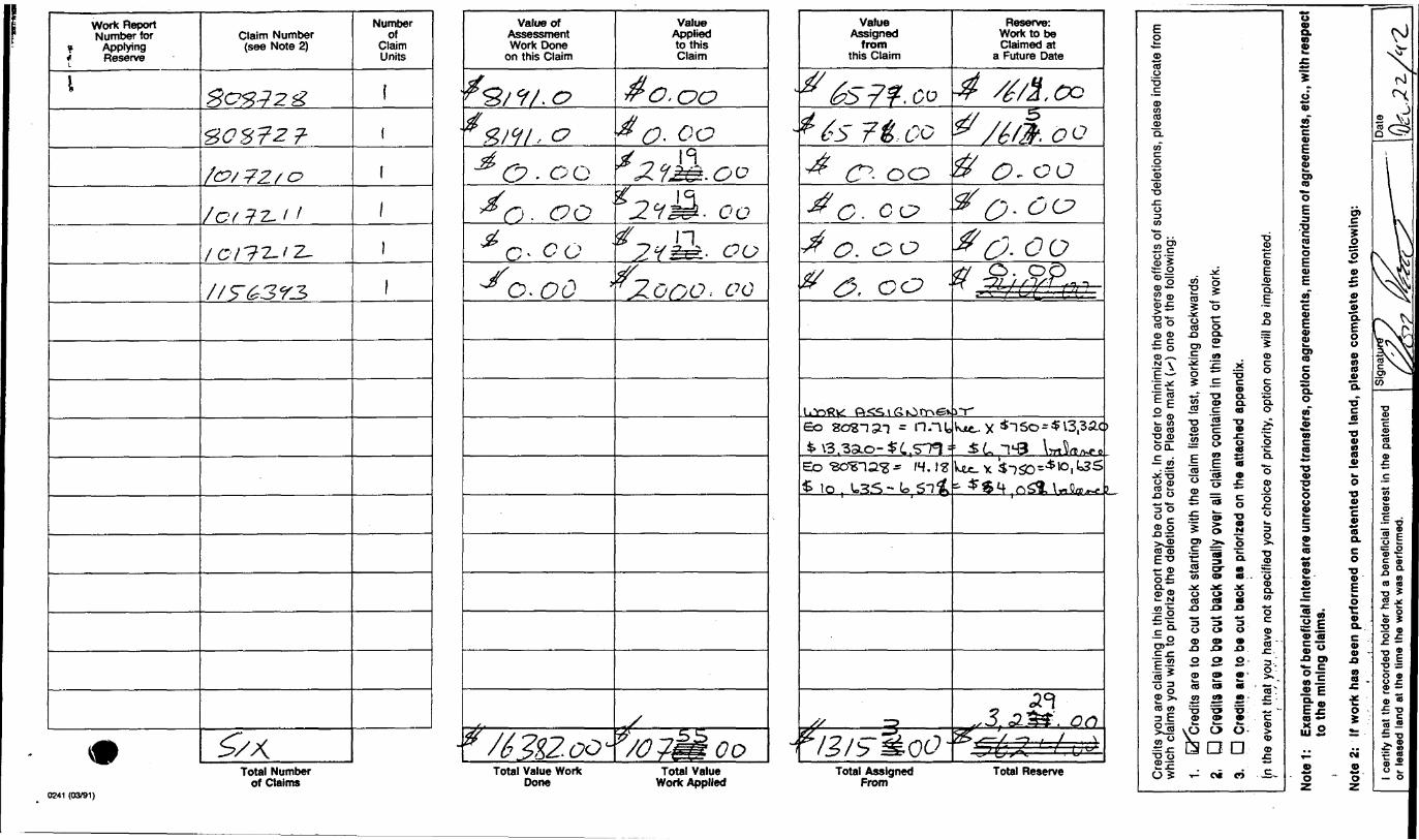
CLAIM NO
808727
808728
HOLE NO.
92T4
92T7
FOOTAGE
517 FT
247 FT
PATE
July 17 92
July 17 92
NOTE
d )
(V)
NOTES: (1) Report of Work #9290-00061
Filed February 17th 1993
MEMORANDUM REPORT
August 17, 1992
TO: Cal Graphite Corporation, Victor Hendricken
FROM: Anthony G. Menard, Consulting Geologist Verona, Ontario
RE: Report on Diamond Drill Holes 92-T-7, 92-T-4
Anthony G. Menard, Consulting Geologist, Verona, Ontario was contracted by
Cal Graphite Corporation to supervise the completion of two diamond drill
holes at the open pit graphite mine. The drill cores were to be examined
noting the pertinent geologic and geotechnical characteristics of the rock.
Particular attention was to be given to assessing the range of graphite flake
sizes.
Samples of the graphite-bearing rock were to be selected for chemical, mineralogic
and mechanical testing at the Canada Centre for Mineral and Energy Technology
(Canmet). The work is now complete and I enclose my report for your consideration.
Two diamond drill holes, designated 92-T-4 and 92-T-7 were completed by Morressette
Drilling Company during the period July 14 to July 21, 1992. The drill cores
were examined by the writer and the results are documented in the appendices to
this report.
Ten core samples for laboratory tests were selected representing the range of
graphite-bearing rock identified in the two drill holes. The basic requirements
for sample selection were: 1. that the specimen be taken from a graphitic
interval not less than the minimum mining width of 20 feet and 2. that the
interval contain a minimum (visually estimated) of X.5% graphitic carbon by
weight.
All samples were labelled with the drill hole number and the down hole direction
of the core specimen. An inventory of the drill core specimens selected for
laboratory analysis is included in the appendices to this report. Samples we.e
packaged and forwarded to Canmet on August 18, 1992.
Distribution of Graphite Flake Sizes:
The distribution of the range of graphite flake sizes in the two drill holes
was estimated by megascopic examination. The method used is as follows:
1) the graphite zone was defined on the basis of lithology
and the visually estimated graphitic carbon content ie: more
than X.5% eg.
2) the zone was then subdivided into 10 foot intervals for
evaluation purposes.
3) the cores were examined with specific reference to identifying
the three principal flake sizes "^48 mesh, "48 mesh - "^100 mesh
and ~100 mesh.
4) the distribution of the flake size group (by volume percentage)
for the 10 foot interval was estimated. This procedure was
repeated for the complete length of the graphite zone.
5) a flake size distribution range for the total core length was
tabulated from the subdivision values.
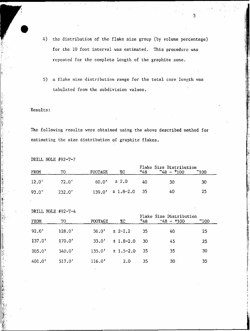
Results:
The following results were obtained using the above described method for
estimating the size distribution of graphite flakes.
DRILL HOLE #92-T-7
Flake Size DistributionFROM
12.0'
93.0'
DRILL HOLE
FROM
92.0'
137.0'
205.0'
401.0'
TO
72.0'
232.0'
#92-T-4
TO
128.0'
170.0'
340.0'
517.0'
FOOTAGE
60.0'
139.0'
FOOTAGE
36.0'
33.0'
135.0'
116.0'
56C
2.0
1.8-2.0
ZC
± 2-2.2
1.8-2.0
1.5-2.0
2.0
+4S
40
35
Flake +4S
35
30
35
35
~48 - +100
30
40
Size Distribution -48 - +100
40
45
35
30
100
30
25
-100
25
25
30
35
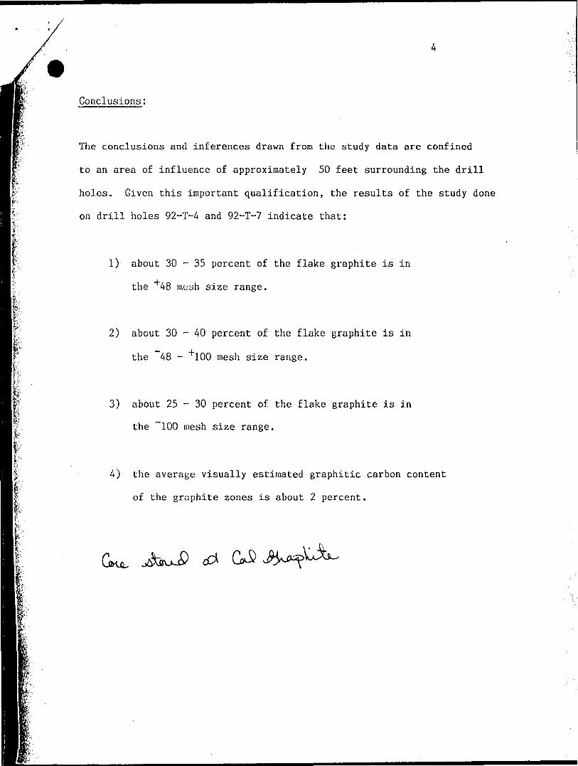
Conclusions:
The conclusions and inferences drawn from the study data are confined
to an area of influence of approximately 50 feet surrounding the drill
holes. Given this important qualification, the results of the study done
on drill holes 92-T-4 and 92-T-7 indicate that:
l
l
Itf
1) about 30 - 35 percent of the flake graphite is in
the 48 mesh size range.
2) about 30 - 40 percent of the flake graphite is in
the 48 - 100 mesh size range.
3) about 25 - 30 percent of the flake graphite is in
the "100 mesh size range.
4) the average visually estimated graphitic carbon content
of the graphite zones is about 2 percent.
t*
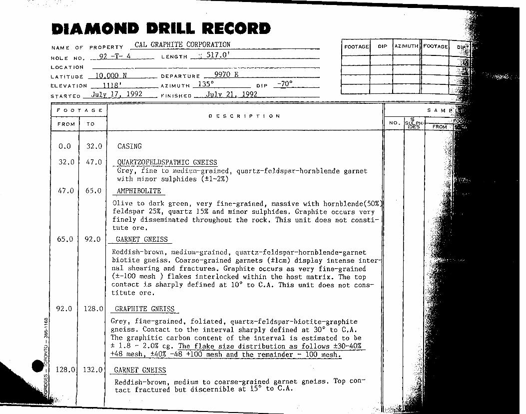
DIAMOND DRILL RECORDNAME OF PROPERTY .
HOLE NO. 92 ~T— 4
LOCATION ,——————————-
LATITUDE 10.000 N
ELEVATION 1118'
CAL GRAPHITE CORPORATIONLENGTH '. 517.0
STARTED July 17. 1992
DEPARTURE —
AZIMUTH 135
FINISHED
9970 EDIP
-70 C
July 21. 1992
FOOTAGE DIP AZIMUTH FOOTAGE
i. a.
""" li. , ^.
O O T A G E
FROM
0.0
32.0
47.0
65.0
92.0
128.0
TO
32.0
47.0
65.0
92.0
128.0
132.0
DESCR1PTI ON
CASING
QUARTZOFELDSPATHIC GNEISSGrey, fine to medium-grained, quartz-feldspar-hornblende garnetwith minor sulphides (il-2%)
AMPHIBOLITE
Olive to dark green, very fine-grained, massive with hornblende(50SD feldspar 25!?, quartz 15% and minor sulphides. Graphite occurs very finely disseminated throughout the rock. This unit does not consti tute ore.
GARNET GNEISS
Reddish-brown, medium-grained, quartz-feldspar-hornblende-garnet biotite gneiss. Coarse-grained garnets ( lcm) display intense inter nal shearing and fractures. Graphite occurs as very fine-grained ( -100 mesh ) flakes interlocked within the host matrix. The top contact is sharply defined at 10 C to C.A. This unit does not cons titute ore.
GRAPHITE GNEISS
Grey, fine-grained, foliated, quartz-feldspar-biotite-graphite gneiss. Contact to the interval sharply defined at 30 0 to C.A. The graphitic carbon content of the interval is estimated to be ± 1 .8 - 2.052 eg. The flake size distribution as follows 30-40% +4S mesh, 40% -48 +100 mesh and the remainder - 100 mesh.
GARNET GNEISS
Reddish-brown, medium to coarse-grained garnet gneiss. Top con tact fractured but discernible at 150 to C.A.
NO.
SAMP"
•m:-'fii\
m
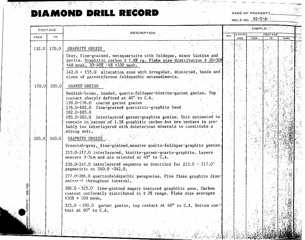
DIAMOND DRILL RECORD NAME OF PROPERTY-
HOLE f92-T-4--
FOOTAGE
FROM TO
DESCRIPTION
SAMPLE; s'
, S ULPH
.IDESFOOTAGE
FROM . TO TOf*L
132.0 170.0
170.0 205.0
205.0 340.0
GRAPHITE GNEISS , . .
Grey, fine-grained, metaquartzite with feldspar, minor biotite and pyrite. Graphitic carbon j.8% eg. Flake size distribution 20-30? +4S mesh, 30-40% -48 +100 mesh.
142.0 - 155.0 alteration zone with irregular, distorted, bands and clots of garnetiferous feldspathic metasediments.
GARNET GNEISS
Reddish-brown, banded, quartz-feldspar-biotite-garnet gneiss. Top contact sharply defined at 40" to C.A. 170.0-176.0 coarse garnet gneiss 176.0-182.0 fine-grained quartzitic-graphite band 182.0-185.0^ -185.0-205.0 interlayered garnet-graphite gneiss. Unit estimated to contain in excess'of 1.555 graphitic carbon-but "ore texture is pro bably, too interlayered with deleterious minerals to constitute a .mining unit.
GRAPHITE'GNEISS v. ' ?
Greenish-grey, fine-grained,massive quartz-feldspar-graphite gneiss,
213.0-217.O interlayered, biotite-garnet-quartz-graphite. Layers measure 2-3cm. and,are oriented at 400 to C.A.
230.0-247.0 interlayered sequence as described for 213.0 - 217.0' pegmatitic at 240.0 -242.0,
277.0-286.0 quartzofeldspathic paragneiss. Fine flake graphite diss- emin.atM throughout interval.
286.0 - 325".O" fine-grained sugary textured graphitic zone, Carbon content uniformily distributed in 2% range. Flake size averages 50% + 100 mesh,
325.0 -330.0 garnet gneiss, top contact at 400 to C.A. Bottom con tact at 600 to C.A.
vi
DIAMOND DRILL RECORD NAME OF PROPER T Y^^^^^^ii-92-T-4 '. ; -. 7-VIP&-."
HOLE NO.
FOOT
FROM .
340.0
401.0
0 D
\ \D75D
1n u 3r
AGE
TO
401.0
517.0
^^^^^^^m
DESCRIPTION
GARNET GNEISSMassive, locally layered, medium to coarse-grained garnet-biotite
gneiss.
GRAPHITE GNEISSGrey, fine-grained, quartz-feldspar-garnet gneiss The graphitic carbon content is visually estimated to be ±1.855 eg. Flake size range includes very fine -100 mesh to +60 mesh. Variations are noted over short (1-2 foot) intervals. . . 460.0'- 465.0' Chlorite and carbonate filled fractures at 5-100 to the C. A. ;; . ' : 480.0 - 483.0 l-2mm fractures' at 5 0 to C. A. '
495.0 -496.0 Lost Core, Mud, gouge material . 507.0 - 511.0 Graphitic carbon .content ±2% eg. ±40/2 coarse flake core recovery 70-8055
517.0 END OF HOLE 92-T-4
SUMMARY:
FROM TO LENGTH 7,C FLAKE SIZE DISTRIBUTION+4S mesh -48+100 -100 mesh
92.0 128.0 36.0' -±2.-070,.-: 35 40 25
137.0 170.0 33'.0' ±1.8-2.035 30 . 45 25 205.0 340.0 135.0' ±1.5-2. 035 35 ' 35 30
401.0 517.0 116.0' ±2.055 35 30 35
Signature:
Date :
' ' ' - - . . ' '" •-•' - i-
NO,; SULPHIDES
:'
SAMPL!
F
FROM
,. . : -';-
•'./w -S
z
OOTAGETO
i '
. . '•-'
.- - \*
. ' " vi
- .-i . V': i
.-. ^
"•".'Y.'-- -*-
: -\* 1-^
^ .; - 1-i'i
gjg^^^^^^j
^fE— 1*sf' v ^—-l-vroTAT^J
fi::]-ffi - - lm.;-.-- 1 3fc^m- -•••~*fff*'Mi- ' -'•'K-.*.-. -*-~*.*. ' • ~-^•:..- : '^:y. , .,y""r"/ \•*i-^v^'•:X----'fi r:Xm: -.-i(..*-'. -•'•rf-' t"' '•S*. ••'.•: t-v,'-.'.•:?t.'"\ -ifr-v.,;,.,:S f'-'i-"-.'1 .s^-••'••v•5* ^fl ,\ ~ .- K--•^**V-'v- ---', ^ :
f^'
m-®iVv? :^SV':-VW*:--' f^v'i&si; -••.iV.~'". ' :'.
V'"--: --l;.'? .
: t'" r
••"'l'*',-' ..•; .-*;1/.. *"; •''•"•*.
''.\f-i-:t'" ~'" .' *-
' ^'*^' '
^^^^
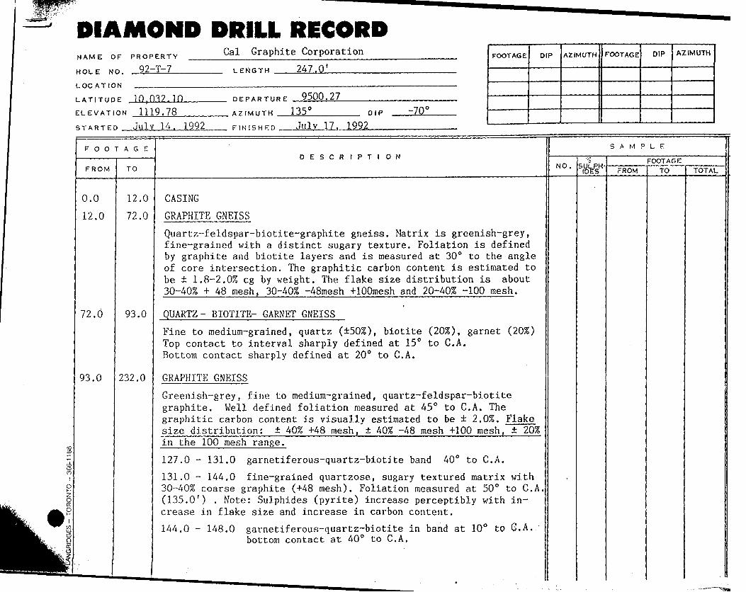
DIAMOND DRILL RECORDNAME OF PROPERTY
HOLE NO. 92-T-7
LOCATION ,—————————
LATITUDE 10,032.10
Cal Graphite Corporation
LENGTH 247.0'
DEPARTURE 9500.27
ELEVATION 1119.78
STARTED July 14. 1992AZIMUTH .
FINISHED
135 CDIP -70!
17. 1992
FOOTAGE DIP AZIMUTH FOOTAGE DIP AZIMUTH
FOOTAGE
FROM TO
DESCRIPTIONSAMPLE
NO. SULPH IDES
FOOTAGEFROM TO
0.0
12.0
12.0
72.0
72.0 93.0
93.0 232.0
CASING
GRAPHITE GNEISS
Quartz-feldspar-biotite-graphite gneiss. Matrix is greenish-grey, fine-grained with a distinct sugary texture. Foliation is defined by graphite and biotite layers and is measured at 30 0 to the angle of core intersection. The graphitic carbon content is estimated to be ± l.S-2.0% eg by weight. The flake size distribution is about 30-40xS * 48 mesh. 30-40^ -48mesh 4-100mesh and 20-40;S -100 mesh.
QUARTZ- BIOTITE- GARNET GNEISS
Fine to medium-grained, quartz (±5055), biotite (20%), garnet (20/0 Top contact to interval sharply defined at 150 to C.A. Bottom contact sharply defined at 200 to C.A.
GRAPHITE GNEISS
Greenish-grey, fine to medium-grained, quartz-feldspar-biotite graphite. Well defined foliation measured at 450 to C.A. The graphitic carbon content is visually estimated to be ± 2 .01. Flake size distribution: ± ^ +A8 mesh, ± ^ -48 mesh +100 mesh, ± 20% in the 100 mesh range.
127.0 - 131.0 garnetiferous-quartz-biotite band 400 to C.A.
131.0 - 144.0 fine-grained quartzose, sugary textured matrix with SO-40% coarse graphite (+4S mesh). Foliation measured at 50 0 to C.A, (135.0') . Note: Sulphides (pyrite) increase perceptibly with in crease in flake size and increase in carbon content.
144.0 - 148.0 garnetiferous-quartz-biotite in band at 10 0 to G.A. bottom contact at 400 to C.A,
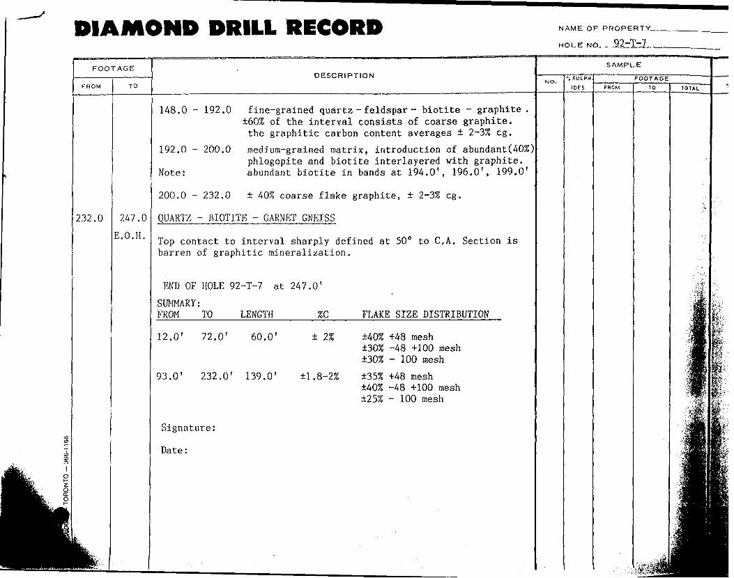
DIAMOND DRILL RECORD NAME OF PROPERTY-
HOLE NO. 92-1-7
FOOTAGE
FROM TO
DESCRIPTION
232.0 247.0
E.O.H.
148.0 - 192.0 fine-grained quartz - feldspar - biotite - graphite . ±60% of the interval consists of coarse graphite, the graphitic carbon content averages ± 2-35S eg.
192.0 - 200.0 medium-grained matrix, introduction of abundant(40%)phlogopite and biotite interlayered with graphite.
Note: abundant biotite in bands at 194.0', 196.0', 199.0'
200.0 - 232.0 ± 407o coarse flake graphite, ± 2-37* eg.
QUARTZ - BIOTITE - GARNET GNEISS
Top contact to interval sharply defined at 50" to C.A. Section is barren of graphitic mineralization.
END OF HOLE 92-T-7 at 247.0'
LENGTH 7oCSUMMARY: FROM TO FLAKE SIZE DISTRIBUTION
12.0' 72.0' 60.0' ± 27.
93.0' 232.0' 139.0' il.8-2%
Signature:
Date:
±405? *48 mesh±30?S -48 +100 mesh±30% - 100 mesh
±35% +4S mesh ±405? -48 +100 mesh ±257, - 100 mesh
f .-.V *i'. 'fe -jt*v " .ii'"-f,*"' 1pjli;f;l''
: ; ;:,;!..
|v
f
|;fi-fi?;;, i Wu. .
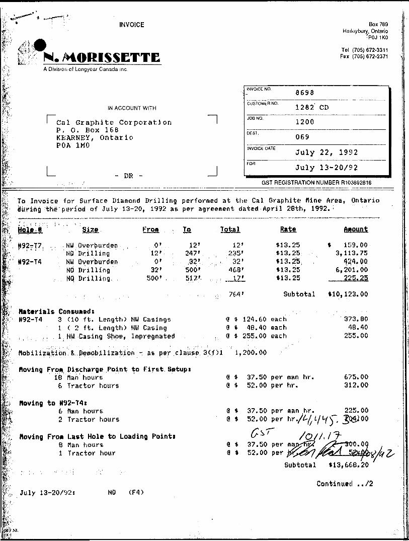
; INVOICE
, 0II N. MORISSETTE
A Division of Longyoar Canada Inc.
"-
IN ACCOUNT WITH
' Cal Graphite Corporation lP, 0. Box 168KEARNEY, OntarioPOA 1MO
1 1 1 — - DR - — 1
—————————————————— .. ———————————————————————————————————————————————————————————————— . ———
To Invoice for Surface Diamond Drilling performed at th
Box 789 IHailoybury. Ontario J[
•POJ 1KO j
Tol (705)672-3311 iFax (705)672-2371 |
1INVOICE NO. , , , 16698CUSTOMER NO. 1 282 ' CD
1200
DEST. . . 069
INVOICE DATE . , -. ^ , . ~ rtJuly 22, 1992
Fon July 13-20/92GST REGISTRATION NUMBER R103892816
K Cal Graphite Mine Area, OntarioC| during the period of July 13-20, 1992 at per agreement dated April 28th, 1992. ;
fc'ia ;. - .j^jft:'.' /'p.';
jfr,M 1 'ip
Hple-il Size Fro* To . lot^l
H92rrT7, .. . NW Overburden , . 0' 12' 12'' "' " 'NO Drilling 12' 247' ,, .?35'H92-T4 NW Overburden 0' .32'.. - 32'
NO Drilling 32' 500' 468'
Rate ftitount i
H13.25 * 159.00 '*13, 25 3,113.75 'tl3.25, , " 424. OQ*13.25 6,201.00 I
fe . NQ Drillino. 500', 517'. .. . : 17' *13.25 225.25fflPw "'
w :P' HaterialB ConBuaedt
Subtotal *10,123.00 j
1|f H92-T4 3 (10 ft. Length) NW Casings Q * 121.60 each 373.80|J; 1 C 2 ft. Length) NW Casing S * 48.40 each 48.40|j. , ; ,. . l, NW Casing Shoe, Impregnated , 9 :* 255,00 each 255.00 l
P
1,fe:f-A * '
feiW'4
l!.tp*pt;P"
liItl:f®*'
Mobilization fc. peiaobilization - as per clause 3(f)l 1,200.00
Moving Fro* Discharge Point; to First Setup i18 Man hours 9 *
S Tractor hours 9 S
Moving to H92-T4I6 Man hours Q *2 Tractor hours @ i
Moving Fro* Last Hole to Loading Pointi8 Man hours 0 *1 Tractor hour 9 *
July 13-20/^2! NO (F4)
.
37.50 per man hr. 675.0052.00 per hr. 312.00
37.50 per man hr. 225.0052.00 per ^ •/^•L^l ( '\ t 1&4JOO
0-^T /Q//.IJ-37.50 per mapjrfijX / "j '3^*'^952. 00 per fe^*^^7 0jZifts'\ SStf-jOftc^yjv 7^
Subtotal *13,668.20
Continued ../2
. : l
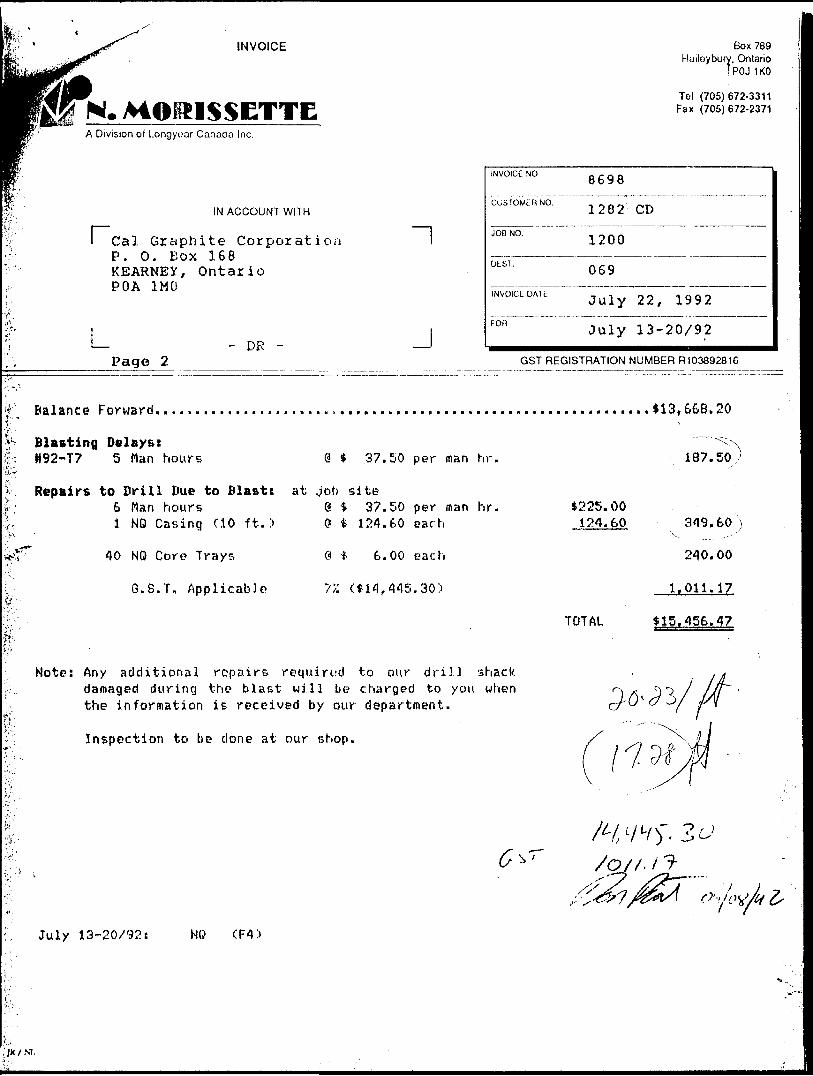
INVOICE
N. MOimSETTEA Division ot Longyuar Canada Inc.
rIN ACCOUNT WITH
Cal Grciphite Corporation P. O. Box 168 KEARNEY, Ontario POA 1MO
L - DR -Page 2
~l
J
Box 789Hailoyburv, Ontario
*POJ 1KO
Tol (705)672-3311 Fax (705)672-2371
INVOICE NO.
CUSTOMER NO.
JOB NO.
DEST.
INVOICE DATE
fon
8698
1282 CD
1200
069
July 22, 1992
July 13-20/92
GST REGISTRATION NUMBER R103892616
Balance Forward................,..... ,.......,...............................*13,668.20
Blasting Delays:H92-T7 5 Man hours @ 37.50 per man hr.
Repairs to Drill Due to Blast: at job site6 Man hours @ * 37.50 per man hr.l NO Casing (10 ft.) O t 124.60 each
40 NO Core? Trays
G.8.T. Applicable
Q * 6.00 each
77. ( fi1 f 445.30:i
*225.00 124.60
TOTAL
187.50,
349.60
240.00
1.011.17
S15.456.47
Note: Any additional repairs required to our drill shack damaged during the blast will be charged to you when the information is received by our department.
Inspection to be clone at our shop.
July 13-20/92: NO (R l
H w
; JK i M .
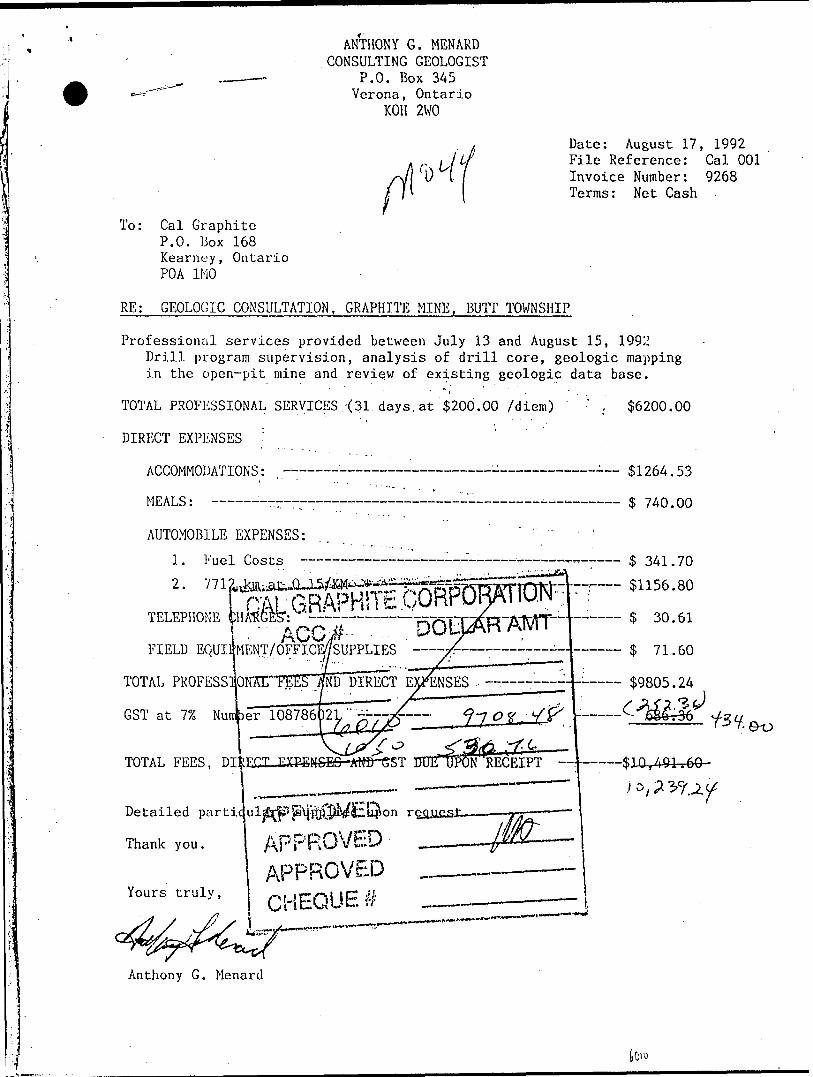
ANTHONY G. MENARD CONSULTING GEOLOGIST
P.O. Box 345 Verona, Ontario
KOH 2WO
Date: August 17, 1992 File Reference: Cal 001 Invoice Number: 9268 Terms: Net Cash
To: Cal Graphite P.O. Box 168 Kearncy, Ontario POA 1MO
RE: GEOLOGIC CONSULTATION, GRAPHITE MINE, BUTT TOWNSHIP
Professional services provided between July 13 and August 15, 1992 Drill program supervision, analysis of drill core, geologic mapping in the open-pit mine and review of existing geologic data base.
TOTAL PROFESSIONAL SERVICES .-(31 days, at 200.00 /diem) '
DIRECT EXPENSES :
ACCOMMODATIONS: ——————————————————-——————
MEALS: ————~rr~————————-——-—-————-——
AUTOMOBILE EXPENSES:
1. Fuel Costs
2.
$6200.00
$1264.53
$ 740.00
341.70
TELEPHONE A r* f*.FIELD EQUiifMENT/OFFicE/feuppLiES
TOTAL PROFESSIONTHTTEET*/
GST at 17, Nunfcer 108786^
ND DIRECT E^ENSES . -————^4--——— $9805.24
2JL-i^ Y——-
TOTAL FEES, Dl|ECX-EXBfiMSES-^tW~GST TrDE^PONRECEIPT
Detailed pa
Thank you.
Yours truly,
APPROVED
APPROVED CHEQUE #
Anthony G. Menard
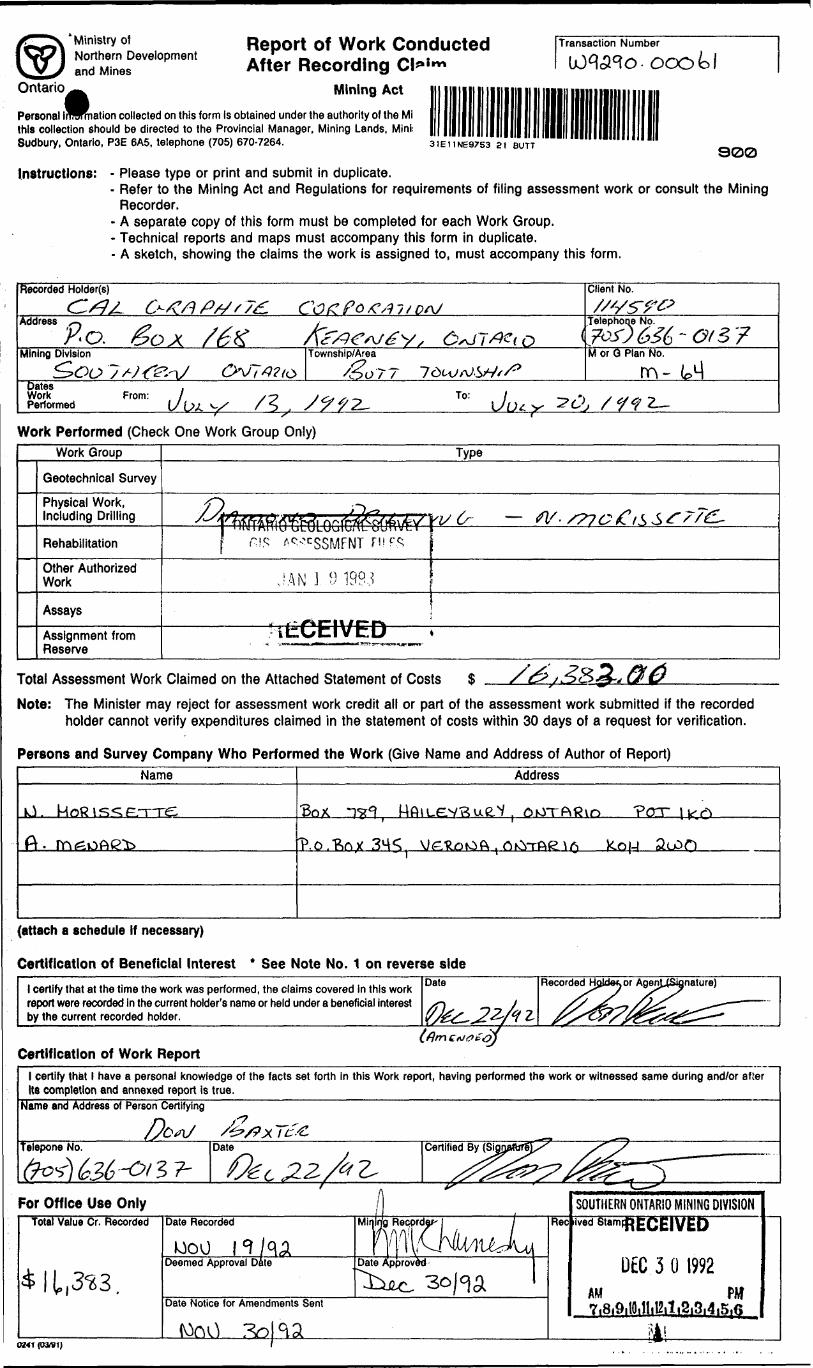
'Ministry of Northern Development and Mines
Report of Work Conducted After Recording
Mining Act
Transaction Number
nation collected on this form Is obtained under the authority of the Mi this collection should be directed to the Provincial Manager, Mining Lands, Mini: Sudbury, Ontario, P3E 6A5, telephone (705) 670-7264. 3IEI1NE97S3 21 BUTT
900
Instructions: - Please type or print and submit in duplicate.- Refer to the Mining Act and Regulations for requirements of filing assessment work or consult the Mining
Recorder.- A separate copy of this form must be completed for each Work Group.- Technical reports and maps must accompany this form in duplicate.- A sketch, showing the claims the work is assigned to, must accompany this form.
Recorded Holder(s) Client No.
Address ,-, .,
P-o. go x /6XTelephone No.
oMining Division Township/Area M or Q Plan No.
rnDates Work Performed
From:.l
\J/-y / 5
To:Work Performed (Check One Work Group Only)
Work Group
Geotechnical Survey
Physical Work,Including Drilling
Rehabilitation
Other Authorized Work
Assays
Assignment fromReserve
^Arfkt&WA 1&5? JV?)/ r-yi
f
JAN J. 9 199.3
* t f* f* F i \/ F ri
Type
Ki/ d/- W - S77C fCl^^f//^-
i
Total Assessment Work Claimed on the Attached Statement of Costs $
Note: The Minister may reject for assessment work credit all or part of the assessment work submitted if the recorded holder cannot verify expenditures claimed in the statement of costs within 30 days of a request for verification.
Persons and Survey Company Who Performed the Work (Give Name and Address of Author of Report)Name Address
M oft i s 5;
A.
(attach a schedule If necessary)
Certification of Beneficial Interest * See Note No. 1 on reverse side1 certify that at the time the work was performed, the claims covered In this work report were recorded in the current holder's name or held under a beneficial interest by the current recorded holder.
Date Recorded
Certification of Work Report1 certify that 1 have a personal knowledge of the facts set forth in this Work report, having performed the work or witnessed same during and/or afier Its completion and annexed report Is true.
Name and Address of Person Certifying
Telepone No. Date'c Z,
Certified By (Si
For Office Use OnlyTotal Value Cr. Recorded
* 11,3^3.
0241 (33fei)
Date Recorded
tooo f^/q^Deemed Approval Date
Date Notice for Amendments Sent
(Ooo /^Kai
iMir Ing Recprda^- j j
Date Approved- J
ReeSOUTHERN ONTARIO MINING DIVISIONiV6dStamPRECEIVED
DEC. 3 01992 AM m7i8i9itOilli12it i2,3,4i5,(?
fl !
f s* if al5?^ U ~
O xA
j M 1- —
0 SO ^ —
Ni ^ —
! M —
*- ^ \VA
J ^ —
3^
| 2
lljl
-Q W
Q}
If
cQ
?
2.w.
a|
^
1 •vi
l ife Q)
O
V \
o o y^ o o Oj C
O f o C' M 1- Q c
^ Q O kT •^c a o o
0 t 0 O """x
^l
t 0 Q
x ^ \
~^^*
V1 0 o
x b c^
Iff*
w", 3
2 5
* 3*
* S
Iff?
li \ \. m o f~*\ V r
([
^™* J^ |. V. ^
^. l) \ Us ib
Ci ^
-5®
r S
5-
*'CA
X
O
^
" f
flft
X K" r 5
o
—
i fl"
~
1 (A
IJ
*r
g1
.^
Mo!
Q
p)
oQ
0
^J
r^
d
\\ *~
Vt ^
r ^
t [K
1*
tjjl
fh
-^—
tl
i M
*s? *
—S
j-O
? — G.
——
——
——
——
——
——
——
——
——
——
——
— —
—
—
——
—
\ p T 3 P6 ——
—
H
ra^
V/i o 0 ^
,^j
l jl
oQ :o j
V Q} 0 c ^ \^3 Q)
Q
\ O o ^r^ X.J Q
^ c\ 0 0 ^X
"
V J G C
-^.
JX ^~\ "M
O ^ x^ C^v C
^ w o G ^^
rJS
^
^
- "* ?
w ^
1 i
DI 7Q
^3J
III!
sa
p0
1U i Cr
edits
you
are
cla
imin
g in
this
repo
rt m
ay b
e cu
t bac
k. In
ord
er to
min
imize
the
adve
rse
effe
cts
of s
uch
dele
tions
, ple
ase
indi
cate
from
wh
ich c
laim
s yo
u wi
sh to
prio
rize
the
dele
tion
of c
redi
ts.
Plea
se m
ark
(^)
one
of th
e fo
llowi
ng:
1. Q
wre
dits
are
to b
e cu
t bac
k sta
rting
with
the
claim
liste
d las
t, wo
rking
bac
kwar
ds.
2. D
Cred
its a
re to
be c
ut ba
ck e
quall
y ove
r all c
laims
conta
ined
in thi
s rep
ort o
f work
.3.
D C
redit
s ar
e to
be c
ut b
ack
aa p
rlorlz
ed o
n th
e at
tach
ed a
ppen
dix.
In th
e ev
ent t
hat y
ou h
ave
not s
pecif
ied
your
cho
ice
of p
riorit
y, o
ptio
n on
e wi
ll be
impl
emen
ted.
Note
1:
Exam
ples
of b
enef
icial
Inte
rest
are u
nrec
orde
d tra
nsfe
rs, o
ptio
n ag
reem
ents
, mem
oran
'dum
of ag
reem
ents
, etc
., wi
th re
spec
tto
the
min
ing
claim
s.j
Note
2;
If w
ork
has
been
per
form
ed o
n pa
tent
ed o
r le
ased
land
, ple
ase
com
plet
e th
e fo
llow
ing:
l cer
tify
that
the
rec
orde
d ho
lder
had
a b
enef
icia
l int
eres
t in
the
pate
nted
or
leas
ed la
nd a
t the
tim
e th
e wo
rk w
as p
erfo
rmed
.
Ontario
Ministry olNorthern Developmentand Mines
^Ministere duleVeloppement du Nord it des mines
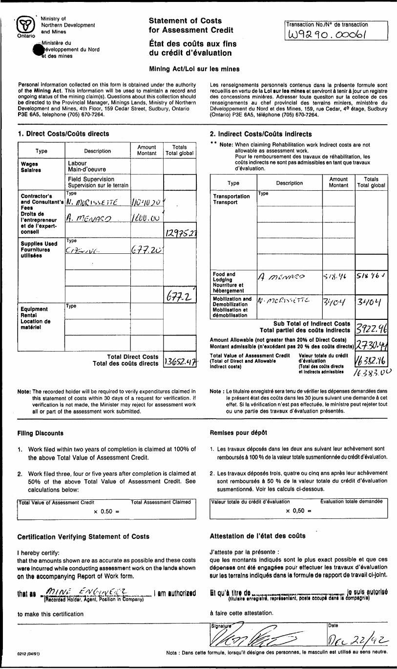
Statement of Costs for Assessment CreditBat des couts aux fins du credit devaluation
Mining Act/Loi sur les mines
Transaction No./N 0 de transaction
Personal information collected on this form is obtained under the authority of the Mining Act. This information will be used to maintain a record and ongoing status of the mining claim(s). Questions about this collection should be directed to the Provincial Manager, Minings Lands, Ministry of Northern Development and Mines, 4th Floor, 159 Cedar Street, Sudbury, Ontario P3E 6A5, telephone (705) 670-7264.
Les renseignements personnels contenus dans la presente formule sont recueillis en vertu de la Lo) sur les mines et servlront a tenlr a jour un reglstre des concessions minieres. Adresser toute quesiton sur la collece de ces renseignements au chef provincial des terrains miniers, ministere du Developpement du Nord et des Mines, 159, rue Cedar, 4e Stage, Sudbury (Ontario) P3E 6A5, telephone (705) 670-7264.
1. Direct Costs/CoQts directs
Type
Wages Salaires
Contractor's and Consultant's Fees Drolts de ('entrepreneur et de I'expert- consell
Supplies Used Fournltures utillsees
Equipment Rental Location de materiel
Description
Labour Main-d'oeuvreField Supervision Supervision sur le terrain
Type rV. /fluCl^fiTt
d. M&VfXO
Type
Oi^./1/V-
Type
Amount Montant
IJC'IOJO
/^/JO.Oo'
617.20
Total Direct Costs Total des couts directs
Totals Total global
t
ai?Z3i
6m
\36S24?
2. Indirect Costs/CoOts Indirects* * Note: When claiming Rehabilitation work Indirect costs are not
allowable as assessment work.Pour le remboursement des travaux de rehabilitation, les couts indirects ne sont pas admissibles en tent que travaux devaluation.
Type
Transportation Transport
Food and Lodging Nourrlture et hebergementMobilization and Demobilization Mobilisation et demobilisation
Description
Type
/? X^c/V/X1^
/V-S?7Cf?l^''tTT6-
Amount Montan!
s-/* 1/*
?l /c 'H
Sub Total of Indirect Costs Total partlel des couts Indirects
Amount Allowable (not greater than 20~tt of Direct Costs) Montan! admissible (n'exc6dant pas 20 H des coQts directs)Total Value of Assessment Credit Valeur totale du credit (Total of Direct and Allowable devaluationIndirect costal (Total de* coflt* direct!
Totals Total global
SI* it) J
3W y
^22,^
2130Wtte&.ti*
•t Indirect* admissible* /^ ^ y 2, (}O
Note: The recorded holder will be required to verify expenditures claimed in this statement of costs within 30 days of a request for verification. If verification is not made, the Minister may reject for assessment work all or part of the assessment work submitted.
Note : Le titulaire enregistre sera tenu de verifier les defenses demandees dans le present etat des couts dans les 30 jours suivant une demande a cet effet. Si la verification n'est pas effectuee, le ministre peut rejeter tout ou une partie des travaux devaluation pr6sent6s.
Filing Discounts
1. Work filed within two years of completion is claimed at 10007o of the above Total Value of Assessment Credit.
2. Work filed three, four or five years after completion is claimed at BQO/Q of the above Total Value of Assessment Credit. See calculations below:
Total Value of Assessment Credit Total Assessment Claimed
x 0.50 =
Remises pour depdt
1. Les travaux de*pose's dans les deux ans suivant leur achevement sont rembours6s a 100 W de la valour totale susmentionnee du credit devaluation.
2. Les travaux deposes trois, quatre ou cinq ans apres leur achevement sont rembourses a 50 "/o de la valeur totale du credit devaluation susmentionne. Voir les calculs ci-dessous.
Valeur totale du credit devaluation
x 0,50
Evaluation totale demanded
Certification Verifying Statement of Costs
l hereby certify:that the amounts shown are as accurate as possible and these costs were incurred while conducting assessment work on the lands shown on the accompanying Report of Work form.
that aa SftifVf- f /V O-/, y t, -CI-HUM W IB-MfirOTHlfctftnrtml tv -.i-aT lTi*-i l Y-iV*--V -^Hr"-^-|" f-~ - - --' ' ~- -— '--
(Ricordeo HoldBf, Agent, Position In Company)
to make this certification
em authorllfid"l' 1 KUUIWllftVW
Attestation de 1'etat des coQts
J'atteste par la presente :que les montants indiques sont le plus exact possible et que ces depenses ont ete engagees pour effectuer les travaux devaluation stir les terrains indiques dans la formule de rapport de travail ci-joint.
Et qu'l litre de _ H—(tituleif* •nfegliul, rcpr
a faire cette attestation.
, — , —— rr~r .ni, posts oeeup* dam la eompaflnle)
0212 /04/91J Nota : Dans cette formule, lorsqu'll designs des personnes, le masculin est utilise au sens neutre.
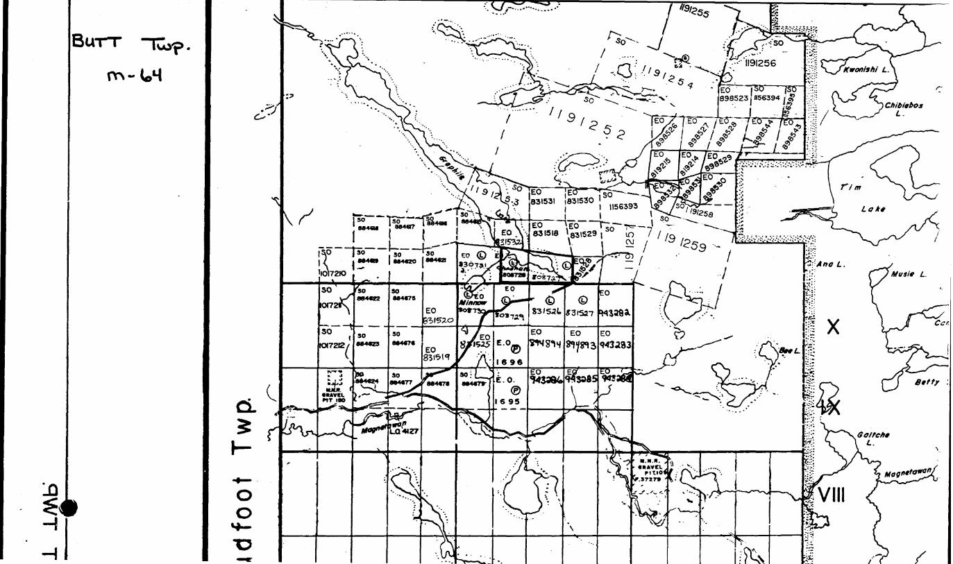
[BUTT luyp
iiH
Ed |BC 898523 1156394 . #
, f 1*5
/
Ontario
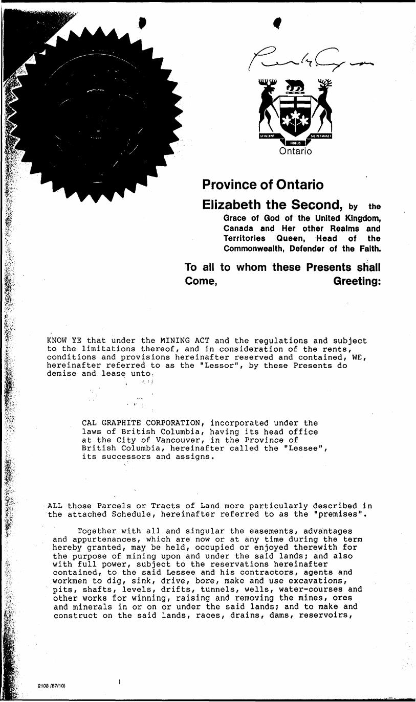
Province of Ontario Elizabeth the Second, by the
Grace of God of the United Kingdom, Canada and Her other Realms and Territories Queen, Head of the Commonwealth, Defender of the Faith.
To all to whom these Presents shall Come, Greeting:
KNOW YE that under the MINING ACT and the regulations and subject to the limitations thereof, and in consideration of the rents, conditions and provisions hereinafter reserved and contained, WE, hereinafter referred to as the "Lessor", by these Presents do demise and lease unto..
W- CAL GRAPHITE CORPORATION, incorporated under the laws of British Columbia, having its head office at the City of Vancouver, in the Province of British Columbia, hereinafter called the "Lessee", its successors and assigns.
'fe
M"
V)';^. '
*:i'3', :
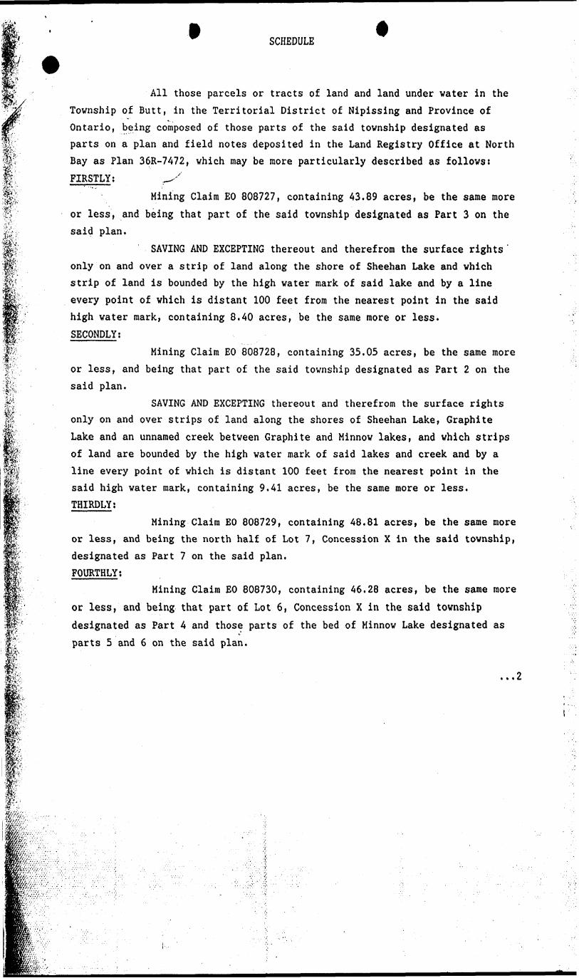
ALL those Parcels or Tracts of Land more particularly described in the attached Schedule, hereinafter referred to as the "premises".
Together with all and singular the easements, advantages and appurtenances, which are now or at any time during the term hereby granted, may be held, occupied or enjoyed therewith for the purpose of mining upon and under the said lands; and also with full power, subject to the reservations hereinafter contained, to the said Lessee and his contractors, agents and workmen to dig, sink, drive, bore, make and use excavations, pits, shafts, levels, drifts, tunnels, wells, water-courses and other works for winning, raising and removing the mines, ores and minerals in or on or under the said lands? and to make and construct on the said lands, races, drains, dams, reservoirs,
2108/87/10)
SCHEDULE
st-ifP1:'-
m
All those parcels or tracts of land and land under water in the Township of Butt, in the Territorial District of Nipissing and Province of Ontario, being composed of those parts of the said township designated as parts on a plan and field notes deposited in the Land Registry Office at North Bay as Plan 36R-7472, which may be more particularly described as follows: FIRSTLY; ^
Mining Claim EO 808727, containing 43.89 acres, be the same more or less, and being that part of the said township designated as Part 3 on the said plan.
SAVING AND EXCEPTING thereout and therefrom the surface rights ' only on and over a strip of land along the shore of Sheehan Lake and which strip of land is bounded by the high water mark of said lake and by a line every point of which is distant 100 feet from the nearest point in the said high water mark, containing 8.40 acres, be the same more or less. SECONDLY;
Mining Claim EO 808728, containing 35.05 acres, be the same more or less, and being that part of the said township designated as Part 2 on the said plan.
SAVING AND EXCEPTING thereout and therefrom the surface rights only on and over strips of land along the shores of Sheehan Lake, Graphite Lake and an unnamed creek between Graphite and Minnow lakes, and which strips of land are bounded by the high water mark of said lakes and creek and by a line every point of which is distant 100 feet from the nearest point in the said high water mark, containing 9.41 acres, be the same more or less. THIRDLY;
Mining Claim EO 808729, containing 48.81 acres, be the same more or less, and being the north half of Lot 7, Concession X in the said township, designated as Part 7 on the said plan. FOURTHLY;
Mining Claim EO 808730, containing 46.28 acres, be the same more or less, and being that part of Lot 6, Concession X in the said township designated as Part 4 and those parts of the bed of Minnow Lake designated as parts 5 and 6 on the said plan.
...2
m
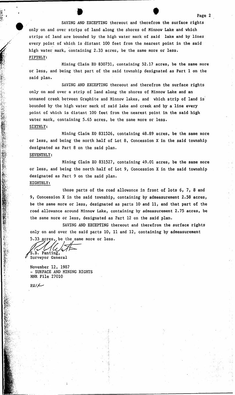
Page 2SAVING AND EXCEPTING thereout and therefrom the surface rights
only on and over strips of land along the shores of Minnow Lake and which strips of land are bounded by the high water mark of said lake and by lines every point of which is distant 100 feet from the nearest point in the said high water mark, containing 2.33 acres, be the same more or less. FIFTHLY;
Mining Claim EO 830731, containing 52.17 acres, be the same more or less, and being that part of the said township designated as Part l on the said plan.
SAVING AND EXCEPTING thereout and therefrom the surface rights only on and over a strip of land along the shores of Minnow Lake and an
unnamed creek between Graphite and Minnow lakes, and which strip of land is bounded by the high water mark of said lake and creek and by a line every point of which is distant 100 feet from the nearest point in the said high water mark, containing 5.65 acres, be the same more or less. SIXTHLY;
Mining Claim EO 831526, containing 48.89 acres, be the same more or less, and being the north half of Lot 8, Concession X in the said township designated as Part 8 on the said plan.
SEVENTHLY;
Mining Claim EO 831527, containing 49.01 acres, be the same more or less, and being the north half of Lot 9, Concession X in the said township designated as Part 9 on the said plan. EIGHTHLY;
those parts of the road allowance in front of lots 6 f 7, 8 and 9, Concession X in the said township, containing by admeasurement 2.58 acres, be the same more or less, designated as parts 10 and 11, and that part of the road allowance around Minnow Lake, containing by admeasurement 2.75 acres, be the same more or less, designated as Part 12 on the said plan.
SAVING AND EXCEPTING thereout and therefrom the surface rights only on and over the said parts 10, 11 and 12, containing by admeasurement 5.33 acres, be the same more or less.
Panting, Surveyor General
November 12, 1987- SURFACE AND MINING RIGHTSMNR File 27010
RW/A-
mp-f-jj.-..'aff.-f'-
-3e7!^^
l CAL GRAPHITE CORPORATIONKeamey. Ontario
s 200'approxGRAPHITE LAKE
; - l x t-y-P^-iSi L t-j: - ra *
.Q. .8.0 8.7 2.8. PART 2
f,- tuf.c. r wuE 3*?; l-JADT l/^* , 6- -^j s :-se. A: - 1.2C . is - . j; ae r PART lU
^^J
*"'- 'i ?S*p*tJ*^*t*""-'-;*r-:;;. - --^—r-
1. Graphit.
O
8o"
1 200'
E'ev. 1000'
*."-'•VJ'^7r.C'' ^ l
SCALE --r x *- '50______ 100 150 **-
O oQ
CAL GRAPHITE CORPORATION________K>^^ngy. Ontorio _____
BUTT TOWNSHIP PROJECTButt Township. Ontorio '
SECTION .9500^ EAST
feetAM
a 50'FT.
*
s ir 8
•fr 55 oo (S) ^ fi! t!
C/) rn
C") -H
O u0
O 'o
o
(U (1
- l
U!
- -t
't 0
-i
"" '
0
"X
* .Vi i- ;:i;
li '(J
c^ :)* r- 0 :M.•? >
q -w
4K
-•.-
Hf)
rno
i ,r o
n' "U
"i. :o
ij C'
)
o'O :o "C
I
- . i
f^'/J
:*jCI
.^i
-.ji
'V.)


![CHAPTER 13 WET DIGESTION METHODS - Strona Głó · PDF fileCHAPTER 13 WET DIGESTION METHODS ... material pertinent to either organic [15-18] or ... Glassy carbon graphite](https://img.pdfslide.net/doc/110x75/5a9e111e7f8b9a29228d2334/chapter-13-wet-digestion-methods-strona-gl-chapter-13-wet-digestion-methods.jpg)