Embed Size (px)
Citation preview
REPUBLIC OF YEMEN
MINISTRY OF AGRICULTURE AND IRRIGATION
IRRIGATION IMPROVEMENT PROJECT (IDA Credit No. 3412 – YEM)
Main Technical Assistance Package for IIP
WORKING PAPER 17
Mission Report Information Analyst
IN ASSOCIATION WITH
July 2003
IIP/ WP 17 / JULY 2003 i
CONTENTS
1 WORK PLAN TO END OF PROJECT MIS-GIS_________________ 1
1.1 Introduction ________________________________________________ 1
1.2 Work Plan June 15th to July 4th, 2003 ____________________________ 1
1.3 Work Plan August/September, 2003 _____________________________ 2
1.3.1 MIS-GIS ______________________________________________ 2
1.3.2 SMM_________________________________________________ 2
2 IIP-MIS SITUATION, CURRENT STATUS AS PER JUNE 03______ 3
2.1 Introduction ________________________________________________ 3
2.2 Comments on MIS - Current Situation and Planning ________________ 4
2.2.1 Item 1 Basic Information _________________________________ 4
2.2.2 Item 2 Generating Information Needs _______________________ 6
2.2.3 Item 3 FOCUS of Reports ________________________________ 7
2.2.4 Item 4 Identification of Users of Reports and Information _______ 8
2.2.5 Item 5 WUA Performance ________________________________ 9
3 NOTES ON WP 5A - FWS SPECIFICATIONS_________________ 10
4 MISCELANEOUS ISSUES ________________________________ 11
4.1 manuals __________________________________________________ 11
4.2 Command Areas____________________________________________ 11
LIST OF APPENDICES
Appendix A: Preliminary draft manual for ARCVIEW Operations
Appendix B: Work Plan for Abdul Rahman
Appendix C: Work Plan for Mohammed Hodish
Appendix D: Performance assessment of water users associations and data requirements for management information system
Appendix E: Data description PIM Performance
IIP/ WP 17 / JULY 2003 ii
ABBREVIATIONS AND ACRONYMS
FWS Flood Warning System GIS Geographical Information System IIP Irrigation Improvement Project M&E Monitoring and Evaluation MAI Ministry of Agriculture & Irrigation MIS Management Information System NWRA National Water Resources Authority O&M Operation and Maintenance Ogma (Traditional) earthen diversion weir PIM Participatory Irrigation Management PIP Project Implementation Plan PIU Project Implementation Unit PMU Project Management Unit RAO Regional Agricultural Office of MAI RDA Regional Development Authority of MAI RIA Regional Irrigation Agency RID Regional Irrigation Department RoY Republic of Yemen RTU Remote Telecommunications Unit SIIP Spate Irrigation Improvement Project (original name for IIP) SMM Spate Management Model SMU Scheme Management Unit SRADP Southern Rural Agricultural Development Project SSHARDA Sana'a/Sadah/Hajja Development Authority TDA Tihama Development Authority of MAI ToR Terms of Reference TREC T.R.E. Chidley WBI World Bank Institute WIS Water Institutions Specialist WM Water Master WP Working Paper WUA Water User Association WUG Water User Group
IIP/ WP 17 / JULY 2003 iii
WORKING PAPERS
WP 1 – Water Management in Wadi Tuban & Wadi Zabid Alan Clark
WP 2 – Concept Paper Management Information Systems Thomas R. E. Chidley
WP 3 – Training Report No.1 – Orientation Workshops Olaf Verheijen
WP-4 – Procedure Manual on Participatory Irrigation Management Olaf Verheijen
WP 5 – Concept Paper for Flood Warning System John Windebank
WP 6 – Hydrological Analysis David T. Plinston
WP 7 – Community Awareness Campaigns Darryl Kuhnle
WP 8 – Gates Assessment – Interim Report David A. R. Wood
WP 9 – Initial Roads Study Abbas A. Abu Taleb
WP 10 – Training Report 2 Olaf Verheijen
WP 11 – Training Report 3 Olaf Verheijen
WP 12 – Issue Paper on PIM
Wicher Boissevain/Olaf Verheijen WP 13 – Irrigation Management (First Mission Report)
Wicher Boissevain WP 14 – Hydrological Analysis-Interim Report 2
David Plinston/Abdul-Aziz Abdullah Ahmed Al-Ariki WP 15 – Progress Report MIS-GIS
Reint-Jan de Blois/Mohammed Ahmed Abdulrahim Hodish/Abdulrahman Mujahed WP 16 – Training Report 4
Olaf Verheijen
Irrigation Improvement Project Mission Report Information Analyst
IIP/ WP 17 / JULY 2003 1
1 WORK PLAN TO END OF PROJECT MIS-GIS
1.1 INTRODUCTION This work plan represents activities planned for the period June 15th to 4th July. It also outlines activities proposed for a final input to be made in August or September 2003 to assist with integration of the MIS with the SMM and updating the MIS/GIS in the light of additional inputs by the Hydrologist etc.
It also takes into account other inputs, including those by Reint-Jan de Blois present in May-June (WP 15). During this period a Progress Report on the MIS-GIS was prepared. The Progress Report looked at the following topics:
1. MIS Development 2. PIM Component 3. Gates Component 4. Hydrology Component 5. GIS Developments 6. WORKPLAN 3rd Quarter 2002
1.2 WORK PLAN JUNE 15TH TO JULY 4TH, 2003 1. Review Progress Report MIS-GIS, to June 2003
2. Continue development of MIS. a. Test procedures for maintaining multiple copies of the MIS at the different
locations (Database Replication and Synchronization) b. Further refinement and development of the database designs (Gates, PIM,
Hydrology, Equipment) c. Testing of components (Gates, PIM, Hydrology, Equipment). d. Identify work items for local MIS specialist e. Continue development of systems for incorporating dual language interface to
MIS f. Linking MIS with GIS (Irrigation assets, PIM)
3. Assist with preparation of Satellite Image maps. a. Checking Geo-referencing of W. Tuban images (Panchromatic and Multi-
spectral) b. Finalization of Pan-Sharpening of images
4. Introduction of procedures for adding attributes to data (this is to involve PIU staff and WUG operatives, as well as data entry and engineering staff): a. Field/plot boundaries b. Conveyances, Canals, Wadis c. Irrigation structures d. Roads
Irrigation Improvement Project Mission Report Information Analyst
IIP/ WP 17 / JULY 2003 2
e. Settlements
5. Train (if appropriate) PIU GIS specialist in digitising features using ARCVIEW 3.x and ARCVIEW 8.x. (on condition that PMU has supplied equipment and Software)
6. Refine file structures for GIS-MIS.
7. Implement a labelling system for roads and canals (using measures).
8. Identify work items for local GIS specialist.
9. Prepare a presentation of the interactive capabilities of the MIS-GIS
1.3 WORK PLAN AUGUST/SEPTEMBER, 2003
1.3.1 MIS-GIS It would be hoped that the PMU will have procured some of its equipment and software by this time and some assistance on training and/or advising on applications will be provided.
Further inputs by other specialists, e.g. Hydrologist, will create additional data to be integrated with the GIS. Activities on hydrology will be concerned with:
1. Completing the Hydrology database
2. Provision of some form of visualization of hydrological data in the spatial sense.
The MIS related to PIM, WUG, Gates and Channels will need greater integration with each other and with the GIS.
In addition systems related to construction contracts (especially monitoring of progress,) will need some further development.
There will be additional work on the GIS related to presenting the multi-spectral mapping and advising on its application. There are many potential applications of the multi-spectral data not yet explored.
1.3.2 SMM The main objectives here are to assist with the development of the SMM by integration of components of it with MIS-GIS
1. Obtaining information from the MIS-GIS for SMM development (Activities will require aggregation of data for modelling purposes).
2. Linking inputs and outputs of SMM to GIS for visualization purposes.
3. Assist with preparation of mapping of areas irrigated using reports from WUGs, and other field reports etc.
4. Investigation of possible linkage of MIS-GIS-SMM with FWS.
Irrigation Improvement Project Mission Report Information Analyst
IIP/ WP 17 / JULY 2003 3
2 IIP-MIS SITUATION, CURRENT STATUS AS PER JUNE 03
2.1 INTRODUCTION The IIP ToR’s refer to:
1. Provide a medium for storing all basic information pertaining to the irrigation system structures. a. The medium chosen to achieve this is a combined MIS-GIS based on Microsoft
Access MIS and ESRI ARCVIEW GIS b. The basic information is taken to be:
i. Irrigation structures (gates, weirs, etc.) ii. Conveyance (canals, wadis, etc.)
iii. Irrigation scheme roads (pertaining to irrigation scheme operation, farm to market roads etc.)
iv. Buildings, v. Farmers fields
c. Support information, taken to be administrative information about the information acquired to include:
i. Inventory and location of raw satellite images ii. Inventory and location of Geo-referenced satellite images
iii. Inventory and location of databases
2. Generating the information needs of different levels of management for successful operation of the irrigation system a. This is taken to mean the recording of irrigation events, the number and type of
irrigation received by each WUG is to be recorded on a seasonal or monthly basis; coded as: full or partial or none (no event of any type). There will be two fields for each time period, one for number of full events (all WUG receiving water), and partial events (only a part of the area receiving water). The data will be collated by the WUA.
b. It also is taken to include the Hydrology Database c. This information will also be available to the Spate Management Model (SMM) d. The reporting will include:
i. Maps showing for the previous season the areas having received full and/or partial irrigation
ii. Tables showing the areas having received full or partial irrigation.
3. The focusing of reports shall relate to: a. Monitoring of irrigation operation (taken to be fulfilled by item 2 above) b. Maintenance of facilities and equipment c. Control of facilities and equipment d. Water charge billing and collection support services e. Overall operating performance (taken to be fulfilled by item 2 above)
Irrigation Improvement Project Mission Report Information Analyst
IIP/ WP 17 / JULY 2003 4
f. Overall financial performance
4. Users of information and reports will be identified, together with specification of frequency of reporting. Currently the main users identified are:
a. Irrigation Department and TDA (frequency annual)
b. PMU (frequency mainly monthly, and annual)
c. PIU (frequency mainly monthly and annual, but information available on-line)
d. WUAs (frequency annual)
5. Providing the information required by the Irrigation Department or TDA for monitoring the performance of the WUAs. The information to be available in summary form includes: Details of all WUAs including the WUGs in their remit:
i. Name of WUA ii. Names of administrators
iii. Details of WUGs in each WUA (summary statistics) iv. Payments due from WUGs v. Payments received by the WUA from the WUGs (annual)
vi. Summary of O&M works submitted by WUA vii. Summary of O&M works completed by WUA
6. Consideration will be given to developing the sustainability of the MIS-GIS. This refers to sustainability within the Project duration and after is completion. Information on the availability of computer equipment, office space and staffing will be gathered during this input. The latter in order to identify training requirements.
Below the current situation and planning for the first 5 points are presented.
2.2 COMMENTS ON MIS - CURRENT SITUATION AND PLANNING Is this part commenting, or describing the current situation
2.2.1 ITEM 1 BASIC INFORMATION 1. Irrigation structures (gates, weirs, etc.)
a. A gates/weirs database has been designed and data for Tuban and Zabid is being collected.
b. A comprehensive coding system has been devised for all structures. c. Reporting for the purpose of assisting with the preparation of O&M contracts is
almost complete.
2. Conveyance (canals, wadis, etc.) a. The canal zones for Zabid have been almost digitized (but require reprocessing to
render them suitable for use with SMM) b. A comprehensive coding system has been devised for all conveyances c. During the current input of the MIS-GIS specialist a database and a procedure for
capturing conveyance data has been developed in a format (schematic) suitable
Irrigation Improvement Project Mission Report Information Analyst
IIP/ WP 17 / JULY 2003 5
for use in the SMM and for O&M. This will include a preliminary database design, to be refined when the SMM is designed.
3. Irrigation scheme roads (pertaining to irrigation scheme operation, farm to market roads etc.) a. The locations of a number of Irrigation roads requiring works have been
digitized. b. Consideration will be given during the current input for adding some attributes to
this data
4. Buildings a. The compounds owned or managed will be digitized as polygons, together with
the outlines of any building visible on the satellite images. Each compound will be provided with an ID code and a name in English and Arabic. Buildings will be given just a code. This data will be completed for Zabid by the end of the current input of the MIS-GIS specialist.
5. Farmers fields a. All identifiable fields/plots within the study area are being digitized, The whole
area of Zabid will be completed during this input of the MIS-GIS specialist. A database (a part of the PIM database) has been designed that provides details of the ownership and users of each field. This database is at the stage of being implemented (subject to ongoing feedback) in the field by extension workers (In Tuban and Zabid details of about over 2000 fields have been gathered. A system for entering these data into the MIS is being devised. It is a massive ongoing task to add these details. It is the work of the extension workers in the PIU to gather this data.
b. A comprehensive coding system for each field links the field to the WUG and the source (canal/gate) providing this water. Note, additional water may be provided by wells. No account is taken of well water since there is no well location data available. Procedures for linking the MIS information on farmers’ fields and the digitized fields will be developed during the input.
6. Support information, taken to be administrative information about the information acquired to include: a. Inventory and location of raw satellite images b. Inventory and location of Geo-referenced satellite images c. Inventory and location of databases
i. Hydrology ii. PIM
iii. Irrigation structures (Gates) iv. Irrigation conveyances v. Digitized field/plot boundaries
vi. Equipment
GIS coverages showing names and locations of the various satellite imagery will be provided during the current input. This is in addition to the Metadata available in ARCGIS/ARC CATALOG. Backups and/or additional archive copies will be made of all image data.
Irrigation Improvement Project Mission Report Information Analyst
IIP/ WP 17 / JULY 2003 6
2.2.2 ITEM 2 GENERATING INFORMATION NEEDS 1. Generating the information needs of different levels of management for successful
operation of the irrigation system, details as given above.
2. The Hydrology Database will provide information gathered by the project in a convenient database format; and a hydrological base map for convenient viewing of the locations of information. It includes only historical processed data (that is data collected from original sources and reviewed and accepted for use by the Hydrologist). It is not a database intended for ongoing use, and continuous updating. All data available and currently reviewed by the hydrologist will be placed in accessible databases during the current input of the MIS-GIS specialist. The MIS-GIS consultant will provide during the current input a hydrological base map for the Current and Future Project Areas.
3. In anticipation of the requirements of the SMM a database will be designed (but not populated with data) as a starter for the SMM modeller. The key elements of this database are to ensure it can be linked to the GIS at the Command Area level (i.e. WUG). It is assumed that the smallest possible area that can be addresses by the SMM is the WUG, since this can go as far down the system as a tertiary canal. If data is known at WUG level it can easily be aggregated for modelling if needed. The database will have the following fields: a. Extent (area) of irrigable land in the WUG (net and gross) b. Water rights for that WUG (allow 4 fields to describe rights) c. Water retention capacity of soil in the WUG d. Cropping pattern in the WUG
i. Up to 4 sub-patterns, the proportion of the area ii. The name of the sub-pattern (e.g. an individual crop bananas, or a pattern
of vegetables) e. Root zone parameters for the WUG soils (up to four parameters) f. Water Application Depth (possibly a dynamic variable dependent on time) left
out at this time. g. Irrigation efficiency for each WUG In addition to the Database described above, a schematic layout of the conveyance system connecting the sources of water to the WUGs will be provided in the GIS. Work was started on the Zabid imagery and completed for those parts of the Tuban imagery already geo-referenced. This will include access to details of all details of conveyance and control structures. The basis for these data will be the Gates and Conveyance databases. There may be a need for additional attributes to be provided for each gate and canal enabling capacities to be determined. Additional fields required in the Gates table (or new joined table) will include:
i. Invert levels of gates ii. Maximum water levels
iii. Parameters to compute discharge (see ISIS manual)
To obtain these data may require additional survey work and visits to the gates to take measurements. I am not clear as to what this para is in addition to - to g., to 3, or to all three points – see changes in wording/trec
Irrigation Improvement Project Mission Report Information Analyst
IIP/ WP 17 / JULY 2003 7
2.2.3 ITEM 3 FOCUS OF REPORTS 1. Monitoring of irrigation operation (taken to be fulfilled by item 2 above)
2. Maintenance of facilities and equipment a. A system, based on current systems for recording O&M on major items of
equipment will be proposed before the end of the current input of the MIS-GIS consultant. This system will be developed to an operational level in the future by the local MIS specialist in the coming months.
b. Consideration is being given to provision of a system for recording details of Irrigation Scheme maintenance requests. A proposal and outline design will be prepared during the current input of the MIS-GIS specialist. These requests will come from the WUA and be passed to the PIU. The request will provide on a paper form the details of the work required. The computer database will hold details of:
i. A unique numeric code provided by the database management system ii. The code (alphanumeric Latin characters) for the request, provided by the
WUA iii. A selection of keywords in Arabic of the work (say 10 words long) iv. The code for the structure/conveyance for which work is requested, v. The date that the request was received
vi. The date that the work was completed vii. If the cost is known a field for cost will be available.
3. Control of facilities and equipment The only details of control of facilities and equipment will be provided under the SMM and item 2.a.
4. Water charge billing and collection support services. This system will form a part of the PIM system, about to be implemented. The PIM system has access to the areas irrigated in each WUG, which forms the basis for computing fees. This system can be implemented when the current PIM database has been populated with information and the digitising of field boundaries and addition of attributes is more advanced. a. There will be no formal billing system at the farmer level. The system to be
provided will only contain summary data from paper records of payments. b. Details of WUG charges/fees to be levied (membership fees) will be computed
on the basis of areas irrigated and held for each WUG. c. Annual summaries of records of total amount of fee received each year from
WUGs at the WUA will be recorded in the database. The information on such payments will be provided by the WUA each year on a form provided by the DBMS emanating from the PIU. The information will come from paper accounts of the WUA.
d. Annual summaries of records of monies received for O&M works by each WUA (to be taken from the paper accounts of the WUA). (Note: an accounting system is not being provided, at this stage of development it is inappropriate to provide an electronic accounting system, in any case if one were required later it is preferable to use a standard accounting system available on the open market.)
5. Overall operating performance (taken to be fulfilled by item 2 above)
Irrigation Improvement Project Mission Report Information Analyst
IIP/ WP 17 / JULY 2003 8
6. Overall financial performance From the records collected under item 4.b, 4.c and 4d it will be possible to report at the end of each financial year monies received and monies expended. This is not a full accounting system package; it simply reports the summaries of paper-based accounts.
2.2.4 ITEM 4 IDENTIFICATION OF USERS OF REPORTS AND INFORMATION Users of information and reports have been identified, together with specification of frequency of reporting. Currently the main users identified are:
1. Irrigation Department and TDA (frequency annual)
2. PMU (frequency mainly monthly, and annual)
3. PIU (frequency mainly monthly and annual, but information available on-line)
4. WUAs (frequency annual)
Apart from reports, under the heading information; and provided the necessary computer hardware under procurement is available; under the current MIS-GIS design, the PIU will be able to see on-screen maps showing:
1. Background image base map
2. Field/plot boundaries with key attributes of: a. Ownership and usage b. WUA/WUG membership
3. Boundaries of WUAs and WUGs with key attributes of: a. Key personnel at WUA b. PIM data
4. Boundaries of Irrigation command areas with key attributes of a. Level of irrigation supplied historically
5. Schematics of Irrigation structures and conveyances with key attributes of: a. Codes, b. Names c. Dimensions
6. Main Roads with key attributes of: a. Name
7. Irrigation roads with key attributes of: a. Name
8. Settlements with key attributes of: a. Name in English and Arabic
9. Irrigation compounds/buildings with attributes of: a. Compound Name and code b. Building code

Irrigation Improvement Project Mission Report Information Analyst
IIP/ WP 17 / JULY 2003 9
2.2.5 ITEM 5 WUA PERFORMANCE A database has been designed to deal with aspects of WUA performance. This is linked through to the farmers fields (PIM) database (App. D). Some additional performance indicators at the WUA level need to be derived.
Reports are currently being developed in consultation with PIU. They can potentially include information on irrigation received under Item 2.
Preliminary reports from this database showing basic aggregate statistics are currently being designed.
Irrigation Improvement Project Mission Report Information Analyst
IIP/ WP 17 / JULY 2003 10
3 NOTES ON WP 5A - FWS SPECIFICATIONS
These notes are confined to the possible relationships between the FWS and the MIS/GIS and related SMM. The flood-warning scheme appears to give warnings of impending floods of differing magnitude at gate operator level (by the way it is not clear how warnings to gate operators get through to the general public to warn them of possible danger). However for effective operation of the irrigation system it may be required to continue to receive information on falling water levels (discharges) that has been filtered through any rules for operation of the SMM. There is no clear line of water discharge/level information to the SMM or means (other than through the FWS) to deliver any advice to gate operators. This gap in the system needs to be filled if the maximum benefits of the system are to be achieved. Consideration should be given to linking the information from the FWS to the operational aspects of the SMM. One might ask what are the intended uses of the real-tile information and flood forecasts?
There are two levels of access to the information required by IIP:
1. Off-line access to historical records provided by the FWS, for the purposes of updating any databases (download). Is the access to the central FWS system database or to the RTU’s? The indication is that data can only be accessed from the main SCADA cpu database as a report, not even a query.
2. On-line access to the SCADA data for flood warning in respect of the Spate Management Model (SMM). Does the flood warning go to all concerned in real-time? Does the alert information include any water level and/or flow data up to the time of alert?
From the specification it is not entirely clear whether the specification allows for any additional equipment that may be required. On the face of it no extra equipment is required since dial up networking is used. It is not clear whether the FWS will dial each computer (in the MIS/GIS/SMM) when a flood warning occurs, or whether the user has to dial in. Warnings are given in near real time (apparently to a gate operator by telephone), but as levels fall the information does not come through in real time. This and additional information may be needed for operation of the SMM. It is not clear how soon the operator of the SMM might gain access to the actual water level data. That also has to be converted to flows.
Unless the nature of the database used by the FWS is MS Access, there will be additional difficulties in accessing the FWS data. In the past I have experienced difficulty in getting information from proprietary databases often embedded in SCADA like systems. Such systems were often but many years go and are completely inflexible. They are also designed often to prevent users accessing the system and changing it other than through the SCAD software interface. Can the internal database of the FWS be an MS Access database?
Where are the ‘master station cpu’s? What are they? Answer: presumably one at Zabid and one at Tuban.
Irrigation Improvement Project Mission Report Information Analyst
IIP/ WP 17 / JULY 2003 11
4 MISCELANEOUS ISSUES
4.1 MANUALS
The PMU are requesting that manuals be prepared for all MIS/GIS systems. Mainly these are for MIS data preparation and using the system to prepare reports. Since Mohd Hodish has made it largely menu driven the manuals need not be extensive. I have partly prepared manuals for some of the GIS (they must refer to the ARCVIW manuals for how to use ARCVIEW).
4.2 COMMAND AREAS Some thought needs to be given to mapping of command areas of WUGs. One method is to use the inventory of field ownership being created. A preferred method, in view of the need to get this data before the SMM modeller arrives, is to map the areas by visiting the area and sketching boundaries on the 1:5000 scale image maps provided. In the case of Zabid the use of fields as a conveyance system should be noted. A given field may be within more than one command area. Overlapping command areas are allowed. A few GPS readings for control structures would be useful as well.
Irrigation Improvement Project Mission Report Information Analyst
IIP/WP 17 / JULY 2003
LIST OF APPENDICES
Appendix A: Preliminary draft manual for ARCVIEW Operations
Appendix B: Work Plan for Abdul Rahman
Appendix C: Work Plan for Mohammed Hodish
Appendix D: Performance assessment of water users associations and data requirements for management information system
Appendix E: Data description PIM Performance

Irrigation Improvement Project Appendix B Mission Report Information Analyst
IIP/WP 17 / JULY 2003
A APPENDIX A
A PRELIMINARY DRAFT MANUAL FOR ARCVIEW OPERATIONS
A catalogue of ARCVIEW extensions has been created to assist with choosing a suitable extension for an application. This catalogue (as an ‘.htm’ file) and the extensions are loaded in the directory AVEXTENSIONS.
The extension DATA HTML Index.avx is useful for keeping track of all ESRI data files in a directory or drive. I have made a project that just contains the DATHTMLINDEX extension (you can load it from extensions anyway). The extension appears as a menu option on the Project window. Activate the extension and and then provide the top level directory e.g. d: for the catalogue and it will creates a list of all ESRI type files in the whole drive. It places the directories in the folder indicated. If you choose option ALL then an HTML file called datalist.htm is created that will provide access to all types of ESRI data found. I have made such a catalogue for each drive. You should update this catalogue from time to time.
A1 NOTES ON USE OF DCWATER FOR CREATING IRRIGATION SCHEMATICS
DCWATER NODE-LINK EDITOR
It is often useful to be able to prepare Node-Link diagrams that are editable and maintain the network connectivity while editing. I have adapted an ARCVIEW Extension called DCWater. This was built to prepare data for a pipe network analysis program called EPANET. A detailed manual for using DCWater exists and should be consulted before using the system.
The EPANET model uses the following features:
1. Pipes
2. Junctions (of pipes)
3. Valves
4. Pumps
5. Tanks
6. Reservoirs
For the purposes of modeling an irrigation system a mapping of the water distribution network is required. As follows:
1. Pipes are mapped to irrigation water conveyances with the type:
a. Wadis
b. Ogmas
c. Links

Irrigation Improvement Project Appendix B Mission Report Information Analyst
IIP/WP 17 / JULY 2003
d. Main canals
e. Secondary (branch) canals
f. Tertiary canals
g. Field distribution systems
2. Valves are mapped to control structures
3. Reservoirs are mapped to inflows to wadi inflows
4. Pumps or tanks could be modeled as wells if required
5. Junctions (these may be given types corresponding to the types needed in the SMM model:
a. Continuity junctions
b. Demand nodes , delivering water to a field irrigation system
7. You must create new themes for pipes/water conveyances (as lines); valves/control structures (points); reservoirs/wadi inflows (points); and junctions (points).
8. When the themes are created you must add fields for DCWater and SMM, see below.
In order to operate the model you need to:
1. Activate the DCWater Extension (after having installed it on your computer from the file in DCwater extension)
2. Two extra menu buttons, and two extra tools will be provided on the View Window tool bar areas.
a. Dialog to inform DCWater which shape files contain junctions, pipes, valves and reservoirs (ignore other options)
i. Junctions are mapped to junction theme
ii. Pipes are mapped to the conveyance theme
iii. Valves are mapped to the control structure theme
iv. Reservoirs are mapped to wadi inflow theme
b. Dialog to inform DCWater about certain tables, ignore
c. Tool for adding junctions, reservoirs and pipes
d. Tool for editing reservoirs, junctions and pipes
i. Add a junction
ii. Split a pipe
iii. Change a junction type
iv. Move a junction
v. Flip flow direction
vi. Erase
Irrigation Improvement Project Appendix B Mission Report Information Analyst
IIP/WP 17 / JULY 2003
vii. Edit vertices
3. An extra menu appears on the View window menu bar and the Project Window Toolbar.
a. The Menu on the Project window menu bar is used to configure DCWater , probably you only need to set the snap distance to about 4 to 6 metres if you are digitizing at a scale of 1:1000.
b. The menu on the View window contains many options but you mainly need:
i. Check Epanet model
ii. Build Epanet model
4. When creating a new system create new themes from the DCWater View menu for:
a. Irrigation water conveyances
b. Control structures
c. Junctions
d. Wadi inflows
When the new themes have been created, you use Create Missing fields from the Dcwater menu to create all additional fields required by DCWater in the newly created themes. Later you may wish to assign aliases to the DCWater names and use them for SMM.
5. Add further additional fields for use by SMM, initially type, name and code are needed
6. If you have created a network of pipes/conveyances without nodes by digitizing just a set of arcs, you may use the Create Missing Junctions from the DCWater menu to add junctions at ends of pipe/conveyance sections. If you do decide to create the line network first, make sure you set a suitable snapping distance for the theme from the ARCVIEW Theme-Properties data entry sheet – the lines must joined (snapped).
7. The menu item Calculate pipe length for junctions can be used to compute lengths of segments of the canals/conveyances.
8. You use Check an Epanet model to eliminate duplicate node/pipe/reservoir identities (this means changing node ID’s etc to make them unique)
a. I propose using the notation jnn for junction numbers (letter ‘j’ and ‘nn’ as number)
b. vnn for valves (control structures)
c. rnn for reservoirs (wadi inflows)
d. pnn for canals/conveyances/pipes
9. If duplicate identifiers are found they are flagged, just open the attribute tables and edit the identifiers removing duplicates.
10. You use Build and Epanet model to resolve any network connectivity problems.
Irrigation Improvement Project Appendix B Mission Report Information Analyst
IIP/WP 17 / JULY 2003
a. The build will check if all links are connected to nodes of one type or another
b. You may be warned that some links/pipes/channels are smaller than the snap distance. In this case you must temporarily reduce the snap distance from the project widow menu.
c. It also adds dummy node identifiers for ‘valves/control structures’ and ‘pumps’ because they are not actually points, they are system with both an inflow and an outflow point.
11. If you right click over an object you can view or edit its attributes.
12. You may a add any extra fields to describe your own objects or provide parameters
13. The network connectivity data will be used to construct SMM models (this is an important link to the SMM model and must be fully understood).
14. When starting to create links and nodes from an empty theme you create a pipe (channel) after which DCWater will tell you that a pipe has been created with two new nodes, you accept this
15. You then add another pipe commencing at the end of the first pipe, if you are told that only one new node has been created accept it (if two new nodes have been connected the pipe has not been connected to the existing one do not accept it – you may increase the snap distance – note the snap distance should be consistent with the scale at which you are digitizing)
16. Once you have built a network of pipes/conveyances and junctions/control structures you may edit the attributes – in our case we assign nodes to a type (add a new field for this), you may also wish to change some nodes to another type. When you do this run the Check EPANET Model option and resolve any duplicate names.
17. To install Dcwater got to the dcwatdes-2.07-setup.exe program in the DCWater_2_07 directory and run it. There are manuals in this directory also. Version 2.08 is now available and includes an Arabic language interface. If you have already installed version 2.07, remove it before installing version 2.08.
A2 CREATING A CATALOGUE OF THEMES AS A SHAPEFILE
It is useful to have a catalogue of themes presented as a shapefiles. Three options have been provided:
- Bounding Box of shapefile extent (themecatalog.avx )
- Convex polygon of shapefile extent (themecatalog_convexhull.avx)
- Image Indexer (creates a theme with polygons representing the outline of images (and other data if required).
You can load all of the shapefiles that you have for this exercise. The result can be very confusing though, and the advice below may help in displaying the data effectively.
BOUNDING BOX
Irrigation Improvement Project Appendix B Mission Report Information Analyst
IIP/WP 17 / JULY 2003
For the bounding box the themes can be of any type including shapefiles, images, TINs and Grids.
The extension themecatalog.avx is used for all theme types (feature, image, grid, or tin). It uses the theme's extent to create the rectangular polygon.
1. Ensure the Extension themecatalog.avx has been loaded, a button appears on the View Mneu bar with the tool tip ….
2. Load all of the shape themes for which a catalogue is required.
3. Select all those themes to be catalogued.
4. click the button for …. Bounding box
5. Save the catalogue file to a suitable location (e..g the directory in which ALL of the themes are to be found), with a name that includes the projection (utm, deg etc.) and the date in the form yymmmdd, e.g. 03jun26. typically hydrology_deg_03jun26.
CONVEX POLYGON
The extension themecatalog_convexhull.avx is used only on feature (point, line, or polygon) themes to generate the exact border of the data. This is done via a convex hull.
This can be more useful than the Bounding box since it gives a better idea of the coverage of a theme. It takes longer to run, and may fail (try again with a Project that only has the minimum number of extensions in it).
IMAGE INDEXER
This is a script to create an index of data. It will create a new theme with the extents of all active themes (image, cover, grid, shapefile) as polygons. It also adds the theme name as an attribute to the new theme's table. Load all images into a view. Make the images active and invoke the extension.
VIEWING THE CATALOGUE SHAPEFILE The resultant shapefiles boundaries (box or convex polygon) often overlap and it is difficult to see the availability. I have created an “.avl” file to view up to 14 files (…..avl in directory …….). An alternative is to simply use a ‘hollow rather than a solid fill category. To select a particular shapefiles it is better to do it from the table of attributes where you can see the name. Select the one you want and it will be highlighted.
You can also overlay the polygon you wish to see on any image or View by: Loading it Double click to get the legend editor Choose graduated colour Choose three classes with ‘d’ Classify the themes
- < Theme to view, - = To theme to view - > Theme to view
Display only the border of the theme to view
Irrigation Improvement Project Appendix B Mission Report Information Analyst
IIP/WP 17 / JULY 2003
An alternative is to select the theme you want using the table of attributes, save the selected feature to a temporary shape file and view it as a hollow polygon.
A2 PRODUCING TILED MAPS It is necessary to have a system for tiling of maps. In order to get the same tiling every time. It is useful to have a standard grid. There are several aids (AV Extensions) to assist with this, one may make a grid at a given spacing or one may actually cut tiles from the image according to the grid.
MAKING A GRID FOR PRODUCING TILED MAPS
1. Make sure the …….. extension is loaded
2. Load the image to be tiled (Theme).
3. Get the theme properties: e.g. for the New Zabid 8 bit image:
- Left 305612 Right 339340 - Bottom1560516 Top 1574873
4. Decide on: a. A scale (e.g. 1:5000) b. A paper size (A4 or A3) c. A format (Portrait or Landscape) e.g. 1:5000, A3, Portrait
5. Decide on a suitable range (box commencing at a convenient rounded up/down location) for the grid to be presented at the appropriate scale: a. Xmin 305000 Xspacing 1250 b. Xmax 340000 c. Ymin 1560000 Yspacing 1750 d. Ymax 1575000
6. Click the grid button, and assign the parameters in ‘5”
7. Save the grid to a shapefile in the directory of the image.
Irrigation Improvement Project Appendix B Mission Report Information Analyst
IIP/WP 17 / JULY 2003
B APPENDIX B
B WORK PLAN FOR ABDUL RAHMAN 1. Train IIP Tuban staff in use of ARCVIEW 3.x for digitising field boundaries.(The
PMU has requested that their staff in Tuban and Zabid be trained in using ARCVIEW. This would require a copy of ARCVIEW 3.2 being put on their computers. They have one at each place.
2. Make schematics of the directories of all disks on the GIS machine according to the format discussed and found in sample form in spreadsheet I prepared (i.e. a worksheet with all names on and a diagram. The description should go down to at least the third level and possibly the fourth according to need. Do not include ARCINFO folders.
3. Prepare maps, for field staff, at 1:10,000 scale of the conveyance system digitized. Add blank labels so field staff can accurately code each canal, also highlighting the different reaches (the start and end points of a canal) that form a single canal. We will put junctions in at the start and end points, and later convert the lines to measured lines so we can use chainage to identify points as well as X-Y coordinates.
4. I have placed a map of the Tuban irrigation system on the printer. From this you may be able to get the canal codes and start and end points.
5. Digitise the canals in Zabid using DCWater. Use the attributes: a. Wadi b. Main c. Secondary d. Tertiary e. Ogma
At a later date locations of gates to field conveyance systems (coded as canals) will be added, using field notes and GPS points.
6. Complete the digitisation of irrigation compounds.in Tuban
7. Prepare a map of Zabid for PMU: a. Add text as required (see Mr. Qasily for adding Arabic Text) b. Add as graphics or shapefile the main weirs as bold c. Print to a file using Export to EPS (encapsulated postscript) (PMU can print this
if they have a postscript plotter) d. If they do not have a postscript plotter then you will need to get the printer
drivers for their plotter and install it on our machine, then you can print to file and transfer the print file to their plotter.
e. Note: I have added Arabic language for ARCVIEW. To access it you right click on the button at the bottom right of the screen that has an AR or EN in it. You can then choose which language to use. By default Arabic comes up, so you need to change it for English.
f. To get the right sized font you need to select the properties of the text you are writing and then choose TEXT or fonts.
Irrigation Improvement Project Appendix C Mission Report Information Analyst
IIP/WP 17 / JULY 2003 C.1
C APPENDIX C
C WORK PLAN FOR MOHAMMED HODISH 1. Integrate the table of PIM performance indicators into the PIM database. A
provisional table has been prepared by TREC in the database wua_performance.mdb. The provisional table will need forms and Arabic interface. I have put all of the related data and an earlier version of this note in a folder in your main MIS directory.
2. Prepare additional attributes for the canals shapefiles, after discussion with the Tuban engineers. This may include the shape and dimensions, roughness, slope, capacity etc. There may also be a need to add simple records of maintenance and inspection. Discuss with Mr Hodish. These records may be placed in an MS ACCESS database. The reaches will be identified by canal code and start and end chainage. We should be able to use the same chainages to locate structures.
3. Discuss with engineers in Tuban how they are to identify reaches of canal. This is necessary so we can identify inspection and maintenance records. Ask them about what inspection and maintenance records for canals they might require.
4. Prepare a table of data for each WUG command area to hold basic information required for the SMM – see above for details. This will be modified and populated when the SMM specialist arrives.
5. Prepare draft manuals for PIM and Gates. I will review and edit them.
6. Prepare a draft of the Machinery and equipment O&M system. The main thing to add is information about the routine maintenance of equipment. I propose we use the Operation part of the database as exactly what they are using now.
7. Prepare a simple maintenance reporting system for gates, canals etc. It should be able to receive a simple request on a paper form from the WUA describing the work needed and giving the code of the structure and the date of the request. They would send in another report when the work was done. Dates are needed. The tables would be linked to the gates database and the canals database.
a. The computer database will hold details of: i. A unique numeric code provided by the database management system
ii. The code (alphanumeric Latin characters) for the request, provided by the WUA
iii. A selection of keywords in Arabic of the work (say 10 words long) iv. The code for the structure/conveyance for which work is requested, v. The date that the request was received
vi. The date that the work was completed vii. If the cost is known a field for cost will be available.
The provisional table will need forms and Arabic interface.
Irrigation Improvement Project Appendix D Mission Report Information Analyst
IIP/WP 17 / JULY 2003 D.1
D APPENDIX D
D PERFORMANCE ASSESSMENT OF WATER USER’S ASSOCIATIONS AND DATA REQUIREMENTS FOR MANAGEMENT INFORMATION SYSTEM (DRAFT)
D1 INTRODUCTION According to the Working Paper 2: Concept Paper on Management Information System (p.2-7 to 2-9), the World Bank Terms of Reference specified that one of the basic features of a MIS shall be the provision of information required for the supervising and monitoring the performance of the WUAs, including: • O&M activities (i.e. preparation and execution of O&M plans as well as operating costs); • Recovery of ISFs; and • Financial transactions. The performances of a WUA can be assessed under three broad categories: • Institutional • Financial • Technical Following the transfer of irrigation management to the water users, the financial performance of the WUA is paramount, whereby the WUAs have to raise sufficient funds from water users to be able to cover, over time, the full O&M costs of the irrigation systems under their responsibility. In order to provide the financial security required for sustainable development, WUAs require a robust institutional framework that enables the WUA to administer and manage their organisations. This institutional framework is based on the need to provide organisations that are responsive, transparent and accountable to the needs of the water users. Managing the technical components of the spate irrigation system is essential if adequate levels of service are to be provided to the water user, so that the available amount of base and spate flows is equitably distributed among the water users. Provision of an adequate level of service is fundamental to cost recovery for the provision of the service. Performance indicators are required at the various levels of control to measure how the system is performing, and to prompt corrective action if performance is poor or declining.
D2 INSTITUTIONAL PERFORMANCE INDICATORS The following indicators allow the assessment of the performance of a WUA with regard to the its own internal management and the level of its sustainability:
REPRESENTATION The level of WUA membership among the water users within the irrigation service area of the WUA is the indication that these water users expect certain advantages from their membership of the WUA, such as the supply of irrigation water at a lower ISF rate, but also to have the right to take part in the decision-making regarding the O&M of the irrigation system. The latter reason is an indication that at least these water users, who have decided to become members of the WUA, have accepted that the WUA is the institution responsible for the O&M of the irrigation system and that it is managed by the water users themselves and not by the Government. In addition, a high level of membership may also give power and authority to the WUA as it represents a majority of water users within its irrigation service area. PROPOSED PERFORMANCE INDICATOR
• Total number of WUA members as percentage of total number of farmers (i.e. owner-operators, sharecroppers, tenants and beneficiaries) within the irrigation service area of the WUA:
- poor: less than 25% - moderate: 25% to 50% - good: more than 50%
Irrigation Improvement Project Appendix D Mission Report Information Analyst
IIP/WP 17 / JULY 2003 D.2
TRANSPARENCY AND ACCOUNTABILITY Transparency and accountability with regard to the administrative and financial management of the WUA and the O&M of the irrigation system are essential for the proper functioning and ultimately the sustainability of the WUA. Therefore, it is very important that: • all WUA members and their elected members of the Administrative Council have the opportunity to take part in
the decision-making process with regard to the O&M of the irrigation system and the management of the WUA on the basis of correct information provided;
• all WUA members have the opportunity to elect and stand for election of members of the Administrative Council in a fair and transparent manner;
• all water users, both members and non-members of the WUA, are properly informed about all important decisions regarding the O&M of the irrigation system, including set levels of ISFs, irrigation schedules, maintenance plans;
• the WUA has formulated and adopted a comprehensive set of Internal Rules and Regulations concerning the management of the WUA and the O&M of the irrigation system; and
• all meetings of the different organs of the WUA are properly conducted and recorded.
PROPOSED PERFORMANCE INDICATORS • Annual General Meeting of the General Assembly:
- poor: no General Meeting of General Assembly every year - moderate: at least one General Meeting of General Assembly each year but without the required
quorum of at least 50% of WUA members of elected Representatives present - good: at least one General Meeting of General Assembly each year with the required quorum of
at least 50% of WUA members of elected Representatives present
• Regular Meetings of Management Board: - poor: no meetings of Management Board - moderate: less than one meeting of Management Board each month during the irrigation season - good: at least one meeting of Management Board each month during the irrigation season
• Minutes of Meeting: - poor: No minutes of meeting are prepared for meetings of the General Assembly and
Management Board
- moderate: Minutes of meeting are not prepared for all meetings of the General Assembly and Management Board
- good: Minutes of meeting are prepared for all meetings of the General Assembly and Management Board
• Elections of members of Management Board: - poor: No elections of members of Management Board - moderate: Irregular elections of members of Management Board that are not conducted in
accordance with the provisions in the WUA Articles of Association - good: Regular elections of members of Management Board in accordance with the provisions
in the WUA Articles of Association
• Written set of Internal Rules and Regulations: - poor: No written set of Internal Rules and Regulations - moderate: Written set of Internal Rules and Regulations that are not approved by the General
Assembly of the WUA - good: Written set of Internal Rules and Regulations that are duly approved by the General
Assembly of the WUA
Irrigation Improvement Project Appendix D Mission Report Information Analyst
IIP/WP 17 / JULY 2003 D.3
• Communication between WUA and water users: - poor: The WUA doe not use notice board and written announcements posted at public places
in villages to inform water users about decisions made by the WUA and planned meetings
- moderate: The WUA only uses notice board to inform water users about decisions made by the WUA and planned meetings
- good: The WUA uses notice board and written announcements posted at public places in villages to inform water users about decisions made by the WUA and planned meetings
AUTHORITY The WUA will only be able to undertake the O&M of the canal system properly if it has the power and authority to execute its decisions effectively and to enforce internal discipline by imposing effective sanctions against water users, both members and non-members, for wilful violation of the provisions in the WUA Articles of Association and Internal Rules & Regulations, including non-payment of ISFs, taking water irrespective of irrigation schedule, or causing damage to irrigation infrastructure. If the WUA is unable to impose sanctions effectively against offenders of provisions in its own Articles of Association and Internal Rules & Regulations, the trust, confidence and respect in the WUA among the water users will erode rapidly. In such a case, it will become increasingly difficult for the WUA to operate and maintain the canal system as water users will not take water in accordance with the agreed irrigation schedules and they will not pay for the water taken. Another indicator of authority is the capacity of the WUA to resolve internal water-related conflicts between farmers successfully without calling in the assistance of outside persons and institutions, such as the Local Council, police and/or the PIU. PROPOSED PERFORMANCE INDICATORS
• Enforcement of sanctions: - poor: WUA is unable to enforce sanctions against any offender - moderate: WUA is only able to enforce sanctions against any offender with the assistance from the
Police and/or Local Council - good: WUA is able to enforce sanctions against any offender without the assistance from the
Police and/or Local Council
• Resolution of internal water-related conflicts: - poor: WUA has been able to resolve less than 50% of the reported internal water-related
conflicts successfully
- moderate: WUA has been able to resolve 50% to 75% of the reported internal water-related conflicts successfully
- good: WUA has been able to resolve more than 75% of the reported internal water-related conflicts successfully
Irrigation Improvement Project Appendix D Mission Report Information Analyst
IIP/WP 17 / JULY 2003 D.4
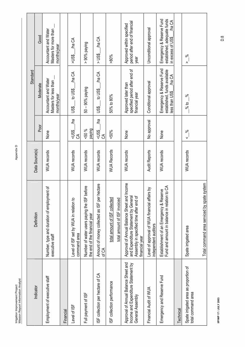
INSTITUTIONAL CAPACITY For the O&M of the irrigation system and its administrative and financial management, the WUA needs sufficient facilities, such as equipped office, means of transport and communication, maps and records, and qualified executive staff, including an Accountant and one or more Water Masters, who are employed for a sufficient period of time. PROPOSED PERFORMANCE INDICATORS
• Level of facilities: - poor: No or only limited number of office equipment (i.e. chair, tables, filing cabinet, typewriter)
- moderate: Fully equipped office without means of transport (i.e. motorbikes) and/or necessary maps and records
- good: Fully equipped office with means of transport (i.e. motorbikes) and/or necessary maps and records
• Employment of executive staff: - poor: No executive staff employed by the WUA
- moderate: Employment of Accountant and Water Master(s) for less than __ months per year - good: Employment of Accountant and Water Master(s) for __ months and more per year
D3 FINANCIAL PERFORMANCE ASSESSMENT A significant concern in irrigation management transfer is that insufficient funds are collected to adequately maintain the infrastructure, leading to a vicious downward spiral of inadequate maintenance, inadequate water delivery, and low levels of fee recovery. As the O&M of the canal systems shall be financed fully by the water users, it is essential for the sustainability of the irrigation system that the WUA is financially autonomous by raising sufficient funds to cover all O&M costs, including expenditures regarding the administrative and financial management of the WUA itself. As the ISF is the most important source of income for the WUA, it shall be set at a level that is sufficient to cover at least the minimum O&M costs. The actual financial situation of the WUA largely depends on its ability to collect the due ISFs and the recovery rate at the percentage of all water having paid their due ISFs fully is the best indicator. Transparency and accountability regarding the financial management of the WUA is also crucial for its functioning and viability. Therefore, it is important that the Annual Balance Sheet and Income & Expenditure Statement is prepared and approved by the General Assembly with the period specified in the WUA Articles of Association. The external audit of the financial records shall reveal if the financial management of the WUA has been carried correctly. For the long-term sustainability of the irrigation system, it is also required that the WUA establish a financial reserve in order to finance emergency repairs, rehabilitation and/or extension works, purchase of vehicles and equipment and/or repayment of bad debts. PROPOSED PERFORMANCE INDICATORS
• Level of ISF: - poor: The WUA has set the level of the ISFs for members at a rate lower than US$ __ per
hectare of the command area1 - moderate: The WUA has set the level of the ISFs for members at a rate between US$ __ and US$
__ per hectare of the command area - good: The WUA has set the level of the ISFs for members at a rate higher than US$ __ per
hectare of the command area
1 A clear definition of the “command area” of spate irrigation systems and their primary canal systems is required.
Irrigation Improvement Project Appendix D Mission Report Information Analyst
IIP/WP 17 / JULY 2003 D.5
• Full payment of ISFs: - poor: Less than 50% of all water users have paid their due ISFs before the end of the financial
year
- moderate: 50% to 89% of all water users have paid their due ISFs before the end of the financial year
- good: 90% and more of all water users have paid their due ISFs before the end of the fin. year
• Amount of money collected as ISF per hectare of the command area: - poor Less than US$ __ per hectare of the command area - moderate: US$ __ to US$15 per hectare of the command area - good: More than US$ __ per hectare of the command area
• Total amount of ISF collected as proportion of total amount of ISF invoiced: - poor: Less than 50% - moderate: 50% to 80% - good: More than 80%
• Approval of Annual Balance Sheet and Income & Expenditure Statement by General Assembly: - poor: No Annual Balance Sheet and Income & Expenditure Statement prepared
- moderate: Annual Balance Sheet and Income & Expenditure Statement are approved by General Assembly later than the period prescribed in the WUA Articles of Association
- good: Annual Balance Sheet and Income and Expenditure Statement is approved be General Assembly within the period prescribed in the WUA Articles of Association
• Financial Audit of WUA: - poor: No approval of financial accounts
- moderate: Conditional approval of financial accounts of WUA - good: Unconditional approval of financial accounts of WUA
• Emergency and Reserve Fund: - poor: The WUA has not established an Emergency and Reserve Fund
- moderate: The WUA has established an Emergency and Reserve Fund with a total amount of less than US$ __ per hectare of the command area
- good: The WUA has established an Emergency and Reserve Fund with a total amount of more than US$ __ per hectare of the command area
D4 TECHNICAL PERFORMANCE ASSESSMENT Operation The equitable distribution of available base and spate flows is an important indicator for the effective operation of the spate irrigation system. An important indicator to assess the performance of the WUA with regard to the operation of the canal system is the area with at least one spate irrigation as a proportion of the total command area of the spate irrigation system. The equitable distribution of base and spate flows could be assessed by comparing the spate irrigated area in the tail section of the primary canal system with the spate irrigated area in the head section. PROPOSED PERFORMANCE INDICATORS
• Spate irrigated area as proportion of total command area: - poor Less than __% of total command area - moderate: ___% to __% of total command area - good: More than __% of total command area
Irrigation Improvement Project Appendix D Mission Report Information Analyst
IIP/WP 17 / JULY 2003 D.6
• Spate irrigated area in tail section of primary canal as proportion of spate irrigated area in head section of primary canal:
- poor Less than __% of spate irrigated area in head section of primary canal - moderate: __% to __% of spate irrigated area in head section of primary canal - good: More than ____% of spate irrigated area in head section of primary canal
Maintenance The performance in relation to maintenance could be assessed through: • Preparation of annual maintenance plan and budget • The amount spent on maintenance work; and • The condition and performance of the irrigation system. With regard to the expenditure on maintenance, the average expenditure per unit command area and maintenance expenditure as a proportion of total expenditure are important indicators. For spate irrigation systems in Yemen total management, the annual maintenance expenditures are in the range of US$ ___ to US$ ___ per ha of the command area.
Proposed Performance Indicators
• Annual maintenance plan and budget prepared and approved by WUA General Assembly: - poor No annual maintenance plan prepared - moderate: Annual maintenance plan and budget prepared but not approved by WUA General
Assembly - good: Annual maintenance plan and budget prepared and approved by WUA General
Assembly
• Annual maintenance budget per unit command area (YR/ha): - poor Less than US$ ___/ha of command area - moderate: US$ ___ to ___/ha of command area - good: Greater than US$ ___/ha of command area
• Annual maintenance expenditure per unit command area (YR/ha): - poor Less than US$ ___/ha of command area - moderate: US$ ___ to ___/ha of command area - good: Greater than US$ ___/ha of command area
• Annual maintenance expenditures to revenue ratio: - poor: Less than 40% - moderate: 40 – 70% - good: Greater than 70%
• Operational capacity of the primary (and secondary) canal system: - poor: Non-operational (less than __% of design capacity) - moderate: Partially operational (between __% and __% of design capacity - good: Fully operational (more than __% of design capacity)
Irrig
atio
n Im
prov
emen
t Pro
ject
A
ppen
dix
D
Mis
sion
Rep
ort I
nfor
mat
ion
Ana
lyst
IIP/W
P 17
/ JU
LY 2
003
D.7
Summ
ary T
able
of Pe
rform
ance
Indic
ators
and P
erfor
manc
e Stan
dard
s
Stan
dard
Ind
icator
De
finitio
n Da
ta So
urce
(s)
Poor
Mo
dera
te Go
od
Institu
tiona
l
WUA
mem
bersh
ip ra
tio
Total
numb
er of
WUA
mem
bers
To
tal nu
mber
of irr
igator
s in s
ervic
e are
a Me
mber
ship
Regis
ter
<25%
25
-50%
>5
0%
Annu
al Ge
nera
l Mee
tings
of G
ener
al As
semb
ly Nu
mber
of A
GM of
Gen
eral
Meeti
ng he
ld an
d lev
el of
repr
esen
tation
by W
UA m
embe
rs W
UA re
cord
s No
ne
At le
ast o
ne bu
t with
<50
%
repr
esen
tation
At
leas
t one
but w
ith >
50%
re
pres
entat
ion
Regu
lar m
eetin
gs of
Man
agem
ent
Boar
d Nu
mber
of m
eetin
gs he
ld du
ring i
rriga
tion
seas
on
WUA
reco
rds
None
Le
ss th
an on
e eac
h mon
th
At le
ast o
ne ea
ch m
onth
Minu
tes of
mee
tings
Ex
isten
ce of
minu
tes of
mee
tings
of th
e Ge
nera
l Ass
embly
and M
anag
emen
t Boa
rd
WUA
reco
rds
None
Mi
nutes
prep
ared
for s
ome
meeti
ngs
Minu
tes pr
epar
ed fo
r all
meeti
ngs
Elec
tions
of m
embe
rs of
Mana
geme
nt Bo
ard
Occu
rrenc
e of e
lectio
ns fo
r mem
bers
of Ma
nage
ment
Boar
d in a
ccor
danc
e with
WUA
Ar
ticles
of A
ssoc
iation
WUA
reco
rds
None
Irr
egula
r elec
tions
, not
in ac
cord
ance
with
Artic
les of
As
socia
tion
Regu
lar el
ectio
ns in
ac
cord
ance
with
Artic
les of
As
socia
tion
Writt
en se
t of In
terna
l Rule
s &
Regu
lation
s Ex
isten
ce of
writt
en se
t of In
terna
l Rule
s &
Regu
lation
s app
rove
d by G
ener
al As
semb
ly W
UA re
cord
s No
ne
Writt
en ru
les, n
ot ap
prov
ed
by G
ener
al As
semb
ly W
ritten
rules
, app
rove
d by
Gene
ral A
ssem
bly
Comm
unica
tion b
etwee
n WUA
and
water
user
s Le
vel o
f com
munic
ation
betw
een W
UA an
d wa
ter us
ers
WUA
reco
rds
None
On
ly W
UA no
tice b
oard
us
ed
Form
al no
tices
at va
riety
of pu
blic p
laces
Enfor
ceme
nt of
sanc
tions
Ex
tent o
f app
licati
on of
sanc
tions
by W
UA on
off
ende
rs W
UA re
cord
s No
ne
Enfor
ceme
nt po
ssibl
e with
he
lp of
polic
e/Loc
al Co
uncil
En
force
ment
poss
ible w
ithou
t he
lp of
polic
e/Loc
al Co
uncil
Reso
lution
of in
terna
l wate
r-rela
ted
confl
icts
Numb
er of
reso
lved i
ntern
al co
nflict
s
Numb
er of
repo
rted i
ntern
al co
nflict
s
WUA
reco
rds
<50%
50
% to
75%
>7
5%
Leve
l of fa
cilitie
s Ex
tent o
f offic
e fac
ilities
, with
or w
ithou
t ad
equa
te me
ans o
f tran
spor
t (mo
torbik
e, bic
ycle)
for f
ield w
ork
WUA
reco
rds
None
or ve
ry lim
ited
Adeq
uatel
y equ
ipped
offic
e, ina
dequ
ate tr
ansp
ort fo
r fiel
d wo
rk
Well
equip
ped o
ffice,
with
adeq
uate
trans
port
for fie
ld wo
rk
Irrig
atio
n Im
prov
emen
t Pro
ject
A
ppen
dix
D
Mis
sion
Rep
ort I
nfor
mat
ion
Ana
lyst
IIP/W
P 17
/ JU
LY 2
003
D.8
Stan
dard
Ind
icator
De
finitio
n Da
ta So
urce
(s)
Poor
Mo
dera
te Go
od
Emplo
ymen
t of e
xecu
tive s
taff
Numb
er, ty
pe an
d dur
ation
of em
ploym
ent o
f ex
ecuti
ve st
aff
WUA
reco
rds
None
Ac
coun
tant a
nd W
ater
Maste
rs for
less
than
__
month
s/yea
r
Acco
untan
t and
Wate
r Ma
sters
for m
ore t
han _
_ mo
nths/y
ear
Finan
cial
Leve
l of IS
F Le
vel o
f ISF
set b
y WUA
in re
lation
to
comm
and a
rea
WUA
reco
rds
<US$
___/h
a CA
US
$___
to U
S$__
_/ha C
A >U
S$__
_/ha C
A
Full p
ayme
nt of
ISF
Numb
er of
wate
r use
rs pa
ying t
he IS
F be
fore
the en
d of th
e fina
ncial
year
W
UA re
cord
s <5
0 %
payin
g 50
– 90
% pa
ying
> 90
% pa
ying
ISF
colle
ction
per h
ectar
e of C
A Am
ount
of mo
ney c
ollec
ted as
ISF
per h
ectar
e of
CA
WUA
reco
rds
<US$
___/h
a CA
US
$___
to U
S$__
_/ha C
A >
US$_
__/ha
CA
ISF
colle
ction
perfo
rman
ce
total
amou
nt of
ISF
colle
cted
total
amou
nt of
ISF
invoic
ed
WUA
Rec
ords
<5
0%
50%
to 80
%
>80%
Appr
oval
of An
nual
Balan
ce S
heet
and
Incom
e and
Exp
endit
ure S
tatem
ent b
y Ge
nera
l Ass
embly
Appr
oval
of An
nual
Balan
ce S
heet
and I
ncom
e an
d Exp
endit
ure S
tatem
ent b
y Gen
eral
Asse
mbly
in sp
ecifie
d tim
e afte
r end
of
finan
cial y
ear
WUA
reco
rds
None
Ap
prov
ed la
ter th
an
spec
ified p
eriod
after
end o
f fin
ancia
l yea
r
Appr
oved
with
in sp
ecifie
d pe
riod a
fter e
nd of
finan
cial
year
Finan
cial A
udit o
f WUA
Le
vel o
f app
rova
l of W
UA fin
ancia
l affa
irs by
ind
epen
dent
audit
ors
Audit
Rep
orts
No ap
prov
al Co
nditio
nal a
ppro
val
Unco
nditio
nal a
ppro
val
Emer
genc
y and
Res
erve
Fun
d Es
tablis
hmen
t of a
n Eme
rgen
cy &
Res
erve
Fu
nd an
d amo
unt in
balan
ce in
relat
ion to
CA
WUA
reco
rds
None
Em
erge
ncy &
Res
erve
Fun
d es
tablis
hed,
funds
avail
able
less t
han U
S$__
_/ha C
A
Emer
genc
y & R
eser
ve F
und
estab
lishe
d, ad
equa
te fun
ds
in ex
cess
of U
S$__
_/ha C
A
Tech
nical
Spate
irriga
ted ar
ea as
prop
ortio
n of
total
comm
and a
rea
Spate
irriga
ted ar
ea
Total
comm
and a
rea s
ervic
ed by
spate
syste
m
WUA
reco
rds
<__%
__
% to
__%
>_
_%
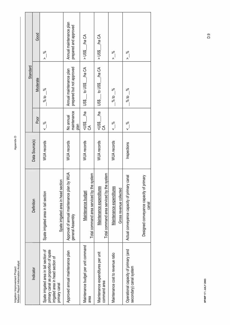
Irrig
atio
n Im
prov
emen
t Pro
ject
A
ppen
dix
D
Mis
sion
Rep
ort I
nfor
mat
ion
Ana
lyst
IIP/W
P 17
/ JU
LY 2
003
D.9
Stan
dard
Ind
icator
De
finitio
n Da
ta So
urce
(s)
Poor
Mo
dera
te Go
od
Spate
irriga
ted ar
ea in
tail s
ectio
n of
prim
ary c
anal
as pr
opor
tion o
f spa
te irr
igated
area
in he
ad se
ction
of
prim
ary c
anal
Spate
irriga
ted ar
ea in
tail s
ectio
n
Spate
irriga
ted ar
ea in
head
secti
on
WUA
reco
rds
<__%
__
% to
__%
>_
_%
Appr
oved
annu
al ma
inten
ance
plan
Ap
prov
al of
annu
al ma
inten
ance
plan
by W
UA
gene
ral A
ssem
bly
WUA
reco
rds
No an
nual
maint
enan
ce
plan
Annu
al ma
inten
ance
plan
pr
epar
ed bu
t not
appr
oved
An
nual
maint
enan
ce pl
an
prep
ared
and a
ppro
ved
Maint
enan
ce bu
dget
per u
nit co
mman
d ar
ea
Maint
enan
ce bu
dget
Total
comm
and a
rea s
ervic
ed by
the s
ystem
W
UA re
cord
s <U
S$__
_/ha
CA
US$_
__ to
US$
___/h
a CA
> US
$___
/ha C
A
Maint
enan
ce ex
pend
iture
s per
unit
comm
and a
rea
Maint
enan
ce ex
pend
iture
s To
tal co
mman
d are
a ser
viced
by th
e sys
tem
WUA
reco
rds
<US$
___/h
a CA
US
$___
to U
S$__
_/ha C
A >
US$_
__/ha
CA
Maint
enan
ce co
st to
reve
nue r
atio
Maint
enan
ce ex
pend
iture
s Gr
oss r
even
ue co
llecte
d W
UA re
cord
s <_
_%
__%
to __
%
>__%
Oper
ation
al ca
pacit
y of p
rimar
y (an
d se
cond
ary)
cana
l sys
tem
Actua
l con
veya
nce c
apac
ity of
prim
ary c
anal
Desig
ned c
onve
yanc
e cap
acity
of pr
imar
y ca
nal
Inspe
ction
s <_
_%
__%
to __
%
>__%
Irrigation Improvement Project Appendix D Mission Report Information Analyst
IIP/WP 17 / JULY 2003 D.10
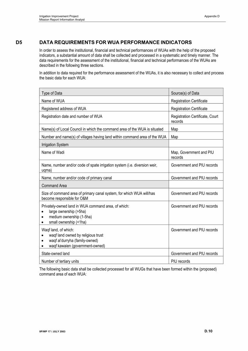
D5 DATA REQUIREMENTS FOR WUA PERFORMANCE INDICATORS In order to assess the institutional, financial and technical performances of WUAs with the help of the proposed indicators, a substantial amount of data shall be collected and processed in a systematic and timely manner. The data requirements for the assessment of the institutional, financial and technical performances of the WUAs are described in the following three sections. In addition to data required for the performance assessment of the WUAs, it is also necessary to collect and process the basic data for each WUA:
Type of Data Source(s) of Data
Name of WUA Registration Certificate
Registered address of WUA Registration Certificate
Registration date and number of WUA Registration Certificate, Court records
Name(s) of Local Council in which the command area of the WUA is situated Map
Number and name(s) of villages having land within command area of the WUA Map
Irrigation System
Name of Wadi Map, Government and PIU records
Name, number and/or code of spate irrigation system (i.e. diversion weir, uqma)
Government and PIU records
Name, number and/or code of primary canal Government and PIU records
Command Area
Size of command area of primary canal system, for which WUA will/has become responsible for O&M
Government and PIU records
Privately-owned land in WUA command area, of which: • large ownership (>5ha) • medium ownership (1-5ha) • small ownership (<1ha)
Government and PIU records
Waqf land, of which: • waqf land owned by religious trust • waqf al’durryha (family-owned) • waqf kawaien (government-owned)
Government and PIU records
State-owned land Government and PIU records
Number of tertiary units PIU records
The following basic data shall be collected processed for all WUGs that have been formed within the (proposed) command area of each WUA:
Irrigation Improvement Project Appendix D Mission Report Information Analyst
IIP/WP 17 / JULY 2003 D.11
Type of Data Source(s) of Data
Name of WUG PIU records
Name, number and/or code of canal(s) PIU records
Size of area, for which WUG has been formed PIU records
Number of farmers cultivating land within command area of WUG, including: • owner-operators • sharecroppers • tenants • ‘beneficiaries’
PIU records
Number of female farmers/female-headed households cultivating land within command area of WUG
PIU records
Number of WUG members PIU records
Date of formation PIU records
Name of WUG Leader PIU records
DATA REQUIREMENTS FOR INSTITUTIONAL PERFORMANCE ASSESSMENT
Type of Data Source(s) of Data
Representation:
Number of farmers cultivating land within command area of WUA, including: • owner-operators • sharecroppers • tenants • ‘beneficiaries’
PIU records
Number of female farmers/female-headed households cultivating land within command area of WUA
PIU records
Number of non-operating landholders PIU records
Number of WUA members WUA Membership Register
Transparency and Accountability
Number of members of the WUA General Assembly WUA records
Number of WUA General Assembly Meetings conducted per year WUA records, inspections
Number of WUA General Assembly members attended each meeting of WUA General Assembly
WUA records, inspections
Number of members of the WUA Management Board WUA records
Number of WUA Management Board meetings conducted during irrigation season (April-September)
WUA records, inspections
Number of WUA Management Board members attended each meeting of WUA Management Board
WUA records, inspections
Number of minutes of meetings prepared WUA records
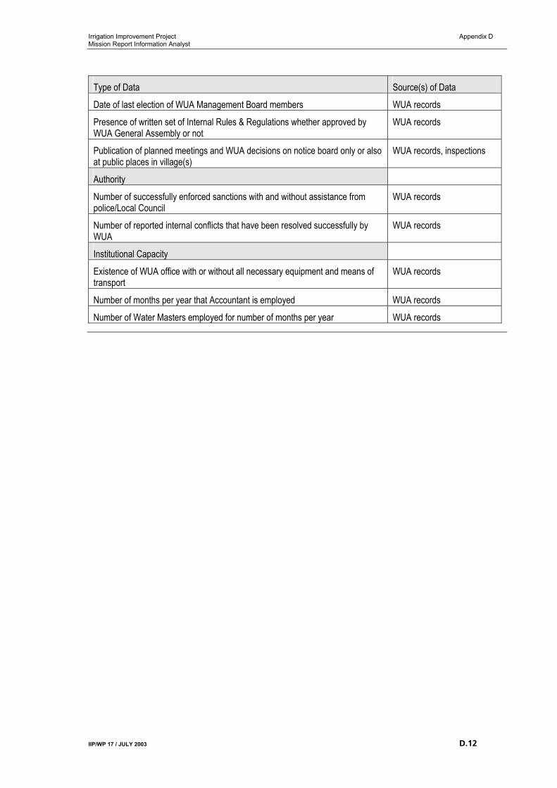
Irrigation Improvement Project Appendix D Mission Report Information Analyst
IIP/WP 17 / JULY 2003 D.12
Type of Data Source(s) of Data
Date of last election of WUA Management Board members WUA records
Presence of written set of Internal Rules & Regulations whether approved by WUA General Assembly or not
WUA records
Publication of planned meetings and WUA decisions on notice board only or also at public places in village(s)
WUA records, inspections
Authority
Number of successfully enforced sanctions with and without assistance from police/Local Council
WUA records
Number of reported internal conflicts that have been resolved successfully by WUA
WUA records
Institutional Capacity
Existence of WUA office with or without all necessary equipment and means of transport
WUA records
Number of months per year that Accountant is employed WUA records
Number of Water Masters employed for number of months per year WUA records
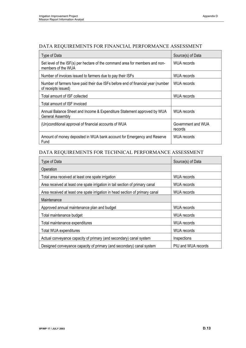
Irrigation Improvement Project Appendix D Mission Report Information Analyst
IIP/WP 17 / JULY 2003 D.13
DATA REQUIREMENTS FOR FINANCIAL PERFORMANCE ASSESSMENT
Type of Data Source(s) of Data
Set level of the ISF(s) per hectare of the command area for members and non-members of the WUA
WUA records
Number of invoices issued to farmers due to pay their ISFs WUA records
Number of farmers have paid their due ISFs before end of financial year (number of receipts issued)
WUA records
Total amount of ISF collected WUA records
Total amount of ISF invoiced
Annual Balance Sheet and Income & Expenditure Statement approved by WUA General Assembly
WUA records
(Un)conditional approval of financial accounts of WUA Government and WUA records
Amount of money deposited in WUA bank account for Emergency and Reserve Fund
WUA records
DATA REQUIREMENTS FOR TECHNICAL PERFORMANCE ASSESSMENT
Type of Data Source(s) of Data
Operation
Total area received at least one spate irrigation WUA records
Area received at least one spate irrigation in tail section of primary canal WUA records
Area received at least one spate irrigation in head section of primary canal WUA records
Maintenance
Approved annual maintenance plan and budget WUA records
Total maintenance budget WUA records
Total maintenance expenditures WUA records
Total WUA expenditures WUA records
Actual conveyance capacity of primary (and secondary) canal system Inspections
Designed conveyance capacity of primary (and secondary) canal system PIU and WUA records
Irrigation Improvement Project Appendix E Mission Report Information Analyst
IIP/WP 17 / JULY 2003 E.1
I APPENDIX E
I DATA DESCRIPTION PIM PERFORMANCE
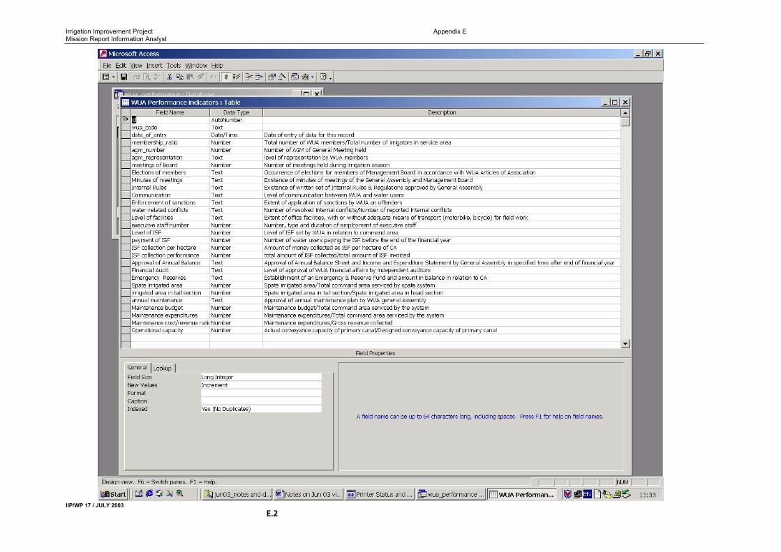
Irrigation Improvement Project Appendix E Mission Report Information Analyst
IIP/WP 17 / JULY 2003 E.2

Progress Report MIS
IIP/WP 17 / JULY 2003 E.I.1

Irrigation Improvement Project Progress Report MIS]
I.1 IIP/WP/FEBRUARY 2003