Embed Size (px)
Citation preview

Stonehouse
Lemont
InglewoodSwanston
Ravensdale
LittleSwanport
Little SwanportCatchment
Stonehouse
Lemont
InnglewoodSSwwwanston
Ravensdallee
LittleSwanport
Little SwanpoorrtCatchmentt
Base image by TASMAP, © State of Tasmania
Little Swanport Catchment Plan“Working Together to look after Our Catchment & Our Community”
2010 - 2015
Little Swanport Catchment Plan Implementation Committee

Citation:Little Swanport Catchment Plan Implementation Committee. 2010.Little Swanport Catchment Plan 2010-2015.Little Swanport, Tasmania, Australia.

3PRINTED ON 50% RECYCLED, ACID FREE, AUSTRALIAN MADE PAPER
Little Swanport Catchment Management Plan“Working Together to look after Our Catchment & Our Community”
Contents
Acknowledgements................................................ 4
Introduction ........................................................... 5
Our Catchment ...................................................... 7
Review of the LSCMP .......................................... 11
Community Care .................................................. 13
Water ..................................................................... 15
Soils ....................................................................... 21
Fire management ................................................. 25
Native Vegetation ................................................ 28
Native Vegetation Risk Assessment .................. 30
Weeds .................................................................... 32
Estuary/Coastal Marine ...................................... 36
Threatened Species .............................................. 40
Game Management ............................................. 43
Aboriginal Heritage & Culture............................ 44
References & Bibliography .................................. 45
Contact Information: ........................................... 45

4
Acknowledgements
This revision of the Little Swanport Catchment Plan (2003)would not have been possible without:
o The ongoing support of Glamorgan Spring Bay and Southern Midlands Councils, and their dedicated staff.
o The support of the Glamorgan Spring Bay NRM Committee.
o The commitment, guidance, and financial investment from NRM South.
o The original contributions of Tom Teniswood, Ruth Hall and Jodie Epper.
o The Australian Government - Natural Heritage Trust 2.
o The volunteers that form the Little Swanport Catchment Management Plan Implementation Committee.
o The support, knowledge and guidance provided by a number of government and/or private organisations that assist land managers and facilitators. In particular:
Department of Primary Industry and Water (DPIPWE)Information Land Services - TASMAP Tasmanian Aquaculture and Fisheries Institute (TAFI)Fisheries Research and Development Corporation (FRDC)Marine ResourcesForestry TasmaniaDepartment of DefenceTasmanian Parks & Wildlife (PWS)
A special thank you also to the following individuals who provided the
introductions throughout this document:
Dr Adam Uytendaal – Manager, Tasmanian Environmental Flows Project
Darren Kidd – Soils Officer DPIPWE
David Tucker – Glamorgan Spring Bay Council NRM Committee
Professor Jamie Kirkpatrick – University of Tasmania
Helen Geard & Mel Kelly – NRM officers: Southern Midlands & Glamorgan Spring Bay Council
Dr Christine Crawford – Tasmanian Aquaculture & Fisheries Institute
Matt Byrne – Game Management Services Unit DPIPWE
Paul Dawson – Aboriginal NRM Support Officer - NRM South
Sandy Dunbabin – Catchment Coordinator (07/08) and Local Resident
Dr Phil Bell - Threatnened Species Section, Biodiversity Conservation Branch DPIPWE
Unless otherwise acknowledged all photographs courtesy of Sandy Dunbabin, Mel Kelly and the Catchments to Coasts program

5
Introduction
This document is a review of the original Little Swanport Catchment Plan launched in 2003.
It is a guide for interested land managers.
The plan aims to:
o give an overview of the catchment’s natural, economic and social structure;
o highlight some possible risks to its assets;
o provide some advice for best practice natural resource management; and
o present a framework that may allow on ground works to proceed in an integrated and coordinated way.
The plan has been produced by the NRM staff of Glamorgan Spring Bay and Southern Midlands Council in consultation with the voluntary members of the Little Swanport Catchment Plan Implementation Committee. Workshops were held with technical advisors using a risk assessment approach.
The draft reviewed plan was endorsed by both Councils prior to a public consultation period. A public meeting presenting the draft reviewed plan and inviting feedback was held in mid 2009. Any feedback recieved was considered by the committee for inclusion in the final plan.
It is a publication written by the catchment community for the catchment community.
Actions identified in the plan have been considered in context of being within the capacity of a voluntary committee to progress, with support from paid professional staff from the Catchment to Coasts program.
*It is important to note that the Little Swanport Catchment Management Plan is in no way a regulatory or statutory document. Nor is it intended as a comment on past management practices.
“Tasmania must continue to be a leader in best environmental practice, not just because it protects the integrity of ecosystems and the environment generally, but because increasingly these will provide market benefits in the future…”
(Nixon 2007)
6
Key Achievements of the Little Swanport Catchment Management Plan Implementation Committee 2003 - 2010
• Continued to provide a forum for information exchange between Committee members and other organisations involved in projects and activities relevant to the catchment.
• Participated in the development of the State Government ‘Water Management Plan’ for the catchment.
• Developed and implemented the Sustainable Grazing on Saline Lands salinity trial in the lower catchment.
• Accessed and distributed funding on behalf of landholders for riparian fencing.
• Accessed funding for and developed a Community Water Quality Monitoring program.
• Maintained membership of the Tasmanian Landcare Association.
• Worked in partnership with the GSB and Southern Midlands Council in implementing the NRM South funded ‘Whole of Catchment and Whole of Ecosystem’ planning model project.
• Assisted with the implementation of the FRDC / LWA ‘Water Use Across A Catchment’ project.
• Organised community events including the ‘Swanston Road Bushwalk’ and the ‘Woodsdale Hall Bush Dance’.
• Facilitated funding opportunities for landholders via the NRM Incentives program for riparian / saltmarsh fencing and weed control in priority vegetation.
• Facilitated participation of the upper catchment farmers group in the National Landcare / Serve Ag ‘Sustainable Agriculture’ project.
• Communicated NRM initiatives and activities to the entire catchment community via mailouts and three bi-annual newsletters.
• Facilitated the five year review of the Catchment Management Plan involving two workshops with technical advisors assisting.
• Linked in with the Council Weed Management Plans by organising a Serrated Tussock (and Salinity) Field Day.
• Formed partnerships with the Department of Defence and the Tasmanian Fire Service Volunteers to progress on ground works.
• Provided support for the Property Management Planning program run in the area by NRM South.
• Winners of the Toshiba Community Group Award at the Tasmanian Landcare Conference & Awards 2009.

7
Little SwanportCatchment
Stonehouse
Lemont
Inglewood
Woodsdale
SwanstonRavensdale
Mayeld
LittleSwanport
NorthernMidlands
SouthernMidlands
GlamorganSpring Bay
AUSTRALIA
TASMANIA
Our Catchment
The Little Swanport Catchment is situated on the central east coast of Tasmania, Australia.
It is governed locally by Glamorgan Spring Bay Council in the east and Southern Midlands Council inland. It lies within the Southern NRM region - one of three NRM regions in Tasmania
The catchment area is approximately 87,600 ha and has an estimated population of 500-700 permanent residents. The catchment comprises of approximately 300 separateownership titles.

8
Geographically, the catchment can bedivided into 3 broad scale landscapes:
The Upper Catchment
The upper catchment is a plateau interposed with hills.
It is home to a small number of large hectare traditional dry land grazing properties and a number of smaller residential and mixed farming holdings.
Heritage listed family properties like “Stonehenge”, “Inglewood”, “Fonthill” and “Ashgrove” are found in the upper catchment.
Woodsdale is the social centre of the smaller scale mixed farming operations and the historic town of Oatlands services the region.
Primary Production is the main industry in this area: wool, beef, prime lamb, and some vegetable, grain and seed cropping.
In recent years there has been an increasing level of plantation forestry.
Our Catchment

9
The Mid-Catchment
The mid-catchment is primarily forested. It is mountainous and descends to the lower catchment.
There is a combination of old growth and regrowth forest in this area. Some under control of the Defence Department, part of the extensive Buckland Military Training Facility. There is also State Forest, managed by Forestry Tasmania, and large areas of private land.
Swanston, in the centre of the catchment, was proclaimed a town during early settlement days and once boasted 2 public bars. However, these days the area is farmed. The Swanston Road was formed in 1836 to service the growing district of Swanport (Swansea) which was administered from Oatlands. It became the main route through to the East Coast from the Midlands for the early European settlers.
There are large private nature reserves in the mid catchment, as well as three public Conservation Areas: Butlers Ridge, Pepper Creek and Little Swanport Nature Reserves.

10
Lower Catchment
The lower-catchment is relatively flat low-lying agricultural land.
It is here that the Little Swanport River meets the sea and land use is more diverse with large coastal grazing properties, residential/holiday settlements, tourist accommodation, and olive and oyster farming enterprises.
The mouth of the Little Swanport River (estuary) is a popular spot for recreational fishing and other seaside holiday activities. It supports several successful oyster farming enterprises.
Pontypool and Saltworks house a cluster of permanent and semi-permanent ‘lifestyle’ residents: 50% retired or semi-retired. The peak summer population in this area can be up to 3 times that of the permanent population.
Our Catchment

11
Review of the 2003 Little Swanport Catchment Management Plan
Two workshops were held by the Little Swanport Catchment Management Plan Implementation Committee along with other key stakeholders and providers of technical input and support.
These events were professionally facilitated and were held at the old Woodsdale School and the Buckland Military Training Facility both within the catchment.
A risk assessment approach to reviewing the plan was trialled. This was undertaken in light of any new governance, scientific and technical knowledge discussed by those present. The many changes that have occurred in the catchment since the plan was finalised in 2003 were also considered in the discussion.
This approach gives a formalised means of assessing risks to the many assets in the catchment. It also enables past and current actions to address these risks to be considered prior to determining actions to reduce risks or to find out further information.
A number of cross-cutting issues have emerged since this review process was undertaken. An example is an increasing understanding of climate change and the emerging implications such as sea level rise and carbon offsets trading. Already these issues have implications for the catchment and will require an adaptive management approach to be condidered when progressing actions in the plan.
The revised plan provides only a snapshot of the values and issues in the catchment. Much detail in the 2003 plan is still relevant hence why it remains one of a number of valuable reference documents.
A broader public consultation of the revised plan enabled other stakeholders and catchment community members to input in the revision of the plan.
Recommended Action:o Compile a DVD with electronic copies of reference documents including
links to websites of relevance to the Little Swanport Catchment.

12
Table 1: Likelihood of a risk happeningLikelihood Score Definition
Remote 1 Never heard of, but not impossible
Rare 2 May occur in exceptional circumstances
Unlikely 3 Uncommon, but has been known to occur
Possible 4 Some evidence to suggest this may possibly occur
Occasional 5 May occur
Likely 6 It is expected to occur
Table 2: Consequence if the risk does occurConsequence Score Definition
Negligible 0 Very insignificant impacts. Unlikely to be measurable
Minor 1 Possibly detectable but minimal impact on structure/function
Moderate 2 Maximum acceptable level of impact - recovery measured in months or years
Severe 3 Will result in wider and longer term impacts - recovery measured in years
Major 4 Very serious impacts with relatively long time frame likely to be needed to restore to an acceptable level - recovery measured in years to decades
Catastrophic 5 Widespread and permanent/irreversable damage or loss will occur - unlikely to ever be fixed
Table 3: Risk ranking = likelihood x consequenceC O N S E Q U E N C E
Likelihood Negligible Minor Moderate Severe Major Catastrophic
Remote 0 1 2 3 4 5
Rare 0 2 4 6 8 10
Unlikely 0 3 6 9 12 15
Possible 0 4 8 12 16 20
Occasional 0 5 10 15 20 25
Likely 0 6 12 18 24 30
Table 4: Risk ranking categoryScore Category
0 = Negligible risk
1 - 6 = Low risk
8 - 12 = Moderate risk
15 - 18 = High risk
20 - 30 = Extreme risk
Source: Seafood Services Australia (2004)

13
Community Care
Caring for the natural resource needs of any river catchment should also be about caring for the people that live, work and play within it.
Effective ‘on ground’ NRM progress is best initiated by local land managers that are well informed, well supported and fully committed to the task at hand.
In the past, property owners have become frustrated by the short term nature of government funded projects driven from ‘the top down’. It has been a hit and miss approach with constant changes in personnel, logos, expectations, etc.
In many instances, projects have been managed by strangers to the catchment with little knowledge and/or understanding of the region. Often, this has resulted in aims not being met or monies wasted. Boxes have been ticked with little real change in the landscape.
Extensive research findings have remained housed outside the catchment with no practical dissemination or implementation.
Expectations put on volunteers in our catchment over the last decade has been very high. Effective and enthusiastic individuals began hanging up their NRM boots. They were exhausted.
Our committee believes that successful, strategic, long term NRM progress can be made by working with, rather than against, a community.
Staff assisting with this progress should be individuals (or brands) that landowners know and trust - local paid personnel taking a genuine interest in a property manager’s situation and working along side them.
By providing increased support at a grass roots level for a much longer period of time we may be able to build up the essential trust required to facilitate significant change.

14
Over the past 18 months an extension officer was funded to assist land managers in the Little Swanport Catchment. This has allowed a variety of land managers to become re-engaged in NRM acitivities.
Having a local facilitator has allowed them to access information relative to their business or interests, talk honestly with someone about their strengths and weaknesses, discuss funding and/or project options, implement on ground works and begin to take some small but significant steps towards the better environmental management of their land.
Sandy DunbabinCatchment ExtensionGlamorgan Spring Bay Council
Recommended Actions
o Encourage NRM South, state and local government to continue to support the Catchment Coordinator position and that of an independent facilitator (as required) eg. through the support of the ‘Glamorgan Spring Bay Catchment To Coast’ project
o Develop clear roles and responsibilities and protocols for the Committee eg. terms of reference
o Committee to develop a Terms of Reference.
o Develop communication protocols with other organisations and agencies undertaking activities in the catchment eg. researchers
o Subject to available resources undertake a public consultation of the redraft catchment management plan
o Continue to communicate the activities of the committee through the catchment newsletter
o Work with individuals and community groups to address issues of concern such as littering and illegal rubbish dumping. eg. Support Clean Up Australia Day events and encourage participation in Bushwatch.
Community Care continued

15
Water Overview
The flow of water throughout the Little Swanport Catchment is highly variable.
Periods of low to zero flow during warmer months are a natural characteristic of the river.
Like most catchments on Tasmania’s East Coast, the river system can be described as ‘flashy’; it responds quickly to rainfall events with rapid increases and decreases in water level and flow.
Generally, water quality in this system, is most at risk in the upper and middle catchment where salinity and nutrient runoff can be significant.
The drainage system in the upper catchment has been modified over time, and this, coupled with past land clearing practices, can result in higher summer water temperatures, lower dissolved oxygen levels and increased groundwater influences on stream salinity.
Green Tier Creek
Eastern Marshes Rivulet
Stonehouse
Lemont
InglewoodSwanston
Ravensdale
LittleSwanport
Little SwanportCatchment
Little Swanport RiverCrichton Creek
Nut
ting Gard
en Rivu
let
Pine Rivulet
Pepper Creek
Ravensd
ale R
ivulet
Little Swanport River
Base image by TASMAP, © State of Tasmania
Diagram above shows the major tributaries of the Little Swanport Catchment
16
The intermittent nature of flow throughout the catchment exacerbates these factors.
After rains, water quality downstream in the middle and lower catchment improves.
Inflows from relatively undisturbed tributaries help improve the water quality – a dilution effect occurs. Good riparian vegetation in this area reduces inputs of sediment, salts and nutrients.
During periods of high water flow, turbidity levels in the Little Swanport River increase.
‘Turbidity’ refers to the amount of suspended material in the water – ie, organic (plant material, algae) or inorganic (clay, silt etc).
At times of increased flow the transport of nutrients and suspended sediment throughout the catchment is significant.
Land clearing, reduction of riparian vegetation and/or stock access along river banks can lead to increased erosion and greater mobilization of this material into the river system.
Temperature influences the functioning of aquatic ecosystems eg. fish, plants & invertebrates (water bugs).
Riparian vegetation is one of the most important factors governing temperature fluctuations in river systems. Removal of this vegetation, removes shade.
High water temperatures that can lead to stress in some species of fish and aquatic organisms as well as diminished dissolved oxygen levels have been recorded at times during the summer in the Little Swanport River. Often these high readings coincide with warm periods of weather in areas of reduced riparian vegetation.
Water Overview continued

17
Conserving remnant riparian vegetation and trying to increase streamside verge and overhanging vegetation is an effective way to reduce fluctuations and extremes in water temperature.
Stream pH levels in the Little Swanport catchment are generally slightly alkaline, with values often ranging from 7.5 to 8.5. These levels are influenced by geology, soil chemistry, vegetation and land use practice. Once again, too much variance can be a concern.
Increased levels of nutrients, such as phosphorus and nitrogen, in rivers can lead to degradation in water quality through the formation of algal blooms and large increases in aquatic plant biomass. For example, over use of phosphorus and/or nitrogen based fertiliser may cause nuisance algal blooms.
Any re-vegetation projects in the upper catchment are highly beneficial to the overall health of the stream system.
Dr Adam Uytendaal Senior Aquatic Ecologist Water Resources DPIPWE

18
Water Quality & Water Quantity Risk Assessment
Activ
ity
Risk
LikeL
ihoo
dco
nseq
uenc
eRi
sk RA
nkin
gFu
tuRe
BARR
ieRs /
Actio
nsPo
ssiB
Le Fu
tuRe
BARR
ieRs/
Activ
ities
to
Redu
ce Ri
skOv
er ex
tracti
on of
wat
er fr
om th
e rive
r an
d trib
utar
ies.
Impa
cts on
in st
ream
, ripa
rian,
we
tland
and e
stuar
ine ec
ology
.5*
4**
20(E
xtre
me R
isk)
•De
velop
men
t and
imple
men
tatio
n of t
he
Wat
er M
anag
emen
t Plan
(WM
P).
•La
ndca
re fu
nded
Susta
inable
Graz
ing
Proje
ct.
•En
cour
age p
artic
ipatio
n in t
he re
view
of th
e WMP
.•
Supp
ort r
esea
rch in
to re
levan
t eco
logica
l elem
ents
of th
e sys
tem
to he
lp inf
orm
the r
eview
eg. fl
ow
requir
emen
ts of
wetl
ands
.•
Supp
ort r
eview
into
impa
cts of
clim
ate c
hang
e on
wate
r man
agem
ent.
•En
cour
age r
egula
r com
mun
icatio
n bet
ween
the
Wat
er M
anag
emen
t Plan
ning S
ectio
n of D
PIPW
E, th
e LS
CMPI
C and
the b
road
er ca
tchm
ent c
omm
unity
.St
ock a
ccess
to w
ater
ways
.Ero
sion a
nd fa
ecal
cont
amina
tion.
52
10(M
oder
ate R
isk)
• Fe
ncing
has a
lread
y bee
n und
erta
ken a
long
vario
us se
ction
s of t
he riv
er an
d trib
utar
ies
as a
resu
lt of
prev
ious f
undin
g pro
gram
s.•
Ince
ntive
s for
fenc
ing an
d off-
strea
m w
ater
po
ints f
or st
ock a
re cu
rrent
ly av
ailab
le.•
The C
atch
men
t Coo
rdina
tor p
ositi
on
curre
ntly
assis
ts in
facilit
ating
the l
inkag
e be
twee
n fun
ding o
ppor
tunit
ies fo
r fen
cing
and i
nter
este
d lan
dhold
ers.
Cont
inue t
he Ca
tchm
ent C
oord
inato
r pos
ition
to
facilit
ate:
•A s
trate
gic re
view
of fe
ncing
requ
irem
ents
to
dete
rmine
prior
ities
area
s to b
e fen
ced (
this
is to
m
axim
ise th
e effe
ctive
ness
of pu
blic a
nd pr
ivate
inv
estm
ent i
n on-
grou
nd w
orks
);•
Supp
ort f
or la
ndho
lders
in ac
cessi
ng fu
nding
for
fencin
g and
ongo
ing m
anag
emen
t of f
ence
d are
as.
•Co
ntinu
ed pr
oduc
tion o
f the
Catch
men
t New
slette
r to
com
mun
icate
with
land
man
ager
s the
late
st NR
M
infor
mat
ion an
d opp
ortu
nities
.Ro
ads c
lose t
o wat
erwa
ys or
alon
g dr
ainag
e line
s.Im
pacts
on w
ater
quali
ty du
e to
sedim
enta
tion a
nd po
llutio
n.3
13
(Low
Risk
)Co
de of
Fore
st Pr
actic
e – re
quire
men
t to
ensu
re th
at bu
ilding
of fo
restr
y roa
ds ha
s m
inim
al im
pact
on w
ater
quali
ty.
•Re
ques
t a pr
esen
tatio
n fro
m th
e For
est P
racti
ces
Auth
ority
on th
e Cod
e;•
Enco
urag
e a re
view
of ex
isting
road
s in t
he
catch
men
t tha
t wer
e buil
t prio
r to t
he Co
de.
•En
cour
age C
ounc
il/s t
o dev
elop p
olicie
s and
pr
oced
ures
deta
iling a
nd do
cum
entin
g bes
t pra
ctice
in
road
desig
n and
main
tena
nce.
Stoc
k gra
zing m
anag
emen
t.Im
pacts
on w
ater
quali
ty
due t
o ero
sion a
nd fa
ecal
cont
amina
tion.
43
12(M
oder
ate R
isk)
Land
care
fund
ed Su
staina
ble Gr
azing
Proje
ct.
Cont
inue p
rodu
cing t
he Ca
tchm
ent N
ewsle
tter
com
mun
icate
with
land
man
ager
s the
late
st NR
M
infor
mat
ion an
d opp
ortu
nities
.Re
mov
al of
/ im
pact
on rip
arian
area
s.Im
pacts
on w
ater
quali
ty
for e
xam
ple du
e to r
educ
ed
filtra
tion a
nd in
creas
es in
wat
er
tem
pera
ture.
54
20(E
xtre
me R
isk)
Land
care
fund
ed Su
staina
ble Gr
azing
Proje
ct.Co
ntinu
e the
Catch
men
t Coo
rdina
tor p
ositi
on to
co
ntinu
e pro
ducin
g the
Catch
men
t New
slette
r co
mm
unica
te w
ith la
nd m
anag
ers t
he va
lue of
ripar
ian
vege
tatio
n and
supp
ort t
hem
in ac
cessi
ng op
portu
nities
to
prot
ect i
t, an
d im
prov
e con
dition
.

19
Activ
ity
Risk
LikeL
ihoo
dco
nseq
uenc
eRi
sk RA
nkin
gFu
tuRe
BARR
ieRs /
Actio
nsPo
ssiB
Le Fu
tuRe
BARR
ieRs/
Activ
ities
to
Redu
ce Ri
skM
inim
al or
unco
ordin
ated
and
unco
mm
unica
ted w
ater
quali
ty
mon
itorin
g pro
gram
.
Limite
d und
ersta
nding
abou
t th
e pas
t, cu
rrent
and f
utur
e on
going
healt
h of t
he riv
er an
d th
e im
pacts
of va
rious
activ
ities
on
wat
er qu
ality.
53
15(H
igh Ri
sk)
• M
uch d
ata h
as be
en co
llecte
d and
co
mm
unica
ted i
n an o
ppor
tunis
tic w
ay ov
er
a num
ber o
f yea
rs.•
LSCM
PIC h
as ob
taine
d fun
ding f
or
mon
itorin
g equ
ipmen
t and
has d
evelo
ped
a mon
itorin
g plan
invo
lving
the c
omm
unity
wi
th su
ppor
t fro
m D
PIPW
E tec
hnica
l sp
ecial
ists.
• Co
ntinu
e the
Catch
men
t Coo
rdina
tor p
ositi
on to
wor
k as
a lia
ison b
etwe
en pr
ofes
siona
ls in
DPIP
WE,
othe
r or
ganis
ation
s inv
olved
in w
ater
quali
ty m
onito
ring,
NRM
Sout
h and
the c
omm
unity
to pr
ogre
ss a
coor
dinat
ion an
d com
mun
icatio
n stra
tegy
for c
urre
nt
and f
utur
e mon
itorin
g.•
Utilis
e the
Catch
men
t New
slette
r to c
omm
unica
te
resu
lts of
wat
er qu
ality
mon
itorin
g acti
vities
.Ov
er ex
tracti
on of
wat
er du
e to l
imite
d kn
owled
ge of
the h
ydro
logy o
f the
ca
tchm
ent.
Impa
cts on
in st
ream
, ripa
rian
and e
stuar
ine ec
ology
.4
416
(High
Risk
)An
initi
al hy
drolo
gical
study
has b
een
unde
rtake
n.•
Cont
inue t
o eng
age w
ith re
sear
cher
s and
relev
ant
agen
cies t
o inc
reas
e our
unde
rstan
ding o
f the
hy
drolo
gy of
the c
atch
men
t, pa
rticu
larly
in lig
ht of
cli
mat
e cha
nge.
•Ut
ilise t
he Ca
tchm
ent t
o Coa
st ne
wslet
ter t
o co
mm
unica
te th
is kn
owled
ge.
Relia
nce o
n and
incre
ased
build
ing of
sm
all w
ater
holes
.Po
ssibil
ity of
cum
ulativ
e im
pacts
of sm
all w
ater
holes
on
the o
vera
ll hea
lth an
d qua
lity
of th
e rive
r sys
tem
.
63
18(H
igh Ri
sk)
Curre
ntly
only
thos
e wat
er ho
les th
at ha
ve
been
regis
tere
d with
DPI
PWE a
re kn
own.
Wor
k with
Stat
e gov
ernm
ent s
pecia
lists
and o
ther
re
levan
t spe
cialis
ts in
work
ing a
way f
orwa
rd in
getti
ng
a bet
ter u
nder
stand
ing of
the f
ull ex
tent
of sm
all w
ater
ho
les an
d the
possi
ble cu
mula
tive i
mpa
cts.
Non c
ompli
ance
due t
o a lim
ited
know
ledge
or un
derst
andin
g of r
eleva
nt
legisl
ation
, cod
es of
prac
tice,
plann
ing
schem
es et
c.
Com
mun
ity co
nflict
and
possi
bility
of la
ws be
ing br
oken
an
d liti
gatio
n.
53
15(H
igh Ri
sk)
Land
care
fund
ed Su
staina
ble Gr
azing
Proje
ct.Ot
her n
etwo
rks a
nd m
edia
sour
ces a
lso
com
mun
icate
relev
ant l
aws,
legisl
ation
s etc.
(ie
loca
l Cou
ncil,
TFGA
, The
Tas C
ount
ry).
Cont
inue p
rodu
cing t
he Ca
tchm
ent N
ewsle
tter
com
mun
icate
with
land
man
ager
s cha
nges
and u
pdat
es
of re
levan
t poli
cy an
d leg
islat
ion.
* Reasons identified why the Likelihood was selected included:• Currently it is not possible to
determine the volume of water that is being extracted and whether it reflects users allocations due to the lack of resources available in DPIPWE Water Management Planning;
• Concerns that the current Water Management Plan has over allocated the available water resource;
• Inability to review the provisions in the WMP outside of the review period despite any mitigating circumstances ie. extended drought condition.
• * *Reasons identified why the Consequence was selected included:• The significant community conflict
that water management issues can cause;
• Potential loss of economic viability of land managers if there are significant impacts to water quality and quantity; and
• The lack of knowledge regarding the potential impact of land use change on water quality and quantity.
20
Recommended Actions
o Oversee the completion of the LWA / FRDC ‘Water Use Across A Catchment’ project.
o Encourage participation in any future review of the State Government’s ‘Little Swanport Water Management Plan’.
o Encourage and support coordinated water quality monitoring by government agencies, researchers and community.
o Support landholders with managing riparian vegetation through:
- facilitating access to funding.
- provide information.
- linking to available programs and organisations.
o Improve communication between State Government water management and planning agencies, the committee and the broader community.
o Continue to provide communication to the broader community on water issues and activities through the Catchment to Coasts newsletter.

21
Soils of the Little Swanport Catchment
The soils of the catchment are highly diverse, derived from Jurassic Dolerite hills, with smaller areas of Triassic sandstone, Permian Mudstone, and flatter areas formed from weathering of surrounding hills and remnant river zones.
Jurassic dolerite dominates the catchment, and has formed soils which range from skeletal and stony brown profiles formed on hilltops, mountains and ridges, through to gradational or texture contrast soils on slopes. Gradational soils are fertile and well drained, gradually increasing in clay content from clay loam surfaces, to medium heavy clays at depth. Profiles are brown to red in colour, and very stony. The texture contrast profiles are found where sandier textured surfaces have accumulated, on exposed slopes, or in areas of preferential drainage where weathering has occurred. They comprise moderately well drained, shallow and stony profiles with grey sandy loams over mottled brownish yellow medium heavy clays. Exposed crests and ridges are extremely shallow and stony, directly overlying weathered or partially weathered dolerite bedrock. Dolerite soils are moderately prone to sheet, rill and gully erosion under major disturbance.
Soils formed from Triassic sandstone occur mainly around the southwest of the catchment near Woodsdale and the mouth of the catchment around Little Swanport, on low undulating hills and associated flats. Areas of mudstone and siltstone are also dispersed through the area, resulting in complex soil sequences. Hilltop and upper slope soils are shallow, stony uniform soils comprising brown and yellowish brown sandy loams, directly overlying sandstone bedrock. Hill slopes have developed moderately well drained texture contrast soils, with sandy loam surfaces overlying yellowish brown sandy clays. These soils are prone to erosion by water and wind where groundcover is not maintained, especially around streambanks. Soils of the flats consist of deep, greyish-brown silty or sandy clays, which are prone to waterlogging and flooding in wetter months.

22
Deeply weathered Permian mudstone and siltstone hills to the west of the catchment around Whitefoord have formed relatively unproductive, grey silty clay duplex soils which are extremely prone to tunnel, gully and sheet erosion if devoid of ground cover. This is a major hazard during rainfall events after periods of drought. Mottled dark grey and black heavy clays have formed on the flats, which can also be susceptible to waterlogging.
In summary, the soils of the catchment are complex. On undulating hills and mountains soils can be extremely stony, while deeper and less stony soils with better land capability are found on lower slopes and flats, concentrated around Little Swanport.
Darren KiddSoils OfficerDPIPWEApril 08
Soils continued
23
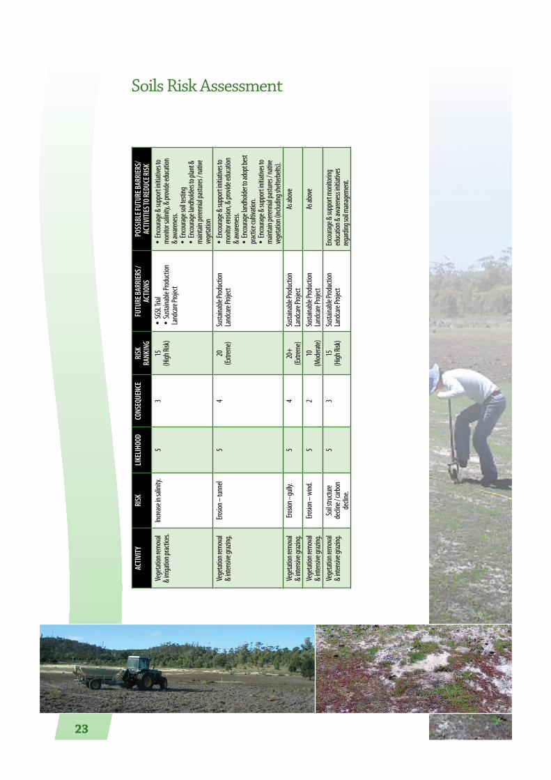
Soils Risk Assessment
Activ
ity
Risk
LikeL
ihoo
dco
nseq
uenc
eRi
sk
RAnk
ing
Futu
Re BA
RRieR
s /
Actio
nsPo
ssiB
Le Fu
tuRe
BARR
ieRs/
Activ
ities
to Re
duce
Risk
Vege
tation
remo
val
& irri
gatio
n prac
tices.
Increa
se in
salin
ity.
53
15(H
igh Ri
sk)•
SGSL
Trial
•Su
staina
ble Pr
oduc
tion
Land
care
Projec
t
•En
coura
ge &
supp
ort in
itiativ
es to
mo
nitor
salin
ity, &
prov
ide ed
ucati
on
& awa
renes
s.•
Enco
urage
soil t
estin
g•
Enco
urage
land
holde
rs to
plant
&
maint
ain pe
rennia
l pas
tures
/ nati
ve
vege
tation
Vege
tation
remo
val
& inte
nsive
graz
ing.
Erosio
n – tu
nnel
54
20(Ex
treme
)Su
staina
ble Pr
oduc
tion
Land
care
Projec
t•
Enco
urage
& su
ppor
t initia
tives
to
monit
or ero
sion,
& prov
ide ed
ucati
on
& awa
renes
s.•
Enco
urage
land
holde
r to ad
opt b
est
practi
ce cu
ltivati
on.
•En
coura
ge &
supp
ort in
itiativ
es to
ma
intain
peren
nial p
astu
res / n
ative
ve
getat
ion (in
cludin
g she
lterbe
lts).
Vege
tation
remo
val
& inte
nsive
graz
ing.
Erosio
n –gu
lly.
54
20+
(Extre
me)
Susta
inable
Prod
uctio
n La
ndca
re Pro
ject
As ab
ove
Vege
tation
remo
val
& inte
nsive
graz
ing.
Erosio
n – w
ind.
52
10(M
odera
te)Su
staina
ble Pr
oduc
tion
Land
care
Projec
tAs
abov
e
Vege
tation
remo
val
& inte
nsive
graz
ing.
Soil s
tructu
re de
cline
/ carb
on
decli
ne.
53
15(H
igh Ri
sk)Su
staina
ble Pr
oduc
tion
Land
care
Projec
tEn
coura
ge &
supp
ort m
onito
ring
educ
ation
& aw
arene
ss ini
tiativ
es
regard
ing so
il man
agem
ent.

24
Recommended Actions
o Support the continuation of the NLP / Serve Ag ‘Sustainable Agriculture’ project.
o Investigate options to progress the Sustainable Grazing on Saline Lands trial in the lower catchment.
o Encourage and support monitoring, education and awareness initiatives regarding soil management.
o Encourage and support initiatives that further define soil type and capability throughout the catchment.

25
Fire management
As a result of the low average rainfall received across this catchment, the vast majority of the catchment is essentially a dry sclerophyll*, or modified dry sclerophyll environment.
The management of fire within the environment across the catchment is essential, as fire has been present in this landscape for thousands of years.
Prior to European settlement the Aboriginal occupants of the land regularly used fire to manipulate the vegetation to improve access through the landscape and to increase opportunities for food sources.
Management of fire in today’s world is necessary for a number of reasons including, reduction of the threat and damage posed by uncontrolled wildfires, protection of structural assets and maintenance of fire dependant ecosystems.
There are a number of stakeholders which have a key role in fire management in the catchment and they include Tasmania Fire Service (TFS), Department of Defence (DofD), Forestry Tasmania (FT), Parks and Wildlife Service (PWS) and individual land owners.
The legislative responsibility of fire management lies with the TFS however it is only with community support and cooperation that fire management can be effective.
As indicated the catchment has isolated small communities and residents scattered through the area. These communities have been established in a range of vegetation types and as such have varying levels of threat from fire.
* Sclerophyll - is a type of plant that has hard stiff or leathery leaves. Dry sclerophyll forests are common in Australia and have a canopy of eucalyptus leaves.

26
The TFS promote two key approaches to fire management and the protection of assets in the rural environment.
1. To establish and maintain a DEFENDABLE SPACE around assets.
2. Broad scale REDUCTION OF FUEL LOADS in a strategic manner within suitable vegetation types. This is generally achieved by planned Low Intensity Fuel Reduction Burning.
Defendable Space
When large scale wildfires occur it is a practical impossibility for fire fighting agencies to help protect all of the homes and other assets which come under threat. It is therefore essential that all communities and residents focus on establishing a defendable space around their homes and other assets. TFS can provide guidance on how this can be achieved by way of pamphlets, DVD’s and or by requesting a visit from a local brigade officer to provide advice.
Reduction of Fuel Loads
The aim of reducing fuel loads throughout the broader environment is primarily to reduce the potential of uncontrollable wildfires which have the potential to turn into “Mega Fires”. Long term exclusion of fire from naturally dry environments have in recent years led to large scale fire events throughout Australia and other parts of the world. These wildfires result in a significant cost to society, both financially in containment costs and damage to property, and to the environment.
These impacts can be reduced by well planned and implemented Low Intensity Fuel Reduction Burns
As indicated in other sections of this plan there is a diverse range of vegetation communities across the catchment, ranging from crops and modified pastures to salt marshes , native grasslands, open woodlands and eucalypt dominated forests. Many of the native plant communities benefit and are maintained by low intensity fires.
With any use of fire, management of the frequency is critical to ensure that the floristic community structure is retained. If fires occur too frequently, species can be lost.
Fire management continued

27
Species can also be lost if fire is excluded from the environment for long periods of time. The exclusion of fire in a dry sclerophyll environment leads to a significant build up of fuel loads over time. On average dry sclerophyll forests produce approximately 2 tonnes of litter and fine fuels per hectare per year. If this litter is not reduced, over time the fuel loads increase to the point where, when fires do occur, they are uncontrollable and often cover large areas in a short time. High intensity wildfires cause significant damage to the forest environment, including fauna which lives within that environment.
Fire is a natural way to reduce fuel accumulation and by introducing controlled fires, species diversity and communities can be maintained, with the added benefit of reducing the threat to other assets from wildfires.
Planning for Low Intensity Fuel Reduction Burns must involve all the stakeholders and must be carried out in a cooperative manner at appropriate times of the year to achieve the aims set out in the plan.
Wildfires do not respect land tenure boundaries and it is in everyone interest to manage fire within the catchment in a cooperative way.
David Tucker, Glamorgan Spring Bay NRM Committee
Recommended Actions
o Initiate the development of a holistic fire management plan for the catchment involving all relevant stakeholders.
o Encourage communication between key stakeholders with fire management responsibilities.

28
Native Vegetation
The vegetation of the Little Swanport catchment is highly diverse in structure and species composition, this variation being the result of substantial variation in climate, soils, topography and disturbance history. Many rare or threatened plant species and communities are found in the catchment, especially in the drier areas and in the vegetation beside the major streams.
There are several small areas of rainforest of two types, these being situated in deep south-facing valleys in the hills. The more conventional rainforest is dominated by sassafras (Atherosperma moschatum) and musk (Olearia argophylla). This occurs in the wettest of places at relatively high altitude. In drier, fire-protected deep valleys a form of ‘dry’ rainforest, dominated by species such as native olive (Notelaea ligustrina), native pear (Pomaderris apetala), pinkwood (Beyeria viscosa) and kurrajong (Asterotrichion discolor) can be found. This community is regarded as rare on a Statewide basis.
Wet eucalypt forests, usually dominated by one of gum-topped stringybark (Eucalyptus delegatensis), stringybark (E. obliqua) or Brookers gum (E. brookerana) and with understories of broad-leaved small trees including those that dominate dry rainforest occur on the more productive sites in the higher elevations of the catchment. However, the dry eucalypt forests dominate
Broad Vegetation CommunitiesLittle Swanport River CatchmentLegend
TASVEG 1_3 Broad CommunitiesVEGCODE
Agricultural, Urban and Exotic Vegetation
Dry Eucalypt Forest and Woodland
Highland Treeless Vegetation
Moorland, Sedgeland, Rushland and Peatland
Native Grassland
Non-Eucalypt Forest and Woodland
Rainforest and Related Scrub
Saltmarsh and Wetland
Scrub, Heathland and Coastal Complexes
Wet Eucalypt Forest and Woodland
Water/Sea
Rock
Sand/Mud
Inglewood
Woodsdale
Swanston
Stonehouse
Lemont
Ravensdale
Little Swanport
May�eld
0 5 10 15
Kilometres
Base image by TASMAP, © State of Tasmania

29
most of the remaining natural area of the catchment. These have an amazing diversity of understorey types, ranging from pastel blue tussock grasslands to dense thickets of prickly shrubs, and a wide variety of mixture of eucalypts, some of which are the white peppermint (Eucalyptus pulchella), the black peppermint (Eucalyptus amygdalina), the silver peppermint (E. tenuiramis), the black gum (E. ovata), the blue gum (E. globulus) and the white gum (E. viminalis).
Woodland, scrub and forest dominated by non-eucalypts area also scattered through the catchment. Dominant species include the Oyster Bay pine (Callitris rhomboidea), the she-oak (Allocasuarina verticillata) and the lemon bottlebrush (Callistemon pallidus).
The Little Swanport River has outstanding riparian heath and scrub, some of it containing the threatened conifer, the South Esk pine (Callitris oblonga), and most of it dominated by narrow-leaved wattle (Acacia mucronata) and woolly ti-tree (Leptospermum lanigerum). Inland heaths also occur on poorly-drained, relatively infertile flats among the forests of the Eastern Tiers.
Saltmarshes are found in the Little Swanport estuary, including extensive areas of shrub samphire (Sclerostegia arbuscula). Some native grasslands dominated by kangaroo grass (Themeda triandra) or tussock grass (Poa labillardierei) have survived on the runs of grazing properties. These are threatened with imminent extinction, although not officially so.
Land clearance and clear felling of forests has taken place in the catchment over the last three decades, much of it concentrated in plant communities that are not only threatened in themselves but also contain many rare or threatened species. However, many people in the community of the catchment have taken action to preserve much of its outstanding native vegetation for the future, with some of the most valuable private reserves in Tasmania being found there.
Professor Jamie Kirkpatrick, University of Tasmania
Callitris oblonga ssp. oblonga. Courtesy of A. Zacharek.

30
Activ
ity
Risk
LikeL
ihoo
dco
nseq
uenc
eRi
sk
RAnk
ing
Futu
Re BA
RRieR
s / Ac
tions
Poss
iBLe
Futu
Re BA
RRieR
s/Ac
tiviti
es to
Redu
ce Ri
skEx
treme
fire e
vent
Loss
of ve
getat
ion. M
ay re
sult i
n po
tentia
l eros
ion &
weed
inva
sion
issue
s as w
ell as
impa
ct on
threa
tened
sp
ecies
& ve
getat
ion co
mmun
ities.
Broa
der ri
sks in
clude
impa
cts on
str
uctu
res, h
omes
& bu
sines
ses.
44
16(H
igh Ri
sk)Fir
e man
agem
ent p
lannin
g und
ertak
en by
the D
ept.
of De
fence.
•De
velop
ment
of a
holist
ic fire
mana
geme
nt pl
an fo
r the
catch
ment
in co
nsult
ation
with
relev
ant s
takeh
olders
.•
Coord
inatio
n of e
xistin
g / fu
ture
fire m
anag
emen
t pla
ns.
Weed
inva
sion
Loss
of bio
divers
ity &
struc
tural
int
egrit
y in r
emna
nt ve
getat
ion.
63
18(H
igh Ri
sk)•
GSB &
SM W
eed M
anag
emen
t Plan
s•
Priva
te lan
dhold
er eff
orts,
in w
eed c
ontro
l•
Weed
cont
rol ac
tivitie
s via
NRM
funde
d proj
ects
focus
ing on
prior
ity w
eeds
such
as Pa
tterso
n’s Cu
rse &
Sp
anish
Heath
.
Refer
to W
eed M
anag
emen
t Sec
tion
Land
cleari
ngLo
ss of
nativ
e veg
etatio
n whic
h ma
y inc
lude t
hreate
ned v
egeta
tion
comm
unitie
s & ha
ve po
tentia
l impa
cts
on th
reaten
ed flo
ra & f
auna
.
43
12(M
odera
te Ris
k)
•Fo
rest P
ractic
es Co
de•
Relev
ant le
gislat
ion su
ch as
the N
ative
Cons
ervati
on
Act.
Comm
unica
tion o
f requ
ireme
nts u
nder
the r
eleva
nt
legisla
tion.
Graz
ing pr
essu
re on
rem
nant
vege
tation
Loss
of int
egrit
y & re
silien
ce. M
ay
exac
erbate
dieb
ack &
limit c
hanc
e for
rev
egeta
tion.
53
15(H
igh Ri
sk)Fu
nding
ince
ntive
s pas
t & pr
esen
t con
tinue
to slo
wly
increa
se th
e amo
unt o
f remn
ant v
egeta
tion m
anag
ed
throu
gh fe
ncing
.
•On
going
supp
ort o
f land
holde
rs in
acce
ssing
avail
able
fundin
g.•
Ongo
ing co
mmun
icatio
n of th
e suc
cess
of su
ch
initia
tives
to th
e broa
der c
atchm
ent c
ommu
nity.
Sprea
d of ro
ot rot
fun
gus P
hytop
htho
ra cin
namo
mi th
rough
ve
hicle
& walk
ing
traffi
c.
Die ba
ck in
vulne
rable
comm
unitie
s su
ch as
heath
lands
.3
515
(High
Risk)
Fores
t Prac
tices
Code
•Fin
d out
if an
d whe
re Ph
ytoph
thora
occu
rs in
the
catch
ment.
•De
termi
ne ex
tent o
f vuln
erable
vege
tation
co
mmun
ities.
•De
velop
man
agem
ent p
lan to
prote
ct pri
ority
areas
fro
m fut
ure in
vasio
n.Cle
aring
over
time
result
ing in
isolat
ed
remna
nts.
Remn
ants
susce
ptibl
e to e
dge e
ffects
, su
ch as
wee
d inv
asion
& ex
posu
re to
wind
, whic
h ove
r time
redu
ces
resilie
nce w
hich m
ay re
sult i
n los
s of
integ
rity &
dieb
ack.
64
24(Ex
treme
Risk)
•So
uthe
rn M
idlan
ds Bu
shca
re Str
ategy
has id
entifi
ed
the l
ocati
ons o
f remn
ants
& rec
omme
nds a
‘corri
dor’
conc
ept to
link s
trateg
ic area
s.•
Past
& curr
ent fe
ncing
& rev
egeta
tion i
nitiat
ives in
th
e Sou
thern
Midl
ands
refer
to th
is stra
tegy.
•Ex
tend t
his ‘co
rrido
r’ stra
tegy t
o the
GSB e
nd of
the
catch
ment.
•Co
ntinu
e to s
eek f
undin
g to p
rogres
s an s
trateg
ic ap
proac
h to r
eveg
etatio
n & re
mnan
t prot
ectio
n.
Nativ
e gras
sland
s ma
nage
ment.
Overg
razing
or gr
azing
at th
e wron
g tim
e may
resu
lt in w
eed i
nvas
ion &
los
s of s
pecie
s dive
rsity
& com
munit
y int
egrit
y.
44
16(H
igh Ri
sk)Su
ppor
t for m
anag
ing re
mnan
t veg
etatio
n inc
luding
gra
sslan
ds ha
s bee
n ava
ilable
.•
Cont
inue t
o link
inter
ested
land
holde
rs wi
th th
e ap
propri
ate pr
ogram
s & th
e rele
vant
infor
matio
n.
Mana
geme
nt of
rem
nant
vege
tation
co
mmun
ities.
May r
esult
in re
ducti
on in
biod
iversi
ty & s
tructu
ral in
tegrit
y perh
aps t
hroug
h we
ed in
vasio
n, us
e of in
appro
priate
fir
e reg
imes,
or fir
ewoo
d coll
ectio
n (p
ermitt
ed or
illeg
al)
44
16(H
igh Ri
sk)•
Past
& curr
ent v
egeta
tion c
onse
rvatio
n prog
rams
offer
landh
olders
advic
e & su
ppor
t for m
anag
ing
remna
nt ve
getat
ion.
•Th
e ‘Man
aging
Your
Bush
’ publi
catio
n is a
n exce
llent
gu
ide to
assis
t land
holde
rs.
•Co
ntinu
e to l
ink in
teres
ted la
ndho
lders
with
the
appro
priate
prog
rams, r
eleva
nt re
feren
ces &
avail
able
resou
rces t
o assi
st in
impro
ving m
anag
emen
t tech
nique
s.•
Enco
urage
parti
cipati
on in
the ‘B
ushw
atch’ p
rogram
to
curb
illega
l firew
ood c
ollec
tion a
ctivit
ies.
Land
scape
s &
areas
suffe
ring t
ree
decli
ne re
quirin
g rev
egeta
tion.
Increa
ses in
tree d
iebac
k, & s
oil lo
ss du
e to
lack o
f veg
etatio
n cov
er.6
424
(Extre
me Ri
sk)•
Sout
hern
Midl
ands
Bush
care
Strate
gy ha
s iden
tified
th
e loc
ation
s of re
mnan
ts & r
ecom
mend
s a ‘co
rrido
r’ co
ncep
t to lin
k stra
tegic a
reas.
•Va
rious
Land
care
initia
tives
have
been
triall
ed to
re-
estab
lish ve
getat
ion co
ver in
erod
ed ar
eas e
g.
•Ex
tend t
his ‘co
rrido
r’ stra
tegy t
o the
GSB e
nd of
the
catch
ment
& se
ek fu
nding
to en
able
strate
gic fe
ncing
&
reveg
etatio
n..•
Cont
inue t
o see
k fun
ding t
o assi
st lan
dhold
ers in
rev
egeta
ting e
roded
land
scape
s.
Native Vegetation Risk Assessment

31
Recommended Actions
o Initiate the development of a holistic fire management plan for the catchment involving all relevant stakeholders.
o Communicate current native vegetation legislation to landholders eg. via catchment newsletter.
o Support landholders with managing native vegetation through:
- facilitating access to funding;
- provide information;
- linking to available programs and organisations.
o Find out the existence and distribution of Phythophthora cinnamomi in the catchment.
o Support strategic vegetation management initiatives to maintain and connect remnant vegetation in the landscape eg. Southern Midlands Bushcare Strategy.
o Raise awareness of the ‘Bushwatch’ program to encourage reporting of illegal firewood collection.

32
Weeds
Weeds are among the most serious threats to primary production and the natural environment in the Little Swanport Catchment. They reduce farm and forest productivity, displace and degrade native species and communities, and contribute significantly to land and water degradation. The effects of weeds may be direct, such as:
othe loss of agricultural production as a result of weed competition with crops;
othe loss of conservation values when native bushland is replaced by weeds;
othe time and money spent on removing weeds from paddocks and gardens. Or indirect, for example:
othe higher price of food due to increased production costs caused by weeds;
and
• oncreased severity of bushfires due to flammable weeds.
In the Little Swanport Catchment many of our current weed problems come from plants that were deliberately introduced to the area for a variety of reasons. A classic example is gorse which was planted for hedgerows and stock fodder in early settlement days.
Our future weeds may be some of the plants that we are currently planting in our gardens which may become ‘garden escapees’. An example of this is Agapanthus which is a popular hardy garden plant which has the potential to spread in bush areas. There are concerns that the introduction of the Bumble Bee into Tasmania is increasing the viability of Agapanthus seed and may result in increased weedy potential in the future.
The Little Swanport Catchment has many challenges with weed management due to a diverse population with different understandings of what the issues are and different capacities to manage existing and emerging problem weeds.
The Glamorgan Spring Bay and Southern Midlands Council’s have both developed Weed Management Plans that provide a strategic approach to addressing these complex issues.

33
These weed management plans identify a variety of ways to improve weed management especially through the pooling of resources and knowledge by all land managers. They recognize that communication is a key element of successful weed management as often land managers and the general community are not aware of significant weed threats and what to do about them.
These plans have assisted the Council’s to obtain funding and work with public and private land managers to control priority weeds.
Throughout Tasmania Declared weeds under the Tasmanian Weed Management Act 1999 are prioritised for management according to zones.
ZONE A – Declared weeds are highest priority. The aim is to eradicate these weeds which have a huge potential to spread and become very costly to control, but are currently in low numbers. Examples include:
ZONE B – These weeds are already widespread and the aim is to contain their spread. An example of this is gorse, and both Councils have a roadside control program in place.
Helen Geard & Mel Kelly, NRM Officers, Southern Midlands and Glamorgan Spring Bay Council
Serrated Tussock (Nassella trichotoma) Spanish Heath (Erica lusitanica)
Gorse (Ulex europaeus)
Weeds continued

34
Weed Risk Assessment
Activ
ity
Risk
LikeL
ihoo
dco
nseq
uenc
eRi
sk RA
nkin
gFu
tuRe
BARR
ieRs /
Actio
nsPo
ssiB
Le Fu
tuRe
BARR
ieRs/
Activ
ities
to Re
duce
Risk
Unco
ordina
ted &
ad ho
c we
ed co
ntrol
activ
ities.
Misu
se of
limite
d wee
d ma
nage
ment
reso
urces
du
e to i
napp
ropria
te pri
oritis
ing of
cont
rol
activ
ities.
54
20(Ex
treme
)•
Weed
map
ping u
ndert
aken
by Co
uncil
NRM
office
rs as
part
of im
pleme
nting
WMP
s.•
SM Co
uncil
road
side g
orse c
ontro
l prog
ram in
partn
ership
wi
th ad
joinin
g lan
dhold
ers. G
SB ro
adsid
e spra
ying p
rogram
.•
GSB N
RMC r
eview
of W
MP &
resou
rces f
or im
pleme
ntati
on.
•Bu
ild up
on an
d rev
iew ex
isting
map
ping b
ased
on cu
rrent
un
derst
andin
g of p
riorit
y wee
ds.
•Wo
rk in
partn
ership
with
both
Coun
cil’s &
DPIPW
E to e
nsure
an
y wee
d map
ping i
nform
ation
is inc
luded
into
any e
xistin
g da
tabas
es of
wee
d info
rmati
on.
Use o
f plan
ts in
garde
ns
with
wee
d pote
ntial
.Inc
rease
sprea
d of
poten
tially
inva
sive
plant
s.
44
16(H
igh Ri
sk)•
Many
years
of in
forma
tion v
ia on
going
Coun
cil ne
wslet
ters
& thro
ugh i
nform
ation
broc
hures
on ‘en
viron
ment
al we
eds’.
•De
velop
ment
of th
e GSB
‘Grow
Loca
l’ pos
ter w
hich g
ives
inform
ation
on su
itable
alter
nativ
e nati
ve pl
ants.
•Wo
rk wi
th re
levan
t orga
nisati
ons in
deve
loping
&
distri
butin
g targ
eted i
nform
ation
on en
viron
ment
al we
eds &
su
itable
repla
ceme
nt pl
ants.
•De
velop
a de
mons
tratio
n nati
ve pl
ant g
arden
at th
e ‘Ra
vens
dale
Hall’ i
n the
lowe
r catc
hmen
t & at
Woo
dsda
le in
the
midd
le ca
tchme
nt.
Accid
ental
sprea
d of
weed
s due
to la
ck of
aw
arene
ss.
Increa
se sp
read o
f po
tentia
lly in
vasiv
e pla
nts.
44
16(H
igh Ri
sk)•
Many
years
of in
forma
tion v
ia Co
uncil
news
letter
s & th
rough
inf
ormati
on br
ochu
res on
wee
ds.
•Inc
rease
d und
erstan
ding o
f the t
ypes,
loca
tions
& pri
ority
of we
eds t
hroug
hout
the c
atchm
ent (&
the a
ssets
that
they
may
th
reaten
) as a
resu
lt of th
e dev
elopm
ent o
f the t
wo Co
uncil
We
ed M
anag
emen
t Plan
s as w
ell as
impro
ved k
nowl
edge
of
weed
s in ge
neral
.•
Deve
lopme
nt of
the D
PIPW
EE ‘W
ashd
own G
uideli
nes’.
•NR
M So
uth f
unde
d proj
ect o
n wee
d hyg
iene f
or loc
al go
vern
ment,
Hydro
, PW
S & co
ntrac
tors.
•Co
ntinu
e to w
ork w
ith re
levan
t orga
nisati
ons in
deve
loping
& d
istrib
uting
infor
matio
n on p
riorit
y wee
ds in
the c
atchm
ent
& bes
t prac
tice t
o prev
ent s
pread
& pro
tect p
riorit
y asse
ts.•
Supp
ort e
duca
tion a
nd tra
ining
initia
tives
that
enco
urage
be
st pra
ctice
to av
oid w
eed s
pread
. eg.
vehic
le hy
giene
.
Accid
ental
sprea
d of
weed
s due
to po
or
equip
ment
hygie
ne.
Increa
se sp
read o
f po
tentia
lly in
vasiv
e pla
nts.
44
16(H
igh Ri
sk)•
Curre
nt NR
M So
uth f
unde
d proj
ect o
n wee
d hyg
iene f
or loc
al go
vern
ment,
Hydro
, PW
S & co
ntrac
tors.
•Pa
rticip
ate in
prog
rams &
proje
cts th
at foc
us on
best
practi
ce hy
giene
prac
tices
to pr
even
t wee
d spre
ad.
•Or
ganis
e a Be
st Pra
ctice
Wee
d Man
agem
ent D
emon
strati
on
day t
hat in
corpo
rates
infor
matio
n on w
eed h
ygien
e prot
ocols
.Sp
read o
f wee
ds du
e to
lack o
f time
& res
ource
s.Inc
rease
sprea
d of
poten
tially
inva
sive
plant
s.
44
16(H
igh Ri
sk)•
Durin
g NHT
1 sig
nifica
nt fu
nding
was
avail
able
for st
rateg
ic on
grou
nd w
ork fo
r wee
d con
trol.
•We
ed m
anag
emen
t plan
s hav
e bee
n dev
elope
d in b
oth
Coun
cil ar
eas w
hich h
ave r
esult
ed in
addit
ional
resou
rces
•Co
ntinu
e to w
ork in
partn
ership
with
NRM
Office
rs & N
RM
Sout
h to a
ccess
fundin
g for
cont
rol of
prior
ity w
eeds
.
Sprea
d of w
eeds
due
to lac
k of k
nowl
edge
of
how
to co
ntrol
.
Increa
se sp
read o
f po
tentia
lly in
vasiv
e pla
nts.
44
16(H
igh Ri
sk)•
Over
the l
ast te
n yea
rs th
ere ha
s bee
n an i
ncrea
se in
kn
owled
ge of
best
practi
ce co
ntrol
mea
sures
of pr
iority
wee
ds
such
as go
rse.
•Or
ganis
e a Be
st Pra
ctice
Wee
d Man
agem
ent D
emon
strati
on
day f
ocus
ing on
cont
rol of
prior
ity w
eeds
.•
Work
with
relev
ant o
rganis
ation
s in de
velop
ing &
dis
tribu
ting b
est p
ractic
e con
trol in
forma
tion.
Impo
rtatio
n of
cont
amina
ted gr
ain &
an
imal
feed.
Increa
se sp
read o
f po
tentia
lly in
vasiv
e pla
nts.
44
16(H
igh Ri
sk)•
Quara
ntine
mea
sures
exist
but u
nsure
of w
hat th
ey ar
e &
how
effec
tive t
hey a
re.•
Prope
rty M
anag
emen
t Plan
ning p
roces
s look
s at h
ow to
ad
dress
farm
scale
issue
s suc
h as d
ealin
g with
cont
amina
ted
grain
& anim
al fee
d.
•Ne
ed to
find o
ut w
hat Q
uaran
tine m
easu
res ar
e in p
lace &
ho
w eff
ectiv
e the
y are.
•En
coura
ge la
ndho
lders
to pu
t in pl
ace s
trateg
ies to
im
media
tely c
ontro
l & pr
even
t the s
pread
of an
y wee
ds w
hich
may a
rrive
throu
gh co
ntam
inated
grain
, anim
al fee
d or s
oil.

35
NB: All actions to link in with the Glamorgan Spring Bay and Southern Midlands Weed Management Plans.
o Encourage and support NRM regional and local / state government initiatives to digitise existing weed mapping data and review weed maps with landholders.
o Encourage and support further mapping as required.
o Work in partnership with NRM regional and local / state government initiatives in communication and education initiatives eg. field days
o Support landholders with managing weeds through:
- development of property based weed action plans;
- facilitating access to funding;
- access to relevant information;
- linking to available programs and organisations.
Recommended Actions

36
Estuary/Coastal Marine
At the bottom of the catchment the Little Swanport River flows into Great Oyster Bay via the estuary.
The estuary sits approximately 60km downstream from the headwaters. Two other smaller rivers in the catchment, the Buxton River and the Lisdillon Rivulet, also flow directly into the Bay through smaller estuaries. The Little Swanport estuary, approximately 8km in length, is a relatively unimpacted estuary, with no surrounding towns, and is highly valued for its natural beauty and recreational opportunities.
The estuary is classified as wave dominated or bar built. A barrier at the mouth restricts water exchange with Great Oyster Bay to a narrow channel and encloses a large central basin. The estuary is predominately marine influenced during normal river flows but is freshwater dominated during flooding of the Little Swanport River. The head of the estuary is typical of this type of system with shallow mudflats flanked by salt marsh wetlands. These form from the deposition of land-based sediments at the entrance of the river to the estuary. The tidal influence extends to several km above the bridge.
The estuary is a highly dynamic and productive system. It contains extensive seagrass beds which provide shelter and food for a wide diversity of animal life. Forty three species of fish have been recorded from the estuary. Most are transitory marine species that occupy the estuary during part of their life cycle. A few species spend their entire life in the estuary. For example black bream are the most abundant fish in the estuary and a popular target fish for recreational fishers. There are also several migratory species that move between freshwater and the ocean, including eels, whitebait and the Australian grayling.
Aquaculture is an important commercial activity in the estuary with 60 hectares leased for Pacific oyster farming. The oysters are grown on racks installed in the lower intertidal area. An oyster nursery which supplies approximately 70% of the oyster juveniles (spat) to marine farms in Tasmania and South Australia is also located on the banks of the estuary and uses the estuarine water to grow the spat.
Although the estuary and coastal waters are relatively unaffected by human activities, there are still issues of concern. Lack of freshwater flow into the

37
estuary, whether naturally due to changing climatic conditions resulting in lower rainfall or increasing demand for irrigation, changes the estuary to a more marine dominated system. There is some concern that the lower freshwater flows are reducing the nutrient input into the estuary, especially nitrogen and silicates, which are important to the production of the microalgal food of oysters. On the other hand, large floods transport high loads of nutrients and sediment from the land into the estuary and coastal waters, which can lead to the production of nuisance algal blooms and altered habitat. Changing climatic conditions are likely to affect the estuary and coastal systems. Lower rainfall and stronger influence of the nutrient poor East Australian Current may produce some changes in the species that occur in the estuary and coastal waters and a reduction in productivity. Already we are seeing massive algal blooms, never seen before, in local waters.
Dr Christine Crawford Program Leader - Marine Environment Tasmanian Aquaculture and Fisheries Institute

38
Activ
ity
Risk
LikeL
ihoo
dco
nseq
uenc
eRi
sk RA
nkin
gFu
tuRe
BARR
ieRs /
Actio
nsPo
ssiB
Le Fu
tuRe
BARR
ieRs/
Activ
ities
to
Redu
ce Ri
skInc
rease
s in co
astal
de
velop
ment.
Poten
tial to
impa
ct on
signifi
cant
co
astal
value
s eg.
Resid
entia
l de
velop
ment
adjac
ent to
beac
hes
which
are s
ignific
ant s
horeb
ird
breed
ing sit
es.
63
18(H
igh Ri
sk)•
GSBC
Plan
ning S
chem
e•
State
Coas
tal Po
licy
•Co
astal
Value
s Data
base
•Pa
rks &
Wildl
ife Se
rvice
Rang
ers•
NRM
/ PW
S init
iative
s suc
h as in
volvi
ng
landh
olders
in go
rse re
mova
l proj
ects
along
the
fores
hore.
•Pro
activ
e com
munic
ation
to ne
w res
ident
s and
deve
lopers
of th
e sign
ifican
t co
astal
value
s in th
e catc
hmen
t eg.
Deve
lopme
nt of
a bo
oklet
simila
r to ‘Li
ving
at Nin
e Mile
Beac
h’ dev
elope
d by C
oastc
are
for re
siden
ts at
Dolph
in Sa
nds.
•Cre
ate op
portu
nities
for in
volve
ment
in
activ
ities s
uch a
s wee
ding &
reve
getat
ion,
which
prote
ct an
d imp
rove c
oasta
l valu
es.Lim
ited k
nowl
edge
or
unde
rstan
ding o
f rel
evan
t legis
lation
, co
des o
f prac
tice,
plann
ing sc
heme
s etc.
Comm
unity
confl
ict &
possi
ble
mism
anag
emen
t, law
s bein
g bro
ken &
fines
/litiga
tion.
53
13(H
igh Ri
sk)•
Prope
rty ow
ners
are in
forme
d by C
ounc
il ab
out c
ertain
param
eters
as de
fined
in th
e Pla
nning
Sche
me up
on un
derta
king a
ny
deve
lopme
nt.•
Signa
ge in
certa
in loc
ation
s instr
uctin
g wha
t is
& is n
ot all
owed
.•
Word
of mo
uth w
ith re
gard
to wh
at is &
is no
t ac
cept
able.
•Inc
rease
d ava
ilabil
ity &
usag
e of th
e inte
rnet
which
enab
les ac
cess
& com
munic
ation
of ru
les
& guid
eline
s.
•En
sure
that
inform
ation
on w
hat
legisla
tion e
tc of
relev
ance
to th
e area
is inc
luded
in th
e ‘Livi
ng at
Saltw
orks &
Ponty
Po
ol’ b
ookle
t. En
sure
clear
detai
ls on
where
to go
shou
ld yo
u be u
nsure
of w
hat
is acce
ptab
le is a
lso co
mmun
icated
to al
l res
ident
s.
Fishin
g for
bream
at
the m
outh
of th
e Litt
le Sw
anpo
rt Riv
er
Possi
bility
of ov
erfish
ing
espe
cially
durin
g the
spaw
ning
seas
on w
hich c
ould
have
a se
rious
im
pact
in th
e num
bers
of bre
am
into t
he fu
ture.
44
16(H
igh Ri
sk)•
A PhD
rese
arch p
rojec
t on t
he bi
ology
, hab
its &
mo
veme
nts o
f the B
lack B
ream
in th
e estu
ary.
•Co
mmun
icate
the o
utcom
es of
rese
arch
to th
e nec
essa
ry ma
nage
ment
agen
cies &
th
e fish
ing co
mmun
ity.
•Wo
rk wi
th th
e app
ropria
te ma
nage
ment
ag
encie
s & th
e rec
reatio
nal fi
shing
lobb
y to
deve
lop m
anag
emen
t acti
ons t
o prot
ect th
is an
d oth
er fis
h spe
cies in
to th
e fut
ure.
Acce
ss of
stock
to
saltm
arsh a
long t
he
estu
ary.
Impa
cts on
saltm
arsh i
ntegri
ty th
rough
graz
ing, tr
ampli
ng &
nit
rifica
tion.
Faec
al co
ntam
inatio
n whic
h may
im
pact
on w
ater q
uality
.
63
18(H
igh Ri
sk)•
Previo
us La
ndca
re fun
ding h
as re
sulte
d in
secti
ons b
eing f
ence
d from
stoc
k.•
Curre
nt NR
M inc
entiv
es pr
ogram
is lik
ely to
res
ult in
more
land
holde
rs fen
cing o
ff salt
marsh
.•
CEFV
datab
ase h
as in
creas
ed kn
owled
ge of
sa
ltmars
h loc
ation
s & qu
ality
& this
infor
matio
n wi
ll be a
vaila
ble fo
r land
holde
rs inv
olved
in
Prope
rty M
anag
emen
t Plan
ning.
•Ca
tchme
nt Co
ordina
tor po
sition
has b
een
invalu
able
in co
mmun
icatin
g valu
e of s
altma
rsh
& assi
sting
in lin
king l
andh
olders
to fu
nding
op
portu
nities
.
•Wo
rk wi
th NR
M So
uth i
n dev
elopin
g sim
ple in
forma
tion o
n the
value
of
saltm
arsh i
n the
estu
ary.
•En
sure
the C
atchm
ent C
oordi
nator
co
ntinu
es to
enab
le lan
dhold
ers to
get
assis
tance
in so
urcing
fund
ing fo
r fenc
ing to
pro
tect th
e salt
marsh
from
grazin
g pres
sure.
Estuary/Coastal Marine Risk Assessment

39
o Support the development of a ‘Living At …….’ booklet that covers the coastal communities of Pontypool and Saltworks, as well as others living around the estuary.
o Continue to keep abreast of research of estuarine, coastal and marine research and use catchment meetings as an opportunity for information exchange.
o Continue to use the Catchmant to Coasts newsletter as a means to communicate to the broader community information about estuary, coastal and marine issues, values and activities.
Recommended Actions
Courtesy of Maurice Banks Collection

40
Threatened Species
The Little Swanport River Catchment supports a diversity of habitats for native fauna reflecting the high diversity of vegetation types and pant communities present. Most of the native vegetation remaining in the catchment is dominated by dry eucalypt forest types with other well represented habitats including riparian heaths and scrubs, and extensive saltmarshes in the Little Swanport estuary.
The Little Swanport catchment supports important habitat for several threatened fauna species with a widespread distribution in Tasmania. The population of Tasmanian devils (Sacophilus harrisii) in the catchment is currently low, though they are still apparent, particularly younger animals dispersing at the end of summer. This area is noteworthy for the presence of occasional devils with pale grey fur. The density of Spotted-tailed quolls (Dasyurus maculatus maculatus) is low though they occur throughout the catchment with some records close to the coast. The catchment supports a high density of Wedge-tailed eagles (Aquila audax fleayi), and White-bellied sea eagles (Haliaeetus leucogaster) are common along the coastline. The Tasmanian Masked owl (Tyto novaehollandiae castanops) is common in the lower catchment and near coastal areas with several records of nesting. Swift Parrots (Lathamus discolour) occur in the breeding season between September and February in near coastal areas where they rely primarily on forests supporting blue gum for food, and old forests supporting hollows for nesting.
Few threatened invertebrates have been recorded in the Little Swanport catchment except for Chaostola skipper (Antipodia chaostola). Chaostola skipper is a small butterfly with only a few isolated colonies known along the east coast. The foodplant of the caterpillar is the thatch sawsedge (Gahnia radula) which is found on sandstone and mudstone substrates, usually associated with black peppermint (Eucalyptus amygdalina) forest.
Additional species and new localities within the Little Swanport catchment may be revealed by further dedicated surveys for threatened species. Conservation management of potential habitat for threatened fauna is an important action for species recovery for most of the threatened fauna recorded within the catchment.

41
Little Swanport catchment is known to be home to 35–40 threatened flora species. Many of these have specific habitat and disturbance requirements. Dry eucalypt woodlands and forests on dolerite substrates, for example, may contain a strong endemic component with species such as Deyeuxia apsleyensis (apsley bentgrass), Eucalyptus barberi (barbers gum) and Ozothamnus lycopodioides (clubmoss everlasting bush). Species associated with other habitats include: grassy woodlands — Desmodium gunnii (slender ticktrefoil), Eryngium ovinum (blue devil) and Scleranthus fasciculatus (spreading knawel); riparian systems — Baumea gunnii (slender twigsedge) and Pomaderris phylicifolia (narrowleaf dogwood); rockplates — Pellaea calidirupium (hotrock fern) and Poa mollis (soft tussockgrass). Species such as Gyrostemon thesioides (broom wheelfruit) and Cyphanthera tasmanica (Tasmanian rayflower) may be locally abundant after fire, but rarely seen at other times.
Our knowledge of the distribution of threatened flora within the catchment is relatively poor, reflecting the limited survey effort to date, and it is considered highly likely that additional species will be uncovered given a targeted and well-resourced survey effort. In addition, site assessments are required to determine the status of recorded sites and the needs for specific management actions.
The Little Swanport River Catchment supports a diversity of habitats for native fauna reflecting the high diversity of vegetation types and plant communities present. Most of the native vegetation remaining in the catchment is dominated by dry eucalypt forest types with other well represented habitats including riparian heaths and scrubs, and extensive saltmarshes in the Little Swanport estuary.
The Little Swanport catchment supports important habitat for several threatened fauna species with a widespread distribution in Tasmania. The population of Tasmanian devils (Sacophilus harrisii) in the catchment is currently low, though they are still apparent, particularly younger animals dispersing at the end of summer. This area is noteworthy for the presence of occasional devils with pale grey fur. The density of Spotted-tailed quolls (Dasyurus maculatus maculatus) is low though they occur throughout the catchment with some records close to the coast. The catchment supports a high density of Wedge-tailed eagles (Aquila audax fleayi), and White-bellied sea eagles (Haliaeetus leucogaster) are common along the coastline. The Tasmanian Masked owl (Tyto novaehollandiae castanops) is common in the lower catchment and near coastal areas with several records of nesting. Swift Parrots (Lathamus discolour) occur in the breeding season between September and February in near coastal areas where they rely primarily on forests supporting blue gum for food, and old forests supporting hollows for nesting.
Narrow DogwoodPomaderris phylicifolia ssp. phylicifolia. Courtesy H & A Wapstra
Clubmoss Everlasting BushOzothamnus lycopodioides. Courtesy G. Jordan

42
Few threatened invertebrates have been recorded in the Little Swanport catchment except for Chaostola skipper (Antipodia chaostola). Chaostola skipper is a small butterfly with only a few isolated colonies known along the east coast. The foodplant of the caterpillar is the thatch sawsedge (Gahnia radula) which is found on sandstone and mudstone substrates, usually associated with black peppermint (Eucalyptus amygdalina) forest.
Additional species and new localities within the Little Swanport catchment may be revealed by further dedicated surveys for threatened species. Conservation management of potential habitat for threatened fauna is an important action for species recovery for most of the threatened fauna recorded within the catchment.
Dr Phil BellSection HeadThreatened Species SectionBiodiversity Conservation BranchDepartment of Primary Industries and Water
Recommended Actions
o Continue to provide support for land managers to protect, manage and establish remnant vegetation because it provides the best habitat for fauna;
o Encourage and support research and monitoring of threatened species in the catchment.
o Communicate information about the importance and value of threatened species in the catchment;
Tasmanian Ray Flower Cyphanthera tasmanica.
Courtesy G. Jordan
Barbers Gum Eucalyptus barberi flowers. Courtesy
M. Hanson
Threatened Species continued

43
Game Management
The Game Management Services Unit (GMSU) sits within the Department of Primary Industries, Park, Water and Environment (DPIPWE). The GMSU is dedicated to implementing sustainable management programs for a range of species including Bennett’s & Rufous Wallaby, Brushtail Possum, Fallow Deer, Wild Duck, Ringneck Pheasant & Brown Quail.
The management objectives of the above species are directed through the allocation of licensed game seasons and/or species control through the issuing of crop protection permits. Species, licences and permits are covered under the Nature Conservation Act 2002 and the Wildlife Regulations 1999, with the onus being on hunters and landowners to be familiar with this legislation.
The Little Swanport Catchment region encompasses a majority of the species managed by the GMSU. As with other regions in Tasmania, the pathway to successful game management is to find a balance between the needs of game and the needs of farmers, foresters and community.
Species in the Little Swanport Catchment such as Wild Duck and Fallow Deer are regarded as having significant recreational value. These species are actively pursued by local and visiting recreational hunters during the game season periods.
Native browsing animals such as Bennett’s & Rufous Wallaby and Brushtail Possum are in very high abundance in the catchment and are a source of direct conflict for farmers, foresters and their resources.
In unmanaged situations, Wallaby and Possum can cause high level browsing damage on agricultural and forestry resources. This impact can be proactively managed through the use of control methods such as shooting and game fencing. The way forward for landowners is to develop a damage management strategy and this may be delivered through a Property based Wildlife Management Plan (PBWMP).
The ability of landowners or managers to control Wallaby and Possum numbers at an individual property level is vital for successful browsing animal management to be achieved across the region. They are encouraged to contact the GMSU to discuss game management on their properties.
Recreational hunters can play a big role in assisting landowners to control browsing animals on their properties. In a similar way, recreational hunters can also assist in managing the game resource through sending their game harvest data forms to the GMSU.
Matt Byrne Game Management Officer , Game Management Services Unit
Recommended Action
o Inform landholders of the services of Game Management Services Unit in developing property based game management plans.

44
Aboriginal Heritage & Culture
The Oyster Bay Tribe’s territory extended from St. Patrick’s Head in the north to the Derwent River estuary in the south.
There were ten bands in the tribe of which the Pordeareme lived around Little Swanport during the winter eating shellfish and marine vegetables until July.
At the end of August the band would join the Laremairremener band from Grindstone Bay, the Portmairremener from the Prosser River and the Tyreddeme from Maria Island and move inland along the Little Swanport and Prosser Rivers to the Eastern Marshes to hunt birds, kangaroos and wallabies.
The bands would move further west with the approach of summer as far as the Clyde and Ouse Rivers and then return through the Midlands arriving back at the coast in June (Ryan, 1982).
Values and RiskThere are a range of Aboriginal values in the Little Swanport catchment.
These include a high concentration of quarry sites along the middle reaches of the Swanport River, coastal middens, and important cultural landscapes and cultural resources.
Significant Aboriginal cultural heritage places tend to aggregate around water ways, and this is particularly the case surrounding the river and waterways of the Little Swanport catchment.
Development, particularly the rapid increase in coastal development is a potential threat to Aboriginal cultural heritage sites. Intensive agriculture, grazing and hydro activities are also a potential threat.
Risk to aboriginal heritage can be minimized when management processes are undertaken in consultation with the Aboriginal community through the Tasmanian Aboriginal Land and Sea Council (TALSC).
All Aboriginal sites are protected under the Tasmanian Government’s Aboriginal Relics Act 1975.
New aboriginal Heritage Legislation is being developed that will replace this act.
The new legislation will require local government to address Aboriginal cultural heritage protection within their planning schemes.
Paul DawsonAboriginal NRM Support OfficerNRM South/Tasmanian Aboriginal Land and Sea Council
Recommended Actiono Develop a positive relationship with the Tasmanian Aboriginal Community eg. organise
a presentation on the Aboriginal Heritage of the catchment from representatives of the Tasmanian Aboriginal Land and Sea Council.

45
References and Bibliography
Little Swanport Catchment Committee. 2003. Little Swanport Catchment Management Plan. Little Swanport, Tasmania, Australia.
Little Swanport Catchment Management Plan Implementation Committee. 2008. A decade of integrated catchment management in the Little Swanport Catchment. Little Swanport, Tasmania, Australia.
Nixon Report. 1997. Tasmania into the 21st Century
Commonwealth/State inquiry into the Tasmanian Economy. Hobart, Tasmania
Ryan, L. 1982. The Aboriginal Tasmanians. University of Queensland Press, Queensland.
Seafood Services Australia. 2004. Seafood EMS Self-assessment and training manual. Seafood Services Australia Ltd, Ascot, QLD
Contact Information:
Chair, Little Swanport Catch50ment Management
Plan Implementation Committee: 6254 6153
Glamorgan Spring Bay NRM Officer, Glamorgan Spring Bay Council: 6257 4777 www.gsbc.tas.gov.au
Southern Midlands NRM Officer, Southern Midlands Council: 6256 5046 www.southernmidlands.tas.gov.au
NRM South: 6221 6111 www.nrmsouth.org.au

GLAMORGAN SPRING BAYCOUNCIL
Glamorgan Spring BayNatural Resource Management