Embed Size (px)
Citation preview
Working with Elevation Data Using Mosaic Datasets & Image Services
Peter Becker
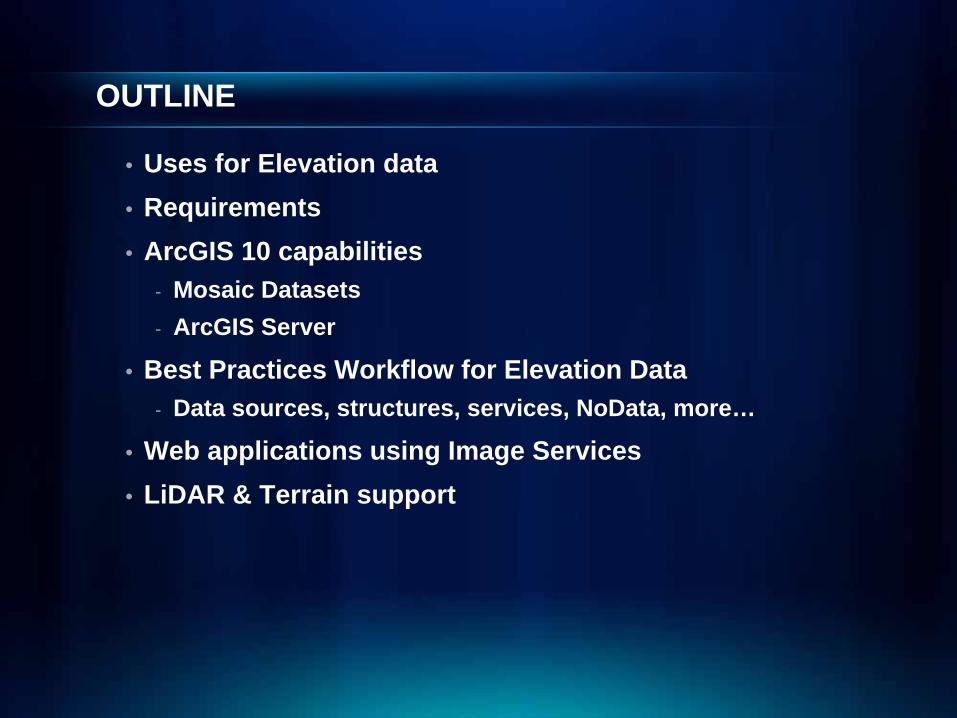
OUTLINE
• Uses for Elevation data• Requirements• ArcGIS 10 capabilities
- Mosaic Datasets- ArcGIS Server
• Best Practices Workflow for Elevation Data- Data sources, structures, services, NoData, more…
• Web applications using Image Services• LiDAR & Terrain support
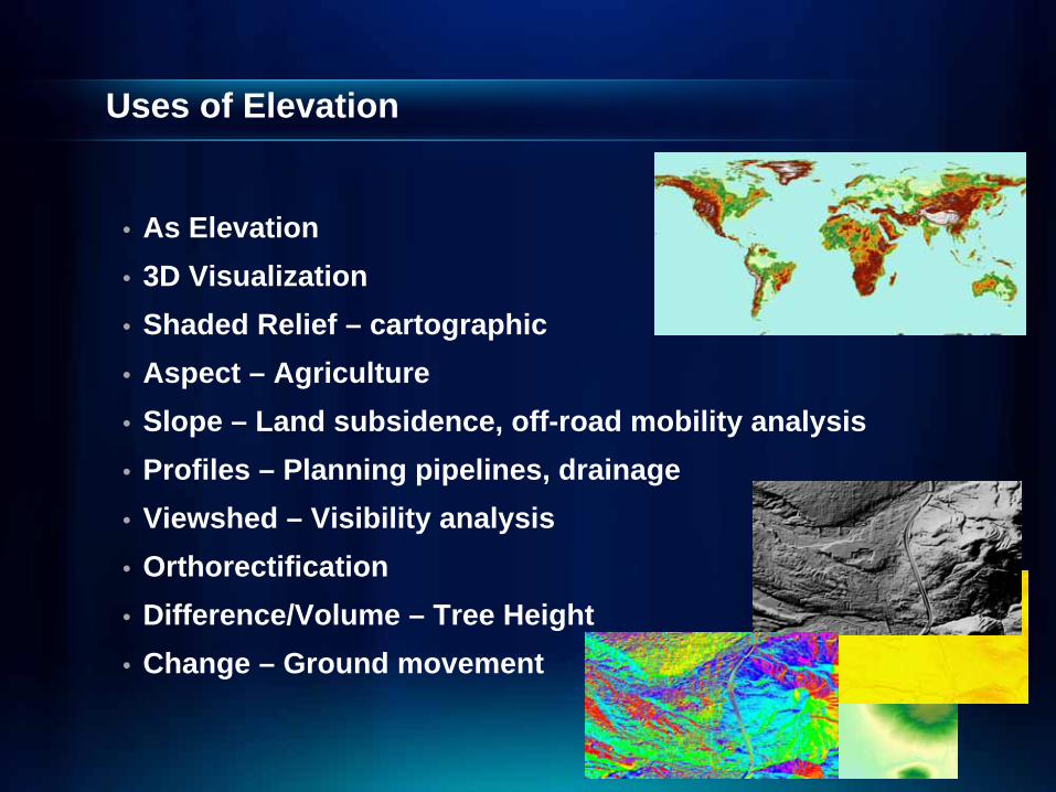
Uses of Elevation
• As Elevation• 3D Visualization• Shaded Relief – cartographic • Aspect – Agriculture • Slope – Land subsidence, off-road mobility analysis • Profiles – Planning pipelines, drainage• Viewshed – Visibility analysis• Orthorectification• Difference/Volume – Tree Height• Change – Ground movement
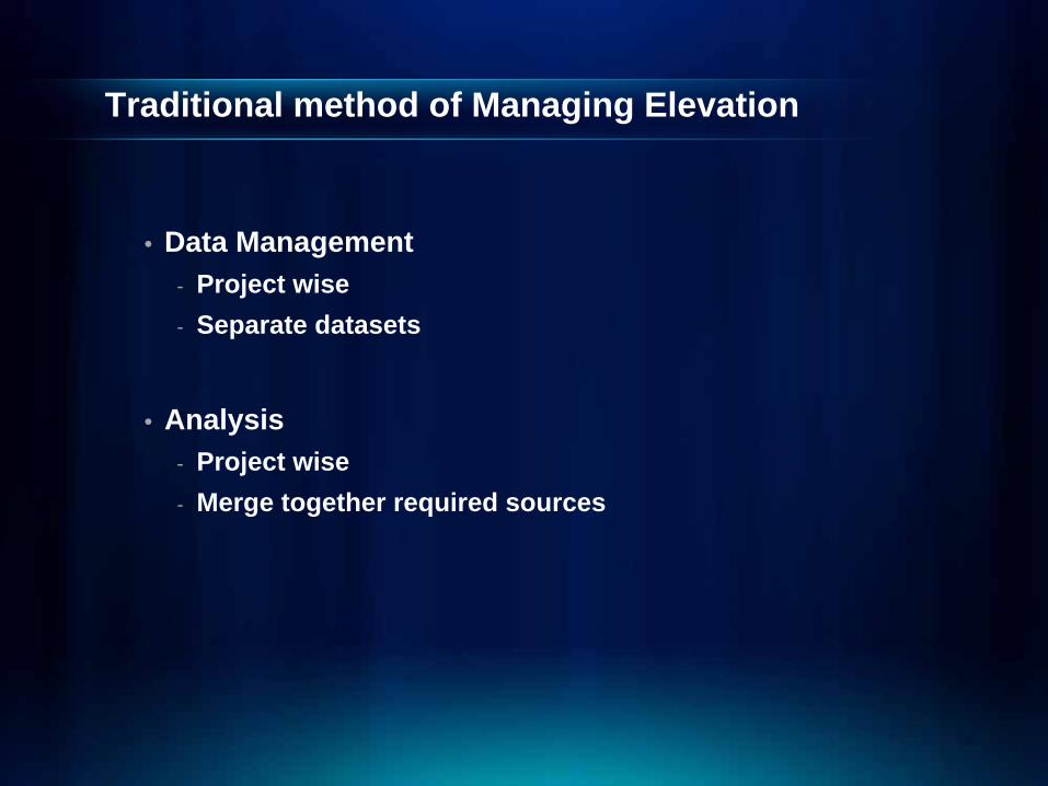
Traditional method of Managing Elevation
• Data Management- Project wise- Separate datasets
• Analysis- Project wise- Merge together required sources
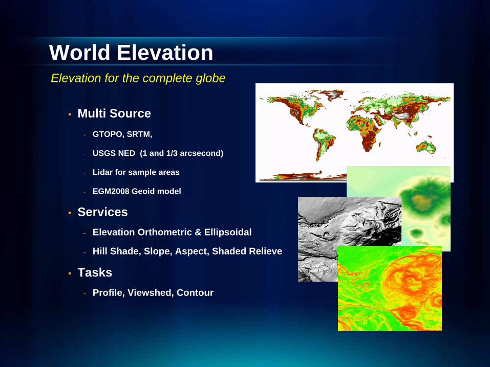
World Elevation
• Multi Source- GTOPO, SRTM,
- USGS NED (1 and 1/3 arcsecond)
- Lidar for sample areas
- EGM2008 Geoid model
• Services- Elevation Orthometric & Ellipsoidal
- Hill Shade, Slope, Aspect, Shaded Relieve
• Tasks- Profile, Viewshed, Contour
Elevation for the complete globe
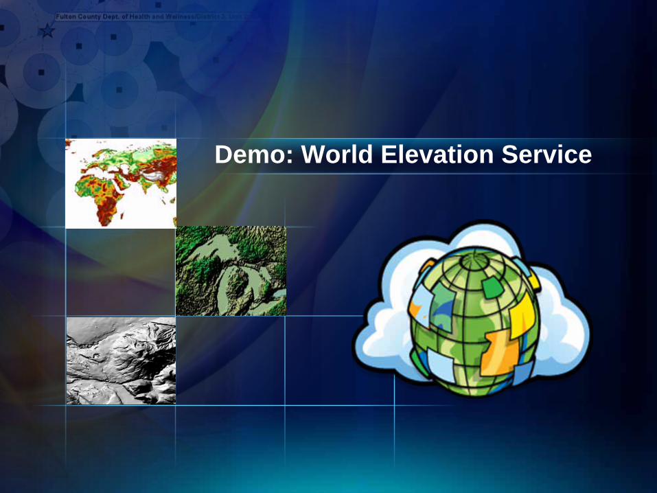
Demo: World Elevation Service
User Requirements
• Visualization- Hillshade, Slope, Aspect
• Directly using Elevation- Othophoto generation, Contours, Viewshed- Application needs elevation (or slope,…)
• Analysis Results- Visibility, Viewshed, Contours- User only gets results
• Data download & export
These requirements can best be achieved using Image Services
Data Management Requirements
• Single Service from multiple sources- Simplifies data management and dissemination
• Create Derived Service for different- Visual representations- Orthometric vs Ellipsoidal- Surface Elev. (DSM) vs. Ground Elev, (DEM)
• Set up server side analysis services
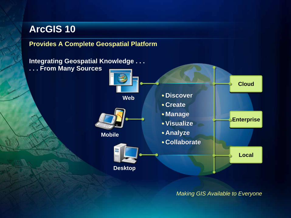
•• DiscoverDiscover•• CreateCreate•• ManageManage•• VisualizeVisualize•• AnalyzeAnalyze•• CollaborateCollaborate
ArcGIS 10Provides A Complete Geospatial Platform
Making GIS Available to Everyone
Web
Mobile
Desktop
CloudCloud
EnterpriseEnterprise
LocalLocal
Integrating Geospatial Knowledge . . .. . . From Many Sources
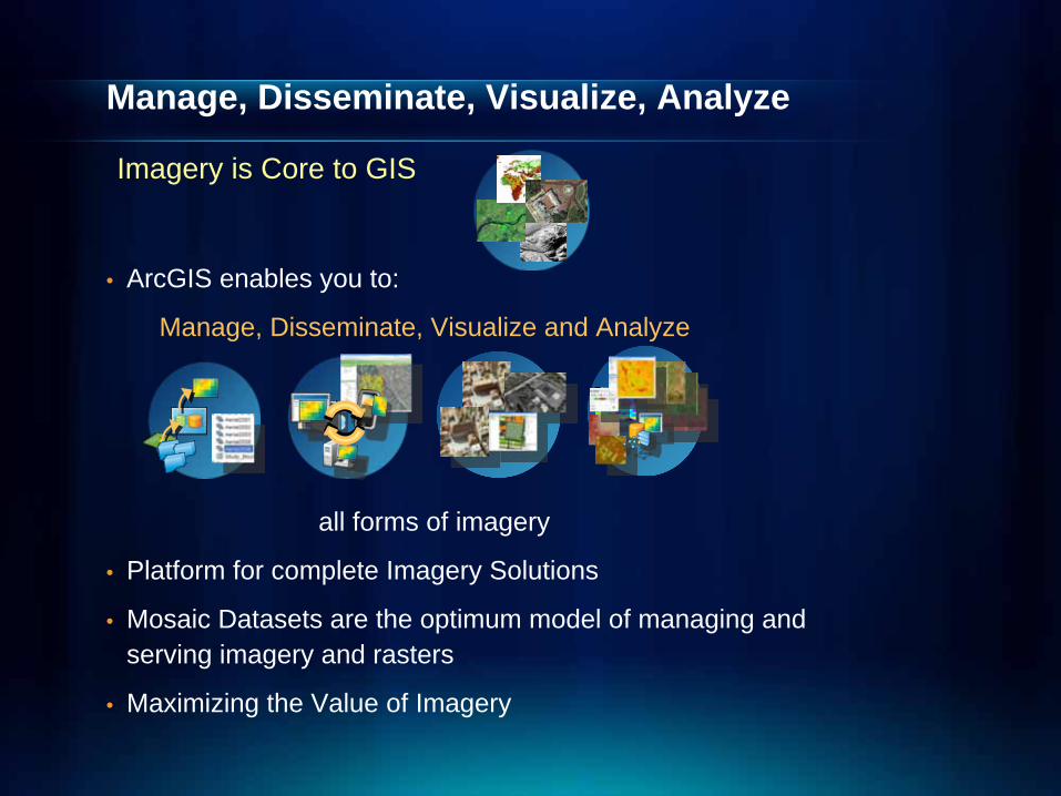
Manage, Disseminate, Visualize, Analyze
• ArcGIS enables you to:
Manage, Disseminate, Visualize and Analyze
all forms of imagery
• Platform for complete Imagery Solutions
• Mosaic Datasets are the optimum model of managing and serving imagery and rasters
• Maximizing the Value of Imagery
Imagery is Core to GIS

Managing & Serving Elevation Data
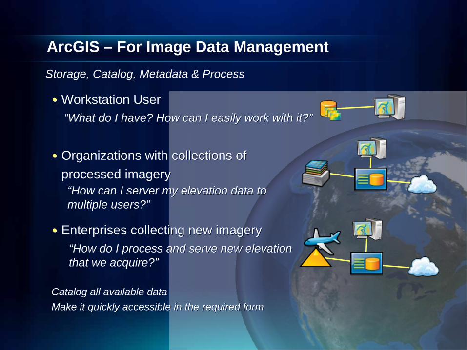
ArcGIS – For Image Data Management
•• Workstation UserWorkstation User
•• Organizations with collections ofOrganizations with collections ofprocessed imageryprocessed imagery
•• Enterprises collecting new imageryEnterprises collecting new imagery
““How can I server my elevation data to How can I server my elevation data to multiple users?multiple users?””
““How do I process and serve new elevation How do I process and serve new elevation that we acquire?that we acquire?””
““What do I have? How can I easily work with it?What do I have? How can I easily work with it?””
Catalog all available dataCatalog all available dataMake it quickly accessible in the required formMake it quickly accessible in the required form
Storage, Catalog, Metadata & Process
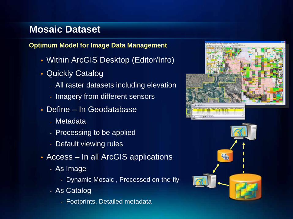
Mosaic DatasetMosaic Dataset
• Within ArcGIS Desktop (Editor/Info)• Quickly Catalog
- All raster datasets including elevation- Imagery from different sensors
• Define – In Geodatabase- Metadata- Processing to be applied- Default viewing rules
• Access – In all ArcGIS applications- As Image
- Dynamic Mosaic , Processed on-the-fly
- As Catalog- Footprints, Detailed metadata
Optimum Model for Image Data Management
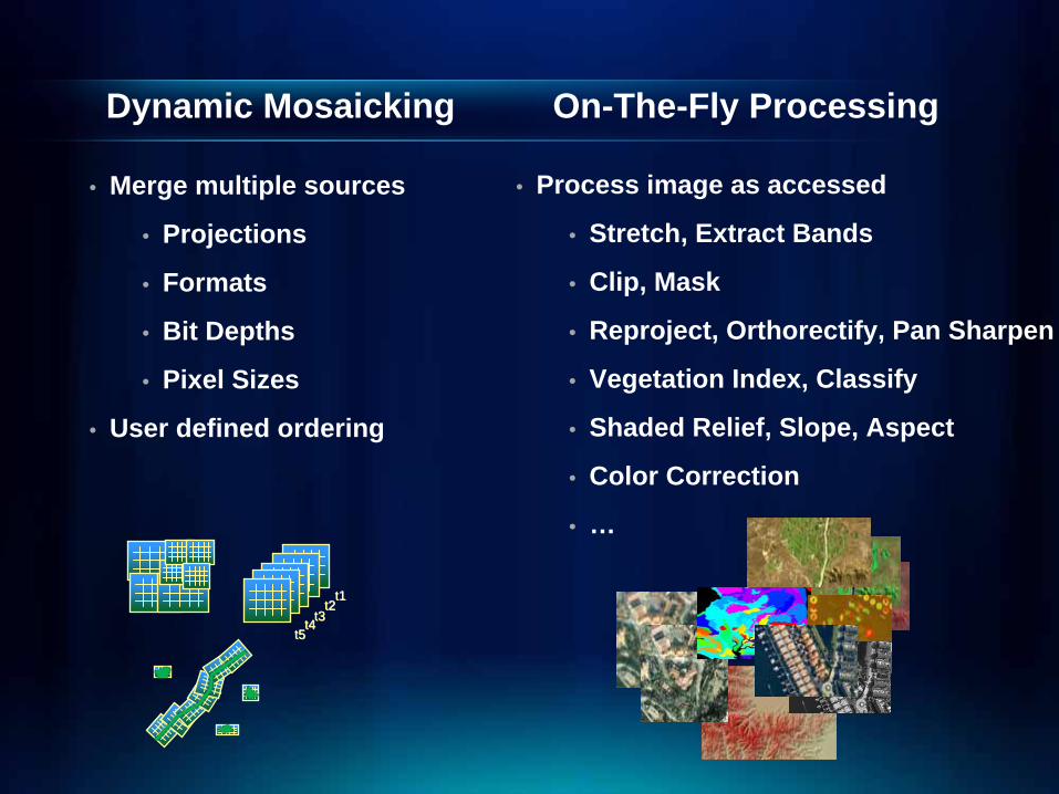
Dynamic Mosaicking On-The-Fly Processing
• Process image as accessed
• Stretch, Extract Bands
• Clip, Mask
• Reproject, Orthorectify, Pan Sharpen
• Vegetation Index, Classify
• Shaded Relief, Slope, Aspect
• Color Correction
• …
• Merge multiple sources
• Projections
• Formats
• Bit Depths
• Pixel Sizes
• User defined ordering
t1t1t2t2
t3t3t4t4t5t5
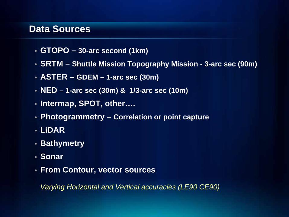
Data Sources
• GTOPO – 30-arc second (1km)
• SRTM – Shuttle Mission Topography Mission - 3-arc sec (90m)
• ASTER – GDEM – 1-arc sec (30m)
• NED – 1-arc sec (30m) & 1/3-arc sec (10m)
• Intermap, SPOT, other….• Photogrammetry – Correlation or point capture
• LiDAR• Bathymetry• Sonar• From Contour, vector sources
Varying Horizontal and Vertical accuracies (LE90 CE90)
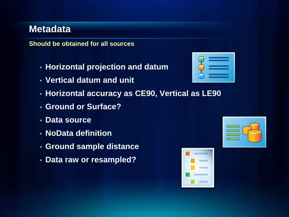
MetadataShould be obtained for all sources
• Horizontal projection and datum• Vertical datum and unit• Horizontal accuracy as CE90, Vertical as LE90• Ground or Surface?• Data source• NoData definition• Ground sample distance• Data raw or resampled?
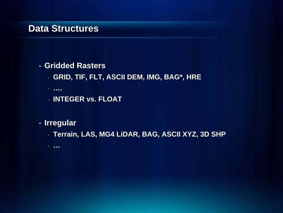
Data Structures
• Gridded Rasters- GRID, TIF, FLT, ASCII DEM, IMG, BAG*, HRE- ….- INTEGER vs. FLOAT
• Irregular- Terrain, LAS, MG4 LiDAR, BAG, ASCII XYZ, 3D SHP- …
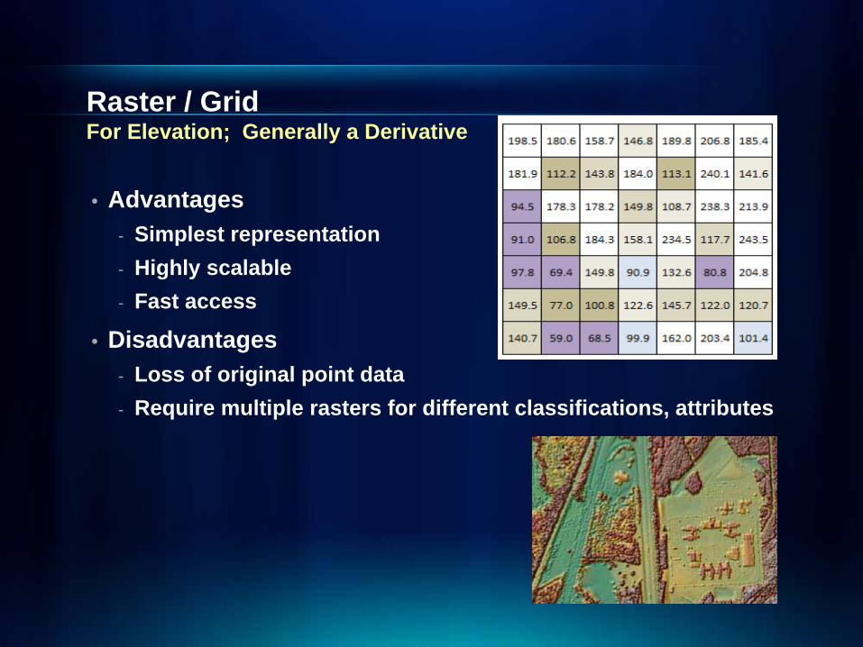
Raster / Grid For Elevation; Generally a Derivative
• Advantages- Simplest representation- Highly scalable- Fast access
• Disadvantages- Loss of original point data- Require multiple rasters for different classifications, attributes
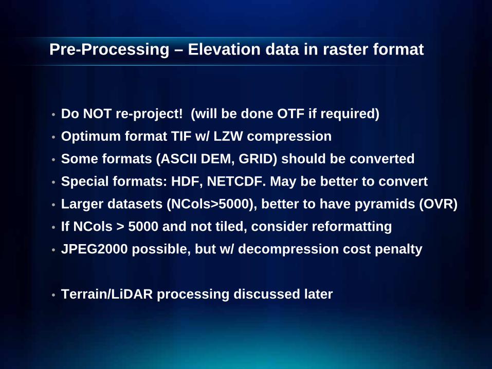
Pre-Processing – Elevation data in raster format
• Do NOT re-project! (will be done OTF if required)• Optimum format TIF w/ LZW compression• Some formats (ASCII DEM, GRID) should be converted• Special formats: HDF, NETCDF. May be better to convert• Larger datasets (NCols>5000), better to have pyramids (OVR)• If NCols > 5000 and not tiled, consider reformatting• JPEG2000 possible, but w/ decompression cost penalty
• Terrain/LiDAR processing discussed later
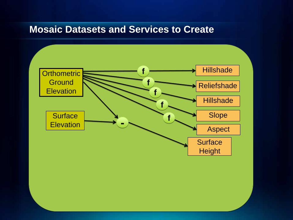
Mosaic Datasets and Services to Create
OrthometricGround
Elevation
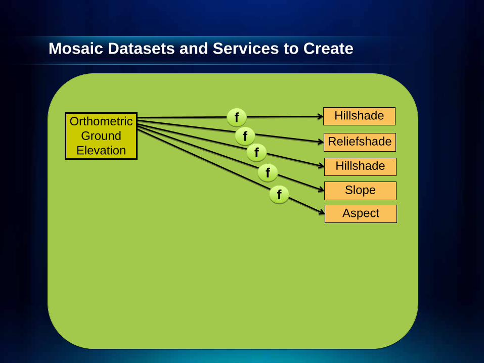
Mosaic Datasets and Services to Create
OrthometricGround
ElevationReliefshade
Slope
Hillshade
Hillshade
Aspect
ffff
ffff
ff
Mosaic Datasets and Services to Create
OrthometricGround
Elevation
Surface Elevation --
Reliefshade
Slope
Hillshade
Hillshade
Aspect
Surface Height
ffff
ffff
ff

Mosaic Datasets and Services to Create
OrthometricGround
Elevation
Surface Elevation --
Reliefshade
Slope
Hillshade
Hillshade
Aspect
Surface Height
ffff
ffff
ff
Orthometric HeightMSL
Ground
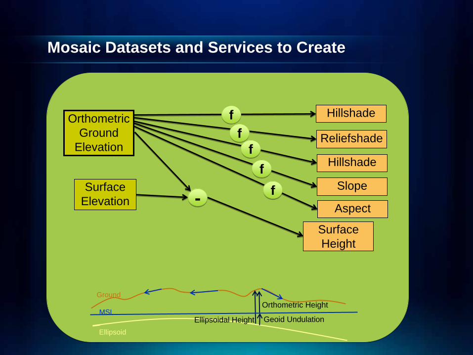
Mosaic Datasets and Services to Create
OrthometricGround
Elevation
Surface Elevation --
Reliefshade
Slope
Hillshade
Hillshade
Aspect
Surface Height
ffff
ffff
ff
Orthometric Height
Ellipsoidal HeightMSL
Ground
Ellipsoid
Mosaic Datasets and Services to Create
OrthometricGround
Elevation
Surface Elevation --
Reliefshade
Slope
Hillshade
Hillshade
Aspect
Surface Height
ffff
ffff
ff
Orthometric Height
Ellipsoidal Height Geoid UndulationMSL
Ground
Ellipsoid
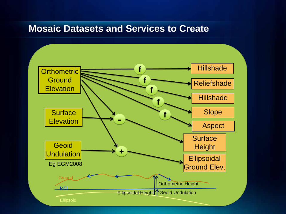
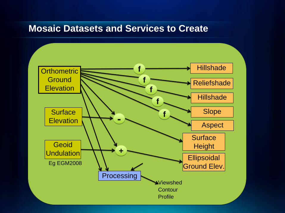
Mosaic Datasets and Services to Create
OrthometricGround
Elevation
Surface Elevation
GeoidUndulation
--
EllipsoidalGround Elev.
Reliefshade
Slope
Hillshade
Hillshade
Aspect
Eg EGM2008
Surface Height
++
ffff
ffff
ff
Orthometric Height
Ellipsoidal Height Geoid UndulationMSL
Ground
Ellipsoid
Mosaic Datasets and Services to Create
OrthometricGround
Elevation
Surface Elevation
GeoidUndulation
--
EllipsoidalGround Elev.
Reliefshade
Slope
Hillshade
Hillshade
Aspect
Eg EGM2008
Surface Height
++
Processing
ffff
ffff
ff
ViewshedContourProfile
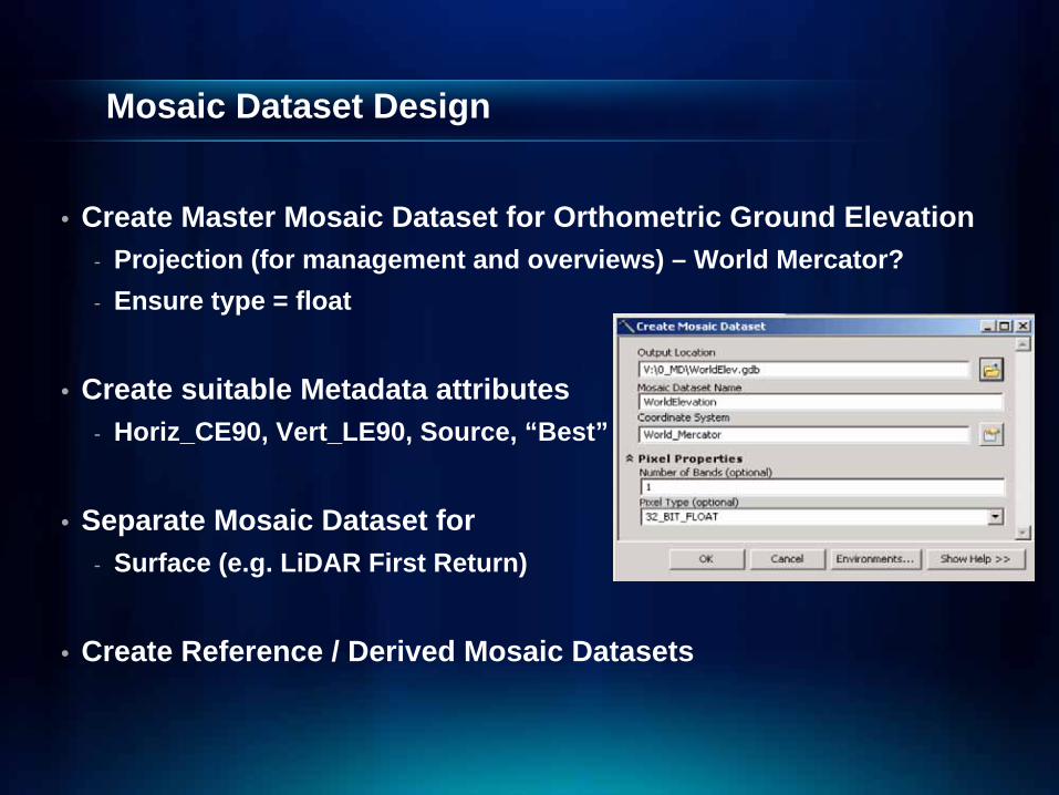
Mosaic Dataset Design
• Create Master Mosaic Dataset for Orthometric Ground Elevation- Projection (for management and overviews) – World Mercator?- Ensure type = float
• Create suitable Metadata attributes- Horiz_CE90, Vert_LE90, Source, “Best”
• Separate Mosaic Dataset for- Surface (e.g. LiDAR First Return)
• Create Reference / Derived Mosaic Datasets
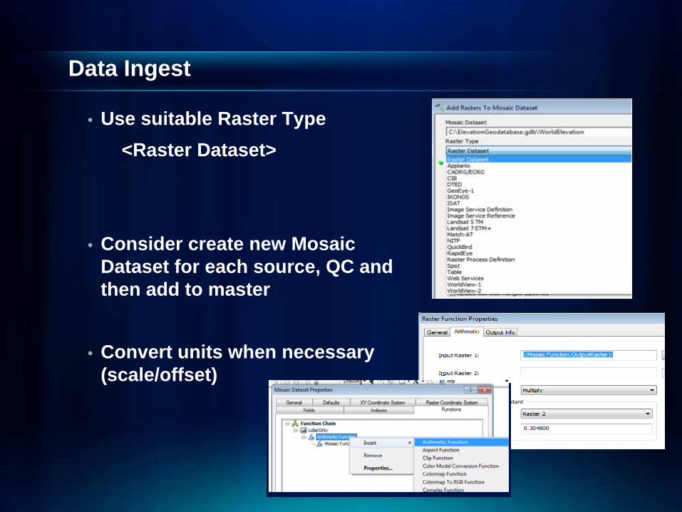
Data Ingest
• Use suitable Raster Type <Raster Dataset>
• Consider create new Mosaic Dataset for each source, QC and then add to master
• Convert units when necessary (scale/offset)
Demo – Create Mosaic Datasets and Ingest Data
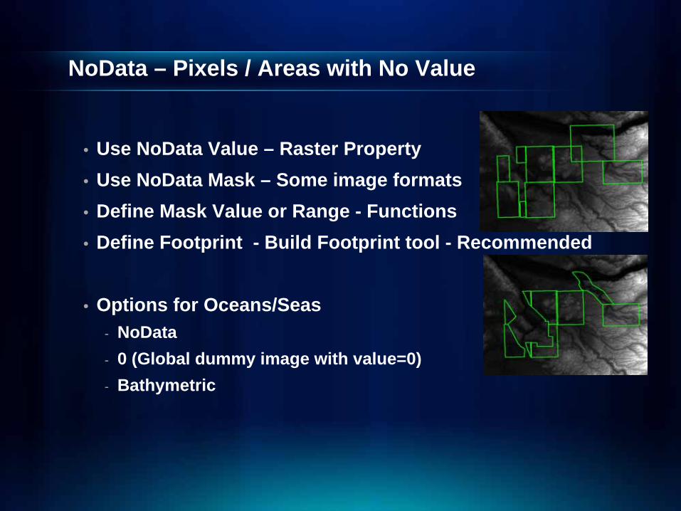
NoData – Pixels / Areas with No Value
• Use NoData Value – Raster Property• Use NoData Mask – Some image formats• Define Mask Value or Range - Functions• Define Footprint - Build Footprint tool - Recommended
• Options for Oceans/Seas- NoData- 0 (Global dummy image with value=0)- Bathymetric

Demo – NoData
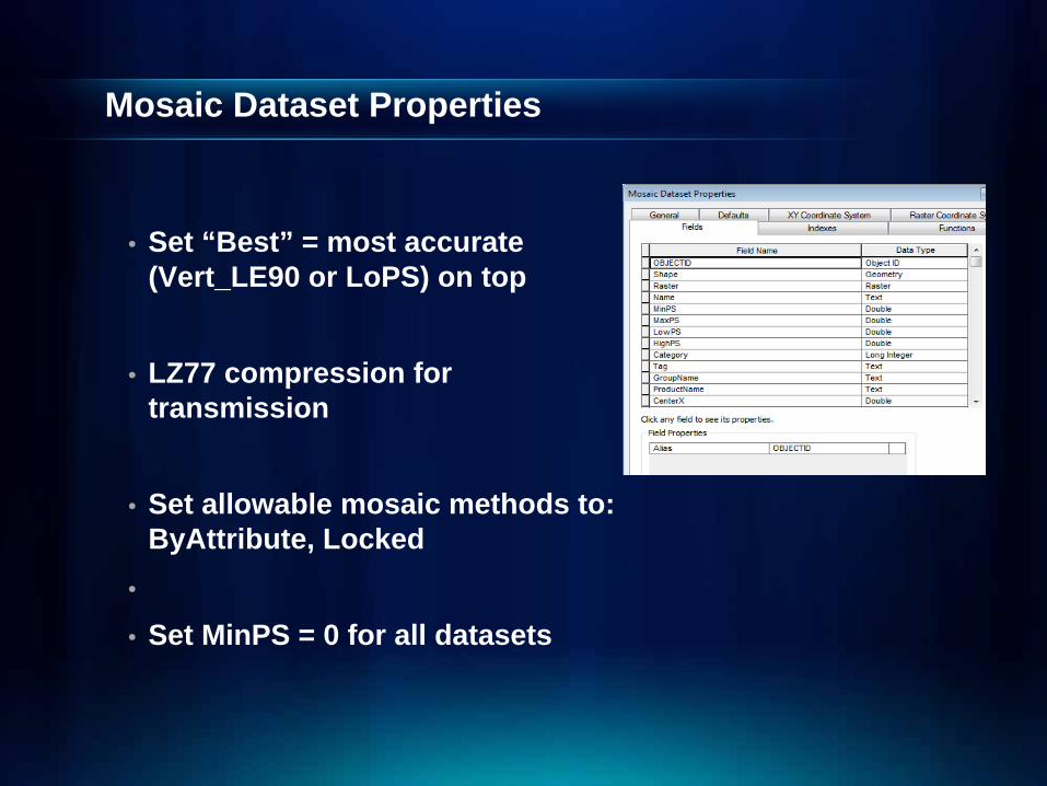
Mosaic Dataset Properties
• Set “Best” = most accurate (Vert_LE90 or LoPS) on top
• LZ77 compression for transmission
• Set allowable mosaic methods to: ByAttribute, Locked
•
• Set MinPS = 0 for all datasets
Overviews
• Define provide fast access to small scales• Can be generated – from primary data• Advantageous to use global data sources such as
SRTM and GTOPO to mitigate the requirement for creating overviews
• Review NoData values in overviews
Demo – Mosaic Dataset Properties
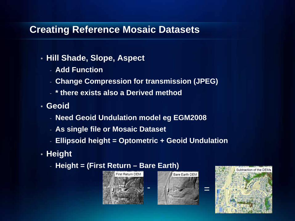
Creating Reference Mosaic Datasets
• Hill Shade, Slope, Aspect- Add Function- Change Compression for transmission (JPEG)- * there exists also a Derived method
• Geoid- Need Geoid Undulation model eg EGM2008- As single file or Mosaic Dataset- Ellipsoid height = Optometric + Geoid Undulation
• Height- Height = (First Return – Bare Earth)
- =
Demo – Reference Mosaic Datasets
Optimization & Maintenance
• New data can be added as required to master• Reference Mosaic Datasets are automatically updated• Consider optimizing formats• If a lot of Nodata Areas
- Consider to generate tiles to minimize NoData processing
Applications using Elevation based Image Services
• Serve Visualization- Direct use of Hillshade, Slope, Aspect
• Directly Using Elevation - Client downloads source data for local processing- Recommendation: Try to minimize this usage mode
• Serve Analysis Results- Tools to perform on-demand analysis on server- Viewshed, Profile, Contours
• In any of 3 uses above, client application can be:- ArcGIS (for further technical analysis)- Other web apps (ArcExplorer, custom apps, etc.)
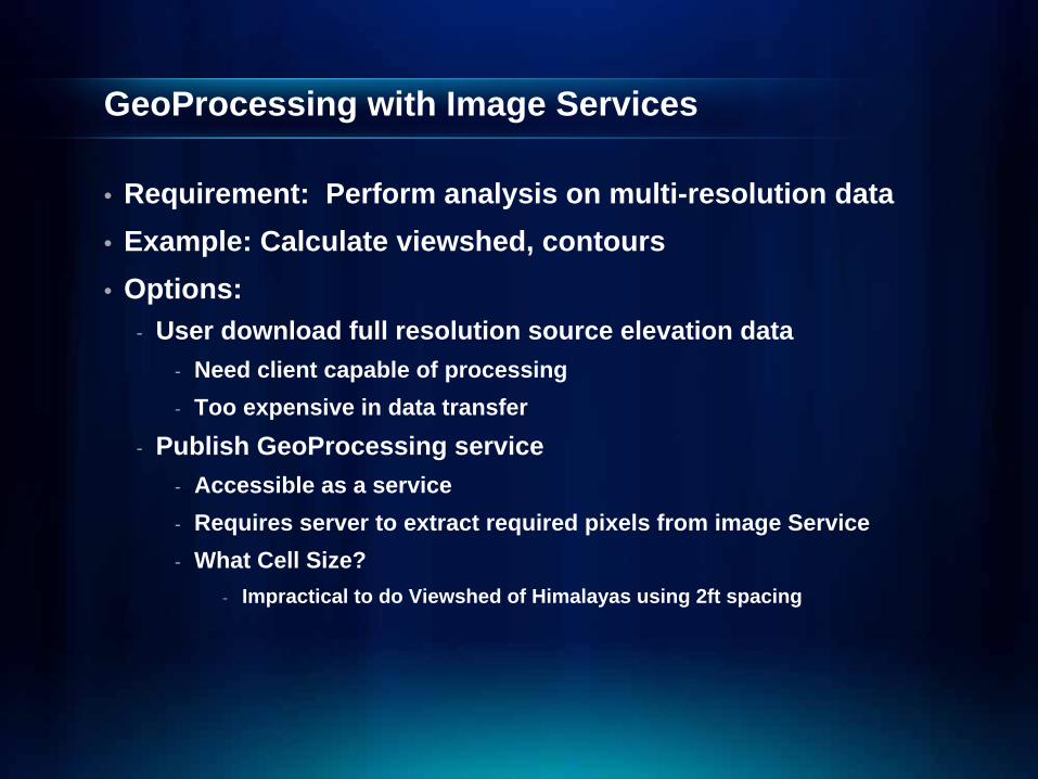
GeoProcessing with Image Services
• Requirement: Perform analysis on multi-resolution data• Example: Calculate viewshed, contours• Options:
- User download full resolution source elevation data- Need client capable of processing- Too expensive in data transfer
- Publish GeoProcessing service - Accessible as a service- Requires server to extract required pixels from image Service- What Cell Size?
- Impractical to do Viewshed of Himalayas using 2ft spacing
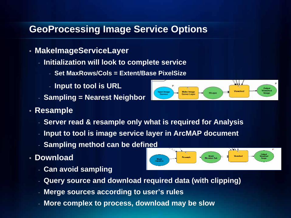
GeoProcessing Image Service Options
• MakeImageServiceLayer- Initialization will look to complete service
- Set MaxRows/Cols = Extent/Base PixelSize
- Input to tool is URL- Sampling = Nearest Neighbor
• Resample- Server read & resample only what is required for Analysis- Input to tool is image service layer in ArcMAP document- Sampling method can be defined
• Download- Can avoid sampling- Query source and download required data (with clipping)- Merge sources according to user’s rules- More complex to process, download may be slow
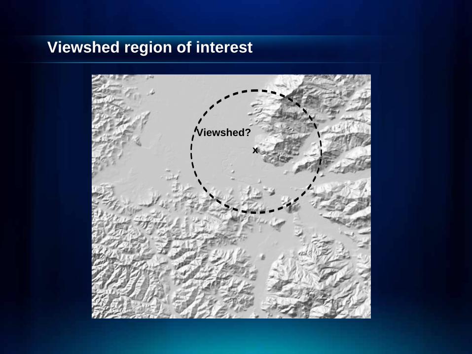
Viewshed region of interest
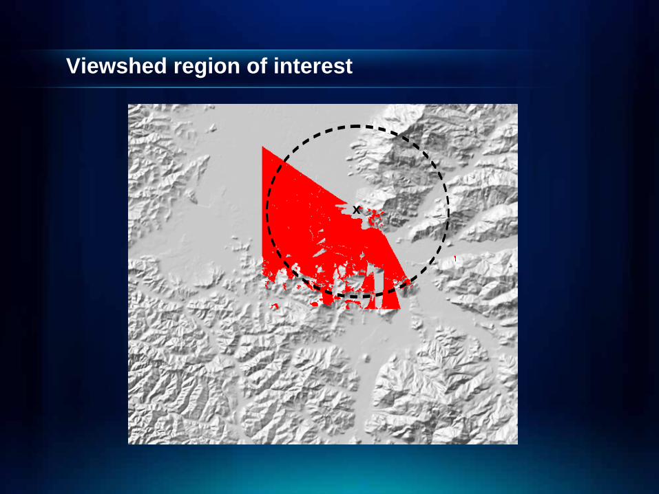
Viewshed?x
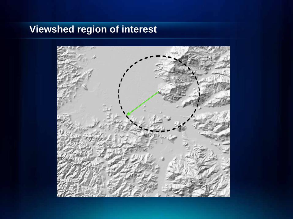
Viewshed region of interest
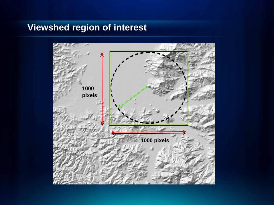
Viewshed region of interest
1000 pixels
1000 pixels
Viewshed region of interest
x
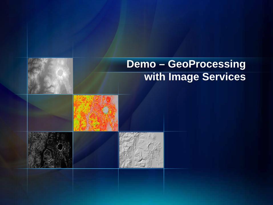
Demo – GeoProcessing with Image Services
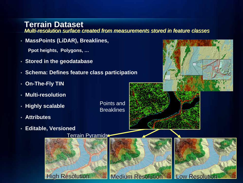
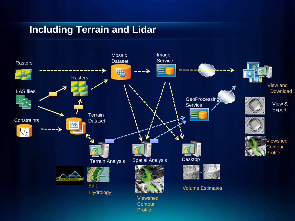
Terrain Dataset
• MassPoints (LiDAR), Breaklines,
Ppot heights, Polygons, …
• Stored in the geodatabase
• Schema: Defines feature class participation
• On-The-Fly TIN
• Multi-resolution
• Highly scalable
• Attributes
• Editable, Versioned
Points and Points and BreaklinesBreaklines
Terrain PyramidsTerrain Pyramids
Low ResolutionLow ResolutionMedium ResolutionMedium ResolutionHigh ResolutionHigh Resolution
MultiMulti--resolution surface created from measurements stored in feature cresolution surface created from measurements stored in feature classeslasses
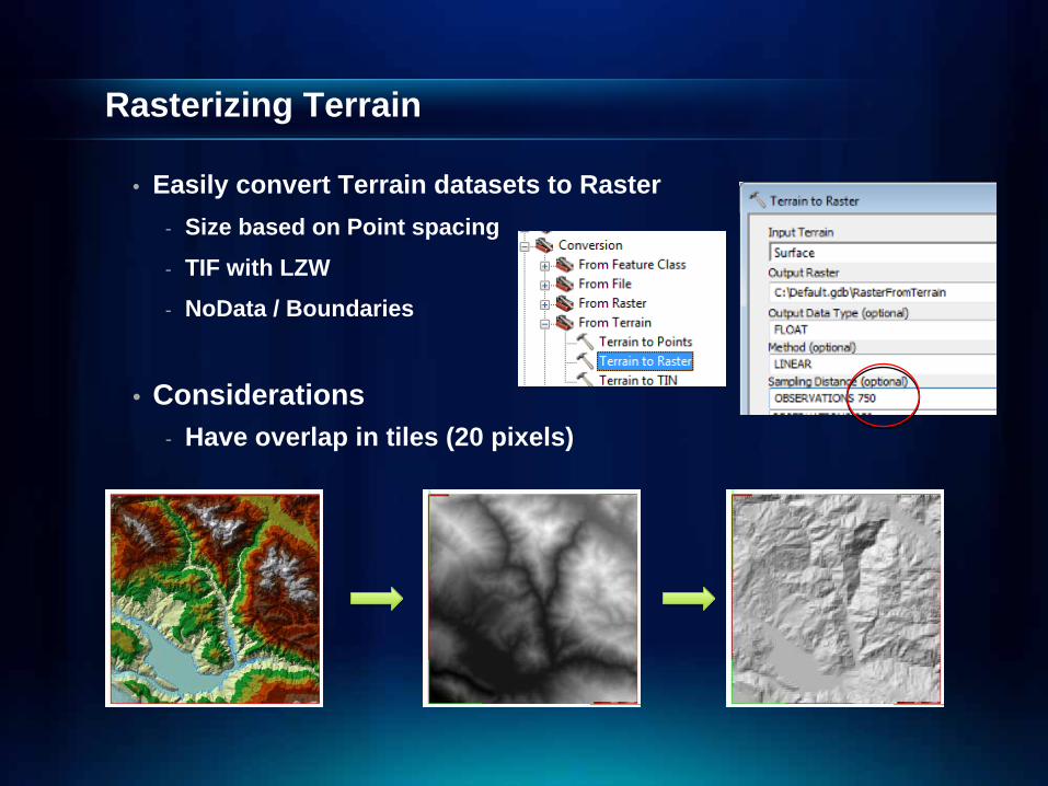
Rasterizing Terrain
• Easily convert Terrain datasets to Raster- Size based on Point spacing
- TIF with LZW
- NoData / Boundaries
• Considerations- Have overlap in tiles (20 pixels)
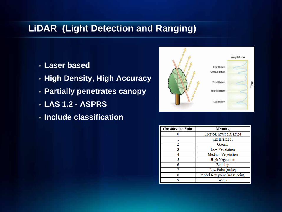
LiDAR (Light Detection and Ranging)
• Laser based• High Density, High Accuracy• Partially penetrates canopy• LAS 1.2 - ASPRS• Include classification
Rasterizing LiDAR
• Import LAS to Multi-point; Then, two methods: (1) Raster via Terrain
- Point File Information (Avg. point spacing)
- Terrain Wizard; 2 Terrains for First and Last (Ground) Return
- NoData “holes” filled by TIN
- QC and Edit Terrain to Raster (previous slide)
(2) Interpolate Multi-point directly to Raster- Point to Raster; Set Point Set cell size to 4x avg. point spacing
- Filter to remove holes: Con(IsNull("INPUTRASTER"), FocalStatistics("INPUTRASTER", NbrRectangle(3,3, "CELL"), "MEAN", "DATA"), "INPUTRASTER")
• 3rd Party Tools- Eg LP360 (QCoherent)
• Considerations- Have overlap in tiles (20 pixels)
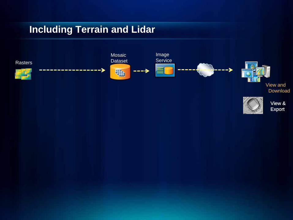
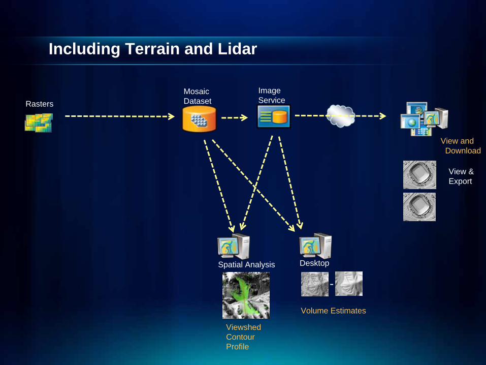
Including Terrain and Lidar
MosaicDataset
View &Export
ImageService
View andDownload
Rasters
View &Export
Including Terrain and Lidar
MosaicDataset
View &Export
ImageService
View andDownload
Spatial Analysis
Volume Estimates
ViewshedContourProfile
Rasters
Desktop
-
Including Terrain and Lidar
MosaicDataset
View &Export
ImageService
View andDownload
Spatial Analysis
Volume Estimates
ViewshedContourProfile
Rasters
Desktop
-
GeoProcessingService
ViewshedContourProfile
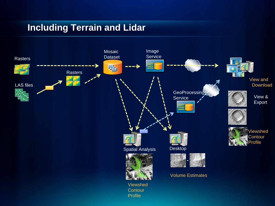
Including Terrain and Lidar
MosaicDataset
View &Export
ImageService
View andDownload
Spatial Analysis
Volume Estimates
ViewshedContourProfile
Rasters
Desktop
-
GeoProcessingService
ViewshedContourProfile
LAS files
Rasters
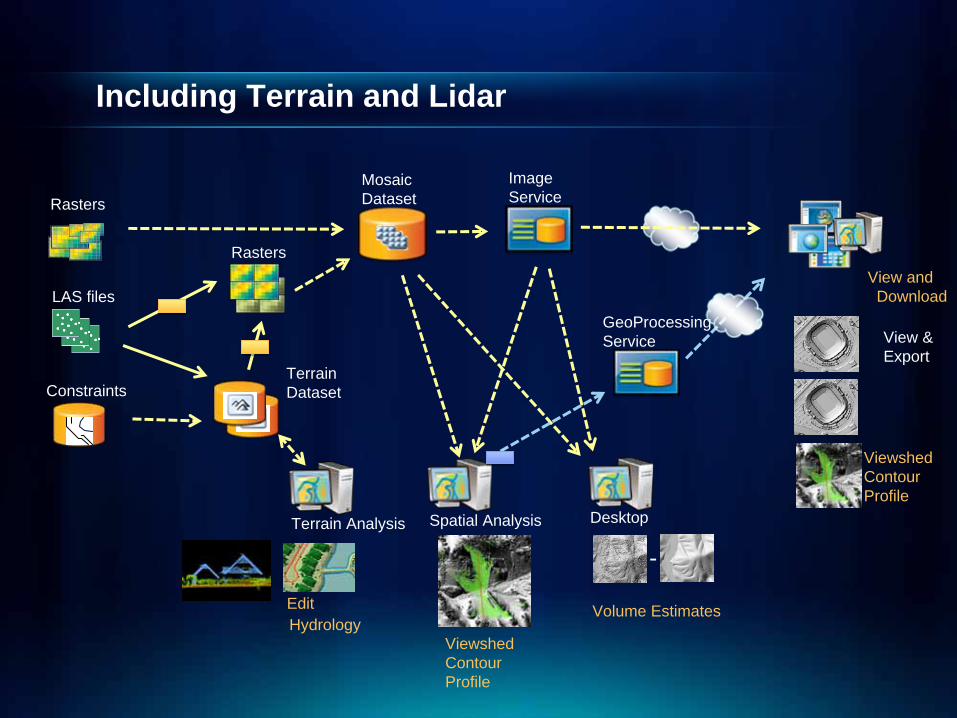
Including Terrain and Lidar
MosaicDataset
View &Export
ImageService
View andDownload
Spatial Analysis
Volume Estimates
ViewshedContourProfile
Rasters
Desktop
-
GeoProcessingService
ViewshedContourProfile
LAS files
Rasters
Constraints
Hydrology
Terrain Analysis
TerrainDataset
Edit
Including Terrain and Lidar
MosaicDataset
View &Export
ImageService
View andDownload
Spatial Analysis
Volume Estimates
ViewshedContourProfile
Rasters
Desktop
-
GeoProcessingService
ViewshedContourProfile
LAS files
Rasters
Constraints
Hydrology
Terrain Analysis
TerrainDataset
Edit
Summary
• Serving Elevation data involves many details! • Features in ArcGIS 10 focused on improving
efficiency and data management- Mosaic Dataset- Image Services via SOAP, REST, WMS, WCS, KML…
• Best Practices workflows are under development- Emphasis on the Data Manager
• Increased LiDAR support • Much more to come!

Please Fill Out Evaluation Forms Your comments help us meet your conference needs each year.
Thank you…
Any Questions?