Embed Size (px)
Citation preview

FROM LEVELING TO SAR‐BASED INTERFEROMETRY: ADVANCES IN KNOWLEDGE
AND UNDERSTANDING OF CAUSES, PREVENTION AND MITIGATION COASTAL
SUBSIDENCE IN VENICE
Luigi TosiInstitute of Geosciences and Earth Resources – National Research Council, Italy
Workshop for Land Subsidence Prevention
May 14th, 2019

m
The Venice Region is located in the northwestern Adriatic coastland between thePo River delta and the Tagliamento River.The Venice coastland is part of the largest Italian low‐lying plain with groundelevation up to 5 m below the sea level or only 2‐3 m above it.
SRTM ground elevation
Venice Region: Morpho‐physiographic setting
Venice
SRTM ground elevation
Workshop for Land Subsidence Prevention, May 14th, 2019
SRTM ground elevation
Alps
Po Plain

AdriaticSea
Po Riverdelta
Low‐lyingareas
Low‐lyingareas
The Venice coast: heterogenous transitional environment
Touristic centers
Historical heritages
Hydraulic reclamation and low‐lying farmlands
Fish farmsSalt marshes
Tidal flats
Industrial area
The Venice area is formed by a transitional coastal system located between land and sea.
Natural‐ and human‐controlled environments such as lagoons, estuaries, wetland, farmlands, urban and industrial areas coexist and interact together.
Inlets and littorals protecting the lagoon
Workshop for Land Subsidence Prevention, May 14th, 2019
INTRODUCTION
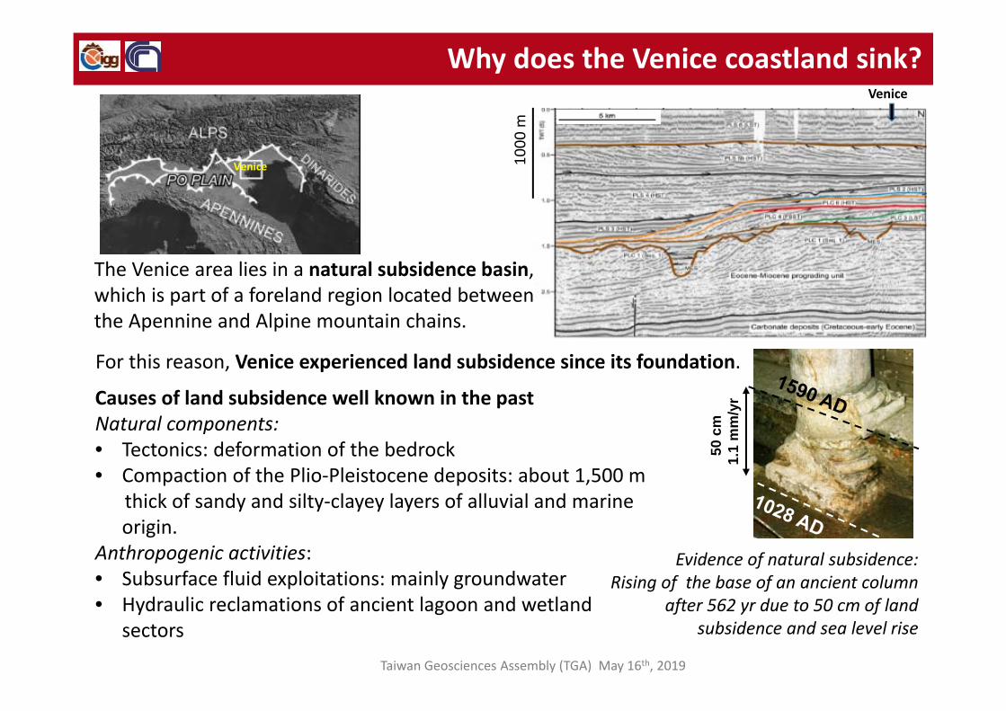
Causes of land subsidence well known in the pastNatural components:• Tectonics: deformation of the bedrock• Compaction of the Plio‐Pleistocene deposits: about 1,500 m
thick of sandy and silty‐clayey layers of alluvial and marine origin.
Anthropogenic activities:• Subsurface fluid exploitations: mainly groundwater• Hydraulic reclamations of ancient lagoon and wetland
sectors
Venice
Why does the Venice coastland sink?
1000
m
Venice
Evidence of natural subsidence:Rising of the base of an ancient column
after 562 yr due to 50 cm of land subsidence and sea level rise
50 c
m
1.1
mm
/yr
The Venice area lies in a natural subsidence basin, which is part of a foreland region located between the Apennine and Alpine mountain chains.
Taiwan Geosciences Assembly (TGA) May 16th, 2019
For this reason, Venice experienced land subsidence since its foundation.

Coastal subsidence and eustacy:Relative Sea Level Rise
Land subsidence in the Venice area is in the order of a few mm/yr, hence, it is not highin magnitude compared to other cases in the world that reach up to several cm/yr.
However, land subsidence combined with the small ground elevation above the meansea level and the eustatic rise of the North Adriatic Sea has made Venice increasinglyprone to flooding.
Land subsidence also contribute to the Relative Sea Level Rise (RSLR) exacerbating the effectof flooding due to the high tides.
Workshop for Land Subsidence Prevention, May 14th, 2019

Effect of Relative Sea Level Rise in Venice
Wooden walkways
+194 cm amsl
+156 cm amsl
+194 cm amsl
+156 cm amsl
Given that: ‐ ground surface of the historical center of Venice is only a few decimeters higher
than that of the average tide level,‐ ground surface of the coastal plain is mostly below the mean sea level,‐ elevation lost due to land subsidence is irreversible,‐ sea level rise due to climate changes is increasing,
even a few mm loss of ground elevation seriously compromise the survival of the historical and natural heritage of Venice and its lagoon and highly concerns the safety of the low‐lying farmlands in the mainland.
Workshop for Land Subsidence Prevention, May 14th, 2019

Past Land Subsidence monitoring: First leveling network
Regional leveling networkLength: 250 kmBenchmark spacing: 1 km Accuracy: about 1.5 mm (first order spirit leveling)
Historical center leveling networkAbout 120 benchmarksBenchmark spacing: 150‐300 mAccuracy: about 1.5 mm (first order spirit leveling)
Workshop for Land Subsidence Prevention, May 14th, 2019
Because of the fragility and the high value of Venice and its lagoon, land subsidence has always been a major issue that requires high accuracy in monitoring ground movements and a deep knowledge of cause‐effect relationships.
The first subsidence monitoring network was established in the 1950s when the Venice area began to experience serious sinking rates due to groundwater exploitation.

In the 1960s anthropogenic land subsidence due to the groundwater exploitations (industrial use and touristic purpose) seriously affected Venice.
From 1950 to 1970: water level decreased 10‐15 m
Evolution of groundwaterpressures
From 1950 to 1970 the groundwater level decreased by 10‐15 m.In 1970 groundwater pumping in Venice was prohibited and the subsidence of the City significantly reduced.
IndustrialArea
Lido Littoral
Past groundwater pumping areas
INTRODUCTION
1952‐1970 Groundwater exploitationInduced subsidence
Past Land Subsidence monitoring: groundwater exploitation
1973‐1993Exploitation banNatural subsidence
Workshop for Land Subsidence Prevention, May 14th, 2019

• Severe land subsidence in the 1960s due to groundwater exploitation, up to 1 cm/year.• A slight rebound of a few mm for a short period, i.e., 1969‐1973, as consequence of the
closure of the wells. • Natural subsidence rates from 1973 to 1993, i.e. less than 1.5 mm/year, as consequence
of the groundwater exploitation ban in the Municipality of Venice.
‐ 1969: Maximum subsidence rate due to groundwater exploitation.
‐ 1970: Closure of the wells.
‐ 1973‐1993: Natural subsidence
Past Land Subsidence monitoring:from induced to natural rates
Groundwater:Exploitation:about 1 cm/yr
Stop pumping:slight uplift
Quite homogeneous natural trend 1mm/yr
The leveling network allowed an accurate monitoring of ground displacements in the historical center over the period 1961‐1993.
Workshop for Land Subsidence Prevention, May 14th, 2019

Past Land Subsidence monitoring:from induced to natural rates
A
B C
H
C H
A CBIndustrialZone Chioggia
Littoral Jetties and littoral protection work
sinking
Hydraulic reclamation
The lagoon margins and the littorals were also monitored in detail. The reduction of the subsidence rates in the industrial zone have been confirmed over the 1973‐1993 period, while sinking sectors have been
observed in correspondence of low‐lying farmlands and the inlets.
Workshop for Land Subsidence Prevention, May 14th, 2019
Leveling network installed along
the lagoon margin and
littorals

A
B
C
DE
A B DC ED
Ground movements measured in the 1993‐2000 period confirmed the stability of historical center and industrial zone, and highlighted an increase in sinking rates towards the northern and southern lagoon margins because of hydraulic reclamation and groundwater pumping.
Tectonics
Groundwaterpumping
C EB
Hydraulic reclamation Groundwater
pumping
Tectonics
Workshop for Land Subsidence Prevention, May 14th, 2019
Past Land Subsidence monitoring:natural rates and new induced sinking sectors

These results raised new concerns on land subsidence and in 2000, the Authorities responsible for the costal management (e.g., water authority of Venice, land reclamation authorities, municipalities) joined together to support a research project aimed to update the knowledge of the process, including the extension of the monitoring network in areas never investigated before.
?
?
Both maps show:• Similar subsidence images obtained for both periods.• Negligible subsidence in the central lagoon.• Sinking trends increasing northward and southward to
more than 5 mm/year in correspondence of low‐lying coastland sectors with high hydrogeological risk.
Hydraulic reclamation
Groundwaterpumping
Workshop for Land Subsidence Prevention, May 14th, 2019
Past Land Subsidence monitoring:natural rates and new induced sinking sectors

1950s-2000
2001
2005
2009
Leveling network: 250 kmBenchmark spacing: 1 km
Leveling: 1200 kmGPS benchmark: 120
Leveling: 2000 kmGPS benchmark: 180
Leveling: 2100 km (2500 benchmarks)GPS benchmark: 200
A continuous effort has been devoted to improve the subsidence monitoring network from 2001 to 2009
From a few hundreds leveling benchmarks to more than 2500 leveling benchmarks, 200 of which also for DGPS measurements
10 km
10 km
Subsidencemonitoringnetwork
Land Subsidence monitoring in the 2000s:new leveling network
Once ascertained that land subsidence is still in progress in the southern and northern Venice coastal areas and in the nearby mainland, the ground movement monitoring network has been progressively extended to cover areas never been investigated in the past
Workshop for Land Subsidence Prevention, May 14th, 2019

Validation of the interferometric data through leveling.
Land Subsidence monitoring in the 2000s:First test of SAR‐based interferometry application in Venice
Leveling1961‐1969
Leveling1973 ‐1993
InSAR1992‐1996
Together with the extension of the leveling and GPS networks, SAR‐based interferometry was applied for monitoring land subsidence.
The first test of SAR interferometry in Venice was carried out in the historical center. Results highlighted:• The stability of Venice historical center,• A good accuracy of the interferometric products.
Workshop for Land Subsidence Prevention, May 14th, 2019

Land Subsidence monitoring in the 2000s:SAR‐based interferometry has become a practice for Venice
The number of Persistent Targets and their spatial resolution increased from less than 100,000 obtained by ERS/ENVISAT (20‐m pixel resolution) to more than 300,000 by TerraSAR‐X and COSMO‐SkyMed (3‐m pixel resolution).
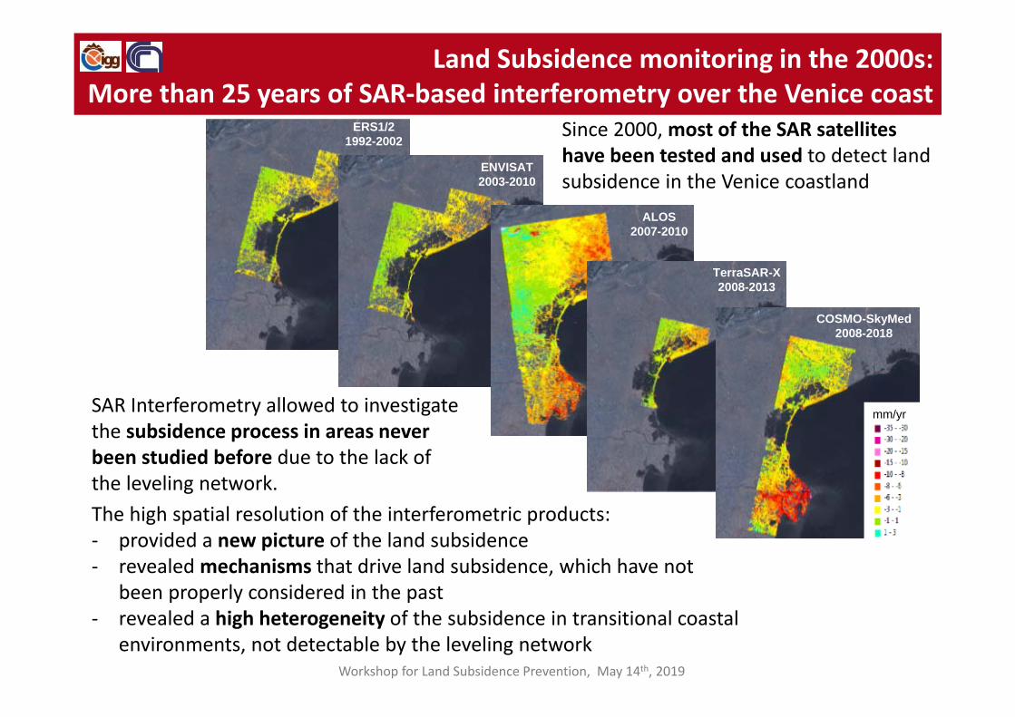
The high spatial resolution of the SAR‐based interferometric products provided a new picture of the land subsidence process. In particular a high heterogeneity of the subsidence not detectable by the leveling network has been observed.
Workshop for Land Subsidence Prevention, May 14th, 2019
ERS
ENVISAT
TerraSAR‐X
COSMO‐SkyMed
Over the time SAR‐based interferometry has continued and most of the SAR satellites have been used.

The first subsidence integrated monitoring system (SIMS) was set up in 2003 and included Leveling, Differential GPS, Continuous GPS, InSAR, and PSI (IPTA) networks.
Leveling1993-2000
GPS1999-2004
InSAR1993-2000
IPTA 1992–2000
In the early 2000s, following the positive results obtained by SAR‐based interferometry, national, regional and local authorities in charge to manage the Venice coastland issues required to set up a new land subsidence monitoring system capable for:‐ providing a comprehensive image of
ground vertical displacements both at regional and local spatial scale,
‐ updating the knowledge on land subsidence controlling mechanisms,
‐ planning solutions to reduce the hydrogeological hazard in hydraulic reclamation areas,
‐ controlling the effect of groundwater exploitations,
Land Subsidence monitoring in the 2000s:The Subsidence Integrated Monitoring System (SIMS),
a new strategy to control land movement at regional scale
Workshop for Land Subsidence Prevention, May 14th, 2019

Land Subsidence monitoring in the 2000s:Mapping regional land displacements by SIMS
Synoptic map of the average displacement rates (1992‐2002) of the Venice region obtained by the integration of the data sets acquired through the Subsidence Integrated Monitoring System (SIMS).
Cross‐validation of leveling, GPS, InSAR, and IPTA results along the
southern lagoon margin.
A B
The SIMS allowed mapping regional land displacements over the whole Venice coastland and mainland. Notice that previous knowledge on land subsidence was limited to the area included in the black rectangle.
A
B
Workshop for Land Subsidence Prevention, May 14th, 2019

GPS time series used for SAR data calibration
ERS 1992-2000 and ENVISAT 2003 -2007
Cumulative 1992-2007 displacements (cm) as obtained by the integration of ERS-1/2 and ENVISAT IPTA results.
Validation: Comparison between leveling and IPTA results
Workshop for Land Subsidence Prevention, May 14th, 2019
Land Subsidence monitoring in the 2000s:Mapping regional land displacements by SIMS
ERS1/21992-2002
ENVISAT2003-2010
ALOS2007-2010
TerraSAR-X2008-2013
COSMO-SkyMed2008-2018
mm/yr
Since 2000, most of the SAR satellites have been tested and used to detect land subsidence in the Venice coastland
Workshop for Land Subsidence Prevention, May 14th, 2019
Land Subsidence monitoring in the 2000s:More than 25 years of SAR‐based interferometry over the Venice coast
The high spatial resolution of the interferometric products:‐ provided a new picture of the land subsidence‐ revealed mechanisms that drive land subsidence, which have not
been properly considered in the past‐ revealed a high heterogeneity of the subsidence in transitional coastal
environments, not detectable by the leveling network
SAR Interferometry allowed to investigate the subsidence process in areas never been studied before due to the lack of the leveling network.

Time series of TCR displacements obtained using ENVISAT and TerraSAR‐X data.An important limitation of SAR‐based
interferometry is the incomplete spatial coverage especially in lagoon and wetlands because of:• Decorrelation does not permit a reliable
analysis of the interferometric phase for parts of the area (INSAR).
• Loss of coherence in vegetated areas and wetlands (PSI).
In order to overcome or at least reduce the limits of SAR interferometry in 2007 about 60 trihedral corner reflectors have been installed in tidal flats and salt marshes
Land Subsidence monitoring in the 2000s:Improving knowledge of ground dynamics in the lagoon basin
by artificial corner reflectors
Workshop for Land Subsidence Prevention, May 14th, 2019

The synergic use of X‐band and L‐band satellites was tested with the aim to take advantage of the different potentialities of the two sensors: • the high accuracy of the displacements
detected by X‐band on even small‐size anthropogenic structures;
• the high temporal coherence over the long time of L‐band allowing detecting displacements over marshlands and crop‐fields.
ALOS-PALSAR L-bandCOSMO-SkyMed X-band
Land Subsidence monitoring in the 2000s: Improving knowledgeby combining SAR data from different band sensors
The proper combining of the L‐ and X‐Band SAR Interferometric products has improved the spatial coverage of ground displacement data in heterogeneous coastal environments, both at regional and local scale.
X‐band and L‐band products combined at regional scale
Workshop for Land Subsidence Prevention, May 14th, 2019

The L‐ and X‐band datasets have been combined in order to gather together the best subsidence information in both the vegetated and constructed areas that can be extracted from the two satellites, respectively.
The L‐ and X‐band datasets show complementarity characteristics in term of spatial distribution of the detected monitoring points.
COSMO-SkyMed
ALOS
Land Subsidence monitoring in the 2000s: Improving knowledgeby combining SAR data from different band sensors
X‐band and L‐band products combined at local scale
Workshop for Land Subsidence Prevention, May 14th, 2019
Salt marshes

Risultati: Analisi dei movimenti del suolo della Costa alto adriaticaLand Subsidence monitoring in the 2000s: Improving knowledge using high resolution, high frequency and long‐time data series
Monitoring land subsidence in saltmarshes is challenging due to the peculiar features of these morphological forms: e.g., they are difficult to access, made of largely unconsolidated deposits, without anthropogenic structures, and become submerged by high tides.
PSI technique on a 5‐year long stack of X‐bandwidth SAR acquisitions (143 images from TerraSAR‐X) regularly acquired with short satellite revisiting time (11 days) and high image resolution (~3 ×3 m), allowed detecting thousands of persistent targets (PTs) in salt marshes.
Rich-shell silty deposits, construction remnants, wood
posts, and stone-filled rolls provide PTs
Workshop for Land Subsidence Prevention, May 14th, 2019

Cumulative thicknesses of the sandy (a) and clayey (b) deposit of the in the upper 400 m of the subsoil; ground movements (c).
Comparison between the cumulative thickness of the clay and the subsidence rates (slices along the red dashed lines).
Knowledge advance in subsidence mechanisms and causes:Architecture of the subsoil
Workshop for )Land Subsidence Prevention, May 14th, 2019
The areas of greatest subsidence rates correspond to those of greater cumulative thickness of clays (i.e. the northern and southern coast), conversely lowest displacement rates occur in the central area where there is the greatest cumulative thickness of sands.
Sands (m) Clays (m)
+‐
‐+
+‐Ground movements
(c)
The integrated analysis of ground movements and subsoil characteristics allowed to find a relationship between ground movements and deep subsoil architecture.

Knowledge advance in subsidence mechanisms and causes: the emergence of new groundwater exploitation areas
Deep mechanisms: groundwater pumping
Exploitation of deep aquifers (100 - 400m):Well positions
Ground movements
Workshop for Land Subsidence Prevention, May 14th, 2019

Knowledge advance in subsidence mechanisms and causes: Compaction of Holocene deposits
(a) Ground movements and (b) thickness of the Holocene deposits; (c) (d) correlation between vertical displacements (mm/yr) and thickness of the Holocene deposits (m)
Workshop for Land Subsidence Prevention, May 14th, 2019
Holocene coast evolution with
arrows indicating shoreline
advancementYoungerdeposition
Youngerdeposition
The areas of greatest subsidence rates correspond to those of greater thickness of younger deposits (i.e. the northern and southern coast), conversely lowest displacement rates occur in the central area where Pleistocene well consolidate alluvial deposits are close to crop out.
(c) (d)
Ground movements
Higher Holocene thickness
Higher Holocene thickness
(a) (b)
Holocene coastal evolution

Knowledge advance in subsidence mechanisms and causes: Hydraulic reclamation and oxidation of organic soil
a. Protrusion of a sluice above the ground surface. Dashed line shows the trace of the disappeared channel.
b. An old bridge hanging over the canal bank which settled by 1.5 m.
Land subsidence involves peaty areas in response to drainage for agricultural purposes. Drainage of reclaimed lands induces aerobic conditions in soils and oxidation of the carbon of organic matter. This lead to carbon loss in the form of gaseous CO2, and hence, land settlement. The oxidation of organic soil has induced subsidence rates up to 2 cm/yr.
Ground movements a b
Pumping station
Workshop for Land Subsidence Prevention, May 14th, 2019
Hundreds of pumping station keep drained large low‐lying farmlands. These areas correspond to former wetlands and lagoons rich in organic soil.

Ravenna
CesenaticoCervia
Rimini
ImolaFaenza
Chioggia
Jesolo
BibionePortogruaro
Po deltaAdria
development of deep gas reservoirs
groundwater withdrawal
oxidation of reclaimed peatlands
residual natural consolidation
tectonics
Adriatic Sea
Knowledge advance in subsidence mechanisms and causes:Mapping land subsidence causes at regional scale
Workshop for Land Subsidence Prevention, May 14th, 2019

There is a good correlation between sinking rates and formation age of the salt marshes. Man‐made salt marshes dated 2007, 2002 and 1992 show median subsidence rate amounting to 4.0, 2.8 and 1.3 mm/year, respectively. Natural salt marshes that are approximately 500–1000 year old are characterized by a median subsidence equal to 0.4 mm/year
The existence of salt marshes is strictly connected to their elevation with respect to the mean sea level. Quantifying land subsidence of these high‐value environments is therefore crucial to investigate their long‐term possible survival, also in view of the expected climate changes.
High frequency and long‐time data series from TerraSAR‐X allowed to quantify land subsidence in natural (N) and man‐made (M) salt marshes.
Knowledge advance in subsidence mechanisms and causes:ground dynamics of salt marshes
Workshop for Land Subsidence Prevention, May 14th, 2019

The Integration of SAR Interferometry and ground‐based investigations such as:
• Multi‐level benchmarks, • Multi‐level Trihedral Corner Reflectors, • PTs,• Surface Elevation Table, • Kaolin layers.
allowed obtaining differential compaction rates of the subsoil layers at different depths and the real/net loss of ground elevation.
SET
SET
TCR
TCR
Kao
Knowledge advance in subsidence mechanisms and causes:the real/net loss of ground elevation in salt marshes
Workshop for Land Subsidence Prevention, May 14th, 2019
The ability of salt marshes to counteract land subsidence and sea level rise also depends by other processes such as sedimentation and erosion.

The geomechanical characterization of coastal soils is of considerable interest to geotechnical and geo‐environmental researchers in relation to the stability of large coastal structures.
The construction of the mobile barriers at the three inlets raised concerns about possible important settlements caused by the load of the complementarystructures (e.g., jetties, breakwaters, locks, and an artificial island) on the Quaternary deposits.
Sinking rates less than 3 mm/year were measured in the parts of the jetties not affected by therestoration works; conversely, sinking rates up to 30 mm/year are detected in the newer structures
Improving monitoring ground displacements in areas of strategic works: MoSE construction yards
Knowledge advance in subsidence mechanisms and causes:long‐term consolidation of subsoil in relevant structures and works
Workshop for Land Subsidence Prevention, May 14th, 2019
Knowledge advance in subsidence mechanisms and causes:Long‐term consolidation of subsoil in newly built up areas
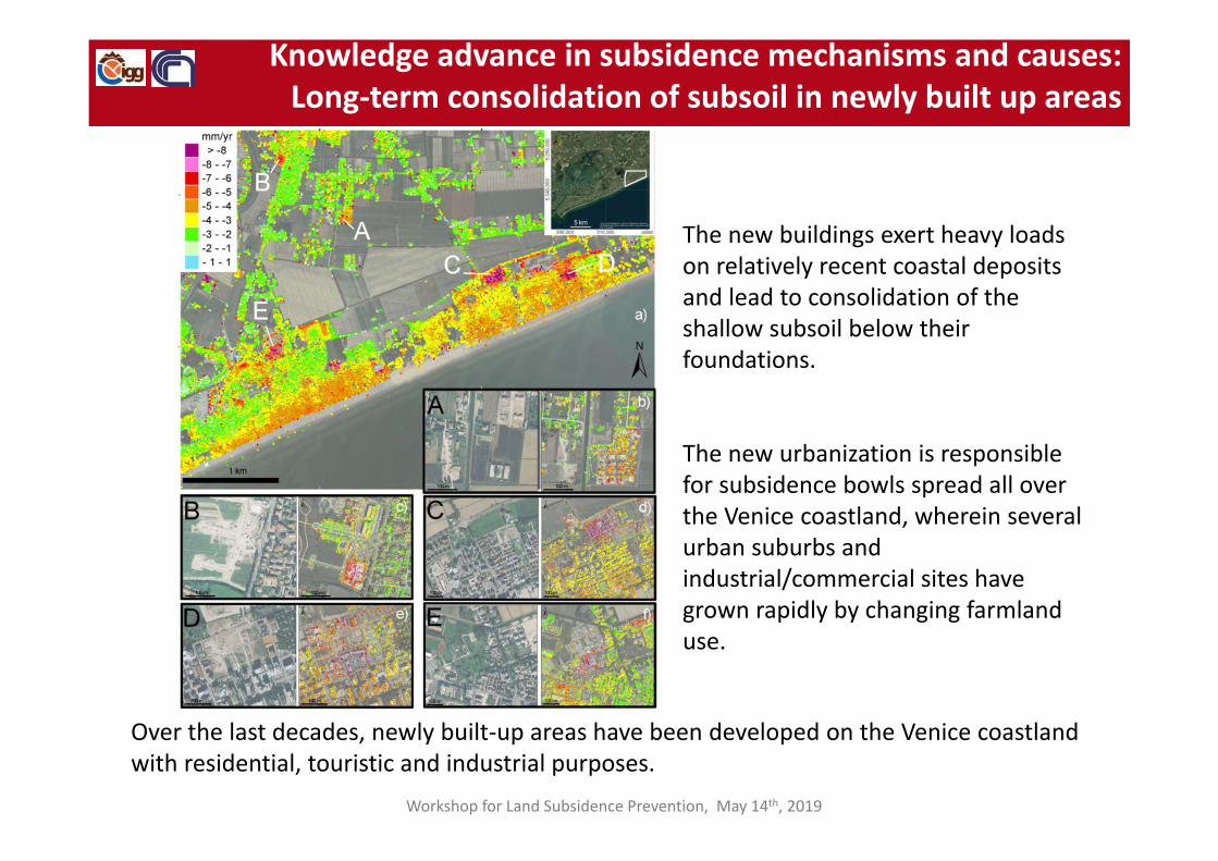
The new buildings exert heavy loads on relatively recent coastal deposits and lead to consolidation of the shallow subsoil below their foundations.
The new urbanization is responsible for subsidence bowls spread all over the Venice coastland, wherein several urban suburbs and industrial/commercial sites have grown rapidly by changing farmland use.
Over the last decades, newly built‐up areas have been developed on the Venice coastland with residential, touristic and industrial purposes.
Workshop for Land Subsidence Prevention, May 14th, 2019

Knowledge advance in subsidence mechanisms and causes:long‐term consolidation in the historical center
The high spatial resolution of the interferometric data provided a new picture of the subsidence of Venice and revealed that the sectors with higher sinking correspond to those of the last urbanization:• Stable sectors generally correspond with the city
development before 1500.• Secondary consolidation is still active in the
newer sectors.
Rates of ground vertical displacement (mm/year) at Venice
Workshop for Land Subsidence Prevention, May 14th, 2019
Sketch of the growth in area of Venice from 900 A.D. to present.
The city developed over ancient well‐consolidated sandy islands during the first millennium, and the following expansions were done by reclaiming and filling parts of the lagoon and channels.

Anthropogenic ground movements
Long‐term displacements (1992‐2010) by C‐band SAR sensors (ERS/ENVISAT):The 20 m pixel resolution and 35‐day revisiting time poorly capture and significantly smooth the short‐term anthropogenic subsidence (in VENICE). We can assume that the 1992‐2010 mean velocities are reasonably the picture of the present natural subsidence
Short‐term displacements (2008) by X‐band SAR sensor (TerraSAR‐X):The X‐band sensor with 3 m pixel resolution and 10‐day revisiting time detects rapid movements, which in VENICE are primarily ascribed to the anthropogenic causes superposed to the natural background
The quantification of the ground displacements is obtained by removing the long‐term interpolated map (1992‐2010) from the short‐term interpolated solution (2008)
The combined use of interferometric products obtained by sensors with different bandwidth extends the capability of the SAR‐based Interferometry
Knowledge advance in subsidence mechanisms and causes:ground movements induced by anthopogenic activities
1992‐2010: C‐band 2008: X‐band
ENVISAT TerraSAR‐X
Workshop for Land Subsidence Prevention, May 14th, 2019

Anthropogenic ground movements (2008)
Waves induced by the boat and ship traffic on the embankment walls and sidewalk next to the canals.
Restoration works for the conservation of the historical palaces and the embankment walls (e.g., new loads, consolidations, jet grouting, well‐points), dredging the canals, etc.
Advances in understanding land subsidence process: depth‐dependent mechanisms
During the last two decades, many interventions have been carried out for safeguardingthe city and some of them likely produced short‐term ground displacements
Workshop for Land Subsidence Prevention, May 14th, 2019
Knowledge advance in subsidence mechanisms and causes:ground movements induced by anthopogenic activities

The city of Venice and its surrounding lagoon is presently one of the sites most sensitive to land subsidence worldwide. Even a few mm loss of ground elevations with respect to the mean sea level can significantly change the natural lagoon environments and threaten the city’s survival.
The monitoring of land subsidence in the Venice area began in the 1960s using spirit leveling and over the last decades has been significantly improved using space‐borne observation techniques based on synthetic aperture radar (SAR) interferometry. The subsidence monitoring network of the Venice coastland progressively increased from a few hundreds of leveling benchmarks to more than one million of SAR reflectors. This reduced the use of in‐situ measurements to calibrate and validate interferometric products.
The increased spatial coverage allowed:‐ Investigating the subsidence process in areas never been studied before;‐ A much wider and accurate quantification (space/time) of ground dynamics;‐ An improvement of the knowledge on the various factors driving land subsidence.
Conclusive Remarks
Workshop for Land Subsidence Prevention, May 14th, 2019

Driving factors known in the pastNatural components• Tectonics: deformation of the bedrock• Compaction of the Plio‐Pleistocene
deposits: about 1,500 m thick of sandy and silty‐clayey layers of alluvial and marine origin
Anthropogenic activities:• Subsurface fluid exploitations: mainly
groundwater
Driving factors that came out recently Natural components• Differential compaction because of
the variability of the deep subsoil architecture at regional scale.
• Compaction of the shallow subsoil: in particular the Holocene sediments, mostly lagoon muds and unconsolidated clay and silts
Anthropogenic activities:• Hydraulic land reclamations (ancient
lagoon and wetland sectors) leads to organic soil oxidation and saltwater intrusion
• Newly built‐up areas• Restoration works
Conclusive Remarks
Workshop for Land Subsidence Prevention, May 14th, 2019

The strategies for prevention and mitigation of the effects of the land subsidence in the Venice coastlands are based on technical and governance aspects.
• Set up of a proper systems for monitoring land subsidence integrating satellite‐and ground‐ based methodologies such as multi‐band interferometry, continuous CGP stations, differential GPS measures and spirit levelling;
• Implementation of pilot projects for improving knowledge of the process and developing updated monitoring methods;
• analysis of the effects and identification of stakeholder requirements;• a continuous knowledge improvement of the subsoil setting and architecture.• proposing best practices, procedures and guidelines such as:
the regulation of groundwater exploitations combined with the monitoring of the groundwater levels;
the proper management of the hydraulic land reclamation of low‐lying farmlands reducing the oxidation of organic solid;
appropriate irrigation practices by watercourses and precision method;
Conclusive Remarks
Workshop for Land Subsidence Prevention, May 14th, 2019

Among the mitigation measures to counteract the land subsidence effects there are:
• Ground floor rising of the historical centers;
• Beach nourishments;
• Reconstruction of salt marshes;
• The construction of the mobile gates at the lagoon inlets;
• Continuous improving of the pumping stations for guarantee the drainage of the
low‐lying coastal sectors;
• Freshwater injection in shallow aquifers contaminated by saltwater intrusion
because of the ground elevation loss in low‐lying farmlands;
• The assessment of vulnerability to land subsidence.
Conclusive Remarks
Workshop for Land Subsidence Prevention, May 14th, 2019

Thank you


![Study of land subsidence around the city of Shirazscientiairanica.sharif.edu/article_2167_b3bb54f3fcf13e2c...tectonic subsidence, and etc. [2]. Land subsidence, as a serious crisis,](https://img.pdfslide.net/doc/110x75/5f81603bf7f7323e190f6f7c/study-of-land-subsidence-around-the-city-of-s-tectonic-subsidence-and-etc.jpg)