Embed Size (px)
Citation preview

Document of
The World Bank
FOR OFFICIAL USE ONLY
Report No. 6904-BDa
STAFF APPRAISAL REPORT
BANGLADESH
SECOND SMALL SCALE FLOOD CONTROL, DRAINAGE AND IRRIGATION PROJECT
SUPPLEMENTARY VOLUME
December 22, 1987
Agriculture Operations DivisionCountry Department IAsia Regional Office
This document has a restried distibution and may be ue by repileus only in the performance oftheir official duties. Its contents may not otherwise be d osed out World Bank auwrizaion.
Pub
lic D
iscl
osur
e A
utho
rized
Pub
lic D
iscl
osur
e A
utho
rized
Pub
lic D
iscl
osur
e A
utho
rized
Pub
lic D
iscl
osur
e A
utho
rized
Pub
lic D
iscl
osur
e A
utho
rized
Pub
lic D
iscl
osur
e A
utho
rized
Pub
lic D
iscl
osur
e A
utho
rized
Pub
lic D
iscl
osur
e A
utho
rized

CURRENCY AND EQUIVALENT UNITS
Bangladesh Taka * 100 paisaUS$1 (October 1987) Tk 31.0 (Official Rate)
Tk 33.0 (Free Market WageEarner's Rate)
WEIGHTS AND MEASURES
1 meter (a) = 3.28 feet (ft)1 kilometer (km) 0.62 mile (mi)1 heceare (ha) 2.47 acres (ac)
ABBREVIATIONS
AIT - Asian Institute of TechnologyBADC - Bangladesh Agricultural Development CorporationBARC - Bangladesh Agricultural Research CouncilBRDB - Bangladesh Rural Development BoardBWDB - Bangladesh Water Development Boardb. - When preceding a crop means broadcastCIDA - Canadian International Development AgencyCTU - Canadian Technical UnitDAE - Department of Agricultural ExtensionDTI - Deep TubewellFA - Force AccountFCD - Flood Control and DrainageFRW - Flood Rehabilitation WorksFFW - Food-For-Work ProgrammeCOB - Government of BangladeshRIV - Hand TubewellHYV - High Yielding VarietiesICB - International Competitive BiddingIDA International Development AssociationLCB - Local Competitive BiddingLLP - Low Lift PumpM&E - Monitoring and EvaluationMOA - Ministry of Agriculture and ForestsmOF - Ministry of Fisheries and LivestockMOI - Ministry of Irrigation, Water Development and Flood ControlMLG - Ministry of Local Covernment, Rural Development and CooperativesMPO - Master Planning OrganizationNWCL - Northwest Hydraulic Consultants, Ltd.NWP - National Water PlanO&M - Operation and MaintenancePIU - Project Implementation UnitPPAR - Project Performance Audit ReportPP - Project ProformaSSDFC - Small Scale Drainage and Flood ControlSSFCDI - Small Scale Flood Control, Drainage and IrrigationSTW - Shallow Tubewellt. - When preceding a crop means transplantedWFP - World Food Programme

FOR O CMIL USE ONLY
GLOSSARY
Man - BRice planted before or during the monsoon and harvested inNovember or December.
Aus - Rice planted during February or March and harvested during Juneor July.
Boro - Rice transplanted in December or January and harvested in Aprilor May.
Iharif - Surer cropping season (May through October).
labi - Winter cropping seaon (October through May).
Notisoon - Period of rains starting in June and ending in October.
Beel Low-lying area subject to flooding by rain or river water.
Khal - Natural channel
District - Administrative unit in the charge of a Deputy Commissionercomprising a number of Upazilas.
Upasila - Smallest administrative unit of local government
FISCAL YEAR
July 1 - June 30
This document hs a restricted distribution and may be used by reciplents only in the performanceof their offlcial duties. Its contents may not otherwise be disclosed without World Bank authorization.

\i~-
C§?,\
BANGLADESH
SECOND SMALL SCALE FLOOD CONTROL, DRAINAGE AND IRRIGATION PROJECT
Table of Contents
ANNEXES
1. Guidelines for Preparation of Subprojects (SSFCDI Works)
2. Project Management System - Terms of Reference (SSFCDI Works)Table 1 : Staffing Schedule
3. Consultancy Services During Implementation - Terms of Reference (FRW)
4. Mathematical Modelling Studies of River Sections Protected by theBrahmaputra Right Embankment - Guidelines for Preparation of Terms ofReference
5. Summary Statement Cost (FRW)
6. List of Identified Schemes (FRW)

li�l
I-i�'S'.
l\v\

ANNEX 1Page 1
BANGLADESH
SECOND SMALL SCALE FLOOD CONTROL, DRAINAGE AND IRRIGATION PROJECT
Guidelines for Preparation of Subprojects (SSFCDI Works)
I. Introduction
1.01 Proforma have been designed to assist in assembling technical infor-mation required for the preparation of identification and feasibility:eports. Different project components, consisting of fully planned sub-projects and appurtenant structures subprojects (including rehabilitation andrepair works) would have different standards for acceptance. Separateproforma have been designed for these components.
1.02 The procedure to be adopted is given below:
(a) Identification reports for all subprojects prepared by BWDB fielddivisions, as described in proforma detailed below and discussed withthe Superintending Engineer of the Circle, would be submitted to thePIU for review. PIU would be assisted by CTU and the FFW Unit in theFlood Control Cell of BWDB.
(b) Identification reports on proposed rehabilitation and repair workswould have sufficient data to enable PIU to present these subprojectsat the five-party meeting to be scheduled for September of each year(Proforma One). At this meeting, decisions would be taken to proceedwith detailed engineering.
(c) Identification reports on proposed appurtenant structures subprojectswould have sufficient data to enable PIU to prepare a feasibilityreport (Proforma Two) and present it to the five-party meeting ofSeptember, recommending that it proceed with the detailed engineeringof the subprojects.
(d) Identification reports on proposed fully planned subprojects wouldhave sufficient data to enable PIU to recommend that the subprojectsadvance to the feasibility phase (Proforma Three).

-2-ANX 1Page 2
(e) PIU would also draw up work programs, technical specifications, andtender documents, as necessary, for conducting topographical surveysand geotechnical investigations to required standards (feasibilitylevel, detailed engineering, etc.).
II. Proforma One
Identification Report for all subprojects
2.01 Name of Subproject and Location. District and Upazila, BWDB Circleand Division, and brief description of access.
2.02 Type. Drainage, flood control, irrigation, and/or salinity control.
2.03 Food-For-Work (this information is not needed for repair andrehabilitation works).
(a) Type of work: viz re-excavation of khals, new or resectioned embank-ments, access roads, etc.
(b) Quantities in cu meters of earthwork and metric tons of wheatrequired.
(c) Year and WFP reference number.
gd) Brief comment on the availability of a comprehensive plan anddetailed designs. Was the work undertaken on a phased program? Ifso, give details and progress. If not completed, give the remainingbalance and program of works.
2.04 History, Present Status, and Problems
(a) Describe history of the subproject with regard to its planning,design, construction, and operation. Are feasibility reports avail-able? Is the subproject a part of a larger project or polderdevelopment? If so, what are the reasons for not taking up thedevelopment of the larger project or polder?
(b) For rehabilitation and repair works: give details of works, cause ofdamage (inappropriate design, ineffective operation and/or delayedmaintenance, natural disaster, etc.), preliminary design sketches,cost, and implementation period.
(c) For appurtenant structures: indicate whether there are additionalrequirements to resolve technical problems such as rapid draining oflow pockets, inadequate wateoway provided, structure to be located ina gap in the embankment, access impeded as a result of FFW, etc.
(d) For fully planned schemes: describe existing situation. If scheme ispartly completed, provide sufficient information on completed worksand prepare a preliminary estimate of works remaining to be done andcost of such work. Also, provide sketch plans of existing works.

-3- ANNEX 1Page 3
Describe briefly the problems constraining agricultural developmentunder pre-project conditions.
2.05 Proposal. Describe overall plans, details of proposed structureswith sketches, cost estimate, and implementation period.
2.06 Land Acquisition. Give preliminary estimate of area and cost of landneeded. Has land already been acquired? If not, describe the present statusand owner's response to acquisition.
2.07 Environmental Impact
Item Improved No Change Reduced Not Applicable
Crop ProductionFish ProductionShrimp ProductionLand TransportationWater TransportationEffect on AdjacentAreas
Drainage System WithinProject Area
Sedimentation WithinProject Area
Other
2.08 Selection Criteria
Responsibilityfor Determining
For All Subprojects Conformity
(a) Subject to an up-to-date appraisal PIUincluding an evaluation of hydrology,soils, crops, fisheries, transportrequirements, and impact on adjacentareas.
(b) For all subprojects, except repair and PIUrehabilitation works, ERR should be atleast 15% on project investments(excluding sunk costs).
(c) Discussions with beneficiaries, Fieldlocal authorities, and GOB Divisionstechnical staff.
(d) For irrigation schemes: beneficiaries Fieldwillingness to execute command area Divisionsdevelopment below eight ha turnouts.

-4_ ANNEX 1Page 4
(e) Beneficiaries' willingness to con- Fieldtribute towards O&M upon subproject Divisionscompletion.
For Appurtenant Structures Subprojects (including repair andrehabilitation works)
(f) Cost not to exceed US$ 375 per ha. FieldDivisions
(g) Original design prepared by BWDB and earth- Fieldworks constructed under FFW program or Divisionsprogrammed to be done (not neededfor repair and rehabilitation works).
(h) Base cost not to exceed US$ 400,000. FieldDivisions
(i) To be completed within two construction Fieldseasons# Divisions
For Fully Planned Schemes
Cj) For flood control and drainage schemes: Fieldcost not to exceed US$ 500 per ha. Divisions
(k) For irrigation schemes: cost not to Fieldexceed US$ 2,000 per ha. Divisions
(l) For flood control, drainage and Fieldirrigation schemes: cost not Divisionsto exceed US$ 2,500 per ha.
(m) For flo'i control and drainage Fieldschemes: gross protected area Divisionsnot to exceed 7,500 ha.
(n) For irrigation schemes: net area Fieldnot to exceed 1,000 ha. Divisions
(o) Base cost not to exceed US$ 1.5 M. FieldDivisions
(p) To be completed within three Fieldconstruction seasons. Divisions
Note: For appurtenant structures schemes (excluding repair and rehabili-tation works) and fully planned schemes, conformity to the criteriashould be verified by PIU after detailed engineering and feasibilitystudies, respectively, have been completed.

-5- ANNEX 1Page 5
Agricultural Data (not needed for repair and rehabilitation works)
2.09 Soils. Indicate which of the following major surface soil texturalclasses are predominant: sand, sandy loam, loam, clay loam, silty clay, clay.Attach soil maps, if available.
2.10 Land Types. Indicate the percentages of each of the following landtypes within the project area, before and aftee improvements.
X Before x After
(a) Highland: flooding up to 0.3 meters(b) Medium Highland: flooding 0.3 to 0.9 meters(c) Medium Lowland: flooding 0.9 to 1.8 meters(d) Lowland: flooded deeper than 1.8 meters
Total 100 100
2.11 Cropping Patterns. Describe the cropping pattern on the above fourr
land types under pre-project and post-project conditions. Crops should bespecified, viz8 aus, b. aman (local and deep flooded varieties), t. aman(local, HYV, LIV), boro (local without irrigation), irrigated boro (LIV,H'iV), wheat, jute, and other rabi crops. Data to be given in a tabulatedform. Give reasons for changes in cropping pattern, yields, areas, etc. Inaddition, estimate shrimp and fish production before and after the preject.
2.12 Plan of Operation. If proposals are for improvements or rehabilita-tion, describe briefly the existing plan of operation and the condition ofthe existing works. The plan of operation should include information onGOB's and beneficiaries' responsibilities, budget and programme of work,effectiveness of O&M (viz: gate operation, maintenance of embankments, anddrainage canals, rotational system for irrigation projects, etc.). Arebeneficiaries willing to operate and maintain project works? To what extent?
Basic Engineering Data (not needed for repair and rehabilitation works)
2.13 Flood Data. Describe the average annual flood conditions in thesubproject area.
Flood Depth Elevation (M) Incremental Cumulative Z of Total(Meters) From To Area Area Area
-------- Hectare--------
Not Flooded
0- 0.3 M0.3- 0.9 M0.9- 1.8 MAbove 1.8 M

-6- ANNEX 1
Page 6
2.14 Work Load of the DivisionProject Completion Financing
Name of Project Scope of Work Cost % -Agency
III. Proforma Two
Feasibility Study for Apgurtenant Structur9s Subprojects (excluding repairand rehabilitation works)
3.01 Objective. The studies are conducted to determine tho economic rateof return (ERR) in order to determine whether or not the subproject goes intothe detailed engineering phase.
3.02 Summar . This para would summarize the findings of the feasibilityreport, lincluding scheme area, number of farm families that would benefit,anual foodgrain production and its value at economic farmgate prices, annLalincremental agricultural employment in man-days, impact on alleviation ofpoverty, and the ERR.
3.03 Engineering Analysis, Preliminary Designs, and Outline Drawings.These are needed for all works to be financed under the project andearthworks to be done on FFW and should include the following:
(a) Hydrological Analysis. Determination of the cumulative effect ofrainfall within the empoldered area taking into consideration thesimultaneous rise of water levels at the outfall rivers. An analysisof the empoldered area for varying options on hydraulic capacitywould indicate the optimum hydraulic capacity to discharge peak floodflows in the quickest possible time with a minimum submerged area.The drainage rate for use in the design of drainage canals andembankments would also be obtained from this analysis. The polderanalysis would include meteorological and river stage data. Therelated tables for the polder analysis and the hydraulic designparameters would be used for the preliminary designs.
(b) Preliminary Designs and Outline Drawings. As far as possible, BWDBtype-designs should be followed. Sketch plans of structures, embank-ments and drainage canals should be included.
3.04 Capital Cost Estimates Unit Quantity Cost
Preconstruction Activities
1. Land Acquisition2. Investigations and Surveys

-7-ANNEX 1Page 7
Capital Cost Estimates Unit Quantity Cost
Civil Works
3. Hydraulic Structures4. Access Infrastructure5. Earthwork on FFW
Subtotal Base Cost
Overheads
6. Project OH, 8% of Subtotal7. HQ OH, 2.5% of Subtotal Above
Total Base Cost
8. Physical Contingencies10% of Base Cost
Total Project CostCost per ha = Benefitted Area
Note: Access infrastructure to be provided should conform to the selectioncriteria. Land acquisition should be supported by a sketch plan.Proposals for surveys and investigations should include details onlong. sections in km, cross sections in nos., site surveys in nos.and average area, and rates for each item. Benefitted areas for floodcontrol and drainage subprojects should refer to gross areas and forirrigation subprojects to net areas.
3.05 Annual Operations and Maintenance Cost Estimate. Calculate in thetable below the annual O&M costs, as a percentage of capital cost.
X of CapitalDescription Capital Cost Cost Amount
Civil Works 1.5Field Overheads LSHQ Overheads LSContingencies, 10%of Items AboveTotal Annual O&M Cost

-8- ANNEX 1
Page 8
3.06 Crop Production and Values
Pre-Project Condition Post-Project Conditionprop Area Yield Production Value Area Yield Production Value
ha mt/ha -mt Tk ha mt/ha mt Tk
Total
Cropping Total Crop Area X 100 Cropping Total Crop Area X 100Intensity Net Benefitted Area Intensity = Net Benefitted Area
Changes in Cropping Intensity %Changes in Production Value %
3.07 Direct Crop Production Cost--Pre-Project Condition
Draft Total TotalLabor/ha Power/ha Seed/ha Fert/ Pest/ Irrig Crop Prod.
o2 DaysC D Cost Cost K Cost ha ha ha Area Cost
3.08 Direct Crop Production Cost--Post-Project Condition
Draft Total TotalLabor/ha Power/ha Seed/ha Fert/ Pest/ Irrig Crop Prod.
Crop Days Cost Days Cost X Cost ha ha ha Area Cost
Notes for Paras 3.07 and 3.08
(a) Analysis is based on a typical farm of 1 ha (2.5 ac).(b) Economic prices to be used for seed, fertilizer, and insecticides.
These should be based on international prices.(c) Irrigation cost would include water charges by COB and charges for
water distribution within command area of LLP, gravity turnouts,STW, and DTW.
(d) Cost per ha for fertilizer and pest control should be supported bydetails on fertilizer type, quantity, rate, and cost for each typeand crop.
(e) Land rentals, interest on short-term loans, and local land taxescannot be easily obtained and are highly variable between farms inthe same subproject. As such, these should be excluded fromproduction costs.

-9- ANNEX 1Page 9
3.09 Annual Benefit. Calculate the annual benefit to be derived in thesubproject area.
Pre-Project Post-ProjectItem Value Value Increment
1. Gross Annual Production Value(from para 3.06)
2. Annual Crop Production Costs(from Paras 3.07 and 3.08)
3. Net Annual Benefit (Item 1less Item 2)
Post-Project Value-Pre-Project Value X 100X Increase in Net Annual Benefit= Pre-Project Value
3.10 Determination of Economic Rate of Return. Complete the undermen-tioned table and, using a discount rate of 15% per annum, complete the lastline of the table. A positive figure at the end of the life of projectestimated at 30 years after completion of project works would indicate thatthe project is ecosuomically viable.
Economic Benefits
Years1 2 3 4 5 6 7 8-30
1. Production Benefits With Project2. On-farm Cost With Project3. Gross Benefit With Project tl)-(2)4. Production Benefit Without Project5. On-farn. Cost Without Project6. Gross Benefit Without Project (4)-C5)7. Project Benefit (3)-(6)8. Investment Costs9. O&M Costs10. Total Project Cost (8)+(9)11. Net Project Benefit (7)-(10)12. Net Benefit Discounted at 15%
Notes
(a) Life of the project is taken as 30 years, including 3 years for comple-tion of project works. The project is expected to attain maturity at 5years after completion.
(b) Future farmgate prices for internationally traded commodities should bederived from current IBRD price projections in constant currency valueswith appropriate adjustment for freight, handling, processing, etc.Non-traded cost and benefit items should be adjusted by a Standard Con-version Factor (SCF) of 0.80 to bring them to the same price basis astraded ones. Official exchange rates for the Taka should be used.

-10- ANNEX 1
Page 10
(c) Shadow wage rates for labour should be the average prevailing ratesweighted by the approximate length cf season over which they prevail.This rate should be discounted by the factor 0.75 to revalue it in borderTaka.
(d) Investment and O&M costs should be exclusive of taxes, duties and pricecontingencies. Local costs should be expressed in bordet Taka afterapplying SCF of 0.8. Capital cost of minor irrigation equipment shouldnot be included, but its O&M cost would be part of the farm budget. Landacquisition costs for the economic analysis would be the value of produc-tion foregone due to withdrawal of land from agricultural use and shouldnot be included separately in the analysis.
IV. Proforma Three
Feasibility Study for Fully Planned Subprojects
4.01 Contents
4.02 Names of Scheme, District, Upazila, Unions, and BWDB Field Divisions
4.03 Introduction. Briefly describe main project history and concept.
4.04 Summary and Conclusion. Briefly the following should be discussed:
(a) Subproject area: benefitted area, population, land tenure, croppingpatterns, and foodgrain production.
(b) Subproject works: proposed infrastructure.fc) Benefits: cropping patterns and cropping intensities, production,
land reclamation, access facilities, employment, and environmentalchanges.
(d) Estimated cost.Ce) Economic justification.(f) Conclusion and Recommendation.
4.05 Compliance with Selection Criteria. In a tabulated statementdescribe conformity or otherwise.
4.06 Existing Conditions and Available Data. This should include:
(a) Hydrometeorology, i.e climate, rainfall and hydrology.(b) Flooding, drainage congestion, salinity, irrigation development,
navigation and fisheries.(c) Infrastructure should cover flood control, irrigation faciliEies,
communication and energy.(d) Socioeconomic situation should cover population, number of
households, population density, average family size, estimated labourforce, land tenure, and size of holdings.
(e) Agriculture, livestock, and agricultural inputs.(f) Soils.(g) Supporting institutions: agricultural extension, cooperatives,
credit, farm input and marketing services, etc.

-11- ANNU Page 11
4.07 Hydrological Analysis should include:
(a) Meteorological, stream flow, and salinity data.(b) Depth duration analysis.(c) Crop water requirements if irrigation development is included.(d) Design drainage rate.(e) Flood levels for return periods of 10 and 20 years.(f) Flood routing for a 10- day design storm through regulators of
varying number of vents to determine the optimum hydraulic capacityfor a minimum submerged area.
(g) From the above analysis, indicate the conclusions arrived at inrespect of design level of embankments, ventage and sill level ofregulators, and drainage canal section.
(h) Tables relevant to paras (a) through (f) above.
4.08 Engineering should include details on:
(a) Land acquisition.(b) Surveys and investigations.(c) Embankments.(d) Regulators and other hydraulic structures.(e) Access facilities.(f) Irrigation development.(g) Navigation.(h) Plan of cperation for the O&M phase.(i) Quantities, cost estimates, and outline drawings.
4.09 Environmental Impact
4.10 Investment Schedule and Total Project Cost
4.11 Organization and Management
4.12 Agricultural Development. Give gross and net areas for depths offlooding 0 to 0.3 M, 0.3 to 0.9 M, 0.9 to 1.8 M, and over 1.8 N, designatedas Highland, Medium Highland, Medium Lowland and Lowland, respectively.Also, indicate cropping patterns, input use, yields, and irrigation require-ment.
4.13 Economic and Financial Analysis should include:
(a) Farm income and employment.(b) ERR and sensitivity analysis.(c) Tables as described in paras 3.04 through 3.09 of Proforma Two
relating to:- Pre-project and post-project economic cost per ha for labor,animal draft power, seeds, pesticides, fertilizers and irrigationin respect of the three main rice crops: aus, aman and boro.
- Pre-project and post-project per ha economic returns for main andby-products in respect of aus, aman and boro rice.
- Pre-project and post-project economic benefits and crop pro-duction costs for the areas cultivated during the three mainseasons. The table should also include the pre-project and

-12- ANNEX 1Page 12
post-project cropping intensities and the increments inrespect of cropping intensity, economic benefit, grain pro-duction, and production of other crops.Pre- and post-project farm budget analysis.
4.14 The methodology described in para 3.10 of Proforma Two should beadopted for the determination of the ERR.

-13- ANNEX 2
Page 1
BANGLADESH
SECOND SMALL SCALE FLOOD CONTROL, DRAINAGE AND IRRIGATION PROJECT
Project Management System (SSFCDI Works)
Terms of Reference
Introduction
1. The project management system to be adopted for the Second SSFCDIProject would be be similar to the system operating in the First SSDFCProject, Cr. 955-BD. The system would comprise a Project Implementation Unit(PIU) staffed by BWDB personnel and assisted by a Canadian Technical Unit(CTU) and a Design Circle (DC) staffed by BWDB design engineers. Objective,scope of services, activities, outputs, responsibilities, and staffingrequirements of PIU, CTU, and DC, together with job descriptions, requiredexperience, and qualifications of senior personnel of CTU, are describedbelow.
Objective and Scope of Services
2. The main objective of the project management system is to ensure thatthe project would be implemented in accordance with the agreed program,particularly that selected subprojects would conform to the agreed criteriaand would be constructed to acceptable standards. The management serviceswould be provided for the implementation of about 15 fully planned and about200 appurtenant structures subprojects and would include identification ofsubprojects, preparation of feasibility reports and detailed engineeringdocuments, monitoring during construction and preparation of plans of opera-tion for O&M of the subprojects.
Activities
3. Identification Phase. Screening of identification reports for allsubprojects, prepared by BWDB O&M divisions following the format of ProformaOne (Annex 1 of the Supplementary Volume), would include the following:
(a) a field reconnEissance of the subproject to check technical andsocioeconomic data and discuss the proposals with local Governmentstaff and beneficiaries;

-14- ANNEX 2Page 2
(b) study of topographical and hydrological conditions;
(c) study of suitability of flood control and drainage subprojects forempoldering and irrigation subprojects for dry season irrigation andwet season supplementary irrigation (possible effects on adjacentpolders, adequacy of dry season flows, and salinity conditions wouldalso be studied);
(d) study of existing road and navigation facilities;
(e) study of existing fisheries development;
(f) limitations imposed by ongoing and other proposed developmentprograms;
(g) preliminary hydrological and flood routing studies to determine thatsubproject has adequate basin storage to limit internal water levels;determination of design levels of embankments, capacity, and numbersof drainage structures; and assessment of irrigable command area (forirrigation subprojects only);
(h) preparation of a conceptual plan of development;
(i) preparation of preliminary designs, sketch plans, and cost estimates;
(j) assessment of completed and ongoing works under the FFW program andpreparation of preliminary proposals for additional works;
(k) assessment of present land use and landholdings;
(g) assessment of the likely benefits accruing to the subproject underimproved conditions;
(i) collection of relevant technical and socio-economic data for thepreparation of the plan of operation tor the O&M phase of the sub-project; and
(n) the preparation of a screening report on the group of subprojects tobe presented for discussion at the five-party review meeting to beheld in September of each year;
4. Feasibility Phase. Based on field visits and the identificationreports, the following activities would be undertaken for the fully plannedsubprojects (see Proforma Three of Annex 1 of the Supplementary Volume):
(a) comprehensive study of all technical alternatives (including sub-project boundaries) and a detailed review of all relevant factorsin order to maximize benefits and to support Government's decision toimplement the subproject;

-15- ANNEX 2
Page 3
(b) comprehensive review of the risks involved, including: siltation,salinity, adverse consequences inside the polder and/or on neighbor-ing areas, projects or rivers, and recommendation of necessaryremedial measures;
(c) assessment of the potential for irrigation in the subproject area onthe basis of availability of surface and groundwater and suitabilityof the soils for cultivation of irrigated crops; tidal effects shouldalso be considered, where applicable;
(d) assessment of any significant adverse effects of the proposed workson fishing, navigation, etc.;
(e) spot checks of the subprojects' critical features (elevation of beelsand spill channels; capacity of the outfall channels) and identifica-tion in the field of any possible problems, for example, concerningland acquisition, together with proposed solutions;
(f) study of the consequences -- positive or otherwise -- of reduction offlood depths for different parts of the subproject area, in relationto elevation and traditional cropping patterns; proposed remedialmeasures, as appropriate;
(g) preparation of an inventory of working irrigation equipment in thesubproject area and of the areas and crops serviced by the irrigationfacilities, together with proposals for increased irrigation;
(h) identification of constraints affecting the subproject, together withproposed remedial measures; the project works should not cause sig-nificant adverse effects on fishing or river transportation;
(i) hydrological analysis, determination of design levels and drainagecapacities, and preparation of feasibility level designs, plans andcost estimates;
(j) study of existing agricultural situation, including pre-project cropareas, inputs, yields and production, and recommendations forpost-project cropping pattern and use of inputs; estimation of futureyields and production, relating increases to use of improved cropvarieties, fertilizers, pesticides, etc. and to changes in crop,animal and fish husbandry practices, water supply and drainage;
(k) economic evaluation of alternative proposals for development of thesubproject area;
(1) a study of the institutions providing support services, includingagricultural extension, cooperatives, credit, and farm input andmarketing services;
(m) examination of the land tenure situation and assesment of thefarmers' willingness to adopt changes in cropping practices and toshare in the cost of operating and maintaining project facilities;

-16- ANNEX 2
Page 4
(n) examination of condition and operational features of existing floodcontrol, drainage, and irrigation facilities in the subproject area(the examination of the plan of operation should include presentresponsibilities of GOB and beneficiaries, budgets, staff resources,and water charges levied by GOB and/or beneficiary group leaders);and
(o) preparation of a programme for engineering surveys and geotechnicalinvestigations needed for the preparation of detailed engineeringdocuments.
5. The identification reports for appurtenant structures subprojects(see Proforma Two, Annex 1 of the Supplementary Volume) would provide ade-quate data for the activities listed below. However, further field visitsmay be required for major appurtenant structures subprojects. Feasibilityreports are not required for repair and rehabilitation works. The followingsubjects would be covered:
(a) engineering analysis, preparation of designs and outline drawings forthe structures, and design levels and profiles for embankments anddrainage canals to be constructed under F'W;
(b) preparation of cost estimates for civil works to be financed underthe project and FFW;
(c) agricultural and economic studies similar to those described underparas 4 (j) and (k), respectively;
(d) preparation of a programme for engineering surveys and geotechnicalinvestigations for structures, embankments and drainage canals; and
(e) preparation of a plan of operation for the subproject.
6. Detailed Engineering Phase. Activities for all subprojects, approvedfor implementation, would include:
(a) preparation of work specifications, quantities, and cost estimatesfor topographical surveys and geotechnical investigations;
(b) checking and finalizing of embankment alignments, location ofhydraulic structures, access roads and bridges, and drainage network;
(c) carrying out of detailed designs for the works listed under (b)above, preparation of detailed drawings suitable for construction,preparation of bills of quantities, cost estimates, and specifica-tions;
(d) preparation of a detailed engineering report for works to be doneunder FFW to a standard acceptable to the Flood Control Cell of BWDBand WFP; and

-17- ANNEX 2
Page 5
(e) preparation of a draft plan of operation, which would be updatedduring project implementation and included in the O&M manual to beprepared by BWDB O&M divisions.
7. Construction Phase. The activities related to monitoring of physicaland financial progress for all subprojects would include:
(a) preparation of work programs in consultation with BWDB O&M divisionsand based on decisions taken at the five-party review meeting of Mayeach year;
(b) preparation of a construction manual;
(c) regular field visits to work sites to ensure that works are executedto specifications and design and are progressing according to theagreed programs; specific activities would include:
i) preparation of detailed construction schedules, together withestimates on funding requirements for each subproject;
(ii) ensuring that foundation excavation is done according to excava-tion plans, concrete aggregates at site are of acceptable stand-ards, adequate numbers of dewatering equipment and concretemixers are available at site and are in good working condition,formwork is of good quality and fixed to lines in the approvedplans, preparation and tying of reinforcements conform to the barschedule and approved plans, finished concrete is adequatelycured, and gates and control arrangements are installed accordingto specifications;
(iii) ensuring that embaakment fill is placed to design profile andthat construction methods conform to standards laid down in theconstruction manual, with emphasis placed on adequate compactionutilizing local resources, viz. labour and tools;
(iv) monitoring of disbursements at field divisions and BWDB HQ;
(v) reviewing with executive engineers and other BWDB field staff allrelevant findings of field visits, including, for example, sug-gestions for improvements of construction quality and for speed-ing up disbursements;
(vi) preparation of concise monthly and detailed quarterly progressreports; and
(vii) attending review meeting with the Ministry, BWDB management, IDA,CIDA and WFP.
8. Operation and Maintenance. The activities described in the plan ofoperation would be followed for all subproject works during the implementa-tion phase (see guidelines given in paras 4.12 through 4.14 of the MainVolume). Specifically, services during the O&M phase of project implementa-tion would include:

-18- ANNEX 2Page 6
(a) preparation of work programs for all completed structures, sectionsof embankments and drainage canals;
(b) monitoring to ensure that required standards are maintairtd;
(c) discussions with BWDB field staff, local Government staff, andbeneficiaries to finalize arrangements for an appropriate system ofoperation after completion of the project implementation period; and
(d) assistance to BIDB executive engineers in finalizing the OM manual.
Outputs
9. The outputs of the project management system have been estimated onthe basis of requirements of the six appraised fully planned subprojects and53 appurtenant structures subprojects identified prior to appraisal and onprojections for the remaining nine fully planned and 147 appurtenant struc-tures subprojects. The outputs comprise:
Fully Planned Subprojects (Gross Benefitted Area: 50,000 ha)
(a) identification of about 20 subprojects;
(b) feasibility reports for 15 subprojects (in addition to the sixappraised subprojects);
(c) detailed designs and plans for about 225 km of embankment, 250 km ofdrainage canals, 42 major drainage regulators, 24 flushing sluices,six water-retaining structures, and 215 minor structures such as pipedrainage outlets, irrigation outlets, check structures, etc.;
Appurtenant Structures Subprojects (Gross Benefitted Area: 200,000 ha)
(d) about 200 identification and feasibility reports;
(e) detailed planning of the protected area and detailed design of thedrainage canals and embankments to be taken up under FFW (based onestimates for the fully planned subprojects and assuming that 50% ofthe earthworks under FFW have been completed, excavation of about1,500 km of drainage canals and resectioning of about 1,350 km ofembankments would be required);
(f) detailed designs and plans for about 145 major structures, 18 flush-ing sluices, 21 water-retaining structures, and 360 minor structures;
All Subprojects
(g) screening reports for presentation at review meetings and preparationof minutes of meetings;
(h) monthly and quarterly reports on financial and physical progress;

-19-ANNEX 2Page 7
(i) Zonstruction manual (before June 30, 1988);
(j) annual work programs;
(k) reports on field visits; and
(1) completion report for each subproject.
Responsibilities
10. Assignment of responsibilities for various activities would be asfollows:
Description of Services Responsibility
Coordination of project activities PIU
Disbursement of project funds PIU
Assistance in preparation of identificationreports for all subprojects CTU
Preparation of screening reports and minutes of PIU with CTUreview meeting Assistance
Inclusion of subprojects not fully conforming toagreed selection criteria HOI and IDA
Preparation of feasibility reports for allsubprojects CTU
Preparation of project proforma for fullyplanned subprojects PIU
Detailed designs for fully planned subprojects CTU
Detailed designs for appurtenant structures DCsubprojects, except repair and rehabilitationworks
Detailed designs for repair and rehabilitation CTUsubprojects
Approval of detailed designs and plans CZ Designs
Preparation of work programs PIU in Consultationwith BWDI OUW
Divisions
Preparation of bill of quantities, estimates, BSDB 01W Divisionsand tender documents
-20-ANNEX 2Page 8
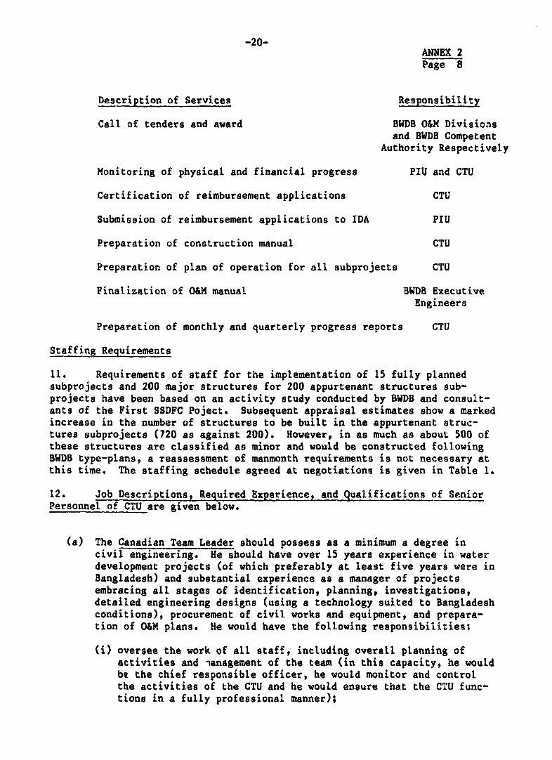
Description of Services Responsibility
Call of tenders and award BWDB O&M Divisicasand BWDB Competent
Authority Respectively
Monitoring of physical and financial progress PIU and CTU
Certification of reimbursement applications CTU
Submission of reimbursement applications to IDA PIU
Preparation of construction manual CTU
Preparation of plan of operation for all subprojects CTU
Finalization of O&M manual BWDB ExecutiveEngineers
Preparation of monthly and quarterly progress reports CTU
Staffing Requirements
11. Requirements of staff for the implementation of 15 fully plannedsubprojects and 200 major structures for 200 appurtenant structures sub-projects have been based on an activity study conducted by BWDB and consult-ants of the First SSDFC Poject. Subsequent appraisal estimates show a markedincrease in the number of structures to be built in the appurtenant struc-tures subprojects (720 as against 200). However, in as much as about 500 ofthese structures are classified as minor and would be constructed followingBWDB type-plans, a reassessment of manmonth requirements is not necessary atthis time. The staffing schedule agreed at negotiations is given in Table 1.
12. Job Descriptions, Required Experience, and Qualifications of SeniorPersonnel of CTU are given below.
(a) The Canadian Team Leader should possess as a minimum a degree incivil engineering. He should have over 15 years experience in waterdevelopment projects (of which preferably at least five years were inBangladesh) and substantial experience as a manager of projectsembracing all stages of identification, planning, investigations,detailed engineering designs (using a technology suited to Bangladeshconditions), procurement of civil works and equipment, and prepara-tion of O&M plans. He would have the following responsibilities:
(i) oversee the work of all staff, including overall planning ofactivities and nanagement of the team (in this capacity, he wouldbe the chief responsible officer, he would monitor and controlthe activities of the CTU and he would ensure that the CTU func-tions in a fully professional manner);

-21-ANNEX 2Page 9
(ii) establish detailed work plans, including programs and inputrequirements at all stages from screening and appraisal to con-struction and on-farm development;
tiii) subcontract for local specialist services, and select, hire, andsupervise local staff, including engineers, technicians,draftsmen, secretarial and clerical personnel, drivers, andlaborers;
(iv) advise BWDB on the use of IDA Credit funds allocated for theprocurement of construction equipment, materials and supplies;his tasks would include, but not necessarily be limited to, thefollowing:
- advise on calling of tenders and awarding of contracts forconstruction of water control structures;
- assist Government officials concerned with timely and orderlydelivery of goods to subproject sites;
- assist with accounting for all funds provided by IDA and CIDAfor procurement of equipment, materials, supplies, and laborin accordance with the terms of the IDA Credit agreement andthe CIDA Grant agreement;
(v) for IDA, prepare monthly and quarterly technical progressreports; for CIDA, prepare inception, monthly prugress and otherreports, as required, including a project completion report;assist with and advise on the preparation of technical andevaluation reports;
(vi) verify the Quarterly Financial Reports prepared by the PIU andsubmit observations, as required;
(vii) coordinate, integrate, and monitor all specialist inputs;
(viii) liaise directly with BWDB, IDA and CIDA as required; in thisregard, he would keep all parties informed of any problems andrecommend solutions;
(ix) assist and advise on planning and execution of the transfer-of-knowledge program;
(x) monitor procedures, progress, prublems and plans concerning otherwater resource development activities and advise the ProjectDirector on those which may impact on the project;
(xi) advise on all aspects of construction management, includingassistance to establish procedures for effective monitoring ofearthwork constructions in WFP-assisted subprojects;

-22-ANNEX 2Page 10
(xii) ensure that BWDB's requirements for technical support andguidance are fully met, within budget limitations, by the con-sultant's team;
(xiii) prepare an annual program for field inspection for the Implemen-tation Unit, including BWDB and consultants staff; and
(xiv) initiate a program for organizing meetings with local bodies andpublic representatives for operation and maintenance of completedschemes.
(b) The Canadian Civil/Construction Engineer should possess as a minimuma degree in civil engineering with over 15 years experience, of whichat least ten years should be in the construction of civil works inwater resources projects, preferably under conditions similar tothose in Bangladesh. Under the direction of the Team Leader, hewould have the following responsibilities:
fi) coordinate construction monitoring activities and related report-ing, organize and introduce operation and maintenance programs,coordinate the Fibre Reinforced Plastic Program under the CIDAsupported research program; and assist PIU with developing andmonitoring of a management reporting system;
(ii) prepare the construction manual;
(iii) participate in planning the construction program;
(iv) coordinate all construction monitoring activities with BWDB fieldengineers and PIU;
(v) provide expertise on construction methods, quality control,scheduling, and management;
(vi) develop and maintain standard construction progress and qualitycontrol formats;
(vii) supervise the collection and reporting of construction informa-tion (field trip reports);
(viii) oversee an expanded material testing program for sand bricks andconcrete;
(ix) make recommendations for modification of structures or construc-tion methodology, as required;
(x) visit construction sites, specifically those with special con-struction problems and recommend solutions to observed problems;
(xi) participate in the transfer-of-knowledge program;
(xii) coordinate all reporting activities;

-23- ANNEX 2
Page 11
(xiii) for the purpose of documenting construction records, developstandard office procedures for the compilation and storage of allphotographs, maps, engineering drawings, reports, books andoffice correspondence;
(xiv) review, assist, and advise, as required, on:
- work authorizations,- estimates,- indents,- tender documents and comparative statements,- work orders;
(xv) prepare drafts of various sections of the quarterly and monthlyreports, including progress, construction monitoring, specialproblems, etc., as required;
(xvi) supervise and instruct staff in computer applications for con-struction monitoring;
(xvii) prepare projections of divisional fund requirements and monitorfund flow from donors to field divisions;
(xviii) assist and guide preparation of cost studies for alternativedesigns and construction methods to establish improved solutions;and
(xix) assist in the preparation of operation and maintenance proceduresand manuals.
(c) The Canadian Planning Engineer should possess as a minimum a degreein c.vil engineering with ten years experience in water resourcesplanning of projects preferably under similar hydrological andtopographical conditions as those existing in Bangladesh. Under thedirection of the Team Leader, he would:
(i) review all previous studies and relevant technical data onirrigation, drainage and flooding;
(ii) study the management and regulation of small drainage catchmentsso as to mitigate flooding in the lower areas;
(iii) examine the availability of water in the rivers for multiplecropping in each subproject;
(iv) assess the primary drainage needs and establisih drainage designcriteria for control structures;
(v) examine the inundation levels, frequency and extent of damageswithin the subproject area,9 and review the adequacy of maindrainage facilities;

-24- ANNEX 2
Page 12
(vi) study historic floodings, including their frequencies, and reviewthe adequacy of flood control measures;
(vii) determine water supply availability (both surface andgroundwater) for irrigation, study the soils and topography ofthe area to be commanded, and review existing and proposed crop-ping patterns;
(viii) prepare layouts of irrigation and drainage facilities for aquantitative estimate;
(ix) prepare construction schedules with due attention tolabor-intensive methods;
(x) explore the engineering aspects of alternative proposals fordevelopment, such as heights and alignments of embankments andvarious types of irrigation systems, taking into accountbenefits, investment costs, operation and maintenance require-ments, land acquisition, and institutional arrangements involved;
(xi) review and finalize, together with the design engineers, thelocation for installation of major water control structures ineach subproject area;
(xii) develop feasibility-level engineering designs and quantity cal-culations of sluices, irrigation and drainage systems, includingaccess roads, together with detailed sample layouts of on-farmfacilities taking into account right-of-way, constructionmethods, and arrangements for implementation;
(xiii) prepare cost estimates of the subproject works, including opera-tion and maintenance, with a breakdown of foreign exchange andlocal currency components;
(xiv) prepare construction and disbursement schedules, together withdetailed implementation plans for the proposed subproject; andestimate manpower requirements for implementation, operation, andmaintenance.
(d) The Canadian Design Engineer should possess as a minimum a degree incivil engineering with at least ten years experience in detailedengineering designs, preparation of tender documents and assessmentof equipment, materials, and manpower requirements. Experiencegaintd under conditions similar to those in Bangladesh would bepreferred. Under the direction of the Team Leader, he would:
(i) check and finalize locations of hydraulic structures, pump sta-tions, etc.;
(ii) prepare layouts of embankments, hydraulic structures, etc.;

-25-ANNEX 2Page 13
(iii) establish the civil engineering criteria with due attention toappropriate technology, taking into account prevailing conditionsin Bangladesh;
(iv) prepare detailed drawings of each structure, including barschedules (regulators, flushing sluices, check structures,bridges, etc.);
(v) prepare detailed engineering reports including:- technical justification;- recommendations for complementary surveys if needed; and- review of potential improvement of irrigation facilities; and
(vi) prepare bills of quantiti3s, schedules of rates, cost estimatesand contract specifications.
(e) Responsibilities and duties of local professional staff would beworked out in detail by the Canadian Team Leader in close consult-ation with the Bangladeshi Senior Water Resources Engineer. Requiredqualifications and experience of the local professionals are listedbelow.
(i) The Senior Water Resources Engineer would be a civil/irrigationengineer with a degree in civil engineering from a recognizeduniversity and with over 20 years experience in the field ofirrigation engineering. He would have experience in the manage-ment of a multi-disciplinary team responsible for working oninvestigation and planning of drainage, flood control and irriga-tion projects. In addition, he should be fully conversant withthe operation and maintenance aspects of completed projects.
(ii) The Planning Engineer would be a civil engineer with a degree incivil engineering, preferably with a Master's degree in waterresources. He would have over 15 years experience in the inves-tigation and planning of drainage, flood control, and irrigationschemes.
(iii) The Design Engineer would be a civil engineer with a degree incivil engineering. He would have over 15 years experience ini-tially in the construction field and over 10 years at the designsoffice with responsibility for detailed engineering investiga-tions, preparation of designs, specifications, tender documents,and evaluation of bids.
(iv) The Agro-Economist would possess a degree in agriculturaleconomics and would have over 10 years experience in this fieldof which a minimum of three years were spent as the lead memberin economics in a multi-disciplinary team conducting feasibilitystudies in the agricultural sector, preferably in drainage, floodcontrol, and irrigation projects.

-26-ANNEX 2Page 14
(v) The Agronowiist would possess a degree in agriculture, specializ-ing in irrigated agriculture. He would have a minimum of 15years experience, of which at least two years were spent inconducting feasibility studies of agricultural projects.
(vi) The Project Engineer would possess a degree in civil engineeringwith over 15 years experience in civil engineering works in waterdevelopment projects.

1 27- ANNEX 2
Table 1
BANGLADESH
SECOND SMALL SCALE FLOOD CONTROL, DRAINAGE AND IRRIGATION PROJECT
Staffing Schedule(Man Months)
CTUDesign
PIU Circle Local ExpatriateProject Director 60Executive Engineer 120Assistant Engineer 240Accounts Officer 60Junior Economist 60Agronomist 60Technical Officer 120
Superintending Engineer 60Executive Engineer 180kssistant Engineer 514
Team Leader 60Civil/Construction Engineer 48Planning Engineer 38Design Engineer 46Planning/Design Engineer 40Short Term Specialists(a) Training 13(b) Computer 8(c) Home Office Supervisor 6(d) Fibre Glass Technician 9
Planning Engineer 98Senior Project Engineer 480Project Engineer 155Design Engineer 134Assistant Design Engineer 122O&M Specialist 30Technical Assistant 400Environmental Specialist 6Economist 30Agronomist 42Fisheries Specialist 24Sociologist 14Training Specialist 162
Total 720 754 1,697 268

-28- ANNEX 3Page 1
BANGLADESH
SECOND SMALL SCALE FLOOD CONTROL, DRAINAGE AND IRRIGATION PROJECT
Consultancy Services during Implementation (FRW)
Terms of Reference
Background
1. Flooding is a normal feature in Bangladesh's life and is caused bysnowmelt in the upper catchment areas of the Ganges and Brahmaputra riversand by monsoon rainfall in the lower catchments. Snowmelt reaches a peak inJune resulting in heavy runoff in July and August. About 80% of the annualrainfall, ranging from 125 cm in the southwest of Bangladesh to more than 500cm in the northeast, occurs in the five-month period, May through September.There are, however, very large variations in annual rainfall. In years ofheavy flooding, major crop losses and damage to infrastucture occur.
2. A major flood disaster took place in July-September 1987 and thereported damages appear to exceed those experienced for at least the last 25years. Over 50,000 sq km are reported to have been inundated affecting apopulation of over 30 million and causing damage to crop, property, livestockand infrastructure, estimated at about US$550 million. The 1987 floods werecaused by a combination of unusually heavy rainfall from July through Septem-ber and the simultaneous rise in water levels in the rivers due to uppercatchment flows. Rainfall d'iring August was reportedly two times abovenormal in most locations. According to the Ministry of Relief andRehabilitation no less than 1,200 km of BWDB's flood embankments, 640 watercontrol structures, 220 km irrigation canals and 40 km of town protectionworks were fully or partially destroyed. Damages to roads, bridges, cul-verts, and school buildings also reached unprecedented levels.
3. In response to a GOB request for assistance in financing therehabilitation works, IDA would support two complementary programs: (a) afreestanding credit which would finance priority works during the FY88 con-struction season; and (b) inclusion of a component in the proposed SecondSmall Scale Flood Control, Drainage and Irrigation Project to ensure con-tinuation and completion over about three years of the rehabilitationactivities. Both programs would include technical assistance components forproviding consultancy services during implementation.

-29- ANNEX 3
Page 2
Sope_of Consultancy
4. Consultants would be required to work with BWDB to: (a) assess thedamages; and (b) assist in the implementation of the rehabilitation works.BWDB proposed to award the work to three local consultancy firms experiencedin water resources development. The three consultancy firms would, underseparate agreements, be responsible for work in the three zones: (a) NorthWestern, (b) North Eastern, and (c) South Eastern. In view of the need tocomplete the assessment as early as possible, GOB and IDA have agreed to theselection of consultants on the basis of sole source. In addition, BWDBwould recruit internationally a civil engineer and a river trainingspecialist to work directly with the Chief Engineer, Monitoring and Evalua-tion.
Assessment of Damages
5. Each local consultancy firm would mobilize within three days of awarda team comprising a team leader, two mid-level engineers, two juniorengineers and six sub-assistant engineers. After a briefing by the ChiefEngineer, Monitoring and Evaluation, the teams would conduct detailed fieldvisits of the damaged infrastructure sites. The briefing would generallyfollow the guidelines des':ribed in para 6. BWDB would also supply the con-sultants with the most current report on damages. After completion of thefield visits the teams would within ten days, prepare interim assessmentreports and to be followed by the preparation of the final assessment reportwhich would be included in the inception reports.
6. Preparation of the assessment reports would be based on the followingactivities:
(i) detailed discussions would be held with the Zonal Chief Engineers,Circle Superintending Engineers and staff of the BWDB field divi-sions;
(ii) all reports prepared by the field divisions would be reviewed;
(iii) the consultants' junior professionals, together with BWDB field staffwould visit all the damaged infrastructure, whilst the senior profes-sionals would conduct field checks of about 30% of the damagedinfrastructure; cost of repair works so as to restore works at leastto their original condition would be determined as accurately aspossible; consultants would collect BWDB's estimates at field leveland check those by field measurements either by tape or other soundengineering methods;
(iv) findings would be discussed with the Chief Engineers, SuperintendingEngineers and Executive Engineers before the interim assessmentreport would be finalized; the report would primarily be a verifica-tion of damage reported by BWDB field divisions and would include a

-30- ANNEK 3Page 3
program of work to be undertaken in the first year's constructionprogram (FY88); and
(v) further investigations and studies would be conducted, as necessary,to reassess proposals prepared by BWDB on: (a) appropriateness of theproposals; (b) cost; and (c) feasibility, and would follow theguidelines listed in para 7.
7. During the assessment phase the consultant would pay particularattention to the damaged flood protection embankments including:
(i) the reason for cutting of embankments by the public, where relevant,and recommend preventive measures, such as providing control struc-tures, pavement of the embankments, etc.;
(ii) cause of breaching, viz., overtopping, piping or erosion and recom-mended preventive measures such as protection works, redesign ofprofile, etc.;
(iii) land acquisition constraints for retirement works;
(iv) the need for additional drainage and flushing regulators to resolveproblems of localized drainage congestion and irrigation needs;
(v) proposed protective measures and suggested alternatives whereappropriate; and
(vi) need for repair or replacement of hydraulic structures.
Design and Construction Monitoring
8. The local consultancy firms selected for the assessment study wout4also be retained for the design and construction monitoring phase. An "advisory team, comprising two internationally recruited consultants, would beengaged and would perform the functions described in para 10.
*11
9. The local consultants would work with BWDB and, with approval of TBWDB's designated officer(s), assist in the implementation of the FloodRehabilitation Works. Consultants' staff requirements are described in para11. Specificallly, the consultants would be responsible for: t
.M
(i) checking designs, plans and estimates for restoration work of irriga-tion, drainage, flood control and town protection structures preparedby the field divisions after the 1987 floods; this would includeconducting field checks; depending on the complexity of the requiiedrestoration va-ks, the consultants would be responsible for redesign#preparation of plans and cost estimating;

-31- ANNE 3Page 4
(ii) establishing, together with BEDB, P list of works - completed, under-way or planned - conform to the sriection criteria agreed between GOBand IDA and preparing a plan for che completion of these works beforethe end of June 1990;
(iii) preparing specifications and tender documents for all works, assist-ing in the subsequent evaluation of bids, and ensuring that tenderingand other procurement procedures are consistent with the DevelopmentCredit Agreement and the "Guidelines for Procurement under World BankLoans and Credits";
(iv) assisting in construction supervision and quality control;
(v) checking progress bills of contractors when required;
(vi) monitoring the preparation of claims for reimbursement by IDA,estimating backlogs and assisting in clearing backlogs;
(vii) quarterly reporting on physical and financial progress of the works;and
(viii) preparing a project completion report in accordance with IDAguidelines.
The extent of the local consultants' responsibility for items (i) through (v)would be based on the complexity of each individual sub-project and theestimated cost of restoration. Details are given in paragraph 12 below.
Advisory Team
10. The advisory team, comprising the internationally recruited civil4ngineer and the river training specialist, would assist the Chief Engineer,Monitoring and Evaluation, and the Director in charge of the ProjectImplementation Unit to ensure effective performance of the three consultancyfirms in all technical aspects and in monitoring of the project's physicaland financial progress. The civil engineering advisor would also ensure theeffectiveness of the reporting system. The river training specialist wouldgive advise and guidance to BWDB engineers and consultants in the design andipplementation of protective works to arrest erosion of the river banks andembankment slopes. He would also assist BWDB in monitoring progress of themodelling study of the Brahmaputra river.
staffing
14. Each Zone would require the fo'lowing local consultants' specialistsand sub-professional staff:

-32- ANNEX 3
Page 5
(i) one senior civil engineer specialized in the construction ofhydraulic structures for drainage, flood control, irrigation and townprotection works; he would lead the team and be based in Dhaka;
(ii) two mid-level construction engineers similarly qualified as the teamleader but with about ten years experience; they would be stationedat the respective Zones to direct operations; with the assistance ofjunior engineers and sub-assistance engineers (see beLow) who wouldbe based at the Zones, the mid-level engineers would be responsiblefor the activities described in paragraph 9, items (i) through (v);
(iii) two junior construction engineers with degrees in civil engineeringand a minimum of five years experience in the construction ofhydraulic structures;
(iv) six sub-assistant engineers with a diploma of sivil engineering anda minimum of three years experience in the construction of hydraulicstructures; and
(v) two draughtsmen and appropriate administrative and accounting supportstaff at the office of the team leader in Dhaka and the Zonaloffices.
12. To determine the degree of responsibility of the consultants,project works would be classified as follows:
(i) works costing less than Tk 1.5 million (US$50,000);
(ii) works costing between Tk 1.5 million (US$50,000) and Tk 10.0 million(US$300,000);
(iii) works costing over Tk 10.0 million (US$300,000); and
(iv) works of a complex nature such as major regulators, major protectivemeasures at hydraulic structures, construction of groynes, spurs,closures, and revetments to protect against erosion of river orocean-side banks, and all other town protection works.
13. For works in category (i), consultants would be responsible for:(a) limited supervision during construction; (b) preparation of a simplecompletion report containing appropriate data and costs; and (c) the physicalinspection and certification as satisfactory of the completed works. Forworks in categories (ii) and (iv), consultants would be responsible for:(a) field checking of engineering surveys; (b) assessing the adequacy ofengineering proposals; (c) reviewing the detailed designs, estimates andtender documents; (d) supervision of construction; and (e) preparation of a

ANNEX 3Page 6
completion report. For works in category (iii), consultants would in addi-tion be responsible for the design of the works and for preparation of plans,estimates and a program for implementation. In the case of works costingover Tk 15 milLion and all town protection works, the consultants would beresponsible for preparing the description of the works (supported byappropriate data and plans) required to support a request to IDA by BWDB forfinancing approval.
14. The consultants would pay particular attention to:
Idratulic Structures
(a) excavation of foundations;(b) piling or sinking;(c) fixing of forms and reinforcements; and(d) quality control in concreting.
Retirements- Closures and Repairs to Breaches
(a) selection of borrow areas;(b) stripping of borrow areas and embankment base; and(c) compaction.
15. For construction supervision consultants would ensure that suitableconstruction procedures and inspection standards are established and fol-lowed.
16. Rehabilitation work would commence in early 1988. Critical works wouldbe completed by June 1988 and the remaining works by June 1990. The consult-ant teams would work for the full implementation period, with the exceptionof one mid-level construction engineer, and the junior and sub-assistantengineers responsible for assistance in and monitoring of construction. Theywould work during the period December through July of each year. Each con-sultant firm would provide the following:
CateOry Man-Months
(i) Team Leader (local specialist) 36(ii) Mid-Level Engineers - 2 72(iii) Junior Engineers - 2 72(iv) Sub-Assistant Engineers - 6 216(v) Draughtsmen - 2; Surveyor - 1 108
Total 504

ANNEX 3Page 7
17. The internationally recruited civil engineer would commence work inJanuary 1988 for a period of 30 months. The river training expert would berequired for 9 months in two terms of 4 and 5 months each.
18. BWDB would provide the consultants with the following support:
(i) office accommodation for the consultants' field teams;
(ii) all records and reports on the damage to BWDB infrastructureduring the 1987 floods; and
(iii) details of existing procedures for construction supervision,design manuals, standard specifications and proforma tenderdocuments.
19. The consultants would be responsible for:
Si) supply and O&M of vehicles used for transport of consultantpersonnel in Dhaka and the field;
(ii) office and drawing equipment; I
(iii) office accommodation at Dhaka; and
(iv) stationery, printing, etc..
20. The consultants would be responsible for the submission of:
(i) the interim assessment report (20 copies) on damages within%ten days of issuance of the letter by BWDB to commence worki
(ii) the inception report including the final assessment reportwithin two months of formal award of contract;
iii) a concise monthly report that, inter alia, would update thelist of approved works;
(iv) a quarterly report on physical and financial progress;
(v) completion reports for all subprojects; and
(vi) a Project Completion Report prepared together with BWDB inaccordance with IDA guidelines.

-35- ANNEX 4Page 1
BANGLADESH
SECOND SMALL SCALE FLOOD CONTROL, DRAINAGE AND IRRIGATION PROJECT
Mathematical Modelling Studies of River Sections Protectedby the Brahmaputra Right Embankment (FRW)
Guidelines for Preparation of Terms of Reference
Introduction
1. The Brahmaputra is a braided river, without fixed banks and withfrequently shifting channels. The river originates from the northern slopesof the Himalaya range in Tibet, and has a total length of approximately 2,700km. The average ye arly discharge is 20,000 mJ/s; the maximum recorded dis-charge is 91,000 m at Bahadurabad. The sediment transport amounts to 600million tons per year. In Bangladesh the total river width varies between 6and 15 km. During low flow stages, from November till April, the flow isconfined in a number of channels. The number of channels varies between oneand six. Channels shift frequently and the situation in one year may becompletely different from the next year. Shifting river channels erode theriverbanks from time to time.
2. The irahmaputra Right Embankment (BRE) was constructed between 1963and 1970 over a length of about 170 km along the right bank of theBrahmaputra river to protect adjoining lands against yearly floods, occurringbetween June and October. The BRE has been constructed at some distance fromthe western bank of the Brahmaputra, in order to have a buffer zone whichwould delay the erosion of the embankments in case of channel shifts.
3. Ideally the BRE should only be subject to loadings resulting fromdifferential water levels on both sides, and from moderate current velocitiesoccurring in the flood plain of the Brahmaputra during high river stages. Ifan outflanking channel of the Brahmaputra is eroding the riverbank and isencroaching upon the embankment, thus reducing the width of the buffer zone,it will eventually erode the embankment as well. In that case additional(retired) embankments have to be made, whereby the existing embankment andthe previous buffer zone between embankment and river channel is abandoned.Numerous sections of retired embankment have been made so far.

-36- ANNEX 4
Page 2
4. The Brahmaputra seems to have a general tendency to shift westward.This westward trend is more pronounced in certain reaches and possibly absentin others. In the past, substantial areas of land have been (or had to be)"sacrificed" to the Brahmaputra. This practice was largely based on economicconsiderations. The cost of river works, able to arrest the movement of theBrahmaputra, would by far exceed the value of the lands saved from the ero-sion. Moreover new land emerges elsewhere in case of a river or channelshift. Not everywhere the river was allowed to erode the buffer zone and/orembankments. Near the town of Sirajganj, for instance, substantial bankprotection works were carried out. A groyne was also constructed north ofSirajganj in order to deflect the flow of the main channel of the Brahmaputraaway from the western bank.
5. At many locations retired embankments have been constructed to atotal length of some 100 km over the past 20 years. Erosion is causingserious problems at the ferry crossings, where terminals have to be shiftedas a result of eroding river banks. To resolve these problems, investiga-tions are presently undertaken by the BWDB and the River Research Institute(RRI), which include field measurements and model testing. However, theinvestigations have no bearing on a development plan for the whole river.
6. Other river studies are being carried out in relation with the JamunaBridge Project. Although these studies are mostly limited to the area closeto the bridge, some aspects definitely are useful for the envisaged BREstudies, but need to be extended. The practice of abandoning the buffer zoneand original embankments may however not be acceptable in the future because:
(a) important population areas (among others a district capital and anumber of upazilla headquarters); and
(b) essential infrastructural works, among which a number of paved feederroads, will in the near future be threatened by progressing rivererosion. Apart from the "plain" economic value thereof, the socialproblems related to the uprooting/displacement of the population aresubstantial and cannot be valued in simple economic terms.
7. The damages to agriculture, infrastructure, buildings and houses,together with the cost of repairs and construction of retired embankments,have become unacceptably high. Therefore a thorough study is required toanalyze the feasibility of a rigorous approach towards protection of the BREwith adequate and durable river works. The cost and implications of such anapproach should be compared with the present situation and practices.
8. Against the sketched background, GOB is planning to commission astudy which should provide recommendations for:
(a) improved performance of the BRE as flood (protection) embankment; and
(b) permanent protection of the BBE against river erosion.

-37- ANNEX 4Page 3
Scope of Study
9. General recommendations for improved performance oi the BRE andpermanent measures against river erosion can only be given after thebehaviour of the Brahmaputra, its individual channels and features of theflood plain are thoroughly studied and understood. To this end the consult-ant has to gain sufficient insight in the following aspects/phenomena:
(a) characteristics and behaviour of the river channels and channelpatterns;
(b) geomorphological and geophysical aspects of the Brahmaputra floodplain;
(c) medium and long term changes that can be expected in the generalcourse and characteristics of the river, of its channels and channelpatterns;
(d) effects of river works, bank protection and embankments, which havebeen constructed in the past, on the behaviour of the river;
(e) causes of past breaches of the BRE;
(f) effects of future river training schemes/works on the rivermorphology and hydrology; and
(g) agricultural practices, land use, present infrastructure and thedamages that would occur if the BRE would not function adequately.
10. Having studied the above aspects/phenomena, the consultant shallpropose and/or work out;
(a) possible measures for an improved performance of the existing BRE,and their technical and economic feasibility;
(b) river training schemes suitable for the permanent protection of theBRE, including Lhe effects to be expected on the environment; opera-tion and maintenance aspects shall be taken into considerations aswell;
(c) an implementation schedule for physical/other measures proposed under(b) above; the schedule shall be flexible and shall allow for thephased implementation of permanent river works.
11. In support of the above, the consultant shall carry out hydrographicand topographic surveys and shall employ mathematical and physical modelsinsofar as necessary and practical to support the river studies and designs.
12. Key Data and Conditions for Present River Study. The consultantshall become familiar with past studies carried out in relation with theBrahmaputra. The consultant shall in particular become familiar with, e.g.,study, hydrological, geo- and river-morphological and hydraulic aspects ofthe Brahmaputra, its tributaries and distributaries including:

-38- ANNEX 4
Page 4
(a) river discharge and water levels;
(b) rainfall and drainage patterns of adjacent areas;
(c) wind-developed phenomena, such as wind waves;
(d) sediment transports and bed forms (including variations duringhydrological cycles);
(e) characteristics of individual channels, channel patterns, formationand movement of river bends, bifurcations and confluences and relatedsiltation and scour processes;
(f) historical changes of the river and of river channels and prognosesfor future developments, using aerial photographs and sateliteimageries;
(g) geotechnical conditions along the Brahmaputra, including seismicity;
(h) geomorphological and geological aspects of the Brahmaputra flood-plain; and
(i) land and agricultural use, including irrigation and drainage prac-tice, infrastructural facilities and developments, including road,rail and water transport.
13. Inventory and Analysis of Past Works. The consultant shall preparean inventory of past construction and maintenance works, including retiredembankments, and its effects, in which the following shall receive specialattention:
(a) breaching as a result of overtopping;
(b) breaching as a result of progressing river erosion; and
(c) breaches created on purpose by the population with a view to solvedrainage and other problems.
An assessment should be made of the speed and type of erosion, and the soilcharacteristics at each location.
14. Master Plan for Containment of the Teesta and Brahmaputra Rivers.The consultant shall prepare a master plan for the containment of the tworivers from downstream of the Teesta Barrage down to Brahmaputra's confluencewith the Hurasagar. The master plan shall include recommendations for thetype and layout of river training works aiming to provide a permanent protec-tion of the BRE. While preparing the master plan, the consultant shallconsider whether any measure proposed for fixation of particular points orstretches along the rivers will not have any detrimental effect elsewhere.In the master plan the consultant shall also indicate which physical measuresshould be implemented on a priority basis, and which measures could bedefered till later. The consultant shall have regard for the time required
-39- ANNEX 4Page 5
for arranging financing, etc., and for the implementation of the measuresproposed.
15. The master plan shall also address possible alternatives for riverworks/measures. Cost estimates of river works and maintenance required shallbe incorporated in the master plan, along with an investment schedule forphased implementation of the physical measures proposed. As a basis for themaster plan, the consultant shall carry out the necessary hydrological andriver morphological analyses and studies.
Short Term Measures
15. In order to implement an immediate rehabilitation of criticalsections of the BRE, priority areas shall be identified on the basis of thethreat posed by the river erosion. Population centres, important infrastruc-tures, agricultural losses, cost of remedial works and scope of variousalternative measures, shall be the criteria for the selection of the sitesand the type of measures (retired embankments with or without permanentprotection works) to be implemented immediately. The short term rehabilita-tion and/or construction of river works have to be incorporated in the masterplan for development of improved flood protection along the Brahmaputra.
Detailed Design
16. Simultaneouly with the development of the master plan, the consultantshall prepare designs for river works, taking into account:
(a) constructibility;
(b) maintenance aspects; and
(c) likelihood of failure and consequences thereof.
Where possible and practicable, the consultant shall allow in his designs fora maximum use of local labor and materials. In designing the river worksthe consultants shall give special consideration to the following:
(a) scour levels at critical locations, including bed scour caused byphenomena such as:
(i) river bends;(ii) confluence of channels;iii) local scour (introduced by, for instance, groynes).
(b) current velocities, including abrasive action caused by suspendedsediments;
(c) flow slides (subsidence slides) and liquefaction of subsoil as aresult of earthquakes;
(d) possible extension of the works in the future; and
¢ (e) construction, planning and scheduling.

-40- ANNEX 4
Page 6
Model Investigations
17. As a basic support to the river studies the consultant shall usemathematical and physical models suitable to stimulate the flow of water andsediments of the Brahmaputra, and foreseeable changes therein, resulting fromboth natural phenomenon and man-introduced measures or actions.
Surveys
18. The consultants shall arrange for the collection of river data,additional to the data routinely collected by the BWDB and BIWTA, par-ticularly during high river stages. Systems for accurate positioning ofsurvey vessels are considered essenti&l for obtaining reliable data.
Tender Documents
19. After completion of the detailed design, the consultant shall preparetender documents for the works to be implemented, which shall follow asclosely as possible the World Bank Sample Bidding Documents for Procurementof Works, dated September 1986. If and when required by the Bank, the con-sultant shall advice on the pre-qualification of contractors capable ofimplementing the works.
Duration and Staffing Requirements
20. The study is expected to commence in October 1988 and completed bySeptember 1991. It is estimated that consultancy services would include 100man-months of internationally recruited specialists services and 216man-months of local professionals' services and would include the following:

-41-ANNEX 4Page 7
Internationally Recruited
Category Man-months
1. Team Leader/HydraulicsModelling Specialist 36
2. River Training Expert 93. Design Engineer 124. Hydrologist 45. Comp. Hydraulics Engineer 186. Systems Engineer 127. Short Term Specialists 9
Total 100
Local Professionals
1. Senior Design Engineer (2 Nos.) 362. Hydraulirs Engineer (2 Nos.) 363. Systems Analyst 364. Senior Surveyor 18.* Senior Hydrologist 186. Senior Research/Modelling
Engineer (2 Nos.) 367. Programmer (2 Nos.) 248. Short Term Specialists 12
Total 216
21. BWDB shall provide the consultants with the following support:
(a) office accommodations in Dhaka for consultancy staff;
(b) all facilities of the River Research Laboratory;
(c) design manuals, standard specifications and proforma tenderdocuments; and
(d) four Nos 4 WD vehicles.
22. The consultants shall be responsible for:
(a) O&M of vehicles used for transport of consultant personnelin Dhaka and the field;
(b) office and drawing equipment, inclusive of computers; and
(c) stationary, printing and reproduction.

-42- ANNEX 4Page 8
23. The consultants shall be responsible for producing:
(a) the master plan (see para. 14) and the proposal for shortterm measures (see para. 15); and
(b) monthly and quarterly progress reports.

BANGLADESP
SECOND SKALL SCALE FLOOD CONTROL, DRAINAGE AND IRRIGATION PROJECT
Flood Rehabilitation Works /a
Summary Statement of Cost /b
Embankment including breaches Canal lining ProtectionQuantity ost - Qantity cost works Structures Others Total Cost
BWDB Division km Vo Wum wheat a Soeat Cash km Cost Nos. Cost Nos. Cost Wheat Cash('000 m) (Mt) (TkM) ('000 m) (mt) (TkM) (TkM) (iMM) (McM) (at) (TkM)
tion and Mainte-nance Circlesfogra 29.10 1,742 4,274 - - - - - 2.80 23.00 1 0.30 - - 4,274 23.30Serajganj 18.70 1,328 3,822 3.70 - - - - 8.40 107.10 3 0.10 - - 3,822 110.90Galbandu 19.40 804 1,607 17.20 - 26 - 0.42 0.30 0.10 - - - - 1,607 17.72Rajahahi 19.80 472 1,210 - 10.90 54 - 0.65 2.10 8.00 21 1.50 - - 1,210 10.15Chittagong 1 17.10 335 690 15.50 - - - - 6.16 188.50 8 3.80 - - 690 207.80Chittagong 2 32.71 768 1,273 7.45 - 10 - 0.05 4.36 62.00 23 1.80 34 0.50 1,273 71.80Kaptai 0.72 16 - 0.50 - - - - 0.41 3.63 - - - - - 4.13Cox's Bazaar 97.23 2,978 3,744 28.84 - - - - 5.84 34.14 32 9.51 - 1.10 3,744 73.59Comulla 12.96 192 44 3.39 - - - - - - 1 0.25 - - 44 3.64Chandpur 25.97 285 553 4.76 - - - - - - - - - - 553 4.76Laxaipur 10.04 300 25 3.00 - - - - 0.15 2.50 3 0.60 - - 25 6 10Noakhall 96.60 1,797 4,329 33.31 - - - - - 8 2.42 - - 4,329 35:73Mymensingh - 32 62 0.22 - - - - - - - - - - 32 0.22Tangail - 141 1,740 0.72 - - - - 0.91 0.48 3 1.37 - - 1,740 2.57
ProjectsAu urt irrigation 1 3.80 93 200 - - - - - 3.04 47.90 - - - - 200 47.90Muhurl irrigation 2 3.55 - - 1.70 - - - - - - 4 0.31 - - - 2.01Naogoan WD 13.00 68 - 4.07 - - - - - - - - - - - 4.07Rangpur canal 18.40 564 778 - - - - - 0.33 3.05 - - - - 778 3.05Nilphamari WD 10.70 133 367 - - - - - - - - - - - 367 -Saidpur WD I - - - - - - - - 0.16 0.95 - - - - - 0.95Kurigram WD 1 13.66 836 2,542 16.63 - - - - - - - - 2,542 16.63Rajshahi WD - 600 - 1.00 - - - - - - - - - - 600 1.00Natore WD - - 2,400 4.00 - - - - - - - - - - 2,400 4.00Barisol WD 2 20.10 607 - 28.75 - - - - - - 12 3.00 - - - 31.75Habiganj WD 3.40 275 - 3.48 - - - - 1.88 24.60 - - - - - 28.08
Subtotal 466.94 14,366 30,230 178.22 10.90 90 - 1.12 36.51 505.95 119 24.96 34 1.60 30,230 711.85
Unallocated /c 149.40 4,606 9,680 59.78 7.86 36 - 11.74 11.34 171.92 48 4.48 - - 9,680 226.15
otal ProjectBase Cost 616.34 18,972 39,910 238.00 18.76 126 - 40.56 47.85 677.87 167 29.44 34 1.60 39,910 938.00
/a Identified up to September 30, 1987.7-b Part of the earthworks would be undertaken under the Food-For-Work Program (FFW) and payment made in kind (wheat). The balance of the
earthworks and all other works would be paid in cash. This table shows both the cost in kind and in cash./c Unallocated amount to be utilized on repair works identified from October 1987 to January 1988, and for damaged works which, if not repaired,
will vitiate or seriously diminish the effectiveness of other flood damages being repaired under the project.

BANLADES
SECOND SMALL SCULE FLOOD CONTROL. DRAtW4GE AND IRRIGATION PROJECT
Flood Rebabllitation Works
List of Identlfled Schemes /a(Base cost in Tk milllon)
Embanmient including breaches Canal ProtectionQuantity Cost Quantity Cost works Structures Others Total cost
Volume3 Wheat Cash Volt, 9 Wheat Cash b km Cost Wo,.Cost Nos. Cost Wheat CasbBNDB Division km ) (at) (Tkm) km (000 a) (mt) (MkN) CMN) (TkM) (TkN) (mt) (7kM)
OPERATION ARD MAINTENANCE CIRCLES
Bot ra &M DivisiontRL) rroj. rrom M-61 to M-86 22.50 1,146 2,935 0.00 - _ _ - 2.50 22.60 - - - - 2,935 22.60
BRE (R&D) Proj. from M-61 to M-86 6.40 566 1,257 0.00 - - - - 0.30 0.40 - - - - 1,257 0.40Gateria Ichamati 0.20 26 74 - - - - - - - 1 0.30 - - 74 0.30Gangnal scheme - 4 8 - - - - - - - - 8 0.no
Total for Division 29.10 1.742 4.274 0.00 - - - - 2.80 23.00 1 0.30 - - 4,274 23.30
Sera an O&M DivisionsRE K0zIpur 9.70 615 1,822 - - - - - 2.00 40.10 1 0.05 - - 1,822 40.15
BRE Serajgantj 2.50 335 1,240 - - - - - 0.50 40.10 2 0.05 - - 1,240 40.15 3Seraiganj town protection 1.00 68 0 3.70 - - - - 0.40 16.40 - - - - 0 20.10Nurasagar subproject 5.50 310 760 _ - - - 5.50 10.50 - - - - 760 In.50
Total for Division 18.70 1.328 3A822 3.70 - - - .40 107.10 3 0.10 - - 3,822 110.90
Gsibandha 01 DivisionTanbulpur Croyne (ba'ance) 0.20 137 0 15.00 - - - - - - - - - - 0 15.00South side MirganJ Reg. (M-17) 0.06 7 19 - - - - 19 -Flank embankment Mirganj Rhal (M-17) 2.13 30 69 - - - - 69 -X-bar at Belka (1-21 to 22.5) 1.40 157 451 - - - - - 0.30 0.10 - - - - 451 0.10X-bar at Karaibari (M-38 to 39) 1.21 74 157 - - - - - - - - - - - 157 -X-bar at Noongola (M-38) 0.45 112 237 - - - - - - - - - - - 237 -Approach road 1.61 - - 2.20 - - - - - - - - - - - 2.20X-bar at Gazaria (4-48 to 49) 1.61 135 286 - - - - - - - - - - - 286 -Calbandha-Rasulpur approach road 1.65 40 148 - - - - - - - - - - - 148 -Gaibandha TP scheme 3.22 60 111 - - - - - - - - - - - 111 -Naleya river scheme 0.86 6 12 - - - - _ _ _ _ _ _ _ 12 -Kamsrnai embankment project 5.00 46 117 - - - - - - - - - - 117 -
LPP Irr&gation Schemesai a 7bari scneme - - - - - 2 - 0.03 - - - - - - - 0.03
Boalia scheme - - - - - 8 - 0.13 - - - - - - - 0.13M4atabari scheme - - - - - 4 - 0.06 - - - - - - - 0.06 (IITalukshabaj I scheme - - - - - 8 - 0.13 - - - - - - - 0.13Talukshabaj II scheme - - - - - 4 - 0.05 - - - - - - - 0.05 oChoraghat scheme - - - - - - - 0.02 - - - - - - - 0.02
Total for Division 19.40 804 1.607 17.20 - 26 - 0.42 0.30 0.10 - - 1,607 17.72
/a Identified up to September 30, 1987.

Embankment including breaches Canal ProtectionQuantity Cost Quantity Cost works Structures Others Total cost
NWDB Division be Volum W Wheat C Wheat Cash km Cash Nos. Cost Nos. Cost Wheat Casb('000 a ) (Mt) (M1k) ('000 m') (at) (TkM) (TkM) (TkP) (Tk)t) (mt) (TkM)
Raishahi O&M DivisionRajbahbi town protection 15.00 355 930 - - 2.00 6.50 19 1.00 - - 930 7.50
Nbrichard Daurs f.c. & dr. scheme 4.80 117 280 - - 0.10 1.50 1 0.40 - - 280 1.90
LPP Irriatlon SchemesLPP irrigation scheme 01 - - - - 5.00 25 - 0.30 - - - - - - - 0.30
LPP lrrigation scheme 02 - - - - 5.90 29 - 0.35 - - - - - - - 0.35
LPP irrigation scheme 03 - - - - - - - - - - I 0.10 - - - 0.10
Total for Division 19.80 472 1.210 - 10.90 54 - 0.65 2.10 8.00 21 1.50 - - 1.210 10.15
ChittagonI 06M Division IP r 52 CEP Patenga (balance) 9.00 250 500 15.50 - - - - 3.70 160.80 5 3.00 - - 500 176.30
C. embank. both banks Katakhali Rhal 8.00 75 167 - - - - - - - 3 0.80 - - 167 0.80
Protection Ramgarh tom LB Feni river - - - - - - - - 0.16 2.00 - - - - - 2.00
TP left bank of river Sangu - 0.05 0.70 - - - - - 0.70
Protection sea front Latifpur-Kumira - - - - - - - - 2.25 25.00 - - - - - 25.00 a
3mbankment left bank of Rarnafuli 0.10 10 23 - - - - - - - - 23 -
Total for Division 17.10 335 690 15.50 - - - 6.16 188.50 8 3.80 - - 690 207.80
Chlttagong O&H Division 2Flood danege 63/lA and 63/1B 21.50 340 540 3.75 - 10 _ 0.05 1.50 25.00 5 0.25 13 0.25 540 29.30
Flood damage a repair Polder 64/1A 4.95 228 400 1.90 - - - - 1.75 26.00 5 0.40 7 0.10 400 28.40
nlood damage & repair Polder 64/1B 4.25 115 185 1.10 - - - 0.81 5.00 9 0.80 10 0.10 185 7.00
Flood damage 6 repair Polder 64/1C 2.01 85 148 0.70 - - - 0.30 6.00 4 0.35 4 0.05 148 7.10
Total for Dlvision 32.71 768 1.273 7.45 - 10 - 0.05 4.36 62.00 23 1.80 34 0.50 1.273 71.80
Kaptai 0&W Division
KIP (Ichameti Unit)Protection works (spur) Mariun Nagar - - - - - - - - 0.08 0.20 - - - - - 0.20
nFood embankment from Rath to Rill 0.24 3 - 0.20 - - - - - - - - - - - 0.20
tip (Balda Unit)Protection works RIB Halda river - - - - - - - - 0.09 3.40 - - - - - 3.40
Flood em_nkseats R/B Ralda river 0.48 13 - 0.30 - - - - 0.24 0.03 - - - - - 0.33
Total for Division 0.72 16 - 0.50 - - 0.41 3.63 - - - - - 4.13
0o

Embankment including breaches Canal ProtectionQuantity Coat Quantity Cost works Structures Others Total cost3IIDB Division km Voluma Wheat Cash he Voluato Wheat Csh he Csh Nos. Cost Nos. Cost Wheat Cash
('000 am) (mt) (TkM) ( 000 m) (mt) (TkM) (TkM) (Tk") (TkM) (mt) (THN)
Cox's Bazaar 0&M DivislonPolder No. 65 25.00 726 1.000 5.46 - - - - 1.06 0.75 4 3.00 LS 0.30 1,000 9.51Natbaunburi river training works 3.18 118 233 0.69 - - - - 0.46 9.12 - - LS 0.40 233 10.21Polder No. 64/2A 5.45 104 185 0.31 - - - - 0.36 0.25 8 2.20 LS 0.10 185 2.86Polder No. 6412B 11.16 375 256 4.38 - - - - 0.43 0.30 5 2.36 LS 0.20 256 7.24Polder No. 66/4 14.24 323 382 2.74 - - - - - - 1 0.40 - - 382 3.14Polder No. 70 8.06 388 415 4.22 - - - - 0.50 11.00 2 0.80 LS 0.10 415 16.12Polder No. 69 (Phase r) 4.76 105 207 - - - - - 0.36 0.52 - - - - 207 0.52Polder No. 71 9.17 414 274 7.98 - - - - 1.12 11.80 1 0.20 - - 274 19.98Polder No. 68 9.20 225 404 0.48 - - - - 1.55 0.40 5 0.25 - - 404 1.13Polder No. 67 3.92 50 100 - - - - - - - 6 0.30 - - 100 0.30Polder No. 67/A 0.20 90 177 2.50 - - - - - - - - - - 177 2.50Polder No. 67/B 2.89 60 111 0.08 - - - - - - - - - - 111 0.08
Total for Division 97.23 2,978 3.744 28.84 - - - - 5.84 34.14 32 9.51 - 1.10 3.744 73.59
Camilla OH DivisionisrRintl EmbaAheent on ganki River
Left baik 0.90 to 12.512 km 0.79 18 - 1.01 - - - - - - - - _ _ _ 1.01Right bank 3.75 to 11.331 ke 0.17 4 - 0.30 - - - - - - - - - - - 0.30Right and left bank 12.00 170 44 2.08 - - - - - - - - - - 44 2.08Cross dana/Narichakandi Kal - - - - - - - - - - 1 0.25 - - - 0.25
Total for Division 12.96 192 44 3.39 - - 1 0.25 - 44 3.64
Chandpur O& DivisionChanudaur Irrigation ProjectEmbankment in RICh. 0-1, 58. 59 3.61 24 50 0.48 - - - - - - - - - - 50 0.48Main embank. in between 2/30-11 4.64 53 109 0.86 - - - - - - - - - - 109 0.86Vain embank. N/Ch. 40-4S, 47-48 5.60 68 139 1.12 - - - - - - - - - - 139 1.12tain embank. MCch. 11, 15-16, 18-21 6.50 90 188 1.47 - - - - - - - - - - 180 1.47Maim embank. RICh. 24-27 4.01 30 63 0.50 - - - - - - - - - - e3 0.50Wain embank. in M/Ch. 36/5-37/5 1.61 20 4 0.33 - - - - - - - - - 4 0.33
Total for Division 25.97 2R5 553 4.76 - - - - - - - - - 553 4.76
Laiur O0M DivislonComprehensive drainage scheme 10.04 300 25 3.00 - - - - 0.15 2.50 3 0.60 - - 25 6.10_ _ _ _ _ _ _ _ _ _ _ _ _ _ _~ ~~I
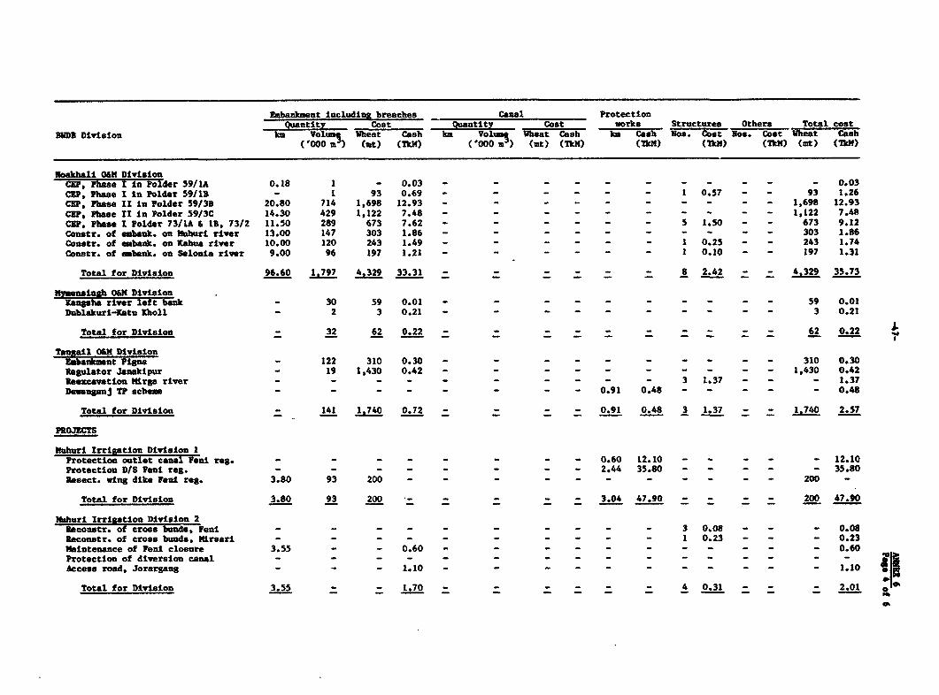
Embankment including breaches Canal ProtectionQuantity Cost Quantity Cost works Structures Others Total cost
BIDI Division km Volumq Wheat Cash km Volumt VGeat Cash km Cash Nos. Cost -os. Cost %heat Cash('000 a) (tat) (MkX) ( 000 m ) (Mt (1m) (I1M) (TkM) (TkM) (tt) (TkM)
Noakhali OUM DivisionCRP, Phase I ia Polder 59/lA 0.18 1 - 0.03 - - - - - - - - - - - 0.03CRP, Phase I In Polder 59113 - 1 93 0.69 - - - - - - 1 0.57 - - 93 1.26C8P, Phase II in Polder 59/3B 20.80 714 1,698 12.93 - - - - - - - - - - 1,698 12.93
CEP, Phase II In Polder 59/3C 14.30 429 1,122 7.48 - - - - - - - - - - 1,122 7.48CXP, Pbase Polder 73/1A & 1, 73/2 11.50 289 673 7.62 - - - - - - 5 1.50 - - 673 9.12Conastr. of embank. on Mbburi river 13.00 147 303 1.86 - - - - - - - - - - 303 1.86Conetr. of embank. on Kabua river 10.00 120 243 1.49 - - - - - - 1 0.25 - - 243 1.74
Constr. of eabank. on Selonla river 9.00 96 197 1.21 - - - - - - I 0.10 - - 197 1.31
Total for Division 96.60 1.797 4.329 33.31 - - - - - - 8 2.42 - - 4.329 35.73
nywenslAgb 0XM DivisionKangsba river lert bank - 30 59 0.01 - - - - - - - - - - 59 0.01
Dublakuri-Katu IKholl - 2 3 0.21 - - - - - - - - - - 3 0.21
Total for Division - 32 62 0.22 - - - - 62 0.22
Tangail 011 DivisionEmbankiasnt Pigna - 122 310 0.30 - - - - - - - - - 310 0.30Regulator Janakipur - 19 1,430 0.42 - - - - - - - - - - 1,430 0.42Rsexcavation tirga river - - - - - - - - - - 3 1.37 - - - 1.37
Deunganj TP schem - - - - - - - - 0.91 0.48 - - - - - 0.48
Total for Division - 141 1.740 0.72 - - - - 0.91 0.48 3 1.37 - - 1.740 2.57
PROJECTS
Nuhuri Irrigation Division IProtectlon outlet canal Feni reg. - - - - - 0.60 12.10 - - - 12.10
Protection D1S Veni reg. - - - - - - - 2.44 35.80 - - - - - 35.80
Resect. wing dike Faul reg. 3.80 93 200 - - - - - - - - - - - 200 -
Total for Division 3.80 93 200 - 3.04 47.90 - - 200 47.90
Mlhuri IrrigatIon Dividson 2PReconstr. of cross band, Feni - - - - - 3 0.08 - - - 0.08Reconstr. of cross bunds, Mirsari - - - - - - - - - - 1 0.23 - - - 0.23
Maintenance of Veni closure 3.55 - - 0.60 - - - - - - - - - - - 0.60
Protection of diversion canal - - - - - - - - - - - - - - - -
Access road, Jorargang - - - 1.10 - - - - - - - - - - - 1.10
Total for Division 3.55 - - 1.70 - - - - _ - 4 0.31 - - - 2.01 0

Embankment including breaches Canal ProtectionQuantity Cost Quantity Cost works Structures Others Total cost
BODB Division km VoluM4 Wheat Cash km Volum- Wheat Cash km Cash Nos. Cost Nos. Cost Wheat Cash('000 m') (at) (TkM) ('000 u ) (at) (TkM) (Tk14) (Tk14) (TkY) (at) (TkM)
Nadgeon ID DivisionNeogaon Polder 1 13.00 68 - 4.07 - - - 4.07
Rangpr Cana; DlvislonBodargang protection scheme - - - - - - - - 0.10 1.00 - - - - - 1.00Dharmaghat bridge - - - - - - - - 0.04 0.05 - - - - - 0.05Jamunesuari closure Balua - - - - - - - - 0.02 1.40 - - - - - 1.40Sarai protection scheme - - - - - - - - 0.17 0.60 - - - - - 0.60
Teesta Rlght EmbankmentReconstruction, Kaunia 5.00 135 185 - - - - - - - - - - - 185 -Reconstruction, Rangpur 0.40 14 18 - - - - - - - - - - - 18 -Reconstruction, Gangachara 8.20 280 390 - - - - - - - - - - - 390 -Reconstruction, Kishoregang 4.80 135 185 - - - - - - - - - - - 185 -
Total for Division 18.40 564 778 - - - - - 0.33 3.05 - - - - 778 3.05
Nilphausri MD DivisionSauri Teesta left bank embankment 10.70 133 367 - - - - - - - _ _ _ _ 367 -
Saidpur WD Divlsion IRasneth bridge - Parbatipur - - - - - - - - 0.03 0.30 - - - - - 0.30WCS - Parbitpur - - - - - - - - 0.08 0.10 - - - - - 0.10Dholaighat bridge - Taragong - - - - - - - - 0.05 0.55 - - - - - 0.55
Total for Division - - - - - - - - 0.16 0.95 - - - - - 0.95
Kurigras WD Division 1Kurigram FCG IRR - Ulipur 0.30 502 1,065 7.40 - - - - - - - - - - 1,065 7.40Kurigram FCG IRR - Rajarhat 3.70 51 261 1.42 - - - - - - - - - - 261 1.42Rurigram FCG IRR - Lalmonirhst 1.00 34 332 1.77 - 332 1.77Rurigram FCG IRR - Chatrapuri 2 0.51 93 518 3.71 - - - - - - - - - - 518 3.71Kurigram FCG IRR - Kadamtala 3.61 85 200 1.20 - - - - - - - - - - 200 1.20Kurigram FOG IRR - Demalgram 2.00 39 95 1.13 - - - - - - - - - - 95 1.13Kurigram FCC IRR - Bhuranganari 2.54 32 71 0.38 - - - - - - - - - - 71 0.38
Total for Division 13.66 836 2.542 16.63 - - - - - - - - - - 2.542 16.63
Ra%sh!h WD Division ChalanB 7eal Folder D (balance) - - 600 - - 600 1.00
0%

Embankment including breaches Canal ProtectionQuantity Cost Quantity Cost works Structures Others Total cost311DB Division km Volums Wheat Cash km Vo1um Wheat Cash k Cash Noe. Cost Nos Cost Wheat Cash
('000 m3) (mt) (TkM) ('000 a) (at) (TkM) (TkM) (Tk") (TkW) (mt) (TkY)
Natore MD DivisionChalan Beel Polder A (balance) - - 600 - -- 600 1.00Chalan Beel Polder B (balance) - - 600 - - 0- - - - - - - 1.00Chalan Beal Polder C (balance) - - 600 - - - - - - - - - - - 600 1.00Chalan Beel Polder D (balance) - - 600 - - - - - - - 600 1.00
Total for Division - - 2,400 - - - - - - - 2.400 4.00
Barisol WD Division 2Satla Bagda Polders I to 11 20.1 607 - 28.75 - - - - - - 12 3.00 - _ - 31.75
Rabigani WD DivisionXhovai River Pro lectLen"para left bank, Khowai river 1.09 185 - 0.65 - - - - 0.18 4.15 - - _ _ _ 4.80Rangargeon left bank, Khowai river 0.18 5 - 0.13 - - - - 0.12 1.57 - - - _ _ 1.70Kalianagar left bank, Kbowai river - - - - - - - - 0.06 0.75 - - - - - 0.75Anandapur left bank, Khowai river - - - - - - - - 0.09 1.12 - - - - - 1.12Laskarpur left bank, Rhowai river 0.20 5 - 0.20 - - - - 0.06 0.75 - - - - - 0.95Charhaima left bank, Rbowai river 0.30 6 _ 0.23 - - - - 0.06 0.77 - _ _ _ _ 1.00Ramnagar left bank, Khowai river - - - - - - - - 0.06 0.75 - - - - - 0.75Alapur left bank, Khowai river - - - - - - - - 0.12 1.50 - - - - - 1.50Garuhata left batk, Khwai river - - - - - - - - 0.12 1.60 - - - - - '.60Gobinpur right bank - - - - - - - - 0.31 3.50 - - - - - 3.50isidabad right bank - - - - - - - - 0.12 1.50 - - - - - 1.50Noabad rigt bank - - - - - - - - 0.18 2.23 - - - - - 2.23Mirjatula left bank, Khowai river - - - - - - - - 0.15 1.75 - - - - - 1.75Hartpur left bank, KhowaI river - - - - - - - - 0.09 1.05 - - - - - 1.05Lakripara to Kutundar - 2 - 0.03 - - - - - - - - - - - 0.03Rameree 0.46 27 - 0.85 - - - - 0.04 0.04 - - - - - 0.89Karimpur 0.16 2 - 0.05 - - - - - - - - - - - 0.05Rashergaon to Kari pur 0.25 1 - 0.02 - - - - - - - - - - - 0.02Aikandi 0.76 42 - 1.32 - - - - - - - - - - - 1.326borgaoc - - - - - - - - 0.06 0.75 - - - - - 0.75Protection of river Khowai - - - - - - - - 0.06 0.82 - - - - - 0.82
Total for Division 3.40 275 - 3.48 - - - - 1.88 24.60 - - - - - 28.08
aI


![PPAR: Bangladesh: Ganges-Kobadak Irrigation Rehabilitation ... · Title: PPAR: Bangladesh: Ganges-Kobadak Irrigation Rehabilitation Project (Loan 671-BAN[SF]) Author: Asian Development](https://img.pdfslide.net/doc/110x75/5f87bd77888d5524a31f3544/ppar-bangladesh-ganges-kobadak-irrigation-rehabilitation-title-ppar-bangladesh.jpg)


![ASIAN DEVELOPMENT BANK PPA: SRI 19190 - oecd.org · Second Road Improvement Project (Loan 864-SRI[SF]) ... PCR = project completion report, PPAR = project performance ... reductions](https://img.pdfslide.net/doc/110x75/5ac2c24b7f8b9a433f8e6f19/asian-development-bank-ppa-sri-19190-oecd-road-improvement-project-loan-864-srisf.jpg)